Introduction to Student's Research Works on.ppt · Introduction to Student’s Research ... The...
24
Introduction to Student’s Research Works on Restoration and Development in Tsunami Affected Areas An Observation of Dusun Pancer, Banyuwangi, East Java Dr.-Ing. Widjaja Martokusumo School of Architecture, Planning and Policy Development INSTITUT TEKNOLOGI BANDUNG International Symposium on “Restoration and Development of Tsunami Affected Areas in Indonesia“ at the University of Applied Sciences Erfurt, Germany, January 30-31, 2007
Transcript of Introduction to Student's Research Works on.ppt · Introduction to Student’s Research ... The...

Introduction to Student’s Research Works on Restoration and Development p
in Tsunami Affected AreasAn Observation of Dusun Pancer, Banyuwangi, East Java
Dr.-Ing. Widjaja MartokusumoSchool of Architecture, Planning and Policy Development
INSTITUT TEKNOLOGI BANDUNG
International Symposium on “Restoration and Development of Tsunami Affected Areas in Indonesia“ at the University of Applied Sciences Erfurt, Germany, January 30-31, 2007
Natural disaster: iearthquake-generated tsunami
The key issues in Indonesia’s national development agenda i ifi tl id tifi d b t l d h d are significantly identified by natural and human-made
disaster.
St ti ti h th t d i th l t d d di t i Statistics show that during the last decade disasters in Indonesia are significantly in number of occurrences, variety of the type of disasters, cost damage, affected population and homelessness.
Forest fires, floods, and landslides are regarded the main natural disasters in Indonesia (Ngoedijo, 2003). Specifically, ( g j ) p ytsunami and earthquake have been the most significant themes during the recent years in the discussion on planning and designing sustainable environment in Asia, especially in Indonesia with the case of earthquake-generated tsunamisIndonesia, with the case of earthquake-generated tsunamis

Seismic activity in IndonesiaSeismic activity in Indonesia
Source: Bambang Budiono, 2006

General tectonic overview f iof Indonesia
Source: Bambang Budiono, 2006

Pangandaran Beach July17 2006Yogyakarta May 27 2006 Pangandaran Beach, July17, 2006Yogyakarta, May 27, 2006
Source: Winardi et al., 2006

East Java Tsunami, June 3, 1994
The run-up in Pancer was measured at ca. 7.5 – 9.5 m (above the sea level) high
Source: B. Cook, 1995
p ( ) gand the impact of water with its horizontal inundation distance of 500 m wassignificant. (cf. Tsugi et al. "Field Survey of the East Java Earthquake and Tsunami of June 3, 1994." Pure andApplied Geophysics 144, 3/4, 1995).
On the other hand even the area Pulau Merah (Red Island) was also hit byOn the other hand, even the area Pulau Merah (Red Island) was also hit bytsunami, the area was relatively safe, because of the existing greenbelt trees(Jambu Alas, Eugenia sp.), which cover the shore line of Pulau Merah.
The number of human damage was then recorded 208 (cf. Hiraishi/Harada, 2003),g ( / , ),while structures damage (including homes and coastal structures partially andtotally) was recorded more than 670 (cf. Internal Report of Tsunami in East Java, June 1994.Jakarta, Java: Coastal Engineering Research Laboratory, LPTP-BPP Teknologi, 1994 and Report on Tsunami andEarthquake in East Java, June 1994. Jakarta, Java: Meteorological and Geophysical Agency, 1994)
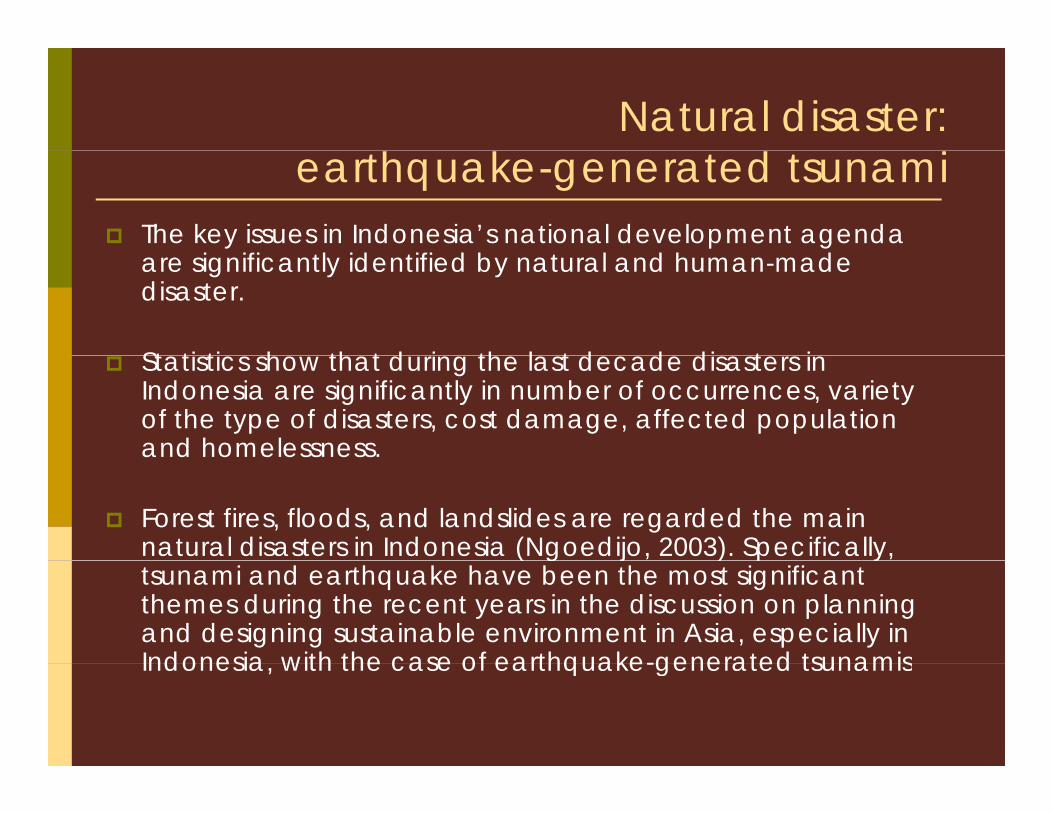
Lampon: the tidal inlet at west end of the village Tsunami attached both from the sea
Rajegwesi: pathway leading to the b h di t i
Source: B. Cook, 1995Source: B. Cook, 1995
village Tsunami attached both from the sea and from the inlet behind leaving no safe place routes
beach according to survivors about 20m land are missing$
Lampon: view of house about 220m from the shoreline Notice the buckling of the reinforced concrete column on the right
Rajegwesi: view of the beach looking south The concrete floor slabs are the only remnants of teh houses
Source: B. Cook, 1995Source: B. Cook, 1995

Pancer’s shoreline: The area shown had not been cleared by
Source: B. Cook, 1995
Pancer s shoreline: The area shown had not been cleared by buldozers, but the debris had been partially collected
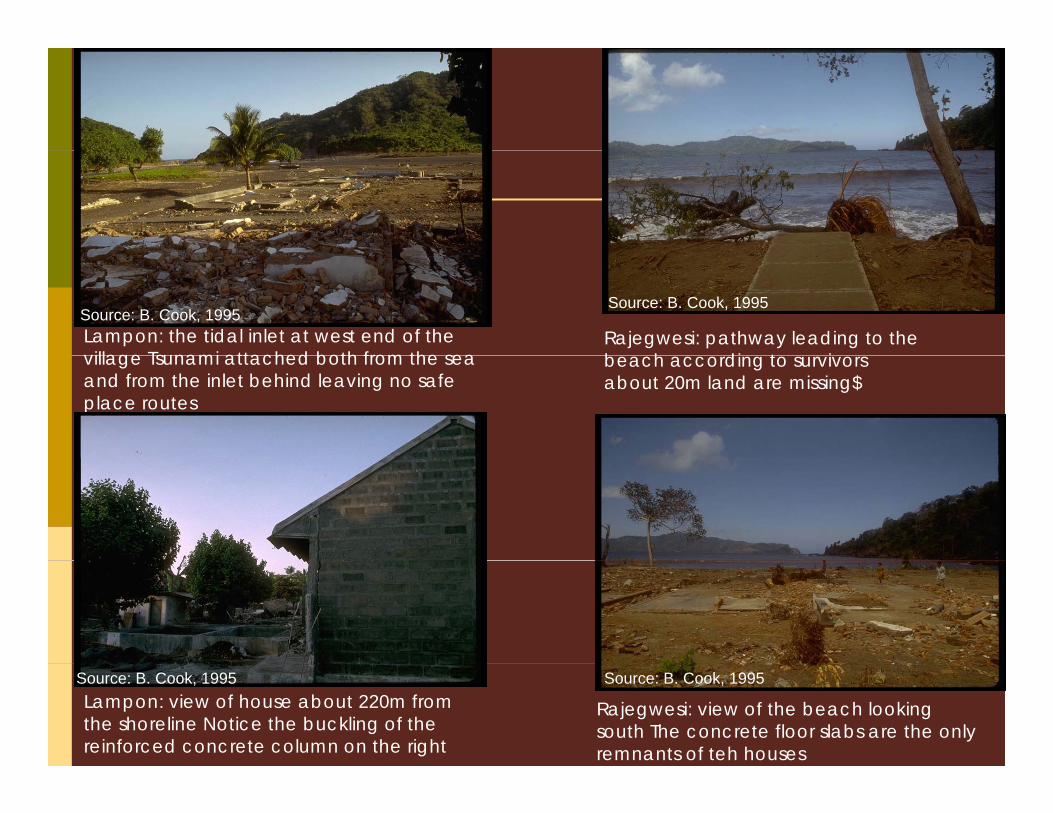
View of Pancer Kampong from shoreline: building debris had been cleared for recycling, while the plant debris is still there
Source: B. Cook, 1995

View of partially damaged seawall at the west of the Pancer Kampong during the low tide
Source: B. Cook, 1995

View of the only surviving house south of the main road which was located less than 200m from the shoreline of Pancer
Source: B. Cook, 1995

The waterline inside a house in Pancer Kampong
Source: B. Cook, 1995
iPost-Disaster DevelopmentAfter the attack of tsunami, a new area of PERHUTANI in the northern part of main Kampong road Pancer ca 50 ha) was northern part of main Kampong road Pancer ca. 50 ha) was opened for agriculture/cultivation for improving economic income of the kampong inhabitants. (ca. 200 ha, in 2006)
On some areas, called Pancer Babatan, situated in the north part of Pancer’s main road, the inhabitants are still allowed to cultivate and utilise the land in certain periods of time for their daily needs.y
Only 10 % of the whole inhabitants of Pancer Kampong participated in theTransmigration-program, with the first settlement relocation to Irian Jaya (ca 27 households) and settlement relocation to Irian Jaya (ca. 27 households) and the second relocation program to Central Sulawesi (ca. 60 households).

P E t JPancer, East Java
Aerial view of Pancer Kampong in Aerial view of Pancer Kampong in 1994 (top) prior to tsunami disaster and in 2006 (bottom) that show the deforestation in the hinterland of the kampong after tsunamip g
Source: Bakosurtanal aerial photography (1994) and Google earth (2006)earth (2006)

Dusun Sungai Lembu
Dusun Redjoagung
Dusun Silirbaru
Dusun PancerDesa Sumberagung

Pancer, East Javaca. 1935: opening land
activities in the south part of Banyuwangi regency near Banyuwangi regency, near Mount Tumpang Pitu, Mount Lompong, Mount Bayur and Kapur Hill.
1968: The first fishermen’s
Pancer Babatan
1968: The first fishermen s settlement was planned and erected in at Pulau Merah (Red Island) for 15 households
1970: construction of main Pancer’s Portroad to the port. Followed by the building of small depots, permanent/semi-permanent dwellings of local fisherman/small trader.
1976-1979 due to the population growth and the rapid development of local fishery the provincial government fisherman
Red Island
gsettlement with its basic facilities had been formalised.

iSome issues …Landownership .The case of the area Pancer Babatan is an example of this problem in which for the time being farmers can still utilise and of this problem, in which for the time being farmers can still utilise and cultivate the land, which owned by the PERHUTANI (National Forestry Agency).
The population dynamic in Pancer Inhabitants of Pancer are mostly The population dynamic in Pancer. Inhabitants of Pancer are mostly fishermen, and during the low season of fishing, either they continue to migrate to other places looking for fishing or they work as farmers. The latter has contributed to deforestation at the northern part of the area.
The Pancer Kampong is still is vulnerable of the tsunami hazard. Efforts to redesign the settlement and its surrounding environment, e.g. free zone -green belt- had never been accomplished, while g p ,environmental degradation, e.g. erosion, sedimentation, becomes recently more significant
Some basic facilities for fishery and fishing activities are considered So e bas c ac es o s e y a d s g ac es a e co s de ed very poor, and the existing buildings and structures are mostly non-engineered and are not earthquake resistant either.
iCollaborative Workshop Given the facts that Indonesia has such a diverse marine estate, well-established cultural traditions, and a significant economic dependence on coastal and marine resources and possible natural coastal and marine resources and possible natural disaster, yet surprisingly there has been no integrated and/or systematic approach in
i t l t ( dij 2003) environmental management (Ngoedijo, 2003). From this point of view the issue of sustainable development must address in the future the main development must address in the future the main challenges of natural disaster, i.e. earthquake and tsunami.

iTime scheduleJanuary, 2006: 1st field trip to Sumberagung Village, P Pancer
February, 2006: 1st Workshop Presentation and y pdiscussion (Identifying problems and issues on area development ), ITB, Indonesia
July, 27 – 31 2006: 2nd field survey to Banyuwangi, Pancer, East Java
January, 2007: final presentation (papers and design) in Erfurt

1st field trip to Pancer, January 20061 field trip to Pancer, January 2006

2nd Field trip to Pancer, July 2006

iLandscape architectureThe first group of students, focusing on landscape
hit t ill i t i l k th f ll i bl architecture, will intensively work on the following problem statements and develop design ideas/schemes. Problem statements for the settlement planning and design are as follows:follows:The relation of economic activities and social conflicts influences the settlement and spatial planning and design of the Sumberagung Village. A development of the comprehensive spatial village plan must minimize the impact of tsunami in the future.The output of the works, i.e. conceptual design ideas, and th t h ld b t d i f f t l f P that should be presented in form of master plan of Pancer Kampong, illustrative site plan, model of settlement patterns, neighbourhood plan of the area involved.

i i iBuilding construction/methodRegarding to the spatial plan and settlement pattern mentioned above the second/third group of our students (specializing in above, the second/third group of our students (specializing in Architecture and Building Construction/Method) will correspondingly focus on a study of housing and building typology. Their works should be highlighted by these two problem statements: A design of temporary buildings must consider the dynamic A design of temporary buildings must consider the dynamic fisherman activities and address the question of utility during the low fishing season.A development of building design and construction using local materials and appropriate technology has to resist the earthquake pp p gy qforce and consider the impact of the tsunami.Students will have to develop ideas on housing and possible public facilities, which accommodate the local activities. The students propose other possible common buildings/relevant facilities, which
h th i l d i f th l l With d t i l enhance the social dynamic of the locals. With regard to social dynamic and cultural background an introduction to any “new” building material is also encouraged.

iConcluding Remarks
Workshop : Why Pancer? Unique & dynamic, Workshop : Why Pancer? Unique & dynamic, accessibility, tsunami prone area, recent developmentIllustrative ideas and concept, hypotheticalProblems, limitations and challengesgJoint-PublicationFurther joint-studies on some other cities, u e jo s ud es o so e o e c es, settlement typologies etc.Acknowledgementsg


