INTRODUCTION Previous Work
8
47 GEOMORPHOLOGIC ANALYSIS OF FORILLON NATIONAL PARK, QUEBEC, CANADA MURRAY A. ROED Geo-analysis Limited, 1725 St. Laurent Blvd., Ottawa, Ontario, CANADA K1G 3V4 INTRODUCTION This paper summarizes the geomorphology of Forillon National Park, Quebec, The work is pri- marily a photo geologic interpretation in conjunction with a literature review conducted during the period March 20 to April 20, 1978. A geomorphic map at a scale of 1:100 000 accompanies the paper and for the first time presents a comprehensive inventory of principal geomorphic features of the park classified according to age and process. Also, the mapping has developed new information with regard to glacial and pre-glacial geomorphic features. Despite a great many past studies in the park few have concentrated on the geomorphology and, therefore, little quantitative data exists. It is important to point out that this work has been completed without the benefit of a field check. A considerable amount of field work would be necessary to map the park adequately and to establish the ground truth on which it is based. Therefore, this paper is considered to be prelimin- ary. Physiographic Setting Forillon National Park consists- of an area of about 240 km2, located at the eastern tip of the Gaspe Peninsula, Quebec. It is bounded on the south by Gaspe Bay, on the north by the St. Lawrence River and on the west by Highway 197 and Renard River. Topography is generally mountainous with elevations ranging from sealevel to 550 m. The area is dominated by a southerly trending part of the Schishock range of the Appalachian Mountain system. The mountains comprise two dis- tinct groups of rocks: one is a sequence of sand- stone and limestone of Devonian age that dips uni-' formly to the southwest and forms a resistant spine or hogback adjacent to Gaspe Bay, and the other is a series of highly folded less resistant schists and phyllites of Ordovician-Cambrian age that occupies the northeastern part of the park and un- conformably underlies the Devonian rocks. The northern boundary of the Appalachian Mountains occurs just to the northeast of the park along the St. Lawrence River marked by Logan's Line. In general, the park is well drained due to its high topographic relief and the occurrence of near- surface bedrock and a thin mantle of dominantly granular soil. Most streams including two larger rivers, the Griffon Cove and Renard Rivers, drain to the St. Lawrence River, whereas a series of smaller but higher gradient streams drain to Gaspe Bay. Method of Study Geomorphic features of Forillon Park have been mapped using aerial photographs at a scale of 1: 50 000 taken in 1976. This information was trans- ferred directly onto a planimetric base of the area with the aid of a topographic overlay (contour interval = 50 ft.). In addition, low level oblique colour transparencies of the sea cliffs of the peninsula were examined and all geomorphic features were identified on the film and then located and shown in Figure 1. All relevant data from a review of principal scientific publications were also transferred onto Figure 1, Especially that compiled by Cumming (1976). Colour slides on file with Parks Canada were examined. These depict principally post-glacial geomorphic features. Previous Work Geological work in the park has been reviewed by Cumming (1976) . Prest (in Douglas 1970), McGerrigle (1952) and Maldague (1973) are the main references for glacial geology. The majority of work in Forillon Park has concentrated on the stratigraphy and paleontology of the Paleozoic bedrock whereas surprisingly little specific data are available on the surficial geology, considerably less on the geomorphology, and nothing on engineering geology. GEOMORPHIC PROCESSES The geomorphic processes that have been at work in Forillon National Park can be divided into those that occurred in pre-glacial time, those that occurred in glacial time, and those that are post- glacial or occurring now and immediately following glacial times. Each of these time divisions is discussed below, and the features in the park that represent examples of the processes in each of these time intervals are shown in Figure 1. Post-glacial Features formed by post-glacial processes in- clude present coastal erosion and sedimentation, alluvial erosion and sedimentation, colluvium formation, and development of organic terrain. Features formed in immediately post-glacial time (an alpine glacial phase) are included in glacial processes. The possibility of permafrost pockets exists in upland localities, especially in organic depressions as inferred from McGerrigle (1952, p. 48) in Cummings (1976, p. 254). Coastal Processes The best examples of landforms formed by coastal processes include the formation of a tombola- spit landform at Baie de Penouille and the sea cliffs of Forillon Peninsula. Development of Baie de Penouille and the associated peninsula is an example of tombola formation by the interaction of coastal processes and alluvial processes. The interpretation pre- sented here is that the tombola formed by deposition of alluvium into the sea (a delta) at the mouth of Ruisseau Ascah which must have interfered with west- ward longshore drift along Gaspe Bay and caused a MARITIME SEDIMENTS, Vol. 15, Nos. 2 and 3, August-December, 1979, pp. ^7-54
Transcript of INTRODUCTION Previous Work
47
G E O M O R P H O L O G I C A N A L Y S I S O F F O R I L L O N N A T I O N A L P A R K , Q U E B E C , C A N A D A
MURRAY A. ROED Geo-analysis Limited, 1725 St. Laurent Blvd., Ottawa, Ontario, CANADA K1G 3V4
I N T R O D U C T I O N
This paper summarizes the geomorphology of Forillon National Park, Quebec, The work is pri-marily a photo geologic interpretation in conjunction with a literature review conducted during the period March 20 to April 20, 1978.
A geomorphic map at a scale of 1:100 000 accompanies the paper and for the first time presents a comprehensive inventory of principal geomorphic features of the park classified according to age and process. Also, the mapping has developed new information with regard to glacial and pre-glacial geomorphic features. Despite a great many past studies in the park few have concentrated on the geomorphology and, therefore, little quantitative data exists.
It is important to point out that this work has been completed without the benefit of a field check. A considerable amount of field work would be necessary to map the park adequately and to establish the ground truth on which it is based. Therefore, this paper is considered to be prelimin-ary.
P h y s i o g r a p h i c Set t ing
Forillon National Park consists- of an area of about 240 km2, located at the eastern tip of the Gaspe Peninsula, Quebec. It is bounded on the south by Gaspe Bay, on the north by the St. Lawrence River and on the west by Highway 197 and Renard River. Topography is generally mountainous with elevations ranging from sealevel to 550 m.
The area is dominated by a southerly trending part of the Schishock range of the Appalachian Mountain system. The mountains comprise two dis-tinct groups of rocks: one is a sequence of sand-stone and limestone of Devonian age that dips uni-' formly to the southwest and forms a resistant spine or hogback adjacent to Gaspe Bay, and the other is a series of highly folded less resistant schists and phyllites of Ordovician-Cambrian age that occupies the northeastern part of the park and un-conformably underlies the Devonian rocks. The northern boundary of the Appalachian Mountains occurs just to the northeast of the park along the St. Lawrence River marked by Logan's Line.
In general, the park is well drained due to its high topographic relief and the occurrence of near-surface bedrock and a thin mantle of dominantly granular soil. Most streams including two larger rivers, the Griffon Cove and Renard Rivers, drain to the St. Lawrence River, whereas a series of smaller but higher gradient streams drain to Gaspe Bay.
Method of Study
Geomorphic features of Forillon Park have been mapped using aerial photographs at a scale of 1: 50 000 taken in 1976. This information was trans-ferred directly onto a planimetric base of the area with the aid of a topographic overlay (contour
interval = 50 ft.). In addition, low level oblique colour transparencies of the sea cliffs of the peninsula were examined and all geomorphic features were identified on the film and then located and shown in Figure 1.
All relevant data from a review of principal scientific publications were also transferred onto Figure 1, Especially that compiled by Cumming (1976). Colour slides on file with Parks Canada were examined. These depict principally post-glacial geomorphic features.
P r e v i o u s Work
Geological work in the park has been reviewed by Cumming (1976) . Prest (in Douglas 1970), McGerrigle (1952) and Maldague (1973) are the main references for glacial geology. The majority of work in Forillon Park has concentrated on the stratigraphy and paleontology of the Paleozoic bedrock whereas surprisingly little specific data are available on the surficial geology, considerably less on the geomorphology, and nothing on engineering geology.
G E O M O R P H I C P R O C E S S E S
The geomorphic processes that have been at work in Forillon National Park can be divided into those that occurred in pre-glacial time, those that occurred in glacial time, and those that are post-glacial or occurring now and immediately following glacial times. Each of these time divisions is discussed below, and the features in the park that represent examples of the processes in each of these time intervals are shown in Figure 1.
P o s t - g l a c i a l
Features formed by post-glacial processes in-clude present coastal erosion and sedimentation, alluvial erosion and sedimentation, colluvium formation, and development of organic terrain. Features formed in immediately post-glacial time (an alpine glacial phase) are included in glacial processes. The possibility of permafrost pockets exists in upland localities, especially in organic depressions as inferred from McGerrigle (1952, p. 48) in Cummings (1976, p. 254).
C o a s t a l P r o c e s s e s
The best examples of landforms formed by coastal processes include the formation of a tombola-spit landform at Baie de Penouille and the sea cliffs of Forillon Peninsula.
Development of Baie de Penouille and the associated peninsula is an example of tombola formation by the interaction of coastal processes and alluvial processes. The interpretation pre-sented here is that the tombola formed by deposition of alluvium into the sea (a delta) at the mouth of Ruisseau Ascah which must have interfered with west-ward longshore drift along Gaspe Bay and caused a
MARITIME SEDIMENTS, Vol. 15, Nos. 2 and 3, August-December, 1979, pp. ^7-54

48
spit to be formed. Eventually the spit grew and merged with the deltaic deposits to form a tombola. The abrupt straight edge on the western part of the tombola may be explained by the unique interaction of tidal currents and river currents from both Dart-mouth and York Rivers. This interpretation means that the lagoon is slowly filling due to deltaic sedimentation and overwash along the spit and, in time, the tombola will merge with the shore com-pletely to form a broad sand bar.
Sea cliffs are the most striking geomorphic coastal feature in the area. The coast between Cap Gaspe and Cap Rosier with cliffs up to 200m high is a high wave-energy zone with a wind fetch of 300 km (Owen and Harper 1972). Three basic erosional pro-cesses occur along the coast and include under-cutting by wave erosion, subsequent rock fall and landslide due to removal of support, and rock fall as a result of frost action. Direct abrasion of the shoreline by shifting and shorefast ice is one aspect of ice erosion, and the other is that material falls onto the ice and is removed by the ice during break-up. The shorefast ice also acts as a defense against wave action.
Wave erosion results in the formation of sea caves and pot holes, differential erosional features, shoreline retreat, and the sedimentation of beach sand the gravel. The beach deposits along Forillon Peninsula are almost entirely due to reworking of talus deposits and, to a very minor degree, to head-land erosion of the small resistant outcropts such as Cap Bon Ami.
Along the eastern coast, shoreline erosion is not to be underestimated and should receive con-siderably more quantitative study. Specifically, it "should be possible to determine the rate of erosion "using instruments for monitoring present erosion, by the examination and study of air photos and maps, by the analysis of offshore morphology (marine geomorphology), and by interviewing long-time residents of the area.
Erosion by waves and frost along Gaspe Bay is less severe than in the vicinity of Cap Bon Ami and Forillon cliffs. Longshore currents are the most important agents of transport along Gaspe Bay, but the shoreline has been little modified since glacial ice disappeared.
A l l u v i a l P r o c e s s e s
Present alluvial erosion and depositipn com-prise two main types: that in high gradient streams, and that in low gradient streams. High gradient streams are characterized by rocky bouldery channels, waterfalls, and steep cut banks.
Two streams with particularly well developed cut banks are Ruisseau Beaudry and Ruisseau du Cap des Rosiers where it cuts through moraine as shown in Figure 1). Low gradient streams include Riviere au Renard and Riviere de l'Anse au Griffon (both marked by a shallow meandering type of flood plain in their lower parts but not delineated in Figure 1). Waterfalls are common features.
All streams give rise to small deltas as they enter the sea. The best manifestation of such deltas is the Ruisseau Ascah.
The cutbanks of most streams in the alluvial map unit (No. 1 in Figure 1) in the area may be subject to small slumps. Careful study of these localities is required prior to development of any
kind. Specific setbacks from scarp edges may be required for construction of camp sites adjacent to alluvial terrain.
Organic Depos i t ion
Organic terrain is not common in the park but occurs in poorly drained depressions in lowland and upland localities. The principal process of form-ation is the anaerobic breakdown of vegetation and gradual accumulation of sphagnum moss. Samples of peat at the base of such terrain may yield material that could be dated and thus provide a. minimum age of deglaciation of the area.
All organic and alluvial terrain should be avoided for development due to poor drainage, poor foundation conditions and possible erosion.
C o l l u v i a l P r o c e s s e s
Rockfalls and landslides due to undercutting are manifested by large and small piles of broken angular rock that occur in colluvial deposits along slopes and at the base of steep rock faces. Talus fans occur where frost action is an on-going pro-cess. Colluvium formed by solid creep is common in the park.
L a n d s l i d e s
Minor rockslides are present along the sea cliff of Forillon Peninsula, and can be expected anywhere the ocean is actively undercutting the cliff.
A possible large deep seated landslide may have created the terrace on which the Cap Bon Ami facilities are located. A detailed investigation of this possibility has not been conducted to the writer's knowledge. Certain features of this land-form, none of which is conclusive, suggest a land-slide origin. First, it is an anomolous landform in em otherwise high steep bedrock shoreline. Its geo-morphology is suggestive of a large slump block because its position is compatible with the idea that it may have slipped from a higher position on the face of Mount St. Alban, and thus interpreted as a landslide scar. Russell (in Cummings 1976, Vol, 7, p. 273) has -mapped faults on both ends of the landform. Other smaller landslides have been identified in the present work. This type of erosion therefore, is characteristic along this stretch of coastline. From an examination of the 9 inch x 9 inch colour negatives (low-level air photos) it is clear that a marked structural discontinuity exists at the base of the slope of this landform. This feature is easily observed in the photos and could be a slip plane of a landslide. Also, it was noted that the strata exposed along the slope of this land-form are remarkably similar to strata exposed further to the south along the shoreline - a repetition of strata is therefore suspected and further suggests a landslide origin for this terrace-like feature.
On the other hand, this terrace-like landform is similar to other high level terraces that have been found in the present work, and it could simply be a remnant of one of these features. Also, a number of geologists in the past have examined this feature and none suggested a landslide origin to the writer's knowledge. Most of these geologists, however, were not specifically trained in engineering

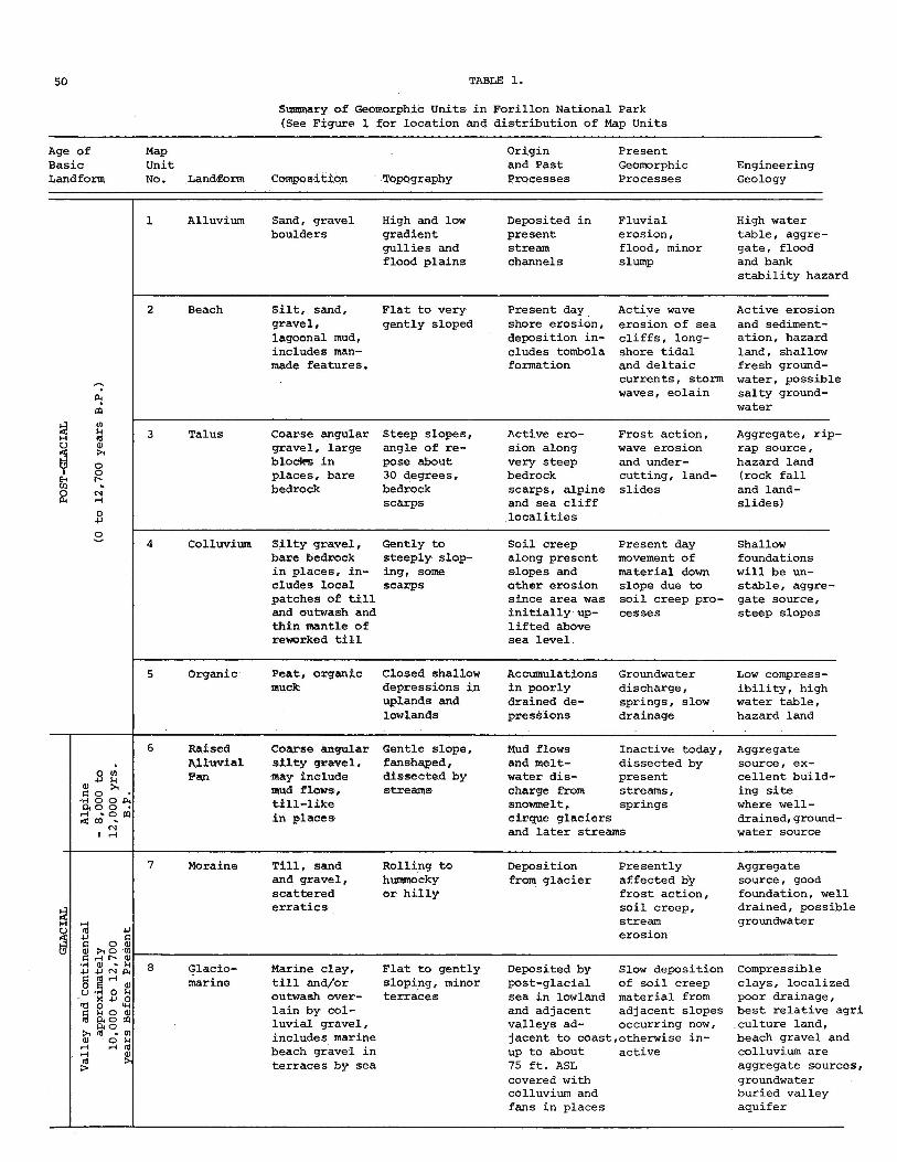
50 TABLE 1.
Summary of Geomorphic Units in Forillon National Park (See Figure 1 for location and distribution of Map Units
Age of Map Origin Present Basic Unit and Past Geomorphic Engineering Landform No. Landform Composition Topography Processes Processes Geology
Alluvium Sand, gravel boulders
High and low gradient gullies and flood plains
Deposited in present stream channels
Fluvial erosion, flood, minor slump
High water table, aggre-gate , flood and bank stability hazard
Ch CO in n id & o o
2 Beach Silt, sand. Flat to very Present day Active wave Active erosion gravel. gently sloped shore erosion, erosion of sea and sediment-lagoonal mud, deposition in- cliffs, long- ation , hazard includes man- cludes tombola shore tidal land, shallow made features. formation and deltaic fresh ground-
currents, storm water, possible waves, eolain salty ground-
water
3 Talus Coarse angular Steep slopes. Active ero- Frost action, Aggregate, rip-gravel, large angle of re- sion along wave erosion rap source, blocire in pose about very steep and under- hazard land places, bare 30 degrees. bedrock cutting, land- (rock fall bedrock bedrock scarps, alpine slides and land-
scarps and sea cliff slides) localities
4 Colluvium Silty gravel, Gently to Soil creep Present day Shallow bare bedrock steeply slop- along present movement of foundations in places, in- ing, some slopes and material down will be un-cludes local scarps other erosion slope due to stable, aggre-patches of till since area was soil creep pro- gate source. and outwash and initially up- cesses steep slopes thin mantle of lifted above reworked till sea level.
5 Organic Peat, organic Closed shallow Accumulations Groundwater Low compress-muck depressions in in poorly discharge, ibility, high
uplands and drained de- springs, slow water table. lowlands pressions drainage hazard land
Raised Alluvial Fan
Coarse angular Gentle slope. silty gravel, may include mud flows, till-like in places
fanshaped, dissected by streams
Mud flows and melt-water dis-charge from snowmelt, cirque glaciers and later streams
Inactive today. Aggregate dissected by present streams, springs
source, ex-cellent build-ing site where well-drained, ground-water source
Moraine
•H m •p •u c G o m m >1 o •in c rH I'- (i)
•H ll) - i-i 4J -p CN 04 c g H o g <11 IJ -H 0 n
X 4J 0 • r t 0
n o <11 m o, o DO
a< o >i fl - II) a) o M rH r—1 in H 0) nl > >
Till, sand and gravel, scattered erratics
Rolling to huramocky or hilly
Deposition from glacier
Presently affected by frost action, soil creep, stream erosion
Aggregate source, good foundation, well drained, possible groundwater
Glacio- Marine clay, marine till and/or
outwash over-lain by col-luvial gravel, includes marine beach gravel in terraces by sea
Flat to gently Deposited by Slow deposition sloping, minor post-glacial of soil creep terraces sea in lowland material from
and adjacent adjacent slopes valleys ad- occurring now, jacent to coast,otherwise in-up to about active 75 ft. ASL covered with colluvium and fans in places
Compressible clays, localized poor drainage, best relative agri culture land, beach gravel and colluvium are aggregate sources, groundwater buried valley aquifer

51
TABLE 1 (Continued)
Age of Map Origin Present Basic Unit and Past Geomorphic Engineering Landform No. Landform Composition Topography Processes Processes Geology
Veneered Lowland
Till and colluvium re-worked; bed-rock and gravel patches, thin surficial material
Rolling to gently sloping
Pre-glacial erosion of lowland, glaciated by Gaspesian Ice Cap and valley glaciers
Present frost action, erosion along sea cliffs soil creep along slopes, re-worked
Aggregate source, poor farmland, good found-ation, bed-rock near surface
10 Rolling Thin layer of Flat to gently Lowland till and re- rolling, bor-
sidual mat- dered by rolling erial over bed- slopes, terrace-rock, reworked, like gravel patches
Pre-glacial Soil creep Soil creep erosion, eroded along slopes along slope? by valley bedrock near glacier and surface Gaspesian Ice Cap.
11 Veneered Upland
Thin layer of colluvium and moraine over bedrock
Gently rolling terrace-like, local de-pressions
Pre-glacial Frost action erosion deve- and soil creep lopment of presently terrace then uplift and dis-section by streams, affect-ed by alpine glaciers Gaspesian Ice Cap
Poorly drained in places, some steep slopes, bed-rock near sur-face , deep groundwater aquifers, possible permafrost pockets
12 Bare Scattered Upland boulders and
granular resi-dual soil, but mainly bare bedrock
Steep slopes, cliffs, rolling depressions
Pre-glacial erosion with development of terrace or peneplain, sub-sequent uplift and dissection by streams in Tertiary Cret-aceous, affected hy alpine gla-ciers and poss-ibly Gaspesian Ice Cap
Frost action and soil creep presently
Bedrock at surface, well drained, steep terrain, scarps, deep ground-water aquifers, possible perma-frost pockets

52
geology and were primarily interested in the strati-graphy and paleontology of the exposed strata. Cumming (1976 p. 189) refers to a gravity slump structure at the subject locality but relates its origin to a Paleozoic disturbance shortly after deposition of the strata; this should not be con-fused with a possible recent landslide origin for the entire terrace-like landform suggested here.
T a l u s
Talus is a form of colluvium but since most talus piles or wedge-shaped fans are so distinct and bare of vegetation, they have been identified separately in Figure 1. All terrain mapped as talus (map unit 3 in Figure 1) is subject to rock-fall and is therefore hazardous.
Soil C r e e p P r o c e s s e s
Colluvium due to soil creep is the most common surficial deposit in the park, and is being formed on most slopes of the area. The process is mani-fested in road cuts by a layer of residual soil which in some cases resembles till and in many places is stratified. Layers of this soil more or less parallel the slope.
Terrain mapped as colluvium (map unit 4 in Figure 1) is subject to soil creep, in which the upper metre or two of residual soil is slowly moving downhill. Foundations in'this material will be unstable, and roads or trails constructed in this unit may be subject to high maintenance costs to remove fallen material and repair warped road sur-faces .
G l a c i a l
Glacial features in the jiark are numerous but few are spectacular. They consist of erosional and depositional forms. Erosional glacial features include a wide variety of alpine landforms such as cirques, cols, faceted spurs, aretes or knife edge ridges, pater noster lakes, U-shaped valleys and gouged or grooved bedrock. Depositional features include moraine composed of till and (or) outwash sand and gravel, a possible kettle lake in morainal material, raised alluvial fans that were likely deposited by meltwater from small cirques, glaciers, marine clay in the lowlands, and marine gravel in the terraces adjacent to the coast. These features and specific examples of most are shown in Figure 1.
EROSIONAL ORIGIN
Erosional glacial features include cirques, faceted spurs, aretes, cols, pater noster lakes, grooved or gouged bedrock and U-shaped valleys.
Two levels of cirques are believed to occur: one at an elevation of 274 m (900 feet) and the other at 427 m (1400 feet). The highest cirques are the youngest and most distinct. Lowland cirques and pre-glacial terraces similar to those discussed in this report are known to occur on the west coast of British Columbia adjacent to Hecate Strait.
Faceted spurs, aretes and cols are numerous in the park and are evidence of erosion by valley glaciers. Pater noster lakes also occur at the head
waters of Ruisseau Ascah. Gouged bedrock such as the steep linear south-facing slope along Gaspe Bay could have only been formed by a massive outlet glacier of the Gaspesian ice cap which likely coalesced with another outlet glacier that flowed down York River.
Large valleys such as that of Griffon Cove River were abraded, overdeepened in part, and carved into U-shaped valleys by glacial ice. These valleys, however, are not classic U-shaped valleys, in fact many of them are more V-shaped and indicative of light glacial erosion compared with, for example, those in the Rocky Mountains and Coast Ranges.
DEPOSITIONAL ORIGIN
Glacial features of depositional origin include low marine terraces, lateral and ground moraine, kame and kettle, and glacial erratics.
Marine clay and marine gravel terraces were formed during a brief period of ocean flooding that occurred immediately following the disappearance of the Gaspesian ice cap. In high energy environments, as in the vicinity of Cap des Rosiers, pebble to cobble beach gravel was deposited in terraces; in sheltered but flooded valleys, such as Griffon Cove River valley, marine clay was deposited. Numerous marine shells can be found in this clay in places and these have been dated. Near the mouth of Griffon Cove River, the Carbon 14 method was employed to date shells found there. An age of 12,400 years B.P. was obtained (Prest, personal communication, 1978). This means that no glacial ice existed and also, that the St. Lawrence River was likely free of ice at that time. This age thus provides a date for the end of the continental phase of Wisconsin glaciation in this region. Dr. Prest also found shells (dated at 12,700 years B.P.) in marine clay 1.6 km south of Riviere au Renard near the park boundary. The clay occurs as en eroded terrace overlain in places by outwash gravel which indicates an ice advance after marine invasion at this locality.
Till and outwash gravel occur in ground and (or) lateral moraine of the park. The till is very silty and clayey and has a wide variety of sizes of pebbles and boulders. Gravel deposits are not numerous.
A possible kettle lake occurs just below and south of the crest of Mount St. Alban. Another one occurs just to the west of the park boundary at an elevation of 274 m (900 feet) 1.6 km east of Morris.
Although glacial erratics of granite composition from a Canadian Shield source to the north have not been found in the park to date, which means that the Laupentide continental glacier did not reach the park, the most favourable place to search for such erratics would be in the uplands of the northeastern part of the park. Here a very thin layer of till is thought to occur in places overlying the bedrock. In many localities the till may be represented only by scattered stones.
P r e - g l a c i a l F e a t u r e s
Pre-glacial geomorphic features are well repre-sented in the park but are somewhat obscure to a casual observer because of the scale of the features. These include a series of erosional terraces that

53
compose the uplands, midlands and lowlands of the park. The terraces have all been modified by ice cap and alpine glaciation, and colluvial processes, but basically consist of a gently rolling surface flanked by a scarp or break in slope that gives way to a steep slope. The surfaces of the terraces are poorly defined in some places but four surfaces, as listed below, have been recognized in the present work and all appear to have been tilted or warped in some manner.
Pre-glacial Elevation of Surface Terraces (in feet)
Map Unit 12 1000 rising NW to 1800 Map Unit 1L 700 rising NW to 1250 Map Unit 10 300 rising NW to 1000 Map Unit 9 100 rising NW to 500
The terraces may represent successive levels of erosion that were attained in certain erosional intervals during Cretaceous and Tertiary time. That is, for example, the highest level was at one time sealevel in the area, and has since been uplifted, and so on, down to the lowest terrace level. The combined perspective and topographic cross-section of Figure 2 is provided to help illustrate these features.
Very little is known about these terraces, however, the opinion expressed here is that these terraces are ancestral to the uplifting and tilting of the continental margin in the Cretaceous-Tertiary portion of pre-glacial time (see also Mathews 1974) .
The other visible feature related to pre-glacial geomorphic development is the present stream pattern which is thought to be largely pre-glacial in origin, and only slightly modified by glacial processes. The main manifestation of pre-glacial origin is the way the major valleys of Griffon Cove River and Renard River have been truncated by glacial erosion along Gaspe Bay, and the neat V-shape of some of the other valleys as opposed to a distinct U-shaped glacially eroded valley.
SUMMARY A N D C O N C L U S I O N S
- The broad geologic events that have affected Forillon Park are summarized below. This provides a framework for identification of certain geomorphic features shown in Figure 1 that relate to various past and present events in the park. A summary of geomorphic features is given in Table 1 which should be used in conjunction with Figure 1.
The geomorphic evolution of Forillon National Park begins in late Precambrian time when the ancient Laurentian Mountains dominated this part of the land. Then the Acadian continental marginal basin began to develop in early Cambrian time. Land-derived detritus was poured into this basin throughout Cambrian and Ordovician times and resulted in a very thick accumulation of mainly limestone - shale and carbonate sands (St. Julien and Hubert 1975). The instability of the earth's crust then increased considerably, which resulted in intense folding, faulting, and metamorphism. This was the Taconic Orogeny and was so intense that large slabs of allocthonous schistose rock, or klippen, were physically dislocated and shoved many kilometres to the north (St. Julien and Hubert 1975) . Also, gravity sliding occurred but nappes are not present in the park. The schistose rocks that out-crop in the northeastern part of the park belong to klippes of the allocthonous sequence.
A long period of erosion occurred throughout much of Silurian time. Then in Devonian time another sedimentation basin developed along the modern Appalachian Mountains (Williams in Price and Douglas 1972). Thick sequences of limestone and shale were deposited and volcanic activity occurred in places. Towards the end of Devonian time this basin was deformed during the Acadian Orogeny. Also, the rocks were intruded by granite at Mt. McGorigle and, finally, the region became a stable rising landmass.
The Appalachian landmass was at one time mountainous, but erosion reduced the region to nearly a flat plain. For example, all of the Paleozoic rocks were stripped from the Laurentian Mountains area. This erosion occupied the time between the late Devonian and the Jurassic Periods, some 300 million years, and the erosional plain that formed
cirque NORTHEAST A' • 600
'Park Boundary •• 1 2 , 0 0 0 'Pork Boundary
2 <t
F I G . 2 Four gently ro l l ing erosional surfaces (poorly def ined terraces) can be dist inguished in For i l lon Park as depicted in this
sketch or perspect ive a long topographic cross-sect ion A ~ A ' ( locat ion shown in F i g . 1). Arrows indicate the various leve ls
- these are bel ieved to be related to periods of up l i f t , erosion and gradual d issect ion of the A t lan t ic Penep la in . A low
terrace designated M re la ted to post -g lac ia l marine invasion is s i tuated 15 to 23 meters above sea level and should not be
confused with the older high terraces. T w o leve ls of cirques are a lso depicted in this a r t i s t ' s sketch.

54
has been called the Atlantic Peneplain (King in Price and Douglas 1972, p. 252).
In Jurassic time the Atlantic Ocean as we know it began to form between North America and Europe. This caused uplift of the Atlantic Peneplain and tilting of it toward the south. Therefore, through-out much of the Cretaceous and Tertiary Periods the Gaspe Peninsula area and the Canadian shield to the north were subject to further erosion whereas in the offshore part of the coast (the modern Gulf of St. Lawrence) subsidence occurred and sediment derived from the Gaspe and other land areas was deposited. The tops of the highest hills in Forillon Park, as well as, although modified by fluvial erosion during successive intervals, by glacial erosion, may represent ancestral remnants of the Atlantic Peneplain.
Break-up and drifting of the continents, which is still going on today, continued and was accompanied first in the Early Cretaceous by igneous intrusions, some of which occur in the Monteregian Hills, and then by faulting. A fault graben may have developed along the St. Lawrence at this time, according to some authors, and this could have created the ancestral valley of the modern St. Lawrence River (Kumarapelli 1976).
By Quaternary time the basic land features consisting of terraced uplands and lowlands, and V-shaped valleys in Forillon National Park had been created. Although four major glacier advances took place during the Pleistocene Epoch of the Quaternary Period, at Forillon there is evidence for only one ice cap that probably engulfed the area. This was the Gaspesian Ice Cap and it spread from central Gaspe about 100,000 years ago during Wisconsinan time. Gaspesian ice presumably met the Laurentide continental glacier along the St. Lawrence River Valley, perhaps very close to the northern boundary of Forillon Park. This glacial event is considered to be classical Wisconsin in age. The Gaspesian Ice Cap phase was likely preceded by cirque and valley glacier development.
After the Gaspean ice cap had melted, valley glaciers developed in part of the Gaspe Peninsula. In Forillon there is evidence for at least two cirque glacier phases, one low level at 274m (900 feet) and one high level at 427 m (1400 feet) (McGerrigle 1952, and the present work)•
All this glacier activity however, failed to modifv the ore-existing landscape to any extent, so that most of Forillon Park can only be described as lightly glaciated. Hills were rounded somewhat and the St. Lawrence River and other valleys were considerably abraded and over-deepened. But the glacier did depress the land, and as it receded the sea flooded low parts of the peninsula about 12,000 years ago. Marine terraces layered with sand, clay or beach gravel deposited during this submergence .can be found in places along the coast or in major valleys in the park up to about 23 m (75 feet) above the present sealevel. At Forillon Park, the main ice cap must have been thin be-cause post-glacial ocean flooding occurred only up to about 23 m (75 feet) above s«a level (Prest in Douglas 1970), whereas further south evidence for this marine invasion up to several hundred metres exists. Thus the Gaspesian Ice Cap was either much thicker to the south, or the land adjacent to the sea at Forillon Park was still
occupied by ice when the marine invasion took place. The present shoreline has therefore been subjected to the full force of the sea throughout the last 8,000 to 9,000 years probably, and the spectacular cliffs of Forillon Peninsula were formed during this time.
A C K N O W L E D G E M E N T S
The author is grateful to Parks Canada to have been given the opportunity to conduct this work. Mr. Andre Savoie, Resource Atlas Officer, with the Natural Resource Division of Parks Canada, along with his staff, were especially helpful. The manuscript has been reviewed by Harold Williams and his time and comments are greatly appreciated. Dr. V.K. Prest provided a valuable summary of current glacial research of the area, discussed recent age dates for marine deposits and pinpointed several moraine features shown in Figure 1. The author is grateful for Dr. Prest's time and especially for his comments on the new features that have been mapped. However, it is stressed that the information expressed in this report is the sole responsibility of the author.
R E F E R E N C E S
BELAND, J. 1969. The Geology of Gaspe. Bulletin of Canadian Institute of Mining and Metallurgy, August 1969, pp. 811-818.
CDMMING, L.M..1976. Geology of Forillon National Park, Quebec. 8 volumes. A compilation available at Parks Canada, Ottawa.
DOUGLAS, R.J.W. (Editor), 1970. Geology and Economic Minerals of Canada. Geologic Survey of Canada, Economic Geology Report No. 1, 838 pp.
KUMARAPELI, P.S. 1976. The St. Lawrence Rift System, Related Metallogeny, anr' Plate Tectonic Models of Appalachian Evolution. The Geological Association of Canada, Special Paper No. 14, pp. 301 to 320.
MALDAQUE, Michel et equipe, 1973. Synthese Cartographique, Pare National Forillon. Programme Intersedisciplinaire en Amenagement du Territoire et Development Regional, Quebec. Parks Canada Library, Ottawa, Canada.
MATHEWS, H.W. 1974. The Atlantic Upland of Late Cenozoic Age? Abstract, Geological Association of Canada, Program Abstracts, Annual Meeting. St. John's, Newfoundland.
McGERRIGLE, H.W. 1952. Pleistocene Glaciation of Gaspe Peninsula. Transactions of the Royal Society of Canada. Vol. XLVI, Series III, June, pp. 37 to 51.
OWEN, E.H. and HARPER, J.R. 1972. The Coastal Geomorphology of the Southern Gulf of St. Lawrence: A Reconnaissance. Marine Sediments, Vol. 8, No. 2, pp. 61 to 65.
PRICE, Raymond A. and DOUGLAS, R.J.W. 1972. Variations in Tectonic Styles in Canada. Geological Association of Canada. Special Paper No. 11, 668 pp.
ST.JULIEN, P. and HUBERT, C. 1975. Evolution of the Taconic Orogen in the Quebec Appalachians'. American Journal of Science, Vol. 275-A, pp. 337-362.