Introduction: Δ - hou.usra.edu · Introduction: The Brushy Creek feature is a proposed impact...
2
GRAVITY ANOMALY AT THE BRUSHY CREEK FEATURE. Peter B. James 1,2 , Anton I. Ermakov 3 . 1 Baylor University Department of Geosciences, Waco, TX, 76798 ([email protected]); 2 Lunar and Planetary Institute, USRA, Houston, TX, 77058; 3 Jet Propulsion Laboratory, California Institute of Technology, Pasadena, CA, 91109, USA. Introduction: The Brushy Creek feature is a proposed impact crater 52 km northeast of Baton Rouge in Louisiana’s St. Helena county just south of Route 37. It has been suspected to be an impact feature since shock- metamorphosed quartz was found at the feature [1], although such features are no longer considered to be incontrovertible indicators of an impact event [2]. Another piece of evidence that supports the impact hypothesis is the quasi-circular topographic feature reminiscent of a crater rim with a diameter of ~1.8 km, demarcated by the dashed red circle in Fig. 1. To our knowledge, there has not been a ground-based gravity survey of the Brushy Creek feature. The fracturing of the subsurface material due to the propagation of the impact shock wave is expected to produce a 1-10 mGal negative Bouguer gravity signature in the center of a crater of this size [3]. This field work was performed concurrently with a ground-penetrating-radar survey ([4], this mtg.), and the goal of both efforts was to find evidence either for or against an impact origin. Survey methodology: We used the Scintrex CG-6 Autograv relative gravimeter to collect the gravity data in this work. The observation time at each station was 60 seconds with 1 Hz reading frequency. Prior testing of the CG-6 indicates that it is significantly less susceptible to tares and that it better reproduces repeated measurements than previous gravimeter models [5]. In the course of our own field work, the standard deviation of the mean was typically between 10 and 15 μGal. There are multiple roads that traverse the Brushy Creek feature. One east-west trending dirt road (see Fig. 1) goes close to the center of the feature from rim to rim. This road was the main target of our observations with the highest density of gravity stations. Additional measurements in the surrounding area were collected where feasible, but the survey was ultimately limited by the accessibility of the terrain. Since we used a relative gravimeter without referencing our measurements to a point with known absolute gravity, we can only compute a relative Bouguer anomaly. The relative Bouguer anomaly is set to be zero at an arbitrary point, which is our base station. The first and last measurements were done at the base station to correct for a possible residual drift of the gravimeter. The positions of the gravity stations were measured by the gravimeter’s GPS receiver. Data reductions: We used the standard gravity data reduction methodology to compute gravity anomalies. The tidal and drift corrections were done automatically by the gravimeter. The relative free-air anomaly was computed as follows: Δ !",! = (Δ !"#,! − Δ !"#,! ) − ( ! − ! ) + ( ! − ! ), where Δ !"# is the observed relative gravity, is the normal gravity computed using the Somigliana’s formula, !" !" is the vertical gravity gradient equal to 0.3086 mGal/m, H is the height with respect to the reference ellipsoid. The indices i and 0 refer to a survey gravity station and the base gravity station, respectively. The relative Bouguer anomaly is then computed as follows: Δ !",! = Δ !",! − 2( ! − ! ), where is the crustal density. The crustal density is an unknown parameter. It can be either assumed to be equal to the mean crustal density or can be found by decorrelating the Bouguer anomaly with elevation. We have estimated the crustal density to be ~1900 kg/m 3 . The elevation data was taken from the publicly available Louisiana’s statewide LIDAR project. The LIDAR systems used in the Louisiana project were accurate to 15-30 cm in root mean square error [6]. The data were georeferenced in the UTM Zone 15 projection and placed on the NAD 83 (horizontal) and NAVD 88 (vertical) datum. Obstructions and vegetation were removed in post-processing of the LIDAR returns [6]. Results: Using the LIDAR DTM, the range of heights at the gravity stations is 18 meters (Fig. 2). The range of the free-air anomaly is 1.4 mGals. After applying the Bouguer correction, the range of the anomaly reduces to 0.8 mGal. Terrains in the field area were never sloped more than approximately 5º within the area of the survey, which justifies the use of a simple Bouguer slab formula. We have produced an interpolated map of the relative Bouguer anomaly (Fig. 3). The general trend is a westward decrease of the Bouguer anomaly. We have not found the expected negative anomaly centered at the feature. The upper bound on the central Bouguer anomaly is 0.2 mGal. There was also not observable jump in gravity associated with the locations of the proposed rim structure. It is possible that an impact into the somewhat unconsolidated clays present at Brushy Creek would not produce an observable Bouguer anomaly (unlike what is observed at similarly sized craters), but our results do not provide support for the hypothesis that the Brushy Creek feature has an impact origin. Opportunities for future work: Due to the capabilities of the CG-6 gravimeter, the accuracy of the measured Bouguer anomaly was ultimately limited by uncertainty in the elevation: 10 cm of elevation error would produce a larger gravity offset than the nominal precision of the gravimeter. Consequently, a field survey 1512.pdf 49th Lunar and Planetary Science Conference 2018 (LPI Contrib. No. 2083)
Transcript of Introduction: Δ - hou.usra.edu · Introduction: The Brushy Creek feature is a proposed impact...

GRAVITY ANOMALY AT THE BRUSHY CREEK FEATURE. Peter B. James1,2, Anton I. Ermakov3. 1Baylor University Department of Geosciences, Waco, TX, 76798 ([email protected]); 2Lunar and Planetary Institute, USRA, Houston, TX, 77058; 3Jet Propulsion Laboratory, California Institute of Technology, Pasadena, CA, 91109, USA.
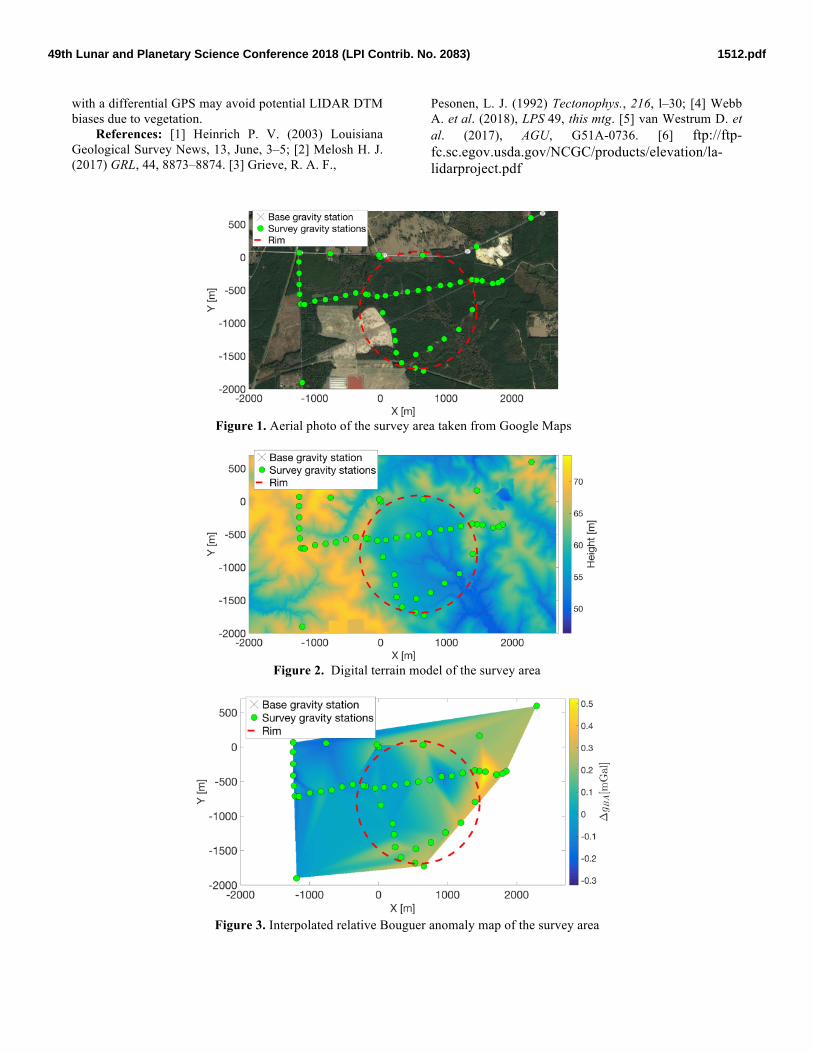
Introduction: The Brushy Creek feature is a proposed impact crater 52 km northeast of Baton Rouge in Louisiana’s St. Helena county just south of Route 37. It has been suspected to be an impact feature since shock-metamorphosed quartz was found at the feature [1], although such features are no longer considered to be incontrovertible indicators of an impact event [2]. Another piece of evidence that supports the impact hypothesis is the quasi-circular topographic feature reminiscent of a crater rim with a diameter of ~1.8 km, demarcated by the dashed red circle in Fig. 1. To our knowledge, there has not been a ground-based gravity survey of the Brushy Creek feature. The fracturing of the subsurface material due to the propagation of the impact shock wave is expected to produce a 1-10 mGal negative Bouguer gravity signature in the center of a crater of this size [3]. This field work was performed concurrently with a ground-penetrating-radar survey ([4], this mtg.), and the goal of both efforts was to find evidence either for or against an impact origin.
Survey methodology: We used the Scintrex CG-6 Autograv relative gravimeter to collect the gravity data in this work. The observation time at each station was 60 seconds with 1 Hz reading frequency. Prior testing of the CG-6 indicates that it is significantly less susceptible to tares and that it better reproduces repeated measurements than previous gravimeter models [5]. In the course of our own field work, the standard deviation of the mean was typically between 10 and 15 µGal.
There are multiple roads that traverse the Brushy Creek feature. One east-west trending dirt road (see Fig. 1) goes close to the center of the feature from rim to rim. This road was the main target of our observations with the highest density of gravity stations. Additional measurements in the surrounding area were collected where feasible, but the survey was ultimately limited by the accessibility of the terrain.
Since we used a relative gravimeter without referencing our measurements to a point with known absolute gravity, we can only compute a relative Bouguer anomaly. The relative Bouguer anomaly is set to be zero at an arbitrary point, which is our base station. The first and last measurements were done at the base station to correct for a possible residual drift of the gravimeter. The positions of the gravity stations were measured by the gravimeter’s GPS receiver.
Data reductions: We used the standard gravity data reduction methodology to compute gravity anomalies. The tidal and drift corrections were done automatically by the gravimeter. The relative free-air anomaly was computed as follows:
Δ𝑔!",! = (Δ𝑔!"#,! − Δ𝑔!"#,!) − (𝛾 𝜑! − 𝛾 𝜑! )
+𝑑𝑔𝑑𝑟
(𝐻! − 𝐻!), where Δ𝑔!"# is the observed relative gravity, 𝛾 𝜑 is the normal gravity computed using the Somigliana’s formula, !"!"
is the vertical gravity gradient equal to 0.3086 mGal/m, H is the height with respect to the reference ellipsoid. The indices i and 0 refer to a survey gravity station and the base gravity station, respectively.
The relative Bouguer anomaly is then computed as follows:
Δ𝑔!",! = Δ𝑔!",! − 2𝜋𝐺𝜚(𝐻! − 𝐻!), where 𝜚 is the crustal density. The crustal density is an unknown parameter. It can be either assumed to be equal to the mean crustal density or can be found by decorrelating the Bouguer anomaly with elevation. We have estimated the crustal density to be ~1900 kg/m3.
The elevation data was taken from the publicly available Louisiana’s statewide LIDAR project. The LIDAR systems used in the Louisiana project were accurate to 15-30 cm in root mean square error [6]. The data were georeferenced in the UTM Zone 15 projection and placed on the NAD 83 (horizontal) and NAVD 88 (vertical) datum. Obstructions and vegetation were removed in post-processing of the LIDAR returns [6].
Results: Using the LIDAR DTM, the range of heights at the gravity stations is 18 meters (Fig. 2). The range of the free-air anomaly is 1.4 mGals. After applying the Bouguer correction, the range of the anomaly reduces to 0.8 mGal. Terrains in the field area were never sloped more than approximately 5º within the area of the survey, which justifies the use of a simple Bouguer slab formula.
We have produced an interpolated map of the relative Bouguer anomaly (Fig. 3). The general trend is a westward decrease of the Bouguer anomaly. We have not found the expected negative anomaly centered at the feature. The upper bound on the central Bouguer anomaly is 0.2 mGal. There was also not observable jump in gravity associated with the locations of the proposed rim structure. It is possible that an impact into the somewhat unconsolidated clays present at Brushy Creek would not produce an observable Bouguer anomaly (unlike what is observed at similarly sized craters), but our results do not provide support for the hypothesis that the Brushy Creek feature has an impact origin.
Opportunities for future work: Due to the capabilities of the CG-6 gravimeter, the accuracy of the measured Bouguer anomaly was ultimately limited by uncertainty in the elevation: 10 cm of elevation error would produce a larger gravity offset than the nominal precision of the gravimeter. Consequently, a field survey
1512.pdf49th Lunar and Planetary Science Conference 2018 (LPI Contrib. No. 2083)
with a differential GPS may avoid potential LIDAR DTM biases due to vegetation.
References: [1] Heinrich P. V. (2003) Louisiana Geological Survey News, 13, June, 3–5; [2] Melosh H. J. (2017) GRL, 44, 8873–8874. [3] Grieve, R. A. F.,
Pesonen, L. J. (1992) Tectonophys., 216, l–30; [4] Webb A. et al. (2018), LPS 49, this mtg. [5] van Westrum D. et al. (2017), AGU, G51A-0736. [6] ftp://ftp-fc.sc.egov.usda.gov/NCGC/products/elevation/la-lidarproject.pdf
Figure 1. Aerial photo of the survey area taken from Google Maps
Figure 2. Digital terrain model of the survey area
Figure 3. Interpolated relative Bouguer anomaly map of the survey area
1512.pdf49th Lunar and Planetary Science Conference 2018 (LPI Contrib. No. 2083)