![NEW FEATURES - MicroSurveys3.microsurvey.com/fieldgenius/FieldGenius9/9.0/ReleaseNotes.pdf · This is similar to the “Helmerts” functionality in MicroSurvey CAD. [F3051] Menu](https://static.fdocuments.net/doc/165x107/5bc715df09d3f22f508d406d/new-features-this-is-similar-to-the-helmerts-functionality-in-microsurvey.jpg)
Introducing MicroSurvey embeddedCAD 2018 and...
32
Confidential 1 Introducing MicroSurvey embeddedCAD 2018 and inCAD 2018 Using embeddedCAD to Accomplish Cadastral Tasks Quickly and Efficiently May 18 th , 2017
Transcript of Introducing MicroSurvey embeddedCAD 2018 and...

Confidential1
Introducing MicroSurvey
embeddedCAD 2018 and inCAD 2018
Using embeddedCAD to Accomplish Cadastral Tasks
Quickly and Efficiently
May 18th, 2017

Confidential2
Presenters
James Thomas
Technical Support
James Johnston
Training & Support Manager
Brian Brown
BCLS
Guest Speaker

Confidential3
1. embeddedCAD vs. inCAD Overview
a) Features & Benefits
2. Licensing Options & Pricing
3. MS Features + Surfacing Demo
4. Guest Speaker – Brian Brown, BCLS
5. MicroSurvey Support / Training
6. Questions
Today’s Agenda

Confidential4
Why are you interested in embeddedCAD or inCAD?
You may choose more than one answer
Submit answers through the GoToWebinar interface
Viewer Poll

Confidential5
embeddedCAD vs. inCADWhat’s the difference?
powered by
AutoCAD OEM 2018 EngineInstalls as a plugin for
Civil3D 2018
AutoCAD 2018
AutoCAD Map3D 2018
Stand-Alone Software Solution
(no AutoCAD license required)
Plugin for your existing AutoCAD software
(Require separate AutoCAD license)
New Customizable Ribbon Menus
Identical Microsurvey features
Routine releases to keep up with your version of AutoCAD

Confidential6
Why embeddedCAD?
• Ease of use and quick transition
• Existing AutoCAD operators will discover a familiar environment
• Familiar visual layout
• Easy transition from other Autodesk platforms
• Common commands – Contains all of the AutoCAD OEM commands
plus MicroSurvey features
• Economical CAD Option
• Perpetual licenses – no subscription required!
• Annual Maintenance Plans optional
• Cross-grade pricing for existing Microsurvey CAD users
• Powerful Geospatial Tools
• Survey specific features not offered in AutoCAD
• COGO functions, coordinate transformation, traverse routines
• Import and export field data
• Trusted AutoCAD name powering your software
• Supports recently updated 2018 .DWG format
• No conflicts with other departments or clients using Autodesk products
• Object Enabler compatible
• Accepts AutoCAD files - 100% .dwg compatible
Supports Leica DBX import from Captivate

Confidential7
What does inCAD offer if I already use AutoCAD or Civil3D?
• Survey specific features
• Improve upon your AutoCAD or Civil 3D experience with
MicroSurvey tools
• Import and export field data
• No need for multiple software packages
• No hassle of switching platforms
• Simplify your workflows
• Save time spent on converting data formats and moving files
• Complete survey calculation and drafting solution under one roof
• Installs as a plugin for:
• AutoCAD 2018
• Civil 3D 2018
• AutoCAD Map 3D 2018

Confidential8
Pricing & Perpetual Licensing
2400
4800
7200
9600
12000
1400
2800
4200
5600
7000
29953590
41854780
5375
Year 1 Year 2 Year 3 Year 4 Year 5
2400/year 1400/year emCAD
Approx. cumulative
investment over 5 years
Not interested in subscription services?
We offer perpetual licensing
• Own what you buy
• Update at anytime
• 3 months of maintenance included
inCAD 2018 Standard $1,495 $295
inCAD 2018 Premium $1,995 $395
InCAD 2018 MSRP AMS /yr
embeddedCAD 2018 Standard $2,495 $495
embeddedCAD 2018 Premium $2,995 $595
embeddedCAD 2018 MSRP AMS /yr
Premium License offers:
• Site design, pad design, road design & alignments
• 3D modelling features, TIN, surfacing, contours
• For more details visit microsurvey.com/products/compare.htm
Optional Annual Maintenance

Confidential9
Features - COGO
• Fast – Efficient – Flexible
• Enter quickly from the command line
• One hand on the key board one on the plan
• Functions:
• New Point
• Traverse
• Inverse
• Turned angles
• Deflection angles
• Curve Inverse
• Curve entry
• Baseline Offset
• Three Point Angle
• Perpendicular tie calculation
• Bearing/Bearing Int. with Offsets
• Bearing/Distance Int. with Offsets
• Distance/Distance Int. with Offset
• Distance/Angle Int. with Offsets
• Record Batch COGO to save
time on repetitive calc’s
• Optional Graphical Interface
• Curve Calculator Options

Confidential10
Features - Field Data Import/Export Options
• Streamlined import tools for many field products
• Leica DBX compatible (Captivate/Viva users)
• ASCII Import/Export
• FieldGenius Import/Export + many other field products
• Active Traverse Editor & Active Coordinate Editor
• Spreadsheet style list of points/coordinates stored in the database
• Updates instantly reflected within the drawing
• Review observation information from your traverse
• Make changes, fix blunders, etc.
• Field-to-Finish with AutoMap
• Automated layering, symbols, linework etc.
• Customizable to work with your existing field codes
• Also supports XYZ, SDR and AIMS coding

Confidential11
Features – Surfacing & DTMs
• Contours
• TIN / Grid / Triangulated Grid
• Compute Volumes
• Compare Surfaces
• Import/Export LandXML for other CAD or
field products

Confidential12
Brian Brown, BCLSCurrent President of ABCLS
Project Land Surveyor
McElhanney Associates Land Surveying Ltd.
www.mcelhanney.com
Whistler BC
A comparison to illustrate the impact
MicroSurvey’s surveyor friendly tools can
have when added to a regular CAD workflow

Confidential13
Stonebridge Drive Subdivision, Road Allocation and
Later Re-Subdivision
Pure CAD will be sufficient when a project
is simple. MicroSurvey embeddedCAD’s
strengths are apparent when you
investigate a complex, multi stage project.

Confidential14
Stonebridge Drive
Whistler, B.C.

Confidential15
Background: LMP 41222 February 1999 Subdivision by Bunbury & Associates
• 30 Lot
Subdivision
• Plan produced
on a short
time line
• Roads not
constructed
Confidential16
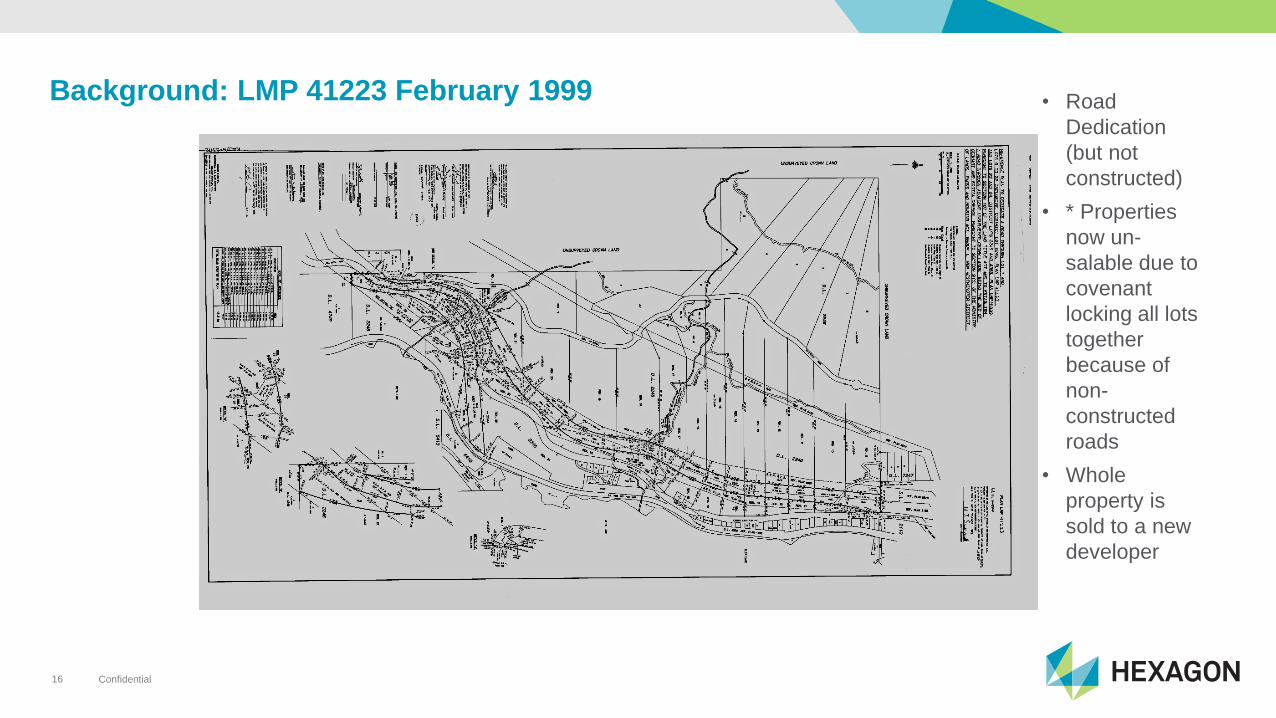
Background: LMP 41223 February 1999 • Road
Dedication
(but not
constructed)
• * Properties
now un-
salable due to
covenant
locking all lots
together
because of
non-
constructed
roads
• Whole
property is
sold to a new
developer

Confidential17
BCP 1932 October 2001
• Road
Exchanges
are required
• Many
complex
exchanges
required
• Many details
Challenge: Calculating Areas for many exchanges, and ensuring that all required dimensions are correct and included.
MicroSurvey Solution: The Lot Closure Routine walks you through each exchange and uses labels from your drawing.

Confidential18
Using the Lot Closure Tool
• Allows calculation of areas and closure
• Allows you to pick dimensions from the drawing
• Provides an accurate check of annotations
• Checks that annotations are complete
• Provides a written summary

Confidential19
BCP 1933 Page 1 December 2001
• New lots
computed
after access
redesigned
Challenge: A Multitude of labeling settings are required for grid to ground scaling and differing lineweights.
MicroSurvey Solution: Project Labeling Defaults eases styles definition and access.
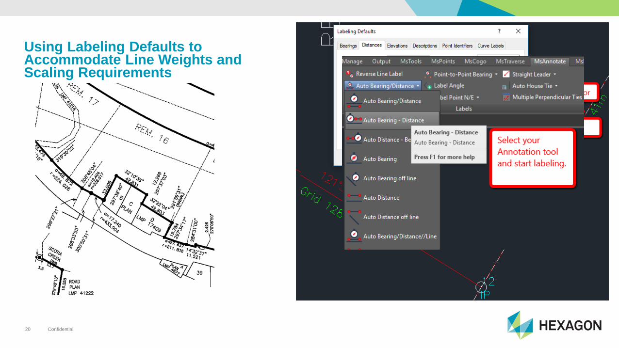
Confidential20
Using Labeling Defaults to Accommodate Line Weights and Scaling Requirements

Confidential21
BCP 1933 Page 1 December 2001
• Note complex
Title section
reflecting road
allowance
exchanges
• Multiple tables
are used to
communicate
information
Challenge: Creation of tables can be a long, manual Process with a CAD program.
MicroSurvey Solution: Create tables right from the project database

Confidential22
Creating a Multi-ties Table
• One of several convenient Table Building tools
• Create Tables from points stored in database
• Line Tables, Curve Tables, Coordinate Tables, Description Tables, Lot Tables

Confidential23
BCP 1933 Page 2 March 2004
• Next Plan
shows final
monumentation
set
Challenge: Inserting and trimming multiple symbols
MicroSurvey Solution: AutoMap links symbols to the database and trims linework

Confidential24
Setting AutoMap to match Field Codes to Drafting Standards

Confidential25
Example 1: Symbol Insertion

Confidential26
Example 2: Symbol Insertion

Confidential27
Other Capabilities:
• Input/Output scales for labeling and computation with mixed
Ground/Grid information
• Geodetic Tools
• Traverse Editing and Adjustment
• Area Computation Tools
• Lot Creation Tools

Confidential28
The Result:

Confidential29
After you purchase we are here for you!
• Need help?
• First class technical support
• Phone
• Visit us in the sunny Okanagan Valley?
• Helpdesk
• Articles
• Movies
• User Forum
• Training classes
• Attend from the comfort of your office
• Trainers located across North America
Value Added – The MicroSurvey Advantage

Confidential30
What to expect in the future.
• We listen to you
• Improvements driven by user feedback
• Feature requests from users
• Defect reporting used to continuously improve our
software
• Try before you buy
• Download a free demo at microsurvey.com
• Optional Annual Maintenance Program
• Stay up-to-date with each new release
• Keep your old version installed
• Current licenses valid for most previous versions
• Bing Maps import - coming soon!
Field Data Collection Software
Supports over 20 hardware
manufactures
Advanced Least Squares
Adjustment Package
Converters for seamless field
data import
Complete IntelliCAD powered
CAD solution
Supports scanning and point
cloud processing
Explore our other products

Confidential31
Would you like to be contacted by MicroSurvey to learn more
about the products discussed today?
Final Poll (Private)

Confidential32
Questions?