Interpretation - GW · Web viewCoastal management Interpretation If an activity is covered by more...
85
5.7 Coastal management Interpretation If an activity is covered by more than one rule, then the rule that applies is the rule that is more specific for the relevant activity, area or resource, rather than a more general rule . This does not apply w W here a proposal includes a number of activities which trigger separate specific rules. In that case , all of the relevant rules are considered when assessing the proposal. An activity needs to comply with all relevant rules in the Plan, including those in the whaitua Chapters 7 – 11. For the purposes of these rules, ‘water’ means both fresh water and coastal water. As noted in Section 2.1 P provisions relevant to the coastal marine area are identified by this icon . Under section 86B of the Resource Management Act 1991 all rules have immediate legal effect from 31 July 2015. The associated definitions, schedules and maps applicable to those rules also have immediate legal effect. The following table is intended as a guide only and does not form part of the Plan. Refer to specified rules for detailed requirements. Code Activity status P Permitted C Controlled RD Restricted discretionary D Discretionary NC Non-complying Pr Prohibited PROPOSED NATURAL RESOURCES PLAN FOR THE WELLINGTON REGION DECISION VERSION (31.07.2019)) 233
Transcript of Interpretation - GW · Web viewCoastal management Interpretation If an activity is covered by more...
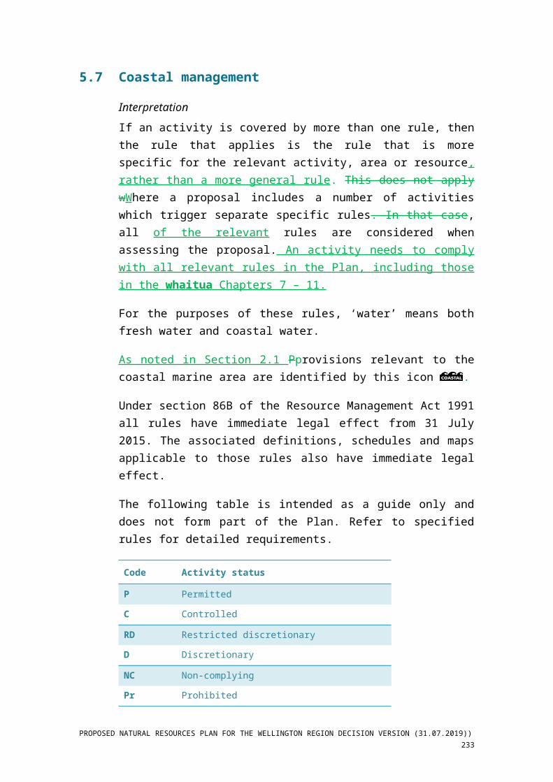
5.7 Coastal management
InterpretationIf an activity is covered by more than one rule, then the rule that applies is the rule that is more specific for the relevant activity, area or resource, rather than a more general rule. This does not apply wWhere a proposal includes a number of activities which trigger separate specific rules. In that case, all of the relevant rules are considered when assessing the proposal. An activity needs to comply with all relevant rules in the Plan, including those in the whaitua Chapters 7 – 11.
For the purposes of these rules, ‘water’ means both fresh water and coastal water.
As noted in Section 2.1 Pprovisions relevant to the coastal marine area are identified by this icon .
Under section 86B of the Resource Management Act 1991 all rules have immediate legal effect from 31 July 2015. The associated definitions, schedules and maps applicable to those rules also have immediate legal effect.
The following table is intended as a guide only and does not form part of the Plan. Refer to specified rules for detailed requirements.
Code Activity status
P Permitted
C Controlled
RD Restricted discretionary
D Discretionary
NC Non-complying
Pr Prohibited
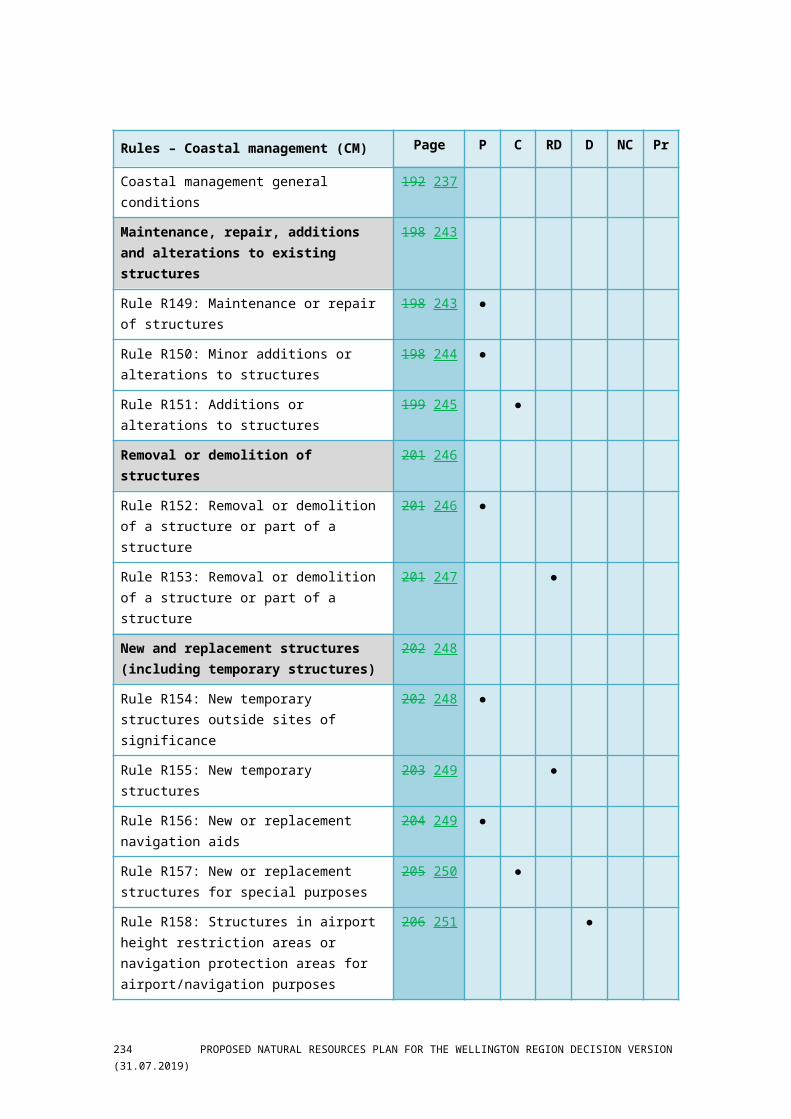
Rules – Coastal management (CM) Page P C RD D NC Pr
Coastal management general conditions 192 237
Maintenance, repair, additions and alterations to existing structures
198 243
Rule R149: Maintenance or repair of structures 198 243 ●
Rule R150: Minor additions or alterations to structures 198 244 ●
Rule R151: Additions or alterations to structures 199 245 ●
PROPOSED NATURAL RESOURCES PLAN FOR THE WELLINGTON REGION DECISION VERSION (31.07.2019)) 233
Rules – Coastal management (CM) Page P C RD D NC Pr
Removal or demolition of structures 201 246
Rule R152: Removal or demolition of a structure or part of a structure
201 246 ●
Rule R153: Removal or demolition of a structure or part of a structure
201 247 ●
New and replacement structures (including temporary structures)
202 248
Rule R154: New temporary structures outside sites of significance
202 248 ●
Rule R155: New temporary structures 203 249 ●
Rule R156: New or replacement navigation aids 204 249 ●
Rule R157: New or replacement structures for special purposes
205 250 ●
Rule R158: Structures in airport height restriction areas or navigation protection areas for airport/navigation purposes
206 251 ●
Rule R159: Structures in airport height restriction areas or navigation protection areas
206 252 ●
Rule R160: Structures and disturbance associated with motor vehicles inside the Cook Strait Cable Protection Zone
207 252 ●
Rule R161: New structures, additions or alterations to structures outside sites of significance
207 253 ●
Rule R162: New structures, additions or alterations to structures inside sites of significance
207 253 ●
Rule R163: Replacement of structures or parts of structures
208 254 ●
Rule R164: Replacement of structures or parts of structures
209 254 ●
Seawalls 209 255
Rule R165: Additions or alterations to, or replacements of, existing seawalls
209 255 ●
Rule R166: Seawalls outside sites of significance 210 256 ●
Rule R167: Seawalls inside sites of significance 211 256 ●
Heritage structures 211 257
Rule R168: Maintenance or repair or A a lteration to structures identified in Schedule E2 or Schedule E3
211 257 ●
Rule R169: Additions or alterations to structures identified in Schedule E1 or Schedule E2
212 258 ●
234 PROPOSED NATURAL RESOURCES PLAN FOR THE WELLINGTON REGION DECISION VERSION (31.07.2019)

Rules – Coastal management (CM) Page P C RD D NC Pr
Rule R170: Additions to structures identified in Schedule E3
213 259 ●
Rule R171: Additions or alterations to structures identified in Schedule E1, Schedule E2 or Schedule E3
213 259 ●
Rule R172: Removal, demolition or replacement of structures or parts of structures identified in Schedule E1, Schedule E2 or Schedule E3
214 260 ●
Structures in the Commercial Port Area 214 260
Rule R173: Maintenance or repair or A a lteration or alterations to structures inside the Commercial Port Area
214 260 ●
Rule R174: Maintenance or repair or A a lteration or alterations to structures inside the Commercial Port Area
215 261 ●
Rule R175: New structures associated with passenger and cargo handling inside the Commercial Port Area
215 262 ●
Boatsheds and swing moorings 216 262
Rule R176: Use of boatsheds 216 262 ●
Rule R177: Change of use of boatsheds 216 262 ●
Rule R178: New boatsheds inside Boatshed Management Areas
216 263 ●
Rule R179: New boatsheds outside Boatshed Management Areas
217 263 ●
Rule R180: New sSwing moorings inside Mooring Areas
217 263 ●
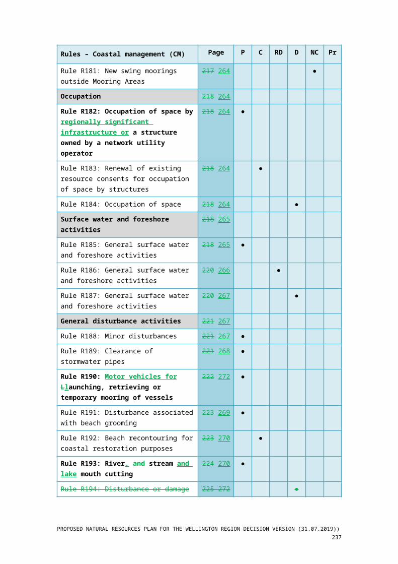
Rule R181: New swing moorings outside Mooring Areas
217 264 ●
Occupation 218 264
Rule R182: Occupation of space by regionally significant infrastructure or a structure owned by a network utility operator
218 264 ●
Rule R183: Renewal of existing resource consents for occupation of space by structures
218 264 ●
Rule R184: Occupation of space 218 264 ●
Surface water and foreshore activities 218 265
Rule R185: General surface water and foreshore activities
218 265 ●
Rule R186: General surface water and foreshore activities
220 266 ●
Rule R187: General surface water and foreshore activities
220 267 ●
PROPOSED NATURAL RESOURCES PLAN FOR THE WELLINGTON REGION DECISION VERSION (31.07.2019)) 235

Rules – Coastal management (CM) Page P C RD D NC Pr
General disturbance activities 221 267
Rule R188: Minor disturbances 221 267 ●
Rule R189: Clearance of stormwater pipes 221 268 ●
Rule R190: Motor vehicles for Llaunching, retrieving or temporary mooring of vessels
222 272 ●
Rule R191: Disturbance associated with beach grooming
223 269 ●
Rule R192: Beach recontouring for coastal restoration purposes
223 270 ●
Rule R193: River, and stream and lake mouth cutting
224 270 ●
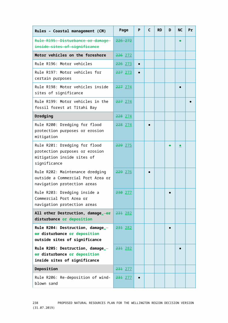
Rule R194: Disturbance or damage 225 272 ●
Rule R195: Disturbance or damage inside sites of significance
226 272 ●
Motor vehicles on the foreshore 226 272
Rule R196: Motor vehicles 226 273 ●
Rule R197: Motor vehicles for certain purposes 227 273 ●
Rule R198: Motor vehicles inside sites of significance 227 274 ●
Rule R199: Motor vehicles in the fossil forest at Tītahi Bay
227 274 ●
Dredging 228 274
Rule R200: Dredging for flood protection purposes or erosion mitigation
228 274 ●
Rule R201: Dredging for flood protection purposes or erosion mitigation inside sites of significance
229 275 ● ●
Rule R202: Maintenance dredging outside a Commercial Port Area or navigation protection areas
229 276 ●
Rule R203: Dredging inside a Commercial Port Area or navigation protection areas
230 277 ●
All other Destruction, damage, or disturbance or deposition
231 282
Rule R204: Destruction, damage, or disturbance or deposition outside sites of significance
231 282 ●
Rule R205: Destruction, damage, or disturbance or deposition inside sites of significance
231 282 ●
Deposition 231 277
Rule R206: Re-deposition of wind-blown sand 231 277 ●
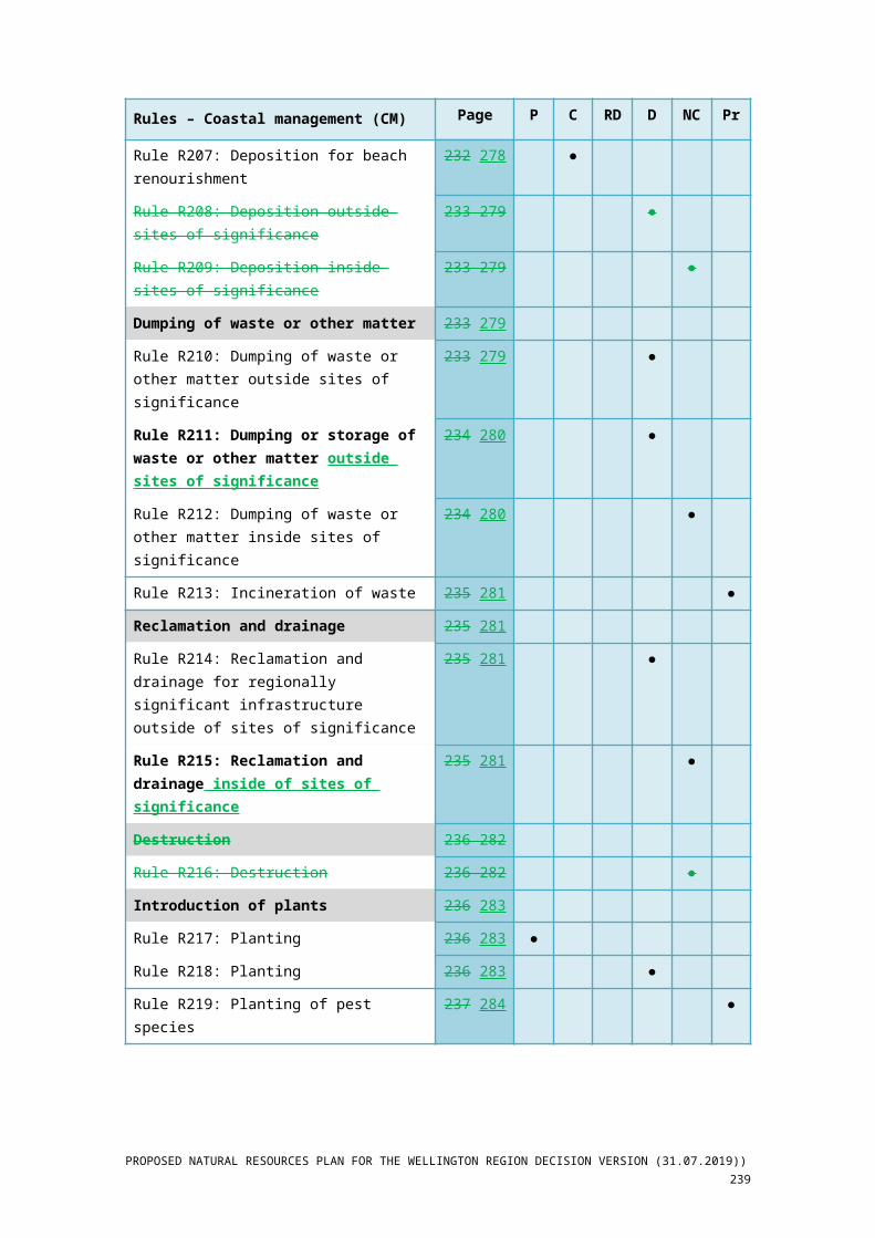
Rule R207: Deposition for beach renourishment 232 278 ●
Rule R208: Deposition outside sites of significance 233 279 ●
236 PROPOSED NATURAL RESOURCES PLAN FOR THE WELLINGTON REGION DECISION VERSION (31.07.2019)
Rules – Coastal management (CM) Page P C RD D NC Pr
Rule R209: Deposition inside sites of significance 233 279 ●
Dumping of waste or other matter 233 279
Rule R210: Dumping of waste or other matter outside sites of significance
233 279 ●
Rule R211: Dumping or storage of waste or other matter outside sites of significance
234 280 ●
Rule R212: Dumping of waste or other matter inside sites of significance
234 280 ●
Rule R213: Incineration of waste 235 281 ●
Reclamation and drainage 235 281
Rule R214: Reclamation and drainage for regionally significant infrastructure outside of sites of significance
235 281 ●
Rule R215: Reclamation and drainage inside of sites of significance
235 281 ●
Destruction 236 282
Rule R216: Destruction 236 282 ●
Introduction of plants 236 283
Rule R217: Planting 236 283 ●
Rule R218: Planting 236 283 ●
Rule R219: Planting of pest species 237 284 ●
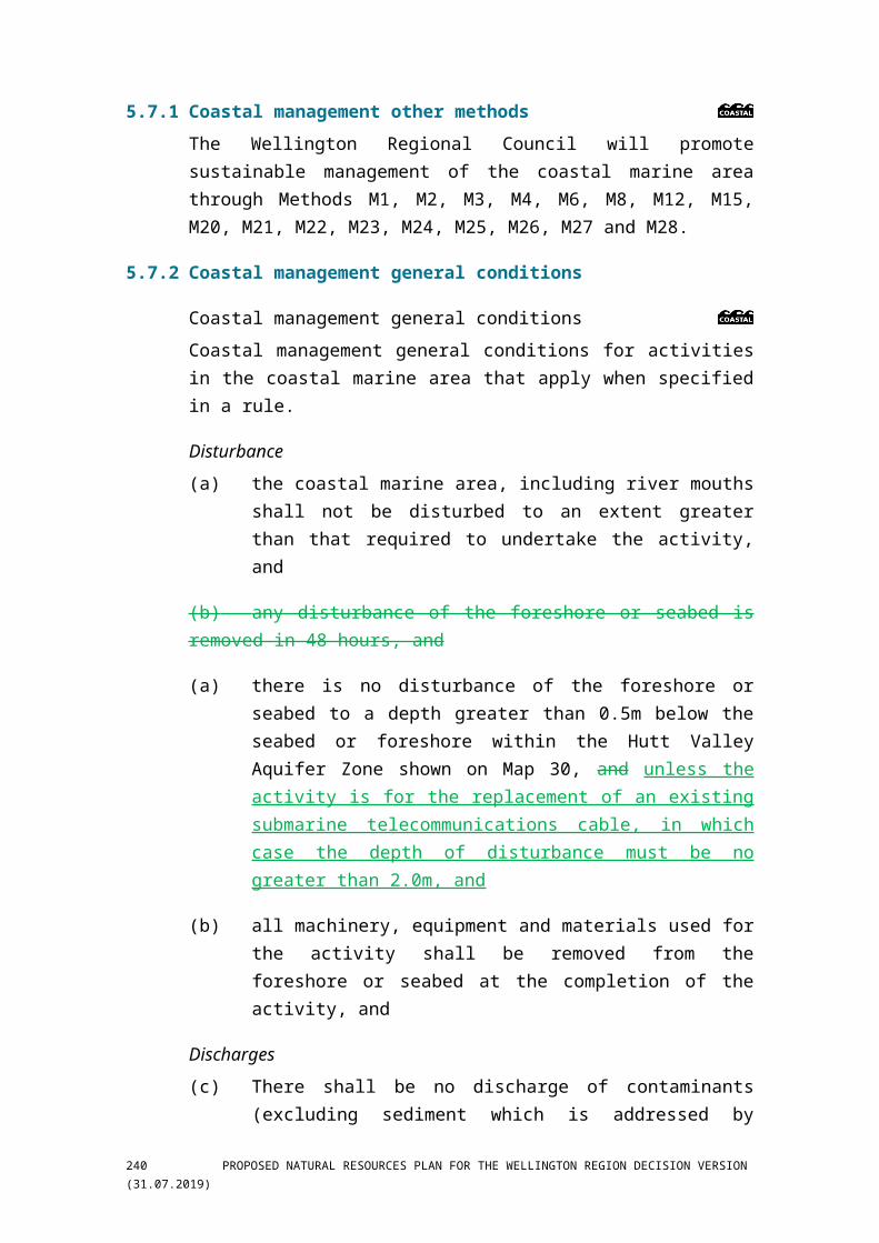
5.7.1 Coastal management other methods The Wellington Regional Council will promote sustainable management of the coastal marine area through Methods M1, M2, M3, M4, M6, M8, M12, M15, M20, M21, M22, M23, M24, M25, M26, M27 and M28.
5.7.2 Coastal management general conditions
Coastal management general conditions Coastal management general conditions for activities in the coastal marine area that apply when specified in a rule.
Disturbance(a) the coastal marine area, including river mouths shall not be disturbed
to an extent greater than that required to undertake the activity, and
(b) any disturbance of the foreshore or seabed is removed in 48 hours, and
(c) there is no disturbance of the foreshore or seabed to a depth greater than 0.5m below the seabed or foreshore within the Hutt Valley
PROPOSED NATURAL RESOURCES PLAN FOR THE WELLINGTON REGION DECISION VERSION (31.07.2019)) 237
Aquifer Zone shown on Map 30, and unless the activity is for the replacement of an existing submarine telecommunications cable, in which case the depth of disturbance must be no greater than 2.0m, and
(d) all machinery, equipment and materials used for the activity shall be removed from the foreshore or seabed at the completion of the activity, and
Discharges (e) There shall be no discharge of contaminants (excluding sediment
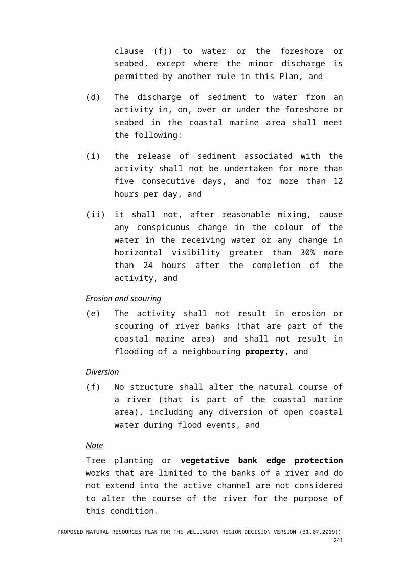
which is addressed by clause (f)) to water or the foreshore or seabed, except where the minor discharge is permitted by another rule in this Plan, and
(f) The discharge of sediment to water from an activity in, on, over or under the foreshore or seabed in the coastal marine area shall meet the following:
(i) the release of sediment associated with the activity shall not be undertaken for more than five consecutive days, and for more than 12 hours per day, and
(ii) it shall not, after reasonable mixing, cause any conspicuous change in the colour of the water in the receiving water or any change in horizontal visibility greater than 30% more than 24 hours after the completion of the activity, and
Erosion and scouring(g) The activity shall not result in erosion or scouring of river banks (that
are part of the coastal marine area) and shall not result in flooding of a neighbouring property, and
Diversion(h) No structure shall alter the natural course of a river (that is part of the
coastal marine area), including any diversion of open coastal water during flood events, and
NoteTree planting or vegetative bank edge protection works that are limited to the banks of a river and do not extend into the active channel are not considered to alter the course of the river for the purpose of this condition.
(i) Any diversion of open coastal water undertaken as part of an activity shall only be temporary and for a period no longer than that required to complete the activity. All work shall be contained within the coastal
238 PROPOSED NATURAL RESOURCES PLAN FOR THE WELLINGTON REGION DECISION VERSION (31.07.2019)
marine area, and any diversion channel required must have sufficient capacity to carry the same flow as the original channel, so as not to cause flooding or erosion of any neighbouring property, and
Dumping(j) Demolition materials shall not be used for any purpose in the coastal
marine area, and
Fish passage(k) Any structure constructed in the coastal marine area shall not impede
provide for fish passage between coastal and fresh water habitat (including between fresh water and coastal water) at all times, unless a temporary restriction is required for construction activities, and
Inanga spawning(l) In any part of the coastal marine area (including any part of a river in
the coastal marine area) identified as inanga spawning habitat in Schedule F1b (inanga spawning habitat), no disturbance of or deposition in, on or under the foreshore or seabed shall occur and no diversion of open coastal water or sediment discharge shall occur between 1 March January and 31 May, and
Design and maintenance of structures(m) Any structure (other than stormwater network structures) shall be
designed and maintained so that it does not reduce the ability of the river (that is part of the coastal marine area) to convey flood flows, including the management of flood debris accumulated against the structure, and
Refuelling(n) No refuelling or cleaning of equipment shall take place on the
foreshore or seabed in the coastal marine area (excluding vessels in the Commercial Port Area), and fuel storage shall not occur at a location where fuel can enter coastal water, and
Lighting and glare(o) All exterior lighting shall be managed to avoid the spill of light or
glare that is:
(i) a hazard to traffic safety on streets outside the coastal marine area, and
(ii) a hazard to navigation in the coastal marine area,
unless the lighting is necessary for public safety reasons or operational requirements, and
PROPOSED NATURAL RESOURCES PLAN FOR THE WELLINGTON REGION DECISION VERSION (31.07.2019)) 239
Noise in the coastal marine area(p) Noise from activities located outside the Commercial Port Area
shown on Map 32, Map 33 and Map 34 and the Lambton Harbour Area (Northern Zone) shown on Map 32 in the coastal marine area shall meet the following noise standards:
(i) the activity shall not cause excessive noise (defined in section 326 of the Resource Management Act 1991) outside the coastal marine area, and
(ii) between the hours of 7.00am and 11.00pm, the noise level (Leq) measured at any point on the nearest Residential Area boundary shall not exceed 55dB(A), and
(iii) between the hours of 11.00pm and 7.00am, the noise level (Leq) measured at any point on the nearest Residential Area boundary shall not exceed 45dB(A), and
(iv) single events of noise shall not exceed an Lmax sound level of 75dB(A), and
(v) noise shall be measured and assessed in accordance with NZS 6802:2008 Acoustics – Environmental Noise, and
(vi) any construction activities shall meet standards specified in Table 1 of NZS 6803:1999 Acoustics – Construction Noise, and
(vii) helicopter landing areas shall meet the standards specified for residential areas in Table 1 of NZS 6807:1994 Noise management and land use planning for helicopter landing areas, and
conditions (i) to (iv) shall not apply to the following:
(viii) noise generated by navigational aids, safety signals, warning devices, or emergency pressure relief valves, or
(ix) noise generated by emergency work arising from the need to protect life or limb or prevent loss or serious damage to property or minimise or prevent environmental damage, or
(x) commercial firework displays, and
conditions (ii) to (iv) shall not apply to temporary military training activities undertaken for defence purposes. Noise emission as a result of temporary military training measured on a line 20m from and
240 PROPOSED NATURAL RESOURCES PLAN FOR THE WELLINGTON REGION DECISION VERSION (31.07.2019)
parallel to the facade of any dwelling used for accommodation or the legal boundary where this is closer to the dwelling or building shall meet the following:
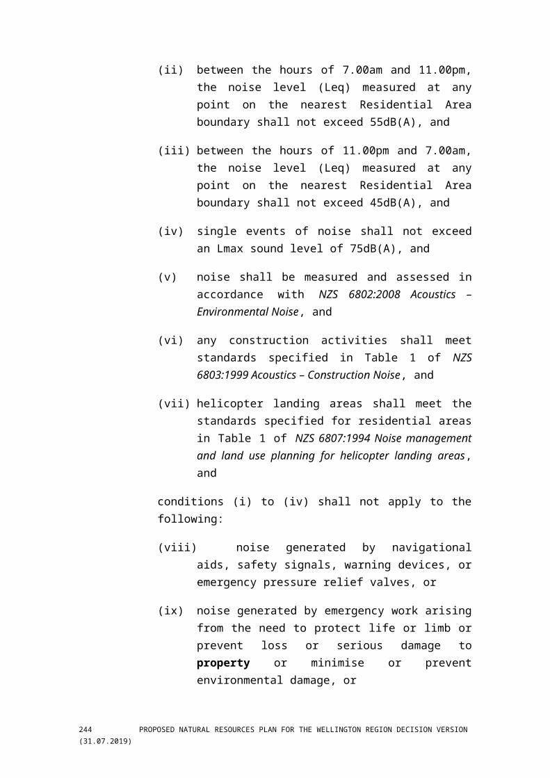
(xi) for all activities excluding the use of explosives:
Time (any day) Limits (dB(A))
Leq Lmax
0000 – 0630
0630 – 0730
0730 – 1800
1800 – 2000
2000 – 2400
45
60
75
70
45
75
75
90
85
75
(xii) for activities involving the use of explosives: 122dB(C) during daylight hours, and
(q) Noise from port-related activities located within the Commercial Port Area shown on Map 32, Map 33 and Map 34 and the Lambton Harbour Area (Northern Zone) shown on Map 32 shall comply with the following noise standards:
(i) the activity shall not cause excessive noise (defined in section 326 of the Resource Management Act 1991) outside the coastal marine area, and
(ii) noise shall be measured in accordance with the requirements of NZS 6801:2008 Acoustics – Measurement of environmental sound and NZS 6809:1999 Port noise management and land use planning, and
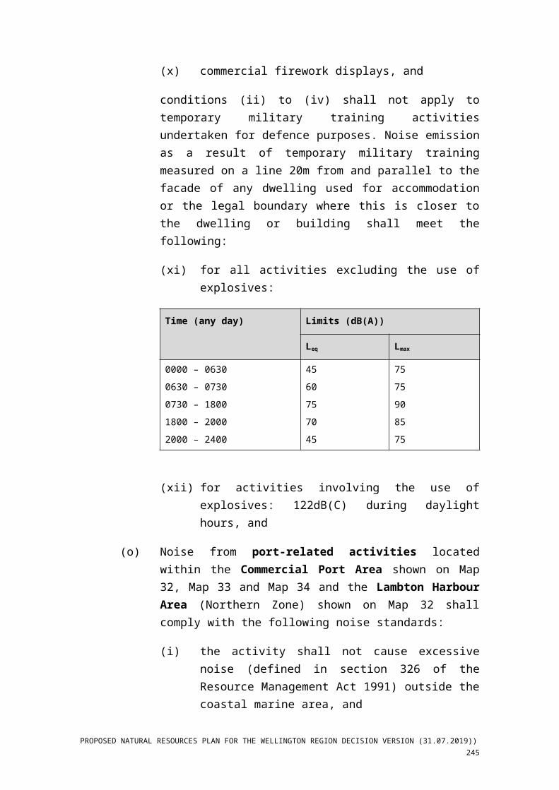
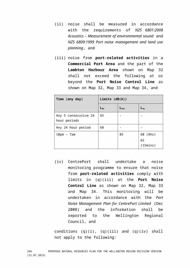
(iii) noise from port-related activities in a Commercial Port Area and the part of the Lambton Harbour Area shown on Map 32 shall not exceed the following at or beyond the Port Noise Control Line as shown on Map 32, Map 33 and Map 34, and
Time (any day) Limits (dB(A))
Ldn Lmax Leq
Any 5 consecutive 24 hour periods 65 - -
Any 24 hour period 68 - -
PROPOSED NATURAL RESOURCES PLAN FOR THE WELLINGTON REGION DECISION VERSION (31.07.2019)) 241

Time (any day) Limits (dB(A))
Ldn Lmax Leq
10pm – 7am 85 60 (9hr)
65 (15mins)
(iv) CentrePort shall undertake a noise monitoring programme to ensure that noise from port-related activities comply with limits in (q)(iii) at the Port Noise Control Line as shown on Map 32, Map 33 and Map 34. This monitoring will be undertaken in accordance with the Port Noise Management Plan for CentrePort Limited (Dec 2008) and the information shall be reported to the Wellington Regional Council, and
conditions (q)(i), (q)(iii) and (q)(iv) shall not apply to the following:
(v) noise generated by navigational aids, safety signals, warning devices or emergency pressure relief valves, and
(vi) noise generated by emergency work arising from the need to protect life or limb or prevent loss or serious damage to property or minimise or prevent environmental damage, and
(vii) noise generated by construction activities which shall meet the standards specified in Table 1 of NZS 6803:1999 Acoustics – Construction Noise, and
(viii) noise generated by helicopter landing areas which shall meet the standards specified for commercial areas in Table 1 of NZS 6807:1994 Noise management and land use planning for helicopter landing areas, and
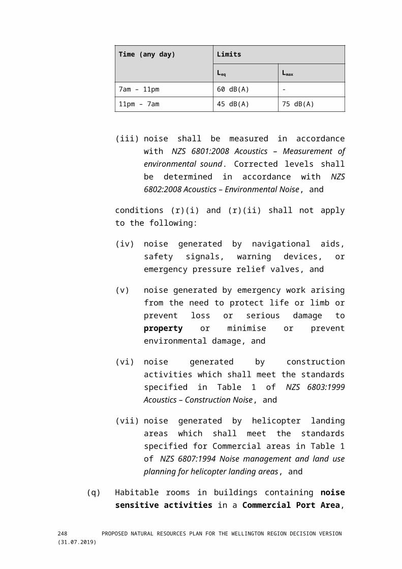
(r) The following noise standards shall only apply to activities in the Commercial Port Area at Seaview Wharf shown on Map 34 that are controlled by a rule in this Plan, are located in the coastal marine area and refer to the coastal marine area general conditions within the rule:
(i) the activity shall not cause excessive noise (defined in section 326 of the Resource Management Act 1991) outside the coastal marine area at the nearest residential area boundary, and
(ii) the noise level measured at any point on the nearest residential area boundary shall not exceed:
242 PROPOSED NATURAL RESOURCES PLAN FOR THE WELLINGTON REGION DECISION VERSION (31.07.2019)
Time (any day) Limits
Leq Lmax
7am – 11pm 60 dB(A) -
11pm – 7am 45 dB(A) 75 dB(A)
(iii) noise shall be measured in accordance with NZS 6801:2008 Acoustics – Measurement of environmental sound. Corrected levels shall be determined in accordance with NZS 6802:2008 Acoustics – Environmental Noise, and
conditions (r)(i) and (r)(ii) shall not apply to the following:
(iv) noise generated by navigational aids, safety signals, warning devices, or emergency pressure relief valves, and
(v) noise generated by emergency work arising from the need to protect life or limb or prevent loss or serious damage to property or minimise or prevent environmental damage, and
(vi) noise generated by construction activities which shall meet the standards specified in Table 1 of NZS 6803:1999 Acoustics – Construction Noise, and
(vii) noise generated by helicopter landing areas which shall meet the standards specified for Commercial areas in Table 1 of NZS 6807:1994 Noise management and land use planning for helicopter landing areas, and
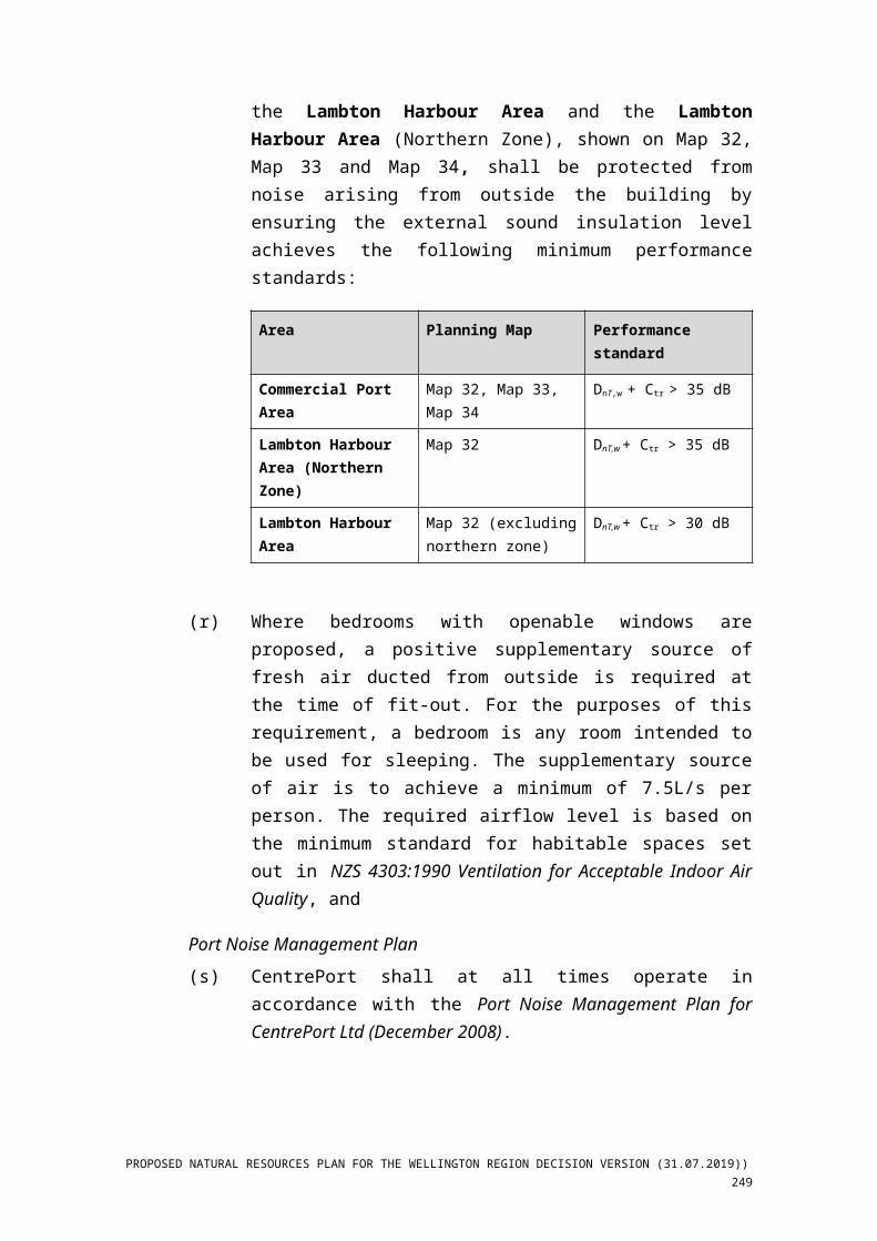
(s) Habitable rooms in buildings containing noise sensitive activities in a Commercial Port Area, the Lambton Harbour Area and the Lambton Harbour Area (Northern Zone), shown on Map 32, Map 33 and Map 34, shall be protected from noise arising from outside the building by ensuring the external sound insulation level achieves the following minimum performance standards:
Area Planning Map Performance standard
Commercial Port Area Map 32, Map 33, Map 34 DnT,w + Ctr > 35 dB
Lambton Harbour Area (Northern Zone)
Map 32 DnT,w + Ctr > 35 dB
Lambton Harbour Area Map 32 (excluding northern zone)
DnT,w + Ctr > 30 dB
PROPOSED NATURAL RESOURCES PLAN FOR THE WELLINGTON REGION DECISION VERSION (31.07.2019)) 243
(t) Where bedrooms with openable windows are proposed, a positive supplementary source of fresh air ducted from outside is required at the time of fit-out. For the purposes of this requirement, a bedroom is any room intended to be used for sleeping. The supplementary source of air is to achieve a minimum of 7.5L/s per person. The required airflow level is based on the minimum standard for habitable spaces set out in NZS 4303:1990 Ventilation for Acceptable Indoor Air Quality, and
Port Noise Management Plan(u) CentrePort shall at all times operate in accordance with the Port Noise
Management Plan for CentrePort Ltd (December 2008).
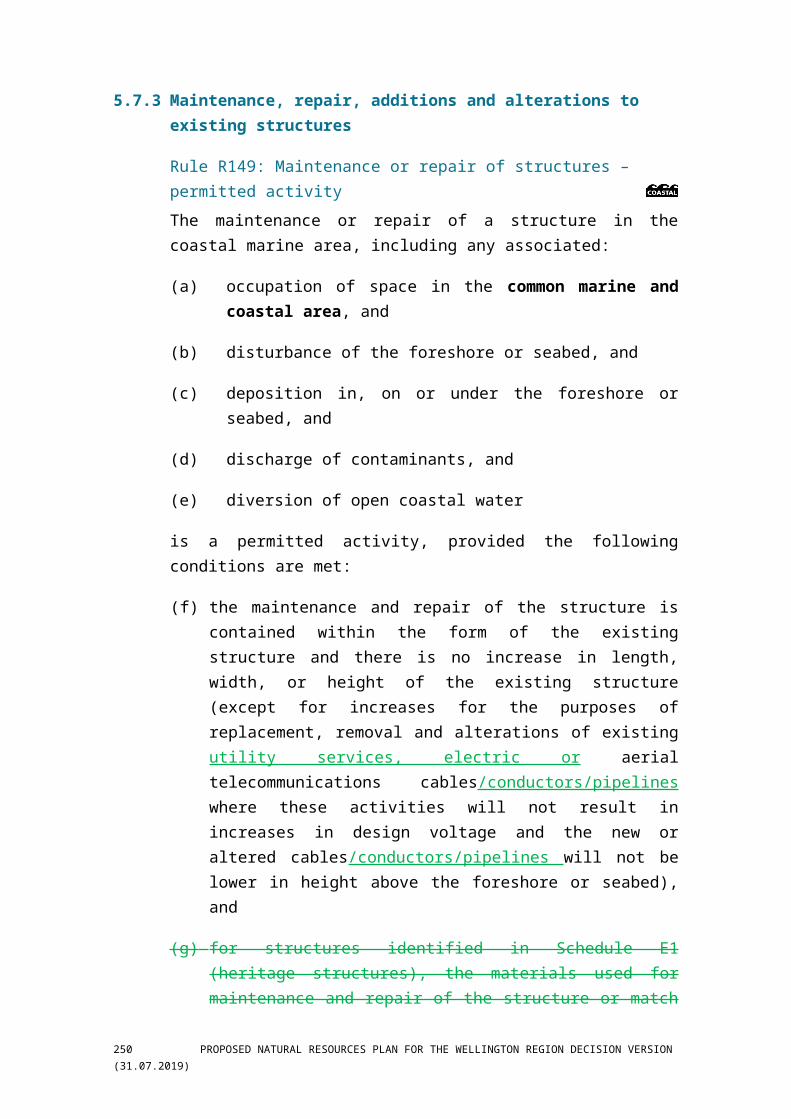
5.7.3 Maintenance, repair, additions and alterations to existing structures
Rule R149: Maintenance or repair of structures – permitted activity The maintenance or repair of a structure in the coastal marine area, including any associated:
(a) occupation of space in the common marine and coastal area, and
(b) disturbance of the foreshore or seabed, and
(c) deposition in, on or under the foreshore or seabed, and
(d) discharge of contaminants, and
(e) diversion of open coastal water
is a permitted activity, provided the following conditions are met:
(f) the maintenance and repair of the structure is contained within the form of the existing structure and there is no increase in length, width, or height of the existing structure (except for increases for the purposes of replacement, removal and alterations of existing utility services, electric or aerial telecommunications cables/conductors/pipelines where these activities will not result in increases in design voltage and the new or altered cables/conductors/pipelines will not be lower in height above the foreshore or seabed), and
(g) for structures identified in Schedule E1 (heritage structures), the materials used for maintenance and repair of the structure or match the existing structures in, form and appearance, and
244 PROPOSED NATURAL RESOURCES PLAN FOR THE WELLINGTON REGION DECISION VERSION (31.07.2019)
(h) the activity shall comply with the coastal management general conditions specified above in Section 5.7.2.
NoteRepainting is permitted by this rule and this rule applies to structures listed in Schedule E1 (heritage structures), Schedule E2 (wharves and boatsheds) and Schedule E3 (navigation aids) and structures in the Commercial Port Area.
This rule applies to all existing coastal marine area structures, including seawalls , navigation aids and port structures except those heritage structures identified in Schedules E1-E3 (in which case R168 applies)
Rule R150: Minor additions or alterations to structures – permitted activity The addition or alteration to a structure and the associated use of the addition in the coastal marine area, including any associated:
(a) occupation of space in the common marine and coastal area, and
(b) disturbance of the foreshore or seabed, and
(c) deposition in, on or under the foreshore or seabed, and
(d) discharge of contaminants, and
(e) diversion of open coastal water
is a permitted activity, provided the following conditions are met:
(f) the structure is not identified in Schedule E1 (heritage structures), Schedule E2 (wharves and boatsheds) or Schedule E3 (navigation aids), and
(g) there is no change in the use of the structure, and
(h) the structure is not a seawall, and
(i) the structure is not in the Commercial Port Area, and
(j) the minor addition or alteration shall add no more than 5m in horizontal projection and 1m in vertical projection to the structure as it existed on the date of 31 July 2015 public notification of the Proposed Natural Resources Plan (31.07.2015) in the coastal marine area, and
(k) when altering the depth or width of a stormwater pipe, any excavations do not excavate any deeper or wider that the original
PROPOSED NATURAL RESOURCES PLAN FOR THE WELLINGTON REGION DECISION VERSION (31.07.2019)) 245
grade or cross section of the stormwater pipe channel, unless the widening or deepening is for the purpose of constructing a sediment retention trap, and
(l) the activity shall comply with the coastal management general conditions specified above in Section 5.7.2.
Note Rule R173 and Rule R174 applies to additions and alterations in the Commercial Port Area.
Rule R151: Additions or alterations to structures – controlled
activity The addition or alteration to a structure and the associated use of the addition in the coastal marine area, including any associated:
(a) occupation of space in the common marine and coastal area, and
(b) disturbance of the foreshore or seabed, and
(c) deposition in, on or under the foreshore or seabed, and
(d) discharge of contaminants, and
(e) diversion of open coastal water
that are not permitted by Rule R149 or Rule R150, is a controlled activity, provided the following conditions are met:
(f) the structure is not identified in Schedule E1 (heritage structures), Schedule E2 (wharves and boatsheds) or Schedule E3 (navigation aids), and
(g) the structure is not located within a navigation protection area shown on Map 49, or in an airport height restriction area shown on Map 50 and 51, and
(h) there is no change in the use of the structure, and
(i) the structure is not a seawall, and
(j) the structure is not in the Commercial Port Area, and
(k) the addition shall add no more than 10m horizontal projection and 3m vertical projection to the structure as it existed on the date of 31 July
246 PROPOSED NATURAL RESOURCES PLAN FOR THE WELLINGTON REGION DECISION VERSION (31.07.2019)
2015 public notification of the Proposed Natural Resources Plan (31.07.2015), and
(l) the activity shall comply with the coastal management general conditions specified above in Section 5.7.2.
Matters of control1. The use of the structure
2. Effects on public access
3. Effects on public open space and visual amenity
4. Effects on coastal natural processes including effects on shoreline stability in the vicinity and adjacent areas
5. Effects on a site or habitat identified in Schedule C (mana whenua), Schedule F2c (birds-coastal), Schedule F4 (coastal sites), Schedule F5 (coastal habitats), or Schedule J (geological features) or Schedule K (surf breaks)
NotificationIn respect of Rule R151 applications are precluded from public notification (unless special circumstances exist).
NoteRule R173 and Rule R174 applies to additions and alterations in the Commercial Port Area.
Permission may be required from the relevant city or district council in respect of the Building Act 1991 or other legislation or bylaws.
5.7.4 Removal or demolition of structures
Rule R152: Removal or demolition of structures or part of a structure – permitted activity The removal or demolition of a structure or part of a structure in the coastal marine area, including any associated:
(a) disturbance of the foreshore or seabed, and
(b) deposition in, on or under the foreshore or seabed, and
(c) discharge of contaminants, and
(d) diversion of open coastal water
PROPOSED NATURAL RESOURCES PLAN FOR THE WELLINGTON REGION DECISION VERSION (31.07.2019)) 247
is a permitted activity, provided the following conditions are met:
(e) the structure is not identified in Schedule E1 (heritage structures), Schedule E2 (wharves and boatsheds) or Schedule E3 (navigation aids), and
(f) the structure is not inside a site or habitat identified in Schedule C (mana whenua), Schedule F4 (coastal sites) or Schedule F5 (coastal habitats), and
(g) the removal or demolition shall not disturb more than 10m3 of the foreshore or seabed, and
(h) the structure or part of the structure, is completely removed from the coastal marine area, except for structures within the Commercial Port Area, and
(i) no explosives shall be used in the removal or demolition, and
(j) written notice detailing the scale and location of the structure and the timing of construction and removal shall be given five working days before work commences to:
(i) the Wellington Regional Council Harbourmaster, and
(ii) Maritime New Zealand, and
(k) the activity shall comply with the coastal management general conditions specified above in Section 5.7.2.
Rule R153: Removal or demolition of a structure or part of a structure – restricted discretionary activity The removal or demolition of a structure or part of a structure in the coastal marine area, including any associated:
(a) disturbance of the foreshore or seabed, and
(b) deposition in, on or under the foreshore or seabed, and
(c) discharge of contaminants, and
(d) diversion of open coastal water
that is not permitted by Rule R152 and is not a discretionary activity under Rule R172 or Rule R166, or non-complying under Rule R162 is a restricted discretionary activity.
248 PROPOSED NATURAL RESOURCES PLAN FOR THE WELLINGTON REGION DECISION VERSION (31.07.2019)
Matters for discretion1. Effects on public access
2. Effects on public open space and visual amenity
3. Effects of disturbance, deposition, discharge and diversion associated with the removal
4. Effects on a site or habitat identified in Schedule C (mana whenua), Schedule F4 (coastal sites) or Schedule F5 (coastal habitats)
5. Lighting and noise
6. Navigational safety including the notification of the Wellington Regional Council Harbourmaster and Maritime New Zealand
5.7.5 New and replacement structures (including temporary structures)
Rule R154: New temporary structures outside sites of significance – permitted activity The placement of Aa new temporary structure and the associated use of the structure in the coastal marine area, including any associated:
(a) occupation of space in the common marine and coastal area, and
(b) disturbance of the foreshore or seabed, and
(c) deposition in, on or under the foreshore or seabed, and
(d) discharge of contaminants, and
(e) diversion of open coastal water
is a permitted activity, provided the following conditions are met:
(f) the structure is outside a site or habitat identified in Schedule C (mana whenua), Schedule F4 (coastal sites), Schedule F5 (coastal habitats) or Schedule J (geological features), and
(g) the structure is outside a navigation protection area shown on Map 49, or airport height restriction areas shown on Maps 50 and 51, and
(h) the structure shall be maintained in a safe condition at all times, and
(i) the entire structure shall be removed after use, and
PROPOSED NATURAL RESOURCES PLAN FOR THE WELLINGTON REGION DECISION VERSION (31.07.2019)) 249
(j) if the structure is on a wharf identified in Schedule E2 (wharves and boatsheds), the temporary structure shall not cause permanent physical damage to the wharf, and
(k) the structure shall not include advertising or marketing signage, and
(l) the structure shall not cause a hazard to navigation, and
(m) the structure shall not be in place for a period exceeding a total of 31 days or part days during a 12 month period, inclusive of the placement and removal, and
(n) the structure shall not prevent public access to and along the foreshore, and
(o) written notice detailing the scale and location of the structure and the timing of construction and removal shall be given five working days before work commences to:
(i) the Wellington Regional Council Harbourmaster, and
(ii) Maritime New Zealand,
(p) the activity shall comply with the coastal management general conditions specified above in Section 5.7.2.
Rule R155: New temporary structures – restricted discretionary
activity The placement of Aa new temporary structure and the associated use of the structure in the coastal marine area, including any associated:
(a) occupation of space in the common marine and coastal area, and
(b) disturbance of the foreshore or seabed, and
(c) deposition in, on or under the foreshore or seabed, and
(d) discharge of contaminants, and
(e) diversion of open coastal water
that is not permitted by Rule R154 is a restricted discretionary activity.
Matters for discretion1. Use of the structure
2. Effects on public access
250 PROPOSED NATURAL RESOURCES PLAN FOR THE WELLINGTON REGION DECISION VERSION (31.07.2019)
3. Effects on public open space and visual amenity
4. Effects of disturbance, deposition, discharge and diversion associated with the activity
5. Effects on coastal natural processes including effects on shoreline stability in the vicinity and adjacent areas
6. Effects on a site or habitat identified in Schedule C (mana whenua), Schedule F4 (coastal sites), Schedule F5 (coastal habitats) or Schedule J (geological features)
7. Effects on the heritage values of structures identified in Schedule E1 (heritage structures) or Schedule E2 (wharves and boatsheds)
8. Lighting and noise
9. The structural integrity and condition of the structure
10. Navigational safety including the notification of the Wellington Regional Council Harbourmaster and Maritime New Zealand
Rule R156: New or replacement navigation aids – permitted
activity The placement of Aa new or replacement navigational aid and the associated use of the structure in the coastal marine area, including any associated:
(a) occupation of space in the common marine and coastal area, and
(b) disturbance of the foreshore or seabed, and
(c) deposition in, on or under the foreshore or seabed, and
(d) discharge of contaminants, and
(e) diversion of open coastal water
is a permitted activity, provided the following conditions are met:
(f) the navigation aid is not listed in Schedule E3 (navigation aids), and
(g) written notice detailing the scale and location of the structure and the timing of construction and removal shall be given five working days before work commences to:
(i) the Wellington Regional Council Harbourmaster, and
PROPOSED NATURAL RESOURCES PLAN FOR THE WELLINGTON REGION DECISION VERSION (31.07.2019)) 251
(ii) Maritime New Zealand, and
(iii) Land Information New Zealand, and
(h) the navigational aid shall be maintained in a structurally safe condition at all times, and
(i) the activity shall comply with the coastal management general conditions specified above in Section 5.7.2.
Rule R157: New or replacement structures for special purposes – controlled activity The placement of Aa new structure or the replacement of a structure for scientific, research, monitoring and education purposes and the associated use of the structure in the coastal marine area, including any associated:
(a) occupation of space in the common marine and coastal area, and
(b) disturbance of the foreshore or seabed, and
(c) deposition in, on or under the foreshore or seabed, and
(d) discharge of contaminants, and
(e) diversion of open coastal water
is a controlled activity, provided the following conditions are met:
(f) the structure in not identified in Schedule E1 (heritage structures), Schedule E2 (wharves and boatsheds) or Schedule E3 (navigation aids), and
(g) the activity is not inside a site identified in Schedule E4 (archaeological sites) or Schedule J (geological features), and
(h) the structure is outside a navigation protection area identified on Map 49, and
(i) there is no change in use of the structure, and
(j) the structure does not exceed an area of 2m2 or a vertical projection of 2m, and
(k) the activity shall comply with the coastal management general conditions specified above in Section 5.7.2.
Matters of control1. Use of the structure
252 PROPOSED NATURAL RESOURCES PLAN FOR THE WELLINGTON REGION DECISION VERSION (31.07.2019)

2. Effects on public access
3. Effects of disturbance, deposition, discharge and diversion associated with construction
4. Effects on coastal natural processes including effects on shoreline stability in the vicinity and adjacent areas
5. Effects on a site or habitat identified in Schedule C (mana whenua), Schedule F2c (birds-coastal), Schedule F4 (coastal sites), Schedule F5 (coastal habitats) or Schedule K (surf breaks).
6. Lighting and noise mitigation methods
NotificationIn respect of Rule R157, applications are precluded from public notification (unless special circumstances exist).
Rule R158: Structures in airport height restriction areas or navigation protection areas for airport/navigation purposes – discretionary
activity The placement of Aa new structure including a temporary structure or addition or alteration to a structure and the associated use of the structure:
(a) in a navigation protection area shown on Map 49, or
(b) within an airport height restriction area shown on Map 50 or Map 51,
including any associated:
(c) occupation of space in the common marine and coastal area, and
(d) disturbance of the foreshore or seabed, and
(e) deposition in, on or under the foreshore or seabed, and
(f) discharge of contaminants, and
(g) diversion of open coastal water
is a discretionary activity, provided the following conditions are met:
(h) in respect of condition (a), written approval is given by the relevant airport authority, and
(i) in respect of condition (b), written approval is given by the Wellington Regional Council Harbourmaster.
PROPOSED NATURAL RESOURCES PLAN FOR THE WELLINGTON REGION DECISION VERSION (31.07.2019)) 253
Rule R159: Structures in airport height restriction areas or navigation protection areas – prohibited activity The placement of Aa new structure including a temporary structure or addition or alteration to a structure (excluding navigation aids, cables and pipelines fixed to the seabed) and the associated use of the structure in a navigation protection area shown on Map 49 or within an airport height restriction area shown on Map 50 or Map 51, including any associated:
(a) occupation of space in the common marine and coastal area, and
(b) disturbance of the foreshore or seabed, and
(c) deposition in, on or under the foreshore or seabed, and
(d) discharge of contaminants, and
(e) diversion of open coastal water
that is not a discretionary activity under Rule R158, is a prohibited activity.
Rule R160: New structures and disturbance associated with motor vehicles inside the Cook Strait Cable Protection Zone and adjacent foreshore, and inside a mana whenua sites of significance – discretionary activity The placement of Aa new structure and the associated use of the structure and disturbance associated with motor vehicles in the coastal marine area:
(a) specific to the National grid, and
(b) related to the Cook Strait Cable within inside the Cook Strait Cable Protection Zone shown on Map 52, and adjacent foreshore, and
(c) inside a site of significance identified in Schedule C (mana whenua),
including any associated:
(a)(d) occupation of the common marine and coastal area, and
(b)(e) disturbance of the foreshore or seabed, and
(c)(f) deposition in, on or under the foreshore or seabed, and
(d)(g) discharge of contaminants, and
(e)(h) diversion of open coastal water
that is not permitted controlled by Rule R157 is a discretionary activity.
254 PROPOSED NATURAL RESOURCES PLAN FOR THE WELLINGTON REGION DECISION VERSION (31.07.2019)
Rule R161: New structures, additions or alterations to structures outside sites of significance – discretionary activity The placement of Aa new structure, addition or alteration to a structure and the associated use of the structure outside a site or habitat identified in Schedule C (mana whenua), Schedule F4 (coastal sites), Schedule F5 (coastal habitats) or Schedule J (geological features) in the coastal marine area, including any associated:
(a) occupation of space in the common marine and coastal area, and
(b) disturbance of the foreshore or seabed, and
(c) deposition in, on or under the foreshore or seabed, and
(d) discharge of contaminants, and
(e) diversion of open coastal water
that is not permitted by Rule R156, Rule R175, Rule R176, or controlled by Rule R151 or Rule R157 or Rule R174 or restricted discretionary under Rule R155 or prohibited under Rule R159 is a discretionary activity.
Rule R162: New structures, additions or alterations to structures inside sites of significance – non-complying activity The placement of Aa new structure, addition or alteration to a structure and the associated use of the structure inside a site or habitat identified in Schedule C (mana whenua), Schedule F4 (coastal sites), Schedule F5 (coastal habitats) or Schedule J (geological features) in the coastal marine area, including any associated:
(a) occupation of space in the common marine and coastal area, and
(b) disturbance of the foreshore or seabed, and
(c) deposition in, on or under the foreshore or seabed, and
(d) discharge of contaminants, and
(e) diversion of open coastal water
that is not permitted by Rule R156, Rule R175, Rule R176 or a controlled activity under Rule R151, Rule R157 and Rule R174, or a restricted discretionary activity under Rule R155 or a discretionary activity under Rule R160, or prohibited under Rule R159 is a non-complying activity.
PROPOSED NATURAL RESOURCES PLAN FOR THE WELLINGTON REGION DECISION VERSION (31.07.2019)) 255
Rule R163: Replacement of structures or parts of structures – permitted activity The replacement of a structure or part of a structure and the associated use of the structure in the coastal marine area, including any associated:
(a) occupation of space in the common marine and coastal area, and
(b) disturbance of the foreshore or seabed, and
(c) deposition in, on or under the foreshore or seabed, and
(d) discharge of contaminants, and
(e) diversion of open coastal water
is a permitted activity, provided the following conditions are met:
(f) the replacement structure has a functional need or operational requirement to be located in the coastal marine area, and
(g) the structure is not a seawall (excluding revetments or those seawalls protecting wharves within a Commercial Port Area), and
(h) there is no change in the use of the structure, and
(i) the replacement structure is built in the same or similar location as the original structure, and
(j) the replacement structure has the same or lesser footprint as the original structure, and
(k) the replacement structure maintains the form of the original structure and there is no increase in the length, width or height, and
(l) the replacement structure is not inside a site or habitat identified in Schedule C (mana whenua), Schedule E1 (heritage structures), Schedule E2 (wharves and boatsheds), Schedule E3 (navigation aids), Schedule F4 (coastal sites), Schedule F5 (coastal habitats) or Schedule J (geological features) excluding those structures for scientific, research or education purposes that will enhance the understanding and long term protection of the coastal marine area, and
(m) the activity shall comply with the coastal management general conditions specified above in Section 5.7.2.
256 PROPOSED NATURAL RESOURCES PLAN FOR THE WELLINGTON REGION DECISION VERSION (31.07.2019)

Rule R164: Replacement of structures or parts of structures – restricted discretionary
activity The replacement of a structure or part of a structure and the associated use of the structure in the coastal marine area, including any associated:
(a) occupation of space in the common marine and coastal area, and
(b) disturbance of the foreshore or seabed, and
(c) deposition in, on or under the foreshore or seabed, and
(d) discharge of contaminants, and
(e) diversion of open coastal water
that is not permitted by Rule R149, Rule R152, Rule R156 or Rule R163 or a controlled activity by Rule R157, is a restricted discretionary activity. provided the following conditions are met:
(f) the structure is not identified in Schedule E1 (heritage structures), Schedule E2 (wharves and boatsheds) or Schedule E3 (navigation aids).
Matters for discretion1. The use of the structure
2. Effects on public access
3. Effects on public open space and visual amenity
4. Effects of disturbance, deposition, discharge and diversion associated with the activity
5. Effects on a site or habitat identified in Schedule C (mana whenua), Schedule F4 (coastal sites), Schedule F5 (coastal habitats) or Schedule J (geological features)
6. Light and noise
7. Effects on shoreline stability in the vicinity and nearby areas
PROPOSED NATURAL RESOURCES PLAN FOR THE WELLINGTON REGION DECISION VERSION (31.07.2019)) 257

5.7.6 Seawalls
Rule R165: Additions or alterations to, or replacements of, existing seawalls – controlled activity The addition or alteration to, or replacements of, an existing seawall and the associated use of the addition in the coastal marine area, including any associated:
(a) occupation of space in the common marine and coastal area, and
(b) disturbance of the foreshore or seabed, and
(c) deposition in, on or under the foreshore or seabed, and
(d) discharge of contaminants, and
(e) diversion of open coastal water
is a controlled activity, provided the following conditions are met:
(f) any addition shall add no more than 5m in horizontal projection and 1m in vertical projection to the structure as it existed on the date of 31 July 2015 public notification of the Proposed Natural Resources Plan (31.07.2015),
(g) the addition shall not extend any further seaward than the existing seawall, and
(h) the activity shall comply with the coastal management general conditions specified above in Section 5.7.2.
Matters of control1. Effects on public access
2. Design and construction
3. Effects on coastal natural processes including effects on shoreline stability in the vicinity and adjacent areas
4. Effects on a site or habitat identified in Schedule C (mana whenua), Schedule F4 (coastal sites), Schedule F5 (coastal habitats), Schedule J (geological features) or Schedule K (surf breaks)
5. Effects on the heritage values of structures identified in Schedule E1 (heritage structures), Schedule E2 (wharves and boatsheds) or Schedule E3 (navigational aids)
258 PROPOSED NATURAL RESOURCES PLAN FOR THE WELLINGTON REGION DECISION VERSION (31.07.2019)
Rule R166: Seawalls outside sites of significance – discretionary
activity The placement of Aa new seawall, or the addition to or alteration or replacement of an existing seawall, and the associated use of the structure outside a site or habitat identified in Schedule C (mana whenua), Schedule F4 (coastal sites), Schedule F5 (coastal habitats) or Schedule J (geological features) in the coastal marine area including any associated:
(a) occupation of space in the common marine and coastal area, and
(b) disturbance of the foreshore or seabed, and
(c) deposition in, on or under the foreshore or seabed, and
(d) discharge of contaminants, and
(e) diversion of open coastal water
that is not a controlled activity under Rule R165 is a discretionary activity.
Rule R167: Seawalls inside sites of significance – non-complying activity The placement of Aa new seawall, or the addition to or alteration or replacement of an existing seawall, and the associated use of the structure inside a site or habitat identified in Schedule C (mana whenua), Schedule F4 (coastal sites), Schedule F5 (coastal habitats) or Schedule J (geological features) in the coastal marine area including any associated:
(a) occupation of space in the common marine and coastal area, and
(b) disturbance of the foreshore or seabed, and
(c) deposition in, on or under the foreshore or seabed, and
(d) discharge of contaminants, and
(e) diversion of open coastal water
that is not a controlled activity under Rule R165 or a discretionary activity under Rule R166, is a non-complying activity.
PROPOSED NATURAL RESOURCES PLAN FOR THE WELLINGTON REGION DECISION VERSION (31.07.2019)) 259
5.7.7 Heritage structures
Rule R168: Maintenance or repair or A a lteration of structures in
Schedule E1, E2, and E3 – permitted activityThe maintenance or repair or alteration of a structure identified in Schedule E1 (heritage structures), E2 (wharves and boatsheds) or E3 (navigation aids) in the coastal marine area, including any associated:
(a) occupation of space in the common marine and coastal area, and
(b) disturbance of the foreshore or seabed, and
(c) deposition in, on or under the foreshore or seabed, and
(d) discharge of contaminants
is a permitted activity, provided the following conditions are met:
(e) the alteration is contained within the form of the existing structure and there is no increase in the length, width, or height of the existing structure, and
(f) (e) for structures identified in Schedule E1 (heritage structures), Schedule E2 (wharves and boatsheds) and Schedule E3 (navigation aids), the materials used for maintenance or repair or alteration of the structure shall use the same materials, or the altered components should be of similar materials as the original it replaces in texture, form profile, design and appearance, and
(f) any alteration is contained within the form of the existing structure and there is no increase in length, width, height of the existing structure, and
(g) the number of components altered should be substantially less than existing number of components, and
(h) the alteration does not include the removal, relocation, partial or total demolition of any structure, and
(i) the activity shall comply with the coastal management general conditions specified above in Section 5.7.2.
NoteRepainting is permitted by this rule.
260 PROPOSED NATURAL RESOURCES PLAN FOR THE WELLINGTON REGION DECISION VERSION (31.07.2019)
Rule R169: Additions or alterations to structures identified in Schedule E1 or Schedule E2– restricted discretionary activity The addition or alteration to a structure identified in Schedule E1 (heritage structures), or Schedule E2 (wharves and boatsheds), and the associated use of the addition in the coastal marine area, including any associated:
(a) occupation of space in the common marine and coastal area, and
(b) disturbance of the foreshore or seabed, and
(c) deposition in, on or under the foreshore or seabed, and
(d) discharge of contaminants
that is not permitted by Rule R168, is a restricted discretionary activity, provided the following conditions are met:
(e) the structure is not a seawall, and
(f) the activity shall comply with the coastal management general conditions specified above in Section 5.7.2.
Matters for discretion1. Use of the structure
2. Effects on public access
3. Effects on public open space and visual amenity
4. Effects of disturbance, deposition and discharge associated with construction
5. Effects on the historic heritage values of structures identified in Schedule E1 (heritage structures) or Schedule E2 (wharves and boatsheds)
6. Lighting and noise
7. Effects on coastal natural processes including effects on shoreline stability in the vicinity and adjacent areas
NoteAdditions or alterations to seawalls are either a controlled activity under Rule R165, a discretionary activity under Rule R166 or a non-complying activity under Rule R167.
PROPOSED NATURAL RESOURCES PLAN FOR THE WELLINGTON REGION DECISION VERSION (31.07.2019)) 261
Rule R170: Additions to structures identified in Schedule E3 – permitted activity The addition to a structure identified in Schedule E3 (navigation aids), and the associated use of the addition in the coastal marine area, including any associated:
(a) occupation of space in the common marine and coastal area, and
(b) disturbance of the foreshore or seabed, and
(c) deposition in, on or under the foreshore or seabed, and
(d) discharge of contaminants
is a permitted activity, provided the following conditions are met:
(e) the addition is for navigation safety or the efficiency of its operation, and
(f) the addition shall add no more than 3m in horizontal projection and 2m in vertical projection to the structure as it existed on 31 July 2015 the date of public notification of the Proposed Natural Resources Plan (31.07.2015), and
(g) the activity shall comply with the coastal management general conditions specified above in Section 5.7.2.
Rule R171: Additions or alterations to structures identified in Schedule E1, Schedule E2 or Schedule E3– discretionary activity The addition or alteration to a structure identified in Schedule E1 (heritage structures), Schedule E2 (wharves and boatsheds), or Schedule E3 (navigation aids) and the associated use of the addition in the coastal marine area, including any associated:
(a) occupation of space in the common marine and coastal area, and
(b) disturbance of the foreshore or seabed, and
(c) deposition in, on or under the foreshore or seabed, and
(d) discharge of contaminants
that is not permitted by Rule R168 or Rule R170 discretionary activity under Rule R169 is a discretionary activity.
262 PROPOSED NATURAL RESOURCES PLAN FOR THE WELLINGTON REGION DECISION VERSION (31.07.2019)
Rule R172: Removal, demolition or replacement of structures or parts of structures identified in Schedule E1, Schedule E2 or Schedule E3 – discretionary activity The removal, demolition or replacement of a structure or part of a structure identified in Schedule E1 (heritage structures), Schedule E2 (wharves and boatsheds) or Schedule E3 (navigation aids) or Schedule E6 (Lambton Harbour Heritage Area) and the associated use of a structure in the coastal marine area, including any associated:
(a) occupation of space in the common marine and coastal area, and
(b) disturbance of the foreshore or seabed, and
(c) deposition in, on or under the foreshore or seabed, and
(d) discharge of contaminants
that is not permitted by Rule R152, Rule R165, Rule R168, Rule R149, or Rule R170 or R173, or controlled under Rule R157 or Rule R165, or discretionary restricted restricted discretionary under Rule R153, R169, or R173 is a discretionary activity
5.7.8 Structures in the Commercial Port Area
Rule R173: Maintenance or repair or Aadditions or alterations to structures inside a Commercial Port Area – permitted activity The maintenance or repair or addition or alteration to a structure inside a Commercial Port Area shown on Map 32, Map 33 and Map 34 and the associated use of the addition in the coastal marine area, including any associated:
(a) occupation of space in the common marine and coastal area, and
(b) disturbance of the foreshore or seabed, and
(c) deposition in, on or under the foreshore or seabed, and
(d) discharge of contaminants, and
(e) diversion of open coastal water
is a permitted activity, provided the following conditions are met:
(f) the structure is not inside a site or habitat identified in Schedule C (mana whenua), Schedule F4 (coastal sites) or Schedule F5 (coastal habitats), and
PROPOSED NATURAL RESOURCES PLAN FOR THE WELLINGTON REGION DECISION VERSION (31.07.2019)) 263

(g) the maintenance or repair or addition and alteration shall add no more than 30m horizontal projection and 10m vertical projection to the structure, as it existed on the date of 31 July 2015 public notification of the Proposed Natural Resources Plan (31.07.2015), and
(h) the activity shall comply with the coastal management general conditions specified above in Section 5.7.2.
Rule R174: Maintenance or repair or Aadditions or alterations to structures inside a Commercial Port Area – controlled activity The maintenance or repair or addition or alteration to a structure inside a Commercial Port Area shown on Map 32, Map 33 and Map 34 and the associated use of the addition in the coastal marine area, including any associated:
(a) occupation of space in the common marine and coastal area, and
(b) disturbance of the foreshore or seabed, and
(c) deposition in, on or under the foreshore or seabed, and
(d) discharge of contaminants, and
(e) diversion of open coastal water
that is not permitted by Rule R149 or Rule R173 is a controlled activity, provided the following conditions are met:
(f) the structure is not identified in Schedule E2 (wharves and boatsheds), and
(g)(f) the addition and alteration shall add no more than 50m horizontal projection and 20m vertical projection to the structure as it existed on the date of 31 July 2015 public notification of the Proposed Natural Resources Plan (31.07.2015), and
(h)(g) the activity shall comply with the coastal management general conditions specified above in Section 5.7.2.
Matters of control1. Use of the structure
2. Lighting and noise mitigation methods
3. Effects on coastal natural processes including effects on shoreline stability in the vicinity and adjacent areas
264 PROPOSED NATURAL RESOURCES PLAN FOR THE WELLINGTON REGION DECISION VERSION (31.07.2019)
4. Effects of disturbance, deposition, discharge and diversion associated with the activity
NotificationIn respect of Rule R174, applications are precluded from public notification (unless special circumstances exist).
Rule R175: New structures associated with passenger and cargo handling inside the Commercial Port Area – permitted activity The placement of Aa new structure associated with passenger handling (for the transfer of passengers, crews and other persons) or cargo handling and the associated use of the structure inside a Commercial Port Area shown on Map 32, Map 33 and Map 34 in the coastal marine area, including any associated:
(a) occupation of space in the common marine and coastal area, and
(b) disturbance of the foreshore or seabed, and
(c) deposition in, on or under the foreshore or seabed, and
(d) discharge of contaminants, and
(e) diversion of open coastal water
is a permitted activity, provided the following conditions are met:
(f) the structure shall not exceed a height of 27m, and
(g) the activity shall comply with the coastal management general conditions specified above in Section 5.7.2.
5.7.9 Boatsheds and swing moorings
Rule R176: Use of boatsheds – permitted activity The use of a boatshed in the coastal marine area, for water based activities that require a coastal location, is a permitted activity, provided the following condition is met:
(a) the activity shall comply with the coastal management general conditions specified above in Section 5.7.2.
Rule R177: Change of use of boatsheds – non-complying activity The change in use of a boatshed in the coastal marine area to an activity that does not have a functional need to be in the coastal marine area, after the date of 31 July 2015 public notification of the Proposed Natural Resources Plan (31.07.2015), including any associated:
PROPOSED NATURAL RESOURCES PLAN FOR THE WELLINGTON REGION DECISION VERSION (31.07.2019)) 265
(a) occupation of space in the common marine and coastal area, and
(b) disturbance of the foreshore or seabed, and
(c) deposition in, on or under the foreshore or seabed, and
(d) discharge of contaminants
is a non-complying activity.
NotificationIn respect of Rule R177, applications must be publicly notified.
Rule R178: New boatsheds inside Boatshed Management Areas – discretionary activity The placement of Aa new boatshed inside a Boatshed Management Area shown on Map 31 and the associated use of the boatshed in the coastal marine area, including any associated:
(a) occupation of space in the common marine and coastal area, and
(b) disturbance of the foreshore or seabed, and
(c) deposition in, on or under the foreshore or seabed, and
(d) discharge of contaminants
is a discretionary activity.
Rule R179: New boatsheds outside Boatshed Management Areas – non-complying activity The placement of Aa new boatshed outside a Boatshed Management Area shown on Map 31 and the associated use of the boatshed in the coastal marine area that is not a discretionary activity under Rule R178, is a non-complying activity.
Rule R180: New sSwing moorings inside Mooring Areas – permitted activity The placement of Aa new swing mooring inside a Mooring Area shown on Map 36, Map 37, Map 38, Map 39, Map 40 or Map 41 and the associated use of the swing mooring in the coastal marine area, including any associated:
(a) occupation of space in the common marine and coastal area, and
(b) disturbance of the foreshore or seabed, and
(c) deposition in, on or under the foreshore or seabed, and
266 PROPOSED NATURAL RESOURCES PLAN FOR THE WELLINGTON REGION DECISION VERSION (31.07.2019)
(d) discharge of contaminants
is a permitted activity, provided the following conditions are met:
(e) the mooring area has available mooring space, and
(f) a mooring licence has been obtained from the Wellington Regional Council Harbourmaster, or a resource consent is held, and
(g) the activity shall comply with the coastal management general conditions specified above in Section 5.7.2.
Rule R181: New swing moorings outside Mooring Areas – non-complying activity The placement of Aa new swing mooring outside a Mooring Area shown on Map 36, Map 37, Map 38, Map 39, Map 40 and Map 41 and the associated use of the swing mooring in the coastal marine area, including any associated:
(a) occupation of space in the common marine and coastal area, and
(b) disturbance of the foreshore or seabed, and
(c) deposition in, on or under the foreshore or seabed, and
(d) discharge of contaminants
is a non-complying activity.
NotificationIn respect of Rule R181, applications must be publicly notified are precluded from public notification (unless special circumstances exist).
5.7.10 Occupation
Rule R182: Occupation of space by regionally significant infrastructure or a structure owned by a network utility operator – permitted activity The occupation of space in the common marine and coastal area by a structure existing before the date of 31 July 2015 public notification of the Proposed Natural Resources Plan (31.07.2015) which is regionally significant infrastructure or owned by a network utility operator is a permitted activity.
Rule R183: Renewal of existing resource consents for occupation of space by structures – controlled activity The first renewal of an existing resource consent for the occupation of space by a structure in the common marine and coastal area, after the date of 31
PROPOSED NATURAL RESOURCES PLAN FOR THE WELLINGTON REGION DECISION VERSION (31.07.2019)) 267
July 2015 public notification of the Proposed Natural Resources Plan (31.07.2015)is a controlled activity.
Matters of control1. Effects on public access
2. Effects on public open space and visual amenity
NotificationIn respect of Rule R183, applications are precluded from public notification (unless special circumstances exist).
Rule R184: Occupation of space – discretionary activity The occupation of space in the common marine and coastal area that is not permitted, controlled, restricted discretionary, non-complying or prohibited is a discretionary activity.
5.7.11 Surface water and foreshore activities
Rule R185: General surface water and foreshore activities – permitted activity General surface water and foreshore activities and the associated use in the coastal marine area, including any associated:
(a) occupation of space in the common marine and coastal area, and
(b) disturbance of the foreshore or seabed, and
(c) deposition in, on or under the foreshore or seabed, and
(d) discharge of contaminants
is a permitted activity, provided the following conditions are met:
(e) the activity is not inside the Lambton Harbour Area (including Northern Zone) shown on Map 32, and
(f) if the activity includes occupation of space in the common marine and coastal area that excludes public access or navigation of ships:
(i) the area of occupation shall be less than 1ha, and
(ii) the activity shall comply with the Wellington Regional Council Navigation and Safety Bylaws Wellington Region 2009, and
268 PROPOSED NATURAL RESOURCES PLAN FOR THE WELLINGTON REGION DECISION VERSION (31.07.2019)
(iii) the occupation shall not affect the operational requirement of emergency services including the coastguard, police and surf lifesaving, and
(iv) written notice shall be given five working days before work commences to:
a. the Wellington Regional Council Harbourmaster, and
b. Maritime New Zealand, and
c. the relevant territorial authority, and
(v) the duration of the activity in a 12 month period must not exceed:
a. for temporary military training activities, 30 days, and
b. for all other activities, seven days, and
(g) if the activity will exclude public access or navigation of ships in the common marine and coastal area for more than 24 hours:
(i) the public shall be notified of the proposed activity and associated restrictions on use of the area, including via a public notice in local newspapers, at least 14 working days prior to the commencement of the activity, and
(ii) signs shall be placed at the location of the activity notifying the public of the event with dates, times, the activity proposed, any restrictions imposed on the use of the area and contact information of the organiser at least seven working days prior to the occupation commencing, and
(h) the activity shall comply with the coastal management general conditions specified above in Section 5.7.2.
NotePermission may be required from the relevant city or district council.
Any activities which disturb the foreshore or seabed within the Cook Strait Cable Protection Zone (shown in Map 52), including anchoring and fishing, has the potential to damage the Cook Strait Cables, and is required to comply with the Submarine Cables and Pipeline Protection Order 2009.
PROPOSED NATURAL RESOURCES PLAN FOR THE WELLINGTON REGION DECISION VERSION (31.07.2019)) 269

Rule R186: General surface water and foreshore activities – restricted discretionary General surface water and foreshore activities and the associated use in the coastal marine area, including any associated:
(a) occupation of space in the common marine and coastal area, and
(b) disturbance of the foreshore or seabed, and
(c) deposition in, on or under the foreshore or seabed, and
(d) discharge of contaminants
that is not permitted by Rule R185 is a restricted discretionary activity, provided the following conditions are met:
(e) the activity shall comply with the coastal management general conditions specified above in Section 5.7.2.
Matters for discretion1. Effects on public access
2. Effects on public open space and visual amenity
3. Use of the structure
4. Extent and exclusivity of the occupation of the common marine and coastal area
5. Navigation safety
6. Lighting and noise
7. Effects on a site or habitat identified in or using Schedule C (mana whenua), Schedule F4 (coastal sites), Schedule F5 (coastal habitats), Schedule J (geological features) or Schedule K (surf breaks)
8. Effects on the heritage values of structures identified in Schedule E1 (heritage structures), Schedule E2 (wharves and boatsheds) or Schedule E3 (navigational aids)
Rule R187: General surface water and foreshore activities – discretionary activity General surface water and foreshore activities in and the associated use of the coastal marine area, including any associated:
(a) occupation of space in the common marine and coastal area, and
270 PROPOSED NATURAL RESOURCES PLAN FOR THE WELLINGTON REGION DECISION VERSION (31.07.2019)
(b) disturbance of the foreshore or seabed, and
(c) deposition in, on or under the foreshore or seabed, and
(d) discharge of contaminants
not permitted by Rule R185 or restricted discretionary under Rule R186 is a discretionary activity.
5.7.12 General disturbance activities
Rule R188: Minor disturbances – permitted activity The disturbance of the foreshore or seabed including any removal of sand, shingle, shell or other natural material in the coastal marine area, including any associated:
(a) occupation of space in the common marine and coastal area, and
(b) deposition in, on or under the foreshore or seabed, and
(c) discharge of contaminants
is a permitted activity, provided the following conditions are met:
(d) the activity shall not be inside a site or habitat identified in or using Schedule C (mana whenua), Schedule E4 (archaeological sites), Schedule F2c (birds-coastal) or Schedule J (geological features), and
(e) no more than 0.1m3 of sand, shingle, shell or other natural material shall be taken by a person in a 12 month period, and
(f) the removed natural material shall not be used for commercial gain, and
(g) the area of excavation shall be smoothed over after the completion of the activity (e.g. no holes left on the foreshore), and
(h) the extent of the foreshore or seabed disturbance is limited to that required to undertake the activity, and
(i) no motorised excavation machinery shall be used to disturb or remove sand, shingle, shell or other natural material.
NoteWhile the removal of natural materials from a marine reserve (unless authorised for research purposes) is prohibited under the Marine Reserves Act 1971, a memorandum of understanding between the Department of
PROPOSED NATURAL RESOURCES PLAN FOR THE WELLINGTON REGION DECISION VERSION (31.07.2019)) 271
Conservation and the Wellington City Council enables the removal of natural material (beach grooming) within Taputeranga Marine Reserve with particular conditions.
Rule R189: Clearance of stormwater pipes – permitted activity The disturbance of the foreshore or seabed from the clearance of a stormwater pipe in the coastal marine area, including any associated:
(a) occupation of space in the common marine and coastal area, and
(b) deposition in, on or under the foreshore or seabed, and
(c) discharge of contaminants
is a permitted activity, provided the following conditions are met:
(d) the disturbance is undertaken by or for a local authority or a road controlling authority or is required for port maintenance, and
(e) the extent of the foreshore or seabed disturbance is limited to that required to create a free-draining path from the stormwater outlet to the sea, and
(f) the disturbance shall not prevent public access to or along the foreshore, and
(g) all material excavated is retained within the active beach system except for visibly contaminated material. Any visibly contaminated material shall be removed from the beach system and disposed of appropriately, and
(h) excavated material is not mounded, bunded and/or deposited in a manner that creates ponding or the diversion of water on the foreshore or seabed, and
(i) the activity shall comply with the coastal management general conditions specified above in Section 5.7.2.
Rule R191: Disturbance associated with beach grooming – permitted activity The disturbance of the foreshore or seabed for beach grooming including any removal of sand, shingle, shell or other natural material in the coastal marine area, including any associated:
(a) deposition in, on or under the foreshore or seabed, and
(b) discharge of contaminants
272 PROPOSED NATURAL RESOURCES PLAN FOR THE WELLINGTON REGION DECISION VERSION (31.07.2019)
on the following beaches:
Ōtaki, Te Horo, Peka Peka, Waikanae, Paraparaumu, Raumati, Paekakariki, Tītahi Bay (excluding the area of fossil forest shown on Map 35), Karehana Bay, Plimmerton, Browns Bay, Bradley Point, Motukaraka Point, Mana Foreshore, Onehunga Bay, Dolly Varden Beach, Pukerua Bay, Lyall Bay, Island Bay, Princess Bay, Worser Bay, Scorching Bay, Oriental Bay, Freyberg, Petone, Point Howard, Sorrento Bay, Days Bay, Rona Bay, Castlepoint, Riversdale
is a permitted activity, provided the following conditions are met:
(c) the beach grooming shall be carried out for the purpose of grooming and the removal of marine debris and litter, and
(d) the activity shall be undertaken by or for a local authority, and
(e) the activity shall not occur when shellfish beds are exposed, and
(f) the activity shall not be within a site identified in Schedule C (mana whenua) or Schedule E4 (archaeological sites) or Schedule F4 (significant indigenous biodiversity values in the coastal marine area), except on Island Bay beach, and
(g) the activity shall not be within the Tītahi Bay fossil forest shown on Map 35., and
(h) the activity shall comply with the coastal management general conditions specified above in section 5.7.2.
NoteWhile the removal of natural materials from a marine reserve (unless authorised for research purposes) is prohibited under the Marine Reserves Act 1971, regulation 7 of the Marine Reserves (Taputeranga) Order 2008 a memorandum of understanding between the Department of Conservation and Wellington City Council enables a local authority to remove beach cast seaweed and debris after a storm beach grooming within Taputeranga Marine Reserve with particular conditions.
Rule R192: Beach recontouring for coastal restoration purposes – controlled activity The disturbance of the foreshore or seabed for beach recontouring in the coastal marine area, including any associated:
(a) deposition in, on or under the foreshore or seabed, and
PROPOSED NATURAL RESOURCES PLAN FOR THE WELLINGTON REGION DECISION VERSION (31.07.2019)) 273
(b) discharge of contaminants
is a controlled activity, provided the following conditions are met:
(c) the activity forms part of a coastal restoration plan, and
(d) the activity shall comply with the coastal management general conditions specified above in Section 5.7.2.
Matters of control1. Timing of the activity associated with coastal fauna
2. Volume of material removed
3. Effects of disturbance, deposition, discharge and diversion associated with the activity
4. Effects on shoreline stability (including dunes and nearshore) and the potential to create a coastal inundation hazard
5. Effects on the heritage values of structures and sites identified in Schedule E1 (heritage structures) or Schedule E4 (archaeological sites)
6. Effects on sites and habitats identified in or using Schedule C (mana whenua), Schedule F2c (birds-coastal), Schedule F4 (coastal sites), Schedule F5 (coastal habitats) or Schedule J (geological features) and Schedule K (surf breaks)
NotificationIn respect of Rule R192, applications are precluded from public notification (unless special circumstances exist).
Rule R193: River, and stream and lake mouth cutting – permitted activity The disturbance of the foreshore or seabed for river, and stream and lake mouth cutting in the coastal marine area, including any associated:
(a) deposition in, on or under the foreshore or seabed, and
(b) discharge of contaminants, and
(c)(b) diversion of open coastal water, and
(d)(c) discharge of contaminants for the following rivers and lakes:
274 PROPOSED NATURAL RESOURCES PLAN FOR THE WELLINGTON REGION DECISION VERSION (31.07.2019)

(e)(d) Waitohu Stream, Ōtaki River, Mangaone Stream, Waimeha Stream, Waikanae River, Hadfield Drain, Wharemauku Stream, Whareroa Stream, Wainui Stream, Waikakariki Stream, Makara Stream, Motuwaireka Stream, Castlepoint Stream, Whakataki River, Tikotu Stream, and
(f)(e) Lake Kohangapiripiri, Lake Kohangatera and Lake Onoke, and
(g)(f) an unnamed stream approximately 190m south of the seaward end of Sunrise Way, Riversdale, and
(h)(g) an unnamed stream approximately 145m north of the seaward end of Sunrise Way, Riversdale, and
(i)(h) an unnamed stream at the seaward end of Karaka Drive, Riversdale
is a permitted activity, provided the following conditions are met:
(j)(i) the activity shall be carried out for the purposes of flood protection and/or erosion mitigation, and
(k)(j) the activity shall only be carried out by or for a local authority, and
(l)(k) the activity is only undertaken when the trigger level defined in Schedule U (river mouth cutting) is equalled or exceeded, and
(m)(l) the foreshore shall not be mechanically disturbed to a depth greater than required to divert stream flow, and
(n)(m) the activity shall not prevent public access to or along the foreshore (this condition shall not apply to any restrictions on access arising from water flowing in any outlet channel), and
(o)(n) any material excavated shall be placed on the immediately adjacent foreshore area, and no material shall be removed from the site unless the material is contaminated and/or it contains hazardous substances, and
(p)(o) for activities undertaken in the mouths of either Lake Kohangapiripiri or Lake Kohangatera, any cutting operation shall be in accordance with the Wellington Regional Council Parangarahu Lakes Area Co-Management Plan (August 2014), and
(q)(p) for activities undertaken in the Lake Onoke mouth, the mechanical opening shall not occur during the period 1 February to 31 May (inclusive) each year without notification to a nominated
PROPOSED NATURAL RESOURCES PLAN FOR THE WELLINGTON REGION DECISION VERSION (31.07.2019)) 275
representative (or in their absence, a nominated deputy) from the Tuhirangi Marae, and
(r)(q) for activities undertaken in the Waikanae River, the Department of Conservation shall be notified at least two working days prior to the commencement of the cutting operation, and
(s)(r) the activity shall comply with the coastal management general conditions specified above in Section 5.7.2.
Rule R194: Disturbance or damage – discretionary activity The disturbance or damage of the foreshore or seabed outside a site or habitat identified in Schedule C (mana whenua), Schedule F4 (coastal sites), Schedule F5 (coastal habitats) or Schedule J (geological features) in the coastal marine area, including any associated:
(a) deposition in, on or under the foreshore or seabed, and
(b) discharge of contaminants
that is not permitted by Rule R188, Rule R191 or Rule R193 is a discretionary activity.
NoteRule R194 controls the damage and disturbance of the foreshore or seabed. The dumping of dredged material is not included in this rule. For dumping of material in the coastal marine area refer to Rule R210, Rule R211, Rule R212 or Rule R213.
Rule R195: Disturbance or damage inside sites of significance – non-complying activity Disturbance or damage of the foreshore or seabed inside a site or habitat identified in Schedule C (mana whenua), Schedule F4 (coastal sites), Schedule F5 (coastal habitats) or Schedule J (geological features) in the coastal marine area, including any associated:
(a) occupation in the common marine and coastal area, and
(b) deposition in, on or under the foreshore or seabed, and
(c) discharge of contaminants
that is not permitted by Rule R191 or Rule R193 or a controlled activity under Rule R192, is a non-complying activity.
276 PROPOSED NATURAL RESOURCES PLAN FOR THE WELLINGTON REGION DECISION VERSION (31.07.2019)

NoteRule R195 controls the damage and disturbance of the foreshore or seabed. The dumping of dredged material is not included in this rule. For dumping of material in the coastal marine area refer to Rule R210, Rule R211 or Rule R212.
5.7.13 Motor vehicles on the foreshore
Rule R190: Motor vehicles for Llaunching, retrieving or temporary mooring of vessels – permitted activity The disturbance of the foreshore or seabed from a motor vehicle associated with the launching, retrieval or temporary mooring of a vessel in the coastal marine area is a permitted activity, provided the following conditions are met:
(a) a boat ramp shall be used if available at the locality, and
(b) the activity shall not be undertaken on any exposed Tītahi Bay fossil forest shown on Map 35, and
(c) the activity shall comply with the coastal management general conditions specified above in Section 5.7.2.
NoteMarine Reserves Regulations 1993 provide for anchoring and use of vessels in a marine reserve (section 5 and 6 respectively). Anchoring is only permitted on the condition that no damage occurs, or that damage is kept to a minimum practical level. The Marine Reserves Act 1971 (section 23) provides for anchoring anywhere within a marine reserve in times of stress or emergency.
Rule R196: Motor vehicles – permitted activity The disturbance of the foreshore from motor vehicles, other than those permitted by R190, in the coastal marine area is a permitted activity, provided the following conditions are met:
(a) the activity is not within the area of Tītahi Bay shown on Map 35, and
(b) the activity is not within a site or habitat identified in Schedule C (mana whenua), Schedule E4 (archaeological sites), Schedule F2c (birds-coastal), Schedule F4 (coastal sites), Schedule F5 (coastal habitats) or Schedule J (geological features).
NotePermission may be required from the relevant city or district council.
PROPOSED NATURAL RESOURCES PLAN FOR THE WELLINGTON REGION DECISION VERSION (31.07.2019)) 277
Rule R197: Motor vehicles for certain purposes – permitted activity The disturbance of the foreshore or seabed from motor vehicles in the coastal marine area, for the following purposes:
(a) surf lifesaving operations, or
(b) emergency situations, including firefighting, oil spills, rescue operations, salvage of vessels and marine mammal strandings, or
(c) local authority activities, including law enforcement, or
(d) activities carried out by or on behalf of the Department of Conservation, or
(d)(e) the maintenance, upgrade and operation of regionally significant infrastructure
is a permitted activity, provided the following conditions are met:
(e)(f) the vehicle shall take the most direct route, and shall only operate within the area necessary to carry out the activity to ensure minimal disturbance to the foreshore or seabed, and
(f)(g) the activity shall comply with the coastal management general conditions specified above in Section 5.7.2.
Rule R198: Motor vehicles inside sites of significance – non-complying activity The disturbance of the foreshore or seabed from motor vehicles inside a site or habitat identified in Schedule C (mana whenua), Schedule E4 (archaeological sites), Schedule F2c (birds-coastal), Schedule F4 (coastal sites), Schedule F5 (coastal habitats) or Schedule J (geological features) in the coastal marine area, that is not permitted by Rule R190, Rule R196 or Rule R197 or prohibited under Rule R199, is a non-complying activity.
Rule R199: Motor vehicles in the fossil forest at Tītahi Bay – prohibited activity The disturbance of the foreshore or seabed from motor vehicles within the following areas at Tītahi Bay in the coastal marine area:
(a) part of the foreshore shown on Map 35 as containing remnants of fossilised forest, and
(b) any part of the remaining foreshore where any fossil forest is exposed
278 PROPOSED NATURAL RESOURCES PLAN FOR THE WELLINGTON REGION DECISION VERSION (31.07.2019)
that is not permitted activity under Rule R189, Rule R190, Rule R192, Rule R196 or Rule R197 or non-complying under Rule R198, is a prohibited activity.
Note
Rule R190 provides for the disturbance of the foreshore or seabed (associated with the use of a motor vehicle) on Titahi Bay Beach to launch, retrieve or temporarily moor a vessel as a permitted activity.
5.7.14 Dredging
Rule R200: Dredging for flood protection purposes or erosion mitigation – controlled activity Destruction, damage, and disturbance and deposition associated with dredging of the foreshore or seabed for flood protection purposes or erosion mitigation in a river or stream mouth in the coastal marine area, including any associated:
(a) deposition in, on or under the foreshore or seabed, and
(b) discharge of contaminants, and
(c) diversion of open coastal water
is a controlled activity, provided the following conditions are met:
(d) the activity shall be carried out by or for a local authority, and
(e) the activity shall not occur in Te Awa Kairangi/Hutt River, and
(f) the activity shall not occur inside a site or habitat identified in Schedule C (mana whenua), Schedule F4 (coastal sites), Schedule F5 (coastal habitats) or Schedule J (geological features), and
(g) for dredging in the Waikanae River, the Department of Conservation is notified, and
(h) the activity shall comply with the coastal management general conditions specified above in Section 5.7.2, excluding condition (b).
Matters of control1. Effects on public access
2. Method of dredging
3. Frequency, volume and timing of disturbance and removal
PROPOSED NATURAL RESOURCES PLAN FOR THE WELLINGTON REGION DECISION VERSION (31.07.2019)) 279

4. Quality, nature and composition of the material to be disturbed and removed including the potential presence of contaminants
5. Effects on coastal natural processes including effects on shoreline stability in the vicinity and adjacent areas and the potential to create a coastal inundation hazard
6. Effects on sites or habitats identified in Schedule F2c (bird-coastal), Schedule F2a (birds-rivers) or Schedule K (surf breaks)
NotificationIn respect of Rule R200, applications are precluded from public notification (unless special circumstances exist).
NoteRule R200 controls the destruction, damage and disturbance of the foreshore or seabed. The dumping of dredged material is not included in this rule. For dumping of material in the coastal marine area refer to Rule R210, Rule R211 or Rule R212.
Rule R201: Dredging for flood protection purposes or erosion mitigation inside sites of significance – discretionary non-complying activity Destruction, damage, or disturbance or deposition associated with dredging for flood protection purposes or erosion mitigation inside a site or habitat identified in Schedule C (mana whenua), Schedule F4 (coastal sites), Schedule F5 (coastal habitats) or Schedule J (geological features) in the coastal marine area, including any associated:
(a) deposition in, on or under the foreshore or seabed, and
(b) discharge of contaminants, and
(c) diversion of open coastal water
is a discretionary non-complying activity.
NoteRule R201 controls the destruction, damage and disturbance of the foreshore or seabed. The dumping of dredged material is not included in this rule. For dumping of material in the coastal marine area refer to Rule R210, Rule R211 or Rule R212.
Rule R202: Maintenance dredging outside a Commercial Port Area or navigation protection areas – controlled activity Destruction, damage, or disturbance or deposition associated with maintenance dredging outside a Commercial Port Area shown on Map 32, Map 33 and
280 PROPOSED NATURAL RESOURCES PLAN FOR THE WELLINGTON REGION DECISION VERSION (31.07.2019)
Map 34 or a navigation protection area shown on Map 49, in the coastal marine area, including any associated:
(a) deposition in, on or under the foreshore or seabed, and
(b) discharge of contaminants, and
(c) diversion of open coastal water
is a controlled activity, provided the following conditions are met:
(d) the activity shall comply with any related current resource consent conditions and the area of the coastal marine area that this consent(s) specifies, and
(e) the activity shall not occur inside a site or habitat identified in Schedule C (mana whenua), Schedule F2c (birds-coastal), Schedule F4 (coastal sites) or Schedule F5 (coastal habitats), and
(e)(f) the activity shall comply with the coastal management general conditions specified above in Section 5.7.2, excluding condition (b).
Matters of control1. Method of dredging
2. Depth of any dredging including that which occurs in the Hutt Valley Aquifer Zone in the Wellington Harbour (Port Nicholson) shown on Map 30
3. Effects on coastal natural processes including effects on shoreline stability in the vicinity and adjacent areas and the potential to create a coastal inundation hazard
4. Effects of disturbance, deposition, discharge and diversion associated with the activity
5. Effects on sites and habitats identified in Schedule C (mana whenua), Schedule F2c (birds-coastal), Schedule F4 (coastal sites), Schedule F5 (coastal habitats), Schedule J (geological features) or Schedule K (surf breaks)
6. Effects on the heritage values of sites identified in Schedule E4 (archaeological sites)
7. Navigational safety and charting including notification of Land Information New Zealand, the Wellington Regional Council Harbourmaster and Maritime New Zealand
PROPOSED NATURAL RESOURCES PLAN FOR THE WELLINGTON REGION DECISION VERSION (31.07.2019)) 281

NotificationIn respect of Rule R202, applications are precluded from public notification (unless special circumstances exist).
NoteRule R202 controls the destruction, damage and disturbance of the foreshore or seabed. The dumping of dredged material is not included in this rule. For dumping of material in the coastal marine area refer to Rules R210, Rule R211 or Rule R212.
Rule R203: Dredging inside a Commercial Port Area or navigation protection areas – discretionary activity Destruction, damage, or disturbance or deposition associated with dredging inside the Commercial Port Area shown on Map 32, Map 33 and Map 34 or in a navigation protection area shown on Map 49, in the coastal marine area, including any associated:
(a) deposition in, on or under the foreshore or seabed and
(b) discharge of contaminants, and
(c) diversion of open coastal water
is a discretionary activity.
NoteRule R203 controls the destruction, damage and disturbance of the foreshore or seabed. The dumping of dredged material is not included in this rule. For dumping of material in the coastal marine area refer to Rule R210, Rule R211 or Rule R212.
5.7.15 Deposition
Rule R206: Re-deposition of wind-blown sand – permitted activity The re-deposition of wind-blown sand into the coastal marine area, including any associated:
(a) disturbance of the foreshore or seabed, and
(b) discharge of contaminants
is a permitted activity, provided the following conditions are met:
(c) the sand is free of contaminants and includes no litter, and
282 PROPOSED NATURAL RESOURCES PLAN FOR THE WELLINGTON REGION DECISION VERSION (31.07.2019)

(d) the sand has been derived from the beach where it is to be deposited, and
(e) the sand is not removed from sand dunes, and
(f) the activity shall comply with the coastal management general conditions specified above in Section 5.7.2.
Rule R207: Deposition for beach renourishment – controlled
activity The deposition of sand, shingle, shell or other naturally occurring coastal material for beach renourishment in, on or under the coastal marine area, including any associated:
(a) disturbance of the foreshore or seabed, and
(b) discharge of contaminants
is a controlled activity provided the following conditions are met:
(c) the deposition is for the purpose of managing beach or shoreline erosion or improving the amenity value of the foreshore, and
(d) the deposition is undertaken by, or for, a local authority, and
(e) the activity shall comply with the coastal management general conditions specified above in Section 5.7.2.
Matters of control1. Type and composition of the material to be used including its size,
roundness, shape and colour
2. Volume of material to be deposited
3. Effects of disturbance, deposition, discharge and diversion associated with the activity
4. Effects on coastal natural processes including effects on shoreline stability in the vicinity and adjacent areas
5. Effects on sites or habitats identified in Schedule C (mana whenua), Schedule F2c (birds–coastal), Schedule F4 (coastal sites), Schedule F5 (coastal habitats), Schedule J (geological features) and Schedule K (surf breaks)
PROPOSED NATURAL RESOURCES PLAN FOR THE WELLINGTON REGION DECISION VERSION (31.07.2019)) 283

6. Measures to manage the loss of the deposited material through wind or water erosion
7. Navigational safety and charting including notification of Land Information New Zealand and Maritime New Zealand
NotificationIn respect of Rule R207 applications are precluded from public notification (unless special circumstances exist).
Rule R208: Deposition outside sites of significance – discretionary activity Deposition outside a site and habitat identified in Schedule C (mana whenua), Schedule E4 (archaeological sites), Schedule F4 (coastal sites), Schedule F5 (coastal habitats) or Schedule J (geological features) in, on or under the coastal marine area, including any associated:
(a) disturbance of the foreshore or seabed, and
(b) discharge of contaminants
that is not permitted, controlled, restricted discretionary, non-complying or prohibited, is a discretionary activity.
Rule R209: Deposition inside sites of significance – non-complying activity Deposition inside sites and habitats identified in Schedule C (mana whenua), Schedule E4 (archaeological sites), Schedule F4 (coastal sites), Schedule F5 (coastal habitats) or Schedule J (geological features) in, on or under the coastal marine area, including any associated:
(a) disturbance of the foreshore or seabed, and
(b) discharge of contaminants
that is not a permitted activity under Rule R206 or a controlled activity under Rule R207 or a discretionary activity under Rule R208, is a non-complying activity.
5.7.16 Dumping of waste or other matter
Rule R210: Dumping of waste or other matter outside sites of significance – discretionary activity The dumping of:
(a) dredge material, and
284 PROPOSED NATURAL RESOURCES PLAN FOR THE WELLINGTON REGION DECISION VERSION (31.07.2019)
(b) sewage sludge, and
(c) fish processing waste from an onshore facility, and
(d) ships and platforms or other man-made structures at sea, and
(e) inert, inorganic geological material, and
(f) organic materials of natural origin, and
(g) bulky items consisting mainly of iron, steel, and concrete
from a ship, aircraft or offshore installation or dredging activity outside a site and habitat identified in Schedule C (mana whenua), Schedule E4 (archaeological sites), Schedule F4 (coastal sites), Schedule F5 (coastal habitats) or Schedule J (geological features) in the coastal marine area, including any associated:
(h) disturbance of the foreshore or seabed, and
(i) discharge of contaminants
is a discretionary activity.
Rule R211: Dumping or storage of waste or other matter outside sites of significance – discretionary activity The dumping or storage of waste or other matter arising directly from, or related to, the exploration, exploitation, and associated offshore processing of, seabed mineral resources in the coastal marine area, including any associated:
(a) disturbance of the foreshore or seabed, and
(b) discharge of contaminants
is a discretionary activity., provided the following condition is met:
(c) the activity shall not occur inside a site or habitat identified in Schedule C (mana whenua), Schedule E4 (archaeological sites), Schedule F4 (coastal sites), Schedule F5 (coastal habitats) or Schedule J (geological features).
Rule R212: Dumping of waste or other matter inside sites of significance – non-complying activity The dumping of:
(a) dredge material, and
(b) sewage sludge, and
PROPOSED NATURAL RESOURCES PLAN FOR THE WELLINGTON REGION DECISION VERSION (31.07.2019)) 285

(c) fish processing waste from an onshore facility, and
(d) ships and platforms or other man-made structures at sea, and
(e) inert, inorganic geological material, and
(f) organic materials of natural origin, and
(g) bulky items consisting mainly of iron, steel, and concrete
(h) from a ship, aircraft or offshore installation or dredging activity inside a site and habitat identified in Schedule C (mana whenua), Schedule E4 (archaeological sites), Schedule F4 (coastal sites), Schedule F5 (coastal habitats) or Schedule J (geological features) in the coastal marine area, including any associated:
(i) disturbance of the foreshore or seabed, and
(j) discharge of contaminants
that is not a discretionary activity under Rule R210 or Rule R211 or is not a prohibited activity under Rule R213, is a non-complying activity.
Rule R213: Incineration of waste – prohibited activity The dumping of incineration of waste or other matter in any marine incineration facility in the coastal marine area, including any associated:
(a) disturbance of the foreshore or seabed, and
(b) discharge of contaminants
that is not a discretionary activity under Rule R210 or Rule R211 or a non-complying activity under Rule R212, is a prohibited activity.
5.7.17 Reclamation and drainage Rule R214: Reclamation and drainage for regionally significant infrastructure outside of sites of significance – discretionary
activity Reclamation and drainage for regionally significant infrastructure activities outside a site or habitat identified in Schedule C (mana whenua), Schedule E4 (archaeological sites), Schedule F4 (coastal sites), Schedule F5 (coastal habitats) or Schedule J (geological features) in the coastal marine area, including any associated:
(a) occupation of space in the common marine and coastal area, and
286 PROPOSED NATURAL RESOURCES PLAN FOR THE WELLINGTON REGION DECISION VERSION (31.07.2019)

(b) destruction of the foreshore or seabed, and
(c) disturbance of the foreshore or seabed, and
(d) deposition in, on or under the foreshore or seabed, and
(e) discharge of contaminants, and
(f) diversion of open coastal water
is a discretionary activity.
Rule R215: Reclamation and drainage inside of sites of significance – non-complying activity Reclamation and drainage in the coastal marine area, including any associated:
(a) occupation of space in the common marine and coastal area, and
(b) destruction of the foreshore or seabed, and
(c) disturbance of the foreshore or seabed, and
(d) deposition in, on or under the foreshore or seabed, and
(e) discharge of contaminants
(f) diversion of open coastal water
that is not a discretionary activity under Rule R214 is a non-complying activity.
1.1.2 Destruction
Rule R216: Destruction – non-complying activity The destruction of the foreshore or seabed in the coastal marine area including any associated:
(a) disturbance of the foreshore or seabed, and
(b) deposition in, on or under the foreshore or seabed, and
(c) discharge of contaminants, and
(d) diversion of open coastal water
is a non-complying activity.
PROPOSED NATURAL RESOURCES PLAN FOR THE WELLINGTON REGION DECISION VERSION (31.07.2019)) 287
5.7.18 All other destruction, damage, or disturbance or deposition
Rule R204: Destruction, damage, or disturbance or deposition outside sites of significance – discretionary activity Destruction, damage, or disturbance or deposition outside a site and habitat identified in Schedule C (mana whenua), Schedule E4 (archaeological sites), Schedule F4 (coastal sites), Schedule F5 (coastal habitats) or Schedule J (geological features) in the coastal marine area, including any associated:
(a) deposition in, on or under the foreshore or seabed, and
(b) discharge of contaminants, and
(c) diversion of open coastal water
that is not permitted, controlled, restricted discretionary, non-complying or prohibited, is a discretionary activity.
Rule R205: Destruction, damage, or disturbance or deposition inside sites of significance – non-complying activity Destruction, damage, or disturbance or deposition inside a site and habitat identified in Schedule C (mana whenua), Schedule E4 (archaeological sites), Schedule F4 (coastal sites), Schedule F5 (coastal habitats) or Schedule J (geological features) in the coastal marine area, including any associated:
(a) deposition in, on or under the foreshore or seabed, and
(b) discharge of contaminants, and
(c) diversion of open coastal water
that is not permitted, controlled, restricted discretionary, discretionary or prohibited, is a non-complying activity.
5.7.19 Introduction of plants
Rule R217: Planting – permitted activity The introduction or planting of any plant species in the coastal marine area including any associated:
(a) disturbance of the foreshore or seabed, and
(b) deposition in, on or under the foreshore or seabed, and
(c) discharge of contaminants
is a permitted activity, provided the following conditions are met:
288 PROPOSED NATURAL RESOURCES PLAN FOR THE WELLINGTON REGION DECISION VERSION (31.07.2019)
(d) the plant species shall not be identified in the National Pest Plant Accord 20123 or in the Greater Wellington Regional Pest Management Strategy 2002-2022, and
(e) the plant species planted shall be native species that naturally grow in the area planting occurs, and
(e)(f) there is no planting in sites identified in Schedule E4 (archaeological sites), and
(f)(g) the activity shall comply with the coastal management general conditions specified above in Section 5.7.2.
NoteThe Wellington Regional Council will provide advice on its website and upon request regarding appropriate species to plant.
Rule R218: Planting – discretionary activity The introduction or planting of any plant species in the coastal marine area including any associated:
(a) disturbance of the foreshore or seabed, and
(b) deposition in, on or under the foreshore or seabed, and
(c) discharge of contaminants
that is not a permitted under Rule R217 or is not a prohibited activity under Rule R219, is a discretionary activity.
Rule R219: Planting of pest species – prohibited activity The introduction or planting of a pest plant species identified in the National Pest Plant Accord 20123 or in the Greater Wellington Regional Pest Management Strategy 2002-2022 in the coastal marine area is a prohibited activity.
PROPOSED NATURAL RESOURCES PLAN FOR THE WELLINGTON REGION DECISION VERSION (31.07.2019)) 289


![THE “BROADEST REASONABLE [CLAIM] INTERPRETATION” …A proposal for a new Rule 73 (attached) addresses the “broadest reasonable interpretation” standard of claim interpretation](https://static.fdocuments.net/doc/165x107/5e78a68133079957126df94b/the-aoebroadest-reasonable-claim-interpretationa-a-proposal-for-a-new-rule-73.jpg)