INTERNATIONAL OPERATIONS QRH INTL... · 2019-07-29 · Rev. 1 July 28, 2019 INTERNATIONAL...
11
Rev. 1 July 28, 2019 INTERNATIONAL OPERATIONS QRH Ocean 360 Aviation Training, LLC. 817-262-9425 www.ocean360training.com
Transcript of INTERNATIONAL OPERATIONS QRH INTL... · 2019-07-29 · Rev. 1 July 28, 2019 INTERNATIONAL...
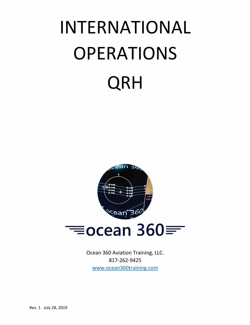
Rev. 1 July 28, 2019
INTERNATIONAL
OPERATIONS
QRH
Ocean 360 Aviation Training, LLC.
817-262-9425
www.ocean360training.com

1 Rev. 1 July 28, 2019
ARINC 424 “Short-hand” Coordinate Entries
In the North Atlantic, whole-degree coordinates are encoded with the
letter “N” to the right of the degrees. For example, 5060N represents
50N 060W.
Half-degree coordinates are encoded with the letter “H” to the left of
the degrees. For example, H5060 represents 5030’N 060W.
For operations in areas where the longitude is greater than 99W (such
as in the Pacific Ocean), the coordinates are encoded with the letter
“N” in between the latitude and longitude. For example, 50N160
represents 50N 160W.

2 Rev. 1 July 28, 2019
“Long-Hand” Coordinate Entries
For “long-hand” coordinates entry, most FMSs utilize the format found
on Jeppesen charts.
For example: N42 54.5 W008 25.7. FMSs don’t require the spaces in
between, so those coordinates should be entered: N4254.5W00825.7
Keep in mind that the decimal represents 10ths of a minute.
3 Rev. 1 July 28, 2019
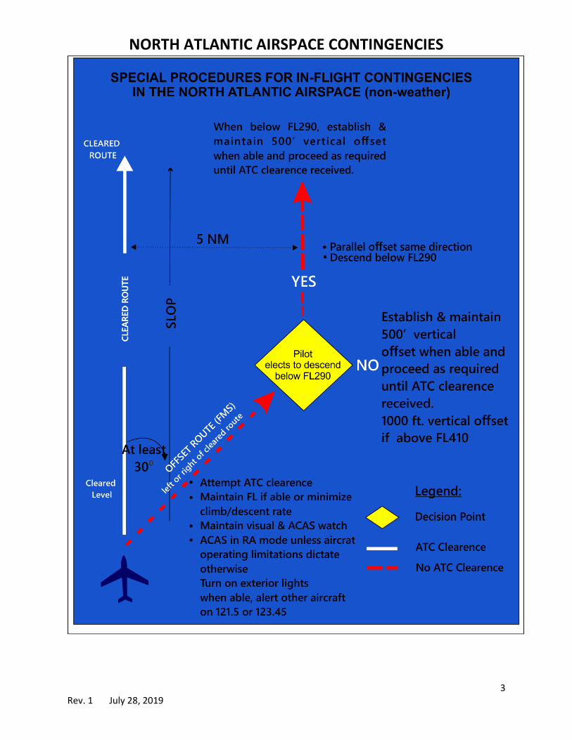
NORTH ATLANTIC AIRSPACE CONTINGENCIES
4 Rev. 1 July 28, 2019
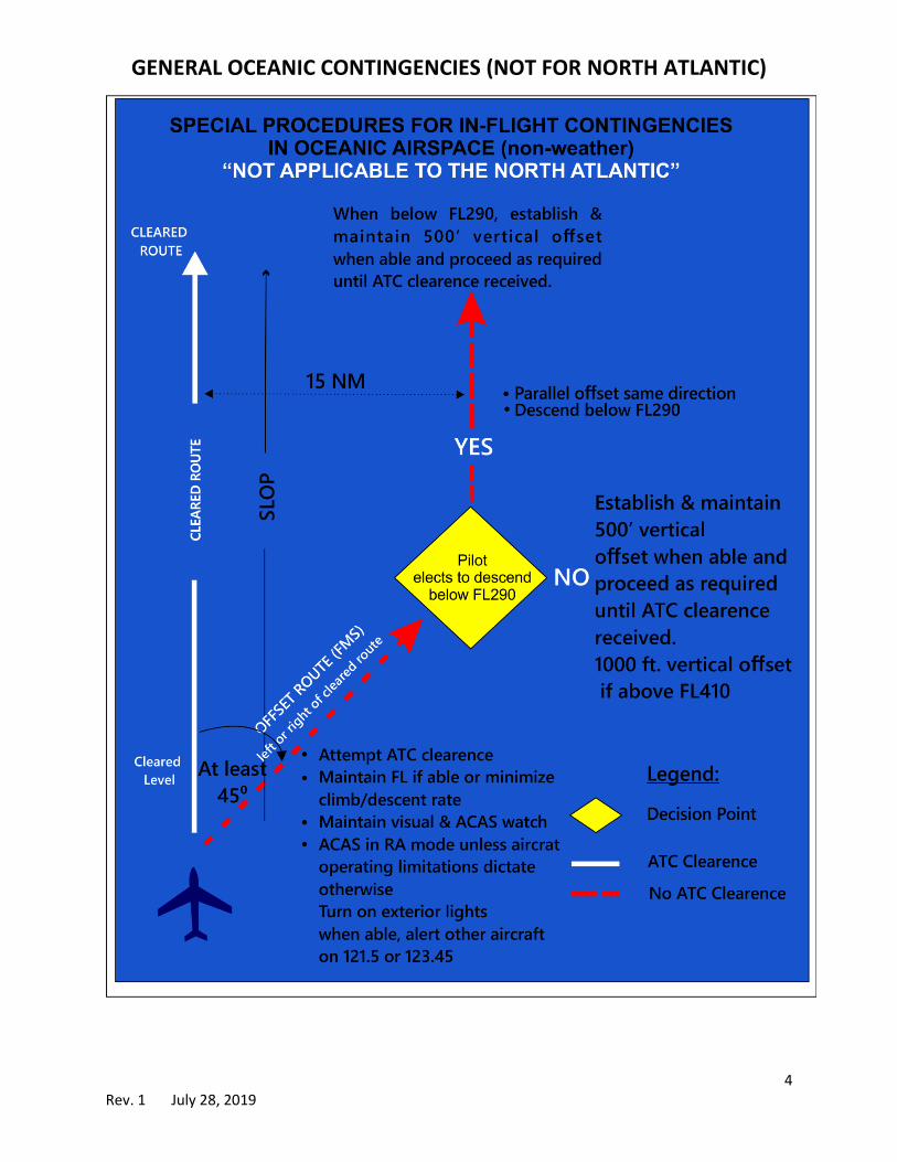
GENERAL OCEANIC CONTINGENCIES (NOT FOR NORTH ATLANTIC)

5 Rev. 1 July 28, 2019
Weather Deviations in the North Atlantic
Originally cleared track or
route centerline
Deviations > 5 NM Level Change
EAST
(000-179 magnetic)
LEFT
RIGHT
DESCEND 300’
CLIMB 300’
WEST
(180-359 magnetic)
LEFT
RIGHT
CLIMB 300’
DESCEND 300’
NOTE: For weather deviations not in the NAT, the distance at which
you must climb or descend is 10 NM.

6 Rev. 1 July 28, 2019
7 Rev. 1 July 28, 2019
8 Rev. 1 July 28, 2019

9 Rev. 1 July 28, 2019
SAMPLE OCEANIC CHECKLIST
FLIGHT PLANNING AFTER OCEANIC ENTRY
Plotting Chart-plot route Squawk 2000 - 30 minutes after entry
Equal Time points - plot Maintain assigned Mach
Track Message – Current copy VHF radios - set to 121.5 & 123.45
Plot relevant tracks SLOP
Hourly altimeter checks
PREFLIGHT
Maintenance Log- check for any nav APPROACHING WAYPOINTS
or communication/RVSM issues Confirm next waypoint
RVSM: Altimeter checks
CFP - label "MASTER DOCUMENT" OVERHEAD WAYPOINTS
CFP Vs ICAO flight plan: check route, Confirm aircraft transitions to next wp
fuel, times, BOW, equipment codes, ETP Check track & distance against Master
HF Check including SELCAL Record time to next wp
Master CFP (O, /, X) Record Fuel remaining
FMS programming: Record altimeter readings on chart & log
PM programs, PF verifies Make Position report (if applicable)
Check currency & software version
Independent verification 2˚ Of Longitude (10 min. after WP)
Track & Distance check Record time and lat/long on plot
UTC Time check
CPDLC pre-flight Setup
MIDPOINT
CLIMB OUT Midway between points compare
Record wheels up time winds from CFP
Transition Altitude - set QNE Confirm time to next waypoint
Manually compute ETAs
PRIOR TO OCEANIC ENTRY COAST IN
CPDLC Log On Remove SLOP
Change to "Manual" speeds (if applicable) Confirm domestic route
HF check - if not done prior Compare ground based NAVAID to FMS
Obtain oceanic clearance Change to "AUTO" speeds (if applicable)
Confirm and maintain correct FL at entry
Set TCAS to "BELOW"
Confirm FL, Mach and route for crossing DESCENT
Reclearance: update FMS, CFP, plotting Transition Level - Set QNH
Check track and distance for new route Confirm proper altimetry (Inches or hPa)
Altimeter Checks - record readings

10 Rev. 1 July 28, 2019
COMMUNICATIONS & NAVIGATION LOG
Date A/C Ident Capt/F.O.
ATC Clearance
Ground Position Position Position Position Position
Position
Time
Flt Level
Estimate (Pos)
At (time)
Next (Pos)
Primary freq.
Secondary freq.
Altimetry #1 #1 #1 #1 #1 #1
#2 #2 #2 #2 #2 #2
Stby Stby Stby Stby Stby Stby
Fuel Remaining
FMS 1 Position
FMS 2 Position
FMS 3 Position