International Geology Review Paleogene Extension in the...
20
PLEASE SCROLL DOWN FOR ARTICLE This article was downloaded by: [UNAM] On: 20 April 2010 Access details: Access Details: [subscription number 918398398] Publisher Taylor & Francis Informa Ltd Registered in England and Wales Registered Number: 1072954 Registered office: Mortimer House, 37- 41 Mortimer Street, London W1T 3JH, UK International Geology Review Publication details, including instructions for authors and subscription information: http://www.informaworld.com/smpp/title~content=t902953900 Paleogene Extension in the Southern Basin and Range Province of Mexico: Syndepositional Tilting of Eocene Red Beds and Oligocene Volcanic Rocks in the Guanajuato Mining District José Aranda-Gómez ;Fred Mcdowell To cite this Article Aranda-Gómez, José andMcdowell, Fred(1998) 'Paleogene Extension in the Southern Basin and Range Province of Mexico: Syndepositional Tilting of Eocene Red Beds and Oligocene Volcanic Rocks in the Guanajuato Mining District', International Geology Review, 40: 2, 116 — 134 To link to this Article: DOI: 10.1080/00206819809465201 URL: http://dx.doi.org/10.1080/00206819809465201 Full terms and conditions of use: http://www.informaworld.com/terms-and-conditions-of-access.pdf This article may be used for research, teaching and private study purposes. Any substantial or systematic reproduction, re-distribution, re-selling, loan or sub-licensing, systematic supply or distribution in any form to anyone is expressly forbidden. The publisher does not give any warranty express or implied or make any representation that the contents will be complete or accurate or up to date. The accuracy of any instructions, formulae and drug doses should be independently verified with primary sources. The publisher shall not be liable for any loss, actions, claims, proceedings, demand or costs or damages whatsoever or howsoever caused arising directly or indirectly in connection with or arising out of the use of this material.
Transcript of International Geology Review Paleogene Extension in the...
PLEASE SCROLL DOWN FOR ARTICLE
This article was downloaded by: [UNAM]On: 20 April 2010Access details: Access Details: [subscription number 918398398]Publisher Taylor & FrancisInforma Ltd Registered in England and Wales Registered Number: 1072954 Registered office: Mortimer House, 37-41 Mortimer Street, London W1T 3JH, UK
International Geology ReviewPublication details, including instructions for authors and subscription information:http://www.informaworld.com/smpp/title~content=t902953900
Paleogene Extension in the Southern Basin and Range Province of Mexico:Syndepositional Tilting of Eocene Red Beds and Oligocene Volcanic Rocksin the Guanajuato Mining DistrictJosé Aranda-Gómez ;Fred Mcdowell
To cite this Article Aranda-Gómez, José andMcdowell, Fred(1998) 'Paleogene Extension in the Southern Basin and RangeProvince of Mexico: Syndepositional Tilting of Eocene Red Beds and Oligocene Volcanic Rocks in the GuanajuatoMining District', International Geology Review, 40: 2, 116 — 134To link to this Article: DOI: 10.1080/00206819809465201URL: http://dx.doi.org/10.1080/00206819809465201
Full terms and conditions of use: http://www.informaworld.com/terms-and-conditions-of-access.pdf
This article may be used for research, teaching and private study purposes. Any substantial orsystematic reproduction, re-distribution, re-selling, loan or sub-licensing, systematic supply ordistribution in any form to anyone is expressly forbidden.
The publisher does not give any warranty express or implied or make any representation that the contentswill be complete or accurate or up to date. The accuracy of any instructions, formulae and drug dosesshould be independently verified with primary sources. The publisher shall not be liable for any loss,actions, claims, proceedings, demand or costs or damages whatsoever or howsoever caused arising directlyor indirectly in connection with or arising out of the use of this material.
International Geology Review, Vol. 40, 1998, p. 116-134. Copyright © 1998 by V H. Winston & Son, Inc. All rights reserved.
Paleogene Extension in the Southern Basin and Range Province of Mexico: Syndepositional Tilting of Eocene Red Beds and Oligocene Volcanic Rocks in the Guanajuato Mining District
JOSE JORGE ARANDA-GÓMEZ Unidad de Ciencias de la Tierra (UNICIT), Instituto de Geología, Universidad Nacional Autónoma de México,
P.O. Box 1-742, Santiago de Querétaro, Qto. 76001 Mexico
A N D FRED W. M C D O W E L L
Department of Geological Sciences, The University of Texas at Austin, Austin, Texas 78712
Abstract
The Guanajuato region, located in the southern part of the Basin and Range tectonic province, is characterized by a rhombohedral fault pattern. Extensional faulting—as well as related uplift, erosion, and deposition of continental clastic deposits—was in progress at 49 Ma, as indicated by K-Ar dating of intercalated mafic volcanic lavas. Earliest extension is registered in the lower member of the Guanajuato conglomerate and produced NW-trend-ing, down to the southwest, normal faults and northeast tilting of the hanging-wall clastic sequence. Beds in the upper member of the Guanajuato conglomerate display lateral thickness variations, changes in size and composition of the clasts, and ENE and SE inclination, all of which suggest activity along a second set of NE-trending younger faults. Extension continued also after emplacement of the overlying Bufa ignimbrite (~37 Ma, K-Ar). Dip differences between the conglomerate and the Calderones Formation (<37 but >30 Ma), which is part of the volcanic sequence that conformably overlies the Guanajuato conglomerate, indicate at least 13° and probably more than 20° of rotation prior to 37 Ma. Consistent northeast tilting in the Calderones Formation indicates that subsequent extension preferentially reactivated the NW-trending faults. This sequence of deformational events produced the rhombohedral fault pattern observed in the region. Later pulses of extension (late Oligocene and younger) produced simultaneous movement on both sets of faults, as suggested by others.
In addition to this strong evidence for Paleogene extension in the Guanajuato region, indication of Paleogene extension also may be present at scattered localities throughout central and southern Mexico, where continental red beds occur stratigraphically between pre-Cenozoic rocks and Tertiary volcanic rocks (Eocene-Oligocene). Detailed structural and stratigraphic data are lacking for these localities, but they may provide an important record of a regional Paleogene extension episode that has been largely overshadowed by the obvious evidence for extension during the Neogene.
Introduction
T H E SOUTHERN BASIN AND R A N G E PROVINCE
of N o r t h America stretches sou thward at least to the Guanajuato region (Fig. 1A) and p r o b a b l y t o t h e G u e r r e r o a n d O a x a c a reg ions in s o u t h e r n M e x i c o (Henry and A r a n d a - G ó m e z , 1 9 9 2 ; Jansma and Lang, 1997; Stewart et a l , 1996). In addition to the existence of the normal faults themselves, the
record of Neogene extension includes coarse, cont inenta l ly der ived clastic sed imenta ry rocks tha t were depos i ted synchronous ly with the formation of linear, fault-bounded bas ins ( M c D o w e l l e t a l . , 1 9 9 7 ; N i e t o -Samaniego , 1 9 9 0 ; N i e t o - S a m a n i e g o and A r a n d a - G ó m e z , 1 9 9 1 ) . A l t h o u g h the se deposits did not all form during the same time interval, they all post-date e rupt ion of
0020-6814/98/312/116-19 $10.00. 116
Downloaded By: [UNAM] At: 00:33 20 April 2010

GUANAJUATO MINING DISTRICT 1 1 7
FIG. 1. A. Late Cenozoic normal faults of the southern Basin and Range province in northern and central Mexico. The most obvious structures occur north of the Trans-Mexican Volcanic Belt (TMVB). Some faults in the Oaxaca and Guerrero region have been interpreted as part of the same province (Henry and Aranda-Gómez, 1992; Jansma and Lang, 1997). B. Outcrops of Eocene continental conglomerates and volcanic rocks in central and southern Mexico. Localities shown: 1 = Nazas (Aguirre and McDowell, 1991); 2 = Velardeña (Gilmer et al., 1988); 3 = Colorada (Albinson, 1988); 4 = Sombrerete (Albinson, 1988); 5 = Fresnillo (Lang et al., 1988); 6 = Zacatecas (Ponce and Clark, 1988); 7 = La Herradura (Labarthe-Hernández and Jimenez-Lopez, 1991); 8 = Ahualulco (Labarthe-Hernández et al., 1982, 1995); 9 = Pinos (Aguillón-Robles et al., 1994); 10 = Juchipila (Webber et al., 1994); 11 = Comanja (Martínez-Reyes, 1992); 12 = Providencia (Tristan-Gonzalez, 1986); 13 = Guanajuato (this paper); 14 = Tzitzio (Pasquaré et al., 1991); 15 = Taxco (De Cserna and Fries, 1981; Alba-Aldave et al., 1996); 16 = Tetela del Río (Pantoja-Alor, 1983); 17 = Tetelcingo (Pantoja-Alor, 1983); 18 = Tamazulapan (Ferrusquía-Villafranca, 1976); 19 = Zimapán (Simons and Mapes, 1957; Yta and Moreno-Tovar, 1997); 20 = Arcelia (Jansma and Lang, 1997).
Downloaded By: [UNAM] At: 00:33 20 April 2010

118 ARANDA-GÓMEZ AND MCDOWELL
voluminous felsic rocks in late Eocene and Oligocene time.
Isolated outcrops of coarse clastic red beds of Eocene age occur throughout much of central and southern Mexico (Fig. 1B; Table 1). These deposits rest unconformably upon folded Mesozoic rocks and underlie the late Eocene and Oligocene felsic volcanic rocks. Fragments derived from Mesozoic marine rocks are the dominant clasts in most localities, but almost invariably a small proportion of volcanic clasts and/or intercalated lavas and tuffs is present (e.g., Schulze, 1953; Simons and Mapes, 1957; Enciso de la Vega, 1963, 1968; McLeroy and demons, 1965; Clemons and McLeroy, 1966; Ledezma-Guerrero, 1967; Mayer Pérez Rul, 1967; De Cserna and Fries, 1981; Labarthe-Hernández et al., 1982; Labarthe-Hernández and Jimenez, 1991; Aguillón-Robles et al., 1994; Yta and Moreno-Tovar, 1997; Jansma and Lang, 1997). These lower Tertiary conglomerates have been interpreted as molasse deposits that accumulated passively within topographic lows during the last phases of or immediately after the Laramide orogeny (e.g., Tardy, 1980), and/or as fanglomerates d e p o s i t e d near active no rma l faults (Edwards, 1955; De Cserna and Fries, 1981; De Cserna, 1989; Yta and Moreno-Tovar, 1997; Jansma and Lang, 1997).
The southernmost part of the Mesa Central of Mexico (Raisz, 1964), which forms part of the southern Basin and Range province (Henry and Aranda-Gómez, 1992), is covered by a thick sequence of middle Ceno-zoic volcanic rocks (Labarthe-Hernández et al., 1982). This subaerial sequence rests on folded Mesozoic marine sediments and/or early to middle Tertiary continental clastic deposits (e.g., the Guanajuato conglomerate [Edwards, 1955] , Cenicera Formation [Labarthe-Hernández et al., 1982], Duarte conglomerate [Martinez-Reyes, 1992]). The volcanic rocks cover a large portion of the region located between Guanajuato and San Luis Potosí. They are cut by numerous Ceno-zoic faults with two prominent orienta
tions—northwest and northeast (Fig. 2). A compilation of the attitude (strike and dip direction and amount of dip) of stratified Cenozoic rocks and their relation to known faults in the region has shown that most (over 90%) of the outcrops of Eocene continental conglomerates and Oligocene ignimbrites are tilted toward the northeast (Stewart et al., 1996). Qualitative observations made while compiling this regional tilt-domain map suggest that the average dip of the Eocene red beds is significantly larger than the inclination of the Oligocene ignimbrites, despite the fact that in Guanajuato the contact between both sequences is concordant. These relations are consistent with growth faulting and associated rollover folds that result in a section in which stratal dips progressively decrease upward.
This paper attempts to document and quantify the tilt difference between the Eocene and Oligocene strata and to interpret its significance. We have chosen to examine this relationship in the Guanajuato mining district, because Eocene and Oligocene stratified rocks occur together there, and because significant structural observations have been made that can be compiled and critically analyzed for this effect. In our analysis we assume that: (1) both the Eocene fanglomerates and tabular bodies within the volcanic sequence (ignimbrites and epiclastic volcanic deposits) were nearly horizontal (≤ 10° of depositional dip) when deposited; and (2) subsequent tilting is related to normal faulting. Evidence of compressional deformation is absent from the Tertiary rocks of the region.
Guanajuato Mining District
The Guanajuato mining district contains the most prominent outcrop of Eocene continental conglomerates within the southern part of the Mesa Central. In the eastern part of the district, the contact between the Guanajuato conglomerate and the overlying vol-
Downloaded By: [UNAM] At: 00:33 20 April 2010

GUANAJUATO MINING DISTRICT 1 1 9
TABLE 1. Isotopic Ages of Some Early Tertiary Conglomerates in Central and Southern Mexico
Locality1
Guanajuato mining district (13)
Nazas, Durango (1)
Juchipila, Zacatecas (10)
Tetela del Río, Guerrero (16)
Taxco mining district (15)
Tetelcingo, Guerrero (17) Ahualulco, San Luis Potosí(8) Zacatecas mining district (6) Fresnillo mining district (5) Colorada (3) and Sombre-rete (4) mining districts
Velardeña mining district (2) Zimapán mining district (19) Mixteca Alta (18)
Arcelia graben (20)
Stratigraphic unit
Guanajuato conglomerate
Ahuichila Fm.
Red sandstone and conglomerate
Balsas Fm.
Balsas/More-los Fm.
Tetelcingo Fm.
Cenicera Fm.
Zacatecas red conglomerate
Fresnillo Fm.
Ahuichila Fm.
Ahuichila Fm.
El Morro Fm.
Tamazulapan conglomerate
Balsas Fm.
Lat., °N
20.98
25.21
21.65
18.03
n.r. 3
17.91
22.27
n.r.
n.r.
n.r.
17.42
n.r.
Long.,
101.29
104.19
103.08
100.12
n.r.
99.51
101.17
n.r.
n.r.
n.r.
97.29
n.r.
Age, Ma
49
>43
48-24
42
>38
52
>44
>47
>38
>53?
>45
>38
>49
42
Method
K-Ar w.r.4
K-Ar Plag, bio
K-Ar (48 feldspar,
24 w.r.) K-Ar w.r.
K-Ar w.r.
K-Ar w.r. K-Ar w.r.
K-Ar? Bio
K-Ar
K-Ar K-spar
K-Ar
K-Ar
Pb-α
K-Ar
Dated stratigraphic unit
Age of andesitic lava flows interbedded with lower member
Average isotopic age of the overlying Boquillas Coloradas tuff Age of clastic sequence is bracketed by basaltic andesites
Age of olivine basalt interlayered with red beds
Age of vitrophyre in the lower part of the overlying Acamixtla formation Age of basalt interlayered with Balsas Fm. Age of overlying Casita Blanca andesite Oldest isotopic age in overlying volcanic sequence Oldest isotopic age in overlying volcanic sequence Age of overlying (?) dacite porphyry
Age of overlying andesite
Oldest isotopic age in overlying volcanic sequence Isotopic age detemined in interlayered tuffs in the overlying Yanhuitlán Fm. Interlayered basalt. Probably the age reported by Pantoja-Alor, 1983 (locality 16)
Source2
a
b
c
d
h
d
i
e
f
f
g
i
k
I
1 Numbers in parentheses correspond to locality numbers in Figure 1. 2Sources: a = this paper; b = Aguirre and McDowell, 1991; c = Webber et al., 1994; d = Pantoja-Alor, 1983; e = Ponce and Clark, 1988; f = Albinson, 1988; g = Gilmer et al., 1988; h = Alba-Aldave et al., 1995; i = Labarthe et al., 1982; j = Yta and Moreno-Tovar, 1997; k = Schlaepfer et al., 1974, Ferrusquía-Villafranca, 1976; 1 = Jansma and Lang, 1997. 3n.r. = not reported. 4w.r. = whole-rock.
Downloaded By: [UNAM] At: 00:33 20 April 2010

1 2 0 ARANDA-GÓMEZ AND McDOWELL
FIG. 2. Regional geology of the area between Guanajuato (G) and San Luis Potosí (SLP). Other abbreviations: S = Salinas de Hidalgo; SF =San Felipe; DH = Dolores Hidalgo; L = León; SM = San Miguel de Allende; VM =Veta Madre; AF = Aldana fault. Note that south of latitude 22°30' N, most of the area is covered by Cenozoic volcanic rocks. Most stratified Eocene fanglomerates and Oligocene volcanics are tilted to the northeast. Inset shows a rose diagram of orientation of the Cenozoic faults in the San Luis Potosí and Guanajuato 1:250,000 quadrangles. Sections A-A' and B-B' are diagrammatic and intended only to show the Cenozoic faulting style. Cenozoic volcanic rocks were grouped in a single unit. Modified from Nieto-Samaniego et al. (1997a), Stewart et al. (1996), and Ortega-Gutierrrez et al. (1992).
canic sequence is conspicuously marked by the water-deposited volcaniclastic sandstones of the Losero Formation (Echegoyén-Sánchez et al., 1970), called "Bufa sandstone" by Edwards (1955). Field observations indicate that there is no significant angular unconformity at this contact. The Losero Formation forms the base of the volcanic section and is succeeded upward in order by the Bufa, Calderones, Cedro, and Chichíndaro formations (Echegoyén-Sanchez et al., 1970). Within the mining district the Calderones Formation is ~200 m thick and is composed of andesitic ignimbrites interbed-ded with volcaniclastic sediments. Isotopic
ages for the volcanic section (Table 2) are known from the Bufa ignimbrite (K-Ar = 37± 3 Ma [Gross, 1975]) and the Chichíndaro rhyolite (K-Ar = 32 ± 1 Ma [Gross, 1975]; K-Ar = 30.8 ± 0.8 Ma, 30.1 ± 0.8 Ma [Nieto-Samaniego et al., 1997c]).
The general distribution and attitude of both the Guanajuato conglomerate and the Calderones Formation, and the overall structural relations of these units with syn- and post-volcanic faults, have been carefully documented in several publications (Edwards, 1955; Echegoyén-Sánchez et al., 1970; Nieto-Samaniego, 1990; Martinez-Reyes, 1992; Nieto-Samaniego et al., 1997c). On
Downloaded By: [UNAM] At: 00:33 20 April 2010

GUANAJUATO MINING DISTRICT 1 2 1
TABLE 2. Available K-Ar Ages for the Tertiary Section in the Guanajuato Mining District
Unit
Chichíndaro rhyoiite
Same
Same
Bufa rhyoiite
Guanajuato conglomerate
Mineral
Sanidine
Sanidine
??
??
w.r.2
Lat., °N
21.08
20.89
n.r.3
n.r.
20.98
Long., °W
101.02
101.17
n.r.
n.r.
101.29
% K
8.426 8.590
8.191 8.482
-_
1.242 1.220
40*Ar, %
78 92 72
77 80
--
82 82
40*Ar4
10.26 9.77
10.08
10.17 9.94
--
2.381 2.404
Age, Ma ± 1σ
30.1 ± 0.8
30.8 ± 0.8
32.1 ± 1.0
37.0 ± 3.06
49.3 ± 1.0
Reference5
Nieto-Sarnaniego et al., 1997c
Nieto-Samaniego et al., 1997c
Gross, 1975
Gross, 1975
This work
1Samples are listed in stratigraphic order, from youngest to oldest. Decay constants: λß = 4.962 x 10⁻¹⁰/yr; λε+ε = 0.581 × l0-10/yr; 40K/K=1.167 × 10-4. 2w.r. = whole rock. 3n.r. = not reported. 4Units are × 10-6 cc STP for radiogenic argon (40*Ar). 5Gross (1975) included no analytical data for his results. 6Gross quotes this error as 3.0 and 0.3 Ma.
the basis of these structural data, the Guanajuato mining district is the region of the southern part of the Mesa Central where structural relations among the Eocene red beds and the Oligocene volcanics can best be analyzed and interpreted.
The Guanajuato Conglomerate
The following summary of the geology of the red-bed sequence exposed in the Guanajuato mining district is based on the work by Edwards (1955). The ~1500 m thick sequence of lower Tertiary red beds exposed near the city of Guanajuato is interpreted as coalescing alluvial fans deposited at the base of a fault-bounded mountain block. From clast size distributions, it is believed that the source area for the conglomerate was located a short distance (<10 km) northeast of Guanajuato. A disconformity mapped in the clastic sequence separates two distinct members
that display different textures and clast compositions.
The lower member is formed by red and brown sandstones, in places intercalated with intermediate to mafic lavas (i.e., "old volcanic rocks" in Edwards's map) and conglomerate beds. The upper member is a sequence of boulder beds that grade upward to pebble conglomerates. Volcanic fragments are the most abundant clast type (up to 76%) in both members. There is a significant increase in the proportion of granitic clasts (up to 28%) above the disconformity, indicating progressive unroofing of older rocks in the highland source area. According to Edwards, the disconformity between the upper and lower members represents a "hiatus of unknown, but probably considerable time ... [and] the absence of channeling, or observable angular discordance [between the upper and lower member]... indicates that little or no erosion occurred... .The great influx of coarse granite conglomerate immediately above the disconformity is considered a result of reju-
Downloaded By: [UNAM] At: 00:33 20 April 2010

1 2 2 ARANDA-GÓMEZ AND MCDOWELL
FIG. 3. Distribution of Eocene red beds in part of the Guanajuato mining district. Stereoplots (A-D) show the dip direction of the beds in the conglomerate, projected into the lower hemisphere. The data set was compiled from the l:20,000-scale geologic map of Edwards (1955).
venated normal faulting along the margin of the highland source" (Edwards, 1955, p. 160).
Abrupt changes in the thickness from 650 to 170 m of the upper member and its relation to the NE-trending Amparo fault (Fig. 3) suggest that faulting was active during deposition of the upper member of the conglomerate. Movement along the Amparo fault continued after deposition of the Bufa ignim-brite, as this unit is cut by the fault northeast of the town of Guanajuato. Post-Bufa activity produced less than 30 m of throw northeast of the town of Guanajuato, compared with 500 m of displacement in the area east of Marfil (Fig. 3). In the eastern part of the Guanajuato district, the upper contact
between the red beds and the overlying volcanic sequence is conformable. The transition between the poorly sorted and relatively coarse grained red beds in the upper part of the polymictic conglomerate and the green, medium-grained, finely laminated volcani-clastic sandstones of the Losero Formation is only a few centimeters thick. Therefore, at least in those places where Losero accumulated, the upper surface of the conglomerate must have been nearly horizontal at the time of deposition of the tuff. Nowhere in the district has a basal depositional contact of the red beds upon the underlying Mesozoic rocks been observed. The two units are everywhere in fault contact in the western part of the district (e.g., along the Aldana fault, Fig. 3).
Downloaded By: [UNAM] At: 00:33 20 April 2010

GUANAJUATO MINING DISTRICT 123
Age of the Guanajuato Conglomerate
There are two sources of information that provide age control on the deposition of the Guanajuato conglomerate—vertebrate fossils and isotopic ages. The vertebrate fossils of the Marfil local fauna, formed by rodents, lizards, and a tapir-like mammal found by Edwards (1955, p. 171) and Fries et al. (1955) in the lower member of the conglomerate, are most probably of late Eocene age, but may range from late early Eocene to post-early Oligocene. The discovery of a miacid carnivore (Viverravus sp.) and a condylarth hyopsodontid (Apheliscus or Haplomylus) in the lower member of the conglomerate suggests a middle to late Eocene age (Ferrusquia-Villafranca, 1987). More precise control is provided by a whole-rock K-Ar age of 49.3 ± 1.0 Ma (Table 2) on a basalt from the south-westernmost exposures of the conglomerate, sampled ~2.5 km southwest of Marfil (Fig. 3). At the sampled locality, the basalts were mapped by Edwards as the "old volcanic rocks," which he describes as interlayered within the conglomerate unit (Edwards, 1955, his Fig. 18, p. 156). The K-Ar and fossil ages only define individual time points during deposition of the lower member of the Guanajuato conglomerate. They do not specify the full time interval of sedimentation. An upper limit is provided by the 37 ± 3 Ma K-Ar age from the overlying Bufa Formation (Gross, 1975). Unfortunately, this age has a rather large uncertainty. Clearly, additional geochronology is warranted, both from within the Guanajuato conglomerate and from its bounding units.
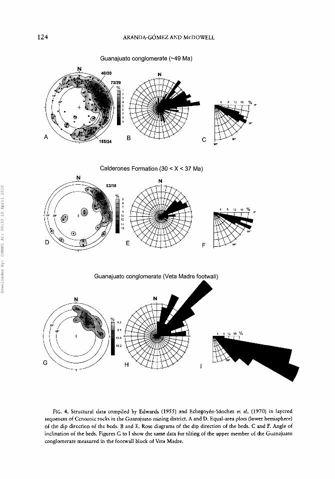
Tilting in Cenozoic Rocks of the Guanajuato District
On their 1:20,000- and l:10,000-scale geologic maps, Edwards (1955) and Eche-goyén-Sánchez et al. (1970), respectively, plotted structural attitudes of beds in the Guanajuato conglomerate (n = 328) and the Calderones Formation (n = 43). These are
displayed separately in Figure 4 as lines of dip direction projected onto the lower hemisphere of equal-area plots. The data for the Guanajuato conglomerate display considerable dispersion, but a large number of measurements are located in the eastern half of the diagram, along a broad belt that extends from 330° to 185° (Fig. 4A). Three clusters of points occur along this belt at 040˚/30˚, 073˚/29˚, and 155˚/24˚. A rose diagram of the azimuths of the dip directions (Fig. 4B) clearly shows that most beds in the Guanajuato conglomerate are inclined toward the NE and ENE, and the inclination diagram (Fig. 4C) depicts the range in tilt angle of the conglomerate from 75° to 4°, with most beds inclined between 35° and 20°.
In contrast, the data from the Calderones Formation are less dispersed; the dip directions concentrate in the northeast quadrant of the diagram, along a belt that extends from 030° to 095° (Fig. 4D). The belt contains a single maximum at 053718°. The dip directions (Fig. 4E) cluster between 040° and 070°, with a concentration cluster at 055°. The dip angles range from 75° to 9°, with most beds inclined between 25˚ and 10˚ (Fig. 4F). One problem in comparing these structural data is that the measurements from the two formations are predominantly from two structural blocks separated by the Veta Madre fault. To overcome this problem, a subset of 22 measurements from beds of the Guanajuato conglomerate that are from the same tectonic domain as most of the those from the Calderones Formation are plotted in Figures 4G through 41. Although these data show only a single mode of dip direction for the Guanajuato conglomerate, the mean inclination is comparable to that for the full data set and is significantly larger than that for the Calderones Formation,
In order to further evaluate the dispersion of the structural data for the Guanajuato conglomerate, the data were plotted separately for its two members (Fig. 5). Despite the lack of an obvious angular unconformity between them, the orientation of the tilted beds varies
Downloaded By: [UNAM] At: 00:33 20 April 2010
1 2 4 ARANDA-GÓMEZ AND MCDOWELL
FIG. 4. Structural data compiled by Edwards (1955) and Echegoyén-Sánchez et al. (1970) in layered sequences of Cenozoic rocks in the Guanajuato mining district. A and D. Equal-area plots (lower hemisphere) of the dip direction of the beds. B and E. Rose diagrams of the dip direction of the beds. C and F. Angle of inclination of the beds. Figures G to I show the same data for tilting of the upper member of the Guanajuato conglomerate measured in the footwall block of Veta Madre.
Downloaded By: [UNAM] At: 00:33 20 April 2010

GUANAJUATO MINING DISTRICT 1 2 5
FIG. 5. Structural data compiled by Edwards for the lower (A) and upper (B) members of the Guanajuato conglomerate. Equal-area plots (lower hemisphere) show the dip direction of the beds.
significantly between the two members. The data for the lower member define a broad belt that occupies part of the northwestern and entire northeastern quadrant of the diagram (Fig. 5A), with the most significant concentration of points around 042°/29°. In contrast, the data points for the upper member of the Guanajuato conglomerate cluster in the northeastern and southeastern quadrants, and the distribution is bimodal, with maxima at 080˚/25˚ and 155˚/24˚ (Fig. 5B).
In Figures 3A-3D the tilt data are separated geographically to evaluate the influence of large syn- to post-depositional ENE-trend-
ing structures, such as the Amparo and Rocha faults. The data for both members are plotted separately for localities northeast and southwest of these major structures. For the lower member, the only significant difference is a small rotation toward more easterly inclinations to the north of the Rocha fault (Figs. 3A and 3B). In contrast, the upper member displays marked differences across the Amparo fault. Dip directions for beds located north of the fault are 080° (Fig. 3C), whereas those for beds located south of the structure are bimodally distributed, with distinct clusters at 080° and 155° (Fig. 3D). Inspection of Edwards's map indicates that most SE-dip-ping beds occur near the southeastern corner of the mapped area, which also is the outcrop limit of the red beds in the area.
Subdividing the data in this manner revealed that the steepest dips, and most SW-dipping beds, occur in the lower member and near the trace of the Aldana fault, which is NE-trending, down to the southeast, and post-dates deposition of the conglomerate (Fig. 3). The largest dip angles might be related to more pronounced tilting in the older member of conglomerate and/or drag near the Aldana fault.
Discussion
Early extension in Guanajuato A prolonged period of Cenozoic extension
in the area around Guanajuato began as early as the middle Eocene (~49 Ma) and probably continued until the Late Cenozoic (Nieto-Samaniego et al., 1997a, 1997b). Whether extension was continuous or occurred as discrete phases separated by long quiescent periods is unknown. The lower and upper members of the Guanajuato conglomerate were preferentially tilted toward the NE and ENE, respectively, as they were being deposited (Fig. 5). There is a significant difference (>13°) between the mean tilt angle of the Guanajuato conglomerate and that for the overlying volcanic sequence, represented
Downloaded By: [UNAM] At: 00:33 20 April 2010

126 ARANDA-GÓMEZ AND McDOWELL
TABLE 3. Summary of Tectonic and Depositional Events Inferred from the Study of the Guanajuato Conglomerate and Calderones Formation
Calderones Formation
Faulting and tilting
Deposition
Guanajuato conglomerate
Upper member
Faulting and tilting
Deposition
Lower member
Faulting and tilting
Deposition
PULSE 1
— N E — ______
PULSE 2
— S E — ___
— S E —
PULSE 3
?__NE__
__NE___
— N E —
by data from the Calderones Formation (Fig. 4). The lack of an angular unconformity between these two sequences suggests that faulting and tilting continued while the volcanosedimentary sequence was being deposited.
Structural data collected from the lower member of the conglomerate indicate that during the earliest pulse of Cenozoic normal faulting, extension was probably in a NE-SW direction and produced a large NW-trending fault zone (Table 3), which caused the northeast tilting in the sequence. As was pointed out by Edwards (1955), the fault-bounded mountain front, which acted as the source region for the lower member of the fanglom-erate, was located northeast of the Guanajuato mining district. Thus, the lower member is tilted toward this fault.
The disconformity between the upper and lower members of the conglomerate signals a change in the style of deformation and possibly in the source for sediments to the depositional basin. A clear bimodal distribution of the dip direction in the upper member is seen south of the Amparo fault (Fig. 3). Although the largest concentration of data points still
lies within the northeastern quadrant, the maximum occurs around 080°, compared with 042° in the lower member (Fig. 5). Both the marked change in thickness of the upper member of the conglomerate (Edwards, 1955) and the inclination of the beds toward the ENE and SE suggest that another group of faults, oriented in a NE-SW direction, became active during a second phase of extension, possibly together with continued activity along the NW-trending set of normal faults (Table 3). The best examples of these NE-trending structures are the Amparo and Rocha faults in the Guanajuato mining district (Fig. 3). The concentration of beds dipping by as much as 25° to the southeast in the southern part of Figure 3 suggests that an important NE-trending structure, down to the northwest, was located to the south of Guanajuato.
Later extension occurred during (?) and after the deposition of the Calderones Formation (Table 3). This pulse caused tilting of the sequence toward the northeast. Dip directions and angles for the Calderones Formation cluster around 053°/18° (Fig. 4D). Additional dispersion arose from extension
Downloaded By: [UNAM] At: 00:33 20 April 2010

GUANAJUATO MINING DISTRICT 127
that occurred after deposition of the volcanic sequence (e.g., Nieto-Samaniego, 1990). Movement along numerous younger faults with variable orientations (see inset in Fig. 2) probably produced local rotation of the beds.
Aside from these major changes in the pattern of tilting, some of the structural dispersion displayed in Figures 4 and 5 may be related to variation in primary dip directions in the fanglomerate. It is possible that the discontinuous beds in the original alluvial fan deposit radiated away from the apex of the fan. Furthermore, it is very likely that the conglomerate was formed by coalescence of an unknown number of alluvial fans, each one with its own radial pattern.
In order to estimate the amount of rotation that occurred prior to deposition of the Calderones Formation, we have assumed that the maxima in the data of Figures 4 and 5 are representative of the average tilt angles and dip directions for beds of the lower and upper members of the conglomerate and the Calderones Formation. We further assume that the ignimbrites and volcaniclastic rocks of the Calderones Formation originally were horizontal. After rotating the Calderones to horizontal from its average tilt value, an inclination of 13° toward the northeast remains for the absolute maximum orientation of the conglomerates. We regard this figure as a minimum value for the amount of pre-Cal-derones (>37 Ma) rotation. Because it is very likely that the gravels in the active alluvial fans had a primary dip of approximately 5° to 9° away from the source area {i.e., toward the southwest), additional pre-Calderones tilting probably is required. We infer that extension-related rotation of at least 20° ± 2° occurred prior to 37 Ma in the Guanajuato mining district. This analysis does not include the possible effect of rollover folding during deposition of sediments on the hanging-wall blocks of the faults. Thus, pre-Calderones tilting could be even greater. In such a case, fanning in the deposit would produce steeper northeastern inclinations in the older
strata than in the younger beds (Figs. 3 and 5).
Synthetic model for tilting of the Guanajuato conglomerate
Our interpretation of the structural data indicates that the Guanajuato conglomerate and Caiderones Formation record a complex tectonic and depositional history, which is summarized in Table 3. We have attempted to simulate this pattern with a simple computer model. For the lower member of the Guanajuato conglomerate, we assigned an initial dip-direction data set that represents an alluvial-fan deposit that accumulated at the base of a fault-bounded, 310°-trending mountain range (Figs. 6A and 6B). We assigned primary dips between 5° and 9° away from the mountain front (i.e., toward the southwest). Depositional dip directions were distributed in a fan array from 130° to 310°, with a gradual concentration of data points toward the depositional axis of the fan (i.e., 220°). Figures 6C, 6D, and 6E show the results of sequential tilting (20°, 10°, and 18°) of the data along 310°, 040°, 310° horizontal axes, respectively, which ultimately produces rotation of the maximum in the cluster to the northeastern quadrant while preserving a unimodal distribution. This exercise approximately reproduces the field data for the lower member of the conglomerate (Fig. 5A), except that the direction of the maximum concentration of points in the model is at least 20° east of that for the real data set. This could reflect either initial deposition/tilting along a more westerly fault during the first phase of deformation and/or tilting of the data set along a more northerly rotation horizontal axis during the second phase. Nevertheless, we restricted our parameters within a reasonable angular distance (± 20°) from the regional trends of the Cenozoic faults observed in the Mesa Central (see inset in Fig. 2).
For the upper member of the conglomerate (Fig. 5B), which has a bimodal distribution of the field data, we added a second data
Downloaded By: [UNAM] At: 00:33 20 April 2010

1 2 8 ARANDA-GÓMEZ AND MCDOWELL
FIG. 6. Results of computer simulation of simultaneous deposition and tilting of the lower member of the Guanajuato conglomerate. A. Map view of the source area, NW-trending normal fault, and alluvial fan. B. Initial conditions. Attitude of the beds in the ideal fan deposit are shown as dip directions. C. Model after 20° rotation along a 310°-trending horizontal axis (Phase 1, Table 3). Rotation was accomplished in 5° increments. Formation of the rollover fold in the sedimentary sequence of the hanging wall was simulated by addition of the original data set after each rotation. D. Model after 10" rotation of (C) along a 040°-trending horizontal axis (Phase 2, Table 3). E. Final result after 18" rotation along a 310°-trending horizontal axis (Phase 3, Table 3). All diagrams show dip directions projected onto the lower hemisphere.
set to represent an alluvial fan deposited along a 040°-trending, fault-bounded mountain front (Figs. 7A and 7B). The initial bimo-dal d is t r ibut ion reflects s imultaneous deposition of alluvial fans in a basin bounded by two nearly orthogonal source areas, similar to that observed in the field data for the upper member of the conglomerate (Fig. 5B). This enlarged data set then was sequentially rotated 10° and 18° along 040° and 310° horizontal axes, respectively. These rotations reduce the dispersion of the dip direction lines, causing the data to cluster around a single maximum (Figs. 7C and 7D). This second
model fails to produce the bimodal distribution and predicts a maximum concentration (045˚/18˚) north of the highest concentration of points (080˚/25˚) observed in the upper member of the conglomerate (Figs. 5B and 7D). Small variations (10°) in the orientation of the rotation axes produce significant shifts in the location of the maximum (Fig. 7E).
The effect of the formation of syntectonic rollover folds as the sedimentary sequence accumulated in the hanging wall of the active faults also was explored. For the lower member of the Guanajuato conglomerate, we pro-
Downloaded By: [UNAM] At: 00:33 20 April 2010

GUANAJUATO MINING DISTRICT 129
duced the initial 20˚ of northeast tilting in 5° steps, adding a new set of SW-dipping beds in each step. For the upper member, we likewise rotated the data set in 5° steps, adding each time the initial data set. The results of simultaneous deposition and rotation is to maintain the dispersion in the data (Figs. 6C and 7C). However, after simulation of the deposition ends, subsequent rotations of the data set tend to increase the clustering of data (Figs. 6D-6E and 7D).
Origin of the rhombohedral pattern of Cenozoic faults in the Mesa Central
This simple simulation of three pulses of alternating NE-SW, NW-SE, and NE-SW extension appears to successfully produce some of the structural and sedimentological features observed. Of course, it is the simplest approximation to the pattern of faulting in the district, inasmuch as it includes sequential activation of nearly orthogonal sets of dip-slip faults and rotation around horizontal axes parallel to those faults. The possibility of simultaneous movement/rotation and/or oblique-slip movement during the second and third pulses of deformation (Table 3) was not considered.
Nieto-Samaniego et al. (1997a, 1997b) pointed out that the regional fault pattern observed in the southern part of the Mesa Central was produced by triaxial deformation during the late Oligocene. Simultaneous dip-slip movement along NE- and NW-trending fault systems requires that at least one of the fault trends already existed. Once two sets of normal faults are present, younger extension can simultaneously activate both sets. Earlier tilting of both the red beds and in the Eocene-Oligocene volcanic sequence suggests that the early pulses of extensional deformation were biaxial.
Speculation about the regional extent of the early extension in Mexico
It seems clear, at least for the Guanajuato district, that deposition of Paleogene conglomerates was related to active extension.
Jansma and Lang (1997) in a recent paper documented early Tertiary extension in southern Mexico. Edwards (1955) described in less detail occurrences of red beds in Taxco and Zacatecas and inferred for them an origin similar to that of the Guanajuato conglomerate. For many of the scattered localities in central and southern Mexico where Paleogene red beds are exposed (Fig. 1B and Table 1), a relationship to block faulting and extension has been suggested. However, field data for most of these localities are extremely limited. Available evidence for the timing of deposition of these red beds places all of them within the Paleocene to middle Eocene time interval (Table 1).
Commonly, these strata are regarded either as molasse deposits passively derived from highlands remaining from Laramide compression (Tardy, 1980) or as fanglomer-ates associated with fault-bounded basins (after Edwards, 1955). In the Arcelia region of southern Mexico, Jansma and Lang (1997) have shown that the lower member of the Eocene red bed sequence (Balsas Formation) consists of molasse deposits that were folded during the last phases of the Laramide orogeny, and that the middle and upper members are related to normal faulting. Based on the analysis of the sedimentary and structural data on the Guanajuato conglomerate and the Arcelia graben, we suggest that structural and stratigraphic data from other localities (Fig. 1B) should be accumulated to test the possibility that some of them record a Paleogene extensional event that affected much of central and southern Mexico.
Distribution of the red-bed localities and Eocene volcanic rocks (Fig. 1B) suggests that in Mexico there might be a relationship between extension and volcanism. Similar associations have been found in the North American Cordillera, north of 42° N Lat., with the formation of metamorphic core complexes as the most dramatic example of this link (Armstrong and Ward, 1991). A probable explanation for the onset of extension immediately after the end of Laramide
Downloaded By: [UNAM] At: 00:33 20 April 2010

1 3 0 ARANDA-GÓMEZ AND McDOWELL
FIG. 7. Computer model for the simultaneous deposition and tilting of the upper member of the Guanajuato conglomerate. A. Map view of the source areas, NW- and NE-trending normal faults, and alluvial fans. B. Initial conditions. Attitude of the beds in the ideal fan deposit are shown as dip directions. It was assumed that there were two nearly orthogonal source areas. C. Model after 10° rotation along a 040°-trending horizontal axis. Rotation was accomplished in 5° increments. Formation of the rollover fold in the sedimentary sequence of the hanging wall was simulated by addition of the original data set after each rotation (Phase 2, Table 3). D. Final result after 18° rotation along a 310°-trending horizontal axis. E. Same tilting sequence using slightly different rotation axes (050° and 320°). All diagrams show dip directions projected onto the lower hemisphere (Phase 3, Table 3).
compression is the re-establishment of steep subduction, with the consequent westward shift of the Paleogene magmatic arc (Atwater, 1990). Reconstruction of slab geometries (Severinghaus and Atwater, 1990) suggests that this might be the case for central and southern Mexico. Lack of information on the distribution and volumes of the volcanism and nature of the clastic deposits prevents a more detailed analysis.
Summary and Conclusions
The Guanajuato mining district is the best-studied locality of a large number of isolated exposures of red beds that occur in a vast region in central and southern Mexico. Most of these localities are poorly documented, but invariably the clastic sequences are located between folded pre-Cenozoic strata and the widespread Tertiary volcanic cover.
Downloaded By: [UNAM] At: 00:33 20 April 2010

GUANAJUATO MINING DISTRICT 1 3 1
In several places, the age of volcanic rocks immediately above the conglomerates is middle to late Eocene (Table 1). In some of the localities—such as in Guanajuato, Taxco, and other outcrops in the state of Guerrero (Table 1)—lava flows and/or tuff horizons are inter-layered with the red beds (Edwards, 1955; De Cserna and Fries, 1981; Pantoja-Alor, 1983). Furthermore, in Guanajuato, Taxco, and Zacatecas, the presence of volcanic clasts within the conglomerates suggests that Eocene (?) volcanic activity preceded the deposition of the clastic sequences. Extension in the southern part of the Mesa Central, now part of the Basin and Range tectonic province (Henry and Aranda-Gómez, 1992), began during the middle Eocene.
In the Guanajuato area, the sedimentary record indicates that faulting, volcanism, uplift, and erosion were active at 49 Ma. The earliest extension produced NW-trending normal faults and tilting of the red beds toward the northeast. A minimum estimate of the amount of rotation related to this earliest period is ~13°. If primary dips (5° to 9° away from their source) in the fanglomerates are considered, this rotation can be as large as 20° ± 2°. If fanning in the syntectonic sequence is considered, additional tilting of the lower strata in the conglomerate is required.
The ENE and SE inclination of the beds in the upper member of the Guanajuato conglomerate—together with its thickness variations and changes in size and nature of the clasts (Edwards, 1955)—is interpreted as evidence of activity along a second set of NE-trending faults. The age of this event is bracketed by the K-Ar ages (Table 2) for a lava flow interlayered with the lower member of the conglomerate (~49 Ma) and for the Bufa Formation (~37 Ma). The unimodal northeast tilting observed in the Calderones Formation indicates that later extension occurred along the NW-trending faults.
Variations in the direction of extension, first in a northeast direction and later north
west, produced the rhombohedral pattern of normal faults (Fig. 2) observed between Guanajuato and San Luis Potosí (Aranda-Gómez et al., 1989; Nieto-Samaniego et al., 1997a, 1997b). Later extension, perhaps including that associated with Neogene Basin and Range tectonism, involved movement along both fault sets, perhaps synchronously.
Acknowledgments
Financial support for this investigation was provided to Jorge Aranda by CONACYT grant 3657PT and by the Insti tuto de Geología (UNAM), and to Fred McDowell by NSF Grant EAR-8616360. Luca Ferrari generously sustained long discussions with us about the interpretation of the tilt data around Guanajuato. Ismael Ferrusquía participated in collecting the sample for K-Ar dating and provided advice on the vertebrate paleontology of the Guanajuato district. John Fletcher, Max Suter, Chris Henry, and Luca Ferrari made constructive reviews of an earlier version of the manuscript. Gary Axen and John Stamatakos discussed some of the aspects of the project. Angel Nieto and collaborators provided preprints of their papers on the tectonics of the southern part of the Mesa Central and Sierra Madre Occidental.
REFERENCES
Albinson, T., 1988, Geologic reconstruction of paleosurfaces in the Sombrerete, Colorada, and Fresnillo districts, Zacatecas State, Mexico: Econ. Geol., v. 83, p. 1647-1667.
Aguillon-Robles, A., Aranda-Gómez, J. J., and Marín-Solís, J. D., 1994, Noticia acerca de la presencia de sedimentos continentales y volcan-ismo asociado (¿Eoceno?) en la región de Pinos, Z a c : GEOS, v. 14, no. 5, p. 80
Aguirre-Díaz, G. J., and McDowell, F. W., 1991, The volcanic section at Nazas, Durango, México, and the possibility of widespread Eocene volcanism within the Sierra Madre Occidental: Jour. Geo-phys. Res., v. 96, p. 13, 373-13,388.
Alba-Aldave, L., Morán-Zenteno, D. J., Angeles, S., Corona, R., and Altuzar-Coello, P., 1996, Geo-
Downloaded By: [UNAM] At: 00:33 20 April 2010

1 3 2 ARANDA-GÓMEZ AND McDOWELL
química de las rocas terciarias de la región de Taxco-Huautla: Actas INAGEQ, v. 2, p. 39-44.
Alba-Aldave, L., Reyes-Salsas, M., Angeles-Garcia, S., Morán-Zenteno, D., and Corona-Esquivel, R., 1995, Estratigrafia y geoquimica de las rocas terciarias de la región de Taxco-Tilzapotla: GEOS, v. 15, no. 2, p. 101-1102.
Aranda-Gómez, J. J., Aranda-Gómez, J. M., and Nieto-Samaniego, A. F., 1989, Consideraciones acerca de la evolutión tectónica durante el Ceno-zoico de la Sierra de Guanajuato y la parte meridional de la Meseta Central: Univ. Nac. Autón. Mexico, Inst. Geol., Revista, v. 8, no. 1, p. 33-46.
Armstrong, R. L., and Ward, P., 1991, Evolving geographic patterns of Cenozoic magmatism in the North American Cordillera: The temporal and spatial association of magmatism and metamor-phic core complexes: Jour. Geophys. Res., v. 96, p. 13,201-13,224.
Atwater, T., 1990, Plate tectonic history of the northeast Pacific and western North America, in The geology of North America, vol. N : The eastern Pacific Ocean and Hawaii: Boulder, CO, Geol. Soc. Amer., p. 21-72 .
Clemons, R. E., and McLeroy, D. F., 1966, HojaTor-reón 13R-1(1) con resumen de la geología de la Hoja Torreón, Estados de Coahuila y Durango: Univ. Nac. Autón. México, Inst. Geol., Carta Geol. de México Serie de 1:100,000.
De Cserna, Z., 1989, An outline of the geology of Mexico, in The geology of North America, vol. A: The geology of Nor th America—An overview: Boulder, CO, Geol. Soc. Amer., p. 233-264.
De Cserna, Z., and Fries, C., Jr., 1981, Hoja Taxco 14Q-h(7) con resumen de la geología de la Hoja Taxco, Estados de Guerrero, México y Morelos: Univ. Nac. Autón. México, Inst. Geol., Carta Geol. de Mexico Serie de 1:100,000.
Echegoyén-Sánchez, J., Romero-Martinez, S., and Velázquez-Silva, S., 1970, Geología y yacimientos minerales de la parte central del Distrito Minero de Guanajuato: Consejo de Recursos Naturales no Renovables, Boletín 75, 35 p. , 3 maps.
Edwards, J. D., 1955, Studies of some early Tertiary red conglomerates of central Mexico: U.S. Geol. Surv., Prof. Pap. 264-H, p. 153-183.
Enciso de la Vega, S., 1963, Hoja Nazas 13R-k(6) con resumen de la geología de la Hoja Nazas, Estado de Durango: Univ. Nac. Autón. México, Inst. Geol., Carta Geol. de México Serie de 1:100,000.
, 1968, Hoja Cuencamé 13R-1(7) con resumen de la geología de la Hoja Cuencamé, Estado de Durango: Univ. Nac. Autón. México, Inst. Geol., Carta Geol. de México Serie de 1:100,000.
Ferrusquía-Villafranca, I., 1976, Estudios geológico-paleontologicos en la Región Mixteca, pt. 1: Geología del área Tamazulapan-Teposcolula-Yan-huitlán, Mixteca Alta, Estado de Oaxaca, México: Univ. Nac. Autón. México, Inst. Geol., Boletín no. 97, 160 p.
, 1987, Reubicación geocronológica del Con-glomerado Guanajuato basada en nuevos mamíf-eros, in Programa, resúmenes y guía de excursión del Simposio sobre la geología de la región de la Sierra de Guanajuato, Guanajuato, Gto., 28-30 de abril, p. 2 1 - 2 3 : Univ. Nac. Autón. México, Inst. Geol.
Fries, Carl, Jr., Hibbard, C. W., and Dunkle, D. H., 1955, Early Cenozoic vertebrates in the red conglomerate at Guanajuato, Mexico: Smithsonian Misc. Coll., v. 123, no. 7, 25 p.
Gilmer, A. L., Clark, K. F., Conde C., J., Hernandez C , I., Figueroa S., J. I., and Porter, E., 1988, Sierra de Santa Maria, Velardeña mining district, Durango, Mexico: Econ. Geol., v. 83 , p. 1802-1829.
Gross, W. H., 1975, New ore discovery and source of silver-gold veins, Guanajuato, Mexico: Econ. Geol., v. 70, p. 1175-1189.
Henry, C. D., and A r a n d a - ó m e z , J. J., 1992, The real southern Basin and Range: Mid- to late Cenozoic extension in Mexico: Geology, v. 20, p. 701-704.
Jansma, P. E., and Lang, H. R., 1997, The Arcelia graben: New evidence for Oligocene Basin and Range extension in southern Mexico: Geology, v. 25, no. 5, p. 455-458.
Labarthe-Hernández, G., and Jiménez-Lopez, L. S., 1991, Cartografía geológica de las hojas Cerritos del Bernal, Santo Domingo, El Estribo y La Her-radura, Estado de San Luis Potosí: Univ. Autón. San Luis Potosí, Inst. Geol., Folleto técnico 113, 63 p.
Labarthe-Hernández, G., Jiménez-López, L. S., and Aranda-Gómez, J. J., 1995, Reinterpretación de la geología del centro volcánico de la Sierra de Ahualulco, S.L.P: Univ. Autón. San Luis Potosí, Inst. Geol. Metalurg., Folleto táécnico 121, 30 p.
L a b a r t h e - H e r n á n d e z , G. , T r i s t á n , M . , a n d Aranda-Gómez, J. J., 1982, Revisión estratigráfica del Cenozoico de la parte central del Estado de San Luis Po to í : Univ. Nac. San Luis Potosí, Inst. Geol. Metalurg., Folleto técnico 85, 208 p.
Lang, B., Steinitz, F. J., Sawkins, F. J., and Simmons, S. F., 11988, K-Ar studies in the Fresnillo silver district, Zacatecas, Mexico: Econ Geol., v. 83, p. 1642-1646.
Ledezma-Guerrero, O., 1967, Hoja Parras 13R-1(6) con resumen de la geología de la Hoja Parras,
Downloaded By: [UNAM] At: 00:33 20 April 2010

GUANAJUATO MINING DISTRICT 1 3 3
Estados de Coahuila, Durango y Zacatecas: Univ. Nac. Autón. México, Inst. Geol., Carta Geol. de México Serie de 1:100,000.
Martínez, R. G., Morán, D. J., Martiny, B., and Macías, C., 1997, Geochemistry and geochronol-ogy of the Tertiary Volcanic Province of southern Mexico: Eur. Union Geosci., 9th Meeting, Strasbourg, France, p. 475.
Martinez-Reyes, J., 1992, Mapa geológico de la Sierra de Guanajuato con resumen de la geología de la Sierra de Guanajuato: Univ. Nac. Autón. Mexico, Inst. Geol., Cartas geológicas y mineras 8, escala 1:100,000.
Mayer Pérez Rul, F. A., 1967, Hoja Viesca 13R-1(5) con resumen de la geología de la Hoja Viesca, Estados de Coahuila y Durango: Univ. Nac. Autón. México, Inst. Geol., Carta Geol. de México Serie de 1:100,000.
McDowell, F. W., Roldán-Quintana, J., and Amaya-Martínez, R., 1997, The interrelationship of sedimentary and volcanic deposits associated with Tertiary extension in Sonora, Mexico: Geol. Soc. Amer. Bull., v. 109, p. 1349-1360.
McLeroy, D. F., and Clemons, R. E., 1965, Hoja Pedriceñas 13R-1(4) con resumen de la geología de la Hoja Pedriceñas, Estados de Coahuila y Durango: Univ. Nac. Autón. México, Inst. Geol., Carta Geol. de México Serie de 1:100,000.
Nieto-Samaniego, A. F., 1990, Fallamiento y estrati-grafía cenozoicos en la parte sudoriental de la Sierra de Guanajuato: Univ. Nac. Autón. México, Inst. Geol., Revista, v. 9, no. 2, p. 146-155.
Nieto-Samaniego, A. F., Alaniz-Alvarez, S. A., and Labarthe-Hernández, G., 1997a, La deformación cenozoica post-laramídica en la parte sur de la Mesa Central, Mexico: Rev. Mex. Cien. Geol., in press.
Nieto-Samaniego, A. F., and Aranda-Gómez, J. J., 1991, Significado geológico de los sedimentos continentales del Cenozoico Superior del centro de México y su representación en la quinta edición de la Carta Geológica de México, in M e m o r i a , Convenc ión Sobre la Evolución Geológica de México, Pachuca, Hidalgo, Junio 23-28, p. 136-137.
Nieto-Samaniego, A. F., Ferrari, L., Alaniz-Alvarez, S. A., Labar the-Hernández , G., and Rosas-Elguera, J., 1997b, Variation of Cenozoic extension and volcanism across the southern Sierra Madre Occidental volcanic province, Mexico: Geol. Soc. Amer. Bull., submitted.
Nieto-Samaniego, A. F., Macías-Romo, C , and Alaniz-Alvarez, S. A., 1997c, Nuevas edades isotópicas de la cubierta volcanica cenozoica de la
parte meridional de la Mesa Central, Mexico: Rev. Mex. Cien. Geol , v. 13, no. 1, p. 117-122.
O r t e g a - G u t i e r r e z , F., Mi t r e -Sa l aza r , L. M . , Roldán-Quin tana , J., Aranda-Gómez , J. J., Morán-Zenteno, D., Alaníz-Alvarez, S. A., and Nieto-Samaniego, A. F., 1992, Carta geológica de la República Mexicana, 5th ed.: Mexico City, Univ. Nac. Aut. México, Inst. Geol. y Secretaría de Energía, Minas e Industria Paraestatal, Consejo de Recursos Minerales, map with explanatory text, 1:2,000,000 scale, 74 p.
Pantoja-Alor, J., 1983, Geocronometría del magma-tismo Cretácico-Terciario de la Sierra Madre del Sur: Bol. Soc. Geol. Mex., v. XLIV, no. 1, p. 1-20.
Pasquaré, G., Ferrari, L., Garduño, V H., Tibaldi, A. and Vezzoli, L., 1991, Geologic map of the central sector of the Mexican volcanic belt, states of Guanajuato and Michoacan, México; Geol. Soc. Amer. Map and Chart Series MCH-072.
Ponce S., B. F., and Clark, K. F., 1988, The Zacatecas mining district: A Tertiary caldera complex associated with precious and base metal mineralization: Econ. Geol., v. 83, p. 1668-1682.
Raisz, E., 1964, Landforms of Mexico, 2nd ed.: Cambridge, MA, Office of Naval Research (map).
Schlaepfer, C. J., Rincón-Orta, C , Silver, L. X, Solo-rio-Munguía, J. G., and Schmitter-Villada, E., 1974, Una edad radiométrica del Eoceno medio en sedimentos continentales de la Mixteca Alta de Oaxaca: Bol. Asoc. Mex. Geol. Petrol., v. 26, nos. 4-6, p. 237-284.
Schulze, G., 1953, Conglomerados terciarios continentales en la Comarca Lagunera de Durango y Coahuila y sus relaciones con fenómenos ígneos, geomorfológicos y climatológicos: Inst. Nac. Investig. Recursos Minerales (México), Boletín 30, 52 p.
Severinghaus, J., and Atwater, T., 1990, Cenozoic geometry and thermal state of the subducting slabs beneath western North America: Geol. Soc. Amer., Memoir 176, p. 1-22.
Simons, F. S., and Mapes-V, E., 1957, Geología y yacimientos minerales del distrito minero de Zimapan, Hidalgo: Inst. Nac. Investig. Recursos Minerales (México), Boletín 40, 282 p.
Stewart, J. H., Anderson, R. E., Aranda-Gómez, J. J., et al., 1996, Map showing Cenozoic tilt domains and associated structural features, western North America, in Faulds, J. E., and Stewart, J. H., Accommodation zones and transfer zones: The regional segmentation of the Basin and Range Province: Geol. Soc. Amer. Spec. Pap., in press.
Tardy, M., 1980, Contribution a l'etude geologique de la Sierra Madre Orienta le du Mexique :
Downloaded By: [UNAM] At: 00:33 20 April 2010

1 3 4 ARANDA-GÓMEZ AND MCDOWELL
Unpubl. doctoral thesis, Univ. Pierre et Marie Curie de Paris, 459 p.
Tristan-Gonzalez, M., 1986, Estratigrafía y tectónica del graben de Villa de Reyes en los estados de San Luis Potosí y Guanajuato: Univ. Autón. San Luis Potosí, Instituto de Geología, Folleto técnico 107, 91 p.
Webber, K. L., Fernandez, L. A., and Simmons, W. B., 1994, Geochemis t ry and mineralogy of the Eocene-Oligocene volcanic sequence, southern Sierra Madre Occidental, Juchipila, Zacatecas, Mexico: Geofís. Int., v. 33 , no. 1, p. 77-89.
Yta, M. and Moreno-Tovar, R., 1997, La mineralizaión en los distritos mineros Pachuca-Real del Monte y Zimapán—su papel en la evolución met-alogenica del Estado de Hidalgo, México, in II Convent ión sobre la Evolución Geológica de México y Recursos Asociados, Pachuca, Hidalgo, Libro guía de las excursiones geológicas, Excursion 3 : Inst. Investig. Cienc. de la Tierra de la Univ. Autón. de Hidalgo e Inst. Geol. Univ. Nac. Autón. de México, p. 73-87.
Downloaded By: [UNAM] At: 00:33 20 April 2010