International Cooperation and Broadcasting of … Cooperation and Broadcasting of Tsunami...
21
International Cooperation and Broadcasting of Tsunami Information: Changes since the 2004 Sumatra Disaster FUKUNAGA Hidehiko The earthquake that occurred in December 2004 off the southern coast of the island of Sumatra, Indonesia and subsequent tsunami that struck the coasts of the Indian Ocean left more than 230,000 people dead or missing, 1 making it one of the deadliest natural disasters in human history. The tremor, at magni- tude 9.1 was certainly powerful, 2 but what increased the toll in human lives, as many specialists have pointed out, was the lack of adequate tsunami detec- tion technology in the Indian Ocean countries and of disaster-related arrange- ments for communication and networking among them. In reponse to the disaster, UNESCO’s Intergovernmental Oceanographic Commission (IOC) took the lead in launching a project in June 2005 to build new tsunami early-warning systems in three regions—the Indian Ocean, the Northeast Atlantic and Mediterranean Sea, and the Caribbean Sea. As part of efforts to enhance international cooperation, in 2005 the Japan Meteorological Agency (JMA) began to serve as a regional center for the Northwest Pacific in providing coastal countries with information regarding earthquakes, tsunami arrival-time and height figures, and so forth. As an interim measure, the JMA is also providing tsunami-watch information to Indian Ocean countries until the tsunami early warning system in the region can be completed. The tsunami information the JMA sends overseas is also aired by NHK’s inter- national broadcasting services, depending on the tsunami’s scale. This article outlines how, since the time of the 2004 Sumatra disaster, tsunami have been forecast and relevant information transmitted among coastal countries, as well as how the flow of information among them has been changing with advancements in tsunami warning technologies. 3 This provides the background for further discussion of priorities in making prompt 1 This number of victims is given in “1.1 History of the IOTWS” in ICG/IOTWS-V Implementation Plan for Regional Tsunami Watch Providers (RTWP). IOC-ICG/IOTWS- V/13 Perth, March 19, 2008. 2 Moment magnitude provided by the United States Geological Survey. 3 Very recent changes in international tsunami information systems may not be reflected in this translation of the original article published in February 2009. 167
Transcript of International Cooperation and Broadcasting of … Cooperation and Broadcasting of Tsunami...

International Cooperation and Broadcasting of Tsunami Information:
Changes since the 2004 Sumatra Disaster
FUKUNAGA Hidehiko
The earthquake that occurred in December 2004 off the southern coast of theisland of Sumatra, Indonesia and subsequent tsunami that struck the coasts ofthe Indian Ocean left more than 230,000 people dead or missing,1 making itone of the deadliest natural disasters in human history. The tremor, at magni-tude 9.1 was certainly powerful,2 but what increased the toll in human lives,as many specialists have pointed out, was the lack of adequate tsunami detec-tion technology in the Indian Ocean countries and of disaster-related arrange-ments for communication and networking among them.
In reponse to the disaster, UNESCO’s Intergovernmental OceanographicCommission (IOC) took the lead in launching a project in June 2005 to buildnew tsunami early-warning systems in three regions—the Indian Ocean, theNortheast Atlantic and Mediterranean Sea, and the Caribbean Sea. As part ofefforts to enhance international cooperation, in 2005 the Japan MeteorologicalAgency (JMA) began to serve as a regional center for the Northwest Pacific inproviding coastal countries with information regarding earthquakes, tsunamiarrival-time and height figures, and so forth. As an interim measure, theJMA is also providing tsunami-watch information to Indian Ocean countriesuntil the tsunami early warning system in the region can be completed. Thetsunami information the JMA sends overseas is also aired by NHK’s inter-national broadcasting services, depending on the tsunami’s scale.
This article outlines how, since the time of the 2004 Sumatra disaster,tsunami have been forecast and relevant information transmitted amongcoastal countries, as well as how the flow of information among them hasbeen changing with advancements in tsunami warning technologies.3 Thisprovides the background for further discussion of priorities in making prompt
1 This number of victims is given in “1.1 History of the IOTWS” in ICG/IOTWS-VImplementation Plan for Regional Tsunami Watch Providers (RTWP). IOC-ICG/IOTWS-V/13 Perth, March 19, 2008.
2 Moment magnitude provided by the United States Geological Survey.3 Very recent changes in international tsunami information systems may not be reflected in this
translation of the original article published in February 2009.
167
and correct tsunami information available as thoroughly as possible to localinhabitants, tourists, and others in coastal areas in order to assure timely evac-uation, and how broadcasting companies can contribute to international coop-eration in that endeavor.
INTERNATIONAL COOPERATION IN MONITORING TSUNAMI
First let us examine international efforts before and after the 2004 Sumatradisaster to detect tsunami and issue timely warnings to permit evacuation ofcoastal areas. International cooperation began only in the 1960s and has madeconsiderable progress in the last five years.
Before the Sumatra DisasterThere was no international tsunami notification or communication system inplace in May 1960, when a massive earthquake of magnitude 9.5 thatoccurred off Chile generated a tsunami that traveled across the Pacific, reach-ing shores on the ocean’s western side almost one whole day after the earth-quake. Arriving without any alerts or forewarning, the tsunami inflictedextensive damage and loss of life along Pacific coasts. Sixty-one people per-ished in Hawaii and 142 in Japan.
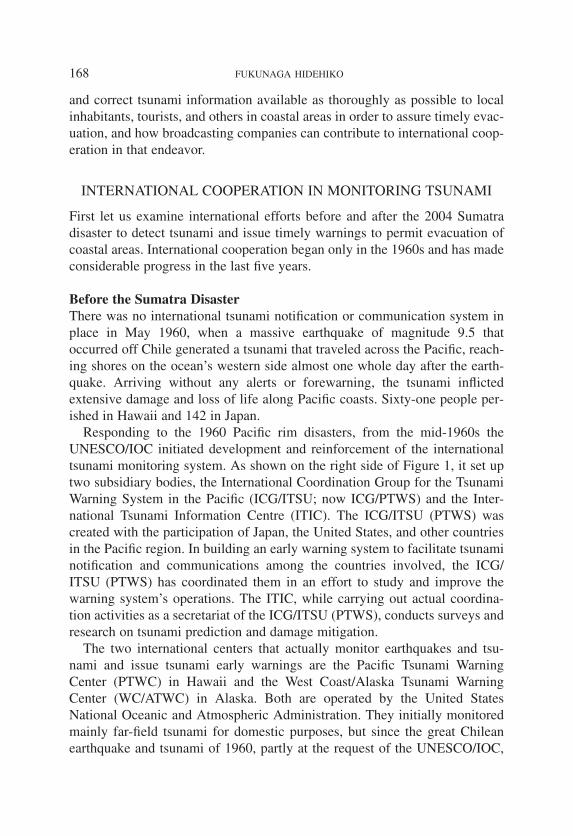
Responding to the 1960 Pacific rim disasters, from the mid-1960s theUNESCO/IOC initiated development and reinforcement of the internationaltsunami monitoring system. As shown on the right side of Figure 1, it set uptwo subsidiary bodies, the International Coordination Group for the TsunamiWarning System in the Pacific (ICG/ITSU; now ICG/PTWS) and the Inter-national Tsunami Information Centre (ITIC). The ICG/ITSU (PTWS) wascreated with the participation of Japan, the United States, and other countriesin the Pacific region. In building an early warning system to facilitate tsunaminotification and communications among the countries involved, the ICG/ITSU (PTWS) has coordinated them in an effort to study and improve thewarning system’s operations. The ITIC, while carrying out actual coordina-tion activities as a secretariat of the ICG/ITSU (PTWS), conducts surveys andresearch on tsunami prediction and damage mitigation.
The two international centers that actually monitor earthquakes and tsu-nami and issue tsunami early warnings are the Pacific Tsunami WarningCenter (PTWC) in Hawaii and the West Coast/Alaska Tsunami WarningCenter (WC/ATWC) in Alaska. Both are operated by the United StatesNational Oceanic and Atmospheric Administration. They initially monitoredmainly far-field tsunami for domestic purposes, but since the great Chileanearthquake and tsunami of 1960, partly at the request of the UNESCO/IOC,
168 FUKUNAGA HIDEHIKO
they began to issue early warnings to countries with coasts on the PacificOcean. The WC/ATWC is responsible for the coastal areas of Alaska, the U.S.mainland, and Canada, as well as Puerto Rico and the Virgin Islands. ThePTWC is responsible for Hawaii and the Pacific Rim region, excluding theU.S. mainland and Canada.
After the Sumatra DisasterInternational cooperation in the monitoring of tsunami was further strength-ened following the Sumatra earthquake and tsunami of 2004. In January 2005,immediately after the Sumatra disaster, the World Conference on DisasterReduction was convened in Kobe and a declaration adopted that stressed theimportance of early warning systems in the Indian Ocean. The June session ofthe UNESCO/IOC Assembly, held in Paris, issued a resolution establishingintergovernmental coordination groups (ICG) with a view to building earlywarning systems in the Indian Ocean, Northeast Atlantic, Mediterranean Sea,and Caribbean Sea. These groups are the ICG for the Indian Ocean TsunamiWarning and Mitigation System (ICG/IOTWS), the ICG for the TsunamiEarly Warning and Mitigation System in the North-eastern Atlantic, theMediterranean and Connected Seas (ICG/NEAMTWS), and the ICG for theTsunami and Other Coastal Hazards Warning System for the Caribbean andAdjacent Regions (ICG/CARIBE-EWS).
169INTERNATIONAL COOPERATION AND BROADCASTING OF TSUNAMI INFORMATION
Figure 1. The International Tsunami Monitoring System

To coordinate with these developments, the ICG/ITSU in the Pacific regionwas renamed the ICG for the Pacific Tsunami Warning and Mitigation System(ICG/PTWS). Also for the Pacific region, the Northwest Pacific TsunamiAdvisory Center (NWPTAC)—a new regional center in charge of monitoringearthquakes and tsunami and transmitting information—was inaugurated inMarch 2005 to supplement the information supplied by the U.S.-operatedPTWC in Hawaii. The new center is operated by the Japan MeteorologicalAgency, which provides tsunami information for Northwest Pacific nations.Thus a three-pronged warning system with the PTWC as its “headquarters”has emerged in the Pacific region.4 In March 2005, the JMA and the PTWCbegan supplying “tsunami watch information” to coastal nations of the IndianOcean as a provisional measure until the region’s early warning system iscompleted.
JAPANESE EARLY WARNINGS FOR OVERSEAS REGIONS
As mentioned above the Japan Meteorological Agency issues tsunami earlywarnings to coastal nations in the Northwest Pacific region and the IndianOcean. The following outlines the system currently in place and how it works.
Northwest PacificFigure 2 shows the coastal areas covered by the NWPTAC. The center sendstsunami information to 11 countries, including China, South Korea, Indonesia,the Philippines, and Vietnam.
When an earthquake of magnitude 6.5 or greater is detected, the NWPTACissues a tsunami advisory or warning, which includes the time the earthquakeoccurred, its epicenter and magnitude, tsunami potential, and, if a tsunami isexpected, its estimated height and arrival time at 65 designated coastal loca-tions. The NWPTAC aims to announce such advisories within 20 to 30 min-utes after an earthquake, and the information is utilized by each country indomestically issuing tsunami warnings or evacuation orders.
Tsunami forecasts are made through the following procedure: (1) Estimates are made of an earthquake’s hypocenter and magnitude based
on data such as the earthquake’s amplitude obtained via the Internetfrom 160 real-time seismic stations of the Incorporated ResearchInstitutions for Seismology (IRIS) global network.
4 ITIC website “PTWS Structure” treats PTWC as “operational headquarters” of the Pacifictsunami warning system. http://ioc3.unesco.org/itic/categories.php?category_no=153.
170 FUKUNAGA HIDEHIKO

171INTERNATIONAL COOPERATION AND BROADCASTING OF TSUNAMI INFORMATION
Figure 2. Coastal Areas Covered by NWPTAC
Figure 3. Tide Gauge Stations in the Pacific
(JMA source)
(JMA source)

(2) The estimated location and magnitude are cross-referenced against atsunami simulation database. Simulation figures are available in thedatabase for tsunami size in four increments calculated by depth ofearthquake focus and in six increments by magnitude of the tremor,depending on where around the Kuril trench, Japan trench, Marianatrench, or Philippine trench (which are susceptible to inter-plate earth-quakes) the focus of the earthquake is.
(3) The cross-references indicate initial tsunami wave forms, the heights ofthe waves up to five kilometers off designated coastal areas, and theirestimated arrival times.
(4) Tsunami wave heights increase as the waves approach a coast, and theheights (Hs) at the coast are calculated using Green’s formula, withwater depth (Ds) in the 65 coastal areas set at 1 meter:
“Ho” indicates tsunami height at a certain offshore point and “Do”water depth at the same point.
(5) Tide-gauge measurements obtained at 20 locations in the region (Figure3) are sent in real time via the World Meteorological Organization’s
HsDo
DsHo Do Ds Ho= 4 ⋅ = ⋅( / ) /1 4
172 FUKUNAGA HIDEHIKO
Figure 4. Regions Covered by Tsunami Watch Information for the Indian Ocean
(JMA source)

communication network to the JMA, which then transmits the measure-ments to individual countries as follow-up information. The informa-tion may be used to revise earlier tsunami forecasts.
Indian OceanFigure 4 shows the region covered by JMA tsunami watch information forIndian Ocean countries. The region consists of 26 countries, includingIndonesia, Thailand, Maldives, India, and South Africa. When an earthquakemeasuring at least magnitude 6.5 occurs, the JMA issues a tsunami advisory,conveying the time the earthquake occurred, the location of its epicenter, itsmagnitude, tsunami potential, and, if tsunami are expected, their estimatedarrival times at 43 designated offshore locations. It does not announce theheight of tsunami waves as it does for the Northwest Pacific region.
The JMA aims to announce such advisories within 20 to 30 minutes afteran earthquake, and the information is utilized by each country in domestical-ly issuing tsunami warnings and evacuation orders. Tsunami forecasts arebased on data from the IRIS seismic network and measurements from tide-gauge stations, as is the case with the Northwest Pacific, but no simulationdatabase information is available. Tsunami forecasts are issued through thefollowing procedure:
173INTERNATIONAL COOPERATION AND BROADCASTING OF TSUNAMI INFORMATION
Figure 5. Tide Gauge Stations in the Indian Ocean
(JMA source)

(1) A hypocenter and magnitude are estimated based on seismic datareceived from the IRIS network.
(2) From the estimated hypocenter and magnitude, fault parameters such asfault slip rates are estimated so as to forecast initial wave forms oftsunami.
(3) The times the tsunami will reach the 43 offshore locations are calculatedfrom U.S. National Geographic Data Center data on water depth atevery five minutes of latitude and longitude.
(4) The approximate velocity (v) at which a tsunami travels over the opensea can basically be obtained by the formula v =√G · Do. “G” stands forgravitational acceleration and “Do” depth of ocean water. The arrivaltime of a tsunami is calculated by determining its velocity by oceandepth. Estimated arrival times are announced in six phases from underone hour through more than 12 hours.
(5) Tide-gauge measurements obtained at 40 locations are sent in real timeto each country’s meteorological agency and may be used to revise ear-lier tsunami forecasts. (Figure 5)
NHK’S INTERNATIONAL BROADCASTING
The JMA has long reported domestically the occurrence of overseas earth-quakes of magnitude 7.0 or greater in the form of “distant earthquake infor-mation.” More recently, the JMA also began to add Northwest Pacific andIndian Ocean tsunami advisories to its distant earthquake information.
The possibility of tsunami occurrence overseas is divided into four levelsby magnitude. Under the Broadcast Law, NHK provides international broad-casting services both on television and radio as well as Internet informationservices for a world audience; it therefore promptly transmits tsunami infor-mation to other countries even when there is no possibility that the tsunamimight affect Japan. Of the four levels shown in Figure 6, the earthquakes cov-ered by NHK’s international broadcasting services are those with a magnitudeof at least 7.6 that may generate tsunami in either the Pacific or Indian oceans.5
Tsunami Broadcasting Overseas This section describes NHK’s policy (as of end of November 2008) inresponding to earthquake and tsunami information in its international broad-casting. NHK has two international television services: NHK World TV,
5 NHK provides similar international news flashes if the JMA transmits tsunami information tooverseas regions besides the Pacific and Indian oceans.
174 FUKUNAGA HIDEHIKO

which broadcasts English-language news and other programs targeted for for-eign audiences via communications satellite, and NHK World Premium,which transmits Japanese-language broadcasts for overseas Japanese nation-als and corporations via local cable television and satellite television stations.The first tsunami warning is provided in Japanese as a disaster announcementbanner appearing across the screen on both NHK World TV and NHK WorldPremium. Although normally targeted for foreign audiences, NHK World TVsends this flash banner in Japanese for Japanese residing overseas, followed asquickly as possible by an English “Breaking News” banner.
NHK World Radio Japan, a shortwave radio service, is divided into theGeneral Service, provided in Japanese and English, and the Regional Service,available in 18 languages including Japanese and English. It is on the GeneralService that the first tsunami news is read by an announcer in Japanese, fol-lowed by the reading of the Japanese news on both the General Service andthe Regional Service. During the hours when an English-language radioannouncer is in the studio, he or she reads out the English text as “BreakingNews.”
In March 2008, NHK partially revised its reporting manual so that in theevent of an earthquake of magnitude 7.9 or greater (Figure 6), its internation-al television service (NHK World Premium) would interrupt its regular pro-gram and have an announcer give the first report in Japanese from the studio.For the first radio report, the General Service broadcasts the report from thetelevision studio as is. In the case of an earthquake of magnitude 7.5–7.0,because the tsunami it generates is expected to occur only in the region nearits hypocenter and on a relatively small scale, as a general rule both the tele-vision and radio services include the report in scheduled news broadcastsrather than as news alerts.
175INTERNATIONAL COOPERATION AND BROADCASTING OF TSUNAMI INFORMATION
Figure 6. Effects of Tsunami Generated by Distant Earthquakes
Magnitude (M) Northwest Pacific Indian Ocean PTWC (criterion) tsunami info tsunami info (excl. Northwest Pacific)
M≧7.9 Possibility of Pacific- Possibility of Indian Possibility of Pacific-wide tsunami Ocean-wide tsunami wide tsunami
7.9>M≧7.6 Possibility of tsunami Possibility of tsunami Possibility of in the Pacific in the Indian Ocean tsunami in the Pacific
7.6>M≧7.1 Possibility of tsunami near hypocenter
M=7.0 Possibility of small tsunami near hypocenter but no damage expected
Table based on the JMA chart “Enchi jishin no jishin joho ni fukumeru tsunami no eikyo ni tsuite no fukabun no naiyo” [Additional Phrases about Tsunami Impacts to Be Included inDistant Earthquake Information]. The phrases are for earthquakes that occur in the ocean andwith a hypocenter less than 100 km deep.

Case Study: 2007 Southern Sumatra EarthquakeAs of the end of September 2008, the JMA had issued a total of 27 tsunamiadvisories for the Indian Ocean (after earthquakes of magnitude 6.5 or over).Of these, 10 were issued following an earthquake of magnitude 7.0 or greaterand were provided as “distant earthquake information.” Three advisories wereissued after an earthquake of magnitude 7.6 or greater, strong enough to becovered by news alerts on NHK international broadcasting channels. (SeeFigure 7.)
The largest-scale earthquake of those reported was the magnitude 8.2 earth-quake with an epicenter off southern Sumatra that occurred on September 12,2007. The tremor occurred within that part of the ocean where the Indo-Australian plate moves under the Eurasian plate. There the plate pushed itsway up, causing a reverse fault-type earthquake.
In Indonesia this strong quake left more than 25 people dead in Padang andother areas of Sumatra Island and more than 160 injured. The earthquakeoccurred at 8:10 P.M., Japan time; 26 minutes later, at 8:36 P.M., the JMAissued a tsunami advisory to coastal nations around the Indian Ocean, warn-ing of “the possibility of an ocean-wide and destructive tsunami.” One minuteafter that, the JMA issued a domestic distant earthquake information reportthat “no tsunami will hit Japan, but there is a possibility of tsunami arising inthe Indian Ocean.”
176 FUKUNAGA HIDEHIKO
Time of earthquake Time of Magni- Tsunami forecast Epicenter, tsunami observa-issuance tude tions, etc.
2005/7/25/0:42 A.M. 1:02 A.M. 7.3 Possibility of local tsunami Epicenter, Nicobar Islands
2006/2/23/7:19 A.M. 7:50 A.M. 7.2 No tsunami Epicenter, Mozambique(inland)
2006/7/17/5:19 P.M. 5:46 P.M. 7.2 Possibility of local tsunami Epicenter, S Java; tsunami observed (Rodrigues Island 40 cm, etc.)
2007/8/9/2:04 A.M. 2:32 A.M. 7.7 No tsunami Epicenter, Java (focus 310 km deep)
2007/9/12/8:10 P.M. 8:36 P.M. 8.2 Possibility of ocean- Epicenter, S Sumatra; tsunami wide tsunami observed (Padang 1.1 m, etc.)
2007/9/13/8:49 A.M. 9:09 A.M. 7.8 Possibility of regional tsunami Epicenter, S Sumatra
2007/9/13/0:35 P.M. 0:59 P.M. 7.1 Possibility of local tsunami Epicenter, S Sumatra
2007/10/25/6:03 A.M. 6:32 A.M. 7.0 Very small possibility of Epicenter, SW Sumatralocal tsunami
2008/2/20/5:09 P.M. 5:29 P.M. 7.2 Possibility of local tsunami Epicenter, N Sumatra
2008/2/25/5:37 P.M. 5:59 P.M. 7.1 Possibility of local tsunami Epicenter, S Sumatra
Compiled from JMA sources. Magnitude here is 7.0 or greater; revised data of initial estimates. All times are Japan Standard Time. Earthquakes are from the period between March 31, 2005 and September 31, 2008.
Figure 7. Tsunami Watch Information for the Indian Ocean

The estimated arrival time of the tsunami according to the tsunami advisoryissued at that time was within 1 hour for the Indian Ocean coasts of Sumatraand Java islands in Indonesia, within 1 to 3 hours for the entire coastline of SriLanka, within 3 to 6 hours for India’s coasts of the Arabian Sea and Bay ofBengal and for Thailand’s Malacca Strait coast, and within 6 to 9 hours for theentire coastline of Madagascar and Tanzania.
The first reporting by NHK international broadcasting services was anEnglish “Breaking News” banner shown by NHK World TV at 8:46 P.M., 36minutes after the earthquake and 10 minutes after the JMA’s issuance of thetsunami watch information. From 8:49 P.M., a Japanese flash news bannerappeared on both NHK World Premium and NHK World TV. The JMA issueda total of seven tsunami advisories for the Indian Ocean, including the actual-ly observed height of the tsunami, and NHK television services repeatedlybroadcast tsunami information not only in news banners but also in specialnewscasts. NHK World Radio Japan aired the first tsunami report in Japaneseon its General Service from 8:45 P.M., followed by continuous Japanese andEnglish news alerts on its General and Regional services.
After the earthquake, tsunami were observed widely around the IndianOcean (Figures 8 and 9). The initial wave was observed at Padang, located330 kilometers from the epicenter in the middle of the western coast ofSumatra, 45 minutes after the earthquake; at Cilacap on the island of Java 2
177INTERNATIONAL COOPERATION AND BROADCASTING OF TSUNAMI INFORMATION
Figure 8. Location of Tide Gauge Stations
KarachiQuarry Bay
Qui Nhon
Sittwe
Langkawi
BenoaCilacap*Epicenter
PadangSibolga
SabangTrincomalee
ColomboHanimaadoo
MaleGan
Pt. La Rue
Diego Garcia
Cocos Islands
RodriguesPort Louis
ZanzibarMombasa
Lamu
Djibouti
SalalahMasirah
(JMA source)

178 FUKUNAGA HIDEHIKO
Figure 9. Tsunami Observation Data and Arrival Times
Observation data First waves Maximum height
Gauge station (country) Arrival time Retreat, rise, height Time recorded Height
① Padang (Indonesia) 9/12/8:55 P.M. Retreat 0.4 m 9/12/11:27 P.M. 1.1 m
Cocos Islands (Australia) 9/12/9:28 P.M. Rise 0.1 m 9/12/9:39 P.M. 0.1 m
Cilacap (Indonesia) 9/12/10:13 P.M. Unknown 9/13/1:26 A.M. 0.2 m
Sibolga (Indonesia) 9/12/10:45 P.M. Unknown 9/13/5:20 A.M. 0.2 m
Colombo (Sri Lanka) 9/13/0:17 A.M. Rise 0.1 m 9/13/2:53 A.M. 0.3 m
Gan (Maldives) 9/13/0:17 A.M. Rise 0.2 m 9/13/0:38 A.M. 0.2 m
Diego Garcia (Chagos Archipelago, British Indian Ocean Territory)9/13/0:22 A.M. Rise 0.1 m 9/13/0:32 A.M. 0.1 m
Male (Maldives) 9/13/0:30 A.M. Rise 0.1 m 9/13/0:41 A.M. 0.1m
② Hanimaadoo (Maldives) 9/13/0:57 A.M. Rise 0.4 m 9/13/1:03 A.M. 0.4 m
③ Rodrigues (Mauritius) 9/13/2:13 A.M. Rise 0.3 m 9/13/2:39 A.M. 0.6 m
④ Pt. La Rue (Seychelles) 9/13/3:21 A.M. Unknown 9/13/5:06 A.M. 0.6 m
⑤ Salalah (Oman) 9/13/4:48 A.M. Retreat 0.3 m 9/13/5:48 A.M. 0.5 m
(Source: JMA documents.)All times are Japan Standard Time.
20:10
00:10
04:10 00:10
20:44
20:15
20:40
20:30
21:3020:35
20:50
22:02
23:0023:00
22:25
22:00
Epicenter
Estimated arrival time of tsunami
Time tsunami warnings were issued
Figure 10. Time of Issuance of Warnings by Country (IOTWS Survey)
Based on Overview of ICG/IOTWS and Status Report (Tony Elliott, Head, ICG/IOTWS Secretariat,IOC/UNESCO). All times are Japan Standard Time.

hours 3 minutes after the quake; and on the southwestern edge of the Bay ofBengal, Sri Lanka, 4 hours 7 minutes after the earthquake.
The tsunami information sent from Japan reached most of the coastal areas(except the region near the earthquake epicenter) before the tsunami hit. TheICG/IOTWS has surveyed, among other matters, the times tsunami warningswere issued by country.6 In Figure 10, times enclosed in rectangles on thecurved lines indicate the estimated tsunami arrival times.7 The figures in ovalsare the times tsunami warnings were issued in each country. Indonesia, locat-ed closest to the epicenter, issued a tsunami warning domestically 5 minutesafter the earthquake. Thailand and India did the same before they received theadvisory from the JMA. According to this survey, 57 percent of the govern-ment agencies in charge of disaster prevention in the 25 member states of theICG/IOTWS analyzed the earthquake on their own but only 38 percent usednumerical models.
Case Study: 2007 Kuril EarthquakeBy the end of September 2008, the JMA had issued a total of 45 tsunami advi-sories for the Northwest Pacific (following earthquakes each measuring atleast magnitude 6.5). Of these reports, 13 were issued after an earthquake ofminimum magnitude 7.0 and three after an earthquake of minimum magni-tude 7.6 (Figure 11).
The largest-scale earthquake among these was the magnitude-8.2 quakewith epicenter east of the Kuril Islands (Chishima Islands) that occurrred onJanuary 13, 2007. The quake was the result of destruction of the normal faultlines of the Pacific plate near the Kuril-Kamchatka trench.
Following the earthquake, 40-cm tsunami were observed off the coasts ofChichijima and Miyakejima islands, and the overseas tide-gauge stations atMidway Island, Hawaii, and elsewhere also confirmed tsunami. No one waskilled or missing, and no other serious damage resulted from the waves.
The Kuril earthquake occurred at 1:24 P.M., Japan time, and 12 minuteslater, at 1:36 P.M., the JMA issued a tsunami warning to the eastern Pacificcoast of Hokkaido and the coastal areas of the Sea of Okhotsk as well as atsunami advisory to the northern Sea of Japan coast of Hokkaido and the areafrom the central Pacific coast of Hokkaido all the way to Wakayama prefec-ture, as well as the Izu Islands. At the same time, the JMA sent overseas a
179INTERNATIONAL COOPERATION AND BROADCASTING OF TSUNAMI INFORMATION
6 Overview of ICG/IOTWS and Status Report (Tony Elliott, Head, ICG/IOTWS Secretariat,IOC/UNESCO).
7 The arrival times shown were estimated by the ICG/IOTWS and differ from those estimatedin the JMA tsunami watch information for the Indian Ocean.

tsunami advisory for the Northwest Pacific that stated “the possibility of anocean-wide destructive tsunami.”
NHK immediately broadcast a domestic tsunami warning/advisory. Thir-teen minutes after the JMA’s issuance of the advisory (warning), at 1:49 P.M.the first report for overseas listeners that a tsunami advisory had been issuedfor Japan in the wake of an earthquake off the Chishima Islands was aired byNHK World TV in an English “Breaking News” banner. Then, at 1:51 P.M.,which was 27 minutes after the earthquake and 15 minutes after the JMA’sissuance of the tsunami advisory, both NHK World TV and NHK WorldPremium aired a Northwest Pacific tsunami advisory as a news alert. NHKWorld Radio Japan aired the first tsunami report in Japanese on its General
180 FUKUNAGA HIDEHIKO
Time of earthquake Time of Magni- Tsunami forecast Epicenter, tsunami issuance tude observations, etc.
2005/9/9/4:27 P.M. 4:56 P.M. 7.3 Possibility of local tsunami Epicenter, Eastern Caroline Islands
2006/11/15/8:14 P.M. 8:30 P.M. 8.1 Possibility of ocean- Epicenter, Kuril Islands; wide tsunami tsunami observed
(Chichijima Island 50 cm, etc.)
2006/12/26/9:34 P.M. 9:42 P.M. 7.2 Possibility of local tsunami Epicenter, Taiwan
2007/1/13/1:24 P.M. 1:36 P.M. 8.2 Possibility of ocean- Epicenter, Eastern Kuril Islands; wide tsunami tsunami observed (Chichijima
Island 40 cm, etc.)
2007/1/21/8:28 P.M. 8:48 P.M. 7.2 Possibility of local tsunami Epicenter, Northern MoluccasSea
2007/4/2/5:40 A.M. 6:02 A.M. 8.1 Possibility of ocean- Epicenter, Solomon Islands; wide tsunami tsunami observed
(Honiara 20 cm, etc.)
2007/7/26/2:40 P.M. 2:57 P.M. 7.0 Very small possibility of Epicenter, Moluccas Sealocal tsunami
2007/9/2/10:05 A.M. 10:32 A.M. 7.3 Possibility of local tsunami Epicenter, Santa Cruz Islands
2007/9/28/10:39 P.M. 11:01 P.M. 7.4 No tsunami Epicenter, Mariana Islands (focus 276 km deep)
2007/9/30/11:09 A.M. 11:27 A.M. 7.1 Possibility of local tsunami Epicenter, Southern Mariana Islands
2007/10/31/12:30 P.M. 12:55 P.M. 7.0 No tsunami Epicenter, Mariana Islands (focus 235 km deep)
2008/6/14/8:43 A.M. 8:51 A.M. 7.2 No tsunami Iwate-Miyagi Inland Earthquake
2008/9/11/9:20 A.M. 9:24 A.M. 7.1 Very small possibility of Epicenter, off the coast oftsunami Tokachi; local tsunami observed
(Hanasaki 10 cm)
Based on JMA documents. Magnitude here is 7.0 or greater; revised data of initialestimates. The earthquakes are from the period between March 31, 2005 and September 31, 2008. All times are Japan Standard Time.
Figure 11. Tsunami Advisories for the Northwest Pacific

Service at 1:58 P.M., followed by Japanese and English news alerts on theGeneral and Regional services.
A total of four tsunami advisories for the Northwest Pacific were issued,and NHK international broadcasting services, television and radio, repeatedlyreported in scheduled news programs and special newscasts, in addition to thenews alert banners, about estimated tsunami arrival times, the height of thetsunami observed at Chichijima Island and elsewhere, and so forth. The esti-mated tsunami arrival times were 1 hour 10 minutes after the earthquake atPetropavlovsk-Kamchatsky on the eastern coast of Kamchatska peninsula,some 750 km from the epicenter; 1 hour 44 minutes at Ust-Kamchatsk, some1,200 km from the epicenter; around 4 hours 20 minutes at Guam and Saipanislands (Mariana Islands); and more than 5 and a half hours on the easterncoast of the Philippines. The tsunami information from Japan was received atmost areas—except the region near the earthquake epicenter—before the esti-mated arrival times of tsunami. The estimated tsunami heights were 50 cm atPetropavlovsk-Kamchatsky, 50 cm at Legazpi on the eastern coast of thePhilippines, and 1 m at Guam and Saipan islands.
Tsunami waves rise higher as they approach a coastline. Let us applyGreen’s formula to the case of Saipan. The offshore tsunami height (Ho) wasestimated at 26 cm, the offshore water depth (Do) is 225 m, and the coastalwater depth (Ds) is 1 m. We can compute the tsunami height (Hs) at the coastof Saipan by the following equation:
This results in an estimated tsunami height of 1 m. That means the offshoretsunami height increased by four times upon reaching the coast.
DISPERSED NETWORK OF TSUNAMI WATCH PROVIDERS
The ICG for Indian Ocean Tsunami Warning and Mitigation System has cho-sen a multiple-provider warning system for the Indian Ocean that consists of“regional tsunami watch providers” (RTWPs), instead of a single internation-al watch center.8 Several RTWPs monitor all the coasts of the Indian Ocean 24hours a day, 7 days a week and provide tsunami forecasts using database andsimulation values, as does the JMA for the Northwest Pacific. These providers
Hs = ×2251
0 264 .
8 Implementation Plan for Regional Tsunami Watch Providers (RTWP). See IntergovernmentalOceanographic Commission Technical Series 81. UNESCO, 2008.
181INTERNATIONAL COOPERATION AND BROADCASTING OF TSUNAMI INFORMATION
aim to issue tsunami warnings within 10 to 15 minutes of the occurrence of anearthquake of significant magnitude.
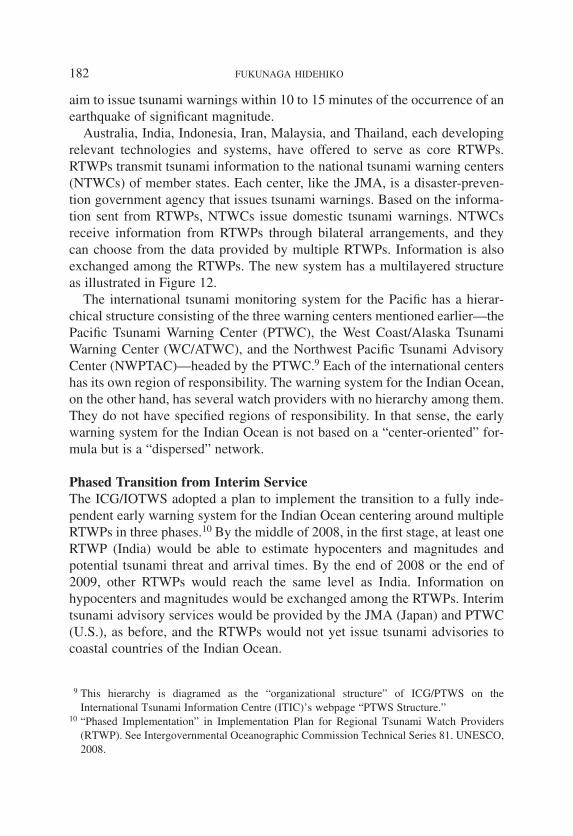
Australia, India, Indonesia, Iran, Malaysia, and Thailand, each developingrelevant technologies and systems, have offered to serve as core RTWPs.RTWPs transmit tsunami information to the national tsunami warning centers(NTWCs) of member states. Each center, like the JMA, is a disaster-preven-tion government agency that issues tsunami warnings. Based on the informa-tion sent from RTWPs, NTWCs issue domestic tsunami warnings. NTWCsreceive information from RTWPs through bilateral arrangements, and theycan choose from the data provided by multiple RTWPs. Information is alsoexchanged among the RTWPs. The new system has a multilayered structureas illustrated in Figure 12.
The international tsunami monitoring system for the Pacific has a hierar-chical structure consisting of the three warning centers mentioned earlier—thePacific Tsunami Warning Center (PTWC), the West Coast/Alaska TsunamiWarning Center (WC/ATWC), and the Northwest Pacific Tsunami AdvisoryCenter (NWPTAC)—headed by the PTWC.9 Each of the international centershas its own region of responsibility. The warning system for the Indian Ocean,on the other hand, has several watch providers with no hierarchy among them.They do not have specified regions of responsibility. In that sense, the earlywarning system for the Indian Ocean is not based on a “center-oriented” for-mula but is a “dispersed” network.
Phased Transition from Interim ServiceThe ICG/IOTWS adopted a plan to implement the transition to a fully inde-pendent early warning system for the Indian Ocean centering around multipleRTWPs in three phases.10 By the middle of 2008, in the first stage, at least oneRTWP (India) would be able to estimate hypocenters and magnitudes andpotential tsunami threat and arrival times. By the end of 2008 or the end of2009, other RTWPs would reach the same level as India. Information onhypocenters and magnitudes would be exchanged among the RTWPs. Interimtsunami advisory services would be provided by the JMA (Japan) and PTWC(U.S.), as before, and the RTWPs would not yet issue tsunami advisories tocoastal countries of the Indian Ocean.
9 This hierarchy is diagramed as the “organizational structure” of ICG/PTWS on theInternational Tsunami Information Centre (ITIC)’s webpage “PTWS Structure.”
10 “Phased Implementation” in Implementation Plan for Regional Tsunami Watch Providers(RTWP). See Intergovernmental Oceanographic Commission Technical Series 81. UNESCO,2008.
182 FUKUNAGA HIDEHIKO
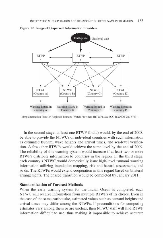
In the second stage, at least one RTWP (India) would, by the end of 2008,be able to provide the NTWCs of individual countries with such informationas estimated tsunami wave heights and arrival times, and sea-level verifica-tion. A few other RTWPs would achieve the same level by the end of 2009.The reliability of this warning system would increase if at least two or moreRTWPs distribute information to countries in the region. In the third stage,each country’s NTWC would domestically issue high-level tsunami warninginformation utilizing inundation mapping, risk-and-hazard assessments, andso on. The RTWPs would extend cooperation in this regard based on bilateralarrangements. The phased transition would be completed by January 2011.
Standardization of Forecast MethodsWhen the early warning system for the Indian Ocean is completed, eachNTWC will receive information from multiple RTWPs of its choice. Even inthe case of the same earthquake, estimated values such as tsunami heights andarrival times may differ among the RTWPs. If preconditions for computingestimates vary among them or are unclear, then NTWC staff will find RTWPinformation difficult to use, thus making it impossible to achieve accurate
183INTERNATIONAL COOPERATION AND BROADCASTING OF TSUNAMI INFORMATION
Figure 12. Image of Dispersed Information Providers
(Implementation Plan for Regional Tsunami Watch Providers (RTWP). See IOC-ICG/IOTWS-V/13)

comparison of estimated values. Estimation methods should be standardizedand made public.
“END-TO-END” SYSTEM AND BROADCASTING MEDIA
The goal of the UNESCO/IOC tsunami early warning system is to create fullyintegrated end-to-end information transmission.11 This system is designed toenable residents, workers, and tourists in coastal areas to evacuate ahead ofthe tsunami by making it possible for the tsunami information issued by thePTWC and NWPTAC in the Pacific and by RTWPs in the Indian Ocean to beprovided to them “promptly, correctly, and widely” via broadcasting mediaand disaster prevention authorities in the national and local governments ofindividual countries. Prompted by the widespread damage wreaked by the2004 Sumatra earthquake and tsunami, international cooperation is rapidlygrowing not only among RTWPs and other “upstream” sources of informationbut also among the “downstream” sources, namely, the broadcasting media,that serve as the point of contact with local inhabitants (audiences).
Technological Cooperation among Broadcasting MediaAt its October 2006 general assembly in Beijing, the Asia-PacificBroadcasting Union (ABU), an association of radio and television networks inthe Asia-Pacific region, adopted a declaration to implement an emergencywarning broadcast system for the region. The transmission division of theABU Technical Committee has launched a project for that purpose and begunto facilitate technological cooperation.
An emergency warning broadcast system developed by NHK Science andTechnical Research Laboratories has an established record of use when tsuna-mi warnings are issued within Japan, and many broadcasters that are ABUmembers have shown great interest in the system. A radio (analogue), alsodeveloped by NHK, capable of receiving emergency warning broadcasts wasput on display at the Broadcast Engineering Society’s Expo 2007, a broad-casting technology exhibition held by India’s state-run broadcaster inFebruary 2007. In addition, a warning reception system using “one-seg”handheld receivers that NHK was developing was introduced and attractedfavorable attention at the ABU Digital Broadcasting Symposiums held inKuala Lumpur, Malaysia in March 2007 and March 2008.
On the level of practical technological cooperation, engineers from radiobroadcasting stations in India and Nepal have engaged in research activities in
11 See Intergovernmental Oceanographic Commission Technical Series 71. UNESCO, 2006.
184 FUKUNAGA HIDEHIKO

the NHK Science and Technical Research Laboratories with a view to adopt-ing an emergency warning broadcasting system in their countries. TheRepublic of Korea and China each has been developing a system for provid-ing emergency warning broadcasts via digital mobile broadcasting services—the Digital Multimedia Broadcasting (DMB) and China Mobile MultimediaBroadcasting (CMMB), respectively. Reports outlining their systems werepresented at the ABU emergency warning broadcast system project. Thespread of broadcasting media and progress in adoption of digital technologyvary from country to country, and many countries might start out with rela-tively low-cost, analogue-type radio broadcasting for emergency warning.
Emergency Warning Signal Systems Emergency warning broadcasts are transmitted via broadcast waves using aspecial signal. TV, radio, and mobile terminals equipped with the warning-receiver function are activated automatically, conveying the tsunami and otheremergency information to listeners immediately.
The countries and broadcasters intending to adopt the emergency warningbroadcasting system must first determine in what cases they will transmitemergency warning broadcast signals. They will also need to determine thesignal codes so that receiving equipment can be set to read the signal, the cat-egory, and the target area. The code is a binary code of 1s and 0s.
In Japan there are two types of categories. Category I is for TokaiEarthquake Warning Alerts and requests for broadcasting made by the headsof local governments based on the Disaster Countermeasures Basic Act. In thecase of the Tokai Warning Alerts, receivers throughout the country will beautomatically activated, as will receivers only in relevant prefectures in thecase of emergency broadcasting requests. Category II concerns tsunami warn-ings, and in inland areas and elsewhere the receivers can be set so that signalreception is terminated by the user.
Figure 13 shows emergency warning broadcast “start” signals. In the caseof analogue signals, code “0” is modulated to 640 Hz and code 1 to 1024 Hz,using audible frequency ranges. This creates a sound that is heard by thehuman ear as a kind of high-pitched beeping. Figure 13 gives the “precedingcodes” listed as headers and the fixed codes indicating “country.” Applied toJapan, the fixed codes show that Japan as a whole is the target area. The com-binations of 1s and 0s are completely opposite for fixed code categories I andII, showing how the tsunami warnings (category II) are distinguished.
Area codes are divided by prefecture and are used when a request forbroadcast (category I) is made. There are two types of time codes—“day/month” and “year/time”—and this is for security purposes, preventing a
185INTERNATIONAL COOPERATION AND BROADCASTING OF TSUNAMI INFORMATION

recorded sound code from being illegally transmitted later. Whether to use thetime code or not is optional.
The start signal transmission is repeated four to ten times, with one blocbeing 1.5 seconds long at 96 bits. Study of such categories and codes hasbegun at India’s public radio station among others and a handbook for theiradoption has been produced by the ABU emergency warning broadcastingsystem project team. The International Telecommunication Union has issueda recommendation on standard code specifications for the purpose of signalinterference prevention and security maintenance.12 The ABU project alsoplans to present a guideline for implementation of emergency warning broad-casting and a set of rules for its operation and management. Among the chal-lenges the ABU cites are those of developing receivers, securing funds, andcollaborating with international organizations and government agencies inindividual countries.
CONCLUSION
Since the Sumatra tsunami disaster of 2004, rapid progress has been made inaugmenting and improving the international tsunami monitoring and warningsystem. Advances in communication and computer technologies have sped up
186 FUKUNAGA HIDEHIKO
12 Recommendation ITU-RBT/BO.1774.
Figure 13. Emergency Warning Broadcast “Start” Signal

187INTERNATIONAL COOPERATION AND BROADCASTING OF TSUNAMI INFORMATION
the transmission and analysis of earthquake and tsunami data. The global flowof tsunami information has changed greatly, and disaster prevention broad-casting and its technology have also spread internationally. Steady efforts totransmit tsunami information “quickly, correctly, and widely” are certainlynecessary, but the question is whether or not people, the end users of the infor-mation, will be able to correctly understand the information and take promptaction such as evacuation and whether or not they make sufficient prepara-tions in their daily lives for when a tsunami warning is issued.
Japan has engaged in broad-ranging international cooperation efforts,including the Japan International Cooperation Agency (JICA) disaster pre-vention education program for school children in Thailand. Commissioned byJICA, the NHK Communications Training Institute, too, has provided engi-neers and program directors of broadcasting organizations overseas, such asthose in Asia and Africa, with training in disaster information as conducted inJapan.
To achieve the aim of instituting an “end-to-end” international early warn-ing system, I believe it is necessary for the media, government agencies, andother relevant organizations to examine their approaches to information trans-mission and popular disaster information literacy, specifically the degree towhich people will take action upon receiving emergency information. Thebroadcasting media, which represent a crucial public interface as the down-stream transmitters of tsunami information, should convey the findings of sur-vey and research widely to the international society via global broadcasts,thereby contributing to the realization of the “end-to-end” warning system.
(Translated by Takechi Manabu)
web
タイプライターテキスト
NHK BROADCASTING STUDIES 2010 No.8