INTEGRATED NATURAL RESOURCES MANAGEMENT PLAN · final integrated natural resources management plan...
90
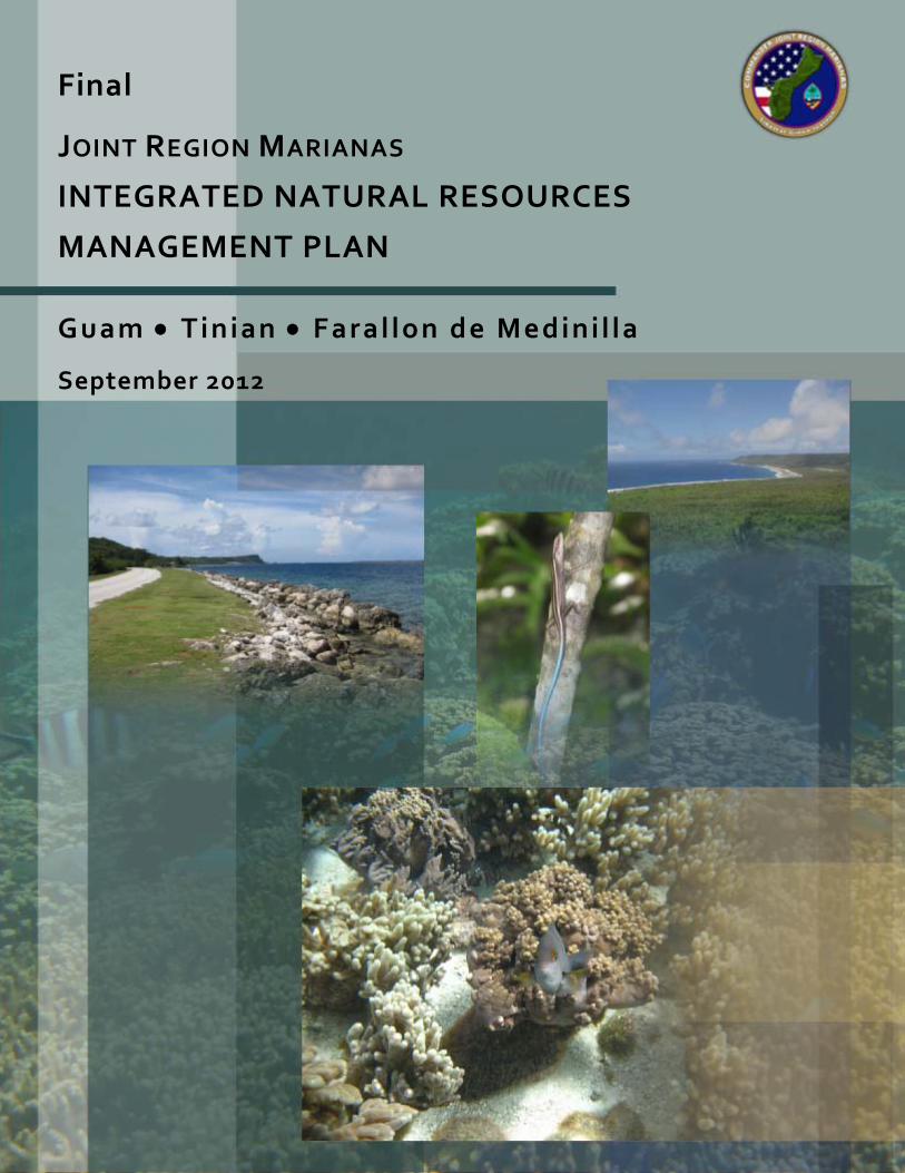
J OINT R EGION M ARIANAS INTEGRATED NATURAL RESOURCES MANAGEMENT PLAN Final Guam Tinian Farallon de Medinilla September 2012
-
Upload
hoangthuan -
Category
Documents
-
view
223 -
download
1
Transcript of INTEGRATED NATURAL RESOURCES MANAGEMENT PLAN · final integrated natural resources management plan...
JOINT REGION MARIANAS
INTEGRATED NATURAL RESOURCES
MANAGEMENT PLAN
Final
Guam Tinian Faral lon de Medini l la
September 2012

FINAL
INTEGRATED NATURAL RESOURCES
MANAGEMENT PLAN
JOINT REGION MARIANAS
GUAM, TINIAN, AND FARALLON DE MEDINILLA
Prepared for
JOINT REGIONS MARIANAS
Contract # SF1449-N40192-10-R-9915
SEPTEMBER 2012

ANNUAL REVIEW AND COORDINATION PAGE
This page is used to certify the annual review and coordination of the Integrated Natural Resources Management Plan (INRMP) for Joint Region Marianas, which includes Naval Base Guam, Andersen Air Force Base, Tinian, and Farallon de Medinilla.
By their signatures below, the certifying official acknowledges that the annual review and coordination of the INRMP has occurred for the specified year.
APPROVING OFFICIAL:
2012
NAME Commander Navy Installations Command Joint Region Marianas
Date
NAME Commanding Officer Mariana Naval Base Guam
Date
NAME Installation Commander Andersen Air Force Base
Date


ANNUAL REVIEW AND COORDINATION PAGE
This page is used to certify the annual review and coordination of the Integrated Natural Resources Management Plan (INRMP) for Joint Region Marianas, which includes Naval Base Guam, Andersen Air Force Base, Tinian, and Farallon de Medinilla.
By their signatures below, the certifying official acknowledges that the annual review and coordination of the INRMP has occurred for the specified year.
APPROVING OFFICIAL:
2013
NAME Commander Navy Installations Command Joint Region Marianas
Date
NAME Commanding Officer Naval Base Guam
Date
NAME Installation Commander Andersen Air Force Base
Date


ANNUAL REVIEW AND COORDINATION PAGE
This page is used to certify the annual review and coordination of the Integrated Natural Resources Management Plan (INRMP) for Joint Region Marianas, which includes Naval Base Guam, Andersen Air Force Base, Tinian, and Farallon de Medinilla.
By their signatures below, the certifying official acknowledges that the annual review and coordination of the INRMP has occurred for the specified year.
APPROVING OFFICIAL:
2014
NAME Commander Navy Installations Command Joint Region Marianas
Date
NAME Commanding Officer Naval Base Guam
Date
NAME Installation Commander Andersen Air Force Base
Date

ANNUAL REVIEW AND COORDINATION PAGE
This page is used to certify the annual review and coordination of the Integrated Natural Resources Management Plan (INRMP) for Joint Region Marianas, which includes Naval Base Guam, Andersen Air Force Base, Tinian, and Farallon de Medinilla.
By their signatures below, the certifying official acknowledges that the annual review and coordination of the INRMP has occurred for the specified year.
APPROVING OFFICIAL:
2015
NAME Commander Navy Installations Command Joint Region Marianas
Date
NAME Commanding Officer Naval Base Guam
Date
NAME Installation Commander Andersen Air Force Base
Date


ANNUAL REVIEW AND COORDINATION PAGE
This page is used to certify the annual review and coordination of the Integrated Natural Resources Management Plan (INRMP) for Joint Region Marianas, which includes Naval Base Guam, Andersen Air Force Base, Tinian, and Farallon de Medinilla.
By their signatures below, the certifying official acknowledges that the annual review and coordination of the INRMP has occurred for the specified year.
APPROVING OFFICIAL:
2016
NAME Commander Navy Installations Command Joint Region Marianas
Date
NAME Commanding Officer Naval Base Guam
Date
NAME Installation Commander Andersen Air Force Base
Date

JOINT REGION MARIANAS
NAVAL BASE GUAM, ANDERSEN AIR FORCE BASE, TINIAN, AND FARALLON DE MEDINILLA
The Integrated Natural Resources Management Plan (INRMP), dated June 2012, has been prepared in accordance with regulations, standards, and procedures of the Department of Defense (DOD); the U.S. Navy (DoN); and the Sikes Act Improvement Act (SAIA) as amended through 2010 (16 United States Code [U.S.C.] §670a et seq.) in cooperation with the U.S. Fish and Wildlife Service (USFWS), the National Oceanic and Atmospheric Administration (NOAA) National Marine Fisheries Service (NMFS), the Guam Department of Agriculture, Division of Aquatic and Wildlife Resources (GDAWR), and the Commonwealth of the Northern Marianas Department of Lands and Natural Resources (CNMI DLNR). The management of natural resources in this INRMP reflects the mutual agreement of all parties.
To the extent that availability of agency resources permit, the USFWS (Region 1), GDAWR, CMNI DLNR, and the Joint Region Marianas (JRM), by signature of their agency representative, do hereby agree to enter an agreement program for the conservation, protection, and management of natural resources present on JRM facilities including Navy Base Guam, Andersen Air Force Base, Tinian, and Farallon de Medinilla through implementation of this INRMP. The intention of this agreement is to develop functioning, sustainable ecological communities on JRM that integrate the interests and missions of the agencies charged with conservation, protection, and management of the natural heritage in the public interest with the military mission. The SAIA requires that INRMPs provide for no net loss in the capability of military installation lands to support the military mission of the installation.
The cooperating agencies agree to provide available mutual assistance under the authority of one or more of the following: the Fish and Wildlife Coordination Act (Title 16, U.S.C., Subchapter I, Section 661), the Economy Act (Title 31, U.S.C., Section 1535), and the SAIA. The SAIA requires preparation of INRMPs in cooperation with the USFWS, and the head of the appropriate state, territorial, or commonwealth fish and wildlife agency and, under 16 U.S.C. 670a(d)(2), priority shall be given to the entering into of contracts for the procurement of implementation and enforcement services with Federal, state, territorial, or commonwealth agencies having responsibility for conservation and management of fish or wildlife. The SAIA also states that DOD may enter into cooperative agreements with states (territories or commonwealth), local governments, nongovernmental organizations, and individuals, and into interagency agreements with the heads of other Federal departments and agencies (16 U.S.C. 670c). Further, funds appropriated to the DOD for a fiscal year may be obligated to cover the costs of goods and services provided to a cooperative agreement under the SAIA, or the Economy Act, during any 18-month period beginning in that fiscal year, without respect to whether the agreement crosses fiscal years. Any project funded by JRM in furtherance of the INRMP goals and objectives, shall be accompanied by a separate statement of work and budget mutually agreed to in advance by the participating parties. Section 101(b)(2) of the SAIA states that each INRMP “must be reviewed as to operation and effect by the parties thereto on a regular basis, but not less often than every 5 years.” The INRMP becomes effective upon the date subscribed by the last signatory hereunder. The initial term of the INRMP shall be 5 years, with coordination annually among party agencies. At the 5-year anniversary of the effective date of the INRMP, the party agencies shall perform a coordinated review to determine whether the INRMP requires significant revision, or minor updates. Thereafter, parties to this INRMP will coordinate annually, and, if the INRMP requires only minor updates, the INRMP shall remain in effect unless modified and amended by mutual agreement of the authorized representatives of the signatory agencies, or until terminated by written notice to the other parties, in whole or in part, by any of the parties signing this agreement.

By their signatures, or an enclosed letter of concurrence, all parties grant their concurrence and acceptance of this INRMP.
Approving Officials:
XXXX Commander Navy Installations Command Joint Region Marianas
Date
XXXXX Naval Base Guam
Date
XXXX Installation Commander Andersen Air Force Base
Date

INRMP ACCEPTANCE PAGE
Concurring agency:
U.S. Fish and Wildlife Service
Ms. Robyn Thorson Regional Director, Region 1 U.S. Fish and Wildlife Service
Date

INRMP ACCEPTANCE PAGE
Concurring agency:
National Oceanic and Atmospheric Administration National Marine Fisheries Service
Michael Tosatto Regional Administrator, Pacific Islands Regional Office National Oceanic and Atmospheric Administration National Marine Fisheries Service
Date

INRMP ACCEPTANCE PAGE
Concurring agency:
Guam Department of Agriculture Division of Aquatic and Wildlife Resources
Mrs. Mariquita F. Taitague Director Guam Department of Agriculture Division of Aquatic and Wildlife Resources
Date

INRMP ACCEPTANCE PAGE
Concurring agency:
Commonwealth of the Northern Mariana Islands Department of Lands and Natural Resources Division of Fish & Wildlife
Mr. Arnold Palacios Acting Secretary Commonwealth of the Northern Mariana Islands Department of Lands and Natural Resources Division of Fish & Wildlife
Date

Final INRMP Joint Region Marianas
Executive Summary September 2012
ES-1
1
Executive Summary 2
The purpose of this Integrated Natural Resources Management Plan (INRMP) is to chart a course for 3 natural resources management on Joint Region Marianas (JRM), which includes Navy and Air Force 4 holdings on Guam, and Navy-leased lands on Tinian and Farallon de Medinilla (FDM), which are part of 5 JRM under Commander Navy Installations Command (CNIC). It should be noted that while Air Force 6 holdings are included as part of JRM and natural resources management of Air Force lands are conducted 7 through Naval Facilities Engineering Command Marianas (NAVFACMAR), the U.S. Air Force continues 8 to manage the mission-essential activities conducted on Air Force holdings including managing flights 9 and runways. This INRMP was prepared in accordance with the Sikes Act Improvement Act (SAIA) as 10 amended through 2010, Department of Defense (DOD) Instruction 4715.03 Natural Resources 11 Conservation Program, Office of the Chief of Naval Operations Instruction (OPNAVINST) 5090.1D 12 Environmental Readiness Program Manual, and more recent Department of the Navy (DoN), DOD 13 SAIA, and INRMP guidance memoranda. The U.S. Fish and Wildlife Service (USFWS), National 14 Oceanic and Atmospheric Administration (NOAA) National Marine Fisheries Service (NMFS), and the 15 territorial fish and wildlife agencies, which for JRM is the Guam Department of Agricultural, Division of 16 Aquatic and Wildlife Resources (GDAWR) on Guam, and the Commonwealth of the Northern Marianas 17 Department of Lands and Natural Resources (CNMI DLNR) for Tinian, and FDM, have reviewed and 18 signed this INRMP, indicating their mutual agreement with the Commanding Officer regarding natural 19 resources management on the JRM sites. 20
This INRMP updates and combines the existing INRMPs for Naval Base Guam (NBG), Andersen Air 21 Force Base (AFB), and Tinian and FDM (USAF 2009, U.S. Navy 2009, and U.S. Navy 2010a), includes a 22 discussion of the natural resources on the JRM sites, and reviews natural resources activities undertaken 23 at JRM sites. This INRMP is organized according to the guidelines provided by the Office of the Under 24 Secretary of Defense in August 2006 and NAVFACMAR, and strives to fully integrate and coordinate the 25 natural resources program with other JRM plans and activities. This INRMP provides a description of 26 JRM sites (e.g., location, history, and mission), information about the surrounding physical and biotic 27 environment, and an assessment of the impacts on natural resources as a result of mission activities. 28 Furthermore, the INRMP recommends various management practices, in compliance with Federal, 29 territorial, commonwealth, and local standards, designed to mitigate impacts of the mission on local 30 ecosystems. In addition to terrestrial resources, JRM-managed submerged lands, which extend offshore 31 3 nautical miles from JRM holdings, are addressed in this INRMP. 32
It is the intent of this JRM INRMP to preclude designation of critical habitat, when appropriate, by 33 demonstrating special management of listed species. Special management or protection is a term that 34 originates in the definition of occupied critical habitat in Section 3 of the Endangered Species Act (ESA). 35 ESA does not require additional special management/critical habitat designation if adequate management 36 and protection is already in place. Adequate special management or protection is provided by a legally 37 operative INRMP that addresses the maintenance and improvement of the primary constituent elements 38 important to the species and manages the long-term conservation of the species. Three criteria are used to 39 determine if such special management and protection are provided: (1) there is a conservation benefit, 40 (2) there are assurances that the management plans will be implemented, and (3) there are assurances that 41 the conservation efforts will be effective. These three criteria will be met through the strategies presented 42 in this INRMP; therefore, designation of critical habitat is neither necessary nor legally required 43 (U.S. Navy 2006). 44
This INRMP is a guide for the management and stewardship of all natural resources present on the JRM 45 sites, while ensuring the successful accomplishment of the military mission. A multiple-use approach is 46
Final INRMP Joint Region Marianas
Executive Summary September 2012
ES-2
used to allow for the presence of mission-oriented activities while efficiently managing the natural 1 resources to conserve biodiversity and environmental quality. The INRMP presents practicable 2 alternatives and recommendations for the management and stewardship of natural resources and the 3 conservation and enhancement of existing ecosystems on the installation without any net loss in the 4 capability of JRM to support its military mission. Consequently, in some cases, the implementation of 5 certain recommendations might sacrifice the improvement of installation natural resources in deference to 6 the safety and efficiency of the mission. 7
The intent of this INRMP is to take an ecosystem approach to managing the natural resources present on 8 JRM. The interdisciplinary approach taken by this INRMP follows an ecosystem model, in which all 9 appropriate components are integrated by their function. Ecosystem management is emphasized because 10 it is recognized that the mission of the JRM is inextricably linked to local, regional, and global ecological 11 integrity. Sustaining ecosystem integrity is also the best way to protect biodiversity, ensure sustainable 12 use, and minimize the effort and cost of management. Native and natural communities, and the processes 13 that sustain them, are essential to sustaining system function and resilience over the long-term. 14
The overriding goal for the JRM INRMP is to provide for the restoration and enhancement of 15 habitats for native species including listed species over the long-term in manner that is consistent 16 with the military mission. 17
Key components to meeting this goal include the development of long-term ecosystem based 18 management plans for the overlay lands of the Guam National Wildlife Refuge on NBG, Andersen AFB, 19 and in JRM submerged lands in Sumay Cove and Apra Harbor which direct management of these areas 20 over the next 30 to 50 years. These plans will direct management on JRM through the development of 21 studies and projects that are based on, or have as primary components, goals and objectives that are 22 consistent with the overriding goal for the restoration and enhancement of habitats for native species 23 including listed species over the long-term. To ensure that JRM meets the overriding goal, coordination 24 between JRM site land managers and resource agencies should also continue over the long term. 25
Throughout the development of this INRMP, management concerns were identified in a number of 26 natural resources subject areas. Some of these natural resources concerns could have an adverse impact 27 on the JRM mission or future planning operations. One of the purposes of this INRMP is to identify 28 goals and objectives for the installation and to obtain workable and useful solutions for each concern. 29 Concerns involving natural resources constraints to planning and mission operations are discussed in 30 detail in Chapter 5 of this INRMP. Concerns are grouped into management sections according to their 31 relevance. Appendix C provides a list of projects to be implemented based on the concerns discussed in 32 Chapter 5. 33
This INRMP will serve as a planning tool for CNIC. As opportunities become available to seek funding 34 for environmental projects or as mitigation for future activities, this Plan will serve as a priority list to 35 better enable the Natural Resources department to practice effective ecosystem management. This Plan is 36 not meant as a definitive list of projects that will be automatically funded upon enactment. It provides 37 guidance to the resource managers on strategies to employ for the next 5 years. The Navy will implement 38 recommendations in the INRMP within the framework of regulatory compliance, national Navy mission 39 obligations, anti-terrorism and force protection limitations, and funding constraints. Any requirement for 40 the obligation of funds for projects in this INRMP shall be subject to the availability of funds 41 appropriated by Congress, and none of the proposed projects shall be interpreted to require obligation or 42 payment of funds in violation of any applicable Federal law, including the Anti-Deficiency Act, 31 43 United States Code (U.S.C.) § 341, et seq. 44
Final INRMP Joint Region Marianas
Table of Contents September 2012
ii
FINAL INTEGRATED NATURAL RESOURCES MANAGEMENT PLAN JOINT REGION MARIANAS
GUAM, TINIAN, AND FARALLON DE MEDINILLA
TABLE OF CONTENTS
ANNUAL REVIEW AND COORDINATION PAGE
SIGNATURE PAGE
INRMP ACCEPTANCE PAGE
EXECUTIVE SUMMARY .................................................................................................................. ES-1
1. OVERVIEW ................................................................................................................................... 1-1
1.1 PURPOSE AND SCOPE OF PLAN ............................................................................................... 1-1 1.2 GOALS AND OBJECTIVES ........................................................................................................ 1-3 1.3 AUTHORITY ............................................................................................................................ 1-4 1.4 STEWARDSHIP AND COMPLIANCE .......................................................................................... 1-5 1.5 INRMP REVIEW AND REVISION PROCESS .............................................................................. 1-6 1.6 RESPONSIBLE PARTIES FOR NATURAL RESOURCES MANAGEMENT ON JOINT REGION
MARIANAS LANDS .................................................................................................................. 1-7 1.6.1 Joint Region Marianas ............................................................................................... 1-7
1.6.1.1 Naval Base Guam .................................................................................. 1-9 1.6.1.2 Andersen Air Force Base ....................................................................... 1-9
1.6.2 Signatory Agencies ................................................................................................... 1-9 1.6.2.1 U.S. Fish and Wildlife Service .............................................................. 1-9 1.6.2.2 National Oceanic and Atmospheric Administration ............................ 1-10 1.6.2.3 Guam Department of Agriculture, Division of Aquatic and Wildlife
Resources ............................................................................................. 1-10 1.6.2.4 Commonwealth of the Northern Mariana Department of Lands and
Natural Resources, Division of Fish and Wildlife ............................... 1-11 1.7 INTEGRATION WITH OTHER JOINT REGION MARIANAS SITE PLANS AND PROGRAMS ......... 1-11
1.7.1 U.S. Navy ................................................................................................................ 1-11 1.7.2 U.S. Air Force ......................................................................................................... 1-12 1.7.3 Guam Comprehensive Wildlife Conservation Strategy .......................................... 1-12
2. LOCATION, MISSION, AND LAND USE ................................................................................. 2-1
2.1 LOCATION ............................................................................................................................... 2-1 2.2 ABBREVIATED HISTORY OF GUAM ......................................................................................... 2-1 2.3 REGIONAL LAND USE ............................................................................................................. 2-1 2.4 MILITARY MISSION ................................................................................................................ 2-4
2.4.1 Naval Base Guam ...................................................................................................... 2-4 2.4.2 Andersen Air Force Base .......................................................................................... 2-4
2.5 OPERATIONS AND ACTIVITIES AND THEIR EFFECTS ON THE NATURAL ENVIRONMENT ........ 2-4 2.5.1 Naval Base Guam Main Base .................................................................................... 2-4
2.5.1.1 Operations .............................................................................................. 2-4 2.5.1.2 Environmental Effects ........................................................................... 2-6
2.5.2 Naval Munitions Site ................................................................................................. 2-9 2.5.2.1 Operations .............................................................................................. 2-9 2.5.2.2 Environmental Effects ......................................................................... 2-12
2.5.3 Naval Base Guam Telecommunications Site .......................................................... 2-12 2.5.3.1 Operations ............................................................................................ 2-12
Final INRMP Joint Region Marianas
Table of Contents September 2012
iii
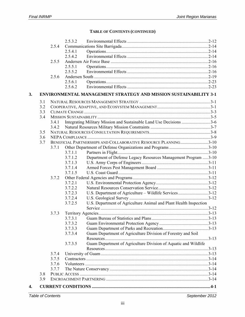
TABLE OF CONTENTS (CONTINUED)
2.5.3.2 Environmental Effects ......................................................................... 2-12 2.5.4 Communications Site Barrigada .............................................................................. 2-14
2.5.4.1 Operations ............................................................................................ 2-14 2.5.4.2 Environmental Effects ......................................................................... 2-14
2.5.5 Andersen Air Force Base ........................................................................................ 2-16 2.5.5.1 Operations ............................................................................................ 2-16 2.5.5.2 Environmental Effects ......................................................................... 2-16
2.5.6 Andersen South ....................................................................................................... 2-19 2.5.6.1 Operations ............................................................................................ 2-23 2.5.6.2 Environmental Effects ......................................................................... 2-23
3. ENVIRONMENTAL MANAGEMENT STRATEGY AND MISSION SUSTAINABILITY 3-1
3.1 NATURAL RESOURCES MANAGEMENT STRATEGY ................................................................ 3-1 3.2 COOPERATIVE, ADAPTIVE, AND ECOSYSTEM MANAGEMENT ................................................ 3-1 3.3 CLIMATE CHANGE .................................................................................................................. 3-3 3.4 MISSION SUSTAINABILITY ...................................................................................................... 3-5
3.4.1 Integrating Military Mission and Sustainable Land Use Decisions .......................... 3-6 3.4.2 Natural Resources Military Mission Constraints ...................................................... 3-7
3.5 NATURAL RESOURCES CONSULTATION REQUIREMENTS ....................................................... 3-8 3.6 NEPA COMPLIANCE ............................................................................................................... 3-9 3.7 BENEFICIAL PARTNERSHIPS AND COLLABORATIVE RESOURCE PLANNING ......................... 3-10
3.7.1 Other Department of Defense Organizations and Programs ................................... 3-10 3.7.1.1 Partners in Flight .................................................................................. 3-10 3.7.1.2 Department of Defense Legacy Resources Management Program ..... 3-10 3.7.1.3 U.S. Army Corps of Engineers ............................................................ 3-11 3.7.1.4 Armed Forces Pest Management Board .............................................. 3-11 3.7.1.5 U.S. Coast Guard ................................................................................. 3-11
3.7.2 Other Federal Agencies and Programs .................................................................... 3-12 3.7.2.1 U.S. Environmental Protection Agency ............................................... 3-12 3.7.2.2 Natural Resources Conservation Service ............................................. 3-12 3.7.2.3 U.S. Department of Agriculture – Wildlife Services ........................... 3-12 3.7.2.4 U.S. Geological Survey ....................................................................... 3-12 3.7.2.5 U.S. Department of Agriculture Animal and Plant Health Inspection
Service ................................................................................................. 3-12 3.7.3 Territory Agencies ................................................................................................... 3-13
3.7.3.1 Guam Bureau of Statistics and Plans ................................................... 3-13 3.7.3.2 Guam Environmental Protection Agency ............................................ 3-13 3.7.3.3 Guam Department of Parks and Recreation ......................................... 3-13 3.7.3.4 Guam Department of Agriculture Division of Forestry and Soil
Resources ............................................................................................. 3-13 3.7.3.5 Guam Department of Agriculture Division of Aquatic and Wildlife
Resources ............................................................................................. 3-13 3.7.4 University of Guam ................................................................................................. 3-13 3.7.5 Contractors .............................................................................................................. 3-14 3.7.6 Volunteers ............................................................................................................... 3-14 3.7.7 The Nature Conservancy ......................................................................................... 3-14
3.8 PUBLIC ACCESS .................................................................................................................... 3-14 3.9 ENCROACHMENT PARTNERING ............................................................................................ 3-14
4. CURRENT CONDITIONS ........................................................................................................... 4-1

Final INRMP Joint Region Marianas
Table of Contents September 2012
iv
TABLE OF CONTENTS (CONTINUED)
4.1 GUAM ..................................................................................................................................... 4-1 4.1.1 General Physical Environment .................................................................................. 4-1
4.1.1.1 Climate ................................................................................................... 4-1 4.1.1.2 Geology and Topography ...................................................................... 4-1 4.1.1.3 Seismology ............................................................................................ 4-5 4.1.1.4 Soils ....................................................................................................... 4-5 4.1.1.5 Hydrology .............................................................................................. 4-5 4.1.1.6 Wildland Fire ......................................................................................... 4-7
4.1.2 General Biotic Environment ...................................................................................... 4-8 4.1.2.1 Terrestrial Ecosystems ........................................................................... 4-8 4.1.2.2 Freshwater Ecosystems ........................................................................ 4-14 4.1.2.3 Estuarine Ecosystems .......................................................................... 4-16 4.1.2.4 Submerged Lands ................................................................................ 4-17 4.1.2.5 Coral Reef Ecosystems ........................................................................ 4-21 4.1.2.6 Protected Species ................................................................................. 4-27 4.1.2.7 Other Species of Interest ...................................................................... 4-48 4.1.2.8 Invasive Species ................................................................................... 4-51
4.2 NAVAL BASE GUAM MAIN BASE ......................................................................................... 4-58 4.2.1 General Physical Environment ................................................................................ 4-58
4.2.1.1 Climate ................................................................................................. 4-58 4.2.1.2 Geology and Topography .................................................................... 4-58 4.2.1.3 Seismology .......................................................................................... 4-58 4.2.1.4 Soils ..................................................................................................... 4-58 4.2.1.5 Hydrology ............................................................................................ 4-60
4.2.2 General Biotic Environment .................................................................................... 4-60 4.2.2.1 Terrestrial Ecosystems ......................................................................... 4-60 4.2.2.2 Freshwater Ecosystems ........................................................................ 4-65 4.2.2.3 Estuarine Ecosystems .......................................................................... 4-66 4.2.2.4 Submerged Lands ................................................................................ 4-70 4.2.2.5 Protected Species ................................................................................. 4-73 4.2.2.6 Invasive Species ................................................................................... 4-75
4.3 NAVAL MUNITIONS SITE ...................................................................................................... 4-76 4.3.1 General Physical Environment ................................................................................ 4-76
4.3.1.1 Climate ................................................................................................. 4-76 4.3.1.2 Geology and Topography .................................................................... 4-76 4.3.1.3 Seismology .......................................................................................... 4-76 4.3.1.4 Soils ..................................................................................................... 4-76 4.3.1.5 Hydrology ............................................................................................ 4-76
4.3.2 General Biotic Environment .................................................................................... 4-79 4.3.2.1 Terrestrial Ecosystems ......................................................................... 4-79 4.3.2.2 Freshwater Ecosystems ........................................................................ 4-81 4.3.2.3 Estuarine Ecosystems .......................................................................... 4-83 4.3.2.4 Submerged Lands ................................................................................ 4-83 4.3.2.5 Protected Species ................................................................................. 4-83 4.3.2.6 Invasive Species ................................................................................... 4-85
4.4 NAVAL BASE GUAM TELECOMMUNICATIONS SITE ............................................................. 4-87 4.4.1 General Physical Environment ................................................................................ 4-87
4.4.1.1 Climate ................................................................................................. 4-87 4.4.1.2 Geology and Topography .................................................................... 4-87
Final INRMP Joint Region Marianas
Table of Contents September 2012
v
TABLE OF CONTENTS (CONTINUED)
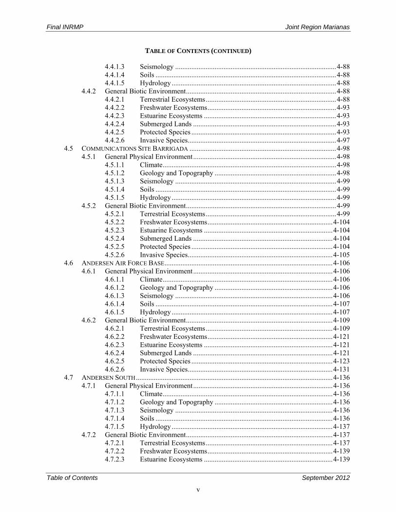
4.4.1.3 Seismology .......................................................................................... 4-88 4.4.1.4 Soils ..................................................................................................... 4-88 4.4.1.5 Hydrology ............................................................................................ 4-88
4.4.2 General Biotic Environment .................................................................................... 4-88 4.4.2.1 Terrestrial Ecosystems ......................................................................... 4-88 4.4.2.2 Freshwater Ecosystems ........................................................................ 4-93 4.4.2.3 Estuarine Ecosystems .......................................................................... 4-93 4.4.2.4 Submerged Lands ................................................................................ 4-93 4.4.2.5 Protected Species ................................................................................. 4-93 4.4.2.6 Invasive Species ................................................................................... 4-97
4.5 COMMUNICATIONS SITE BARRIGADA .................................................................................. 4-98 4.5.1 General Physical Environment ................................................................................ 4-98
4.5.1.1 Climate ................................................................................................. 4-98 4.5.1.2 Geology and Topography .................................................................... 4-98 4.5.1.3 Seismology .......................................................................................... 4-99 4.5.1.4 Soils ..................................................................................................... 4-99 4.5.1.5 Hydrology ............................................................................................ 4-99
4.5.2 General Biotic Environment .................................................................................... 4-99 4.5.2.1 Terrestrial Ecosystems ......................................................................... 4-99 4.5.2.2 Freshwater Ecosystems ...................................................................... 4-104 4.5.2.3 Estuarine Ecosystems ........................................................................ 4-104 4.5.2.4 Submerged Lands .............................................................................. 4-104 4.5.2.5 Protected Species ............................................................................... 4-104 4.5.2.6 Invasive Species ................................................................................. 4-105
4.6 ANDERSEN AIR FORCE BASE .............................................................................................. 4-106 4.6.1 General Physical Environment .............................................................................. 4-106
4.6.1.1 Climate ............................................................................................... 4-106 4.6.1.2 Geology and Topography .................................................................. 4-106 4.6.1.3 Seismology ........................................................................................ 4-106 4.6.1.4 Soils ................................................................................................... 4-107 4.6.1.5 Hydrology .......................................................................................... 4-107
4.6.2 General Biotic Environment .................................................................................. 4-109 4.6.2.1 Terrestrial Ecosystems ....................................................................... 4-109 4.6.2.2 Freshwater Ecosystems ...................................................................... 4-121 4.6.2.3 Estuarine Ecosystems ........................................................................ 4-121 4.6.2.4 Submerged Lands .............................................................................. 4-121 4.6.2.5 Protected Species ............................................................................... 4-123 4.6.2.6 Invasive Species ................................................................................. 4-131
4.7 ANDERSEN SOUTH .............................................................................................................. 4-136 4.7.1 General Physical Environment .............................................................................. 4-136
4.7.1.1 Climate ............................................................................................... 4-136 4.7.1.2 Geology and Topography .................................................................. 4-136 4.7.1.3 Seismology ........................................................................................ 4-136 4.7.1.4 Soils ................................................................................................... 4-136 4.7.1.5 Hydrology .......................................................................................... 4-137
4.7.2 General Biotic Environment .................................................................................. 4-137 4.7.2.1 Terrestrial Ecosystems ....................................................................... 4-137 4.7.2.2 Freshwater Ecosystems ...................................................................... 4-139 4.7.2.3 Estuarine Ecosystems ........................................................................ 4-139
Final INRMP Joint Region Marianas
Table of Contents September 2012
vi
TABLE OF CONTENTS (CONTINUED)
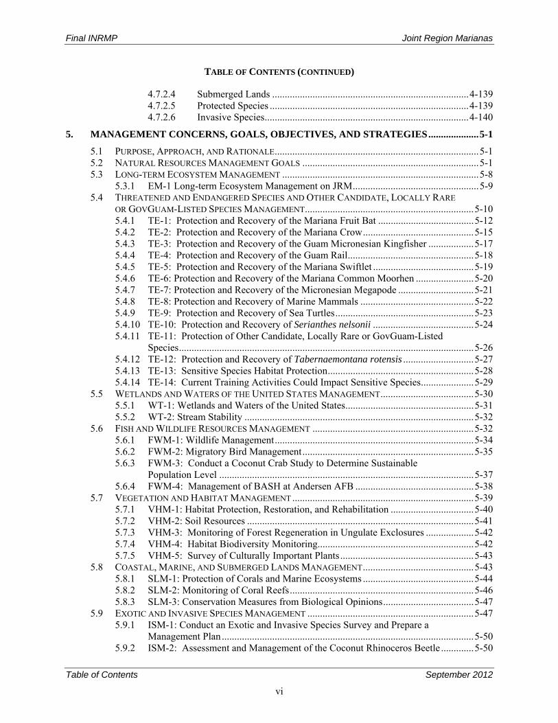
4.7.2.4 Submerged Lands .............................................................................. 4-139 4.7.2.5 Protected Species ............................................................................... 4-139 4.7.2.6 Invasive Species ................................................................................. 4-140
5. MANAGEMENT CONCERNS, GOALS, OBJECTIVES, AND STRATEGIES .................... 5-1
5.1 PURPOSE, APPROACH, AND RATIONALE ................................................................................. 5-1 5.2 NATURAL RESOURCES MANAGEMENT GOALS ...................................................................... 5-1 5.3 LONG-TERM ECOSYSTEM MANAGEMENT .............................................................................. 5-8
5.3.1 EM-1 Long-term Ecosystem Management on JRM .................................................. 5-9 5.4 THREATENED AND ENDANGERED SPECIES AND OTHER CANDIDATE, LOCALLY RARE
OR GOVGUAM-LISTED SPECIES MANAGEMENT ................................................................... 5-10 5.4.1 TE-1: Protection and Recovery of the Mariana Fruit Bat ...................................... 5-12 5.4.2 TE-2: Protection and Recovery of the Mariana Crow ............................................ 5-15 5.4.3 TE-3: Protection and Recovery of the Guam Micronesian Kingfisher .................. 5-17 5.4.4 TE-4: Protection and Recovery of the Guam Rail .................................................. 5-18 5.4.5 TE-5: Protection and Recovery of the Mariana Swiftlet ........................................ 5-19 5.4.6 TE-6: Protection and Recovery of the Mariana Common Moorhen ....................... 5-20 5.4.7 TE-7: Protection and Recovery of the Micronesian Megapode .............................. 5-21 5.4.8 TE-8: Protection and Recovery of Marine Mammals ............................................. 5-22 5.4.9 TE-9: Protection and Recovery of Sea Turtles ....................................................... 5-23 5.4.10 TE-10: Protection and Recovery of Serianthes nelsonii ........................................ 5-24 5.4.11 TE-11: Protection of Other Candidate, Locally Rare or GovGuam-Listed
Species ..................................................................................................................... 5-26 5.4.12 TE-12: Protection and Recovery of Tabernaemontana rotensis ............................ 5-27 5.4.13 TE-13: Sensitive Species Habitat Protection .......................................................... 5-28 5.4.14 TE-14: Current Training Activities Could Impact Sensitive Species ..................... 5-29
5.5 WETLANDS AND WATERS OF THE UNITED STATES MANAGEMENT ..................................... 5-30 5.5.1 WT-1: Wetlands and Waters of the United States ................................................... 5-31 5.5.2 WT-2: Stream Stability ........................................................................................... 5-32
5.6 FISH AND WILDLIFE RESOURCES MANAGEMENT ................................................................ 5-32 5.6.1 FWM-1: Wildlife Management ............................................................................... 5-34 5.6.2 FWM-2: Migratory Bird Management .................................................................... 5-35 5.6.3 FWM-3: Conduct a Coconut Crab Study to Determine Sustainable
Population Level ..................................................................................................... 5-37 5.6.4 FWM-4: Management of BASH at Andersen AFB ............................................... 5-38
5.7 VEGETATION AND HABITAT MANAGEMENT ........................................................................ 5-39 5.7.1 VHM-1: Habitat Protection, Restoration, and Rehabilitation ................................. 5-40 5.7.2 VHM-2: Soil Resources .......................................................................................... 5-41 5.7.3 VHM-3: Monitoring of Forest Regeneration in Ungulate Exclosures ................... 5-42 5.7.4 VHM-4: Habitat Biodiversity Monitoring.............................................................. 5-42 5.7.5 VHM-5: Survey of Culturally Important Plants ..................................................... 5-43
5.8 COASTAL, MARINE, AND SUBMERGED LANDS MANAGEMENT ............................................ 5-43 5.8.1 SLM-1: Protection of Corals and Marine Ecosystems ............................................ 5-44 5.8.2 SLM-2: Monitoring of Coral Reefs ......................................................................... 5-46 5.8.3 SLM-3: Conservation Measures from Biological Opinions .................................... 5-47
5.9 EXOTIC AND INVASIVE SPECIES MANAGEMENT .................................................................. 5-47 5.9.1 ISM-1: Conduct an Exotic and Invasive Species Survey and Prepare a
Management Plan .................................................................................................... 5-50 5.9.2 ISM-2: Assessment and Management of the Coconut Rhinoceros Beetle ............. 5-50
Final INRMP Joint Region Marianas
Table of Contents September 2012
vii
TABLE OF CONTENTS (CONTINUED)
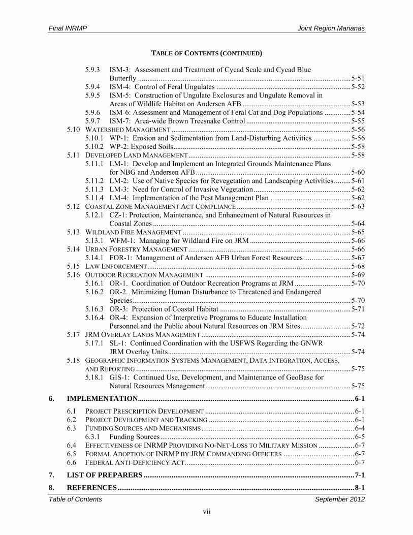
5.9.3 ISM-3: Assessment and Treatment of Cycad Scale and Cycad Blue Butterfly .................................................................................................................. 5-51
5.9.4 ISM-4: Control of Feral Ungulates ........................................................................ 5-52 5.9.5 ISM-5: Construction of Ungulate Exclosures and Ungulate Removal in
Areas of Wildlife Habitat on Andersen AFB .......................................................... 5-53 5.9.6 ISM-6: Assessment and Management of Feral Cat and Dog Populations .............. 5-54 5.9.7 ISM-7: Area-wide Brown Treesnake Control ........................................................ 5-55
5.10 WATERSHED MANAGEMENT ................................................................................................ 5-56 5.10.1 WP-1: Erosion and Sedimentation from Land-Disturbing Activities .................... 5-56 5.10.2 WP-2: Exposed Soils ............................................................................................... 5-58
5.11 DEVELOPED LAND MANAGEMENT ....................................................................................... 5-58 5.11.1 LM-1: Develop and Implement an Integrated Grounds Maintenance Plans
for NBG and Andersen AFB ................................................................................... 5-60 5.11.2 LM-2: Use of Native Species for Revegetation and Landscaping Activities ......... 5-61 5.11.3 LM-3: Need for Control of Invasive Vegetation .................................................... 5-62 5.11.4 LM-4: Implementation of the Pest Management Plan ........................................... 5-62
5.12 COASTAL ZONE MANAGEMENT ACT COMPLIANCE ............................................................. 5-63 5.12.1 CZ-1: Protection, Maintenance, and Enhancement of Natural Resources in
Coastal Zones .......................................................................................................... 5-64 5.13 WILDLAND FIRE MANAGEMENT .......................................................................................... 5-65
5.13.1 WFM-1: Managing for Wildland Fire on JRM ...................................................... 5-66 5.14 URBAN FORESTRY MANAGEMENT ....................................................................................... 5-66
5.14.1 FOR-1: Management of Andersen AFB Urban Forest Resources ......................... 5-67 5.15 LAW ENFORCEMENT ............................................................................................................. 5-68 5.16 OUTDOOR RECREATION MANAGEMENT .............................................................................. 5-69
5.16.1 OR-1. Coordination of Outdoor Recreation Programs at JRM .............................. 5-70 5.16.2 OR-2. Minimizing Human Disturbance to Threatened and Endangered
Species ..................................................................................................................... 5-70 5.16.3 OR-3: Protection of Coastal Habitat ...................................................................... 5-71 5.16.4 OR-4: Expansion of Interpretive Programs to Educate Installation
Personnel and the Public about Natural Resources on JRM Sites ........................... 5-72 5.17 JRM OVERLAY LANDS MANAGEMENT ................................................................................ 5-74
5.17.1 SL-1: Continued Coordination with the USFWS Regarding the GNWR JRM Overlay Units .................................................................................................. 5-74
5.18 GEOGRAPHIC INFORMATION SYSTEMS MANAGEMENT, DATA INTEGRATION, ACCESS, AND REPORTING ................................................................................................................... 5-75 5.18.1 GIS-1: Continued Use, Development, and Maintenance of GeoBase for
Natural Resources Management .............................................................................. 5-75
6. IMPLEMENTATION .................................................................................................................... 6-1
6.1 PROJECT PRESCRIPTION DEVELOPMENT ................................................................................ 6-1 6.2 PROJECT DEVELOPMENT AND TRACKING .............................................................................. 6-1 6.3 FUNDING SOURCES AND MECHANISMS .................................................................................. 6-4
6.3.1 Funding Sources ........................................................................................................ 6-5 6.4 EFFECTIVENESS OF INRMP PROVIDING NO-NET-LOSS TO MILITARY MISSION ................... 6-7 6.5 FORMAL ADOPTION OF INRMP BY JRM COMMANDING OFFICERS ...................................... 6-7 6.6 FEDERAL ANTI-DEFICIENCY ACT ........................................................................................... 6-7
7. LIST OF PREPARERS ................................................................................................................. 7-1
8. REFERENCES ............................................................................................................................... 8-1
Final INRMP Joint Region Marianas
Table of Contents September 2012
viii
APPENDICES
A ACRONYMS AND ABBREVIATIONS (Acronyms for Tinian and FDM Included in Appendix D)
B RELEVANT ENVIRONMENTAL LAWS, REGULATIONS, POLICIES, GUIDANCE, INSTRUCTIONS, AND ORDERS (Relevant Laws, Regulations, Policies, Guidance, Instructions and Orders for Tinian and FDM Included in Appendix D)
C INRMP PROJECTS, SCHEDULES AND IMPLEMENTATION TABLE
D UPDATE OF THE INTEGRATED NATURAL RESOURCES MANAGEMENT PLANS FOR U.S. NAVY
LEASED LANDS ON TINIAN AND FARALLON DE MEDINILLA
E BENEFITS FOR ENDANGERED SPECIES
F MIGRATORY BIRD MANAGEMENT
G INFORMATION REGARDING SPECIES PRESENCE AND ASSOCIATIONS AT JOINT REGION
MARIANAS
G1 BIRDS
G2 MAMMALS
G3 FISH, MARINE INVERTEBRATES, AND MARINE PLANT SPECIES
G4 REPTILES AND AMPHIBIANS
G5 INVERTEBRATES
G6 PLANTS
H NAVY NATURAL RESOURCES METRICS INFORMATION
I INRMP DOCUMENTATION, CORRESPONDENCE, AND COMPLETED COMMENT RESPONSE
MATRICES
J INFORMATION SUPPORTING FISH AND WILDLIFE/THREATENED AND ENDANGERED SPECIES
MANAGEMENT
K INFORMATION SUPPORTING WETLANDS AND FLOODPLAINS MANAGEMENT
L INFORMATION SUPPORTING WATERSHED MANAGEMENT AND PROTECTION
M INFORMATION SUPPORTING COASTAL ZONE MANAGEMENT
N INFORMATION SUPPORTING SUBMERGED LANDS MANAGEMENT
O INFORMATION SUPPORTING INVASIVE SPECIES MANAGEMENT
P INFORMATION SUPPORTING GROUNDS MAINTENANCE AND LAND MANAGEMENT
Q INFORMATION SUPPORTING OUTDOOR RECREATION AND PUBLIC ACCESS
R INFORMATION SUPPORTING GEOGRAPHIC INFORMATION SYSTEMS
S ENVIRONMENTAL ASSESSMENT ADDRESSING THE INTEGRATED NATURAL RESOURCES
MANAGEMENT PLAN FOR JOINT REGION MARIANAS GUAM, TINIAN, AND FARALLON DE
MEDINILLA
Final INRMP Joint Region Marianas
Table of Contents September 2012
ix
FIGURES
2-1a. Location of Mariana Islands Archipelago ........................................................................................ 2-2 2-1b. Location of Joint Region Marianas Sites on Guam .......................................................................... 2-3 2-2. Location of Naval Base Guam Main Base ....................................................................................... 2-5 2-3. Explosive Safety Quantity Distance Arcs for NBG ......................................................................... 2-7 2-4. Guam National Wildlife Refuge Areas on Naval Base Guam Main Base and Naval
Munitions Site .................................................................................................................................. 2-8 2-5. Location of the Naval Munitions Site ............................................................................................ 2-10 2-6. Explosive Safety Quantity Distance Arcs for Naval Munitions Site ............................................. 2-11 2-7. Location of Naval Base Guam Telecommunications Site .............................................................. 2-13 2-8. Location of Communications Site Barrigada ................................................................................. 2-15 2-9a. Location of Andersen AFB ............................................................................................................ 2-17 2-9b. Location of Andersen AFB Operations .......................................................................................... 2-18 2-10. ESQD Arcs on Andersen AFB ....................................................................................................... 2-20 2-11. Guam National Wildlife Refuge Areas on Andersen Air Force Base ............................................ 2-21 2-12. Location of Andersen South ........................................................................................................... 2-22 4-1. Geology of Guam ............................................................................................................................. 4-2 4-2. Topography of Guam ....................................................................................................................... 4-3 4-3. JRM Submerged Lands .................................................................................................................. 4-25 4-4. Soils on Naval Base Guam Main Base ........................................................................................... 4-59 4-5. Surface Water and Wetlands on NBG Main Base ......................................................................... 4-61 4-6. Vegetation Communities on NBG Main Base ............................................................................... 4-62 4-7. Wetlands on NBG Main Base ........................................................................................................ 4-67 4-8. Photograph of Marsh Vegetation in Wetland 1 of San Luis Ponds ................................................ 4-68 4-9. JRM Managed Submerged Lands at NBG Main Base ................................................................... 4-71 4-10. Soils on Naval Munitions Site ........................................................................................................ 4-77 4-11. Surface Water and Wetlands on Naval Munitions Site .................................................................. 4-78 4-12. Vegetation Communities on Naval Munitions Site ........................................................................ 4-80 4-13. Mariana Swiftlet Population Data from Mahlac Cave within Naval Munitions Site from FY
1986–FY 2012. (Data provided by A. Brooke, NAVFACMAR) ................................................. 4-84 4-14. Guam tree snail populations observed during surveys conducted in 2009 in NMS (Smith et
al. 2008) ......................................................................................................................................... 4-86 4-15. Soils on Naval Base Guam Telecommunications Site ................................................................... 4-89 4-16. Vegetation Communities on Naval Base Guam Telecommunications Site ................................... 4-90 4-17. JRM-Managed Submerged Lands at Naval Base Guam Telecommunications Site ...................... 4-94 4-18. Partulid Tree Snail Populations on Naval Base Guam Telecommunications Site ......................... 4-96 4-19. Soils on Communications Site Barrigada ..................................................................................... 4-100 4-20. Vegetation Communities on Communications Site Barrigada ..................................................... 4-101 4-21. Wetlands on Communications Site Barrigada ............................................................................. 4-103 4-22. Soils on Andersen AFB ................................................................................................................ 4-108 4-23. Correlation of Vegetation Community Locations Identified by Fosberg (1960) and the 2008
Survey .......................................................................................................................................... 4-113 4-24. Strangler Fig on Andersen AFB ................................................................................................... 4-114 4-25. Neisosperma oppositifolia on Andersen AFB .............................................................................. 4-114 4-26. Macaranga thompsonii on Andersen AFB .................................................................................. 4-115 4-27. Cycas micronesica on Andersen AFB ......................................................................................... 4-115 4-28. Mixed Limestone Forest-Toe Slope/Primary on Andersen AFB ................................................. 4-116 4-29. Screwpine (Pandanus tectorius) on Andersen AFB .................................................................... 4-117 4-30. Secondary Limestone Forest on Andersen AFB .......................................................................... 4-117 4-31. Coastal Strand Vegetation on Andersen AFB .............................................................................. 4-118 4-32. JRM Managed Submerged Lands at Andersen AFB ................................................................... 4-122 4-33. Range of the Micronesian Starling on Andersen AFB and Adjacent Areas ................................ 4-124
Final INRMP Joint Region Marianas
Table of Contents September 2012
x
4-34. Historic Mariana Fruit Bat Roost Locations on Andersen AFB .................................................. 4-126 4-35. Mariana Fruit Bat Colony at Pati Point. Fruit Bats Pictured Roosting in Mammea odorata
Trees ............................................................................................................................................. 4-127 4-36. Mariana Fruit Bat Counts at the Pati Point Colony from FY 1984 to FY 2012 ........................... 4-127 4-37. Observations of Mariana Fruit Bats on Andersen AFB (SWCA 2012). ...................................... 4-128 4-38. Green Sea Turtle Nesting Areas on Andersen AFB ..................................................................... 4-130 4-39. Locations of Fire Trees on Andersen Air Force Base .................................................................. 4-132 4-40. Former Coconut Plantation on Andersen AFB ............................................................................ 4-133 4-41. Chromolaena on Andersen AFB .................................................................................................. 4-134 5-1. Threatened and Endangered Species Coordination Chart .............................................................. 5-13
TABLES
1-1. Facilities Managed under Joint Region Marianas ............................................................................ 1-2 4-1. Number of Fires and Acres Burned by Year for Guam and NBG, 1991 through 2002 ................... 4-8 4-2. Native Freshwater Aquatic Plants of Guam ................................................................................... 4-15 4-3. Occurrence of Proposed Coral Species at Naval Base Guam, Farallon De Medinilla and
Tinian Military Lease Areas .......................................................................................................... 4-24 4-4. Federal, GovGuam, and CNMI Listed Threatened and Endangered Species ................................ 4-28 4-5. JRM Managed Submerged Lands and Dual Designations ............................................................. 4-72 4-6. Vegetation Community Types and Characteristic Species Found on Andersen Air Force
Base .............................................................................................................................................. 4-110 4-7. Total Area for Each Vegetation Community Type on Andersen Air Force Base ........................ 4-111 4-8. Vegetation Community Correlation between Fosberg (1960) and the 2008 Survey on
Andersen Air Force Base ............................................................................................................. 4-112 4-9. Vegetation Community Correlation between Donnegan et al. (2004) and the 2008 Survey
on Andersen Air Force Base ........................................................................................................ 4-112 4-10. Green Sea Turtle Nesting on Andersen AFB from 2005 to 2010 (Data provided by Shawn
Wusstig, GDAWR) ...................................................................................................................... 4-129 4-11. Native Tree Species on Andersen South ...................................................................................... 4-138 5-1. Summary of INRMP Goals .............................................................................................................. 5-2 5-2. INRMP Subject Area Abbreviations ................................................................................................ 5-5 5-3. Compensatory Mitigations Associated with Biological Opinions that are Currently
Programmed or in Progress .............................................................................................................. 5-6 5-4. Summary of Long-term Ecosystem Management Goals ................................................................. 5-9 5-5. Summary of Threatened and Endangered Species Management Goals ......................................... 5-12 5-6. Summary of Wetlands and Waters of the United States Management Goals ................................ 5-30 5-7. Summary of Wildlife and Fisheries Management Goals ............................................................... 5-34 5-8. Summary of Vegetation and Habitat Management Goals .............................................................. 5-40 5-9. Summary of Coastal, Marine, and Submerged Lands Management Goals .................................... 5-44 5-10. Summary of Exotic and Invasive Species Management Goals ...................................................... 5-49 5-11. Summary of Watershed Management Goals .................................................................................. 5-56 5-12. Summary of Land Management Goals ........................................................................................... 5-60 5-13. Summary of Coastal Zone Management Act Compliance Goals ................................................... 5-64 5-14. Summary of Wildland Fire Management Goals ............................................................................ 5-66 5-15. Summary of Urban and Commercial Forestry Management Goals ............................................... 5-67 5-16. Summary of Natural Resources Law Enforcement Goals .............................................................. 5-68 5-17. Summary of Outdoor Recreation/Public Access Management Goals ............................................ 5-69 5-18. Summary of Surrounding Lands Management Goal ...................................................................... 5-74 5-19. Summary of GIS Management Goals ............................................................................................ 5-75 6-1. Funding Classes for Recurring and Non-Recurring Conservation Requirements and Navy
Environmental Readiness Levels ..................................................................................................... 6-2

Final INRMP Joint Region Marianas
Overview September 2012
1-1
1. Overview 1
An Integrated Natural Resources Management Plan (INRMP) is a long-term planning document designed 2 to guide a Department of Defense (DOD) natural resources manager in the management of natural 3 resources to support an installation’s mission while protecting and enhancing installation resources for 4 multiple use, sustainable yield, and biological integrity. 5
This INRMP complies with the Sikes Act Improvement Act Amendment of 1997 (SAIA), as amended 6 through 2010 (16 United States Code [U.S.C.] 670a et seq.), which requires the preparation, 7 implementation, update, and review of an INRMP for each military installation in the United States and 8 its territories with significant natural resources. This plan is prepared in cooperation with the U.S. Fish 9 and Wildlife Service (USFWS), the National Oceanic and Atmospheric Administration (NOAA) National 10 Marine Fisheries Service (NMFS), and the territorial and commonwealth fish and wildlife agencies, 11 which for Guam is the Guam Department of Agriculture, Division of Aquatic and Wildlife Resources 12 (GDAWR), and the Commonwealth of the Northern Marianas Department of Lands and Natural 13 Resources (CNMI DLNR) for Tinian, and FDM. 14
This INRMP provides for the conservation and rehabilitation of natural resources and the sustainable 15 multipurpose use of resources subject to safety requirements and military security. It provides for no net 16 loss in the capability of installation lands to support the military mission and other activities as considered 17 appropriate to the military. At the same time, this document provides for management of wildlife and 18 land, wildlife enhancement and modification, establishment of natural resources management objectives 19 and time frames, sustained use by the public of natural resources to the extent that such use is not 20 inconsistent with other needs, and public access where appropriate, as well as the enforcement of natural 21 resource laws and regulations. 22
This INRMP is designed to support the military mission, manage natural resources, and to ensure 23 compliance with related environmental laws and regulations. The plan ensures the maintenance of quality 24 training land, thereby supporting DOD in accomplishing its critical military mission. 25
For more detail on the purpose of the JRM INRMP, management authorities, and legislative drivers for 26 management, please review the following sections. 27
All figures in this INRMP were compiled by HDR, except if noted, using data believed to be accurate at 28 the time of publication. However, a degree of error is inherent in all figures. The figures are distributed 29 “AS-IS,” without warranties of any kind, expressed, or implied, including, but not limited to, warranties 30 of suitability to a particular purpose or use. No attempt has been made in either the design or production 31 of the figures to define the limits or jurisdiction of any Federal, territorial, commonwealth, or local 32 government. The figures are intended for use only at the published scale. Detailed on-the-ground surveys 33 and historical analyses of sites might differ from the figures. 34
1.1 Purpose and Scope of Plan 35
The purpose of this INRMP is to chart a course for natural resources management on Joint Region 36 Marianas (JRM), which includes U.S. Navy and U.S. Air Force holdings on Guam, and Navy-leased 37 lands on Tinian and Farallon de Medinilla (FDM), which are part of JRM under Commander Navy 38 Installations Command (CNIC). It should be noted that while Air Force holdings are included as part of 39 JRM and natural resources management of Air Force lands are conducted through Naval Facilities 40 Engineering Command Marianas (NAVFACMAR), the U.S. Air Force continues to manage the mission 41 essential activities conducted on Air Force holdings including managing flights and runways. This 42
Final INRMP Joint Region Marianas
Overview September 2012
1-2
INRMP is consistent with the SAIA, guidance and regulations provided in DOD Instruction 4715.03 1 (Natural Resources Conservation Program), Office of the Chief of Naval Operations Instruction 2 (OPNAVINST) 5090.1D (Navy Environmental and Natural Resources Program Manual), and more 3 recent Department of the Navy (DoN), DOD SAIA, and INRMP guidance memoranda. These guidance 4 documents collectively require a plan and management approach that integrates mission support, 5 ecosystem- or landscape-level management, and environmental compliance and stewardship. 6
This INRMP was developed based on a thorough review of the existing INRMPs for Naval Base Guam 7 (NBG), Andersen Air Force Base (AFB), and Tinian and FDM; review of new data pertaining to these 8 sites; and detailed discussions with NAVFACMAR personnel, and various INRMP stakeholders. The 9 plan strives to integrate INRMP activities with other installation plans and activities, and provides explicit 10 goals and objectives to which natural resources strategies and projects will contribute. The projects and 11 strategies contained in this plan include a combination of ongoing natural resources management 12 activities from previous years and new projects and activities identified as priorities during the review 13 process. 14
This INRMP updates and combines the existing INRMPs for NBG, Andersen AFB, and Tinian and FDM 15 (USAF 2009, U.S. Navy 2009, and U.S. Navy 2010a), includes a discussion of the natural resources on 16 the JRM sites, and reviews natural resources activities undertaken at JRM sites. This INRMP is 17 organized according to the guidelines provided by the Office of the Under Secretary of Defense in August 18 2006 and NAVFACMAR. The scope of this INRMP includes all lands managed under JRM (see 19 Table 1-1). 20
Table 1-1. Facilities Managed under Joint Region Marianas 21
Facility Name Previous Name Total
Acreage Submerged
Lands Ecological
Reserve Area Refuge Overlay
NBG Main Base1 Waterfront Annex 6,205 33,181 163 12,2374
Naval Munitions Site Ordnance Annex 8,800
NBG TS2 Communications Annex Finegayan
3,000 19,550 252
Communications Site Barrigada
Communications Annex Barrigada
1,800 ---
Andersen AFB3 16,021 26,529 10,300
Andersen AFB South MARBO Annex 1,922 ---
Tinian 15,400
Farallon de Medinilla 182
Total Managed Acreage 53,330 79,260 415 22,537 Notes: 1. Orote Peninsula Ecological Reserve Area 2. Haputo Ecological Resource Area 3. Guam National Wildlife Refuge 4. Includes the acreage of the Guam National Wildlife Refuge on both NBG Main Base and Naval Munitions Site
This INRMP provides a description of JRM sites (e.g., location, history, and mission), information about 22 the surrounding physical and biotic environment, and an assessment of the impacts on natural resources as 23 a result of mission activities. Furthermore, the INRMP recommends various management practices, in 24
Final INRMP Joint Region Marianas
Overview September 2012
1-3
compliance with Federal, territory, commonwealth, and local standards, designed to mitigate impacts of 1 the mission on local ecosystems. In addition to terrestrial resources, JRM-managed submerged lands, 2 which extend offshore 3 nautical miles from JRM holdings, are addressed in this INRMP. 3
It is the intent of this JRM INRMP to preclude designation of critical habitat, when appropriate, by 4 demonstrating special management of listed species. Special management or protection is a term that 5 originates in the definition of occupied critical habitat in Section 3 of the Endangered Species Act (ESA). 6 ESA does not require additional special management/critical habitat designation if adequate management 7 and protection is already in place. Adequate special management or protection is provided by a legally 8 operative INRMP that addresses the maintenance and improvement of the primary constituent elements 9 important to the species and manages the long-term conservation of the species. Three criteria are used to 10 determine if such special management and protection are provided: (1) there is a conservation benefit, 11 (2) there are assurances that the management plans will be implemented, and (3) there are assurances that 12 the conservation efforts will be effective. These three criteria will be met through the projects and 13 strategies presented in this INRMP; therefore, designation of critical habitat is neither necessary nor 14 legally required (U.S. Navy 2006). 15
1.2 Goals and Objectives 16
According to the SAIA, the vision of an installation INRMP is to ensure the sustainability of all 17 ecosystems within the installation, and to ensure a no-net-loss of the capability of the installations to 18 support the military mission (U.S. Navy 2006). To meet the intent of the SAIA, the DOD adopted 19 ecosystem management as the basis for future management of DOD lands and waters through applying 20 the principles of adaptive management and through collaborating with parties both inside and outside the 21 fence (DOD 2011). In addition, the DoN developed guidance for developing and implementing INRMPs 22 at Navy installations in 1998, and revised the guidance in 2006 (U.S. Navy 2006). This guidance was 23 revised in 2006 based on lessons learned from the first round of INRMPs developed by the Navy, which 24 included the following (U.S. Navy 2006): 25
1. Increasing the ties between natural resources management and military readiness. 26 2. Establishing a consistent funding policy and project review process. 27 3. Improving the efficiency of INRMP review and coordination. 28 4. Increasing the effective implementation of INRMPs. 29 5. Expanding opportunities for involvement with all INRMP stakeholders. 30
The 2006 guidance also stressed the need for clear INRMP goals and objectives to guide natural resources 31 management on an installation while ensuring a no net loss to the mission. The guidance defines goals as 32 “broad guiding principles for the [installation natural resources] program” and objectives as “measurable 33 targets for achieving the goals” (U.S. Navy 2006). In addition, the guidance states that the INRMP will 34 provide parameters to determine “the effectiveness” of the natural resources program outlined in the 35 INRMP through ensuring that the plan includes “quantifiable, scientifically valid parameters that will 36 demonstrate achievement of objectives,” or INRMP projects (U.S. Navy 2006). 37
The overriding goal for the JRM INRMP is to provide for the restoration and enhancement of 38 habitats for native species including listed species over the long-term in manner that is consistent 39 with the military mission. 40
Key components to meeting this goal include the development of long-term ecosystem based 41 management plans for the overlay units on NBG, Andersen AFB, and in JRM submerged lands in Sumay 42 Cove and Apra Harbor to direct management of these areas over the next 30 to 50 years. These plans will 43 direct management on JRM through the development of studies and projects that are based on, or have as 44
Final INRMP Joint Region Marianas
Overview September 2012
1-4
primary components, goals and objectives that are consistent with the overriding goal for the restoration 1 and enhancement of habitats for native species including listed species over the long-term. 2
To achieve this goal, resource-specific goals, objectives, and strategies have been developed to guide 3 natural resources management on JRM sites. Each of the management strategies described in this INRMP 4 should be monitored so that changes can be made as environmental conditions change. INRMP goals 5 may be revised over time to reflect changing missions and environmental conditions. Any future changes 6 in mission, training activity, or technology should be analyzed to assess their impacts on natural 7 resources. As new installation plans and DoN guidance and regulations are developed, they will be 8 integrated into this INRMP. The INRMP will be reviewed, assessed, and modified as needed annually, 9 and updated every 5 years. 10
Throughout the development of this INRMP, management concerns were identified in a number of 11 natural resources subject areas. Some of these natural resources concerns could have an adverse impact 12 on the mission or future planning operations of JRM sites. One of the purposes of this INRMP is to 13 identify goals and objectives for JRM and to obtain workable and useful solutions for each concern. The 14 concerns involving natural resources constraints to planning and mission operations are discussed in 15 detail in Chapter 5. Natural resources concerns are grouped into management sections according to their 16 relevance. Appendix C provides a list of projects to be implemented based on the concerns and strategies 17 discussed in Chapter 5. While projects from the 2010 Update of the Integrated Natural Resources 18 Management Plan for Tinian and FDM for Navy-leased lands at Tinian and FDM are included in both 19 Chapter 5 and Appendix C, the INRMP and included information pertaining to location, mission, 20 operations, and existing conditions for these lands is included as Appendix D. 21
This INRMP will serve as a planning tool for CNIC. As opportunities become available to seek funding 22 for environmental projects or as mitigation for future activities, this Plan will serve as a priority list to 23 better enable the Natural Resources department to practice effective ecosystem management. This Plan is 24 not meant as a definitive list of projects that will be automatically funded upon enactment. It provides 25 guidance to the resource managers on strategies to employ for the next 5 years. The Navy will implement 26 recommendations in the INRMP within the framework of regulatory compliance, national Navy mission 27 obligations, anti-terrorism and force protection limitations, and funding constraints. Any requirement for 28 the obligation of funds for projects in this INRMP shall be subject to the availability of funds 29 appropriated by Congress, and none of the proposed projects shall be interpreted to require obligation or 30 payment of funds in violation of any applicable Federal law, including the Anti-Deficiency Act, 31 31 U.S.C. § 341, et seq. 32
1.3 Authority 33
This INRMP was developed in concert with guidance and regulations provided in the SAIA, DOD 34 Instruction 4715.03 (Environmental Conservation Program (2011), OPNAVINST 5090.1C CH-1, 35 Environmental Readiness Program Manual (DoN 2011), and associated DoN and DOD SAIA and 36 INRMP guidance memoranda. These guidance documents collectively require a plan and management 37 approach that integrates mission support, multipurpose use, ecosystem- or landscape-level management, 38 and environmental compliance and stewardship. The SAIA is one of the primary drivers behind the JRM 39 natural resources management program and INRMP. According to the SAIA, the purposes of a military 40 conservation program are conservation and rehabilitation of natural resources, sustainable multipurpose 41 use of those resources, and public access to military lands, subject to safety requirements and military 42 security. Moreover, the conservation program must be consistent with the mission-essential use of the 43 JRM and its lands. The SAIA requires the preparation of an INRMP to facilitate the conservation 44 program. The INRMP shall be prepared in cooperation with the USFWS, NMFS, and the territory and 45 commonwealth fish and wildlife agencies, which for Guam is GDAWR, and CNMI DLNR for Tinian and 46
Final INRMP Joint Region Marianas
Overview September 2012
1-5
FDM. The resulting plan reflects the mutual agreement of all four parties concerning conservation, 1 protection, and management of natural resources on the JRM sites. 2
The SAIA states that “the Secretary of each military department shall prepare and implement an 3 integrated natural resources management plan for each military installation in the U.S. under the 4 jurisdiction of the Secretary, unless the Secretary determines that the absence of significant natural 5 resources on a particular installation makes preparation of such a plan inappropriate.” DOD Instruction 6 4715.03 prescribes procedures for integrated management of natural resources, including preparing an 7 INRMP as required by the SAIA. DOD Instruction 4715.03 also states that “INRMPs shall be prepared, 8 maintained, and implemented for all lands and waters under DOD control that have suitable habitat for 9 conserving and managing natural resources.” OPNAVINST 5090.1C CH-1 requires the preparation of 10 INRMPs and prescribes Navy policies, procedures, and standards to “restore, improve, conserve, and 11 properly use natural resources on Navy-administered lands.” 12
The Deputy Under Secretary of Defense (Installations and Environment) (DUSD[I&E]) has developed 13 several memos that include outlining Implementation of the Sikes Act Improvement Act: Updated 14 Guidance (DUSD (I&E) 2002); memorandum providing policy on scope of INRMP review, public 15 comment on INRMP review, and ESA consultation on INRMPs [DUSD (I&E) 2004]; memorandum 16 providing policy on the applicability of the Sikes Act INRMP requirement for DOD lands leased to a 17 non-DOD party [DUSD (I&E) 2005a]; and Best Practices for Integrated Natural Resources Management 18 (INRMP) Implementation [DUSD (I&E) 2005b]. In addition, DOD developed a handbook to assist 19 resource managers with developing and implementing INRMPs (Conserving Biodiversity on Military 20 Lands: A Guide for Natural Resources Managers) (Benton et al. 2008). The DoN issued its 21 implementing guidance on SAIA and INRMP requirements in OPNAVINST 5090.1C CH-1. The JRM 22 INRMP is consistent with and was developed according to these guidance memoranda. 23
It is the policy of the Navy to act responsibly and in the public interest to restore, improve, preserve, and 24 properly use natural resources. The Navy is charged with complying with Federal laws, regulations, and 25 policies; and showing a conscientious and active concern for the inherent value of natural resources in all 26 Navy plans, actions, and programs. The Navy environmental strategy is to protect the environment and 27 conserve natural resources for present and future generations through compliance, conservation, pollution 28 prevention, and stewardship. The Navy must ensure their operations comply with Federal, local, and host 29 nation environmental requirements, which include endangered species and wetlands. Conservation is 30 achieved through protecting and enhancing the life-sustaining quality of the land and waterways under 31 Navy protection. The Navy manages, conserves, and rehabilitates the land and natural resources such as 32 fish, wildlife, forests, and submerged lands. Additionally, the Navy strives to prevent or reduce pollution 33 at its source through increased efficiency in the use of raw materials, energy, water, or other resources. 34
The Navy’s Natural Resources Management Program follows policies established in DOD Instruction 35 4715.03, Natural Resources Management Program; OPNAVINST 5090.1C CH-1, Environmental 36 Readiness Program Manual; and the NAVFAC Real Estate Procedural Manual, P-73, Volume II. 37
1.4 Stewardship and Compliance 38
The DoN has acknowledged and recognizes that simply complying with environmental regulations does 39 not necessarily sustain the mission. The Navy Environmental Strategy, Sustaining our Environment, 40 Protecting our Freedom, moves the Navy’s environmental program beyond compliance to a long-range 41 vision of sustainability that recognizes that environmental stewardship is part of the mission, not 42 independent of the mission (U.S. Navy 2008). The strategy calls for all Navy personnel to “look ahead, 43 think ahead, and plan ahead when it comes to the environment” (U.S. Navy 2008). JRM integrates 44
Final INRMP Joint Region Marianas
Overview September 2012
1-6
stewardship considerations into planning and analysis through environmental personnel participation, and 1 through the National Environmental Policy Act (NEPA) process. 2
INRMP implementation involves the anticipated execution of all “must fund” projects and activities 3 (e.g., those projects and activities required to meet recurring natural resources conservation management 4 requirements or current natural resources compliance needs) in accordance with specific timeframes 5 identified in the INRMP (DUSD[I&E] 2002). An installation INRMP is considered to be implemented 6 by DOD if an installation does the following: 7
1. Actively requests, receives, and uses funds for “must fund” projects and activities. 8
2. Ensures that sufficient numbers of professionally trained natural resources management personnel 9 are available to perform the tasks required by the INRMP. 10
3. Coordinates annually with all internal and external cooperating offices. 11
4. Documents specific INRMP action accomplishments undertaken each year. 12
NEPA requires review of federally supported activities or actions to assess their potential impacts on the 13 environment. The NEPA process is designed to identify potential environmental problems early in the 14 planning process so the proponent of the action can resolve problems in the early stages of project 15 development. OPNAVINST 5090.1C CH-1, Chapter 5, Procedures for Implementing the National 16 Environmental Policy Act, sets forth policy, responsibilities, and procedures for integrating environmental 17 considerations into Navy planning and decision making. 18
An Environmental Assessment (EA) and Finding of No Significant Impact (FONSI) have been prepared 19 to document implementation of the JRM INRMP (see Appendix S). 20
1.5 INRMP Review and Revision Process 21
The SAIA requires that INRMPs must be reviewed for operation and effect no less than once every 22 5 years. The JRM INRMP will be reviewed by the installation, the USFWS, NMFS, and the territory and 23 commonwealth fish and wildlife agencies (in this case, the GDAWR and CNMI DLNR). The DOD and 24 DoN have provided specific guidance on the joint review and coordination process and timeframe (DUSD 25 [I&E] 2002, DoN 2011). As part of the review, JRM should invite annual feedback from the USFWS, 26 NMFS, GDAWR, and CNMI DLNR on the effectiveness of the INRMP and inform the agencies which 27 INRMP projects and activities are required to meet current natural resources compliance needs. This 28 information does not need to be included in the INRMP at the time of review, but may be provided after 29 the installation reviews and validates the estimated costs of the requirements (DoN 2011). 30
The Chief of Naval Operations (CNO) developed guidance for preparing, implementing, and revising 31 INRMPs in April 2006. The guidance establishes the protocol that installations will use the Navy’s 32 Web-based Metrics Builder tool located on the Natural Resources Data Call Station Web site to facilitate 33 annual review of the INRMP by JRM, the USFWS, NMFS, GDAWR, and CNMI DLNR (U.S. Navy 34 2006). There are seven (7) Focus Areas that comprise the Metrics to be evaluated during the annual 35 review of the Natural Resources Program and associated INRMP that include: 36
1. Ecosystem Integrity. 37 2. Listed Species and Critical Habitat. 38 3. Fish and Wildlife Management for Public Use. 39 4. Partnership Effectiveness. 40 5. Team Adequacy. 41
Final INRMP Joint Region Marianas
Overview September 2012
1-7
6. INRMP Project Implementation. 1 7. INRMP Impact on the Installation Mission. 2
If the 5-year INRMP review for operation and effect results in major revisions to the plan, JRM must 3 solicit public review and comments (U.S. Navy 2006). The NEPA process may be used to meet public 4 review requirements if the public is provided a meaningful opportunity to comment on the Draft Revised 5 INRMP. Absent extraordinary circumstances, the public must be afforded a minimum of 30 days to 6 review and comment on the revisions, either as part of the NEPA process or some other process. After 7 soliciting public comments, JRM must afford the USFWS, NMFS, GDAWR, and CNMI DLNR the 8 opportunity to review all public comments. If an existing INRMP requires only limited revisions that are 9 not expected to result in significant environmental effects other than those anticipated for the existing 10 INRMP, then neither NEPA analysis nor public review are necessary (U.S. Navy 2006). 11
According to recent CNO guidance, (U.S. Navy 2006), INRMPs must also be reviewed by installations at 12 least once per year to verify the following: 13
Current information on INRMP conservation metrics, as described in the Metrics Builder tool 14 located on the Natural Resources Data Call Station Web site 15
All “must fund” projects and activities have been budgeted for and implementation is on schedule 16
All required trained natural resources positions are filled or are in the process of being filled 17
Projects and activities for the upcoming year have been identified and included in the INRMP (an 18 updated project list does not necessitate INRMP revision) 19
All required coordination has occurred 20
All significant changes to the installation’s mission requirements or its natural resources have 21 been identified. 22
1.6 Responsible Parties for Natural Resources Management on Joint Region 23
Marianas Lands 24
Successfully implementing an INRMP requires the support of natural resources personnel, other 25 installation staff, command personnel, and installation tenants. The following section discusses the 26 responsibilities for INRMP implementation within JRM. 27
1.6.1 Joint Region Marianas 28
As the lead service for natural resources management at JRM, responsibility for natural resources 29 management falls to the Navy and is governed by OPNAVINST 5090.1C CH-1. The following sections 30 describe command authority for natural resources management under OPNAVINST 5090.1C CH-1 31 (DoN 2011). 32
Commander, Navy Installations Command (CNIC) 33
CNIC provides support for Navy-wide shore installation management. 34
The role of CNIC in natural resources management is as follows (DoN 2011): 35
Ensure all lands owned, leased, withdrawn, permitted, or otherwise under the control of Navy are 36 evaluated for significant natural resources 37
Final INRMP Joint Region Marianas
Overview September 2012
1-8
Ensure installations under their command develop, implement, review, and revise INRMPs as 1 necessary 2
Provide overall program management oversight for all natural resources program elements; 3
Program and budget resources to fund both routine and recurring costs to operate and maintain 4 natural resources management planning and INRMP implementation 5
Work with Naval Facilities Engineering Command field offices to develop and maintain liaisons 6 with appropriate Federal, state, and local agencies and other organizations to facilitate 7 implementation of INRMPs 8
Implement Navy policy to ensure stewardship of Navy lands and resources and compliance with 9 natural resources laws and regulations 10
Implement policy for managing and conserving soil, water, forest, land, grounds, fish and 11 wildlife, wetlands, floodplains, coral reefs, and natural areas. 12
Naval Facilities Engineering Command Marianas 13
NAVFACMAR provides oversight and support for the development, maintenance, and implementation of 14 Navy Region Mariana’s installation INRMPs and the natural resources programs. 15
The role of NAVFACMAR in natural resources management is as follows: 16
Serve as the Navy's natural resources technical program manager 17
Provide technical and contractual support to installation commanding officers for the preparation, 18 development, and implementation of INRMPs and associated NEPA documents 19
Facilitate and coordinate the issuance of INRMP related NEPA documentation 20
Evaluate and disseminate information concerning new technology, methods, policies, and 21 procedures for use in the development and implementation of INRMPs 22
Provide technical and administrative guidance for the development and execution of contracts and 23 cooperative agreements to develop and implement INRMPs 24
When requested by budget submitting offices (BSOs) and subordinate commands, coordinate 25 natural resources management requirements with other Federal, state, territorial or 26 commonwealth agencies, or local professional authorities, including ESA Section 7 consultations 27
Facilitate the acquisition of the INRMP “mutual agreement” between the Navy, USFWS, NOAA, 28 and state, territory, or commonwealth fish and wildlife agencies 29
Facilitate resolution of conflicts between the Navy, USFWS, NOAA, and state, territory, or 30 commonwealth fish and wildlife agencies and other stakeholders, if necessary 31
Provide technical oversight and resources for forest management and agricultural outlease 32 projects 33
Provide technical oversight and budget approval of installation fish and wildlife/hunting and 34 fishing fee and permit projects 35
Compile, track, and maintain INRMP metrics on the Natural Resources Data Call Station. 36
Final INRMP Joint Region Marianas
Overview September 2012
1-9
1.6.1.1 Naval Base Guam 1
Commanding Officer 2
The Commanding Officer (CO) has the ultimate responsibility for ensuring that NBG activities comply 3 with applicable substantive and procedural Federal and local environmental laws and regulations, and is 4 in charge for the overall management of the facilities and for successfully carrying out the mission. The 5 CO’s responsibilities include implementing and enforcing this INRMP and managing installation 6 operations, including the facilities and security directorates, and contingency operations. The CO is 7 responsible for ensuring that NBG has the funding, staff, and other resources necessary to manage the 8 installation’s natural resources effectively to fulfill the environmental stewardship component of the 9 mission. The responsibilities of the CO regarding natural resources management on NBG are described 10 in OPNAVINST 5090.1C CH-1. 11
1.6.1.2 Andersen Air Force Base 12
Installation Commander 13
The Installation Commander at Andersen AFB has the ultimate responsibility for ensuring that Andersen 14 AFB activities comply with applicable substantive and procedural Federal and local environmental laws 15 and regulations, and is in charge of the overall management of the facilities and for successfully carrying 16 out the mission. Responsibilities include implementing and enforcing this INRMP and managing 17 installation operations, including the facilities and security directorates, and contingency operations. The 18 Installation Commander is also responsible for ensuring that Andersen AFB has the funding, staff, and 19 other resources necessary to manage the installation’s natural resources effectively to fulfill the 20 environmental stewardship component of the mission. The responsibilities of the Installation Commander 21 regarding natural resources management on Andersen AFB are described in Air Force Instruction 22 32-7064. 23
1.6.2 Signatory Agencies 24
1.6.2.1 U.S. Fish and Wildlife Service 25
The USFWS has the responsibility for the welfare and protection of endangered and 26 threatened species, migratory birds, and certain anadromous fishes occurring in the 27 United States. The Division of Ecological Services staff provides technical 28 assistance regarding invasive species threats and biosecurity issues as it relates to 29 threatened, endangered, and species of concern (TES) (Section 7 consultation, 30 listing, recovery, and habitat conservation planning); Clean Water Act (CWA) 31 permitting; NEPA analysis; and environmental contaminants. The Division of Law 32 Enforcement enforces Federal and international laws and treaties that protect 33 endangered and threatened species and migratory birds. The Federal Assistance Program and the 34 Division of Fisheries and Habitat Conservation administers and provides Federal funds to state, territorial 35 and commonwealth agencies for the Sport Fish and Wildlife Restoration and Endangered Species 36 Conservation programs. The Division of Fisheries and Federal Aid funds provided to the GDAWR 37 benefit natural resources at JRM. The National Wildlife Refuge System provides for resource 38 management, law enforcement, public use, and research in units of the Guam National Wildlife Refuge 39 (GNWR). 40
The Navy and Air Force entered into a cooperative agreement with the USFWS in December 1993 to 41 designate portions of NBG Main Base, the Naval Munitions Site (NMS), and Andersen AFB as overlay 42
Final INRMP Joint Region Marianas
Overview September 2012
1-10
refuge units of the GNWR. These lands are managed cooperatively by the USFWS, and JRM natural 1 resources personnel for TES primarily through habitat enhancement and conservation. 2
1.6.2.2 National Oceanic and Atmospheric Administration 3
NOAA is dedicated to protecting and preserving the nation’s living marine resources 4 through scientific research, fisheries management, enforcement, and habitat 5 conservation (NOAA 2011a). NMFS (also known as the National Marine Fisheries 6 Service), is the lead Federal agency responsible for the stewardship of the nation’s 7 offshore living marine resources and their habitat. The mission of NMFS is to 8 ensure healthy fisheries and habitat for the benefit of all Americans by managing, 9 conserving, and protecting fish, whales, dolphins, sea turtles, and other living 10 creatures in the ocean (NOAA 2011b). NMFS works within the Magnuson-Stevens Fishery Conservation 11 and Management Act (MSFMCA), the Marine Mammal Protection Act of 1972 (MMPA), and the ESA to 12 fulfill its mission of promoting healthy ecosystems. 13
The USFWS and NMFS share jurisdiction over sea turtles that are listed as endangered or threatened 14 under the ESA of 1973, as amended. The USFWS has jurisdiction over sea turtles when they come 15 ashore, while NMFS retains management control while sea turtles are in the ocean. In addition, both 16 agencies enforce Federal laws concerning wildlife trade in endangered species. NMFS coordinates with 17 other agencies and GDAWR in the review of projects that impact marine resources under Section 7 of the 18 ESA. NMFS also maintains law enforcement personnel on Guam to enforce certain provisions of the 19 MMPA, the ESA, and the MSFMCA. 20
1.6.2.3 Guam Department of Agriculture, Division of Aquatic and Wildlife Resources 21
GDAWR is the leading Government of Guam (GovGuam) agency responsible for 22 fisheries, wildlife, and other natural resources management on Guam. GDAWR 23 has an active natural resources management program that includes research on the 24 natural history of endangered species; recovery of endangered species; captive 25 breeding and release of the endangered Guam Micronesian kingfisher, Mariana 26 crow, and Guam rail; monitoring of endangered species populations and trends; wetland studies and 27 delineations; research into the control of the brown treesnake; fisheries surveys and management; sea 28 turtle monitoring; environmental education of the public; public hunting and game management; control 29 of invasive species; consultations for the protection of Threatened and Endangered Species and their 30 Habitats under the ESA; and other programs. GovGuam administers several conservation areas including 31 Bolanos, Cotal, and Anao, and has concurrent jurisdiction over submerged lands on Guam in accordance 32 with 48 U.S.C. § 1704. On May 16, 1997, Public Law (P.L.) 24-21 created five marine preserves on 33 Guam and changed fishing regulations in these locations. One such preservation area is the Pati Point 34 Preserve located on the eastern coastal boundary of Andersen AFB. Conservation Officers with GDAWR 35 have jurisdiction on Federal lands for the enforcement of Guam wildlife laws. Guam Conservation 36 Officers have also been deputized by the USFWS and are authorized to enforce Federal fish and wildlife 37 laws. Through signing this INRMP, GDAWR is a party, with the USFWS, for the protection, 38 development, and management of fish and wildlife resources on JRM sites in accordance with the SAIA. 39 Funding for GDAWR is provided by the USFWS through the Fisheries and Federal Aid program, 40 GDAWR has pursued increased local funding for their programs, public education, and brown treesnake 41 research; however, local funding is available for GDAWR law enforcement agents. The Conservation 42 Officer programs are locally funded. 43
Final INRMP Joint Region Marianas
Overview September 2012
1-11
1.6.2.4 Commonwealth of the Northern Mariana Department of Lands and Natural Resources, 1 Division of Fish and Wildlife 2
The CNMI DLNR, Division of Fish and Wildlife, was created in 1981 by the Fish, 3 Game and Endangered Species Act, P.L. Number 2-51. The Division endeavors to 4 conserve fish, game, and wildlife, and to protect endangered and threatened species. 5 Through research, monitoring, regulation, enforcement, planning and management, the 6 Division seeks to ensure the long-term survival and sustainability of the CNMI’s 7 natural resources for present and future generations. 8
The Division is directed by CNMI DLNR to provide and enforce regulations governing hunting, fishing, 9 harvesting, and taking of species; and human behavior and activities in protected and conservation areas 10 in the CNMI. The Division also reviews all development proposals submitted to the Coastal Resources 11 Management Office (CRMO) and Division of Environmental Quality (DEQ) to ensure that negative 12 impacts on endangered and threatened species are minimized, mitigated, or avoided. 13
1.7 Integration with Other Joint Region Marianas Site Plans and Programs 14
JRM could be affected both internally and externally by growth in the JRM region. Internal factors 15 include meeting the needs of existing mission partners, anti-terrorism/force protection (ATFP) standards, 16 and a potential increase in requests from Federal agencies for real property assets in terms of facilities and 17 buildable land at JRM sites. 18
Outside factors expected to drive growth and development immediately adjacent to JRM include a 19 reduction in available land in the region, a continuing increase in population growth, and development in 20 the coming decades. Consequently, the impacts of planning and future development on Guam and JRM 21 are inextricably linked. 22
The recognition of internal and external factors demands that natural resources management on JRM be 23 integrated with other disciplines, programs, and planning beyond the scope of traditional fish and wildlife 24 management on JRM sites. On a day-to-day basis, INRMP goals, objectives, strategies, and projects are 25 integrated with other installation plans to sustain mission-oriented activities while managing the natural 26 resources. 27
The following JRM site plans were reviewed to highlight key interrelationships, and recommendations 28 contained within these plans were used in the development of this INRMP. Note that the INRMP is not 29 intended to compile detailed information on each plan and its contents. 30
1.7.1 U.S. Navy 31
1. Record of Decision for the Guam and CNMI Military Relocation including Relocating Marines 32 from Okinawa Transient Nuclear Aircraft Carrier Berth Air and Missile Defense Task Force: 33 September 2010. 34
2. Orote Peninsula Ecological Reserve Area General Management Plan, Naval Base Guam: August 35 2010. 36
3. Interim Final Integrated Natural Resources Management Plan, Plan Years 2009–2014, Navy Base 37 Guam: 2009. 38
4. Update of Integrated Natural Resources Management Plans for Navy Leased Lands on Tinian and 39 Farallon de Medinilla, Plan Years 2010–2015: May 2010. 40
Final INRMP Joint Region Marianas
Overview September 2012
1-12
5. Guam Submerged Lands Management Plan. U.S. Navy Region Mariana: September 2007. 1
6. Management Plan for the Haputo Ecological Reserve Area: January 1986. 2
7. Haputo Ecological Reserve Area General Management Plan: 2010. 3
8. Biological Opinion for the Joint Guam Program Office Relocation of the U.S. Marine Corps from 4 Okinawa to Guam and Associated Activities on Guam and Tinian: September 2010. 5
9. Naval Base Guam Ungulate Management Plan: September 2012 6
1.7.2 U.S. Air Force 7
1. Final Environmental Impact Statement for Establishment and Operation of an Intelligence, 8 Surveillance, Reconnaissance, and Strike Capability: November 2006. 9
2. Biological Opinion on the Establishment and Operation of an Intelligence, Surveillance, 10 Reconnaissance, and Strike Capability Project on Andersen AFB, Guam: October 2006. 11
3. Environmental Assessment Beddown of Training and Support Initiatives at Northwest Field 12 Andersen AFB, Guam: May 2006. 13
4. Final Integrated Natural Resources Management Plan and Environmental Assessment for 14 Andersen AFB, Guam: July 2009. 15
5. Final Mariana Fruit Bat Management Plan for Andersen AFB, Guam: August 2008. 16
6. Green Sea Turtle (Chelonia mydas) Management Plan for Andersen AFB, Guam: May 2007. 17
7. Draft Adaptive Management Plan. Andersen AFB, Guam: February 2011. 18
8. Andersen AFB Ungulate Management Plan: July 2012. 19
9. Request for Informal Section 7 Consultation for the Beddown of Training and Support Initiatives 20 at the Northwest Field Project on Andersen Air Force Base, Guam: May 2006. 21
1.7.3 Guam Comprehensive Wildlife Conservation Strategy 22
In order to receive Federal funds through a State/Territorial Wildlife Grants Program, Congress charged 23 each state and territory with developing a statewide or territory wide comprehensive wildlife conservation 24 plan by October 1, 2005 through the Consolidated Appropriations Act of 2005 (P.L. 108-447). The 25 State/Territorial Wildlife Grants Program provides Federal money to every state and territory for 26 cost-effective conservation aimed at preventing wildlife from becoming endangered (P.L. 108-447). 27
Congress also directed that the strategies must identify and be focused on the species of greatest 28 conservation need (SOGCN), yet address the full array of wildlife and wildlife-related issues. The Guam 29 Comprehensive Wildlife Conservation Strategy was completed in 2006 and goals and objectives for 30 managing 65 species were identified within the plan for conservation (GDAWR 2006a). In addition, 31 conservation actions that affect general groups of species were identified in the plan and included 32 strategies such as the development of memoranda of understanding, rehabilitation of habitats, public 33 education, and law enforcement (GDAWR 2006a): 34
The conservation actions identified by the GDAWR were taken into consideration when preparing this 35 document. The plan identified conservation actions to be undertaken to restore and protect wildlife and 36 their habitats on Guam. The following are actions that can be undertaken by JRM to ensure that 37 conservation goals within the plan are met (GDAWR 2006a): 38
Final INRMP Joint Region Marianas
Overview September 2012
1-13
1. Legal Protection for Habitats and Wildlife 1
a. Develop cooperative agreements with USFWS, DoN and JRM to include Federal and 2 Guam Conservation Lands as part of the Guam Wildlife Refuge Overlay. Develop 3 cooperative agreements for management, research, and protection of endangered species 4 and species of greatest conservation. 5
b. Develop Safe Harbor Agreements with private landowners in other areas adjacent to 6 Conservation Land where wildlife might benefit. 7
2. Habitat Assessment and Rehabilitation 8
a. Develop plans to improve habitats in conservation areas, to include reforestation, fire 9 prevention, and control of invasive plants. Assist the Forestry and Soil Resources 10 Division in developing forest recovery plans to include reforestation programs for 11 Guam’s Conservation Lands to include the control and removal of invasive, noxious 12 plant species, replanting of native species, and protection of these areas with firebreaks. 13
b. Protection of native trees and plants from human destruction. 14
3. Control of Limiting Factors 15
a. To control brown treesnake (Boiga irregularis) abundance in Conservation Areas and 16 selected sites for release of SOGCN species. 17
b. Establish snake control around caves for the reintroduction of vertebrates including 18 Mariana swiftlet (Aerodramus bartschi) and Pacific sheath-tailed bat (Emballonura 19 semicaudata rotensis). 20
c. Develop plans to combat the impacts of invasive species and to prevent the introduction 21 of new invasive species. 22
4. Reintroduction and Restoration of SOGCN to Designated Habitats 23
a. Inventory conservation areas for caves and identify other potential cave sites for brown 24 treesnake control and translocation of A. bartchi and E. s.rotensis. 25
b. Inventory fauna within each conservation area including birds, mammals, reptiles, and 26 insects. 27
5. Freshwater Species 28
a. Determine the impacts of dams and other man-made structures that could have an impact 29 on freshwater aquatic organisms. 30
b. Conduct a biological inventory of freshwater organisms on Guam. 31
c. Determine the extent and impact invasive species have on native freshwater species. 32
6. Coral Reef Fisheries and Habitats 33
a. Implement local action strategies, to include determining and reducing land-based 34 sources of pollution, implementing coral reef fisheries management actions, fostering 35 education and outreach programs, enhancing recreational use, studying climate change, 36 and researching and reducing the causes of coral bleaching and disease. 37
b. Maintain established Marine Preserves. 38
c. Implement management actions to protect and improve the status of marine SOGCN 39 within Guam’s jurisdiction. 40

Final INRMP Joint Region Marianas
Overview September 2012
1-14
7. Sea Turtles 1
a. Develop and strengthen cooperative agreements with the USFWS, DoN, and JRM to 2 establish/continue nesting turtle monitoring, protect nesting and foraging habitat, and 3 track migrating turtles. 4
b. Track resident sea turtles to understand their movements around the island and life 5 history. 6
8. Marine Mammals 7
a. Educate public about marine mammals and steps they can take to help protect these 8 species. 9
b. Seek technical assistance from Federal partners to gain information about marine 10 mammals in Guam’s waters. 11
9. Public Conservation Awareness Program 12
a. Develop outreach campaigns, and educate the public and private industry of the value of 13 preserving Guam’s wildlife and habitats. 14
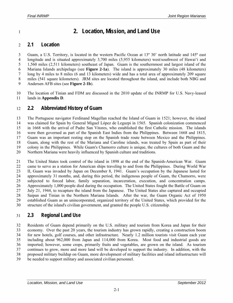
Final INRMP Joint Region Marianas
Location, Mission, and Land Use September 2012
2-1
2. Location, Mission, and Land Use 1
2.1 Location 2
Guam, a U.S. Territory, is located in the western Pacific Ocean at 13º 30’ north latitude and 145º east 3 longitude and is situated approximately 3,700 miles (5,955 kilometers) west/southwest of Hawai‘i and 4 1,560 miles (2,511 kilometers) southeast of Japan. Guam is the southernmost and largest island of the 5 Mariana Islands archipelago (see Figure 2-1a). The island is approximately 30 miles (48 kilometers) 6 long by 4 miles to 8 miles (6 and 13 kilometers) wide and has a total area of approximately 209 square 7 miles (541 square kilometers). JRM sites are located throughout the island, and include both NBG and 8 Andersen AFB sites (see Figure 2-1b). 9
The location of Tinian and FDM are discussed in the 2010 update of the INRMP for U.S. Navy-leased 10 lands in Appendix D. 11
2.2 Abbreviated History of Guam 12
The Portuguese navigator Ferdinand Magellan reached the Island of Guam in 1521; however, the island 13 was claimed for Spain by General Miguel López de Legazpi in 1565. Spanish colonization commenced 14 in 1668 with the arrival of Padre San Vitores, who established the first Catholic mission. The islands 15 were then governed as part of the Spanish East Indies from the Philippines. Between 1668 and 1815, 16 Guam was an important resting stop on the Spanish trade route between Mexico and the Philippines. 17 Guam, along with the rest of the Mariana and Caroline islands, was treated by Spain as part of their 18 colony in the Philippines. While Guam's Chamorro culture is unique, the cultures of both Guam and the 19 Northern Mariana were heavily influenced by Spanish culture and traditions. 20
The United States took control of the island in 1898 at the end of the Spanish-American War. Guam 21 came to serve as a station for American ships traveling to and from the Philippines. During World War 22 II, Guam was invaded by Japan on December 8, 1941. Guam’s occupation by the Japanese lasted for 23 approximately 31 months, and, during this period, the indigenous people of Guam, the Chamorro, were 24 subjected to forced labor, family separation, incarceration, execution, and concentration camps. 25 Approximately 1,000 people died during the occupation. The United States fought the Battle of Guam on 26 July 21, 1944, to recapture the island from the Japanese. The United States also captured and occupied 27 Saipan and Tinian in the Northern Mariana Islands. After the war, the Guam Organic Act of 1950 28 established Guam as an unincorporated, organized territory of the United States, which provided for the 29 structure of the island's civilian government, and granted the people U.S. citizenship. 30
2.3 Regional Land Use 31
Residents of Guam depend primarily on the U.S. military and tourism from Korea and Japan for their 32 economy. Over the past 20 years, the tourism industry has grown rapidly, creating a construction boom 33 for new hotels, golf courses, and other infrastructure. Nearly 1.2 million tourists visit Guam each year 34 including about 962,000 from Japan and 114,000 from Korea. Most food and industrial goods are 35 imported; however, some crops, primarily fruits and vegetables, are grown on the island. As tourism 36 continues to grow, more and more land will be developed to support the industry. In addition, with the 37 proposed military buildup on Guam, more development of military facilities and island infrastructure will 38 be needed to support military and associated civilian personnel. 39
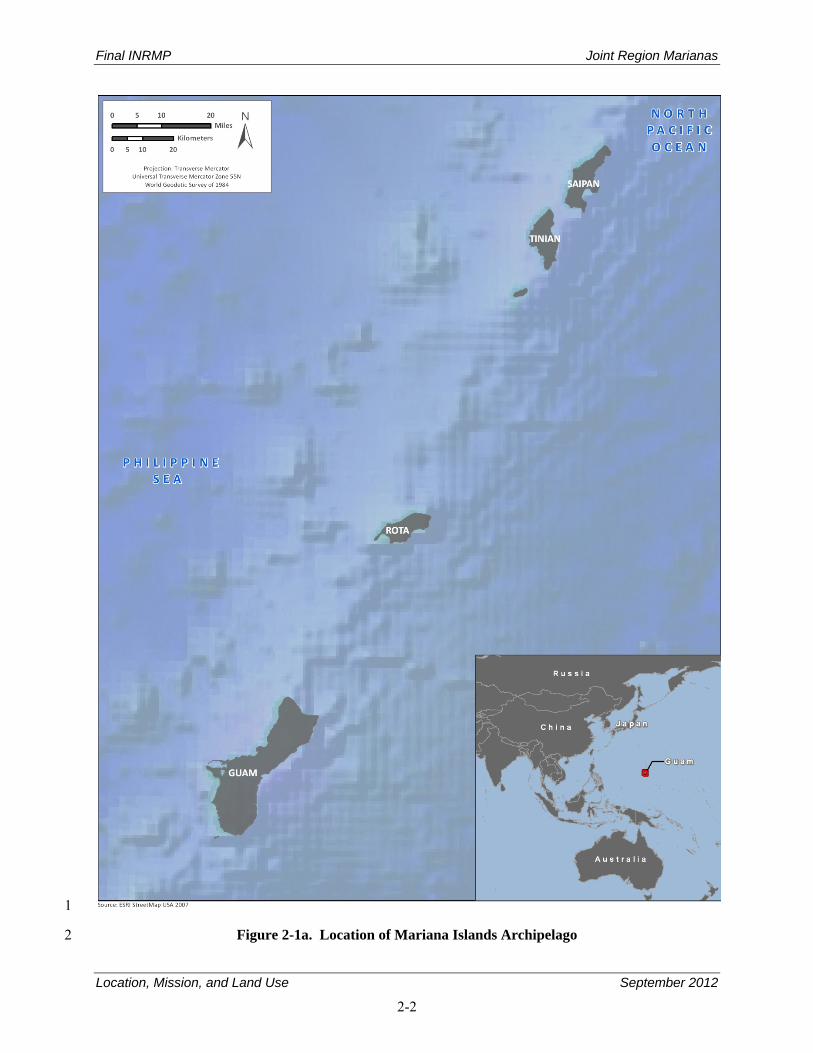
Final INRMP Joint Region Marianas
Location, Mission, and Land Use September 2012
2-2
1
Figure 2-1a. Location of Mariana Islands Archipelago 2
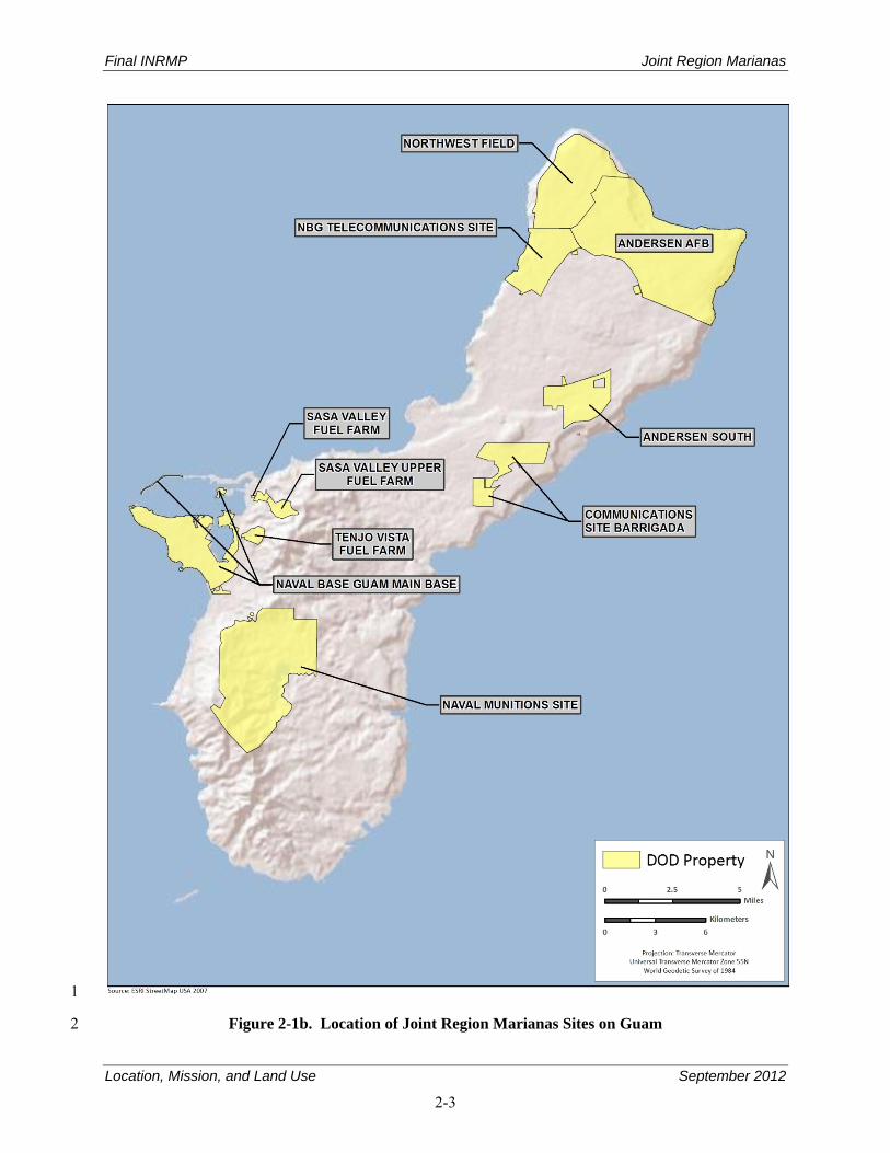
Final INRMP Joint Region Marianas
Location, Mission, and Land Use September 2012
2-3
1
Figure 2-1b. Location of Joint Region Marianas Sites on Guam 2
Final INRMP Joint Region Marianas
Location, Mission, and Land Use September 2012
2-4
2.4 Military Mission 1
The following sections describe the military missions of the NBG and Andersen AFB components of 2 JRM. A 2006 agreement between the United States and Japan is currently in the process of shifting 3 marines of the U.S. Marine Corps’ III Marine Expeditionary Force (III MEF) from installations in Japan 4 to the Island of Guam, which will enhance the military mission of JRM. 5
2.4.1 Naval Base Guam 6
The mission of NBG is to support the U.S. Pacific Fleet and other forces operating from, serviced by, or 7 supplied through Guam; to support the fighters based here or attached to tenant commands; and to support 8 the families of sailors stationed in Guam. 9
2.4.2 Andersen Air Force Base 10
The mission of the 36th Wing (36 WG) is “to provide a U.S.-based lethal warfighting platform for the 11 employment, deployment, reception, and throughput of air and space forces in the Asia-Pacific region.” 12 Guam serves as a stopping point for numerous aircraft enroute to Japan, Korea, and other Asian locations. 13 While Andersen AFB is a Navy installation, mission-support activities conducted at Andersen AFB are an 14 Air Force mission function (e.g., runways), while installation-support activities are a JRM function. 15
2.5 Operations and Activities and Their Effects on the Natural Environment 16
JRM, which includes Navy and Air Force holdings on Guam, and U.S. Navy-leased lands on Tinian and 17 FDM, is under CNIC. The following sections describe the operations and general associated 18 environmental effects of NBG and Andersen AFB sites that are now compose JRM. JRM sites on Tinian 19 and FDM are discussed in the 2010 update of the INRMP for U.S. Navy-leased lands on Tinian and FDM 20 in Appendix D. 21
The Navy supports numerous tenant commands and activities on four primary sites: NBG Main Base, 22 NMS, Main Cantonment Area, and Communications Site Barrigada (see Figure 2-1b). In total, Navy 23 lands on Guam cover 19,805 acres (8,015 hectares). In addition, the Navy manages all submerged lands 24 adjacent to its holdings from the shoreline out 3 nautical miles. Navy submerged lands total 25 approximately 79,260 acres (32,075 hectares). 26
The main installation of Andersen AFB is about 8 miles by 4 miles (13 by 6 kilometers) and covers 27 25 square miles (64 square kilometers), or about 16,021 acres (6,483 hectares), of a relatively flat, 28 uplifted limestone plateau at the northern end of the island (see Figure 2-1b). 29
2.5.1 Naval Base Guam Main Base 30
2.5.1.1 Operations 31
NBG Main Base is composed of several noncontiguous areas that were previously separate installations 32 (see Figure 2-2). NBG Main Base, approximately 6,205 acres (2,511 hectares), consists of several sites 33 including Main Base (3,114acres [1,260 hectares]), Tenjo and Sasa Fuel farms (651 acres 34 [263 hectares]), Glass Breakwater (41 acres [17 hectares]), Polaris Point (254 acres [103 hectares]), and 35 Drydock Island (48 acres [19 hectares]) to name a few. 36
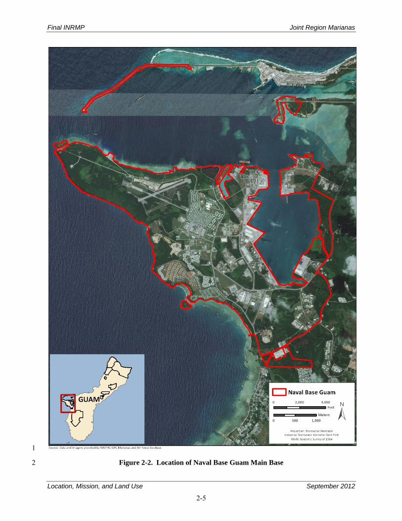
Final INRMP Joint Region Marianas
Location, Mission, and Land Use September 2012
2-5
1
Figure 2-2. Location of Naval Base Guam Main Base 2
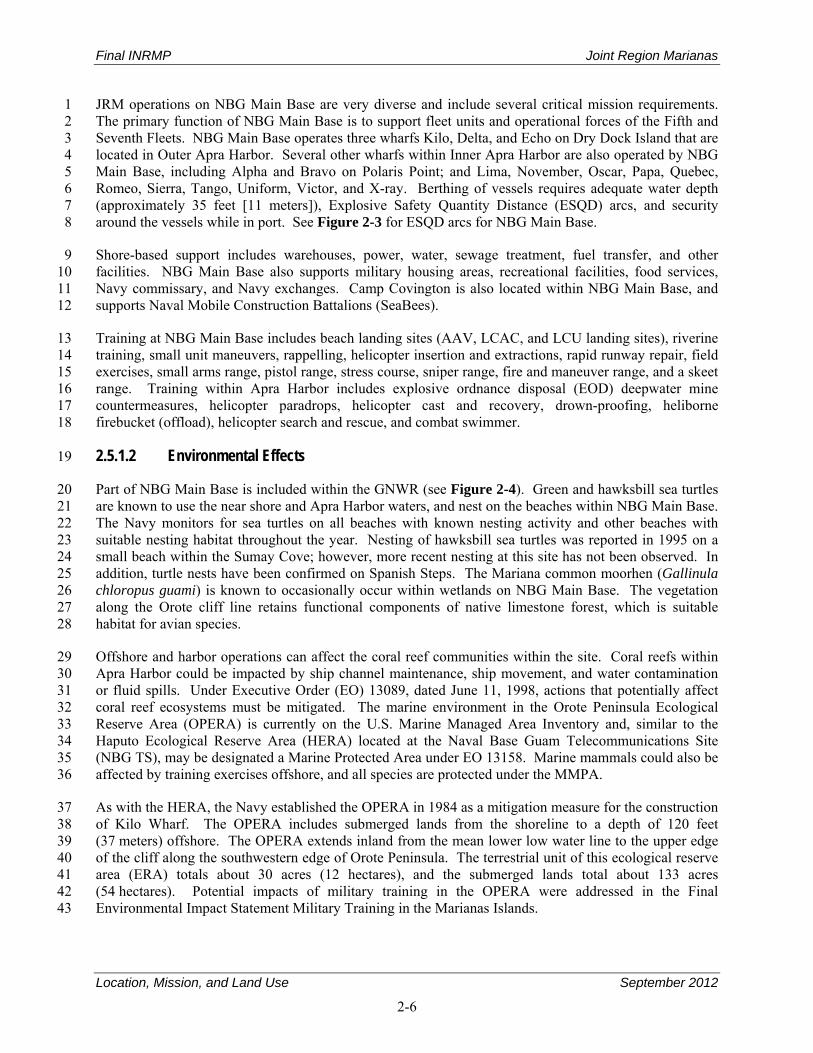
Final INRMP Joint Region Marianas
Location, Mission, and Land Use September 2012
2-6
JRM operations on NBG Main Base are very diverse and include several critical mission requirements. 1 The primary function of NBG Main Base is to support fleet units and operational forces of the Fifth and 2 Seventh Fleets. NBG Main Base operates three wharfs Kilo, Delta, and Echo on Dry Dock Island that are 3 located in Outer Apra Harbor. Several other wharfs within Inner Apra Harbor are also operated by NBG 4 Main Base, including Alpha and Bravo on Polaris Point; and Lima, November, Oscar, Papa, Quebec, 5 Romeo, Sierra, Tango, Uniform, Victor, and X-ray. Berthing of vessels requires adequate water depth 6 (approximately 35 feet [11 meters]), Explosive Safety Quantity Distance (ESQD) arcs, and security 7 around the vessels while in port. See Figure 2-3 for ESQD arcs for NBG Main Base. 8
Shore-based support includes warehouses, power, water, sewage treatment, fuel transfer, and other 9 facilities. NBG Main Base also supports military housing areas, recreational facilities, food services, 10 Navy commissary, and Navy exchanges. Camp Covington is also located within NBG Main Base, and 11 supports Naval Mobile Construction Battalions (SeaBees). 12
Training at NBG Main Base includes beach landing sites (AAV, LCAC, and LCU landing sites), riverine 13 training, small unit maneuvers, rappelling, helicopter insertion and extractions, rapid runway repair, field 14 exercises, small arms range, pistol range, stress course, sniper range, fire and maneuver range, and a skeet 15 range. Training within Apra Harbor includes explosive ordnance disposal (EOD) deepwater mine 16 countermeasures, helicopter paradrops, helicopter cast and recovery, drown-proofing, heliborne 17 firebucket (offload), helicopter search and rescue, and combat swimmer. 18
2.5.1.2 Environmental Effects 19
Part of NBG Main Base is included within the GNWR (see Figure 2-4). Green and hawksbill sea turtles 20 are known to use the near shore and Apra Harbor waters, and nest on the beaches within NBG Main Base. 21 The Navy monitors for sea turtles on all beaches with known nesting activity and other beaches with 22 suitable nesting habitat throughout the year. Nesting of hawksbill sea turtles was reported in 1995 on a 23 small beach within the Sumay Cove; however, more recent nesting at this site has not been observed. In 24 addition, turtle nests have been confirmed on Spanish Steps. The Mariana common moorhen (Gallinula 25 chloropus guami) is known to occasionally occur within wetlands on NBG Main Base. The vegetation 26 along the Orote cliff line retains functional components of native limestone forest, which is suitable 27 habitat for avian species. 28
Offshore and harbor operations can affect the coral reef communities within the site. Coral reefs within 29 Apra Harbor could be impacted by ship channel maintenance, ship movement, and water contamination 30 or fluid spills. Under Executive Order (EO) 13089, dated June 11, 1998, actions that potentially affect 31 coral reef ecosystems must be mitigated. The marine environment in the Orote Peninsula Ecological 32 Reserve Area (OPERA) is currently on the U.S. Marine Managed Area Inventory and, similar to the 33 Haputo Ecological Reserve Area (HERA) located at the Naval Base Guam Telecommunications Site 34 (NBG TS), may be designated a Marine Protected Area under EO 13158. Marine mammals could also be 35 affected by training exercises offshore, and all species are protected under the MMPA. 36
As with the HERA, the Navy established the OPERA in 1984 as a mitigation measure for the construction 37 of Kilo Wharf. The OPERA includes submerged lands from the shoreline to a depth of 120 feet 38 (37 meters) offshore. The OPERA extends inland from the mean lower low water line to the upper edge 39 of the cliff along the southwestern edge of Orote Peninsula. The terrestrial unit of this ecological reserve 40 area (ERA) totals about 30 acres (12 hectares), and the submerged lands total about 133 acres 41 (54 hectares). Potential impacts of military training in the OPERA were addressed in the Final 42 Environmental Impact Statement Military Training in the Marianas Islands. 43
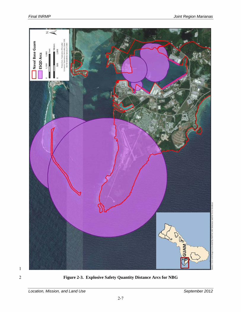
Final INRMP Joint Region Marianas
Location, Mission, and Land Use September 2012
2-7
1
Figure 2-3. Explosive Safety Quantity Distance Arcs for NBG 2
Final INRMP Joint Region Marianas
Location, Mission, and Land Use September 2012
2-8
1
Figure 2-4. Guam National Wildlife Refuge Areas on Naval Base Guam Main Base 2 and Naval Munitions Site 3
4
Final INRMP Joint Region Marianas
Location, Mission, and Land Use September 2012
2-9
In addition, Guam is within the jurisdiction of the Western Pacific Regional Fishery Management Council 1 (WPRFMC), which has designated the marine waters around Guam, including Navy submerged lands, as 2 Essential fish habitat (EFH), and waters between 130 to 980 feet (40 and 280 meters) as bottom-fish 3 Habitat of Particular Concern (HAPC) (Western Pacific Regional Fishery Management Council, 1998). 4
The shoreline and cliff lines along NBG Main Base, as well as wetlands, and upland grass fields, support 5 a number of seabird and migratory shorebird species, which are protected under the Migratory Bird 6 Treaty Act (MBTA). Certain activities, such as land clearing, can inadvertently impact these birds. There 7 are several wetlands within NBG Main Base that are regulated by the U.S. Army Corps of Engineers 8 (USACE). Wetlands in Guam are also protected under EO 78-21, EO 90-13, EO 99-09, The Guam Water 9 Pollution Control Act, and Guam’s Wetland and Flood Hazard Area Regulations (Title 13, Subchapter E. 10 Section 12240-12246 and Subchapter D, Section 12230-12236, Administrative Rules and Regulations). 11 Wetlands can be affected by operations on NBG Main Base due to construction or other activities that 12 require filling or from activities that cause erosion and sedimentation, which can degrade wetland quality. 13
Vegetated areas that have been disturbed by clearing, construction, and other activities are dominated by 14 nonnative and invasive plant species, and include a number of invasive weeds. 15
2.5.2 Naval Munitions Site 16
2.5.2.1 Operations 17
The NMS is the largest JRM site on Guam and has the greatest area of terrestrial natural resources. 18 Located on mountainous terrain in south-central Guam, the site consists of approximately 8,800 acres 19 (3,561 hectares) of which half lies within the watershed of Fena Reservoir (see Figure 2-5). 20
The NMS provides support through receiving, renovating, maintaining, storing, and issuing ammunition, 21 explosives, and expendable ordnance materials to units of the Pacific Fleet operating in the Western 22 Pacific. The site has the primary responsibility of providing ordnance support for the Seventh and Fifth 23 Fleets and has been designated as the single transportation service for point-to-point ammunition hauling 24 between military installations on Guam. Magazines at the NMS provide more than 250,000 square feet 25 (76,200 meters) of storage space for ordnance materials. 26
Because of the ESQDs of the NMS, there has been limited development (see Figure 2-6). Approximately 27 70 percent of the site’s land is retained as uninhabited land used as an explosive safety zone. The 28 facilities located within this zone include ordnance storage magazines, ordnance operating and support 29 buildings, the Fena Reservoir Dam, and an extensive network of roads. The remaining land in this area is 30 managed primarily for conservation and watershed. 31
Fena Dam, built in 1951, contains Fena Reservoir, the largest freshwater body of water on Guam, with a 32 maximum storage capacity of about 7,500 acre-feet (925 hectare-meters). Fena Reservoir provides the 33 majority of Navy’s water. Surplus water is sold to GovGuam for distribution to residents in southern 34 Guam. The Fena Water Treatment Plant is operated by NAVFACMAR. 35
Training within the NMS includes helicopter landings, field exercises, paradrops, small unit bivouac, land 36 navigation, patrols, squad tactics, heliborne firebucket loading, tactical rescue of aircraft and personnel, 37 escape and evasion, sniper range use, and small unit patrolling. 38

Final INRMP Joint Region Marianas
Location, Mission, and Land Use September 2012
2-10
1
Figure 2-5. Location of the Naval Munitions Site 2
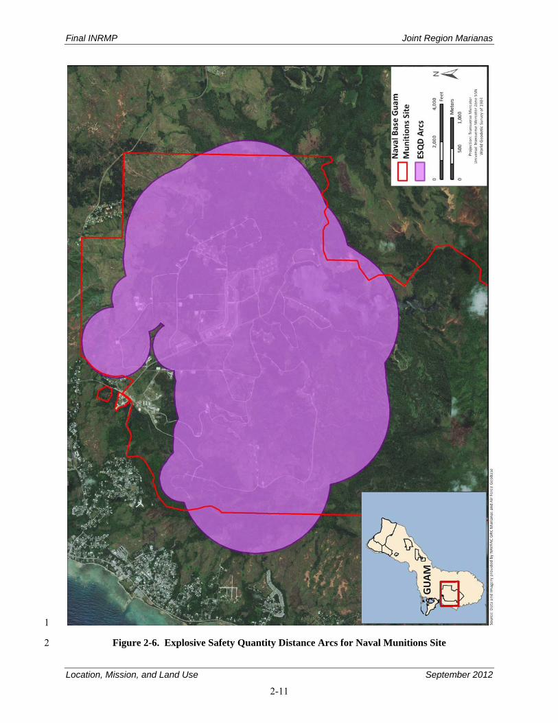
Final INRMP Joint Region Marianas
Location, Mission, and Land Use September 2012
2-11
1
Figure 2-6. Explosive Safety Quantity Distance Arcs for Naval Munitions Site 2
Final INRMP Joint Region Marianas
Location, Mission, and Land Use September 2012
2-12
2.5.2.2 Environmental Effects 1
The majority of the NMS is included within the GNWR (see Figure 2-4). Three caves within the NMS 2 contain the only nesting populations of Mariana swiftlets (Aerodramus bartschi) on Guam. The Mariana 3 common moorhen is also known to inhabit the shoreline of Fena Reservoir and many other wetlands on 4 the NMS. Plant communities within the NMS retain functional components of native ravine and 5 limestone forest, which is suitable habitat for the swiftlet and moorhen. The Mariana fruit bat (Pteropus 6 mariannus mariannus) has been sighted foraging in the site, and the USFWS recovery plan for the 7 Mariana fruit bat identified the Fena watershed as the largest parcel of suitable habitat for the bat in 8 southern Guam. Training exercises could affect these species if they take place within close proximity to 9 nesting and foraging areas. 10
Migratory birds, which are protected under the Migratory Bird Treaty Act (MBTA), are frequently 11 observed foraging and roosting on Fena Reservoir and along its shores and upland habitats along the 12 NMS. Operational activities around Fena Reservoir could cause further development and habitat loss 13 which could affect these birds. 14
As with all other sites, the area has been heavily disturbed and is, therefore, dominated by nonnative, 15 often invasive species. EO 13112 outlines the Federal government’s responsibilities to prevent the 16 introduction and provide for the control of invasive species. In addition to invasive vegetation, the NMS 17 has a high population of invasive ungulates that impact vegetation communities, which in turn leads to 18 habitat degradation, increased erosion, and reduced water quality. 19
2.5.3 Naval Base Guam Telecommunications Site 20
2.5.3.1 Operations 21
NBG TS is located on the northwestern side of Guam and totals 3,000 acres (1,214 hectares) (see 22 Figure 2-7). NBG TS operates communications systems including radio frequency (RF) systems and 23 terrestrial-based fiber optic cables at this site. This area is designated as, and must be maintained as, an 24 RF quiet zone for a minimum of a 1-mile (1.6 kilometer) radius. The South Finegayan housing area is in 25 a separate parcel south of NBG TS. The Navy mission requirement for the family housing area is to 26 provide a safe, secure environment for the residents of the housing area. 27
The Navy also owns the submerged lands off of NBG TS at a distance of 12 miles (19 kilometers) from 28 the coast but actively manages up to 3 nautical miles (5.5 kilometers) seaward. These waters off the site 29 are used for military training. Authorized training at NBG TS includes training for Navy Special Warfare 30 Units, Special Forces, and Marine Reconnaissance teams; use of existing trails for inland maneuvers and 31 Military Operations in Urbanized Terrain (MOUT), and the use of small arms at the North Range. 32
2.5.3.2 Environmental Effects 33
Land clearing and training exercises can affect endangered species that occur or potentially occur within 34 the site by disturbing or removing habitat or food sources. Two endangered species and four candidate 35 species have been documented within the site: the Mariana fruit bat and green sea turtles (Chelonia 36 mydas) are threatened; and the Mariana eight-spot (Hypolimnas octucual marianensis), the humped tree 37 snail (Partula givva), the Guam tree snail (Partula radiolata), and the fragile tree snail (Samoana fragilis) 38 are candidate species. Haputo Beach supports nesting sea turtles and nesting activity has been observed. 39
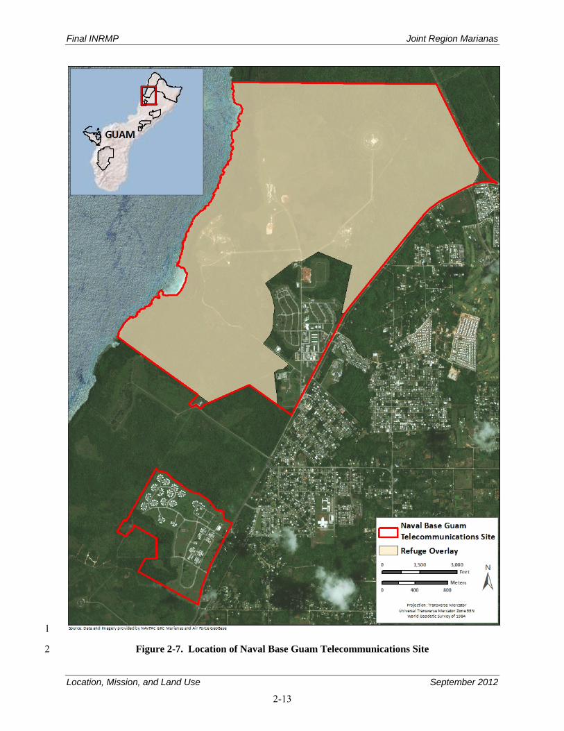
Final INRMP Joint Region Marianas
Location, Mission, and Land Use September 2012
2-13
1
Figure 2-7. Location of Naval Base Guam Telecommunications Site 2
Final INRMP Joint Region Marianas
Location, Mission, and Land Use September 2012
2-14
Coastal training can affect coral reef communities. Under EO 13089, actions that potentially affect coral 1 reef ecosystems must be mitigated. The marine environment in the HERA is currently on the U.S. Marine 2 Managed Area Inventory. Marine mammals can be affected by training exercises offshore. All species 3 are protected under the MMPA. 4
In 1984, the HERA was established as a mitigation measure for the construction of Kilo Wharf. The 5 HERA includes submerged lands from the shoreline to the outer edge of the reef margin. Inland the 6 HERA extends to the top of the limestone ridge along the full length of the coast. The terrestrial unit of 7 this HERA totals about 180 acres (73 hectares), and the submerged lands total 72 acres (29 hectares). 8 Potential impacts of military training in the HERA were addressed in the Final Environmental Impact 9 Statement Military Training In the Marianas Islands. 10
The shoreline and cliff line along NBG TS and upland habitats, support a number of shorebird species, 11 which are protected under the MBTA, and training activities in this area can affect these birds. 12 EO 13186, Responsibilities of Federal Agencies to Protect Migratory Birds, outlines Federal agencies’ 13 responsibilities to promote the conservation of migratory bird populations, and consultation with the 14 USFWS if any planned action could harm migratory bird species listed in 50 CFR § 10.21. 15
Receiving antennas and other communications equipment require open areas to prevent interference from 16 surrounding trees or buildings. As a result, much of NBG TS been cleared and is maintained as mowed 17 grasslands. This has allowed for the establishment of nonnative vegetation primarily in the transition 18 areas between the mowed grasslands and the forest areas. These species have also moved into the forest 19 areas, especially along the roadsides where safety areas are maintained. This disturbance and increase in 20 nonnative vegetation has contributed to a highly disturbed habitat and a severe decline in native forest 21 species and suitable habitat for invasive ungulate species. 22
2.5.4 Communications Site Barrigada 23
2.5.4.1 Operations 24
The Communications Site Barrigada is located on the northeastern side of Guam (see Figure 2-8). The 25 site is approximately 1,800 acres (728 hectares) and supports a large antenna field developed around an 26 active transmitter facility. The facility serves as the transmitting station for NBG TS. A one-mile 27 (2-kilometer) radius protection zone is designated around transmitting antennas to preclude 28 electromagnetic radiation problems. Fifteen acres (6 hectares) are leased to the Guam Army National 29 Guard for small-unit tactics and land navigation training. The Navy’s Admiral Nimitz Golf Course 30 includes several small man-made ponds. The ponds are ephemeral and do not support wetland 31 vegetation. 32
2.5.4.2 Environmental Effects 33
The open grasslands and constructed wetlands within Communication Site Barrigada are regularly used as 34 resting and foraging areas for migrating birds, which are protected under the MBTA. 35
As with the NBG TS, the activities carried out at this site require large amounts of cleared, maintained 36 land for operation. The disturbance of land has led to an increase of nonnative and invasive species. 37 Additionally, there is native understory, and canopy trees within this site for the Mariana fruit bat. 38
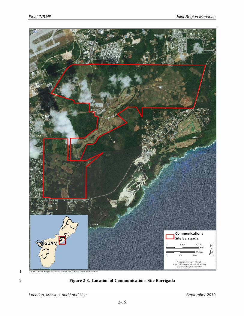
Final INRMP Joint Region Marianas
Location, Mission, and Land Use September 2012
2-15
1
Figure 2-8. Location of Communications Site Barrigada 2
Final INRMP Joint Region Marianas
Location, Mission, and Land Use September 2012
2-16
2.5.5 Andersen Air Force Base 1
2.5.5.1 Operations 2
Andersen AFB covers approximately 16,021 acres (6,483 hectares). The main operations area of 3 Andersen AFB is in the eastern third of the installation at approximately 500 feet (152 meters) above sea 4 level and includes the main active airfield and an array of operations, maintenance, and community 5 support facilities (see Figures 2-9a and 2-9b). The central third of the installation is a Munitions Storage 6 Area. The western third is Northwest Field, a World War II-era airfield used for fixed-wing aircraft and 7 helicopter training and various field exercises and bivouacs. 8
Andersen AFB is vital to the security of the United States and its mission is expanding to support the new 9 defense strategy specified in the 2001 Quadrennial Defense Review and the 2003 Defense Planning 10 Guidance. This new defense strategy calls for the military to “deter forward” by stationing or deploying 11 forces to five critical regions of the world: Europe, Middle East, Southwest Asia, Northeast Asia, and 12 East Asian Littoral (e.g., region stretching from south of Japan through Australia and into the Bay of 13 Bengal). Under this new defense strategy, Andersen AFB is proposed as a main operating base to 14 conduct and support operations in the East Asian Littoral region due to its long runways, vast ramp space, 15 and large fuel storage capacity. Andersen AFB would be used for potential strikes with bombers or 16 fighters; for Command and Control; for Intelligence, Surveillance, and Reconnaissance; and for air 17 refueling, airlift, and Search and Rescue. 18
Major units of the 36 WG include the 36th Mission Support Group (36 MSG), the 36th Logistics Group 19 (36 LG), 36th Medical Group (36 MDG), and the 36th Operation Support Squadron (36 OSS). The 20 36 MSG maintains an infrastructure of communications, engineering, information management, and 21 security; and provides critical personnel support and morale, recreation, and services. The 36 LG 22 provides superior transportation, aircraft maintenance/munitions, supply/fuel, contracting, and logistics 23 planning. 24
2.5.5.2 Environmental Effects 25
Training and Support Operations 26
Northwest Field. Northwest Field is an unimproved expeditionary World-War-II-era airfield that is used 27 for vertical and short field landings. Approximately 280 acres of land are cleared near the eastern end of 28 both runways for parachute drop training. The south runway is used for training of short field and vertical 29 lift aircraft and often supports various types of ground maneuver training. Helicopter units use other 30 paved surfaces for Confined Area Landing, simulated amphibious ship helicopter deck landings, and 31 insertions and extractions of small maneuver teams (U.S. Navy 2010b). 32
About 3,562 acres (1,442 hectares) in Northwest Field are the primary maneuver training areas available 33 at Andersen AFB for field exercises and bivouacs. Routine training exercises include camp/tent setup, 34 survival skills, land navigation, day/night tactical maneuvers and patrols, blank ammunition and 35 pyrotechnics firing, treatment and evaluation of casualties, fire safety, weapons security training, 36 perimeter defense/security, field equipment training, and chemical attack/response (U.S. Navy 2010b). 37 The 36th Civil Engineering Squadron Environmental Flight (36 CES/CEV) routinely conducts a NEPA 38 review for all training exercises conducted at Northwest Field. 39
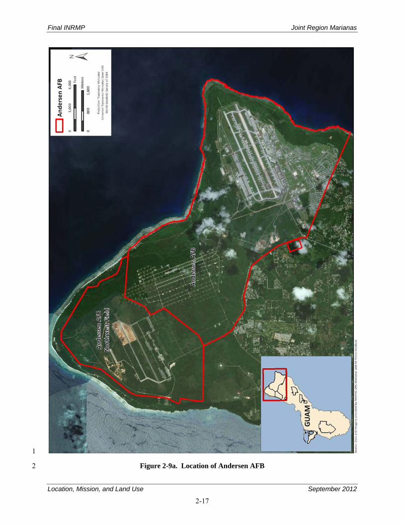
Final INRMP Joint Region Marianas
Location, Mission, and Land Use September 2012
2-17
1
Figure 2-9a. Location of Andersen AFB 2
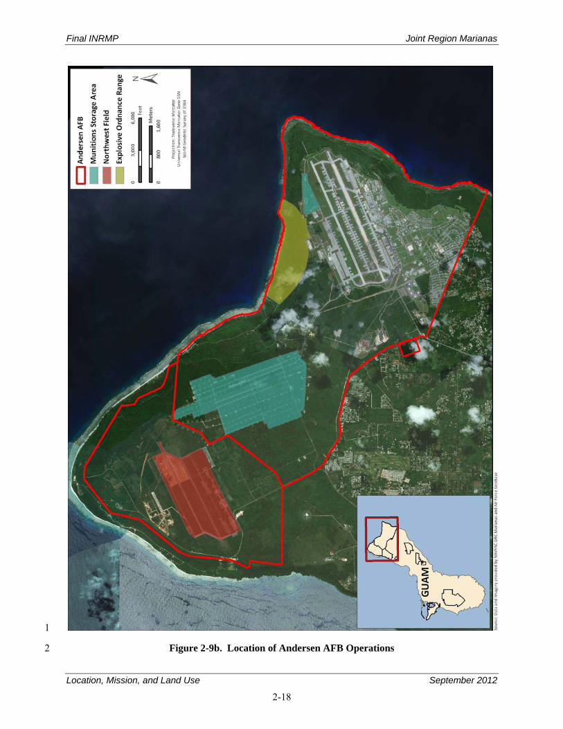
Final INRMP Joint Region Marianas
Location, Mission, and Land Use September 2012
2-18
1
Figure 2-9b. Location of Andersen AFB Operations 2
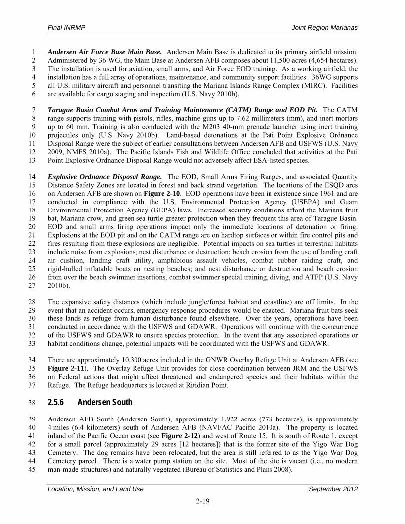
Final INRMP Joint Region Marianas
Location, Mission, and Land Use September 2012
2-19
Andersen Air Force Base Main Base. Andersen Main Base is dedicated to its primary airfield mission. 1 Administered by 36 WG, the Main Base at Andersen AFB composes about 11,500 acres (4,654 hectares). 2 The installation is used for aviation, small arms, and Air Force EOD training. As a working airfield, the 3 installation has a full array of operations, maintenance, and community support facilities. 36WG supports 4 all U.S. military aircraft and personnel transiting the Mariana Islands Range Complex (MIRC). Facilities 5 are available for cargo staging and inspection (U.S. Navy 2010b). 6
Tarague Basin Combat Arms and Training Maintenance (CATM) Range and EOD Pit. The CATM 7 range supports training with pistols, rifles, machine guns up to 7.62 millimeters (mm), and inert mortars 8 up to 60 mm. Training is also conducted with the M203 40-mm grenade launcher using inert training 9 projectiles only (U.S. Navy 2010b). Land-based detonations at the Pati Point Explosive Ordnance 10 Disposal Range were the subject of earlier consultations between Andersen AFB and USFWS (U.S. Navy 11 2009, NMFS 2010a). The Pacific Islands Fish and Wildlife Office concluded that activities at the Pati 12 Point Explosive Ordnance Disposal Range would not adversely affect ESA-listed species. 13
Explosive Ordnance Disposal Range. The EOD, Small Arms Firing Ranges, and associated Quantity 14 Distance Safety Zones are located in forest and back strand vegetation. The locations of the ESQD arcs 15 on Andersen AFB are shown on Figure 2-10. EOD operations have been in existence since 1961 and are 16 conducted in compliance with the U.S. Environmental Protection Agency (USEPA) and Guam 17 Environmental Protection Agency (GEPA) laws. Increased security conditions afford the Mariana fruit 18 bat, Mariana crow, and green sea turtle greater protection when they frequent this area of Tarague Basin. 19 EOD and small arms firing operations impact only the immediate locations of detonation or firing. 20 Explosions at the EOD pit and on the CATM range are on hardtop surfaces or within fire control pits and 21 fires resulting from these explosions are negligible. Potential impacts on sea turtles in terrestrial habitats 22 include noise from explosions; nest disturbance or destruction; beach erosion from the use of landing craft 23 air cushion, landing craft utility, amphibious assault vehicles, combat rubber raiding craft, and 24 rigid-hulled inflatable boats on nesting beaches; and nest disturbance or destruction and beach erosion 25 from over the beach swimmer insertions, combat swimmer special training, diving, and ATFP (U.S. Navy 26 2010b). 27
The expansive safety distances (which include jungle/forest habitat and coastline) are off limits. In the 28 event that an accident occurs, emergency response procedures would be enacted. Mariana fruit bats seek 29 these lands as refuge from human disturbance found elsewhere. Over the years, operations have been 30 conducted in accordance with the USFWS and GDAWR. Operations will continue with the concurrence 31 of the USFWS and GDAWR to ensure species protection. In the event that any associated operations or 32 habitat conditions change, potential impacts will be coordinated with the USFWS and GDAWR. 33
There are approximately 10,300 acres included in the GNWR Overlay Refuge Unit at Andersen AFB (see 34 Figure 2-11). The Overlay Refuge Unit provides for close coordination between JRM and the USFWS 35 on Federal actions that might affect threatened and endangered species and their habitats within the 36 Refuge. The Refuge headquarters is located at Ritidian Point. 37
2.5.6 Andersen South 38
Andersen AFB South (Andersen South), approximately 1,922 acres (778 hectares), is approximately 39 4 miles (6.4 kilometers) south of Andersen AFB (NAVFAC Pacific 2010a). The property is located 40 inland of the Pacific Ocean coast (see Figure 2-12) and west of Route 15. It is south of Route 1, except 41 for a small parcel (approximately 29 acres [12 hectares]) that is the former site of the Yigo War Dog 42 Cemetery. The dog remains have been relocated, but the area is still referred to as the Yigo War Dog 43 Cemetery parcel. There is a water pump station on the site. Most of the site is vacant (i.e., no modern 44 man-made structures) and naturally vegetated (Bureau of Statistics and Plans 2008). 45
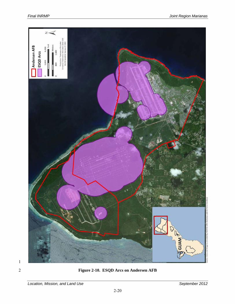
Final INRMP Joint Region Marianas
Location, Mission, and Land Use September 2012
2-20
1
Figure 2-10. ESQD Arcs on Andersen AFB 2
Final INRMP Joint Region Marianas
Location, Mission, and Land Use September 2012
2-21
1
Figure 2-11. Guam National Wildlife Refuge Areas on Andersen Air Force Base 2 3
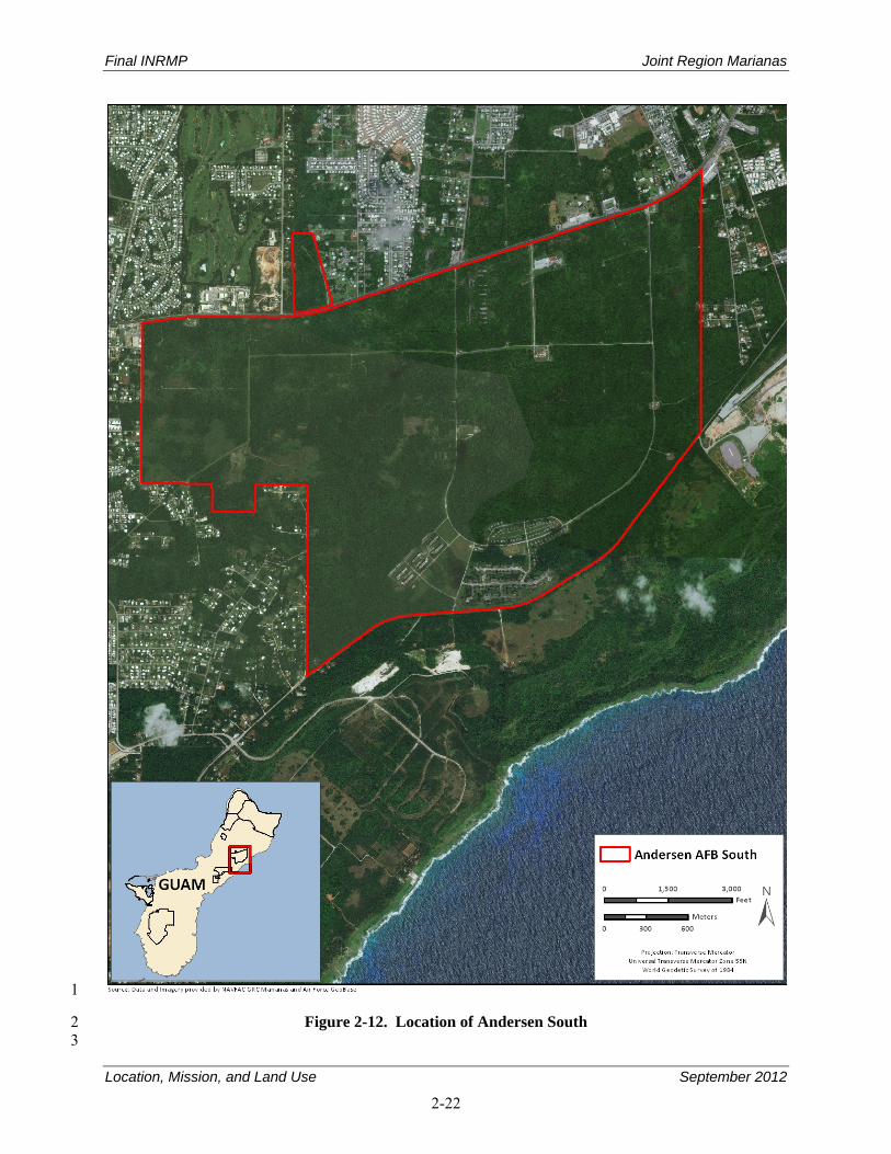
Final INRMP Joint Region Marianas
Location, Mission, and Land Use September 2012
2-22
1
Figure 2-12. Location of Andersen South 2 3
Final INRMP Joint Region Marianas
Location, Mission, and Land Use September 2012
2-23
Andersen South is an abandoned U.S. Air Force (USAF) housing area now used as a joint services 1 ground-training site. The abandoned structures, which are situated adjacent to Route 15 along a relatively 2 small portion on the southwest side of the site, are used for urban warfare training (JGPO 2010). The 3 remainder of the Andersen South site is largely composed of an old road network and a few dispersed 4 facilities that are surrounded by moderate-to-dense vegetation. Andersen South and the surrounding 5 community of Yigo are situated on relatively flat topography and thus do not afford much in the way of 6 views from adjacent roadways, which are blocked by the dense vegetation (JGPO 2010). 7
2.5.6.1 Operations 8
The Andersen South area consists of open fields, wooded areas, and vacant houses that have been used 9 for humanitarian operations, staging, bivouac, equipment inspection, and small unit tactics. The most 10 intensive use at Andersen South currently occurs during exercises involving up to three Marine Corps 11 companies that use the Andersen South range for up to 3 weeks, which currently occurs twice a year. 12 Blanks used in this training produce an estimated noise level of about 96 A-weighted decibels (dBA) at a 13 distance of 500 feet (152 meters) and about 90 dBA at a distance of 1,000 feet (305 meters), which 14 exceeds compatible noise levels for residential use. There are no residences at Andersen South. The 15 noise levels diminish with distance and the noise levels do not encroach on the surrounding community. 16 MOUT training is conducted in abandoned housing areas. There are installation restoration (clean-up) 17 sites and water production wells with wellhead clearance buffers in the area. Historically, the site was 18 used for family housing and barracks, and includes a wastewater pump station, water booster pump 19 station, water tanks and electrical substation that are not currently being used (NAVFAC Pacific 2010a). 20
2.5.6.2 Environmental Effects 21
Based on review of Volume 2, Chapter 8, Land and Submerged Land Use of the Final Environmental 22 Impact Statement for the relocation of Marines from Okinawa, proposed uses of the Andersen South 23 would not pose a significant environmental impact because the parcel is not located on the coast and only 24 minor changes in land ownership are anticipated (NAVFAC Pacific 2010a). 25
Final INRMP Joint Region Marianas
Location, Mission, and Land Use September 2012
2-24
THIS PAGE INTENTIONALLY LEFT BLANK 1
Final INRMP Joint Region Marianas
Environmental Management Strategy and Mission Sustainability September 2012
3-1
3. Environmental Management Strategy and Mission Sustainability 1
3.1 Natural Resources Management Strategy 2
Natural resources management conducted by the JRM sites on Guam strives to integrate biodiversity 3 conservation and an ecosystem-based approach into an adaptive management framework compatible with 4 the military mission. As a result, the natural resources program consists of multiple resource disciplines 5 that are frequently interconnected and share similar objectives. Management projects and plans often 6 consist of multiple program elements with several different resource experts collaborating together. This 7 section describes the various natural resources Program Elements along with their primary goals and 8 objectives. 9
The Navy is the lead service for natural resources management of DOD lands on Guam. As such, Navy 10 policy on natural resources management, as summarized from OPNAVINST 5090.1C CH-1, is to manage 11 natural resources to support and be consistent with the military mission, while protecting and enhancing 12 those resources for multiple use, sustainable yield, and biological integrity. Land use practices and 13 decisions must be based on scientifically sound conservation procedures and techniques, and use 14 scientific methods and an ecosystem management approach. 15
Employing ecosystem management helps maintain and improve the sustainability and biological diversity 16 of terrestrial and aquatic ecosystems while supporting sustainable economies, human use, and the 17 environment required for realistic military training operations (DOD 2011). 18
The basic principles and guidelines of ecosystem management are as follows: 19
Preserve the function and integrity of natural ecosystems 20 Integrate human social and economic interests with environmental considerations 21 Involve all interested parties (stakeholders) in identifying management goals 22 Adapt to changing conditions and requirements. 23
Ecosystem function is a result of interactions of its various components: geologic and soil features, 24 climatic elements, plants, animals, humans, and current and past disturbances (including past management 25 practices). The function and integrity of an ecosystem are measured in terms of diversity, nutrient 26 availability (productivity), and structural complexity. Assessing ecosystem health and sustainability 27 requires objectively measuring a set of parameters that can be used to describe conditions. Adaptive 28 management is an iterative cycle of planning, monitoring, evaluation, adjustment, and implementation 29 that is best used to assess ecosystem function and the effectiveness of management practices. 30
3.2 Cooperative, Adaptive, and Ecosystem Management 31
The 1994 DOD policy memorandum Implementation of Ecosystem Management in the DOD was 32 developed to ensure that resources on DOD installations were managed in a manner to conserve and 33 protect biological diversity through adopting an ecosystem management approach to natural resources 34 management (Benton et al. 2008). The policy states that “military installations will use ecosystem 35 management to: (1) restore and maintain ecological associations that are of local and regional importance 36 and compatible with existing geophysical components (e.g., soil, water); (2) restore and maintain 37 biological diversity; (3) restore and maintain ecological processes, structures, and functions; (4) adapt to 38 changing conditions, including changes resulting from a changing climate; (5) manage for viable 39 populations, and (6) maintain ecologically appropriate perspectives of time and space” (Benton et al. 40 2008). 41
Final INRMP Joint Region Marianas
Environmental Management Strategy and Mission Sustainability September 2012
3-2
The DOD leadership further strengthened the need to manage resources using an ecosystem management 1 approach in DOD Instruction 4715.03 (DOD 2011), that stressed the importance of recognizing the 2 relationship between ecosystem management and biodiversity conservation (Benton et al. 2008). The 3 instruction outlined five goals for installations to preserve and enhance biodiversity: “(1) maintain or 4 restore remaining native ecosystem types across their natural range of variation; (2) maintain or 5 reestablish viable populations of all native species in an installation’s areas of natural habitat, when 6 practical; (3) maintain evolutionary and ecological processes, such as disturbance regimes, hydrological 7 processes, and nutrient cycles; (4) manage over sufficiently long time periods for changing system 8 dynamics, including climate change; and (5) accommodate human use in those guidelines” (Benton et al. 9 2008). 10
With the passage of the SAIA in 1997, DOD ensured that all INRMPs were developed with an ecosystem 11 management approach to overall natural resources management. One of the primary facets of ecosystem 12 management is to maintain the ecological integrity of the area managed. Ecological integrity is defined as 13 “the ability to support and maintain a balanced, integrated, adaptive community of organisms having a 14 species composition, diversity, and functional organization comparable to that of natural habitat of the 15 region” (Benton et al. 2008). The INRMP is developed to conserve and protect ecological integrity by 16 promoting a proactive, as opposed to a reactive, strategy for managing resources. The SAIA also requires 17 that INRMPs are reviewed annually and updated every 5 years to ensure that these documents remain as 18 living documents that can be revised based on changes to current conditions (including changes as a result 19 of climate). The goals and objectives developed for this INRMP were developed using an ecosystem 20 management approach that is flexible and takes into account ecosystem changes resulting from various 21 factors including climate change. 22
The DoN has also developed the Cooperative Strategy for 21st Century Sea Power that addresses a need 23 for adaptive management in the face of a changing climate (U.S. Navy, U.S. Marine Corps and U.S. Coast 24 Guard 2007). In addition, the 2008 DoN Environmental Strategy, Sustaining our Environment, 25 Protecting our Freedom states the importance of all Naval bases to evaluate activities and ensure that best 26 management practices (BMPs) have been put into place to reduce the overall environmental footprint of 27 the Navy and enhance sustainability (U.S. Navy 2008). Finally, in May 2009, the DoN created a task 28 force to explore and develop policies and strategies that address climate change. The Task Force Climate 29 Change is made up of senior DoN staff and other stakeholders and findings will be based on many 30 factors, including the most current scientific research. 31
Management Strategy 32
Communication of Ecosystem Management Philosophy to JRM Personnel 33
There is an ongoing need for coordination between JRM and other agencies, and between the JRM and 34 interested and affected public entities during plan development and implementation to manage the 35 ecosystem effectively. 36
Objective: Develop the coordination necessary between JRM, other agencies, and public entities to 37 ensure that an effective and viable ecosystem management approach is developed. 38
Strategies: 39
1. Complete this version of the INRMP with concurrence from USFWS, GDAWR, and NMFS, and 40 use it as a beginning point to develop an ecosystem management approach to natural resources 41 management. 42
Final INRMP Joint Region Marianas
Environmental Management Strategy and Mission Sustainability September 2012
3-3
2. Develop a process and schedule for coordinating with agencies to allow for agency comment on 1 all natural resources management plans. 2
3. Coordinate resources management efforts and projects with other agencies including coordinated 3 monitoring programs and data sharing to take an island-wide (or ecosystem) approach toward 4 conservation and resource management. 5
Ecosystem Management of JRM and Mission Requirements 6
Conceptually, ecosystem management is an appropriate strategy for managing installation natural 7 resources, and can be used to develop a plan to guide natural resources management. 8
Objective: Develop an effective natural resources management approach that integrates all ecological 9 components into a comprehensive management program. 10
Strategies: 11
1. Foster landscape-scale thinking among JRM staff and provide them with appropriate training if 12 needed. 13
2. Enhance management through use of a geographic information system (GIS) to store, manage, 14 analyze, interpret, and report data in a scientifically valid, efficient, and cost-effective manner. 15 Develop new and enhance existing databases, and acquire applicable databases from outside 16 sources for application in GIS. 17
3.3 Climate Change 18
The updated guidance for Navy INRMPs (OPNAVINST 5090.1C CH-1) added a requirement to address 19 climate change in INRMPs (DoN 2011). It states that natural resources managers may use models to 20 predict climate changes and evaluate needed research, data collection, and potential future management 21 strategies as they make changes in ecosystem structure; however, due to their uncertainty, these models 22 should be used to support and not guide environmental planning and natural resources management 23 decisions. 24
Per OPNAVINST 5090.1C CH-1, INRMPs should address the following issues: 25
1. Include a more detailed discussion of the present climate including variability and periodic 26 disturbances and how climate affects management and population dynamics. 27
2. Identify data and research needs. 28
3. Identify species and communities resilient/vulnerable to climate change impacts. 29
4. Ensure species/community conservation reflects climate change risks. 30
5. Identify restoration projects to provide habitat elements for specific species which might be 31 altered by climate change. 32
6. Include BMPs related to climate change. 33
7. Establish need for electronic databases of demographic information from Navy grey literature. 34
8. Identify existing regional groups (e.g., species recovery teams) to establish partnerships for 35 addressing climate change issues. 36
Final INRMP Joint Region Marianas
Environmental Management Strategy and Mission Sustainability September 2012
3-4
9. Identify and implement regional conservation designs that provide stepping stones for species to 1 move (use existing programs such as borderlands and potentially new ones such as mitigation 2 banking) to sites with suitable climates. 3
10. Provide for the management of TES such that changes in distribution and abundance on Navy 4 installations can be understood in the context of climate change. 5
Specific Concerns 6
1. Scientific research indicates that climate change will have long-term, irreversible, adverse 7 consequences on natural resources, including terrestrial and aquatic habitats. 8
2. Models are the only way to project future changes for JRM and the surrounding region, and to 9 evaluate needed research, data collection, and potential management strategies. A range of 10 scenarios is possible using accepted models, and local data sets need to be developed and 11 integrated through collaboration and consensus. 12
3. Key questions for NEPA analysis include whether the proposed action is expected to cause 13 climate change effects, whether the proposed action combined with other past, present, and 14 reasonably foreseeable actions would cause such effects, and whether sufficient information is 15 available to describe the nature and extent of the proposed action’s effect. Developing mitigation 16 for climate change should be included in NEPA analysis. 17
Management Strategy 18
Objective: Adapt and mitigate the adverse impacts of climate change through long-term planning and 19 annual goal setting based on science-based scenarios, targets, collaborative planning, and adaptive 20 management. 21
Strategies: 22
1. Identify data and research needs for ensuring an effective response to the impacts of climate 23 change. 24
a. Identify species and communities resilient/vulnerable to climate change impacts by 25 conducting climate change vulnerability assessments. 26
b. Improve the application of models through data collection and validation (as feasible and 27 needed) and for using such science-based models in environmental and natural resources 28 management planning. 29
c. Improve the graphical depiction of the potential impacts of climate change on species ranges 30 and population abundances in climate change vulnerability assessments. 31
2. Adapt and mitigate the adverse impacts of climate change, including stresses on infrastructure, 32 aquatic vegetation, erosion, and shifts in distributions of terrestrial endemic species ranges and 33 population abundances, and plant communities. 34
a. Ensure that species/community conservation priorities and expenditures reflect climate 35 change risks, such as those on the margins of their distribution patterns. 36
b. Identify restoration projects to provide habitat elements for specific species, which could be 37 altered by climate change. 38
c. Provide for the management of threatened, endangered, and other special status species to 39 avoid or minimize impacts from climate change. 40
Final INRMP Joint Region Marianas
Environmental Management Strategy and Mission Sustainability September 2012
3-5
d. Monitor plant community composition and productivity for changes in status, or condition 1 attributed to climate change and implement management strategies to address these concerns. 2
e. Monitor intertidal and near shore environments for changes in status, or condition attributed 3 to climate change and implement management strategies to address these concerns. 4
3. Address the impact of human use of resources by emphasizing preventative technologies. 5
a. Improve water conservation. 6
b. Improve storm water management through use of low impact development (LID) 7 technologies. 8
c. Improve coordination between natural resources and development project proponents to 9 ensure more energy-efficient design features. 10
4. Improve and strengthen coordination among JRM and non-JRM personnel with respect to climate 11 change. 12
a. Establish partnerships for collaboratively addressing climate change issues. 13
b. Analyze project impacts and cumulative effects through NEPA in a consistent way. 14
c. Incorporate climate change in Encroachment Action planning. 15
d. Develop science-based agency coordination to protect, maintain, and restore at-risk habitats. 16
5. Ensure that JRM personnel have access to climate change education and outreach in order to help 17 minimize effects of climate change through modification of individual behavior and lifestyle 18 consumption patterns that contribute to climate change. 19
3.4 Mission Sustainability 20
Broadly speaking, sustainability takes a long-term view of natural resources stewardship, mission 21 accomplishment, social responsibility, and economic prosperity into the future. For this INRMP, the 22 topic of sustainability encompasses the following: 23
Sustainability of the mission at JRM with respect to how natural resources support this mission 24 Resource-specific BMPs, consistent with the installation-specific component plans 25 Preparations for climate change and regional growth 26 Resource use in the human environment 27 Indicators that help monitor progress toward sustainability objectives. 28
OPNAVINST 5090.1C CH-1 requires installation managers to manage resources to support and be 29 consistent with the military mission, while protecting and enhancing those resources for multiple uses, 30 sustainable yield, and biological integrity (DoN 2011). The instruction further requires each command to 31 establish procedures to keep Navy decision makers informed of the requirements, the current conditions 32 of natural resources, and status of natural resources stewardship objectives contained within this INRMP 33 (DoN 2011). 34
Specific objectives and strategies were developed to meet the goal of ensuring JRM sites can sustain the 35 mission while protecting natural resources. In addition, a series of strategies for implementation are 36 presented following the objective for each item. A summary of the management strategies and the 37 estimated timeframe for completion is presented in Appendix C. 38
Final INRMP Joint Region Marianas
Environmental Management Strategy and Mission Sustainability September 2012
3-6
Some of the strategies described in this section will be accomplished through interactive partnerships with 1 other Federal, territory, and local organizations. Natural resources staff at JRM sites will initiate 2 partnerships based on the benefits to the regional ecosystem and the local environment. 3
3.4.1 Integrating Military Mission and Sustainable Land Use Decisions 4
The mission of JRM is to provide direct day-to-day operation of installation support functions and to 5 ensure that the installation serves the fleet and tenant commands by providing the highest level of 6 installation operating support and quality of life services for all operating forces and shore activities on 7 JRM. 8
JRM does anticipate changes in land use and development based on the planned translocation of troops 9 from Japan to Guam; however, JRM is well-positioned to implement and demonstrate environmentally 10 sound land use planning and development through its land planning and NEPA processes, 11 interdepartmental coordination, adherence to DoN guidance and regulations, and timely review and 12 revision of installation site development plans. Development that does occur will be generic and flexible 13 to preserve the natural environment of JRM. In addition, DoN policy requires that all military 14 construction projects meet a silver rating under the U.S. Green Building Council Leadership in Energy 15 and Environmental Design (LEED) 2.0 Green Building Rating System (U.S. Navy 2006). 16
Management Strategy 17
Objective: Sustain natural resources and the JRM mission by enabling innovation in planning, design, 18 project management, and implementation for development projects affecting the built environment. 19
Strategies: 20
1. Ensure JRM leadership has visibility with respect to the total cost of mission sustainment, 21 day-to-day operations, infrastructure and building development, and redevelopment. This should 22 incorporate climate-change scenarios and the projected value of the loss of habitat associated with 23 all actions. Natural resources asset evaluation is needed to implement business decisions that 24 affect resource capability (e.g., value of permitted air emissions, water quality permits, water 25 resources availability). This is completed by identifying those natural resources assets that 26 sustain the mission, and assessing their condition, quality, capacity, and value. 27
2. Use a NEPA and site-approval process early in the project planning phase that includes water, air 28 quality, engineering, and natural resources professionals. 29
a. Improve the integration of JRM site natural resources professionals into sustainability 30 planning through the NEPA and site-approval processes. Facilitate early and advance project 31 review for storm water management, landscaping, shoreline, and in-water structures. 32
b. Improve the integration of JRM site natural resources professionals into sustainability 33 planning. 34
3. Apply sustainability principles to the management of habitats, species, and ecological functions 35 on JRM by identifying resource-specific best practices similar to what has been done for energy 36 and water in the human environment using LEED and LID approaches. 37
a. Continue to comply with EO 13123 which tasks Federal agencies with defining principles for 38 implementing sustainable development in construction. Promote sustainable land use through 39 avoiding the use of undeveloped land, open space, water and soil conservation areas, existing 40 natural ecosystems, endangered species habitats, and floodplains (NAVFACINST 11010.45). 41
Final INRMP Joint Region Marianas
Environmental Management Strategy and Mission Sustainability September 2012
3-7
b. Implement LID practices for protecting water quality. 1
c. Minimize effects on habitats, species, and ecological functions in land use planning, and 2 construction projects to the fullest extent possible. 3
4. Use metrics (indicators) of sustainability that integrate environmental stewardship, mission 4 accomplishment, social responsibility, and economic prosperity. 5
a. Define and adopt standards, rating systems, and metrics. 6
b. Collaborate with tenants to develop an integrated, measurable, installation-wide sustainability 7 effort. 8
c. Incorporate metrics and standards of success meaningful to JRM. 9
5. Develop sustainability indicators and BMPs, to be incorporated into the JRM planning process. 10 Monitor effectiveness of BMPs and revise as necessary. 11
6. Conduct training in sustainable design criteria in the Navy for engineers, construction and design 12 specialists, water quality specialists, and biologists. This could be Web-based training. 13
7. Foster socially and environmentally responsible behavior through communication. Establish and 14 promote submission for existing sustainability leadership awards for excellence in environmental, 15 transportation, and energy management. 16
3.4.2 Natural Resources Military Mission Constraints 17
Proper management of natural resources on JRM sites, including maintaining or improving ecological 18 conditions and capability of natural landscapes has numerous effects, including an increased ability to 19 support military training and readiness; an improvement in the quality of life of military personnel and 20 their families; a streamlining of the compliance process and a reduction in conflicts; and a reduction in 21 littering, pollution, and poaching of wildlife and vegetation by limiting access (Keystone Center 1996). 22
Maintaining compliance with the numerous laws, policies, and regulations that provide protection of 23 environmental elements and guidance for management of natural and cultural resources could affect the 24 military mission. Some of these laws include the ESA, CWA, and the National Historic Preservation Act 25 (NHPA). Effects include limitation of access to, or restriction of, certain activities in some areas. Natural 26 resources management can temporarily preclude use of areas to prevent damage to soils and wildlife 27 during periods required for vegetation recovery or during breeding seasons. Military training and 28 nonmilitary use is prohibited in restricted areas to preclude damage to important cultural and natural 29 resources. Without management of natural resources, military use could degrade the land and decrease 30 the ability of the land to support the training mission of the installation. 31
Management Strategy 32
Objective: Achieve no net loss of military value by aligning current and future land and water use 33 (location, extent, timing, and intensity) with environmental value protection into the future, while 34 minimizing the cost of environmental conflict resolution and mitigation. 35
Strategies: 36
1. Maintain and enhance existing land uses to support the mission through coordination with all 37 JRM Navy and Air Force stakeholders. 38
2. Locate new facilities within existing facility footprints or other previously disturbed areas to the 39 extent practicable. 40
Final INRMP Joint Region Marianas
Environmental Management Strategy and Mission Sustainability September 2012
3-8
3. Conduct appropriate environmental surveys on any proposed new land use within an undeveloped 1 area to identify sensitive natural and cultural resources, environmental resources, and installation 2 restoration program (IRP) hazardous waste cleanups. 3
4. Ensure compliance with statutes and regulations to protect sensitive natural and cultural 4 resources, to maintain environmental quality, and to exercise responsible stewardship of public 5 lands. 6
5. Maintain and enhance coordination and cooperation with neighboring communities, agencies, and 7 organizations to ensure compatibility of natural resources uses with the mission. 8
6. Provide reasonable accommodation of compatible nonmilitary land use to the extent practicable. 9
7. Maintain healthy and intact habitats using principles of ecosystem management and sustainability 10 to balance short-term projects with long-term goals. 11
8. Address long-term threats to the stability of the natural environment including soil erosion, 12 invasive exotic species, climate change, sea level rise, and habitat fragmentation. 13
9. Continue to use NEPA documentation, including cumulative effects analysis, to guide specific 14 projects and document choices. 15
10. Ensure the CO and Wing Commander are prepared to answer, as part of the INRMP metrics 16 review, the following questions: 17
a. Does the natural resources team consult with facility personnel when making changes to the 18 INRMP in order to keep it current? 19
b. To what level do natural resources compliance requirements support the installation’s ability 20 to sustain the operational mission? 21
c. Has there been a net loss of training lands? 22
3.5 Natural Resources Consultation Requirements 23
A number of Federal laws, including the ESA, MBTA, MSFMCA, and CWA, require consultation with a 24 designated Federal regulatory agency such as USFWS, NMFS, or the USACE if a Federal action has the 25 potential to impact a regulated resource adversely. 26
Endangered Species Act: Federal agencies are required by the ESA to manage federally listed threatened 27 and endangered species and their habitat in a manner that promotes conservation of threatened and 28 endangered species and is consistent with species recovery plans. Section 7 of the ESA requires all 29 Federal agencies to enter into consultation with the USFWS or NMFS whenever proposed actions might 30 affect listed threatened, endangered, and proposed species of plants and animals. At JRM sites, proposed 31 projects, operations, or other actions are scrutinized for potential impacts on threatened and endangered 32 species through a formal review process. Section 7 consultations will be initiated if warranted; otherwise, 33 written documentation that there are no effects on threatened and endangered species will be generated by 34 the natural resources manager and kept with the project files. The natural resources manager will use the 35 installation’s INRMP as a tool to identify at an early stage the potential impacts of planned Navy actions 36 on endangered or threatened species and provide a basis for altering the action to prevent or minimize 37 those impacts. Federally listed threatened and endangered species known to occur on Guam are listed in 38 Appendix E. 39
DOD Policy on Endangered Species Act Consultation: INRMPs should incorporate, by reference, the 40 results of an installation’s previous species-by-species ESA consultations, including any reasonable and 41 prudent measures that might have been identified in an incidental take statement. Neither a separate 42
Final INRMP Joint Region Marianas
Environmental Management Strategy and Mission Sustainability September 2012
3-9
biological assessment nor a separate formal consultation should be necessary concerning most INRMPs 1 or INRMP revisions. Nonetheless, because the INRMP might include management strategies or other 2 actions designed to balance the potentially competing needs of multiple species, listed or not, it might be 3 prudent to engage in informal consultation with USFWS during the INRMP revision process to confirm 4 that these proposed actions will not affect listed species or designated critical habitat. If the INRMP does 5 include management strategies or other actions that could affect listed species or designated critical 6 habitat and these actions have not been the subject of previous consultations, then Section 7 consultation 7 on these actions will be necessary before the actions may be implemented. 8
USFWS or NMFS (or both) could require changes or minimization measures that could result in delays 9 and additional costs. Because of this, it is imperative that the installation initiate early preconsultation 10 with USFWS and NMFS, and environmental/natural resources review of proposed actions in order to 11 assess risks, develop alternatives, and correctly identify minimization measures both in terms of time and 12 dollars. 13
Clean Water Act: Under Section 404 of the CWA, discharge of dredge and fill material into waters of the 14 United States, including wetlands, is prohibited unless a permit is issued by the USACE. Military 15 construction (MILCON) and other activities with the potential to disturb wetlands must be reviewed 16 individually with respect to wetland impacts, and Federal permits sought as needed. 17
Migratory Bird Treaty Act: The MBTA prohibits the taking, killing, possession, transportation, and 18 importation of migratory birds, their eggs, parts, and nests. An exemption to the MBTA that allows 19 incidental take of migratory birds by DOD during military readiness activities was finalized in February 20 2007 (Federal Register [FR] Vol. 72, No. 39). As directed by Section 315 of the 2003 National Defense 21 Authorization Act, this rule authorizes such take, with limitations, that result from military readiness 22 activities. If DOD determines that a proposed or an ongoing military readiness activity might result in a 23 significant adverse effect on a population of a migratory bird species, they must confer and cooperate 24 with the USFWS to develop appropriate and reasonable conservation measures to minimize or mitigate 25 identified significant adverse effects. 26
Magnuson-Stevens Fishery Conservation and Management Act: The MSFCMA sets mandates for 27 NMFS, regional fishery management councils, and Federal action agencies to identify and protect 28 important marine and anadromous fish habitat. The councils, with assistance from NMFS, are required to 29 delineate Essential Fish Habitat (EFH) in fishery management plans or fishery management plan 30 amendments for all managed species. Authority to implement the MSFCMA is given to the Secretary of 31 Commerce through the NMFS. The MSFCMA requires that the EFH be identified and described for each 32 federally managed species, 33
The MSFCMA requires Federal agencies to consult with NMFS on activities that could adversely affect 34 EFH or when NMFS independently learns of a Federal activity that could adversely affect EFH. The 35 MSFCMA defines an adverse effect as “any impact which reduces quality and/or quantity of EFH [and] 36 may include direct (e.g., contamination or physical disruption), indirect (e.g., loss of prey, reduction in 37 species’ fecundity), site-specific or habitat wide impacts, including individual, cumulative, or synergistic 38 consequences of actions” (50 CFR 600.810). 39
3.6 NEPA Compliance 40
The Council on Environmental Quality (CEQ) defines an INRMP as a major Federal action requiring 41 NEPA analysis. As a result, the Navy Office of General Counsel has determined that SAIA requirements 42 for INRMP implementation necessitate the preparation of NEPA documentation prior to INRMP 43
Final INRMP Joint Region Marianas
Environmental Management Strategy and Mission Sustainability September 2012
3-10
approval. It is expected that annual updates and revisions would be covered under the original NEPA 1 documentation unless there has been a major change in installation mission or program scope. 2
An EA has been developed in association with this INRMP to comply with CEQ and NEPA. The EA 3 evaluated the INRMP to ensure that there will be no negative environmental or social consequences for 4 implementing the plan and its associated management projects. The full EA can be found in Appendix S. 5
3.7 Beneficial Partnerships and Collaborative Resource Planning 6
Collaborative partnerships are not only important for effective ecosystem-level management, but they 7 also promote the sharing of personnel, data, and other resources among agencies/stakeholders, which can 8 expedite project implementation and progress, and reduce overall costs for JRM. 9
JRM collaborates with USFWS, NMFS, the U.S. Geological Survey (USGS), U.S. Department of 10 Agriculture (USDA), U.S. Army Corps of Engineers (USACE), GDAWR, GEPA, Guam Department of 11 Parks and Recreation (GDPR), CNMI DLNR, and the University of Guam (UOG) for management, 12 conservation, and preservation of all natural resources on JRM lands. These relationships are critical for 13 achieving the goals set forth in this INRMP, sharing resources and data, and developing ecosystem-level 14 management practices that are not bound by political or property boundaries. 15
OPNAVINST 5090.1C CH-1 states that “the Sikes Act requires preparation of INRMPs in cooperation 16 with the USFWS and the appropriate State Fish and Wildlife Agency. The SAIA requires that the 17 INRMPs reflect mutual agreement of the parties concerning the conservation, protection, and 18 management of covered fish and wildlife resources. A memorandum of understanding (MOU) between 19 installation, USFWS, and State may serve to address the responsibilities, expectations, and commitments 20 of the various partners.” This directive gives JRM the opportunity to use other resources for the 21 development and implementation of the INRMP. An important resource or partner on Guam is GDAWR, 22 which has the staff and expertise to assist JRM with implementing natural resources management 23 projects. Currently, GDAWR only accesses Andersen AFB to assist Conservation Resources staff in 24 collaborative management of the island’s natural resources which occur on installation property. A 25 memorandum of agreement (MOA) should be considered between JRM and GDAWR to allow access to 26 JRM lands and expand GDAWR’s role in the overall management of resources where compatible and 27 consistent with JRM security and mission requirements. 28
3.7.1 Other Department of Defense Organizations and Programs 29
3.7.1.1 Partners in Flight 30
It is DOD policy to promote and support the Partners in Flight (PIF) initiative that 31 protects and conserves resident and migratory birds and their habitats. The DOD 32 and its components support PIF by protecting vital habitat, enhancing biodiversity, 33 and maintaining healthy and productive natural systems on their lands, consistent 34 with military missions. PIF includes national working groups to deal with local 35 and regional problems. 36
3.7.1.2 Department of Defense Legacy Resources Management Program 37
Congress instituted the DOD Legacy Resources Management Program in 1991 to 38 promote stewardship of natural and cultural resources on DOD lands. The intent 39 of the program is to fund natural and cultural resources management projects that 40 would go unfunded through normal funding procedures. Legacy projects typically 41
Final INRMP Joint Region Marianas
Environmental Management Strategy and Mission Sustainability September 2012
3-11
demonstrate innovative techniques for management, conservation, and preservation of natural and cultural 1 resources. Legacy funds may be requested annually in accordance with instructions provided by the 2 DUSD(I&E) and CNO. 3
3.7.1.3 U.S. Army Corps of Engineers 4
The USACE provides contract management, construction management, and 5 technical support. DOD has the option to use USACE contracts as vehicles for 6 natural resources management and to access USACE organizations, such as the 7 U.S. Army Engineer Research and Development Center, for technical assistance 8 and support for natural resources projects. 9
In addition, the USACE has regulatory authority over waters of the United States, which include activities 10 within perennial and intermittent streams and wetlands. Section 404 of the CWA authorizes the Secretary 11 of the Army, acting through the Chief of Engineers, to issue permits for the discharge of dredged or fill 12 materials into the waters of the United States, including wetlands. Therefore, even an inadvertent 13 encroachment into wetlands or other waters of the United States resulting in displacement or movement 14 of soil or fill materials has the potential to be viewed as a violation of the CWA if an appropriate permit 15 has not been issued by the USACE. 16
3.7.1.4 Armed Forces Pest Management Board 17
The Armed Forces Pest Management Board (AFPMB) recommends policy, provides guidance, and 18 coordinates the exchange of information on all matters related to pest management throughout the DOD. 19 The AFPMB’s mission is to ensure that environmentally sound and effective programs are present to 20 prevent pests and disease vectors from adversely affecting DOD operations. The AFPMB Natural 21 Resources Committee provides guidance on integrating pest management and natural resources 22 management programs including the following: 23
1. Addressing wildlife damage management and pest management requirements in aquatic, riparian, 24 and wetland environments. 25
2. Identifying conflicts between threatened and endangered species and pest management actions. 26
3. Integrating pest management considerations with natural resources program responsibilities 27 regarding vegetation management, forest insect and disease damage, and pest damage to 28 ornamentals. 29
4. Coordinating approval and use of pesticides for vegetation management and other natural 30 resources programs. 31
5. Initiating or reviewing research regarding natural resources pest management requirements/ 32 considerations. 33
3.7.1.5 U.S. Coast Guard 34
The U.S. Coast Guard (USCG) patrols waters off of Guam and enforces Federal maritime laws and 35 fishery laws of Guam. 36
37
Final INRMP Joint Region Marianas
Environmental Management Strategy and Mission Sustainability September 2012
3-12
3.7.2 Other Federal Agencies and Programs 1
3.7.2.1 U.S. Environmental Protection Agency 2
The USEPA leads the nation’s environmental science, research, education, and 3 assessment efforts. Its activities include developing and enforcing environmental 4 regulations; providing financial assistance to state and territory environmental 5 programs, non-profits, and educational institutions; performing environmental 6 research at laboratories nationwide; sponsoring voluntary partnerships and 7 programs; and providing environmental education (USEPA 2011). The USEPA 8 also provides guidance for managing wetlands and IRP sites. 9
3.7.2.2 Natural Resources Conservation Service 10
The Natural Resources Conservation Service (NRCS) has several natural 11 resources conservation programs that could assist JRM in managing 12 resources including conserving soils, improving water quality, increasing 13 wildlife habitat, and reducing damage resulting from floods or other natural 14 disasters (NRCS 2011). 15
3.7.2.3 U.S. Department of Agriculture – Wildlife Services 16
The mission of USDA-Wildlife Services (WS) is “to provide Federal leadership in managing problems 17 caused by wildlife... [by] helping to solve problems that occur when human activity and wildlife are in 18 conflict with one another” (USDA-WS 2011). The USDA-WS can be contracted by JRM to monitor 19 nuisance wildlife, and provide nuisance and nonnative fauna control. USDA-WS is currently funded by 20 JRM to conduct brown treesnake control and interdiction work on Andersen AFB and NBG. 21
3.7.2.4 U.S. Geological Survey 22
The USGS is a multi-disciplinary organization that provides scientific 23 information on biology, geography, geology, geospatial information, 24 and water, to minimize damage from natural disasters; and manage 25 the nation’s water, biological, energy, and mineral resources. The 26 USGS could assist JRM by helping design biological, water quality, 27 and hydrologic surveys, and facilitating the integration of JRM data into national or regional databases. 28 The USGS Brown Treesnake Project has been conducting research pertaining to treesnake population 29 dynamics and life history on Andersen AFB for more than 10 years. In addition, the USGS has also 30 researched and developed brown treesnake barrier technology that has been used on Andersen AFB. 31
3.7.2.5 U.S. Department of Agriculture Animal and Plant Health Inspection Service 32
The mission of the USDA Animal and Plant Health Inspection Service (APHIS) is to protect the health 33 and value of agriculture and natural resources (APHIS 2011). APHIS is “a multi-faceted Agency with a 34 broad mission area that includes protecting and promoting U.S. agricultural health, regulating genetically 35 engineered organisms, administering the Animal Welfare Act and carrying out wildlife damage 36 management activities. These efforts support the overall mission of USDA, which is to protect and 37 promote food, agriculture, natural resources and related issues” (APHIS 2011). 38
Final INRMP Joint Region Marianas
Environmental Management Strategy and Mission Sustainability September 2012
3-13
3.7.3 Territory Agencies 1
3.7.3.1 Guam Bureau of Statistics and Plans 2
The Guam Bureau of Statistics and Plans serves as the territorial clearinghouse and is the lead agency for 3 the Coastal Zone Management Program. The Bureau has a component of terrestrial lands (uplands) 4 within its program to promote a watershed approach to maintaining healthy submerged lands. 5
3.7.3.2 Guam Environmental Protection Agency 6
The GEPA is an agency of the GovGuam established to protect human health and the environment by 7 regulating industries and public utilities and enforcing the environmental laws of the territory. GEPA 8 ensures that territorial environmental standards are met for IRP projects on JRM sites. 9
3.7.3.3 Guam Department of Parks and Recreation 10
The GDPR provides technical guidance on outdoor recreation programs at Andersen AFB under 11 provisions of a Cooperative Agreement executed with the USAF. The State Historic Preservation Officer 12 within the GDPR reviews all Federal actions that might affect listed or potential historic or archaeological 13 sites for compliance with the NHPA on JRM sites. 14
3.7.3.4 Guam Department of Agriculture Division of Forestry and Soil Resources 15
The Guam Department of Agriculture Division of Forestry and Soil Resources mission is to conserve, 16 protect, and enhance Guam’s vegetative environment and sustain the natural resources which are 17 dependent on healthy forests. The department is responsible for protecting and restoring forest 18 ecosystems on Guam. 19
3.7.3.5 Guam Department of Agriculture Division of Aquatic and Wildlife Resources 20
The Guam Department of Agriculture Division of Aquatic and Wildlife Resources is the equivalent of a 21 State Fish and Game Agency. The mission of the Fisheries Section of the Division of Aquatic & Wildlife 22 Resources is to restore, conserve, manage, and enhance the aquatic resources in and about Guam and to 23 provide for the public use of and benefits from these resources. The mission of the Wildlife section is to 24 manage Guam’s wildlife resources for the benefit of present and future generations with the vision to 25 recover endangered animal and plant species, manage sustainable populations of games species, and 26 promote public awareness of natural resources. 27
3.7.4 University of Guam 28
The staff, faculty, and students of the UOG conduct research at JRM sites and are available for 29 consultation on natural resources concerns including conducting wildlife and botanical studies and 30 developing species monitoring plans. Some of the projects that UOG has conducted in conjunction with 31 JRM staff include baseline surveys of the nearshore marine environment at the Andersen AFB Marine 32 Resources Preserve, the Serianthes nelsonii Tree Recovery Project, field and nursery studies relating to 33 native plant ecology and propagation, monitoring hydrology and soil erosion on NBG, marine monitoring 34 at OPERA and HERA, surveys of endangered tree snails on JRM lands, and monitoring of the HERA. 35
Final INRMP Joint Region Marianas
Environmental Management Strategy and Mission Sustainability September 2012
3-14
3.7.5 Contractors 1
Contractors may be hired to perform specialized management projects or provide technical knowledge 2 about natural resources management. Contractors must adhere to the requirements and management 3 strategies detailed in the INRMP. Examples of contractor support for implementation of natural resources 4 management goals include: 5
Endangered species surveys 6 Invasive species surveys 7 Soil surveys 8 Wetland delineations. 9
3.7.6 Volunteers 10
OPNAVINST 5090.1C CH-1 states that commands shall interact with the surrounding community to 11 develop positive and productive community involvement, participation, and educational opportunities; 12 and use volunteers under the supervision of professionally training natural resources personnel, when 13 feasible. Through support from volunteers, JRM is able to educate the public on the natural resources 14 programs conducted at JRM sites, demonstrate environmental stewardship of natural resources, and 15 develop and maintain partnerships with the local community. 16
An example of volunteer work that supports JRM natural resources management includes activities 17 conducted by Haggan Watch, which is an organization that collects data on Guam’s sea turtles. Members 18 of the organization walk along the coasts of Guam to record data on endangered and threatened species of 19 sea turtles. 20
3.7.7 The Nature Conservancy 21
The Nature Conservancy (TNC) and DOD signed a cooperative agreement in 22 1988. This agreement allows installation commanders to obtain technical 23 assistance from TNC and to participate in programs and projects of mutual 24 interest. It also permits TNC to study significant ecosystems under DOD’s 25 control. Natural resources staff at JRM sites can benefit from this agreement through use of TNC 26 resources and staff to manage natural resources on the installation. 27
3.8 Public Access 28
Although provision of public access is addressed in the SAIA, security concerns in the aftermath of 29 September 11, 2001, have greatly restricted public access on DOD facilities. However, the submerged 30 lands near NBG Main Base (with minor exceptions in Apra Harbor) are accessible to the public. 31
3.9 Encroachment Partnering 32
Encroachment is defined in the OPNAVINST 11010.40 as “Any non-Navy or Navy action planned or 33 executed in the vicinity of a naval activity or operational area which inhibits, curtails, or possesses the 34 potential to impede the performance of the mission of the naval activity.” OPNAVINST 11010.40 35 provides details for development of Encroachment Action Plans, which identify, quantify, and provide 36 mitigation strategies for the potential encroachment threats to an installation. These plans delineate 37 short-, mid-, and long-term strategies to address encroachment threats at an installation. Encroachment 38 partnering with allowable entities will help accomplish DOD’s goal of preservation and sustainment of 39 conditions that are compatible with the mission and that achieve operational assurance. 40