Instruction Manual - Etilizecontent.etilize.com/User-Manual/1020010026.pdf · Instruction Manual...
12
Instruction Manual Lit# 98-2057/05-11 Model#: 360300/360305 360310/360315 TM
Transcript of Instruction Manual - Etilizecontent.etilize.com/User-Manual/1020010026.pdf · Instruction Manual...

Instruction Manual
Lit# 98-2057/05-11Model#: 360300/360305 360310/360315
TM

Control & Display Guide
1. POWER Button2. MARK Button3. TRIP Button4. SETUP Button5. USB Port6. Location Icon (1 of 5)7. Local Time8. Direction to Location9. Distance to Location10. Battery Level
Indicator11. Satellite Lock Icon12. Trip Icon
Battery Cover Lock
Fig. 1
Note: Serial # is inside battery compartment.
Right Side
245
Left Side
1 3
FRONT VIEW
SIDE & BACK VIEWS
1 2
34
5
6
7
8
9
10
1112

3
BASIC SETUP• Openbatterycoverandinsert3AAAbatteries(Fig 1,
pg 2).Recordtheserial#inside-you’llneeditlatertoregisteryourD-Touronline.Closethecover.
• Go outdoors. HOLD POWER (1) (keep the buttonpressed) until the display comes on. Wait for GPSsatellitelock(iconstopsblinking)(11).Thismaytakeafewminutesafterthefirstpower-upinanewarea.
• PressSETUP(4).PressMARK(2),thenpresstheTRIP (3) or SETUP button to set the Hour for your area(Fig. 2).
• Press MARK to return to the Setup screen. To setclock,distanceortemperatureunits(changeto24hr,meters,C)pressSETUPtoselect,thenpressMARKtotogglebetweensettings(Fig. 3).PressPOWERtoexitSetupscreen.
MARKING/RETURNING to a LOCATION• PressPOWERtoselectoneoffiveLocationicons(6)
(Home,Car,Star,Flag,Target).Whilestandingat theLocationyouwant tomark,HOLDMARK tosave itsposition in the D-Tour’s memory (the display willchange as shown) (Fig. 4). You can now turn thepoweroff(HOLDPOWER)andleavethelocation.
• Toreturntothelocationyoumarked,turntheD-Touron.Make sure the same icon youused tomark thelocation is shown (if not, pressPOWER to select it).Thedisplayindicatesthedirectionanddistancebackto the location (Fig. 5).Move in thedirectionof thearrow,watching for thedistance todecrease.Whenyoureachthelocation,the“Mark”iconwillflashinthecenterofthedisplay.
Fig. 2
Fig. 3
Fig. 4
Fig. 5
4
Fig. 7
Fig. 6
Fig. 88
• You can use the five icons to mark five differentlocationsofanykind(yourcar,tent,scenicarea,etc.).Besureyouselectadifferent icontostoreeachnewlocation. If you hold down MARK with a previouslyusedlocationiconstillselected,youwillreplacethatonewithyourcurrentlocation.
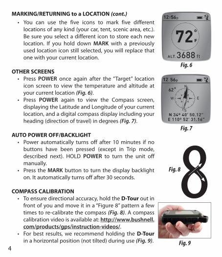
OTHER SCREENS• Press POWER once again after the“Target” location
icon screen to view the temperature and altitude atyourcurrentlocation(Fig. 6).
• Press POWER again to view the Compass screen,displayingtheLatitudeandLongitudeofyourcurrentlocation,andadigitalcompassdisplayincludingyourheading(directionoftravel)indegrees(Fig. 7).
AUTO POWER OFF/BACKLIGHT• Power automatically turns off after 10minutes if no
buttons have been pressed (except in Trip mode,described next). HOLD POWER to turn the unit offmanually.
• Press theMARKbuttonto turn thedisplaybacklighton.Itautomaticallyturnsoffafter30seconds.
COMPASS CALIBRATION• Toensuredirectionalaccuracy,holdtheD-Touroutin
frontofyouandmoveitina“Figure8”patternafewtimestore-calibratethecompass(Fig. 8).Acompasscalibrationvideoisavailableat:http://www.bushnell.com/products/gps/instruction-videos/.
• Forbest results,we recommendholding theD-Tourinahorizontalposition(nottilted)duringuse(Fig. 9).
MARKING/RETURNING to a LOCATION (cont.)
Fig. 9

5
RECORDING A NEW TRIP (ROUTE)• Press TRIP (3) to enter Trip mode. HOLD the TRIP
button to start recordingnewtripdata.Thedisplayshows a moving “hiker” icon, along with updatedreadouts of elapsed distance and average speedduringyourtrip(Fig. 10).
• To stop recording the trip data, HOLD the TRIPbuttonagain.
• The D-Tour automatically saves the data it collectsbetweenthetimeyoustartandstoprecordingyourtrip, including the date and time of the trip, totaldistance traveled,youraveragespeed,andchangesinaltitudeandtemperature.
• Press the TRIP button to view the distance andaveragespeedofyourlasttrip,alongwitharemainingmemory indicator (% of trip data memory used) (Fig. 11).TheD-Tourcanstoreupto24hoursoftotaltripdata(canbemultipletripsondifferentdays).
VIEWING TRIP DATAAfterrecordingatleastonetrip,connectingtheD-Tourtoyourcomputerwillenableyoutosee thepathyoutookonanyof4typesofmap,viewatripdatagraph,andshareyourtripviaemailorsocialmedia.Togetthesoftware:
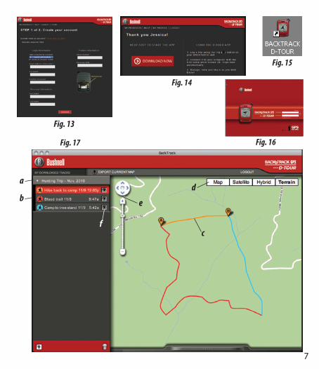
• Go to http://backtrackdtour.com/ and follow thedirections to create an account (free) and registeryourD-Tour,anddownloadthesoftwareapp(Fig. 13, next pg.). Your account provides online backup forall your tripdata. (Serial number is inside the battery compartment-(Fig. 12)). After registering, you’ll betakentoascreentodownloadtheD-Tourapplication(Fig. 14) (Adobe Air® is required-it will be installed automatically if you do not already have it on your computer).Click“DownloadNow”,thenselect“Open”.
Fig. 11
Fig. 12
Fig. 10

6
A link todownloadthesoftwarewillalsobeprovided inyourconfirmationemail.TurnontheD-Tourandconnect itsUSBport toyourcomputerwiththesuppliedUSBcable.OnWindows®PCs,theappshouldopenautomatically(ifnot,clickthedesktopicon(Fig. 15)).Note: if you get a Windows “AutoPlay” popup when you connect your D-Tour, click “Open Folder to View Files”, then double click a .btk (trip data) file). OnMac®,doubleclick the“D-Tour” icon inyourApplicationsfoldertolaunchtheapplication.
• EntertheUserName(emailaddress)andPasswordyouusedwhensettingupyouraccount,thenselect“LOGIN”(Fig. 16).Thiswillenableallyourtripdatatobestoredwithinyouronlineaccount,soitwillbeautomaticallybackedup,andaccessibletoyoufromanycomputer.
USING THE D-TOUR APP (Fig. 17)• After theD-Tour app opens, youwill see one ormore gray folders on the
left(a)below“MyDownloadedTracks”,eachlabeledwithadate.Eachfoldercontainsinformationonthetripstakenina24hourperiod.
• Clickthefoldertoopenitandviewtheindividualtrips(b)youmadeonthatdate (the duration of each trip is based on the time elapsed between thestartingandstoppingofanewtriprecordingwhenyouhelddowntheTRIPbutton).
• Therouteyoutraveledforeachtripisshownasacoloredline(c)onamap.Four types of maps are available-click on the name of a map type (d) tochangetheview:
MAP-a“roadmap”styleview,completewithroadnames.SATELLITE-anaerialphotoofthearea.HYBRID-acombinationofthefirsttwomaps.TERRAIN-thisisatopographicmapshowingelevationdataforthearea.
• Thezoomsliderandpositionarrowpadallowyoutozoomin/outandmovearoundonthemap(e).
• Clickonthenameofatriptohighlightitonthemap.Youcanhideanytripbyclickingonthe“eye”iconnexttoit’sname(f).
• To change the name of a folder (from the default date to something like
VIEWING TRIP DATA (cont.)
7
a
b
c
d
f
e
Fig. 13
Fig. 17 Fig. 16
Fig. 15
Fig. 14

8
“CanyonTripDay1”),rightclickonitsname.Youcanalsorightclickonatripwithinthefoldertorenameit.
USING THE D-TOUR APP (Fig. 18)• Clickingonthe“handle”(g)atthebottomcenterofthemapscreenwillopen
apopupgraphdisplayingthealtitude,temperatureandspeeddatafromthetrip.Youcanusethepull-downs(h)tochangehowthedataisdisplayed.Thisfeatureisidealforrunnersandbikersthatwanttotracktheirperformanceonanexercisecourseovertime.
• Tocreateanewfolder,clicktheplus(+)icononthebottomleft(i).Existingtripscanbedraggedfromtheiroriginalfolderintothenewone.
• Todeleteatriportripsfolder,dragittothetrashicon(j).• If you’d like to share thedetailsof your trips,we’vemade it easy. Just click
“ExportCurrentMap”(k)andselectasaveorshareoption.• The“SaveAs”optionallowsyouexportthecurrentmapviewasa.jpgphoto.• When you have finished using the D-Tour application, you don’t need to
logout, justclosetheapplication(l).Yourtripdata isautomaticallysavedinyouraccount.
USING THE D-TOUR APP ON OTHER COMPUTERSIfyouwanttoaccessyourD-Tourtripinformationfromanothercomputer,itisnotnecessaryforyoutocreateanewaccount.Simplylogintoyouraccountathttp://backtrackdtour.comclickonthedownloadlink,andinstalltheapp.
LOGIN/CHANGE PASSWORD If you logoutof theD-Tour application, youwill beprompted to log in againthe next time you launch the application. If you forget your password orwanttochangeit,youmayclickonthe“ForgotPassword?”linkontheapplicationloginscreen(Fig. 19). Youmayalsochangeyourpasswordafter loggingintoyourexistingaccountathttp://backtrackdtour.com/.Click“MyProfile”inthemenuatthetopofthescreen(Fig. 20).
Please read the Google™ Maps Terms of Service at: http://maps.google.com/intl/en/help/terms_maps.html

9
g
i j
k l
h
Fig. 18
Fig. 20Fig. 19

ONE YEAR LIMITED WARRANTY
YourBushnell®BackTrack™D-Tour™GPSunitiswarrantedtobefreeofdefectsinmaterialsandworkmanship foroneyear after thedateofpurchase. In theeventof adefectunderthiswarranty,wewill,atouroption,repairorreplacetheproduct,providedthatyoureturnthe product postage prepaid. This warranty does not cover damages caused by misuse,improperhandling,installation,ormaintenanceprovidedbysomeoneotherthanaBushnellAuthorizedServiceDepartment.
Any return made under this warranty must be accompanied by the items listed below:1)Acheck/moneyorderintheamountof$10.00tocoverthecostofpostageandhandling2)Nameandaddressforproductreturn3)Anexplanationofthedefect4)ProofofDatePurchased5)Productshouldbewellpackedinasturdyoutsideshippingcarton,topreventdamageintransit,withreturnpostageprepaidtotheaddresslistedbelow:
IN U.S.A. Send To: IN CANADA Send To:BushnellOutdoorProducts BushnellOutdoorProductsAttn.:Repairs Attn.:Repairs9200Cody 25AEastPearceStreet,Unit1OverlandPark,Kansas66214 RichmondHill,OntarioL4B2M9
ForproductspurchasedoutsidetheUnitedStatesorCanadapleasecontactyourlocaldealerforapplicablewarrantyinformation.
In Europe you may also contact Bushnell at:BushnellGermanyGmbHEuropeanServiceCentreMathias-Brüggen-Str.80D-50827KölnGERMANYTel:+49221995568-0Fax:+49221995568-20
Thiswarrantygivesyouspecificlegalrights.Youmayhaveotherrightswhichvaryfromcountrytocountry.
©2011BushnellOutdoorProducts

Warnings and Notices
GPS System & Location Accuracy Notice:TheGlobalPositioningSystem(GPS)isoperatedbythegovernmentoftheUnitedStates,whichissolelyresponsibleforitsaccuracyandmaintenance.ThesystemissubjecttochangeswhichcouldaffecttheaccuracyandperformanceofallGPSequipment.TheinherentnatureoftheGPSsystemitselflimitstheaccuracyofthedistanceindicatedontheunit’sdisplaytowithinabout±3~5meters(oryards)oftheactualmarkedlocation.
Warning:Thisdeviceisintendedasasupplementalhandheldnavigationaideonly.Theuserassumesallresponsibilityassociatedwiththeuseofthisproduct.Itmustnotbeusedforanypurposerequiringprecisemeasurementoflocation,direction,distance,velocityortopography.Thisdeviceshouldnotbeusedforanyaircraftnavigationapplications.
Vehicular Use Notice:Bushnelliscommittedtothesafeandresponsibleenjoymentoftheoutdoors.Donotusethisproductwhiledriving.Anaccidentcanresult inpropertydamage, injuryordeathiftheoperatorfailstopracticeprudentdrivingpractices.Itisthesoleresponsibilityofthedriverofanyvehicletooperatethemotorvehicleinasafemanner.InformationfromtheGPSunitcandistracttheoperatorofamotorvehicle.ItisunsafetooperatethecontrolsoftheGPSunitwhileoperatingamotorvehicle.Ifusedinamotorvehicle,itmustnotbeusedbytheoperatorofthemotorvehicle.Ifitisusedinamotorvehicleitmustbemountedinamannersuchthatitdoesnotdistracttheoperator,doesnotinterferewiththeoperator’sfieldofview,anddoesnotblockorinterferewiththeairbagsorothersafetymechanismsofthemotorvehicle.Windshieldsandcarwindowswithintegratedmetallicmaterials,suchasdefrosters,orcarwindowtintingfilms,candegradeGPSreceptioninsideacar.
Liability Notice:InnoeventshallBushnellbeliableforanyincidental,special,indirectorconsequentialdamages,whetherresultingfromtheuse,misuse,orinabilitytousethisproductorfromdefectsintheproduct.Somestatesdonotallowtheexclusionofincidentalorconsequentialdamages,sotheabovelimitationsmaynotapplytoyou.
FCC Note:ThisequipmenthasbeentestedandfoundtocomplywiththelimitsforaClassBdigitaldevice,pursuanttoPart15oftheFCCRules.Theselimitsaredesignedtoprovidereasonableprotectionagainstharmfulinterferenceinaresidentialinstallation.Thisequipmentgenerates,usesandcanradiateradio frequencyenergyand, ifnot installedandused inaccordancewiththe instructions,maycauseharmfulinterferencetoradiocommunications.However,thereisnoguaranteethatinterferencewillnotoccurinaparticularinstallation.Ifthisequipmentdoescauseharmfulinterferencetoradioortelevisionreception,whichcanbedeterminedbyturningtheequipmentoffandon,theuserisencouragedtotrytocorrecttheinterferencebyoneormoreofthefollowingmeasures:
·Reorientorrelocatethereceivingantenna.·Increasetheseparationbetweentheequipmentandreceiver.·Connecttheequipmentintoanoutletonacircuitdifferentfromthattowhichthereceiverisconnected.·Consultthedealeroranexperiencedradio/TVtechnicianforhelp.
ShieldedinterfacecablemustbeusedwiththeequipmentinordertocomplywiththelimitsforadigitaldevicepursuanttoSubpartBofPart15ofFCCRules.
Adobe®,Air®, Copyright © 2011 Adobe Systems Incorporated. All rights reserved. Google™ Maps Copyright © 2011 Google.Windows® Copyright © 2011 Microsoft. Windows® is a registered trademark of Microsoft Corporation in the United States and other countries. All rights reserved.Mac®, Copyright © 2011 Apple Inc. Mac® is a registered trademark of Apple Inc. in the United States and other countries. All rights reserved. Third-party marks and brands are the property of their respective owners. All products, dates, and figures are preliminary and subject to change without notice.

Bushnell Outdoor Products9200 Cody, Overland Park, Kansas 66214
(800) 423-3537 • www.bushnell.com
©2011 Bushnell Outdoor Products