Institutional adaptation to climate change · Institutional adaptation to climate change: Flood...
39
Institutional adaptation to climate change: Flood responses at the municipal level in Norway Lars Otto Næss, Guri Bang, Siri Eriksen, Jonas Vevatne. CICERO, Centre for International Climate and Environmental Research - Oslo P.O.Box 1129 Blindern NO-0318 Oslo Norway December 2003 Tel: +47 22858750 Fax: +47 22858751 DO NOT CITE OR QUOTE Prepared for presentation at the Open Meeting of the Global Environmental Change Research Community, Montreal, Canada, 16-18 October, 2003 Submitted to Global Environmental Change 1
-
Upload
nguyenngoc -
Category
Documents
-
view
217 -
download
0
Transcript of Institutional adaptation to climate change · Institutional adaptation to climate change: Flood...
Institutional adaptation to climate change:
Flood responses at the municipal level in Norway
Lars Otto Næss, Guri Bang, Siri Eriksen, Jonas Vevatne.
CICERO, Centre for International Climate and Environmental Research - Oslo
P.O.Box 1129 Blindern
NO-0318 Oslo
Norway
December 2003
Tel: +47 22858750
Fax: +47 22858751
DO NOT CITE OR QUOTE
Prepared for presentation at the Open Meeting of the Global Environmental Change Research Community, Montreal, Canada, 16-18 October, 2003
Submitted to Global Environmental Change
1
Do not cite or quote
Abstract
This article examines the role institutions play in climate adaptation in Norway.
Empirical findings from an examination of responses to the 1995 floods in two
municipalities in the Glomma-Lågen river basin, Eastern Norway, are presented. We
identify institutional factors that affect the adaptation potential at the local level, and
factors that serve to constrain or facilitate the realisation of this potential. The study
suggests that institutions provide important insights for understanding local
responses to climate change as well as for designing future strategies for adaptation.
Keywords (max six): Climate change, Adaptation, Floods, Institutions, Norway
Acknowledgements:
We would like to thank Tora Skodvin, Sjur Kasa, Lynn P. Nygaard, Kyrre Groven,
Carlo Aall, Lars Roald and Are Mobæk for useful comments on earlier drafts. The
study was carried out as part of a larger project funded by the Norwegian Research
Council. The project involves collaborative studies on institutional aspects of
climate change with Western Norway Research Institute and ProSus (Program for
Research and Documentation for a Sustainable Society).
Article title abbreviated appropriately for use as running headline
Inst. Adapt. Norway
2

Do not cite or quote
1 Introduction
Adaptation is increasingly seen as a necessary complement to greenhouse gas
mitigation measures (Smit et al., 2001). Human-induced climate change is likely to
present new, and to a large extent, unpredictable challenges to societies. This is of
particular concern at a local level – first because scenario uncertainties are highest
here, but also because studies of past climate-induced natural disasters (Quarantelli,
1987; Blaikie et al., 1994; Morrow, 1999), as well as long term climate change
(Liverman, 2002; O’Brien et al. in press) show that vulnerability and its causes are
location-specific. There is increasing attention paid to the need for a place-based
understanding of vulnerability, as a large proportion of decisions regarding climate-
induced hazards are local (Cutter, 1993; 2003). However, local decisions are shaped
by interactions at the local level as well as interactions with structures at higher
geographical scales that may mandate, encourage and inform actions (Wilbanks and
Kates, 1999).
Norway displays characteristics that make it instructive in a European
context. Its assumed adaptive capacity is high, based on indicators such as economic
resources, technology, information and skills, and infrastructure (O’Brien et al., in
press). At the same time, high adaptive capacity does not automatically lead to
successful adaptation (Yohe and Tol, 2002; Smit et al., 2001; Burton et al., 2002).
Furthermore, there are significant geographic differences within Norway in terms of
adaptation context as well as records of failures in adaptation (Lisø et al., 2003). An
emerging challenge is therefore identifying how resources underpinning adaptive
capacity can be translated into actions that reduce the societal vulnerability to
climate and other stressors.
3

Do not cite or quote
In this article, we analyse factors that constrain or facilitate the ability of
local level institutions in Norway to carry out adaptation measures. Specifically, we
examine measures taken in Skedsmo and Ringebu municipalities after the 1995
floods in Southeastern Norway. The 1995 floods were in some areas the largest in
200 years. They led to evacuation of 7000 people and caused damages equivalent to
NOK 1.8 billion. We examine how interactions between institutions at municipal
level and other geographical and managerial levels, particularly the national level,
shaped the measures that were carried out. We focus on how social learning1 and
conflicts of interests constrained or facilitated the institutional capacity to carry out
adaptation measures. We look at the institutional factors that shaped decisions
regarding the use of flood-prone areas, and in particular how institutional interaction
across scales influenced decision outcomes.
An increasing body of literature, including work focusing on the role of
social capital in vulnerability and resilience (Adger, 2000b), suggests that
institutional factors are crucial in determining adaptation (Adger, 2000a; Bakker,
1999; The Heinz Center, 2002; Tol et al., 2003). Institutions affect the social
distribution of vulnerability, as well as determine the management of climate-
sensitive aspects of society and, in turn, the capacity to adapt successfully. The focus
of this study is institutions connected to the formal municipal administration in
Norway and their capacity to make decisions that reduce local vulnerability to future
floods.
Findings in Ringebu and Skedsmo municipalities suggest that the current
institutional set-up favours technical solutions to flood management, and that this
bias has implications for vulnerability to future climate change. A more
comprehensive approach incorporating social and environmental aspects is therefore
4

Do not cite or quote
called for. We suggest that flexibility and a high capacity for institutionalizing past
experiences through learning might facilitate adaptation at the local level under
changing climatic conditions.
2 Framework for institutional analysis
2.1 Study design
Experiences from past climatic events may provide useful insights into the
constraints and barriers to adaptation to future climate change, especially since
climatic events have been found to trigger significant institutional changes (Miller et
al., 1997). A local-level approach to historical extreme events provides empirical
data that may hold important lessons for the future (Smit et al., 2001). Temporal
analogues, described by Glantz (1989) and other authors, involve investigating the
effects of past climatic events, emphasising processes of response more than the
precise nature of the event itself. Applying an analogue approach, we analyse
specific institutional aspects of responses to the 1995 floods in two municipalities in
the Glomma-Lågen river basin, Southeastern Norway.
A case study approach was chosen because of its suitability in explaining
current phenomena where one has little control over the events, and where one seeks
answers to questions of how and why (Yin, 1994). It has been argued that human-
environmental interaction in global change can be most effectively studied by
focusing on particular events (Vayda and Walters, 1999). The complexity of
relations among the social, environmental and economic processes that drive global
change, as well as consequences of such change, can best be understood by ‘careful
locality-specific research’. Although case-specific research can be difficult to
5

Do not cite or quote
generalize, comparative studies using case studies as ‘natural experiments’ can
facilitate theory-building (Wilbanks and Kates, 1999). By comparing two
municipalities, Skedsmo and Ringebu, constraints and barriers to local adaptation
that are unique to the local context and constraints borne out from institutional
structures and processes can be distinguished.
Wilbanks (2002) argues that climate change studies should pay attention to
processes operating at several scales. A focus on a single geographical scale can
frame an investigation too narrowly on issues, processes, data and theories
associated with that scale. We define our investigation to the scale of decision-
making unit as recommended by Cash and Moser (2000), but incorporate
information from multiple scales by examining the interactions with other decision-
making institutions that affect policy outcome.
The Glomma and Lågen river basin, located in the Southeastern part of
Norway (See Figure 1), has been exposed to a number of large floods over the past
centuries. Major floods occurred in 1789 (“Storofsen”), 1860, 1927, 1967 and 1995
(Eikenæs, Njøs et al. 2000). The severity of the floods of 1995 was due partly to
high snow accumulation levels in the spring, but more importantly the late onset of
the snow melting (end of May) combined with rapid temperature increases and
sudden heavy rainfall (Eikenæs et al., 2000; Roald, 2002). The resulting sharp
increase in water levels triggered widespread soil erosion and river sediment
transport, in turn causing considerable damages to roads and railways, buildings,
technical installations, and farmland (Brænne, 1995; Hindar et al., 1996; NIVA,
1996; NOU, 1996; Øygarden et al., 1996; Eikenæs et al., 2000). The floods had an
overall return period of 100-200 years; in parts of the river basin it was the biggest
since the great floods of 1789 (Skurdal et al., 2000). One person was killed and 7000
6
Do not cite or quote
had to be evacuated from their homes (Lundquist et al., 1996). Costs of flood
damages were estimated at a total of NOK 1.8 billion, of which NOK 1 billion was
covered by private insurance and NOK 0.8 billion by government funds (NOU,
1996).
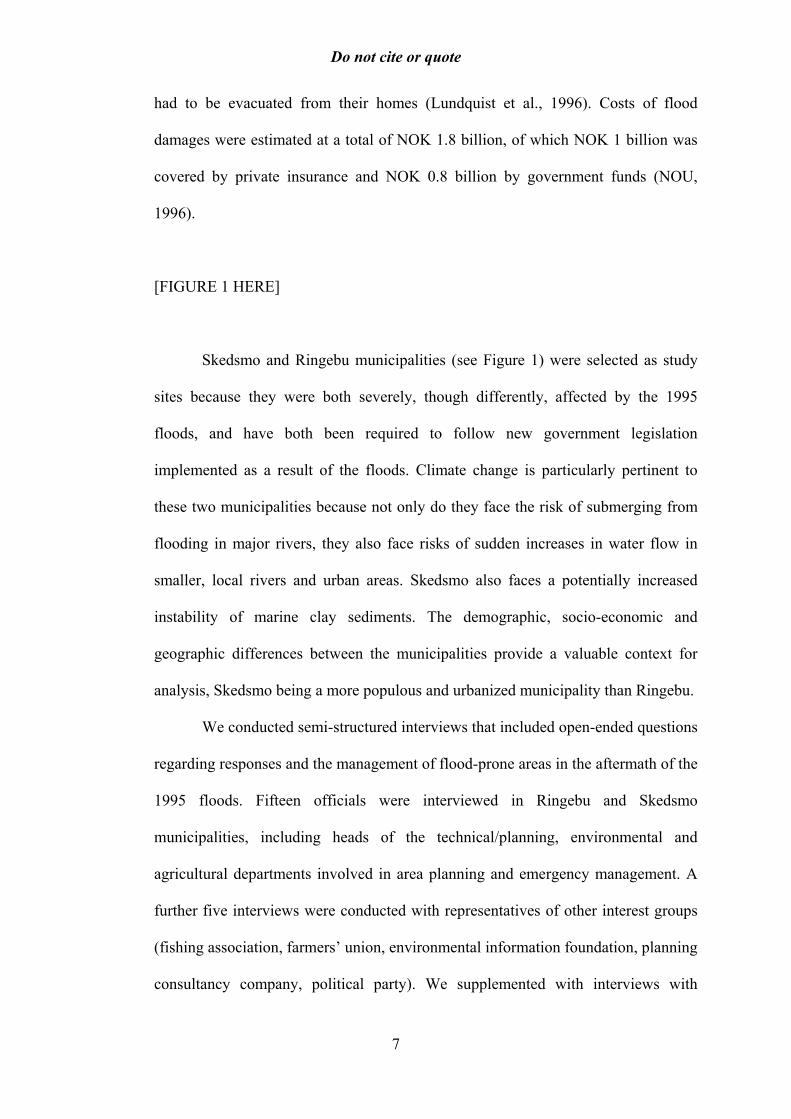
[FIGURE 1 HERE]
Skedsmo and Ringebu municipalities (see Figure 1) were selected as study
sites because they were both severely, though differently, affected by the 1995
floods, and have both been required to follow new government legislation
implemented as a result of the floods. Climate change is particularly pertinent to
these two municipalities because not only do they face the risk of submerging from
flooding in major rivers, they also face risks of sudden increases in water flow in
smaller, local rivers and urban areas. Skedsmo also faces a potentially increased
instability of marine clay sediments. The demographic, socio-economic and
geographic differences between the municipalities provide a valuable context for
analysis, Skedsmo being a more populous and urbanized municipality than Ringebu.
We conducted semi-structured interviews that included open-ended questions
regarding responses and the management of flood-prone areas in the aftermath of the
1995 floods. Fifteen officials were interviewed in Ringebu and Skedsmo
municipalities, including heads of the technical/planning, environmental and
agricultural departments involved in area planning and emergency management. A
further five interviews were conducted with representatives of other interest groups
(fishing association, farmers’ union, environmental information foundation, planning
consultancy company, political party). We supplemented with interviews with
7

Do not cite or quote
regional and national level officials in water resources- and emergency management
institutions. Secondary information regarding the 1995 floods was reviewed,
together with recent literature regarding institutions, regulations and adaptation to
climate change, presented in Næss (forthcoming).
2.1.1 Ringebu
Ringebu is located in the Gudbrandsdal valley, Oppland County. The municipality
has 4644 inhabitants (as of 1 January 2003) and covers an area of 1250 km2, 60% of
which is above 900 m.a.s.l.2 The population has decreased slightly over the past
decade. The largest recorded floods in Ringebu are the great floods of 1789 (“Stor-
Ofsen”). In normal years, there are two largely unproblematic floods in Ringebu,
following snow melting in the catchments of, respectively, the rivers of Lågen and
Otta. A number of flood defences have been built along the Lågen River to
straighten and stabilize the river, thus preventing damage to properties and
agricultural areas. A new highway has been built on the river plain in the Southern
part of the municipality near Fåvang, also acting as a flood dike.
2.1.2 Skedsmo
Skedsmo Municipality is situated northeast of Oslo, in Akershus County. It covers
77 km2 and has 40 676 inhabitants (as of 1 January 2003), 95% of whom live in
urban or semi-urban areas. The population is steadily increasing and the municipal
administration estimates a need for 3-500 new housing units per year in the near
future. Floods in Skedsmo have traditionally been governed by its proximity to Lake
Øyeren and the three main rivers discharging into it, Nitelva, Leira and Glomma.
Apart from the great flood of 1789, major flood years include 1860, 1863, 1867,
8
Do not cite or quote
1890, 1895, 1910, 1916, 1927, 1934, 1966, 1967 and 1995. An important bottleneck
has been the outlet at Mørkfoss. The width of the riverbed at Mørkfoss was widened
in 1860 and after the floods in 1967. Skedsmo also experienced rain-induced floods
in 1997 and 2000.
2.2 Research questions
Institutions are systems of rules, decision-making procedures, and programs that
give rise to social practices, assign roles to the participants in these practices, and
guide interactions among the occupants of the relevant roles (Young, 1998). They
arise in all areas of human endeavour and can be either formal or informal.
In the context of this study, however, we focus on formal institutions at the
municipal level taking part in decision making processes concerning use of flood
prone areas, and how they interact with institutions at county and national level. We
discuss the way decisions are shaped by the interplay between institutions, and
furthermore how new experiences, information and social learning, as well as
power-constellations and interest conflicts affect the potential for adaptation for
local-level institutions. Key roles of institutions at the national and municipal level
are described in more detail in Table 1. Our investigation focuses on the institutions
relevant to management of flood prone areas, in particular area planning and water
resources management institutions.
[TABLE 1 HERE]
A better understanding of how institutions shape flood management may be
useful in a climate change perspective for several reasons. Climate change may put
9

Do not cite or quote
new demands on existing institutions, either through aggravating current flood
problems or through creating new situations and new types of problems, floods in
different parts of the year, and new types of floods (Miller et al., 1997; Tol et al.,
2003; Brown and Damery, 2002). The ability (both economically and logistically) of
a local community to carry out measures to reduce the risk of negative effects from
future similar climatic-induced events may be closely related to the capacity of
municipal institutions to prepare for climate change in future. In other words, the
degree to which municipal institutions are prepared and flexible in terms of handling
the unexpected might be a determining factor for the municipality’s responsive
capacity.
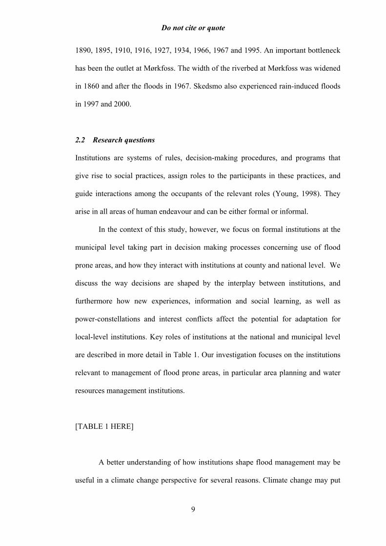
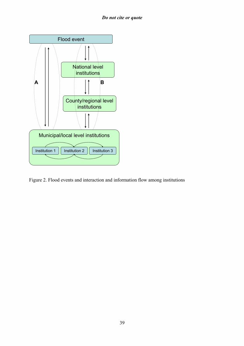
[FIGURE 2 HERE]
Figure 2 illustrates that decisions at the municipal level aimed at flood management
may be either made directly in response to a severe flood event (pathway “A” in the
figure), or made as a response to national level decisions that affect the framework
of decision making at the municipal level (pathway “B”). The arrows indicate flows
of information and influence: first that floods trigger responses, and further that
there exist, through formal and informal channels, two-way information and
influence pathways among institutions at different levels.3
The overriding question of interest in this study is to what degree municipal
institutions are appropriate instances for responding to climate change adaptation
issues such as flooding. To address this general question, we have formulated three
more specific research questions.
10
Do not cite or quote
First, the interaction between different interest groups in the municipality, as
well as potential conflicts of interests both between actors within the municipal level
and between the municipal and regional and national levels may constitute barriers
and constraints to adaptation. For instance, there may be a conflict between
economic and environmental interests regarding the shaping of a particular
adaptation measure. Differences in interests between actors in the local community
may lead to conflict over what kind of actions should take priority or how to shape a
particular adaptation measure. The objectives of a measure serve different interest
groups in the municipality. For example, if flood protection is built around vital
agricultural land, but at the same time is used as the main road through the
municipality, uncertainty arises as to the main objective of the flood wall: protection
of agricultural land, or providing a new and better road? Also, differences in
interests between municipal, county and national institutions may affect decision-
making about local area planning, for instance where county or national institutions
have power in decision-making processes (pathway B in Figure 2) that override the
municipal administration. Thus the first research question is to what degree conflicts
of interest have constrained the potential for adaptation and shaped the types of
measures that have been enacted.
Second, municipal institutions represent a potential for storing and passing
on relevant knowledge from actions taken during previous extreme events (Pathway
A in Figure 2). This institutionalisation of social learning could potentially alleviate
the transition to a changed flood pattern resulting from climate change. In particular,
specialized institutionalised knowledge about the local context could be valuable.
However, social learning may also be a slow process, where established
organizations and actors in the decision-making process, for instance on local area
11

Do not cite or quote
planning, may resist changes in structures and practices. Such resistance to change
may affect local ability to adapt to climate change. An institutional set-up
appropriate to the present climate may not be effective when faced with changing
climatic conditions unless it exhibits flexibility and the ability to institutionalise new
knowledge. While specialized knowledge held by specific experienced individuals
may be instrumental in achieving successful adaptation, the real question is to what
degree this knowledge can be successfully transferred to the institution – that is, to
what degree the society as a whole can “learn” from the experiences of its
individuals (Olsson and Folke 2001). Thus our second research question is to what
degree social learning has facilitated adaptation and shaped the types of measures
that have been enacted.
Third, learning from a flood event also takes place indirectly through
national level responses and generation of information (Pathway B in Figure 2). In
the aftermath of the 1995 floods, a government commission on flood protection
(Flomtiltaksutvalget) was established to look into experiences from the floods and
what could be done to prevent similar damages in the future (White Paper no. 37,
1995-96 and no. 42, 1996-1997; NOU, 1996). The HYDRA research project (1997-
2000) was initiated to improve the knowledge base on floods and give
recommendations for policy measures to prevent and mitigate future floods. Several
assessments of flood impacts on agricultural lands, technical installations, water
quality, socio-economic systems, and ecosystems were carried out (Brænne, 1995;
Hindar et al., 1996; NIVA, 1996; NOU, 1996; Øygarden et al., 1996; Eikenæs et al.,
2000). From 1998, flood zone maps were developed by the Norwegian Water
Resources and Energy Administration (NVE) and were intended for use by
municipalities to identify areas of high flood risk and needs for flood protection
12

Do not cite or quote
measures. New standards for building in flood-prone areas, including regulations on
area planning in risky areas and guidelines on the use of flood-prone areas were
developed (NVE, 1999; Ministry of Environment and Ministry of Municipal and
Local Governments, 1997). Early warning systems were also strengthened,
especially the risk and vulnerability analysis in municipalities. However, the
receptiveness and incorporation of national responses to a flood, nationally
generated information and guidelines, as well as regulations at the local level
(Pathway B in Figure 2) may not always be smooth, nor may local experiences from
a flood feed back effectively into national level knowledge systems. Thus the third
main research question is how the interaction across scales affected adaptation and
shaped the types of measures enacted at the municipal level.
3 Case study: the 1995 flood and responses
3.1 The 1995 floods in Ringebu and Skedsmo
The 1995 floods demonstrated that both Ringebu and Skedsmo are vulnerable to
climatic extremes, in terms of both economic and social impacts. In Ringebu, the
two main population centres are located on old river deltas of tributaries to Lågen
River, Tromsa and Våla. These tributaries caused the main economic damages in
Ringebu during the 1995 floods as they carried large amounts of stone and gravel
from the mountains, depositing them in the lowlands. Concern over damage to the
water supply pumps (and hence pollution of the drinking water) prompted a
temporary closure of the drinking water supply to private homes. Other economic
damages included loss of agricultural harvest on the floodplain, damages to forest
13

Do not cite or quote
feeder roads and bridges, and damages to buildings at the Winter Olympic arena at
Kvitfjell. Total flood damage costs in Ringebu were estimated to NOK 21 million.
The main road through the valley (E6) was submerged. The railroad was closed, and
the township of Ringebu was effectively isolated for a period during the flood peak.
Similarly, large areas of Skedsmo municipality, including parts of the town,
Lillestrøm, were flooded in 1995. A large share of the population in Lillestrøm had
to be evacuated during the floods.
The emergency responses in both municipalities demonstrated a high degree
of coordination between institutions at different levels, including relevant offices in
the municipality administration, the regional waterworks, fire departments, the Civil
Defence authorities, as well as NVE and the county administration. Following rapid
increases in water levels and warnings from the Glomma and Laagen Waterworks
Cooperative (GLB) and NVE on an impending major flood, each municipality
established an emergency council, formally led by the Mayor.
Emergency preparedness limited some of the damages in Skedsmo. The flood
warning reached the municipality on 25 May 1995, and gave the authorities time to
prepare. Furthermore, a flood emergency plan set up after the flood in 1967 had been
reviewed as a matter of routine during late April/early May 1995. Measures
implemented after the flood warning arrived included closing manholes and drains,
the latter to avoid clogging of the drainage system given its limited ability to deal
with large and sudden inflows of rainwater. A (temporary) flood dike was built
along the river Leira, and a temporary flood protection wall was set up through the
township of Lillestrøm, where a large share of the population had to be evacuated
during the floods.
Water levels in Lake Øyeren peaked on 8 June 1995 at 2.22 metres below the
14
Do not cite or quote
recorded peak water levels in 1967. It is estimated that peak levels were lowered by
2 metres due to regulations upstream from Lake Øyeren in the Glomma and Lågen
rivers and another 2 metres due to greater capacity at the outlet out of Lake Øyeren,
i.e. a total of 4 metres.
3.2 Municipal responses to the 1995 floods
3.2.1 The impact of conflict of interests on policy outcome and climate adaptation
We found that in both municipalities, technical measures were a dominant decision
outcome in vulnerability reduction, often favouring economic interests at the
expense of environmental interests. The technical bias was particularly strong where
there was consensus between municipal, county, and national level institutions. In
both municipalities, there was general agreement between different departments
within the municipality that several technical improvements had to be made to
infrastructure in order to prevent similar future impacts. Many of these
improvements corresponded to the information and priorities outlined by national
level assessments of flood impacts and the government flood commission (NOU,
1996). Following the floods, technical installations for drinking water, electrical
supply, bridges, and roads in Ringebu were repaired and elevated to above the peak
water level to ensure safety during similar flood events in the future. A map showing
peak water levels during the flood4 was used by the municipal planning office.
Skedsmo demonstrated a general consensus for major, expensive technical
measures in response to the 1995 floods. A permanent flood dike was built around
Lillestrøm township after the municipal government made a unanimous decision in
favour of it on 30 August 1995, less than two weeks before the local elections. The
flood dike was built at 106.5 metres above sea level, compared to the standard level
15

Do not cite or quote
of 101.6, at a total cost of NOK 74.3 million.5 The municipality and NVE both
contributed 27 million, the national Ministry of Defence contributed 1.6 million, and
Dyno industries (local firm) contributed NOK 0.5 million. Fifteen pumping stations
were constructed in connection with the dikes. A new emergency plan was prepared
in light of the new measures. It was estimated that Lillestrøm would now be secure
against 300-year floods (the 1995 floods peaked at a 200-year flood level). A flood
dike was also constructed near the village of Leirsund, where NVE covered all the
costs.
In Ringebu, most of the measures to reduce vulnerability after the 1995
floods were technical in nature, some leading to conflicts with fishing and
environmental interests. National institutions involved in environmental and
resource management interacted with the municipal Technical Department in
decision making regarding flood responses. Fishing and environmental interests
were critical of flood defence measures in the aftermath of the 1995 floods. Gravel
and stone were removed from the tributaries, particularly near the river mouths
where they had built up during the floods. A fishing association for the Lågen River
did not oppose the removal of sedimented material per se, but critisised the way the
sediment removal was implemented after the floods. Out of consideration for fish
spawning grounds, the County Environment Administration limited the amount of
gravel and stone proposed removed by the municipal Technical Department. The
fishing association nevertheless argued that removal of gravel and sediments after
the floods caused more damage to river fish stocks than the flood itself.
Conflicts of interest also arose in Skedsmo between environment
conservation on one hand and construction work on the other. The municipality
encompasses areas rich in biodiversity (Leira River and riverine landscape). These
16
Do not cite or quote
areas were affected by construction work during the 1990s in connection with a new
main airport for Oslo (Gardermoen), including an airport railway line. Interviewees
said the work had impacted on the annual river flood cycle, in that floods arrive
earlier and peak sooner than before. The areas along the river are also attractive for
developers. A golf course has been planned, but not yet approved for construction.
Similarly, conservation of natural ravine landscapes conflicts with housing
developments and forest management. Several residential areas in Skedsmo were
constructed in a ravine landscape and have proved susceptible to landslide during
extreme rain events. Measures to protect houses have been made. Feiring Bruk, a
local construction company, made an agreement with the municipality to fill in the
ravines and in return get the proceeds from sales of properties they have filled in.
Levelling of the ravine landscape was earlier supported by the government.
Furthermore, forest owners wish to level ravine areas to increase productivity, which
is in conflict with biodiversity conservation. Some areas have already been filled in.
The municipal environmental officer advocated a stronger conservation category for
the Leira River to prevent loss of the environmentally valuable ravine landscape.
3.2.2 The role of social learning in facilitating policy formation and climate adaptation
Flood responses in 1995 and incorporation of lessons learnt afterwards relied largely
on a few individuals’ in-depth knowledge and experience. This was particularly
evident in Ringebu, but also seemed to be the case in Skedsmo. Municipal
institutions deemed such knowledge critical for vulnerability reduction. At the same
time, there appeared to have been relatively little focus on formalising routines,
including handover of vital knowledge of key persons to new staff.
There were relatively few changes in formal routines for emergency
17

Do not cite or quote
management in Ringebu following the flood, for example. Interviewees raised
concerns that responses during floods were arbitrarily organised, lacking in
coordination and teamwork, with ad hoc and unclear allocation of responsibilities. A
recent rehearsal of emergency routines revealed many of the same shortcomings as
in 1995. Similarly, there appeared to be few if any formal changes in planning
routines in the municipality following the floods. The municipal master plan has not
been updated since 1993. While the map showing flood levels in 1995 was reported
to be in use during the first years following the floods, it did not appear to be in
active use today. With respect to flood defences, some interviewees expressed
concerns that sedimentation patterns had changed over the last few years, and that
this might be a result of technical interventions since 1995.
A dominant feature in the flood responses in the two municipalities was a
weak interplay between municipal, county, and national levels in terms of
information flow and learning. Interviewees in Ringebu, for example, expressed
scepticism towards NVE and other national depositories of information, describing it
as “too theoretical” and not showing enough interest in the concerns of the
municipality. While flood zone maps were considered useful, the municipal
administration focused less attention on flood warnings issued by NVE, as they were
deemed too general and often regarding events that were very small in the Ringebu
context as well as sometimes being issued too late. Emergency preparedness
involves policies and structures to avoid and mitigate risks for natural hazards such
as floods. The main instrument is formal laws and the main state institution is the
Directorate for Civil Protection and Emergency Planning (DSB), which is under the
authority of the Ministry of Justice and the Police. DSB has regional and local
offices which coordinate follow-up down to the municipality level. The
18

Do not cite or quote
collaboration with county and civil defence authorities appeared better with regard
to emergency management, especially with the latter in a coordination and
information role.
Interplay with national institutions in terms of information flow and
incorporating learning appears to have taken place to a larger extent in Skedsmo
than in Ringebu, both in terms of learning from the floods and improvement of
emergency routines. As a result of the higher levels of interaction and agreement
with national level institutions, NVE considers Skedsmo a good example of how
municipalities should respond.
3.2.3 The effect of institutional interaction across levels on policy formation and climate
adaptation
While institutional consensus across scales, particularly in the immediate aftermath
of the floods, in some cases contributed to the observed technical bias in
vulnerability reduction, there were also cases of diverging interests in municipal
decision making. Decisions in Ringebu regarding construction in risk-prone areas
were reached as compromises between economic interests (represented by municipal
institutions), and the priority of minimising future risk (represented in municipal and
national level institutions). In general, new construction was not allowed in areas
that were flooded in 1995. An exception was a gasoline station on the floodplains,
planned before the floods. Construction went ahead on the condition that the ground
was elevated to above the peak flood level in 1995, but concerns regarding safety
have been raised by NVE.6
Norwegian municipalities have the main responsibility for area planning
according to the Planning and Building Act of 1985. In case of disputes plans in
some cases have to be formally approved by the Ministry of the Environment. NVE
is responsible for channelling support for building of flood defence structures, as
well as giving advice on flood vulnerability. “The Guidelines for Building in Flood
19

Do not cite or quote
Prone Areas,” published by NVE, outline responsibilities of different actors. While
in some cases construction plans in flood prone areas have been stopped by national
level institutions, these institutions did not use their veto powers in the decision-
making process regarding the gasoline station in Ringebu, an example of economic
interests influencing flood-related decisions.
A case where a national institution did use its veto powers in decision
making is the Ringebu municipal plan from 2000 to eradicate mosquitoes through
draining and drying out wetland areas along the Lågen River. The municipality cited
public health concerns as the main reason for the plan, but also benefits of making
available more areas for agriculture and infrastructure. The County Governor
opposed the plan, as did the national Directorate for Nature Management, arguing
that the plan would lead to loss of biodiversity while pointing to uncertainty
surrounding the effectiveness of the plan. The issue went to the Ministry of the
Environment for a final decision. In August 2001, while on a visit during her
election campaign, the Minister of the Environment promised support to the
municipality, and finally approved the plan in October 2001.
The interaction between economic interests, municipal technical
considerations, and national level institutions also shaped decisions about area use in
Skedsmo after 1995. Municipal plans about building a shopping centre in an area
that was submerged by 1.3 meters during the 1995 floods were blocked by national
institutions, for example. At the same time, a residential area that was submerged
during the floods was expanded.
Interviewees at the municipal level in Skedsmo argued that, in hindsight, the
measures taken during and immediately after the floods were too complex. This was
caused by too high prognoses for water levels, and that the measures taken after the
20

Do not cite or quote
floods in 1967 were more effective than expected to meet the 1995 floods. Among
the costly measures that proved unnecessary were dismantling of the telephone
system in the town hall, and the electronic map databases. Overall, interviewees in
Skedsmo said that the emergency planning had improved since 1995. Recurrent
crises, including a gas leakage in 2000, have given the municipal administration
experience and contributed to improving routines for emergency management.
3.3 Institutional factors shaping adaptation in Ringebu and Skedsmo
Two main features of the flow of information and learning and interaction of
interests emerged as influencing municipal capacity to implement adaptation
measures.
3.3.1 Lack of knowledge transfer between national and local levels
Ringebu and Skedsmo exemplify how municipal institutions interact with
institutions at national and county levels to make decisions regarding vulnerability
reduction. We found weak interlinkages in terms of knowledge transfer, sometimes
perceived at the municipal level as top-down approaches of information generation
and dissemination. This may impede adaptation measures at local level.
As illustrated in Figure 2, municipal level institutions and their decisions are
linked to floods by two main routes. The first pathway (B) illustrates findings of
how the floods triggered national efforts to assess damages after the floods and
implement measures to avoid losses in future floods, such as increasing the
availability of information such as flood warnings and maps of flood prone areas.
Common for regulations and information services were that they were initiated from
21

Do not cite or quote
the national level and implemented through the county governor or regional offices
down to the municipalities, aiming to improve the local flood responses.
The other pathway (A) represents a direct response between floods and the
municipality level. In 1995, municipalities implemented preventive measures and
measures to restore damaged infrastructure. Examples include the decision to build a
flood dike in Skedsmo, and the use of a map showing maximum flood levels for
planning purposes in Ringebu. This “second route” is characterized by rapid
responses, local initiatives (within the rules, regulations and funding schemes
provided by the central government), supported by direct experience of flood
impacts and local knowledge. This direct linkage has received less attention in
national assessments, in terms of how decisions were formed at the local level, to
what extent initiatives based on local knowledge about floods were incorporated in
national level strategies, how adaptation decisions are formed in the local level
institutions, and what are the potential conflicts and synergies between these parallel
processes of response.
3.3.2 Technical bias
Both municipalities displayed a strong focus on technical flood defense. Flood
protection is traditionally the domain of technical departments, which is reflected in
a technical bias on proposed solutions such as building of dikes along rivers and
drainage of sediments. Within the municipal administration, flood problems were
also perceived as being caused by lack of technical protection schemes. Whereas the
level of technical flood protection schemes in the Glomma-Lågen river basin is
relatively low compared to other river basins in Norway and Europe, negative
effects of such measures on fisheries and environmental protection are already
apparent. One reason for the bias towards technical measures is likely to be an over-
22
Do not cite or quote
representation of technically oriented expertise in municipal administrations,
especially those departments concerned with flood management. It is reinforced by
the kind of information and guidelines received from national level institutions:
flood zone maps and guidelines for building and protection of infrastructure and
technical installations implicitly focus attention on technical protection measures. In
addition, construction of flood defences in Skedsmo, and draining of wetlands in
Ringebu, demonstrated how high-profile physical structures may more easily receive
national support (financially and politically) at politically opportune moments, such
as after a flood event or during an election campaign.
There is increasing evidence internationally that technically oriented flood
protection actually aggravates flood problems and also conflicts with the values of
stakeholders and citizens (Tol et al., 2003). There is increasing recognition within
NVE of the constraints a bias towards technical measures represents, and that rivers
need to be given “space.”7 Both Skedsmo and Ringebu demonstrate the risk of
“over-technification” where continued emphasis on technical solutions in municipal
administrations could become a barrier to optimal flood management and
vulnerability reduction. By treating flood adaptation as a one-off measure
(technically oriented flood-protection measures) rather than a continuing process
(incorporating new knowledge and climate change information, sometimes
generated at national levels), they may find themselves vulnerable to changing
weather patterns, such as increasing problems of intense rainfall events.
3.4 Is the municipality the appropriate level for decision making about
climate adaptation?
23

Do not cite or quote
The two case studies illustrate how social learning, conflicts of interest, and the way
in which these interact across scales have several implications for municipal
institutions as the appropriate level of adaptation.
The municipal level was subject to institutional factors that enhance and
constrain its capacity as the appropriate level of adaptation. First, the local context-
specific knowledge possessed by key individuals in municipal institutions was
regarded as important as a basis for making decisions at the local level. This
informal and in-depth knowledge of local conditions pertinent to flood risk was
unique to the municipal or local level. Such knowledge may have contributed to the
low numbers of lives lost (1) in the entire basin in 1995. However, municipal
institutions may be vulnerable to the loss of valuable response and adaptation
information due to a lack of institutionalisation and integration into formal systems.
Second, a bias towards immediate, one-off, technical measures was another
outcome of interaction across scales that limited municipal adaptation capacity.
Findings in Skedsmo suggested that measures were aimed at one particular climatic-
derived factor (floods) rather than preparing the community at large for climatic
variability in general. In addition, social adjustments and improvements in
information flow of a more ongoing and long-term in nature were to a large extent
ignored in both municipalities. There may be less attention paid to integrating local
knowledge about the environment into routines, for example.
The above findings have potentially important implications for equity.
Negotiation of interests that consistently results in technical interventions may
benefit some more than others. Economic interests influenced decision-making
towards construction of housing and businesses in flood-prone areas, along with
flood-protection structures. Interests that may stand to lose from decision making
24

Do not cite or quote
skewed towards technical measures include environmental interests where
environmental qualities of the land are lost and, indirectly, the taxpayers who
essentially pay for expensive measures. Technical measures may also simply ‘move’
a flood problem to other geographic areas or even create other environmental
problems, potentially influencing the vulnerability of other municipalities
negatively.
An important feature that emerged from the analysis was that some types of
measures involved in adaptation may be outside the scope of the municipal
institutions. First, holistic environmental management that might ensure greater
equity between interests in adaptation could involve action at a river basin or county
scale rather than the municipal scale. For example, some environmental interests
were better represented at county levels than at the municipal level. Second,
municipal institutions were limited by an increasing economic squeeze the causes of
which are largely beyond the sphere of influence of individual municipalities. One
of the main processes currently affecting municipal capacity is the devolution of
responsibilities from national to municipal level institutions. At the same time, the
financial framework within which these institutions operate is increasingly
constrained, putting decision makers in an economic squeeze. In addition, the
technical expertise may also be under stress, particularly in small municipalities,
such as Ringebu.8 Aall and Groven (2003) suggest that municipalities increasingly
have to prioritize the pressing problems, such as schools and social services.
Addressing other long-term issues such as preparing for future events or climatic
changes then becomes difficult, as costs are incurred now but short-term gains are
limited. This tendency may be reinforced by the perception that the government will
cover costs associated with major climate events with compensation schemes. The
25

Do not cite or quote
role of insurance in buffering costs has been observed by Teigland (2002) regarding
other extreme events in Norway.
What general lessons can be drawn from the above two cases regarding the
optimal level of adaptation? The findings suggest that while the local level is critical,
adaptation in terms of reducing vulnerability may require measures carried out at
several different scales. Addressing the above barriers to adaptation requires
measures that are beyond the scope of the municipal level alone. Climate change
adaptation measures targeted at enhancing local knowledge and the flow of
information between national and local levels may include interventions at the
national level. Furthermore, the technical bias of measures carried out at the
municipal level suggests reforms of municipal structures or processes to ensure that
a wider range of experts (including non-technical) and stakeholder interests be taken
into consideration. Some of the contributing causes to the technical and ‘one-off
measure’ approach to vulnerability reduction may be rooted in national processes,
however. Technical measures are partly facilitated by the largely technical
information received from the national level and the willingness of national
institutions to fund large-scale physical measures after a dramatic event.
4 Conclusions
This study investigated responses to reduce vulnerability in terms of decisions made
at the municipal level regarding flood-prone areas. These responses demonstrate
features of the way in which information flow and learning, and conflicts (or
convergence) of interests affect decision making and adaptive capacity. Main
features of the responses to the 1995 floods in Skedsmo and Ringebu include:
26

Do not cite or quote
• A bias towards technical aspects of flood management at the expense of social
and environmental aspects
• A lack of recognition of local knowledge in formal flood management, and
dependence on key knowledgeable persons
• Scepticism from the municipal level towards national level guidelines and
measures
This study does not provide a comprehensive review of the role of all
institutions, formal and informal, in adaptation to climate change. The investigated
interactions regarding, for example, social learning, provide a starting point for
understanding the capacity of institutions to reform in response to climate change.
These are issues that can be investigated in more detail. Another aspect of adaptation
to climate change is its integration in economic and social planning, a process which
was not specifically investigated but of which there are few if any known cases in
Norwegian municipalities. This is likely to be a crucial element in adaptation,
however.
While there are limits to the extent to which findings from two cases can be
generalised, the identified barriers and incentives to adaptation may be instructive to
local adaptation in general. Significantly, the general constraints in adaptation
carried out by formal institutions can provide lessons regarding geographic scales of
adaptation as well as interaction across scales. These lessons add to current
understanding of climate change adaptation, in particular regarding the local level as
the optimal scale of adaptation. The study confirms the proposition by Cutter (2003)
that appropriate measures demand local specific knowledge. However, institutional
factors may limit the municipal capacity to carry out appropriate measures. In
addition, there are adaptation measures that are outside the scope of the municipal
27

Do not cite or quote
level. The study focused on social learning, conflicts of interest and their interaction
across scales as institutional factors that may constrain or facilitate adaptation at the
local level. Our findings underscore the observations by Olsson and Folke (2001),
namely that co-management systems across scales can help increase the robustness
in the face of external changes. In particular, we suggest that the ability to make
decisions regarding the reduction of vulnerability is strongest when the linkages
outlined in Figure 2, between an extreme event, national responses and local
responses, reinforce each other. Interaction characterised by poor information flow
combined with poor institutionalisation of local knowledge, represents a potential
barrier to the development of effective adaptation measures. Another potential
constraint is lack of attention and integration of informal knowledge systems in the
formal flood response institutions, as shown in Figure 2.
The observed limits in tackling processes pertinent to adaptation that are
beyond the scope of the municipality underscores findings elsewhere in the world
regarding the causes of vulnerability. O’Brien and Leichenko (2000) argue that
multiple pressures, including large scale socio-economic processes such as economic
globalisation, shape vulnerability, in addition to climate change itself. In the context
of local adaptation, the process of devolution of responsibilities from the central to
municipal government may limit the financial and technical capacity of municipal
institutions to carry out measures aimed at long term adaptation.
The findings confirm the need to lift our eyes beyond the local level even if
the local is the topic of investigation, as suggested by Wilbanks (2002). Studying an
event in-depth while examining linkages at least partly meets this challenge. The
above framework can form the basis for future studies specifically on similar issues
in other municipalities in Norway, as well as adaptation more generally. The factors
28

Do not cite or quote
found to limit adaptation capacity in Ringebu and Skedsmo are likely to be no less
relevant to the capacity of other municipalities in Europe to carry out measures.
Many European countries have a lower degree of centralisation of management than
Norway, implying that the coordination of adaptation measures and the flow of
information between different municipalities and between institutions at different
geographic scales may be even more complex than observed here. In principle, the
new EU water directive aimed at enhancing basin-wide management of water
resources is a step in the right direction in terms of adaptation. The findings in this
study suggest that there are several potential challenges to its effective contribution
to adaptation, however. These challenges include the integration of local knowledge,
avoiding a flow of information and structures that are perceived as top-down, and
resistance to change.
Our study demonstrates that in order for the local level to realise its potential
as an optimal level of adaptation, flexibility of institutions and social learning are
important prerequisites. It is likely that these prerequisites can only be addressed in
combination with measures aimed at improving interplay and information flow
between the national and municipal level. Adaptation to climate change therefore
requires action both at the local and at the national level. In particular, identifying
ways that ‘direct’ response can reinforce information flows between the national,
county and municipal levels could contribute to strengthening decision making
regarding the reduction of vulnerability at municipal level.
29
Do not cite or quote
References
Aall, C. and Groven, K., 2003. Insitutional responses to climate change. Review of the contributions of four insitutional systems to climate change adaptation. (Institusjonell respons på klimaendringer. Gjennomgang av hvordan fire institusjonelle systemer kan bidra i arbeidet med å tilpasse samfunnet til klimaendringer.) Report 3/2003. Western Norway Research Institute, Sogndal. In Norwegian.
Adger, W. N. 2000a. Institutional Adaptation to Environmental Risk under the Transition in Vietnam. Annals of the Association of American Geographers 90(4): 738-758.
Adger, W. N., 2000b. Social and ecological resilience: are they related? Progress in Human Geography 24, 347-364.
Bakker, K., (ed.) (1999). A Framework for Institutional Analysis. Working Paper #3, Societal and Institutional Responses to Climate Change and Climate Hazards: Managing Changing Flood and Drought Risk (SIRCH), Environmental Change Unit, University of Oxford: 58 pp.
Blaikie, P., T. Cannon, I. Davis, and Wisner, B., 1994. At risk: Natural hazards, people's vulnerability, and disasters. Routledge, London and New York.
Brænne, J., 1995. Befaring og rådgivning for kulturetaten i Hedmark Fylkeskommune etter flommen i Østerdalen, juni 1995. Norsk institutt for kulturminneforskning – Norwegian Institute for Nature Research, Oslo. In Norwegian.
Brown, J.D. and Damery, S.L., 2002. Managing flood risk in the UK: towards an integration of social and technical perspectives. Transactions of the Institute of British Geographers 27, 412-426.
Burton, I., Huq, S., Lim, B., Pilifosova, O. and Schipper, E.L., 2002. From impacts assessment to adaptation priorities: the shaping of adaptation policy. Climate Policy 2, 145-159.
Cash, D.W. and Moser, S.C., 2000. Linking global and local scales: designing dynamic assessment and management processes. Global Environmental Change 10, 109-120.
Cutter, S., 1993. Living with Risk. Edward Arnold, London.
Cutter, S.L., 2003. The vulnerability of science and the science of vulnerability. Annals of the Association of American Geographers 93, 1-12.
30

Do not cite or quote
Eikenæs, O., 2000. Living with floods. (Å leve med flaum). HYDRA project report. Norwegian Water Resources and Energy Directorate, Oslo. In Norwegian.
Eikenæs, O., Njøs, A., Østdahl, T., and Taugbøl, T., 2000. The flood is coming… (Flommen kommer...) HYDRA end of project report. Norwegian Water Resources and Energy Directorate, Oslo. In Norwegian.
Glantz, M., 1989. Forecasting by Analogy: Societal Responses to Regional Climate Change. National Center for Atmospheric Research and US Environmental Protection Agency.
Hindar, K., J. H. L'Abbee-Lund, Jensås, J.G., Møkkelgjerd, P.I., Balstad, T., and Arnekleiv, J.V., 1996. The effects of the 1995 floods on the population of salmon and trout spawn in Gaula. (Effekter av flommen i 1995 på bestanden av laks- og ørretunger i Gaula.) Norsk Institutt for Naturforskning, Trondheim. In Norwegian.
Lisø, K.R., Aandahl, G., Eriksen, S., and Alfsen, K.H., 2003. Preparing for impacts of climate change in Norway's built environment. Building Research & Information 31, 200-209.
Liverman, D.M. and Merideth, R., 2002. Climate and society in the US Southwest: the context for a regional assessment. Climate Research 21, 199-218.
Lundquist, D., Lunde, A.E., and Bøe, P.C., 1996. The 1995 floods in Glomma and Lågen. (Flommen 1995 i Glomma og Lågen.) Glommens og Lågens Brukseierforening, Oslo. In Norwegian.
Miller, K.A., Rhodes, S.L., and MacDonnel, L.J., 1997. Water allocation in a changing climate: Institutions and adaptation. Climatic Change, 35: 157-177.
Ministry of Environment and Ministry of Municipal and Local Government, 1997. Area planning and building in risky areas. (Arealplanlegging og utbygging i fareområde.) T-5/97. Circular. Oslo. In Norwegian
Morrow, B. H., 1999. Identifying and mapping community vulnerability. Disasters 24, 1-18.
Næss, L.O., forthcoming. The role of institutions for adaptation to climate change: Literature review and a framework for analysis, with particular reference to Norway. CICERO Working Paper, Oslo.
31
Do not cite or quote
NIVA, 1996. The 1995 floods in eastern Norway. A comparison of NIVA investigations, with special emphasis on the measurement programme in Glomma and Vorma. (Flommen på Østlandet våren 1995. Sammenstilling av NIVAs undersøkelser med spesiell vekt på måleprogrammet i Glomma og Vorma.) Norsk Institutt for Vannforskning, Oslo. In Norwegian.
NOU, 1996. Measures against floods. (Tiltak mot flom.) Norges offentlige utredninger, Oslo. In Norwegian.
NVE, 1999. New/revised guidelines for use of flood prone areas. Guidelines 1/1999 – land use and safety in flood prone areas. (Nye/reviderte retningslinjer for bruk av areal i flomutsatte områder. Retningslinjer 1/1999 -Arealbruk og sikring i flomutsatte områder). Norwegian Water Resources and Energy Directorate, Oslo. In Norwegian.
Nye, J., 1987. Nuclear learning and US-Soviet security regimes. International Organization, Vol. 41, No. 3.
O’Brien, K., Sygna, L., and J.E. Haugen, In Press. Vulnerable or resilient? A multi-scale assessment of climate impacts and vulnerability in Norway. Climatic Change, Forthcoming.
O’Brien, K.L., and Leichenko, R.M., 2000. Double exposure: assessing the impacts of climate change within the context of economic globalisation. Global Environmental Change 10, 221-232.
Olsson, P. and C. Folke, 2001. Local Ecological Knowledge and Institutional Dynamics for Ecosystem Management: A Study of Lake Racken Watershed, Sweden. Ecosystems 4(2): 85-104.
Quarantelli, E.L. 1987. What should we study? Questions and suggestions for researchers about the concept of disasters. International Journal of Mass Emergencies and Disasters 5, 7-32.
Roald, L.A., 2002. The large flood of 1860 in Norway. Norwegian Water Resources and Energy Directorate, Oslo.
Skurdal, J., Østdahl, T., Taugbøl, T., Kaltenborn, B.P., Hertzberg, K., Arnesen, T. and
Hagen, S.E., 2000. The Glomma and Laagen River Basin in Norway. WCD Case Study. Secretariat of the World Commission on Dams, Cape Town
Smit, B. [et al.], 2001. Adaptation to Climate Change in the Context of Sustainable Development and Equity (Ch. 18). In McCarthy, J.J., Canziani, O.F., Leary, N.A.,
32
Do not cite or quote
Dokken, D.J. and White, K.S. eds. Climate Change 2001. Impacts, Adaptation, and Vulnerability. Contribution of Working Group II to the Third Assessment Report of the Intergovernmental Panel on Climate Change, Cambridge University Press, Cambridge.
Teigland, J., 2002. Socio-economic effects of extreme weather in Norway – a study of the effects over time and in space of the New Year’s storm in 1992. (Sosioøkonomiske effecter av ekstremt vær i Norge – en studie av effecter I tid og rom av nyttårsorkanen 1992). Report 7/2002. Western Norway Research Institute, Sogndal. In Norwegian.
The Heinz Center, 2002. Human Links to Coastal Disasters. The Heinz Center, Washington DC. www.heinzctr.org.
Tol, R.S.J., van der Grijp, N., Olshoorn, A.A., and van der Werff, P.E., 2003. Adapting to Climate: A Case Study on Riverine Flood Risk in the Netherlands. Risk Analysis, 23(3): 575-583.
Vayda, W.P. and Walters, B.B., 1999. Against political ecology. Human Ecology 27, 167-179.
White Paper no. 37, 1995-96. (St. meld. nr 37) Om flommen på Østlandet 1995 og kriseberedskap i fred. In Norwegian.
White Paper no. 42, 1996-1997. (St. meld. nr 42) Tiltak mot flom. In Norwegian.
Wilbanks, T.J., 2002. Geographic scaling issues in integrated assessments of climate change. Integrated Assessment 3, 100-114.
Wilbanks, T.J. and Kates, R.W., 1999. Global change in local places: how scale matters. Climatic Change 43, 601-628.
Yin, R., 1994. Case study research, design and methods. Sage Publications, Thousand Oaks, London, New Delhi.
Yohe, G. and Tol, R. S. J., 2002. Indicators for social and economic coping capacity - moving toward a working definition of adaptive capacity. Global Environmental Change 12, 25-40.
Young, O., 1998. Institutional Dimensions of Global Environmental Change, Science Plan. IHDP Report No. 9. [online: http://www.ihdp.uni-bonn.de/html/publications/reports/report09/]
33

Do not cite or quote
Øygarden, L., Eggestad, H. O., Standring, W.J.F. Goffeng, G., and Vagstad, N., 1996. The 1995 floods. Damages to agricultural land along Glomma and Gudbrandsdalslågen. (Flommen i 1995. Skader på jordbruksarealene langs Glomma og Gudbrandsdalslågen.) Jordforsk - the Norwegian Centre for Soil and Environmental Research, Ås. In Norwegian.
34

Do not cite or quote
Table 1. Examples of key formal institutions relevant for flood management in Norway
Institutions Level Water resources management
Civil defence and emergency planning
Environmental and resources management
Area planning
Insurance
National /Policy level
• Legislation on river flow • Regulations for flood protection • Mapping of flood zones • Issuing of flood warnings
• Legislation on civil defence and emergency plans • Regulations for crisis management • Advice on risk and vulnerability assessments
• Legislation on ecosystem protection • Programs for river delta protection • Protection of rivers from hydropower use
• Legislation on area planning • Regulations of the use of flood-prone areas • Settlement of planning disputes
• Legislation for damage compensation from natural perils (govt., private) • Rules for pool of natural perils • Settling of damage claims
County /Regional level
• Planning and advice on flood protection • Implementation of water flow regulations • Distribution of flood warnings to municipalities
• Coordination of information /resources during emergencies • Contingency planning in County Emergency Council
• Advice on national management policies • Advice and distribution of state grants
• Advice on municipal planning • Development of county area plans • Overseeing of national planning regulations, mediating disputes
Municipal /Local level
• Implementation of new flood protection measures • Monitoring of existing flood protection schemes
• Reporting to County Governor during crises • Municipal Emergency Council • Risk and vulnerability assessments
• Implementation of environmental policies
• Responsibility for area planning • Responsible for actions to avoid flood damages • Undertaking of risk analysis related to planning
• Reporting and assessment of damages from natural perils
35

Do not cite or quote
Footnotes
1 We define social learning as “the development of new knowledge by study or experience. New
information alters prior beliefs about the world, and awareness of newly understood causes of
unwanted effects often results in the adoption of different, and more effective, means to attain one’s
ends,” Nye, J. (1987), pp. 378-379.
2 www.ringebu.kommune.no
3 Although not discussed in this paper, institutions themselves also affect the “requirements” for flood
damage, i.e. whether a flood will occur at a certain water level and how severe it will be (Bakker,
1999).
4 The map was based on aerial photos taken during the floods.
5 Parts of the flood dike was built at 105.5 m.a.s.l., where temporary dikes could be raised in an emergency situation.
situation.
6 Are Mobæk, Director of Water Resources Department, NVE, Personal communication
7 Presentation by Are Mobæk, Director of Water Resources Department, NVE, at conference
organized in connection with the International Water Year, Bergen, 6 May 2003 (www.nve.no)
8 According to a newspaper report 26. November 2003 Ringebu were considering deep budget cuts to
save money, including removing the position of municipal environment officer and an engineer in the
technical department (Gudbrandsdølen Dagningen, 26. November 2003;
http://www.gd.no/vis_sak.asp?refnum=10618 (in Norwegian)
36

Do not cite or quote
Captions to illustrations
Figure 1. Map of the Glomma/Lågen river basin (Eikenæs 2000)
Figure 2. Flood events and interaction and information flow among institutions
37

Do not cite or quote
Illustrations
Skedsmo
Ringebu
Figure 1. Map of the Glomma/Lågen river basin (Eikenæs 2000)
38
Do not cite or quote
39
County/regional level institutions
National level institutions
A B
Flood event
Municipal/local level institutions
Institution 3Institution 1 Institution 2
Figure 2. Flood events and interaction and information flow among institutions