INSPIRE REPORTING OF STRATEGIC NOISE MAPS · PDF fileINSPIRE Reporting of Strategic Noise Maps...
13
/// Rapport www.vlaanderen.be/informatievlaanderen INSPIRE REPORTING OF STRATEGIC NOISE MAPS Difficulties encountered Version 2.0 May 2016
-
Upload
vuongnguyet -
Category
Documents
-
view
215 -
download
0
Transcript of INSPIRE REPORTING OF STRATEGIC NOISE MAPS · PDF fileINSPIRE Reporting of Strategic Noise Maps...

/// Rapport
www.vlaanderen.be/informatievlaanderen
INSPIRE REPORTING OF
STRATEGIC NOISE MAPS
Difficulties encountered
Version 2.0
May 2016

Informatie Vlaanderen ///
////////////////////////////////////////////////////////////////////////////////////////////////////////////////////////////////////////////////
2 /// 13 /// INSPIRE Reporting of Strategic Noise Maps
Auteur: O. Kissiyar & T. Akkermans
Datum aanmaak: 01/05/2016
Datum afdruk: 25 mei 2016
Interne bestandsnaam: INSPIRE REPORTING OF STRATEGIC NOISE MAPS
Documenthistoriek:
Versie Opmerking Datum Auteur Status
1.0 [opmerking] 15/04/216 OK & TA [status]
2.0 Updated after consultation 25/05/2016
Informatie Vlaanderen
Hoofdzetel
Boudewijnlaan 30, 1000 Brussel
+32 (0)2 553 72 02
Regionale zetel
Koningin Maria Hendrikaplein 70, 9000 Gent
+32 (0)9 276 15 00

/// Informatie Vlaanderen
////////////////////////////////////////////////////////////////////////////////////////////////////////////////////////////////////////////////
INSPIRE Reporting of Strategic Noise Maps /// 3 /// 13
TABLE OF CONTENTS
Table of Contents .................................................................................................................................................... 3
1 Introduction ..................................................................................................................................................... 5
2 Identified bottlenecks: ..................................................................................................................................... 6
2.1 INSPIRE Theme............................................................................................................................................ 6
2.2 Produced Data ............................................................................................................................................ 7
2.3 Input Data ................................................................................................................................................... 7
3 Tentative solutions .......................................................................................................................................... 9
3.1 Flanders ...................................................................................................................................................... 9
3.2 France – COVADIS ....................................................................................................................................... 9
4 Data Harmonisation ......................................................................................................................................... 9
5 Conclusion ...................................................................................................................................................... 10
6 Annex 1: example Environmental Noise Maps .............................................................................................. 11
6.1 Raster Images with continuous values (Rc): this corresponds to the crude output of the acoustic model.
11
6.2 Raster Images discrete classes (Rd) .......................................................................................................... 11
6.3 Vector Files "jagged" contours (Vk) .......................................................................................................... 12
6.4 Vector Files "smoothed" contours (Vs) -> as we do ................................................................................. 12
7 Annex 3 : Contact details ............................................................................................................................... 13


/// Informatie Vlaanderen
////////////////////////////////////////////////////////////////////////////////////////////////////////////////////////////////////////////////
INSPIRE Reporting of Strategic Noise Maps /// 5 /// 13
1 INTRODUCTION
On April 11th 2016 the commission published a minimum list of spatial datasets linked to reporting obligations in EU
environment legislation to be made available through the European INSPIRE Geoportal.
This list is a first draft of a minimum list of spatial datasets in the sense of Article 3.3 of Directive 2007/2/EC. A total of
46 unique spatial data sets were identified. These datasets are expected to be reported “as-is” as soon as feasible.
One of these datasets relates to directive 2002/49/EC relating to the assessment and management of environmental
noise (END). This memo is a result of the outcomes of the discussions at Flemish level and are meant to gather
responses and ultimately solutions at the national and European level to the described problems.
The European Noise Directive (END) EC/2002/49 obliges all member states to report their environmental noise levels
every 5 years. Strictly speaking this reporting is done by reporting exposure figures derived from modelled “strategic
noise maps”. These maps are constructed by entering a variety of spatial data on noise emission and noise attenuation
in a spatially-explicit noise propagation model (no measurements!). This model creates an output that takes the form
of spatial raster images with a horizontal resolution of 10 meters (single grid cell = 10x10m).
The current position of the Belgian INSPIRE community is to wait with data harmonization of data falling both under
INSPIRE and one or more other directives until the reporting requirements of all concerned environmental directives
have been aligned.
In this specific case the data that is currently provided in accordance to the directive 2002/49/EC cannot be provided
under the current INSPIRE specifications as at this point in time this would require a duplication of work and represents
an unfair burden on the already resource stretched administration. It is also our firm belief that the duplication of
what is essentially one dataset is not conform with the underlying philosophy of the ongoing REFIT exercise at the
Commission level.

Informatie Vlaanderen ///
////////////////////////////////////////////////////////////////////////////////////////////////////////////////////////////////////////////////
6 /// 13 /// INSPIRE Reporting of Strategic Noise Maps
2 IDENTIFIED BOTTLENECKS:
Three different bottlenecks have been identified: the INSPIRE theme under which these data should be reported, the
format of the data to be reported under INSPIRE and the publication of other datasets needed for the production.
2.1 INSPIRE THEME
The exact theme under which the strategic noise maps should be reported is not clear.
Whilst seemingly trivial, it is of the utmost importance since the data harmonisation depends on the reporting theme.
The "priority INSPIRE datasets" list mentions theme "Annex III.11 Area management / restriction / regulation zones
and reporting units", but currently we are reporting these strategic noise maps under the theme "Inspire III .5 Human
Health & Safety ", as some other countries do.
Figure 1 shows under which 10 different themes these maps (or derived products) are currently being reported.
Figure 1 : Current reporting themes for END products (May 2016)
Whilst some countries (or regions) report these datasets under different themes it is clear that some uniformity
amongst member states might be useful.
/// Informatie Vlaanderen
////////////////////////////////////////////////////////////////////////////////////////////////////////////////////////////////////////////////
INSPIRE Reporting of Strategic Noise Maps /// 7 /// 13
2.2 PRODUCED DATA
Directive 2002/49/EC stipulates that environmental noise maps have to be produced every 5 years for major roads,
railways and airports agglomerations.
In Flanders these maps are currently being produced by means of an acoustic model (software) which produces a
series of raster-grids, representing the noise level at each pixel in decibel (dB).
These grids are converted to isolines at 5dB interval before being published on the Geopunt geoportal (by using the
keyword "geluid" you can find the 6 noise maps1 ).
However, it is far from certain that this is the correct format to make the noise maps (publicly) accessible in compliance
with INSPIRE. From the data currently available on the INSPIRE GeoPortal the following inventory was made. There
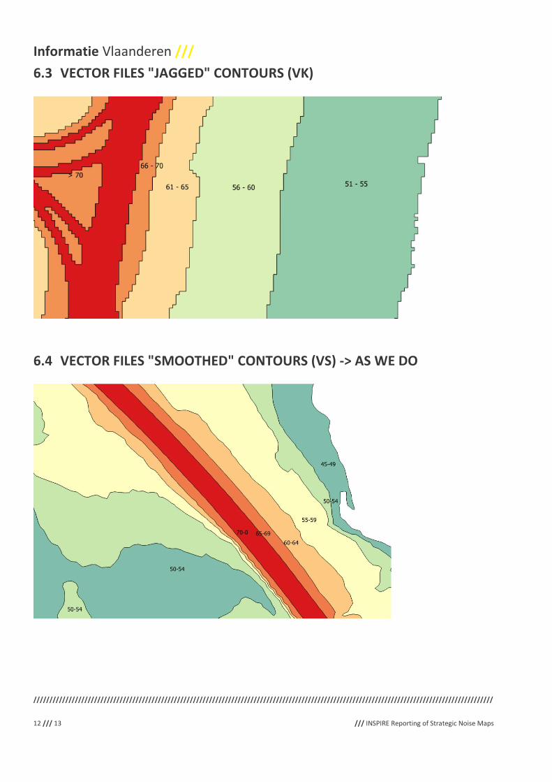
are four types of maps that are being used interchangeably and / or published by the different member states (see
Annex 1) :
• Raster Images with continuous values (Rc): this corresponds to the crude output of the acoustic model.
• Raster Images discrete classes (Rd)
• Vector Files "jagged" contours (Vk)
• Vector Files "smoothed" contours (Vs) -> as we do
The "Data Specifications" from the "Human Health & Safety" do indeed mention noise, and even Directive 2002/49.
But the specifications are not written to describe this kind of modeled and full coverage maps.
This issue was already raised, but it barely elicited any responses on both the Thematic Cluster pages 23 and on the
INSPIRE Data Specifications Special Interest Group forum4. We believe that the inclusion of these datasets on the
priority lists makes a revival of this discussion appropriate.
We hereby invite other MS to join these online conversations.
2.3 INPUT DATA
The input data used for the production of the Environmental Noise Maps also needs to be published and reported
under the INSPIRE directive.
As listed in the Irish Guidance Note for Strategic Noise Mapping5 the noise mapping process requires a wide range of
input datasets, many of which need to be spatially referenced. An overview of the type of datasets required in order
to carry out the noise level calculations is shown below:
• 3D Model Environment:
o DTM – 3D surface model;
o DEM – 3D building heights;
o Break lines;
1 http://www.geopunt.be/catalogus/search?facet=catalog&q=geluid
2 https://themes.jrc.ec.europa.eu/discussion/view/53288/environmental-noise-directive
3 https://themes.jrc.ec.europa.eu/discussion/view/5333/human-health-and-safety-implementation-examples
4 https://inspire-forum.jrc.ec.europa.eu/mod/groups/topicposts.php?topic=2034&group_guid=1747
5 P28 of Guidance Note for Strategic Noise MApping version 2 (august 2011) – EPA Ireland -
https://www.epa.ie/pubs/advice/noisemapping/EPA%20Guidance%20Note%20for%20Strategic%20Noise%20Mapping%20(version%202).pdf

Informatie Vlaanderen ///
////////////////////////////////////////////////////////////////////////////////////////////////////////////////////////////////////////////////
8 /// 13 /// INSPIRE Reporting of Strategic Noise Maps
o Embankments & Cuttings;
o Topography;
o Bridges / Underpasses; and
o Barriers.
• Road source:
o Carriageway centreline;
o Traffic flow;
o Traffic speed;
o %HGVs;
o Road surface type; and
o Road texture depth.
• Rail source:
o Rail centreline;
o Traffic flow;
o Train speed;
o Train type; and
o Railhead roughness.
• Industry source:
o Location;
o Process type; and
o Noise emission level.
• Aircraft Source:
o Flight track;
o Aircraft type; and
o Power level along flight track.
The analysis environment will typically require a number of datasets, including several not required for the noise
calculation process:
• Information on residential population numbers;
• Population distribution information;
• Identification of buildings as dwellings or other noise sensitive premises, such as schools and hospitals; and
• Location of premises with special noise insulation measures.
The gathering and reporting of some of these datasets has already happened (under Annex I &II), but for other data
this seems more challenging. Especially for the case of radar tracks from airports which are potentially subject to
copyrights.
Questions arise as to the feasibility, (restricted) public access (for data that may not be published) and maintenance.
At this point in time it seems appropriate to inquire about the plans of the other MS.
/// Informatie Vlaanderen
////////////////////////////////////////////////////////////////////////////////////////////////////////////////////////////////////////////////
INSPIRE Reporting of Strategic Noise Maps /// 9 /// 13
3 TENTATIVE SOLUTIONS
This is not meant to be a comprehensive overview of solutions. It only highlights efforts that have come to our
attention. MS are invited to add or highlight their experiences and tentative solutions.
3.1 FLANDERS
Due to the state of the current requirements the Flemish approach boils down to converting the Shapefiles to GML
and subsequently reprojecting from the local CRS to ETRS89.
An additional problem of the current ambiguity is that there are difficulties to accurately define what a contractor
needs to deliver when subscribing to public procurements. The easy way out is saying that all data has to be INSPIRE
compliant. But how can one expect contractors to comply to requirements one has not yet fully understood.
3.2 FRANCE – COVADIS
At this point it is useful to mention the work of the French COVADIS6 workgroup on the strategic noise maps. A detailed
data standard7 was developed and published in November 2015. Especially interesting in this context are Chapters B
and C where a full proposal is worked out for a conceptual data model and physical data structure.
But it also highlights the problems we encounter in that local or national initiatives can be initiated, but they are not
imbedded in existing (INSPIRE) data specifications. In this light the work realized by COVADIS could be extended to all
Member States.
As far as we are aware this document from COVADIS is not binding, because there are no binding specifications for
strategic noise maps within Directive 2002/49. As such the application of the COVADIS data model does not guarantee
its compliance with a yet to be developed uniform data model for all MS. And thus the explicit risk exists that the data
harmonization effort would have to be started all over again.
4 DATA HARMONISATION
We would like to re iterate our position on the harmonization of the Environmental Noise Maps reported under the
requirements of Directive 2002/49/EC.
The data will be harmonized only if, and when the reporting requirements of both directives have been officially
aligned. The data that is currently provided in accordance to the directive 2002/49/EC cannot be provided under the
current INSPIRE specifications as this would require a duplication of work and represents an unfair burden on the
already resource stretched administration. It is also our firm belief that the duplication of what is essentially one
dataset is not conform with the underlying philosophy of the ongoing REFIT exercise at the Commission level.
This being said we are aware that our current approach does not answer the INSPIRE harmonization requirements.
External experts (SADL) were asked to verify our current (meta-) data for compliance with the INSPIRE Directive. The
conclusion has been that under the current circumstances where the data cannot be mapped to the requirements the
data might be exempt from the harmonization requirement. We are interested in the opinion of the other MS and of
the Commission.
6Commission de validation des données pour l'information spatialisée -
7 http://www.territoires-ville.cerema.fr/IMG/pdf/COVADIS_standard_BruitEnvironnement-CartographieBruit_v1-0_cle522f8b.pdf

Informatie Vlaanderen ///
////////////////////////////////////////////////////////////////////////////////////////////////////////////////////////////////////////////////
10 /// 13 /// INSPIRE Reporting of Strategic Noise Maps
5 CONCLUSION
As pointed out in this document there are several barriers to the reporting of the Environmental Noise Maps
produced under the requirements of Directive 2002/49/EC.
In order to overcome these barriers we would like to hear in depth reactions from the other MS (outlining their
approach and problems if possible) and of the Commission.
We specifically appreciate the detailed work by COVADIS, but it is as yet no guarantee to reach INSPIRE conformity in
the future. For our purposes it remains to this day an excellent, but not standard initiative to solve the problem of
lacking guidelines.
As it seems most appropriate to start this discussion at the MIG-T level this document will be submitted as starting
point for a MIG-T issue.

/// Informatie Vlaanderen
////////////////////////////////////////////////////////////////////////////////////////////////////////////////////////////////////////////////
INSPIRE Reporting of Strategic Noise Maps /// 11 /// 13
6 ANNEX 1: EXAMPLE ENVIRONMENTAL NOISE MAPS
6.1 RASTER IMAGES WITH CONTINUOUS VALUES (RC): THIS CORRESPONDS
TO THE CRUDE OUTPUT OF THE ACOUSTIC MODEL.
6.2 RASTER IMAGES DISCRETE CLASSES (RD)
Informatie Vlaanderen ///
////////////////////////////////////////////////////////////////////////////////////////////////////////////////////////////////////////////////
12 /// 13 /// INSPIRE Reporting of Strategic Noise Maps
6.3 VECTOR FILES "JAGGED" CONTOURS (VK)
6.4 VECTOR FILES "SMOOTHED" CONTOURS (VS) -> AS WE DO

/// Informatie Vlaanderen
////////////////////////////////////////////////////////////////////////////////////////////////////////////////////////////////////////////////
INSPIRE Reporting of Strategic Noise Maps /// 13 /// 13
7 ANNEX 2 : CONTACT DETAILS
More information can be gathered from the authors by contacting them at the following addresses
Mr. Tom Akkermans - Beleidsmedewerker geluidshinder
DEPARTEMENT LEEFMILIEU, NATUUR & ENERGIE
Afdeling Lucht, Hinder, Risicobeheer, Milieu & Gezondheid
� +32 (0)2 553 62 55
Koning Albert II-laan 20 bus 8, 1000 Brussel
www.lne.be
Mr. Ouns Kissiyar - INSPIRE NCP
INFORMATIE VLAANDEREN
� +32 (0)9 276 14 80