
Initial Findings and Response Actions - State · Initial Findings and Response Actions Karen...
39
Akhaldaba Landslide (Photo courtesy of GeoGraphics GIS and Remote Sensing Consulting Center) Initial Findings and Response Actions Karen Bennett – Team Leader -USFS Geoscientist, Watershed Specialist Jolene Gosselin-Campbell – USFS Civil Engineer Liz Schnackenberg – USFS Hydrologist, Fluvial Geomorphologist 1
Transcript of Initial Findings and Response Actions - State · Initial Findings and Response Actions Karen...
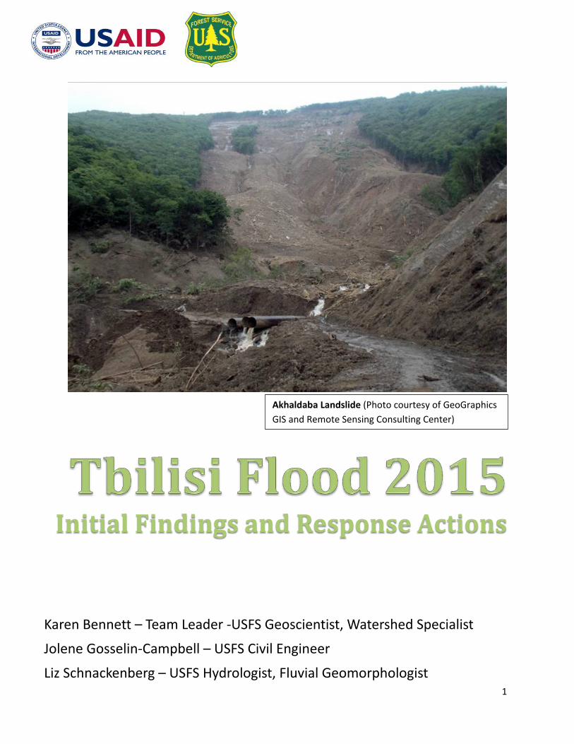
Akhaldaba Landslide (Photo courtesy of GeoGraphics GIS and Remote Sensing Consulting Center)
Initial Findings and Response Actions
Karen Bennett – Team Leader -USFS Geoscientist, Watershed Specialist
Jolene Gosselin-Campbell – USFS Civil Engineer
Liz Schnackenberg – USFS Hydrologist, Fluvial Geomorphologist
1

Table of Contents
Executive Summary………………………………………………………………………………………………………………..3 I. Background…………………………………………………………………………………………………………………………….5
II. Project Goals…………………………………………………………………………………………………………………………..5 III. Site Assessment……………………………………………………………………………….……………………………………. 5 IV. Storm Impact Assessment……………………………………………………………………………………………..…..…13 V. Value Analysis…………………………………………………………………………………………………………………….. 17
VI. Risk Assessment……………………………………………………………………………………………………………………18 VII. Response Actions………………………………………………………………………………………………………………….19
VIII. Conclusions…………………………………………………………………………………………………………………………..38 IX. References………………………………………………………………………………………………………………………..….39
Acknowledgements:
The USFS team wishes to thanks the entire community of people with whom we worked for their incredible hospitality and accommodating nature in the face of the disaster they had just been through. We are especially grateful to USAID (Carol Wilson and Veronica Lee) for all their logistical support and guidance and to the Ministry of Environment for Natural Resource Protection and City Hall for sharing their knowledgeable staff with us which helped us rapidly understand the situation. We wish to specifically thank Giorgi Gaprindashvili and Omari Abutidze from the Department of Geology for spending several days in the field with us, Sgt. Jason Stender of the Marine Corp who accepted every data gathering challenge we put before him and Cpt. Jarret Redman, US Army Civil Affairs, for having documents translated and sharing his knowledge of the incident. We also thank Dimitri Tatinashvili from City Hall for the tour and insights into flood damages within the City limits and to Irakli from the Department of Hydrology and Meteorology for sharing stream flow and climate data. A special thanks goes to Levan Lominadze of USAID who walked the streams of Georgia for the first time in his life and whose humor kept us going “just one more bend” and to Mariam Tevzadeze USFS in-country staff who has everyone who’s anyone on speed dial and worked diligently to gather all the many bits of information we asked for.
2
Tbilisi Flood 2015 Initial Findings and Response Actions
Executive Summary
The Flood of June 13, 2015 took 19 lives, destroyed housing and highway infrastructure and flooded the zoo, killing many of the animals. This was a multi-hazard event with intense rainfall. According to the National Environmental Agency (NEA) and Caucasus Environmental NGOs Network report, approximately 100 mm of rain fell in 3-4 hours on already saturated soil conditions. Hundreds of landslides ensued, bringing trees, rocks and soil down from the hillsides and merged with the floodwaters of the Vere River. Upon reaching the City of Tbilisi, the tunnel system constricted the flow, backing up the river until sufficient pressures drove the material through the tunnels in a manner known as dam breach hydrology. The first tunnel within the city limits is 72m2, each of the following seven tunnels through town are 18m2 smaller than the first tunnel. When the flood flows exited the culverts, which were undersized to handle the sediment and debris laden flow, the force of the sediment bulked water eroded stream banks, the Chabua Amirejibi highway, and anything in its path. Upon reaching the final tunnel which goes underground for 1100m from an area upstream of the zoo to the outlet of the Mtkvari River, the floodwaters were backed up and the stream occupied its historic floodplain in the area of Mziuri Park and the Tbilisi Zoo where large quantities of sediment and debris were deposited. In order to understand why the debris laden flood occurred, what the impacts were on the city, and which response actions should be taken, it is important to understand the natural processes that drive stream system dynamics in the Vere River watershed. The area is geologically young and highly erodible due to the weak sedimentary rocks. On the south side of the watershed, the bedding plain of the rocks parallels the slope like a tilted deck of cards poised to slip past one another. This portion of the watershed poses the highest slope stability hazard and is where the largest landslide, by the village of Akhaldaba, occurred. Additional high slope stability hazards were mapped by this team with the help of staff from the National Environmental Agency (NEA). The Vere River meanders dramatically back and forth eroding the outer bank of almost every bend as it winds its way down stream. The river carries so much sediment naturally that it is a multi-strand braided system that occupies almost the entire canyon floor. River terraces develop on the inner bends of the river where native cottonwood trees and various shrubs colonize the site. These trees are natural trash racks, storing tons of sediment and debris during flood events. Human impacts in the watershed have altered the natural forest cover, reduced forest recovery with free range grazing pressures, and constructed many roads and several villages. These land uses have accelerated the timing of flow to the river system and increased peak flood events over time.
3
The team developed a series of immediate, mid-term, and long-term response actions that are targeted toward improving the resilience of the upper watershed and the smaller Ukhankhevi sub-watershed, and restoring natural stream functions through the City of Tbilisi. Although the City and local communities have done a fantastic job of cleaning up from the flood and initiating rebuilding efforts, the key messages to prepare for the future are:
• Take time to fit the restoration efforts into a holistic strategy for managing the river system. With climate change models predicting more storms of greater intensity during the spring, like the one just experienced, the need to develop a stream system that accepts these storm events without disastrous results is imperative.
• Reduce the level of peak floods by regulating roads, improving road construction techniques,
restoring riparian and upland forests, and restricting development and road construction in areas where they will accelerate the rate of landslide activity.
• Decrease the risk to life, property, infrastructure, and cultural resources by allowing the stream
to function naturally. This requires designating stream management zones, removing infrastructure, regulating development within the stream management zones, and engaging in comprehensive land use planning. It also requires understanding the probable maximum flood flow through the City of Tbilisi, reducing constrictions imposed by the tunnel system, and allowing the stream to occupy its floodplain in an urban green corridor that both protects the city and increases the quality of life of the community.
4
I. Background Information
The Vere River watershed flows east into the Capitol City of Tbilisi. On the night of June 13, 2015, starting about 11PM, flood flows started to be seen within the Vere River Gorge within the Tbilisi City limits. For the next several hours, the flooding greatly increased causing both inundation of some areas and scouring and deposition of debris in other areas. The Chabua Amierjibil Highway, constructed in 2008-9, was washed out in several places, houses, businesses, and schools were inundated and the zoo was flooded. 19 people lost their lives with 3 people missing, 40 homes were destroyed with others damaged and many endangered animals housed at the zoo were drowned by the flood or buried with debris. Many reports are available (NEA 2015, CENN 2015) which describe the impact zones, so they will not be repeated here. The exact amount and timing of rain that began in the upper watershed is not known due to a lack of a rain gauge data collection system. However, estimates from the Ministry of Environment, Department of Hydrology and Meteorology state that the watershed received about 100mm of rain in 3-3.5 hours (CENN,2015). Hundreds of landslides occurred as a result of the antecedent moisture conditions. Meteorological records from the Tbilisi rain gauge indicate that 60% of the average annual rainfall occurred in the 75 days preceding this event (NEA 2015). As a result, the ground was already saturated when the storm occurred. The resulting landslides and stream flows did considerable damage to life and property both in the upper watershed and within the Vere River corridor through the City of Tbilisi.
II. Project Goals: In response to the Tbilisi flood damage of June 13-14, 2015, USAID requested assistance from the USDA Forest Service for a rapid one week assessment to: • Perform a site assessment including a field review of the Vere River watershed • Assess Storm Impacts in various portions of the watershed • Understand the values important to the City of Tbilisi and the Ministry of the Environment • Assess future threats • Provide recommendations for Response Actions that might be implemented in the immediate,
mid, and long-term to mitigate imminent threats to values identified above which create resilience in the watershed to be able to withstand similar events in the future
This is not an assessment of highway or infrastructure damages or safety
III. Site Assessment - Understanding the Vere River Watershed
Understanding the inherent geo-ecology of the watershed is the first step to understanding why this event occurred, the potential for an event of this type to occur again, and recommendations for appropriate mitigation or response actions. This phase includes understanding the inherent factors such as climate, geology, geomorphology (landforms) and soils, as well as stream channel characteristics and natural vegetation patterns.
5

Precipitation: The Vere River Watershed is oriented in an east to west direction flowing in to the Mtkvari River at the Capital City of Tbilisi. The watershed is 156 km2 in size. Storms tend to come in from the south hitting the most unstable portion of the watershed first.
The monthly average precipitation from the Tbilisi weather station (Figure 1) shows that the highest monthly rainfall occurs in April, May, and June with 60, 82 and 78 mm respectively. Annually an average of 507 mm of rain is received in Tbilisi. Slightly higher precipitation rates are expected to occur with increased elevation toward the upper parts of the Vere watershed. The spring of 2015 was particularly wet with about 300mm of rain falling in the 75 days prior to the June 13th event (source
MENRP). That is about 60% of the annual rainfall occurring in a 2.5 month period. Normally only 43% of the rain occurs during that period. As a result, antecedent soil moistures were already elevated when the high intensity short duration storm hit the watershed on the night of June 13, 2015. Annual rainfall has increased by 6% over the last half century. Anticipated changes in precipitation with climate change are that annual precipitation will not change but there will be an increase in monthly precipitation during the spring and a maximum decrease in the summer months. So potentially the type of storm that occurred in June 2015 will not be a rare event in the future. Geology/Geomorphology/Soils The watershed is part of the lesser Caucus Mountains which are geologically a young mountain range that is still actively uplifting and eroding. The bedrock consists of interbedded layers of sandstone, siltstone, and clay or mudstone arranged in various combinations. The young, weakly cemented layers are very incompetent (crumble easily) and are therefore highly erodible. Depending on the type and quantity of the various sedimentary rock units (Figure 2), certain areas of the watershed are more or less prone to landslide, earth flow or rockfall events. In addition, uplift of these layers, along fault zones during the mountain building events, has resulted in rock layers in the Vere watershed that are tilted toward the
Figure 2: Interbedded layers of sandstone, siltstone and claystone are weak, easily decomposed and eroded.
Figure 1: Mean monthly precipitation from the Tblisi rain gauge. Source: MERNP Dept of Hydrology and Meteorology
6

north (Figure 3). Therefore, along the south side of the Vere watershed, the slope of the land is directly parallel to the layers of the bedrock. Like a tilted stack of cards that can easily slip past one another.
Natural decomposition of the surface material results in weathering of the rock to soil. As weathering proceeds, a weak rock layer (usually with a high clay composition) is eventually encountered. When conditions are right, i.e. sufficient weight of the overburden rock and soil and high moisture content, landslides result.
The soils in the project area range from shallow, loamy, very gravelly, highly calcareous material to very deep, clay-rich, soils that result from ancient earthflow activity to deep sand accumulations on stream terraces. The variation in soil affects the water holding capacity and the timing of saturation in various areas and the types of vegetation it will support. Slope Stability: During the night of June 13, 2015, significant landslide activity occurred within the Vere watershed. The Ministry of Environment and Natural Resources Protection (MENRP) Department of Geology mapped 75 landslides within the vicinity of the community of Akhaldaba and the large landslide which occurred there. The landslide delineation totaled 13.3 sq km of area—almost all at or downstream of large landslide (none upstream of the large landslide). The mapping also identified an additional 28 points of landslide occurrence (includes 1 rockfall), which were not delineated as polygons. This means that 7% of the lower watershed (from the site of the Akhaldaba landslide downstream to Tbilisi) was affected by landslides from this storm. Landslides and earthflows, numbering in the 100s, occurred both upstream and downstream of this area predominately on the south side of the Vere River but also on the north side to a more limited degree. The largest landslide, near the town of Akhaldaba, was approximately 32 hectares in size, traveled 1.3 km to the junction with the mainstem of the Vere River, and produced approximately 1 million cubic meters of sediment according to MENRP (NEA 2015). A preliminary Slope Stability Hazard Map, which includes areas of potential rockfall, earthflow and landslides (Figure 4), was created by this team, in conjunction with the geology staff of the MENRP, as a way to display the potential for the unstable lands
Figure 3: Bedrock layer dipping toward the north parallel to slope is prone to landslides.
7

in various portions of the Vere River Watershed. The results from this mapping effort indicate that 8% and 11 % of the entire watershed is potentially high and moderate slope stability hazard respectively.
Using the LiDar (Light detection and radar) image previously acquired by the City of Tbilisi is a much better tool for initial modelling of potentially unstable lands. The MENRP is scheduled to receive full LiDar coverage of the watershed by the end of July 2015 which can be used for more detailed slope stability hazard mapping within the watershed. Using the information available of just a portion of the southern section of the Vere River watershed shows the slope stability hazard increases to 12% high and 21% moderate potential indicating the higher density and spatial coverage of potential geo-hazards in the southern portion of the watershed (Figure 5). These preliminary maps are best used to help strategically locate field sampling of geo-hazards and not as a definitive indication of slope instability. A field-based mapping of geo-hazards is recommended. Geo-hazard information is a critical base layer for any development that may occur in the watershed, especially in regard to siting roads and community development. Understanding the inherent landslide risk of an area helps to minimize potential losses to life and property. It is important to understand that the Vere River watershed, especially the southern portion, is a very actively eroding landscape. Even prior to the flood event many chronic landslides are apparent. During the June 13 storm event, a large landslide initiated in the drainage just southeast of the village of Akhaldaba. Although difficult to re-create the exact sequence of events, given the remaining blocks of rafted trees above the Tsknetki Hwy., we suggest that the landslide started as a result of a deep layer of saturated soil that liquefied at the convergence of multiple headwall systems below the highway. The positive pore pressure started the soil flowing, it accumulated so much material that it resulted in a
Figure 4: Preliminary Slope Stability Hazard Map of the Vere River Watershed. The southern portion of the watershed has the highest potential landslide hazard and was the major source of sediment and debris during the flood of June 13, 2015
Tbilisi
Akhaldaba
Tsneketi
44%
36%
11%
8%
N
8

debris flow which carried rock, soil, and trees all the way into Tbilisi. The evacuation of soil from the headwall resulted not only in a debris flow downstream but also progressed headward undercutting the landscape above eventually undercutting the weathered rock mantel under and through the road. The headcutting above the road resulted in blocks of rock, soil, and trees being rafted down slope in a series of progressive arcs, each one destabilizing the integrity of the slope above it. If the slide had started at the top of the ridge, as is assumed by some, it seems that these blocks would have continued downslope with all the other material. The upper area, according to MENRP geologists consulting with us in the field, is at the junction of several faults. As a result the fracture pattern in the rock allowed water from the storm to penetrate deeply into the bedrock lubricating it and allowing it to fail along the clay layers. Scarps and cracks can be seen in the forest above and to each side of the main slide area. There is still a significant amount of unstable debris remaining in this slide area. Stream System Dynamics: Flood flow routing and timing in natural stream systems is governed by multiple factors including:
1) valley form, 2) sinuosity and stream gradient, 3) water, sediment and other debris products (e.g. wood) supplied by the watershed, 4) floodplain availability, and 5) the condition of the adjacent riparian area
N
Tbilisi
3%
64%
21%
12%
AkhaldabaTskneti
Figure 5: Same Preliminary Landslide map as in Figure 4 above, however this one uses LiDar imagery which provides significantly more detail and improves the quality and specificity of the areas with potential slope stability hazards
9
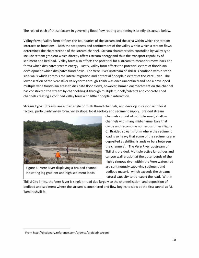
The role of each of these factors in governing flood flow routing and timing is briefly discussed below. Valley form: Valley form defines the boundaries of the stream and the area within which the stream interacts or functions. Both the steepness and confinement of the valley within which a stream flows determines the characteristic of the stream channel. Stream characteristics controlled by valley type include stream gradient which directly affects stream energy and thus the transport capability of sediment and bedload. Valley form also affects the potential for a stream to meander (move back and forth) which dissipates stream energy. Lastly, valley form affects the potential extent of floodplain development which dissipates flood flows. The Vere River upstream of Tbilisi is confined within steep side-walls which controls the lateral migration and potential floodplain extent of the Vere River. The lower section of the Vere River valley form through Tbilisi was once unconfined and had a developed multiple wide floodplain areas to dissipate flood flows, however, human encroachment on the channel has constricted the stream by channelizing it through multiple tunnels/culverts and concrete lined channels creating a confined valley form with little floodplain interaction. Stream Type: Streams are either single or multi thread channels, and develop in response to local factors, particularly valley form, valley slope, local geology and sediment supply. Braided stream
channels consist of multiple small, shallow channels with many mid-channel bars that divide and recombine numerous times (Figure 6). Braided streams form where the sediment load is so heavy that some of the sediments are deposited as shifting islands or bars between the channels1. The Vere River upstream of Tbilisi is braided. Multiple active landslides and canyon wall erosion at the outer bends of the highly sinuous river within the Vere watershed are continuously supplying sediment and bedload material which exceeds the streams natural capacity to transport the load. Within
Tbilisi City limits, the Vere River is single thread due largely to the channelization, and deposition of bedload and sediment where the stream is constricted and flow begins to slow at the first tunnel at M. Tamarashvili St.
1 From http://dictionary.reference.com/browse/braided+stream
Figure 6: Vere River displaying a braided channel indicating log gradient and high sediment loads
10
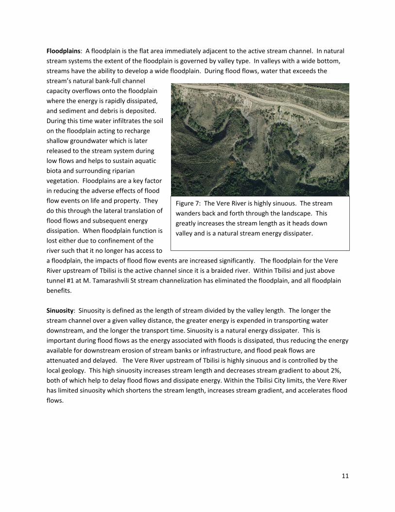
Floodplains: A floodplain is the flat area immediately adjacent to the active stream channel. In natural stream systems the extent of the floodplain is governed by valley type. In valleys with a wide bottom, streams have the ability to develop a wide floodplain. During flood flows, water that exceeds the stream’s natural bank-full channel capacity overflows onto the floodplain where the energy is rapidly dissipated, and sediment and debris is deposited. During this time water infiltrates the soil on the floodplain acting to recharge shallow groundwater which is later released to the stream system during low flows and helps to sustain aquatic biota and surrounding riparian vegetation. Floodplains are a key factor in reducing the adverse effects of flood flow events on life and property. They do this through the lateral translation of flood flows and subsequent energy dissipation. When floodplain function is lost either due to confinement of the river such that it no longer has access to a floodplain, the impacts of flood flow events are increased significantly. The floodplain for the Vere River upstream of Tbilisi is the active channel since it is a braided river. Within Tbilisi and just above tunnel #1 at M. Tamarashvili St stream channelization has eliminated the floodplain, and all floodplain benefits. Sinuosity: Sinuosity is defined as the length of stream divided by the valley length. The longer the stream channel over a given valley distance, the greater energy is expended in transporting water downstream, and the longer the transport time. Sinuosity is a natural energy dissipater. This is important during flood flows as the energy associated with floods is dissipated, thus reducing the energy available for downstream erosion of stream banks or infrastructure, and flood peak flows are attenuated and delayed. The Vere River upstream of Tbilisi is highly sinuous and is controlled by the local geology. This high sinuosity increases stream length and decreases stream gradient to about 2%, both of which help to delay flood flows and dissipate energy. Within the Tbilisi City limits, the Vere River has limited sinuosity which shortens the stream length, increases stream gradient, and accelerates flood flows.
Figure 7: The Vere River is highly sinuous. The stream wanders back and forth through the landscape. This greatly increases the stream length as it heads down valley and is a natural stream energy dissipater.
11

Riparian areas/vegetation: Riparian vegetation plays a multi-faceted role during flood flows. The extensive root system of riparian vegetation stabilizes streambanks and protects them from erosion. Streambank erosion can contribute additional sediment during flood flows, thus increasing both sediment bulking and peak flows. Riparian vegetation can also act to trap sediment and bedload and act as a natural debris ‘trash’ rack or debris filter (Figure 8). Riparian areas upstream of Tbilisi are limited to terraces adjacent to the active channel within the confined valley. Vegetation is comprised of deciduous species such as cottonwood trees with understory shrubs. Several examples were observed where large cottonwood trees acted to capture and prevent natural debris from moving downstream. Grazing within the Vere River system has limited cottonwood regeneration and only old, established trees were seen. Culverts and stream dynamics: Culverts alter stream dynamics by eliminating floodplain connection potential and by accelerating flow. Stream flow velocities are reduced within culverts as a result of a reduction in width. Stream velocities entering a culvert are generally lower than stream velocities exiting the culvert. As a result, the energy available for stream bank erosion and channel scour downstream of the culvert is increased thus increasing sediment and bedload transport. Within Tbilisi, approximately 50% of the Vere River is in a tunnel or culvert, and there are a total of eight tunnels/culverts. Constriction of such a high percent of the stream accelerates flood flows and increases erosive energy. The capacity of the culvert/tunnel system, and anticipated maximum flood flows, was not evaluated in this assessment, but regardless of culvert capacity, the culvert/tunnel system acts to increase velocity relative to a meandering stream channel with access to a floodplain. It was noted that the culvert dimensions decrease below the first tunnel with the first tunnel having dimensions of 9 meters in width and 8 meters in height and all lower culverts having dimension of 9 meters in width but only 6 meters in height, resulting in a cross sectional capacity loss of 18 m2 If you multiply this times the total length of the culvert system, there would be a significant loss in volume which further exacerbates the acceleration of flow.
Figure 8: Riparian vegetation maintains stream bank stability and serves as a natural trash rack storing and slowly routing debris through the stream
12
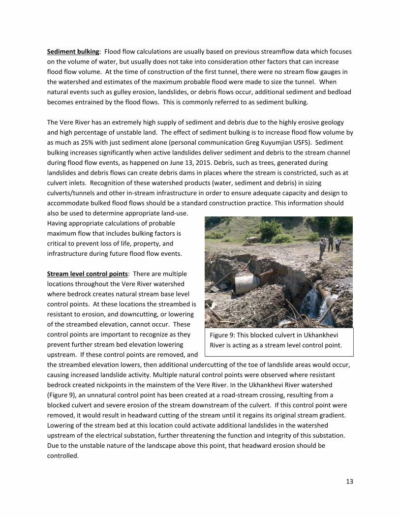
Sediment bulking: Flood flow calculations are usually based on previous streamflow data which focuses on the volume of water, but usually does not take into consideration other factors that can increase flood flow volume. At the time of construction of the first tunnel, there were no stream flow gauges in the watershed and estimates of the maximum probable flood were made to size the tunnel. When natural events such as gulley erosion, landslides, or debris flows occur, additional sediment and bedload becomes entrained by the flood flows. This is commonly referred to as sediment bulking. The Vere River has an extremely high supply of sediment and debris due to the highly erosive geology and high percentage of unstable land. The effect of sediment bulking is to increase flood flow volume by as much as 25% with just sediment alone (personal communication Greg Kuyumjian USFS). Sediment bulking increases significantly when active landslides deliver sediment and debris to the stream channel during flood flow events, as happened on June 13, 2015. Debris, such as trees, generated during landslides and debris flows can create debris dams in places where the stream is constricted, such as at culvert inlets. Recognition of these watershed products (water, sediment and debris) in sizing culverts/tunnels and other in-stream infrastructure in order to ensure adequate capacity and design to accommodate bulked flood flows should be a standard construction practice. This information should also be used to determine appropriate land-use. Having appropriate calculations of probable maximum flow that includes bulking factors is critical to prevent loss of life, property, and infrastructure during future flood flow events. Stream level control points: There are multiple locations throughout the Vere River watershed where bedrock creates natural stream base level control points. At these locations the streambed is resistant to erosion, and downcutting, or lowering of the streambed elevation, cannot occur. These control points are important to recognize as they prevent further stream bed elevation lowering upstream. If these control points are removed, and the streambed elevation lowers, then additional undercutting of the toe of landslide areas would occur, causing increased landslide activity. Multiple natural control points were observed where resistant bedrock created nickpoints in the mainstem of the Vere River. In the Ukhankhevi River watershed (Figure 9), an unnatural control point has been created at a road-stream crossing, resulting from a blocked culvert and severe erosion of the stream downstream of the culvert. If this control point were removed, it would result in headward cutting of the stream until it regains its original stream gradient. Lowering of the stream bed at this location could activate additional landslides in the watershed upstream of the electrical substation, further threatening the function and integrity of this substation. Due to the unstable nature of the landscape above this point, that headward erosion should be controlled.
Figure 9: This blocked culvert in Ukhankhevi River is acting as a stream level control point.
13
Vegetation Patterns: The Vere River watershed was once dominated by forests. In this analysis, we have not determined percentages of existing vegetation and developed areas but in general, the watershed has a mix of forests, grasslands, developments, and eroded landscapes. Around the Akhaldaba landslide area, we found that the forests are all second growth, with a high density of young (~50 year old) trees. Helicopter reconnaissance revealed that the Northwest corner of the watershed is highly forested with what appear to be much older forests. Forested landscapes have a huge role in reducing streamflow and stabilizing hillslopes. Tree roots provide stability to soils by establishing anchor roots which, depending on species, penetrate 3-7 feet into the soil surface (source University of Chicago) thereby reducing slope stability hazards. This is especially true in areas where the roots can penetrate into the bedrock which is the case in these weakly cemented sedimentary rocks of the Vere River watershed. Forest canopies intercept precipitation and store water in the canopy itself. This water later evaporates back into the atmosphere. Trees also utilize water through respiration. The forest soils have a good litter layer, low soil densities and high infiltration rates. Water that passes through the canopies infiltrates quickly avoiding runoff to streams and enhancing the storage and slow release of precipitation to the stream system over time. The combination of anchoring, interception, evaporation, infiltration, storage and slow release, all work together in a healthy forest ecosystem to reduce the water available to contribute to flood flows and thus provide ecosystem services to communities looking for flood protection downstream.
Current and historic human use of the watershed has altered much of the lands ability to function as described above, forests have been harvested, and the land has been converted to villages and cities with a network of roads which quickly shed water. We did not see any drainage structures on the road system. A road drainage system allows water that is intercepted either in roadside ditches or on the road surface during storm events to be quickly returned at regular intervals and at rates which can be easily infiltrated on the slopes below where it can once again become part of the soil storage or groundwater system. Instead we saw that the storm had resulted in much damage to the road system, either by taking the whole road out in landslide events, blowing out undersized and poorly constructed culverts at stream crossings, or eroding in the ditchlines which were overwhelmed by the quantity of water with no cross drainage in place to relieve the size of the flow. We saw many rural roads that run directly perpendicular to the contour of the ridges or directly up the gut of the stream channel which eroded into deep gullies during the storm. That runoff eventually ran directly into the stream system serving in fact to extend the stream system and increasing the size of the peak flood event. Compacted grasslands that result from heavy grazing pressures also shed water more rapidly than native forest systems and add to the peak flood events.
IV. Storm Impact Assessment Storm Conditions and Flood Flows We were told, based on interviews that the precipitation in the headwaters began at about 10:30pm on the night of June 13th,2015, the flooding in the City began about 1pm. Our rough calculations estimated a time of concentration of about 110 minutes which roughly coincides with the timing of events related
14

to this team. Time of concentration is defined as a measure of the response of a watershed to a rain event; the time needed for the water to flow from the most remote point to the watershed outlet. It is a function of the topography, geology and land use within the watershed. The MERNP Department of Hydrology and Meteorology estimates that the flood was flowing at 438m3/second when it arrived at the first culvert in Tbilisi and that based on hydrologic records, that equates to a 300 year return period storm (NEA 2015). Our understanding of the sequence of events is as follows, however, to understand it fully and to be able to use that information in any redesign of the Tbilisi Vere River stream and tunnel/culvert system, we encourage that a model of the storm and flow events be recreated. Hundreds of landslides and undercutting of steep stream-adjacent slopes occurred in the upper watershed with the largest landslide occurring in the headwaters of the stream just east of the Akhaldaba community. Our aerial reconnaissance by helicopter revealed that the storm impacted the entire length of the watershed with trees laid over and both scouring and deposition apparent from the upper southwest tributary through Tbilisi. The tributaries coming in to the Vere River from the north had less visible impact in the upper watershed than from some of those toward the lower or more easterly portion of the watershed. There is much conjecture as to whether a dam was created by landslides in the upper watershed that broke and caused all the damage. Our reconnaissance of the Akhaldaba landslide revealed that as the debris torrent hit the mainstem of the Vere River, the viscosity of the water and debris from the tributary stream was enough to backwater the mainstem River. As the flood flows from the mainstem
backed up and increased in elevation, they eventually broke through the debris slide and carried much
Figure 10: Earthflow (A) and rockfall (B) areas are active in the lower Ukankhevi River that meets the Vere River just above Tbilisi. These geo-hazards are perched just upstream of the electricity sub-station and water supply systems that serve the city of Tbilisi. Those utilities are built over the stream channel at a point where three streams come together and are threatened by these hazards.
A B
15
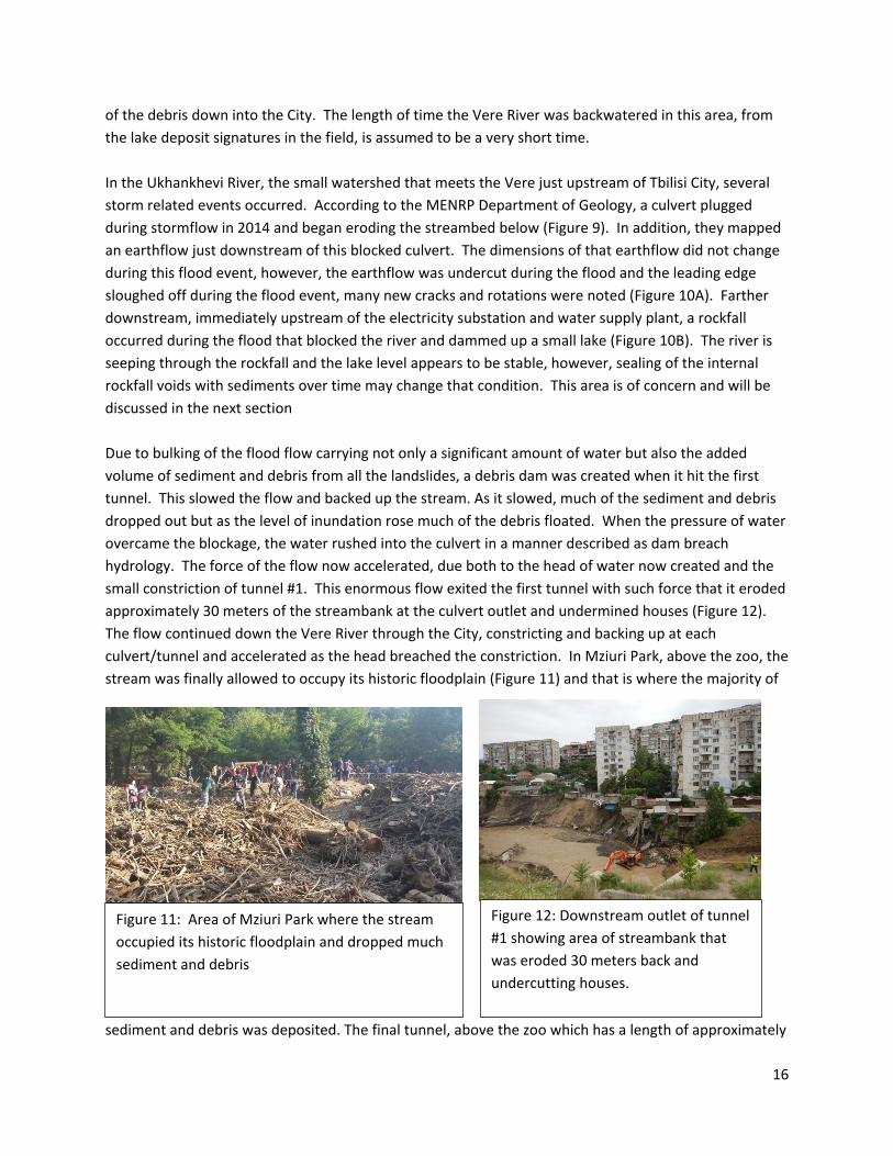
of the debris down into the City. The length of time the Vere River was backwatered in this area, from the lake deposit signatures in the field, is assumed to be a very short time. In the Ukhankhevi River, the small watershed that meets the Vere just upstream of Tbilisi City, several storm related events occurred. According to the MENRP Department of Geology, a culvert plugged during stormflow in 2014 and began eroding the streambed below (Figure 9). In addition, they mapped an earthflow just downstream of this blocked culvert. The dimensions of that earthflow did not change during this flood event, however, the earthflow was undercut during the flood and the leading edge sloughed off during the flood event, many new cracks and rotations were noted (Figure 10A). Farther downstream, immediately upstream of the electricity substation and water supply plant, a rockfall occurred during the flood that blocked the river and dammed up a small lake (Figure 10B). The river is seeping through the rockfall and the lake level appears to be stable, however, sealing of the internal rockfall voids with sediments over time may change that condition. This area is of concern and will be discussed in the next section Due to bulking of the flood flow carrying not only a significant amount of water but also the added volume of sediment and debris from all the landslides, a debris dam was created when it hit the first tunnel. This slowed the flow and backed up the stream. As it slowed, much of the sediment and debris dropped out but as the level of inundation rose much of the debris floated. When the pressure of water overcame the blockage, the water rushed into the culvert in a manner described as dam breach hydrology. The force of the flow now accelerated, due both to the head of water now created and the small constriction of tunnel #1. This enormous flow exited the first tunnel with such force that it eroded approximately 30 meters of the streambank at the culvert outlet and undermined houses (Figure 12). The flow continued down the Vere River through the City, constricting and backing up at each culvert/tunnel and accelerated as the head breached the constriction. In Mziuri Park, above the zoo, the stream was finally allowed to occupy its historic floodplain (Figure 11) and that is where the majority of
sediment and debris was deposited. The final tunnel, above the zoo which has a length of approximately
Figure 11: Area of Mziuri Park where the stream occupied its historic floodplain and dropped much sediment and debris
Figure 12: Downstream outlet of tunnel #1 showing area of streambank that was eroded 30 meters back and undercutting houses.
16
1100m was overwhelmed by the size of the flow and water jumped out of the channel flooding and depositing sediment at the zoo. The Vere River has flooded two times in the past (1924, 1961). The first time, there was little infrastructure impacting the stream channel and there was little damage, the second time people remember that the zoo area was similarly flooded (personal communication) as it was during the 2015 flood. We were also told that typically, the Vere river is no wider than 3 meters. During the flood event, we found that the width of the stream flow was up to 47 meters wide above the Akhaldaba landslide area and 50 meter wide within the City.
V. Values Analysis The following critical values have been identified and the remainder of the assessment will be based on these values:
• Human life and safety • Property • Access needs • Sustainable Infrastructure • Cultural Resources
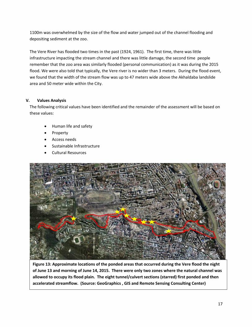
Figure 13: Approximate locations of the ponded areas that occurred during the Vere flood the night of June 13 and morning of June 14, 2015. There were only two zones where the natural channel was allowed to occupy its flood plain. The eight tunnel/culvert sections (starred) first ponded and then accelerated streamflow. (Source: GeoGraphics , GIS and Remote Sensing Consulting Center)
17
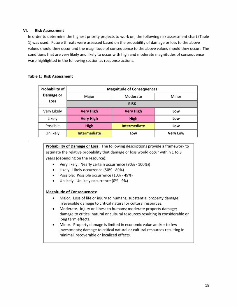
VI. Risk Assessment In order to determine the highest priority projects to work on, the following risk assessment chart (Table 1) was used. Future threats were assessed based on the probability of damage or loss to the above values should they occur and the magnitude of consequence to the above values should they occur. The conditions that are very likely and likely to occur with high and moderate magnitudes of consequence ware highlighted in the following section as response actions.
Table 1: Risk Assessment
Probability of Damage or
Loss
Magnitude of Consequences
Major Moderate Minor
RISK
Very Likely Very High Very High Low
Likely Very High High Low
Possible High Intermediate Low
Unlikely Intermediate Low Very Low
. Probability of Damage or Loss: The following descriptions provide a framework to estimate the relative probability that damage or loss would occur within 1 to 3 years (depending on the resource):
• Very likely. Nearly certain occurrence (90% - 100%)) • Likely. Likely occurrence (50% - 89%) • Possible. Possible occurrence (10% - 49%) • Unlikely. Unlikely occurrence (0% - 9%)
Magnitude of Consequences:
• Major. Loss of life or injury to humans; substantial property damage; irreversible damage to critical natural or cultural resources.
• Moderate. Injury or illness to humans; moderate property damage; damage to critical natural or cultural resources resulting in considerable or long term effects.
• Minor. Property damage is limited in economic value and/or to few investments; damage to critical natural or cultural resources resulting in minimal, recoverable or localized effects.
18
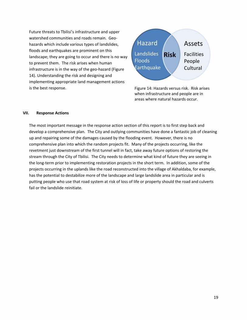
Future threats to Tbilisi’s infrastructure and upper watershed communities and roads remain. Geo-hazards which include various types of landslides, floods and earthquakes are prominent on this landscape; they are going to occur and there is no way to prevent them. The risk arises when human infrastructure is in the way of the geo-hazard (Figure 14). Understanding the risk and designing and implementing appropriate land management actions is the best response.
VII. Response Actions The most important message in the response action section of this report is to first step back and develop a comprehensive plan. The City and outlying communities have done a fantastic job of cleaning up and repairing some of the damages caused by the flooding event. However, there is no comprehensive plan into which the random projects fit. Many of the projects occurring, like the revetment just downstream of the first tunnel will in fact, take away future options of restoring the stream through the City of Tbilisi. The City needs to determine what kind of future they are seeing in the long-term prior to implementing restoration projects in the short term. In addition, some of the projects occurring in the uplands like the road reconstructed into the village of Akhaldaba, for example, has the potential to destabilize more of the landscape and large landslide area in particular and is putting people who use that road system at risk of loss of life or property should the road and culverts fail or the landslide reinitiate.
Figure 14: Hazards versus risk. Risk arises when infrastructure and people are in areas where natural hazards occur.
Assets Hazard
Risk Facilities People Cultural
Landslides Floods Earthquake
19

Throughout the following section the areas highlighted in Figure 15 below will be referred to.
Below are Response Actions recommended to reduce the impact of future flood flow events. Response actions proposed in the following section will be highlighted as either immediate, mid-term, or long-term and separated as appropriate for the : 1. entire Vere River Watershed; 2. Vere River within the City of Tbilisi; 3. Ukankhevi sub-watershed; or 4. upper watershed of the Vere River as depicted in Figure 15 above. We have tried to characterize the response actions by the potential risk and magnitude of consequence if it is not implemented. A relative risk reduction rating for each response action is identified to help prioritize implementation. Finally, the pros and cons of each response action are highlighted. This is simplified in Table 2 and discussed in a bit more detail by project following the table. Benefit Cost (BC) Analysis: The U.S. Environmental Protection Agency’s Guidelines for Preparing Economic Analyses establish a sound scientific framework for performing economic analyses of
Figure 15: Location of site evaluations and proposed response actions in the Vere River Watershed.
Akhaldaba
Ukhankhevi River
Watershed
Electricity Sub-station and Water Supply Plant
Tbilisi – Potential Stream Restoration
20
environmental regulations and policies. They incorporate recent advances in theoretical and applied work in the field of environmental economics. The Guidelines provide guidance on analyzing the benefits, costs, and economic impacts of regulations and policies, including assessing the distribution of costs and benefits among various segments of the population (source: Excerpt from US Environmental Protection Agency). When considering options, it is important to consider all the benefits and all the costs gained from every decision. It is recommended that a BC analysis be completed on the long term environmental impact to not doing anything in the watershed compared to the costs of improved natural stream processes. A BC analyses is an engagement with society on the value of the natural world and it’s an opportunity to bring out the intangible benefits that people do not normally consider. There are typically savings that can be captured by allowing natural systems to operate and not trying to engineer solutions. Examples of intangible benefits include: increased tourism; enhanced quality of life, biodiversity, wildlife sightings, and community bonding. While any consultant can do this analysis process it's actually very difficult to do a good analysis. Tbilisi is growing and this growth can be managed with a good plan which will allow the City to attain its full potential.
21
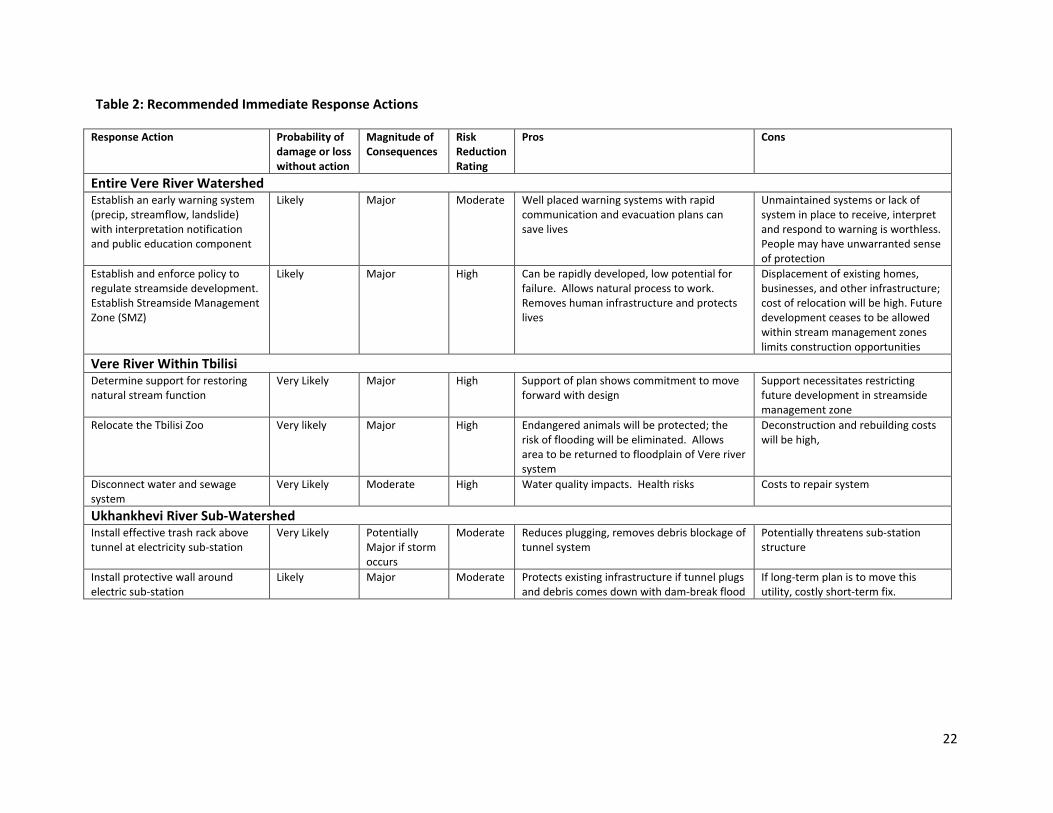
Table 2: Recommended Immediate Response Actions
Response Action Probability of damage or loss without action
Magnitude of Consequences
Risk Reduction Rating
Pros Cons
Entire Vere River Watershed Establish an early warning system (precip, streamflow, landslide) with interpretation notification and public education component
Likely Major Moderate Well placed warning systems with rapid communication and evacuation plans can save lives
Unmaintained systems or lack of system in place to receive, interpret and respond to warning is worthless. People may have unwarranted sense of protection
Establish and enforce policy to regulate streamside development. Establish Streamside Management Zone (SMZ)
Likely Major High Can be rapidly developed, low potential for failure. Allows natural process to work. Removes human infrastructure and protects lives
Displacement of existing homes, businesses, and other infrastructure; cost of relocation will be high. Future development ceases to be allowed within stream management zones limits construction opportunities
Vere River Within Tbilisi Determine support for restoring natural stream function
Very Likely Major High Support of plan shows commitment to move forward with design
Support necessitates restricting future development in streamside management zone
Relocate the Tbilisi Zoo Very likely Major High Endangered animals will be protected; the risk of flooding will be eliminated. Allows area to be returned to floodplain of Vere river system
Deconstruction and rebuilding costs will be high,
Disconnect water and sewage system
Very Likely Moderate High Water quality impacts. Health risks Costs to repair system
Ukhankhevi River Sub-Watershed Install effective trash rack above tunnel at electricity sub-station
Very Likely Potentially Major if storm occurs
Moderate Reduces plugging, removes debris blockage of tunnel system
Potentially threatens sub-station structure
Install protective wall around electric sub-station
Likely Major Moderate Protects existing infrastructure if tunnel plugs and debris comes down with dam-break flood
If long-term plan is to move this utility, costly short-term fix.
22

Table 2 (cont.): Recommended Immediate Response Actions
Response Action Probability of damage or loss without action
Magnitude of Consequences
Risk Reduction Rating*
Pros Cons
Upper Watershed Close main Tskneti Hwy – use alternative route through Kojari until safety and stability of main highway can be assessed
Very Likely Major High Protects life and property. Eliminates putting road contractors at risk during cleanup and reconstruction of road. Eliminates risks to Hwy. users
Long commute time through Kojari
Assess stability of Akhaldaba landslide and adjacent area
Likely Moderate High Determines ability to open Tskneti Hwy. helps decision makers decide how to move forward
None
Use sustainable and safe road construction techniques even for temporary fixes (BMPs)
Likely Moderate High Improved safety of road users, minimizes chance of additional road failures
Costs and time to implement repairs will be increased
*Risk Reduction rating: High: High potential for response action to reduce loss of life or property damage Moderate: Moderate potential for response action to reduce loss of life or property damage Low: Low potential for response action to reduce loss of life or property damage
23
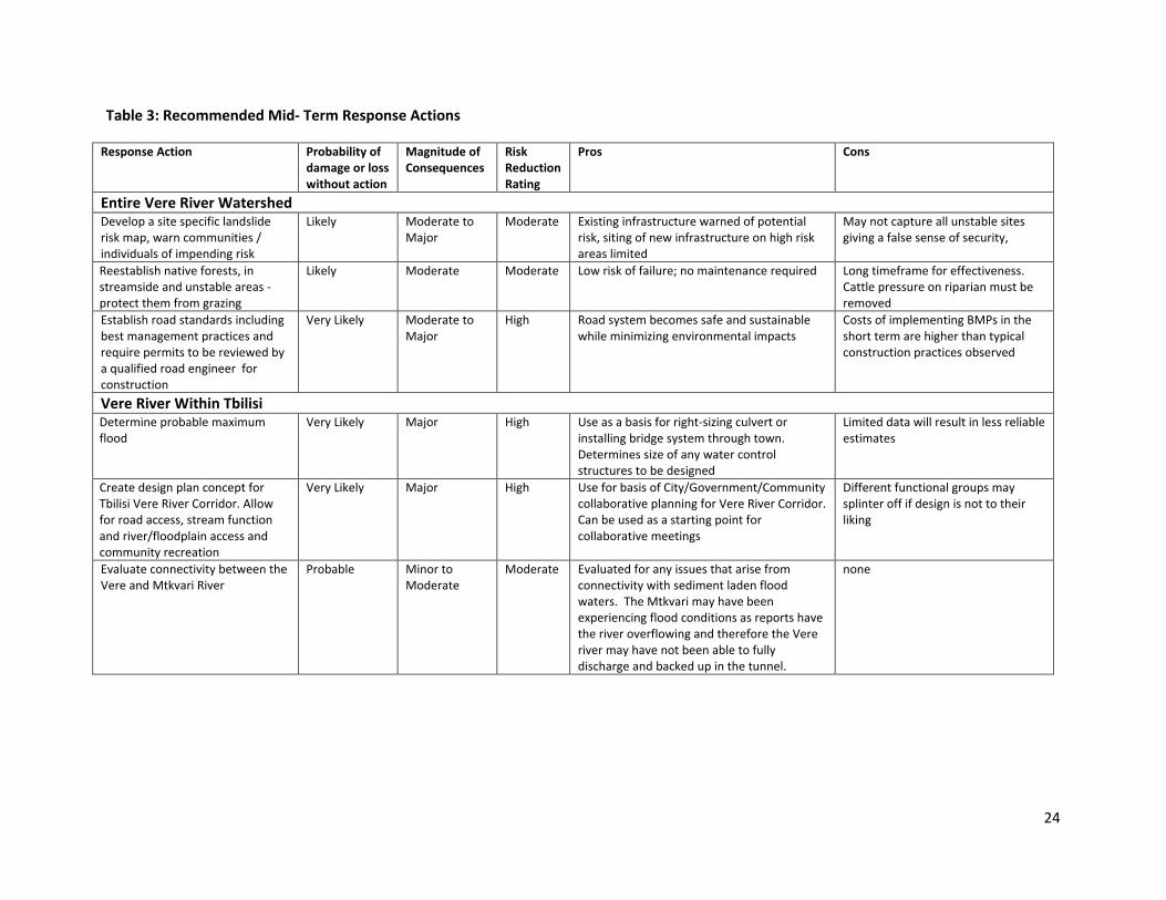
Table 3: Recommended Mid- Term Response Actions
Response Action Probability of damage or loss without action
Magnitude of Consequences
Risk Reduction Rating
Pros Cons
Entire Vere River Watershed Develop a site specific landslide risk map, warn communities / individuals of impending risk
Likely Moderate to Major
Moderate Existing infrastructure warned of potential risk, siting of new infrastructure on high risk areas limited
May not capture all unstable sites giving a false sense of security,
Reestablish native forests, in streamside and unstable areas - protect them from grazing
Likely Moderate Moderate Low risk of failure; no maintenance required Long timeframe for effectiveness. Cattle pressure on riparian must be removed
Establish road standards including best management practices and require permits to be reviewed by a qualified road engineer for construction
Very Likely Moderate to Major
High Road system becomes safe and sustainable while minimizing environmental impacts
Costs of implementing BMPs in the short term are higher than typical construction practices observed
Vere River Within Tbilisi Determine probable maximum flood
Very Likely Major High Use as a basis for right-sizing culvert or installing bridge system through town. Determines size of any water control structures to be designed
Limited data will result in less reliable estimates
Create design plan concept for Tbilisi Vere River Corridor. Allow for road access, stream function and river/floodplain access and community recreation
Very Likely Major High Use for basis of City/Government/Community collaborative planning for Vere River Corridor. Can be used as a starting point for collaborative meetings
Different functional groups may splinter off if design is not to their liking
Evaluate connectivity between the Vere and Mtkvari River
Probable Minor to Moderate
Moderate Evaluated for any issues that arise from connectivity with sediment laden flood waters. The Mtkvari may have been experiencing flood conditions as reports have the river overflowing and therefore the Vere river may have not been able to fully discharge and backed up in the tunnel.
none
24

Table 3 (cont.): Recommended Mid- Term Response Actions
Response Action Probability of damage or loss without action
Magnitude of Consequences
Risk Reduction Rating
Pros Cons
Ukhankhevi Sub-Watershed Remove Rockfall above electricity sub-station
Likely Major Low to Moderate
Removes potential for dam-break flood associated with current rockfall
Rockfall may continue from area above current slide
Stabilize Deep-seated Earthflow above electricity sub-station
Very Likely Major Low to Moderate
Removes constant calving of earthflow and undercutting of toe by river.
Earthflow slip plain may be deeper that feasibly buttressed in stream channel. Engineered structure may fail
Grade control structure, electrical watershed
Likely Major Moderate:
Reduces the size of landslide likely to affect the electrical substation and downstream communities and infrastructure
Need to ensure proper location and design to be effective. Landslide volume may be reduced but not eliminated. Engineered structure may fail
Upper Watershed Stabilize Landslide at Akhaldaba Remove stability hazards where it threatens life and property. Consider threats to community /lower road
Likely Moderate to Major
Moderate Threats to life and property damage are minimized.
High cost, considerable time commitment depending on technique used
25

Table 4: Recommended Long- Term Response Actions
Response Action Probability of damage or loss without action
Magnitude of Consequences
Risk Reduction Rating
Pros Cons
Entire Vere River Watershed Engage in comprehensive Land use Planning with zoning regulated and enforced
Likely Moderate to major
Moderate to High
Ensures that inherent capability of the land to support different uses is evaluated. Protects life and property from natural hazards
Time consuming and costly to engage governmental agencies, NGOs and communities in plan design
Undertake comprehensive master road management planning
Likely Moderate to Major
High Only needed road system is constructed, road best management practices are adopted as standard procedure. Requires integration of many government agencies to complete
Restricts construction of roads outside of planned areas
Install drainage on all road systems Likely Moderate High Protects road systems from erosion. Reduces peak floods by infiltrating water
Costly to retrofit existing roads with proper drainage
Vere River within Tbilisi Create collaborative holistic design for stream corridor restoration
Likely Major High Support of plan shows commitment to move forward with design
Support necessitates restricting future development in streamside management zone
Implement Vere River corridor restoration in Tbilisi. Size remaining culverts or install bridges to pass maximum possible flood
Likely Major High: Natural stream function restored; provides social benefit and flood damage risk reduction some flooding threat remains, but flood intensity lowered
High cost; displacement of existing homes, businesses and other infrastructure
Ukhankhevi Sub-Watershed Develop and implement plan to move or protect or move the electric sub-station and water supply plant
Likely Major High Ensures long-term sustainability of electricity and water supply from these stations
Expensive, hard to find alternative location
26
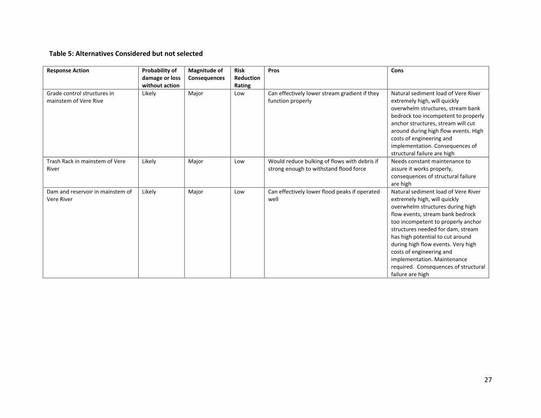
Table 5: Alternatives Considered but not selected
Response Action Probability of damage or loss without action
Magnitude of Consequences
Risk Reduction Rating
Pros Cons
Grade control structures in mainstem of Vere Rive
Likely Major Low Can effectively lower stream gradient if they function properly
Natural sediment load of Vere River extremely high, will quickly overwhelm structures, stream bank bedrock too incompetent to properly anchor structures, stream will cut around during high flow events. High costs of engineering and implementation. Consequences of structural failure are high
Trash Rack in mainstem of Vere River
Likely Major Low Would reduce bulking of flows with debris if strong enough to withstand flood force
Needs constant maintenance to assure it works properly, consequences of structural failure are high
Dam and reservoir in mainstem of Vere River
Likely Major Low Can effectively lower flood peaks if operated well
Natural sediment load of Vere River extremely high, will quickly overwhelm structures during high flow events, stream bank bedrock too incompetent to properly anchor structures needed for dam, stream has high potential to cut around during high flow events. Very high costs of engineering and implementation. Maintenance required. Consequences of structural failure are high
27
Descriptions of Response Actions
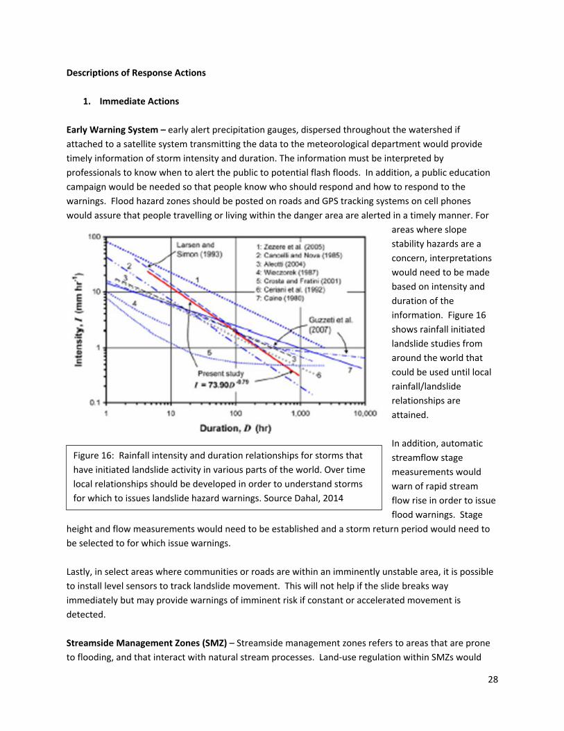
1. Immediate Actions Early Warning System – early alert precipitation gauges, dispersed throughout the watershed if attached to a satellite system transmitting the data to the meteorological department would provide timely information of storm intensity and duration. The information must be interpreted by professionals to know when to alert the public to potential flash floods. In addition, a public education campaign would be needed so that people know who should respond and how to respond to the warnings. Flood hazard zones should be posted on roads and GPS tracking systems on cell phones would assure that people travelling or living within the danger area are alerted in a timely manner. For
areas where slope stability hazards are a concern, interpretations would need to be made based on intensity and duration of the information. Figure 16 shows rainfall initiated landslide studies from around the world that could be used until local rainfall/landslide relationships are attained. In addition, automatic streamflow stage measurements would warn of rapid stream flow rise in order to issue flood warnings. Stage
height and flow measurements would need to be established and a storm return period would need to be selected to for which issue warnings. Lastly, in select areas where communities or roads are within an imminently unstable area, it is possible to install level sensors to track landslide movement. This will not help if the slide breaks way immediately but may provide warnings of imminent risk if constant or accelerated movement is detected. Streamside Management Zones (SMZ) – Streamside management zones refers to areas that are prone to flooding, and that interact with natural stream processes. Land-use regulation within SMZs would
Figure 16: Rainfall intensity and duration relationships for storms that have initiated landslide activity in various parts of the world. Over time local relationships should be developed in order to understand storms for which to issues landslide hazard warnings. Source Dahal, 2014
28

significantly reduce the threat of flooding causing a loss of life and property. The extent of an SMZ is based on site specific conditions, and at a minimum include all areas prone to flooding in a 300 year event (predicted recurrence interval of June 13, 2015 flood). Throughout the Vere River watershed there are multiple examples of where loss of life, property and infrastructure occurred due to infringement on the SMZ. Limited reconnaissance identified the following areas as at risk of loss and/or damage during flood flow events due to their location within the SMZ
• Houses within the village of Akhaldaba • Electrical substation within tributary to Vere River • Houses within Tbilisi • Tbilisi zoo • Cemetery upstream of first culvert/tunnel in Tbilisi
Air reconnaissance found that multiple other structures and dwellings are at risk due to proximity within or immediately adjacent to the SMZ. Development of SMZ boundaries and restriction of development within these boundaries would provide the most significant threat reduction in both losses of human life as well as financial impacts of future floods. All structures currently found within landslide and flood prone areas should be eliminated to the greatest extent possible. SMZ regulation should also control the types of structures allowed within the SMZ. An example of poor
construction was found just upstream of the first tunnel where the Vere River was channelized adjacent to some buildings. The concrete retaining wall did not appear to be tied to either the Vere River insitu rock sidewalls nor embedded into the undying stream-bed. This allowed the wall to be scoured and float up in the stormwater event (Figure 17). Engineered hardened features placed into the stream channel are prone to failure.
Figure 17: Flood caused this poorly constructed concrete retaining wall to float during the flood.
29
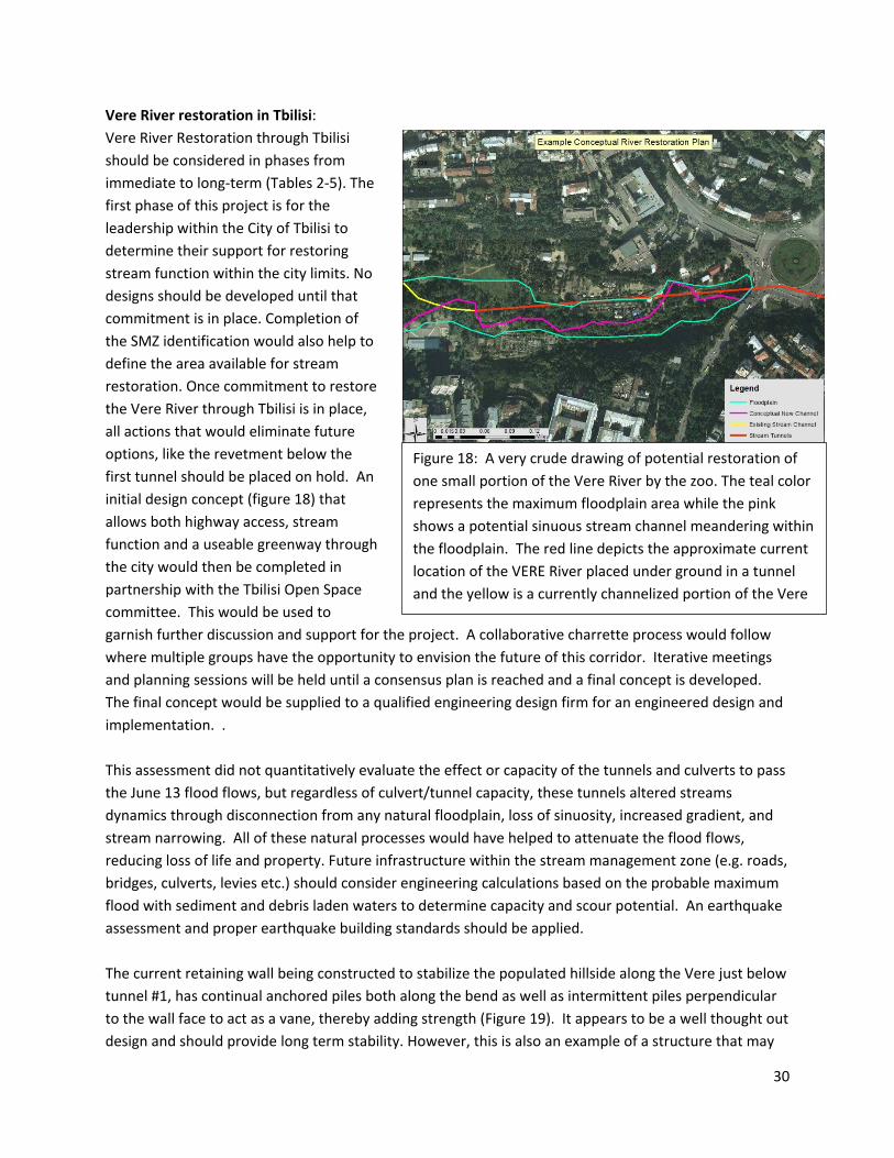
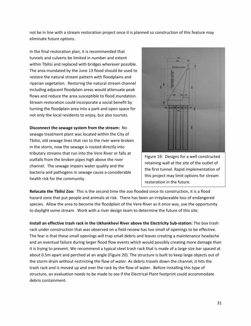
Vere River restoration in Tbilisi: Vere River Restoration through Tbilisi should be considered in phases from immediate to long-term (Tables 2-5). The first phase of this project is for the leadership within the City of Tbilisi to determine their support for restoring stream function within the city limits. No designs should be developed until that commitment is in place. Completion of the SMZ identification would also help to define the area available for stream restoration. Once commitment to restore the Vere River through Tbilisi is in place, all actions that would eliminate future options, like the revetment below the first tunnel should be placed on hold. An initial design concept (figure 18) that allows both highway access, stream function and a useable greenway through the city would then be completed in partnership with the Tbilisi Open Space committee. This would be used to garnish further discussion and support for the project. A collaborative charrette process would follow where multiple groups have the opportunity to envision the future of this corridor. Iterative meetings and planning sessions will be held until a consensus plan is reached and a final concept is developed. The final concept would be supplied to a qualified engineering design firm for an engineered design and implementation. . This assessment did not quantitatively evaluate the effect or capacity of the tunnels and culverts to pass the June 13 flood flows, but regardless of culvert/tunnel capacity, these tunnels altered streams dynamics through disconnection from any natural floodplain, loss of sinuosity, increased gradient, and stream narrowing. All of these natural processes would have helped to attenuate the flood flows, reducing loss of life and property. Future infrastructure within the stream management zone (e.g. roads, bridges, culverts, levies etc.) should consider engineering calculations based on the probable maximum flood with sediment and debris laden waters to determine capacity and scour potential. An earthquake assessment and proper earthquake building standards should be applied. The current retaining wall being constructed to stabilize the populated hillside along the Vere just below tunnel #1, has continual anchored piles both along the bend as well as intermittent piles perpendicular to the wall face to act as a vane, thereby adding strength (Figure 19). It appears to be a well thought out design and should provide long term stability. However, this is also an example of a structure that may
Figure 18: A very crude drawing of potential restoration of one small portion of the Vere River by the zoo. The teal color represents the maximum floodplain area while the pink shows a potential sinuous stream channel meandering within the floodplain. The red line depicts the approximate current location of the VERE River placed under ground in a tunnel and the yellow is a currently channelized portion of the Vere
30
not be in line with a stream restoration project once it is planned so construction of this feature may eliminate future options. In the final restoration plan, it is recommended that tunnels and culverts be limited in number and extent within Tbilisi and replaced with bridges wherever possible. The area inundated by the June 13 flood should be used to restore the natural stream pattern with floodplains and riparian vegetation. Restoring the natural stream channel including adjacent floodplain areas would attenuate peak flows and reduce the area susceptible to flood inundation. Stream restoration could incorporate a social benefit by turning the floodplain area into a park and open space for not only the local residents to enjoy, but also tourists. Disconnect the sewage system from the stream: No sewage treatment plant was located within the City of Tbilisi, old sewage lines that ran to the river were broken in the storm, now the sewage is routed directly into tributary streams that run into the Vere River or falls at outfalls from the broken pipes high above the river channel. The sewage impairs water quality and the bacteria and pathogens in sewage cause a considerable health risk for the community. Relocate the Tbilisi Zoo: This is the second time the zoo flooded since its construction, it is a flood hazard zone that put people and animals at risk. There has been an irreplaceable loss of endangered species. Allow the area to become the floodplain of the Vere River as it once was, use the opportunity to daylight some stream. Work with a river design team to determine the future of this site. Install an effective trash rack in the Ukhankhevi River above the Electricity Sub-station: The box trash rack under construction that was observed on a field review has too small of openings to be effective. The fear is that these small openings will trap small debris and leaves creating a maintenance headache and an eventual failure during larger flood flow events which would possibly creating more damage than it is trying to prevent. We recommend a typical steel trash rack that is made of a large size bar spaced at about 0.5m apart and perched at an angle (Figure 20). The structure is built to keep large objects out of the storm drain without restricting the flow of water. As debris travels down the channel, it hits the trash rack and is moved up and over the rack by the flow of water. Before installing this type of structure, an evaluation needs to be made to see if the Electrical Plant footprint could accommodate debris containment.
Figure 19: Designs for a well constructed retaining wall at the site of the outlet of the first tunnel. Rapid implementation of this project may limit options for stream restoration in the future.
31

Install a protective wall around the electric sub- station: The electrical plant is located in a high hazard risk area and although it would be best to move the infrastructure out of the area completely it may not be feasible therefor building a protective perimeter wall around the electrical plant’s most valuable asset while allowing a debris and flood path may be of value. Close the main Tskneti Hwy until a thorough geotechnical analysis can confirm the stability of the Akhaldaba landslide area: Closing the highway reduces the liability of traffic traveling through an unstable area. The existing road through Kojari provides access to the communities above the landslide but increased the travel time by three fold, from 20 minutes to over an hour, depending on traffic. While the road is closed a geotechnical assessment of the slide area (outlined below) should proceed. Even cleaning the debris from the old Tskneti Hwy road prism puts the equipment operators at risk. Assess stability of the Akaldaba landslide and surrounding area: While the main Tskneti Highway remains closed by debris, the Tskneti-Akhaldaba Road has been reopened by local contractors. The Tskneti-Akhaldaba Road is at a high risk for a catastrophic event and is the only access to the Akhaldaba village. In addition to the landslide area itself, the top and sides of the Akhaldaba landslide have large cracks and show signs of potential future slide activity. The entire area will be highly unstable in the next large rainfall event. The loose soil and rock debris, once saturated, is prone to sliding since many of the slopes below were over-steepened by the last event. The Akhaldaba landslide should have a thorough geotechnical assessment to determine where the landslide is stable and where it is not. Various methodologies for stabilizing the landslide should be determined especially before opening the high traffic volume Tskneti Hwy. Following the site investigation, it can be determined if it is safe to open the road with the slide material in place or if opening the road would require removal of all or a portion of the material. Different techniques, such as blasting or scarifying the material should be determined during the investigation. Alternative access routes should also be investigated. An evaluation should be made of the benefits and costs of opening the hazardous slide area to traffic or enhancing the existing back road and providing an access point that's palatable to the community. The geotechnical investigation will help decision makers determine the best course of action with which to proceed. Use Proper Road Construction techniques and Best Management Practices (BMPs) even for temporary construction: We are leaving two electronic documents that will assist with determining proper road construction techniques (Low Volume Road Engineering and Storm Damage Risk Reduction Guidebook).
Figure 20: A trash rock that allows coarse debris to pass over the tunnel opening and not cause blockage. (photo from Port Costa Reservoir)
32

These are most useful for rural roads, not highways, although many of the same principles apply for both. Use of these manuals in planning and designing the roads system will greatly reduce maintenance costs, losses to the road infrastructure and damage to the environment. The following are some of the poor road construction actions that were seen on the Tskneti – Akhaldaba road reconstruction:
• Side casting: Sidecasting is the pushing of loose material over the side of the road toward the downward slope. This practice adds weight to the outer edge and that weight and loose material has the potential to create its own slide. Loose material should be placed in a dump truck and transported to a place that is stable to store it.
• No compaction of fill: This is a must. There are ways to achieve relative compaction by rolling with heavy equipment in lifts no thicker than 12" until the roadway is not yielding. Roadbuilding starts at the bottom with competent material, if you encounter soft wet or unsuitable materials such as clay the material is excavated out or bridged with competent material.
• Poor culvert placement and alignment: Stream crossings need to be adequately spanned to allow the stream flow to pass through a culvert or under a bridge. Culverts need to be seated in the earth so that the stream flow goes through them not under or around them as was seen several times. Sufficient fill should be placed and compacted over the tip of the culvert to ensure that heavy equipment (e.g. water trucks) do not squash the pipe and tip over.
• Lack of road drainage. Cross drains or water bars need to be installed to protect the road surface. Drainage inlet and outlet protection with energy dissipation at the outfall will minimize erosion downslope and further destabilization of the land. Storm water outfalls should be rocked or vegetated. Vegetation provides areas for catchment, tall grasses can holdback sediment and stabilize the earth.
33
2. Mid-Term Response Actions Develop a site specific Landslide Risk Map: Understanding the inherent instability of the landscape is core knowledge that should be used in any land management plan. Inherent instability is different from just mapping existing landslides. Landslides reactivate within the limits of unstable landscapes. It is impossible to tell when or exactly where they may occur, however, it is possible to reduce the risk of the landslide impacting infrastructure or causing loss of life if the boundaries of the unstable areas are known in advance. Land use planning and site selection for development can then be zoned to restrict development in high hazard areas. The LiDar imagery that will be acquired by the MENRP will be a great starting point for landslide risk mapping. In addition, field reconnaissance will be required to confirm any risk models that are created. Even with the best staff and competent field work, some unstable sites may be missed potentially giving a false sense of security to people living outside of mapped areas. Reestablish Native forests adjacent to streams and in unstable areas: Field observations found multiple locations where cottonwood trees on the terraces adjacent to the Vere River captured woody and other debris including steel beams (Figure 8). The magnitude of the June 13 floods mobilized and transported extensive quantities of woody debris. It is recommended that reforestation of cottonwoods on stream terraces throughout the mainstem of the Vere River be initiated to grow cottonwood trees that would act to capture debris during flood flow events. Field reconnaissance also revealed that young cottonwoods were not part of the riparian vegetation probably due to grazing pressure which removes young riparian trees and shrubs from the system. Any planting sites should be protected from livestock. The effectiveness of this treatment will be delayed until the cottonwood trees mature, but once mature, the cottonwoods would be self-maintaining debris racks with low potential for failure during flood flow events. Stream adjacent slopes and unstable areas should also be reforested as needed to restore the landscapes natural ability to lower the flood peak by accepting, infiltrating, and storing precipitation and slowly releasing them over time to the stream channel. Establish road construction standards and a permit policy: This is similar to using proper construction techniques except that it requires new legislation and policy to be developed in order to ensure that proper road construction techniques are being utilized. Roads can currently be constructed anywhere and it is the equipment operator who usually determines the location and construction techniques. Many roads were seen to run perpendicular to the contour and have deep gulleys in them. No road drainage structures were seen on any road travelled or visited. Inboard ditches ran for miles without cross drains to relieve the pressure and quantity of water. Requiring standards for road construction, and permits that are reviewed by a qualified engineer will prevent a lot of road construction errors and reduce the impact of the road system on the environment. Qualified inspectors need to be on-site during construction to assure that the plans and construction standards are being met. Determine Probable Maximal Flood (PMF): The PMF is the largest flood that could conceivably occur at a particular location, usually estimated from probable maximum precipitation and, where applicable, snow melt, coupled with the worst flood producing catchment conditions. Generally, it is not physically
34

or economically possible to provide complete protection against this event. The PMF defines the extent of flood prone land, that is, the floodplain. The extent, nature and potential consequences of flooding associated with a range of events rarer than the flood used for designing mitigation works and controlling development, up to and including the PMF event should be addressed in a floodplain risk management study (http://www.hurstville.floodstudy.com.au/index.php/component/glossary/Glossary-1/P/Probable-Maximum-Flood-(PMF)-47/) The maximum probable flood will need to be accommodated through a series of tunnels and confined waterways, due to urban development. This becomes challenging. Therefore development of access to flood and debris containment areas using the historic floodplain area should be incorporated into the restoration design. Culverts and tunnels should be removed and replaced by bridges wherever possible. Future infrastructure within the floodplain, i.e. roads, bridges, culverts, levies should all consider engineering calculations based on the maximum probable flood with sediment laden waters for capacity and scour as well as a probable earthquake analyses. Any structures placed in the floodplain remove flow capacity. Remove the rockfall in Ukhankhevi River above electricity sub-station:
The slide area just upstream of the Electrical Plant poses another very difficult problem due to the narrow ravine for access. Evaluate the engineering feasibility of removing the rock slide and building a buttress at the toe with rock. It appears to be feasible to bring a road in from the top by the power lines to first topple and then remove the rock slide material until the bankfull width of the stream channel is attained and the slide is buttressed and stable. A stable storage area for the rock that is removed will need to be found. If the rock is suitable for construction projects, it could be sold. Stabilize the deep-seated earthflow in Ukhankhevi River: The existing large rotational failure is perched directly above the Ukhankhevi River and as it moves
downslope, the toe is constantly undercut by the river causing sloughing of the cracked blocks of soil at
Figure 21: A simple rock filled buttress to increase slope stability using gabion or a rock roll which are flexible ‘sausages’ of crushed rock that are place embedded into the bank toe to prevent undercutting and fluvial scour.
35
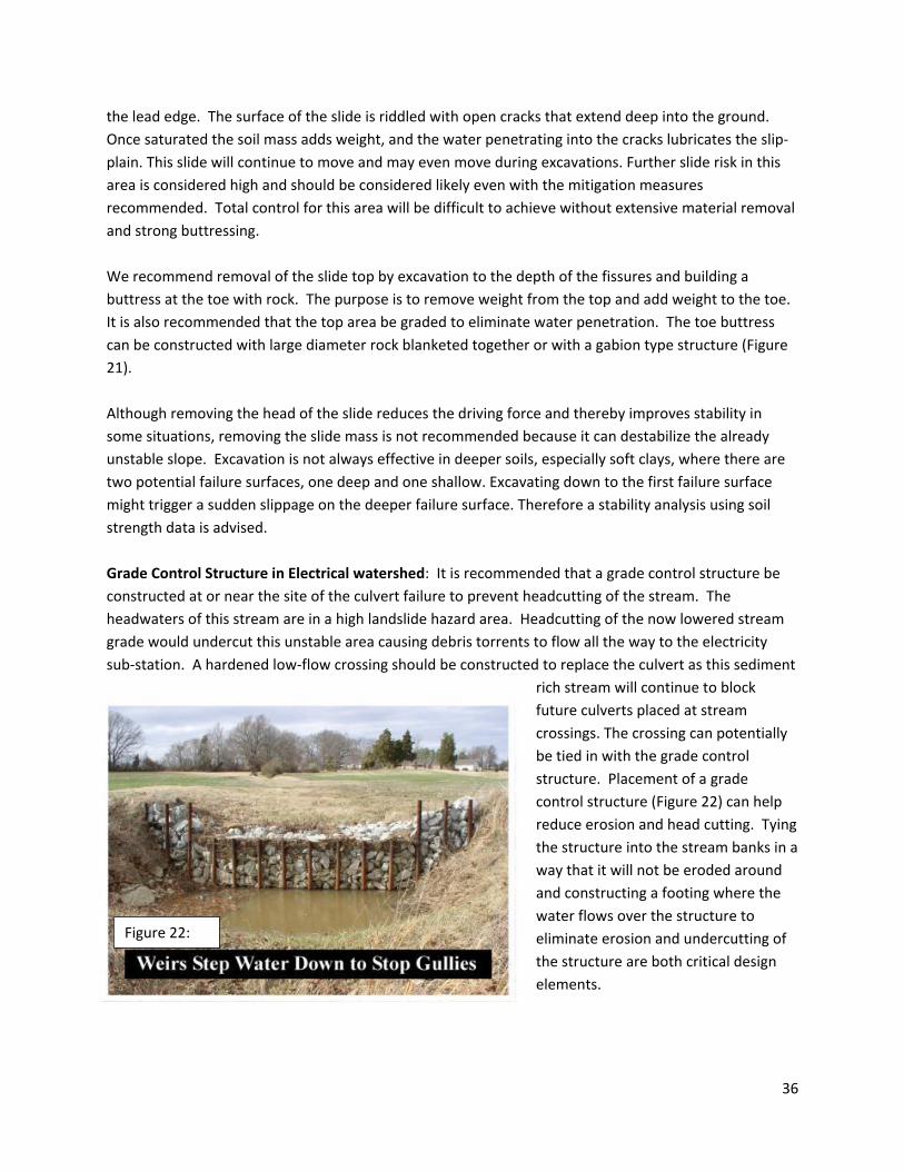
the lead edge. The surface of the slide is riddled with open cracks that extend deep into the ground. Once saturated the soil mass adds weight, and the water penetrating into the cracks lubricates the slip- plain. This slide will continue to move and may even move during excavations. Further slide risk in this area is considered high and should be considered likely even with the mitigation measures recommended. Total control for this area will be difficult to achieve without extensive material removal and strong buttressing. We recommend removal of the slide top by excavation to the depth of the fissures and building a buttress at the toe with rock. The purpose is to remove weight from the top and add weight to the toe. It is also recommended that the top area be graded to eliminate water penetration. The toe buttress can be constructed with large diameter rock blanketed together or with a gabion type structure (Figure 21). Although removing the head of the slide reduces the driving force and thereby improves stability in some situations, removing the slide mass is not recommended because it can destabilize the already unstable slope. Excavation is not always effective in deeper soils, especially soft clays, where there are two potential failure surfaces, one deep and one shallow. Excavating down to the first failure surface might trigger a sudden slippage on the deeper failure surface. Therefore a stability analysis using soil strength data is advised. Grade Control Structure in Electrical watershed: It is recommended that a grade control structure be constructed at or near the site of the culvert failure to prevent headcutting of the stream. The headwaters of this stream are in a high landslide hazard area. Headcutting of the now lowered stream grade would undercut this unstable area causing debris torrents to flow all the way to the electricity sub-station. A hardened low-flow crossing should be constructed to replace the culvert as this sediment
rich stream will continue to block future culverts placed at stream crossings. The crossing can potentially be tied in with the grade control structure. Placement of a grade control structure (Figure 22) can help reduce erosion and head cutting. Tying the structure into the stream banks in a way that it will not be eroded around and constructing a footing where the water flows over the structure to eliminate erosion and undercutting of the structure are both critical design elements.
Figure 22:
36

Stabilize landslide at Akhaldaba: The Tskneti-Highway Road and the Tskneti-Akhaldaba Road traversed the area and were both damaged by the landslide. A good solution may be to abandon the main Tskneti Highway, the geotechnical analysis (immediate response action section) should look at potential alternative routes and determined if these roads are in the immediate landslide hazard zone. Stabilization of this landslide will likely require removal of loose debris material from the failed slope also above and to the sides. Debris removal should occur from the top-down. The area of the slide zone will need to be scraped of loose slide debris and any weak material. This may be safer than blasting due to the weathered nature of the rock. The surface could probably be ripped with the right backhoe attachment. Blasting has the potential to fracture more of the bedrock in the surrounding area thereby destabilizing more of the slope. Standard construction techniques would not clean up the slide debris from the middle of the slide area due to instability issues. Excavation would start at the top by crossing the slope in sections building your way in and removing the material by scarifying the unstable material. All this waste material would then be transported off site to a stable location. This is a time consuming operation. A geotechnical engineer is critical to the success of this project. Anticipated costs are a few million dollars.
3. Long-Term Response Actions Engage in Comprehensive Land Use Planning Land use planning accompanied by zoning regulations and mapping is essential for the future prosperity of the Tbilisi area. Land use planning and regulations are necessary to prevent further development in unstable and flood prone areas. Undertake comprehensive master road management planning A master road management plan determines, ahead of development, where all road systems will be necessary and minimizes unnecessary duplication of roads for the next 20 years. The long-range plan determines transportation investments. The plan incorporates the vision of the community into an integrated and efficient land use and transportation system that addresses the multi-modal desires of the community. A master plan identifies unstable and flood prone areas and restricts development in those areas. It is a critical component of land use planning. Once completed, unneeded roads can be abandoned, re-contoured and restored allowing both water infiltration and re-vegetation to occur. Creating a tool box of best management practices is highly recommended. These include roadbed gradation, compaction, and storm water control measures.
37

Install drainage on all road systems Designing roads systems with proper drainage is one of the most critical best management practices to both protect the integrity of the road system and to protect from soil erosion and landslides. It is much less expensive to incorporate drainage during initial construction than to retrofit existing systems. No functioning road drainage systems were observed during our field visit. Even the newly constructed Chabua Amirejibi motorway has no storm drain control. There are many components to road drainage, including determining the shape of the road (Figure 23), incorporating cross drains, determining appropriate spacing and sizing the drainage features based on anticipated storm and flow events. Although the watershed get just over 500mm of rain a year, storm drainage should be designed for the typical high intensity short duration storm that is likely to cause driving hazards and environmental damage. Develop and implement a plan to move or protect the electric sub-station There is an electric sub-station and water supply plant that sit over the Ukhankhevi River and two other tributaries. With the unstable lands in all of these drainages, these utilities are at risk of being inundated by a dam break flood. There is already a 2 meter wide hole in the middle of the power station where piping of the base is presently occurring probably due to piping around the tunnel. The City should consider moving these utilities to more stable locations. Connectivity between the Vere and Mtkvari may need to be evaluated for any issues that arise from connectivity with sediment laden flood waters. The Mtkvari may have been experiencing flood conditions, as reports have the river overflowing, and therefore the Vere river may have not been able to fully discharge and backed up in the tunnel.
VIII. Conclusions The impacts of the 2015 Vere River flood through the City of Tbilisi could have been less severe with proper planning. There is now an opportunity to plan the future of the city and surrounding communities. This can be accomplished through the development of a comprehensive restoration and land use plan. This must include legislation to regulate development and growth and to protect streams. In recovering from the flood, there is an opportunity to use green infrastructure to restore watershed conditions, improve the resiliency of the system, reduce peak flows and create a livable community.
Figure 23: Schematic of various road surface shapes that shed water.
38
References CENN, 2015, Regarding the causes of the disastrous Vere River flood, Caucasus Environmental NGO Network, Tblisi Georgia, June 17, 2015 www.CENN.org
National Environment Agency, 2015, General Analysis of Threats of Natural Disasters on the Territory of Tbilisi and Preliminary Assessment of the Situation Created after the Disaster that Developed in Riv. Vere Catchment Area, National Environmental Agency, Ministry of Environment and Natural Resources Protection of Georgia, June 2015
39


