Initial Environmental Examination - Asian Development …€¦ · · 2014-10-03The initial...
84
The initial environmental examination is a document of the borrower. The views expressed herein do not necessarily represent those of ADB’s Board of Directors, Management, or staff, and may be preliminary in nature. Initial Environmental Examination Document Stage: Draft for Consultation Project Number: 43464 MAY 2011 India: Himachal Pradesh Clean Energy Transmission Investment Programme Tranche 1 Prepared by HP Power Transmission Corporation Limited (HPPTCL)
Transcript of Initial Environmental Examination - Asian Development …€¦ · · 2014-10-03The initial...
The initial environmental examination is a document of the borrower. The views expressed herein do not
necessarily represent those of ADB’s Board of Directors, Management, or staff, and may be preliminary in
nature.
Initial Environmental Examination
Document Stage: Draft for Consultation Project Number: 43464 MAY 2011
India: Himachal Pradesh Clean Energy Transmission Investment Programme
Tranche 1
Prepared by HP Power Transmission Corporation Limited (HPPTCL)
i
Table of Contents ABBREVIATIONS I WEIGHTS AND MEASURES I 1.0 INTRODUCTION 1
1.1 Background 1 1.2 Scope of Work and Methodology Adopted 2 1.3 Applicable Environmental Policies and other Legislations 2
2.0 DESCRIPTION OF THE PROJECT 3 2.1 Type of Project 3 2.2 Category of Project 3 2.3 Need for the Project 5 2.4 Location 5 2.5 Size and Magnitude of the Operation 7 2.6 Implementation Plan 8
3.0 DESCRIPTION OF ENVIRONMENT 17 3.1 Physical Resource 17 3.2 Earthquake Zone: 21 3.3 Ecological Resources 22 3.4 Economic Development 23 3.5 Social and Cultural Development 28
4.0 SCREENING OF POTENTIAL ENVIRONMENTAL IMPACT AND MITIGATION MEASURES 29
4.1 Route Selection 29 4.2 Environment Impacts and Mitigation Measures 34 4.3 Environmental Management Plan 42
5.0 INSTITUTIONAL REQUIREMENTS AND ENVIRONMENTAL MONITORING PROGRAMME 46
5.0 Institutional Arrangements 46 5.1 Environmental Monitoring Plan 49 5.2 Critical Environmental Review Criteria 50 5.3 Environmental Management Plan Budget Costs 50 5.4 Associated Facilities 51 5.5 Health and Safety Management 52
6.0 PUBLIC CONSULTATION AND INFORMATION DISCLOSURE 52 6.1 Information Disclosure 52 6.2 Public Consultation 53 6.3 Consultation Findings 53
7.0 GRIEVANCE REDRESS MECHANISM 54 8.0 FINDINGS AND RECOMMENDATIONS 55 9.0 CONCLUSIONS 57 ANNEX 1 APPLICABLE RULES, REGULATION, POLICIES AND PROCEDURES 58 ANNEX 2 INVENTORISATION DETAILS OF HATKOTI – GUMMA TRANSMISSION LINE 60 ANNEX 3 ENVIRONNENT MANAGEMENT PLAN (EMP) 64 ANNEX 4 ENVIRONMENTAL MONITORING PLAN 71 ANNEX 5 DETAILS OF PUBLIC CONSULTATIONS 74
i
ABBREVIATIONS
ADB – Asian Development Bank CEA – Central Environmental Authority DC or D/C – Double Circuit DPR – Detailed Project Report EA – Executing Agency EARF – Environmental Assessment and Review Framework EIA – Environmental Impact Assessment EMoP – Environmental Monitoring Plan EMP – Environmental Management Plan EHV – Extra High Voltage ESC – Environment and Social Cell GHG – Green House Gas GOHP – Government of Himachal Pradesh GoI – Government of India GRM – Grievance Redress Mechanism HP – Himachal Pradesh HPCEDIP – HP Clean Energy Development Investment Program HPCETIP – Himachal Pradesh Clean Energy Transmission Investment Program HPSPCB – HP State Pollution Control Board HPPCL – HP Power Corporation Limited HPPTCL – HP Power Transmission Corporation Limited HPSEB – Himachal Pradesh State Electricity Board IA – Implementing Agency IEE – Initial Environmental Examination LILO – Line – in- Line- out MFF – Multi-tranche Financing Facility MOEF – Ministry of Environment and Forests, Government of India PCB – Poly Chlorinated Biphenyl PGCIL – Power Grid Corporation of India Limited PMU – Project Management Unit ROW – Right of Way RP – Resettlement Plan SF6 – Sulphur Hexafluoride
WEIGHTS AND MEASURES
ha (hectare) – Unit of area km (kilometer) – 1,000 meters kV – kilovolt (1,000 volts) kW – kilowatt (1,000 watts) kWh – kilowatt-hour MW – Mega Watt MU – Million Units
1
1.0 INTRODUCTION 1. Himachal Pradesh is a North Indian mountainous state. The climate of the state varies from subtropical in valleys to temperate on higher slopes. The total area of Himachal Pradesh is 55,663 sq. km, which is 1.74% of the total area of India. The state is very rich in natural resources specially forest and water, as it has many glaciers, dense forests, mountain peaks and a network of rivers - Satluj, Beas, Ravi, Chenab, Pabbar etc. A total of 84.5% of the area is under forest cover. The outer and lesser Himalayan watersheds of the state covering 28,970 sq. km area are of great national importance, as entire northern India depends largely for water and power produced by runoff from this region. Himachal Pradesh extends from the Shivalik Hills in the south to the Great Himalayan ranges including a slice of trans-Himalayas in the north. 2. For improvement, strengthening of existing and building of new infrastructure for effective power evacuation, the Government of Himachal Pradesh (GoHP) through the Government of India (GoI), has requested the Asian Development Bank (ADB) for a Multi- Tranche Financing Facility (MFF) to part finance the power sector investment program in the state. The investment program covers investments for transmission of clean energy to National Grid of India by construction of pooling substations and EHV transmission lines. 3. Himachal Pradesh Government established HP Power Transmission Corporation Limited (HPPTCL) vide HP Government Notification No.: MPP-A (1)-4/2006-Loose dated 11th September, 2008 as the State Transmission Utility (STU):
1.1 Background 4. The $350 million investments in the Multi Tranche Financing Facility (MFF) to be supported by Asian Development Bank (ADB), will contribute to economic development in Himachal Pradesh through expanded power supplies from clean energy sources, and support a sustainable state electricity sector in the state. The Himachal Pradesh Clean Energy Transmission Investment Program (HPCETIP) will produce the following outcomes: (i) increase availability of clean energy downstream at pooling stations for effective power evacuation in a financially sustainable manner, (ii) improve state finances and power sector financial viability from sales revenue earned from power exports, (iii) improve sector governance, (iv) improve capacity in HP Power Transmission Corporation Limited (HPPTCL) for better planning, implementation and management of power evacuation infrastructure, and energy efficiency through a better power management program, and (v) Improvement in standards of environmental and social safeguards in the sector. With ADB support, the proposed program will sustain the energy sector reform agenda, and is expected to help attract other long-term financiers to the state.
5. The proposed Tranche 1 Project, located in Kinnaur and Shimla districts of Himachal Pradesh, consists of the following components: Power transmission line: One 28 km long 220 kV double circuit twin moose conductor
transmission line between Hatkoti - Gumma (Pragati Nagar) in District Shimla. This line will evacuate 111 MW power from Sawra Kuddu HEP funded by ADB’s HP Clean Energy Development Investment Program (HPCEDIP) for HP Power Corporation Limited (HPPCL). This line will connect to proposed Hatkoti 220 kV switching station and terminate at the proposed 400/220 kV pooling substation at Gumma (Pragati Nagar).
EHV Pooling Substations: Three extra high voltage (EHV) pooling substations (i) 400/220 kV Pooling station Gumma (Pragati Nagar) (ii) 400/220/66 kV Pooling station at Sherpa Colony (Wangtoo), and (iii) 220/66 kV Pooling station at Bhoktoo. These projects will pool power from Satluj and Pabbar river basins and jointly evacuate three power projects being funded by ADB’s HPCEDIP – Sawra Kuddu (111 MW), Kashang (243 MW) and Shongtong Karchham (450 MW) for HP Power Corporation Limited (HPPCL).
Capacity Building and Training: HPPTCL, established on 11th September, 2008, has been hiring seconded staff from the previously unbundled HP State Electricity Board (HPSEB). To build its own cadre, HPPTCL needs capacity building and skills augmentation through training on technical aspects, study trips and exposure, project management, contracts related conflict resolution, environmental and social assessment, review and monitoring and IT related Enterprise Resource Planning (ERP). More training modules may be added in future
2
depending on new staffing situation.
6. The Tranche 1 sub-projects are estimated to cost US$ 142.30 Million (without IDCs and contingencies). HPPTCL is both the Executive Agency (EA) and implementation Agency for the project, Project Management Unit (PMU), headed by Senior Project Manager (Planning), is established at corporate level located in Shimla who will be assisted by DGMs from various functions – Administration and finance, Planning and design, Procurement and contracts, Environment cell and project construction. Project Implementation Units (PIUs) at divisional level are headed by Executive Engineers at four geographic locations in the state.
1.2 Scope of Work and Methodology Adopted 7. An Initial Environmental Examination (IEE) has been prepared for tranche 1 subprojects funded under HPCETIP. This IEE requires identification of potential environmental issues associated with the Project and appropriate mitigation measures to be put in place to minimize the environmental Impact. The broad scope of the IEE is: i) To conduct field visits to collect data relevant to the study area and also collect secondary
data so as to establish the baseline environmental status of the study area; ii) To assess the impacts on environmental attributes due to the location, design, construction
and operation of the proposed Project; iii) To prepare an Environment Management Plan (EMP) outlining the measures for mitigating
the impacts for protecting the environment including institutional arrangements; iv) To identify critical environmental parameters required to be monitored subsequent to the
implementation of the proposed Project; v) To carry out consultation with local people to identify public perception regarding the
project; and vi) To establish an Environment Monitoring Plan for HPPTCL to submit environmental
monitoring reports to ADB at regular intervals.
8. This IEE report comprises baseline data on existing conditions on physical, ecological, economical and social aspects, together with the anticipated environmental impacts and proposed mitigation measures. Observations were made along the proposed transmission line tower locations, as well as in and around the proposed premises for new substations between February to mid-May 2011. Routes visited were based on the current alignments considered feasible by HPPTCL. The alignment of line may slightly vary after the exact demarcation of tower locations. Field surveys were also undertaken to assess physical and biological environment. Detailed assessment of the baseline environment has been conducted for the entire route of the proposed alignment and data collection from secondary sources has been done to support the findings of the field survey. The field studies were supported by data collected from secondary sources such as Internet, Forest Atlas and published GOIs data from 2001 population census statistics data, as well as from authorities such as HPPTCL, HP State Pollution Control Board (HPSPCB), Forest and other Departments.
9. Public consultations with the project affected communities, stakeholders, and government officers focussed on existing environmental conditions around the proposed transmission lines/ substations and the potential impacts that could happen due to project implementation. Since the HPCETIP does not involve activities that have significant adverse impacts, the present IEE has been prepared to determine the impact of power transmission aspects as per ADB’s Safeguard Policy Statement (SPS) 2009 and Environmental Assessment Guidelines (2003)1. Accordingly, the environmental classification for the Tranche 1 projects is ―Environment Category B‖.
1.3 Applicable Environmental Policies and other Legislations 10. As per Government of India’s (GoI) Environment Impact Assessment (EIA) Act 2009, Power transmission projects are not listed as environmental sensitive projects and hence no
1 ADB 2003: Operations Manual, Environment Policy, Environmental Guidelines for Selected Industrial and Power Projects, and Environmental Assessment Guidelines, Manila.

3
clearance is required from Himachal Pradesh State Pollution Control Board (HPSPCB) or Ministry of Environment and Forests (MoEF), GoI. Clearance from HP Forest Department is required only in cases where subproject is constructed on forest land or requires cutting of forest trees. Moreover, National Environmental Policy 2006 of Government of India (GoI) and Safeguard Policy Statement 2009 of ADB and procedures and guidelines as listed in Appendix 1 thereto apply to all components/subprojects funded by ADB. 11. The Ministry of Environment and Forests, Government of India, vide its Notification No. S.O. 1533 dated 14-09-2006, reengineered the EIA process in India, also decentralized some powers, and made provision to constitute the State Level Environment Impact Assessment Authority (SEIAA) and the State Level Expert Appraisal Committee (SEAC) for performing functions under the said Notification. For the HP State, the SEIAA and SEAC were constituted vide the MoEF, GOI, Notification No. S.O. 1533 dated 14-09-2006. In addition, the Himachal Pradesh State Pollution Control Board's (HPSPCB) guidelines for project proponents apply to all HP state projects. Annex 1 indicates the applicable laws and regulations, with which compliance in part or full is necessary for conduct of the proposed project activities.
2.0 DESCRIPTION OF THE PROJECT 2.1 Type of Project 12. The hydropower generation potential of Himachal Pradesh is about 23,000 MW, which is about one-fourth of the total hydropower potential of India. In its Hydropower Policy (2006)2, the Government of Himachal Pradesh (GOHP) targets its comparative advantage in hydropower with the goal to become the "hydropower state" of the country. The state's hydropower development includes construction of enabling infrastructure such as road access and transmission interconnections to facilitate hydropower development, and to encourage investment from the state, central government and private sectors in hydropower generation projects—the majority of which are run-off-river type. This will improve state finances from sales revenue earned from supplying excess power to the national grid. In addition to developing its hydropower resources, HP must commensurately build out its electric transmission infrastructure so that the additional power can be efficiently transmitted within the state and exported to the national grid. 2.2 Category of Project 13. The comprehensive Power System Master Plan3, completed in December 2010 with ADB assistance, considers transmission requirements in each of HP’s five major river basins where hydropower generation is either being built or planned, with an overarching objective of economic least cost development at appropriate levels of supply security and reliability. This includes overhead transmission line planning, substation equipment planning, and system integration into the National Electricity Plan. 14. The project also includes institutional strengthening initiatives for the state’s power sector entities. Specific to transmission, this includes capacity development objectives for further corporatization of HPPTCL, given the considerable investment plans for additional hydropower and commensurate transmission system investments in HP and HPPTCL’s central role in new transmission system upgrades as an STU. 15. The Tranche 1 of HPTECIP project consists of one transmission line and three pooling substations (details in Table 1). Figure 1 gives the location of each of the projects in the state of Himachal Pradesh. The following sections present each of these components.
Table 1: Tranche 1 Subprojects SNo Name of Work Cost In Million Dollars
1 66/220 kV, 31.5 MVA sub-station at Bhoktoo with LILO of one circuit of 220 kV Kashang- Bhaba double circuit line.
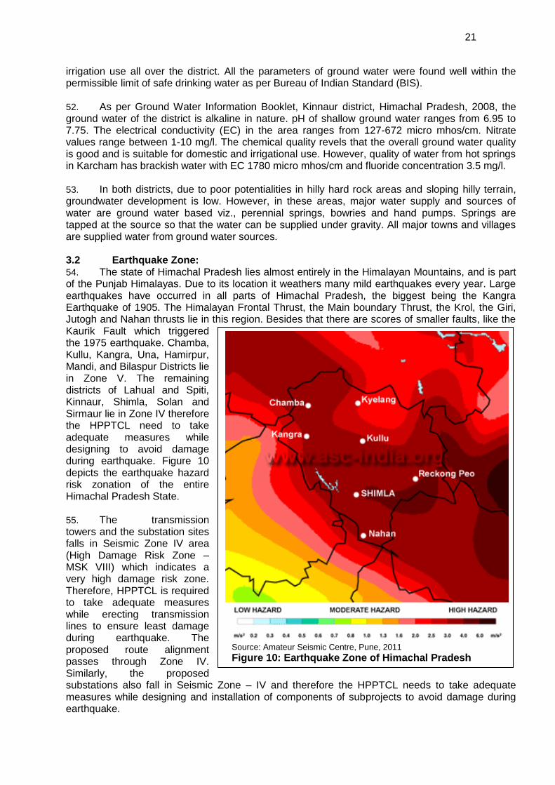
14.4
2 Government of Himachal Pradesh. 2007. Hydro Power Policy (2007). Shimla.
3 Funded under a component of TA 7181-IND: Capacity Building for Himachal Pradesh Power Sector
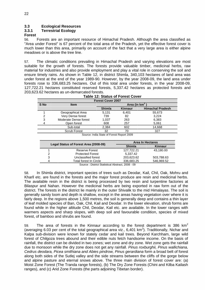
Agencies.
4
2 220 kV D/C (Twin Moose conductor) line from Hatkoti to 220/400 kV Gumma (Pragati Nagar) sub-station
19.4
3 220/400 kV, 1x315 MVA Gumma (Pragati Nagar) substation with LILO of two circuits of 400 kV Jhakri- Abdullapur double circuit line
38.2
4 66/220/400 kV (66/220 kV, 2x80/100 MVA+220/400 kV, 2x315 MVA) substation at Wangtoo with LILO of both circuits of 220 kV Kashang- Bhaba D/C Line and 220 kV interconnection between 220 kV and 400 kV buses.
70.7
Total 142.7
2.2.1 220 kV double circuit transmission (twin moose conductor) line from Hatkoti to Gumma (Pragati Nagar)
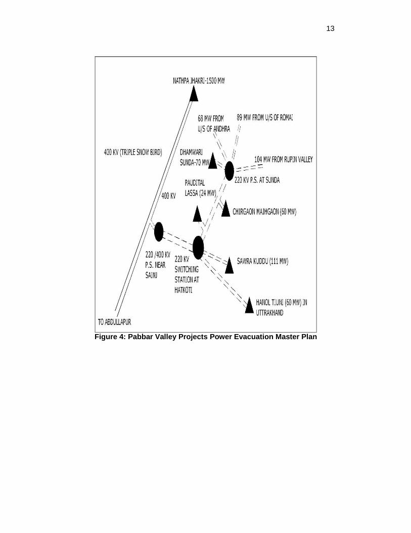
16. This project is being constructed to evacuate power from 111 MW Sawra Kuddu HEP (will be commissioned by year 2014) of Himachal Pradesh Power Corporation Limited (HPPCL). Other HEPs which will be commissioned in future like 44 MW Tangnu Romai HEP (commissioned by year 2016) of Independent power producers (IPPs) initially followed by other HEPs such as 60 MW Chirgaon Majhgaon (commissioned by year 2016), 24 MW Paudital Lassa (commissioned by year 2016), 70 MW Dhamwari Sunda (commissioned by year 2016) & 45 MW Rupin (commissioned by year 2017) and other small HEPs (will be commissioned in near future) being undertaken by various IPP’s and HP Government. As a number of new projects are upcoming in Pabbar River basin, HPPTCL is intending to construct an Integrated Transmission System in the area due to limited corridor availability and hilly terrain constraints. Total available potential in the area is about 524 MW. This 524 MW of power will be evacuated by constructing proposed 220 kV Hatkoti - Gumma (Pragati Nagar) line on twin moose conductor where it will terminate at the proposed 220/400 kV pooling substation Gumma (Pragati Nagar), which will link two circuits of 400 kV Jhakri- Abdullapur Line of PGCIL. This will take care of network reliability and redundancy in the system to evacuate power in case of outage of any transmission line because of unforeseen conditions. Figure 2 gives the location of the transmission line within the HP state. 2.2.2 400/220 kV GIS pooling sub-station Gumma (Pragati Nagar) 17. The substation is being constructed to pool power from 111 MW under construction Sawra Kuddu HEP (will be commissioned by year 2014) of Himachal Pradesh Power Corporation Limited (HPPCL). Other HEPs which will be commissioned in future include 44 MW Tangnu Romai HEP (commissioned by year 2016) of Independent power producers (IPPs) initially followed by other HEPs such as 60 MW Chirgaon Majhgaon (will be commissioned by year 2016), 24 MW Paudital Lassa (commissioned by year 2016), 70 MW Dhamwari Sunda (will be commissioned by year 2016) & 45 MW Rupin (commissioned by year 2017) and other small HEPs (will be commissioned in near future) being undertaken by various IPP’s and HP Government. As a number of new projects are coming in Pabbar River basin, HPPTCL is intending to construct an Integrated Transmission System in the area due to limited corridor availability and hilly terrain constraints. Total available potential in the area is about 524 MW.
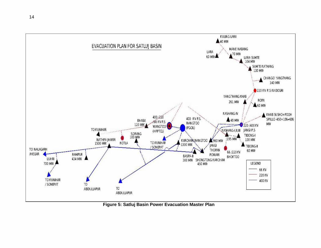
2.2.3 400/220/66 kV GIS Pooling station near Sherpa Colony (Wangtoo) 17. This project is being constructed to evacuate power from 65 MW under construction Kashang-I (will be commissioned by year 2013), 100 MW Tidong-I (will be commissioned by year 2014), 130 MW Kashang-II & III (will be commissioned by year 2014), 20 MW Raura-II (will be commissioned by year 2014), 24 MW Selti Masrang (will be commissioned by year 2014) and other 11 small power houses (commissioning in near future) having a total installed capacity of 81.6 MW through various IPP’s. The substation will cater about 421 MW power from various HEPs of Satluj basin.
2.2.4 220/66 kV GIS Pooling Station Bhoktoo 18. This project is being constructed to evacuate power from 3 MW Shyang (commissioned by year 2010), 5 MW Tangling (commissioned by year 2011), 5 MW Pangi (commissioned by year 2013) SHEPs of various IPP’s. Projects having an installed capacity of 8 MW have already been commissioned.
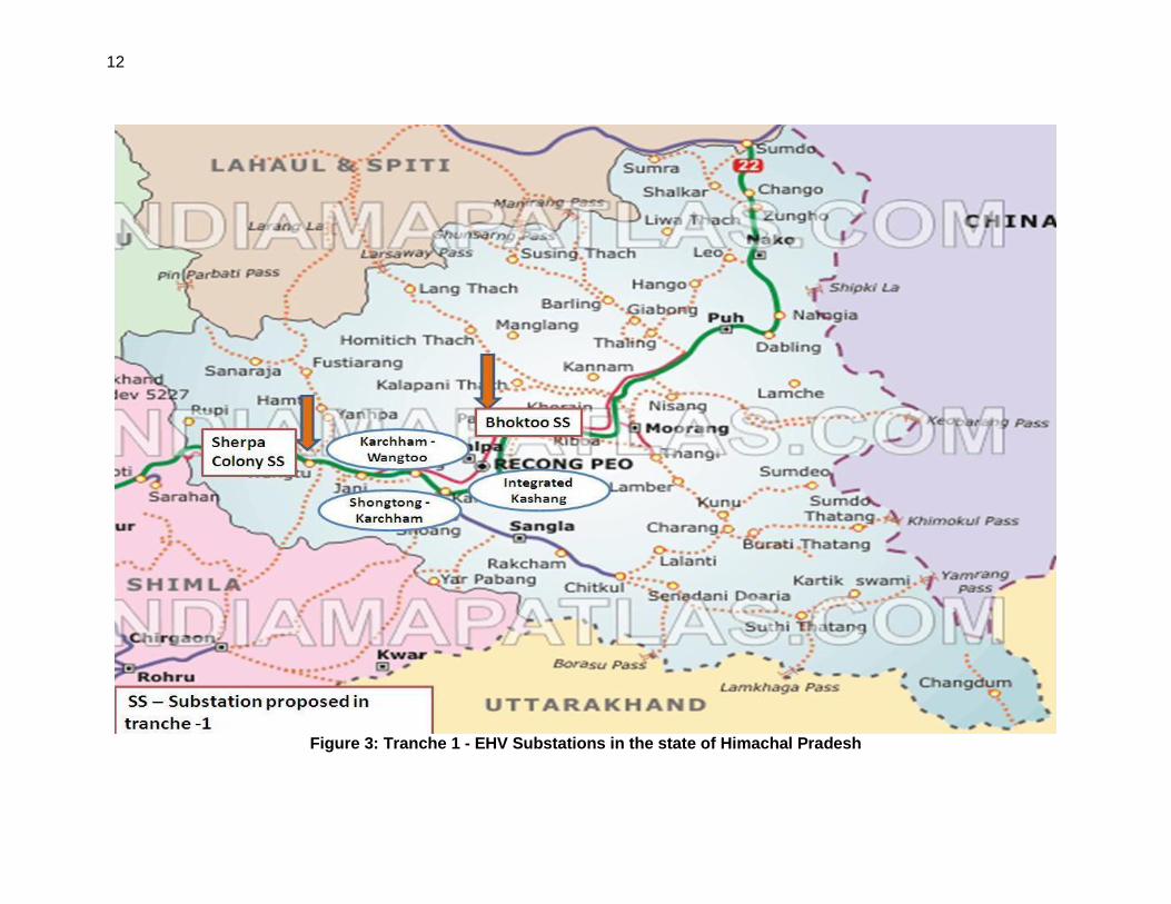
19. Figure 3 gives the location of the three EHV substations within the state.
5
2.3 Need for the Project 20. Due to the fast emerging energy demand in the country, there is a distinct necessity for strengthening and expanding the transmission networks. Himachal Pradesh is going to be the hub of clean energy generating facilities through hydroelectric potential. To evacuate overall power generated in Pabbar basin beyond Hotkoti and to save the limited available corridor a 220 kV twin moose conductor transmission line along with a 220/400 kV GIS pooling substation at Gumma (Pragati Nagar) which will be LILO with 400 kV Jhakri – Abdullapur line. This line and substation will evacuate 111 MW power from Sawra Kuddu HEP funded by ADB’s HP Clean Energy Development Investment Program (HPCEDIP) for HP Power Corporation Limited (HPPCL). 21. For catering overall generation capacity of Satluj basin, a 66/220/400KV pooling substation is proposed to be constructed at Sherpa Colony and it will be connected to proposed 400 kV substation of Power Grid nearby which will cater about 421 MW power from various HEPs of Satluj basin. Similarly to cater a overall generation capacity of 13 MW from small power stations adjacent to Bhoktoo, which needs to be evacuated, a 66/220 KV pooling station is proposed to be constructed and it will be connected to 220 kV Kashang- Bhaba line. The 220 kV Kashang- Bhaba line is further proposed to be LILO at 400/220 Pooling Station at Sherpa Colony (Wangtoo). Figures 4 and 5 show the two Masterplans for Pabbar and Satluj river basins for power evacuation schemes in the state of HP. 22. Consequent to the recommendations of the Master plan, under HPCETIP, Gas Insulated Switchgear (GIS) pooling substation are proposed in place of conventional Air Insulated Switchgear (AIS) substations to reduce cost of development of land and civil works which forms a major part of capital cost in hilly terrain. Power evacuation system has been designed so that each developer is provided with two distinct points for power evacuation. This arrangement provides reliability and any fault at one point can ensure continuity of power.
2.4 Location 23. The Tranche 1 projects are located in the Shimla and Kinnaur Districts of Himachal Pradesh. Himachal Pradesh extends from the Shivalik Hills in the south to the Great Himalayan ranges including a slice of trans-Himalayas in the north. The state falls between latitude 30’22‖ and 30’12‖ north and longitude 75’45‖ and 79’04‖ East. It is located between the Ravi river in the west and Yamuna river in the east. Its greatest length is 355 Km from the north-western extremity of Chamba to the South-eastern tip of Kinnaur and the maximum width is 270 Km from Kangra in Southwest to Kinnaur in the northeast. The altitude ranges from 450 to 6500 meters above mean sea level, which increases from West to East and South to North.
Table 2: General Profile of Shimla and Kinnaur Districts
S.N GENERAL INFORMATION Shimla Kinnaur
1. Geographical area (sq. km) 5131 6401 2. ii) Administrative Divisions (2001) i) Number of Tehsil & sub-tehsils 12 & 5 5 & 1 ii) Number of CD Blocks 9 3 iii) Number of Panchayats 337 65 iv) Number of Villages 2914 660 3. Population (2001 Census) 722502 78,334 i) Population Density (pers/sq. km) 141 12 ii) Rural & Urban Population (%) 77 & 23 100 & 0 iii) SC & ST Population (in percent) 26 & 0.60 9 & 71 iv) Sex Ratio (F:M) 896: 1000 857 4. Average Annual Rainfall (mm) 1180 816
220 kV double circuit transmission (twin moose conductor) line from Hatkoti to Gumma (Pragati Nagar) 24. Overview of the transmission line is provided in Table 1 below. Full details of the location of the towers resulting from the surveys undertaken by HPPTCL are presented in Annex 2 and a summary in Table 3 below.

6
Table 3: Transmission Line Details S No Detail Description
1 Line Length estimated 28 km 2 Total Tower locations 75 nos. 3 Total nos. of Railway Crossing 00 nos 4 Total nos. of road crossings 30 nos. 5 Total nos. of HT line crossings 21 nos 6 No. of forest trees to be cut 281 nos 7 No of fruit trees to be cut 484 nos 8 Distance from nearest Wildlife sanctuary/ National Park 60 m
400/220 kV GIS pooling sub-station Gumma (Pragati Nagar) 25. The work involves construction of new 400/220 kV substation at Gumma (Pragati Nagar) in the Shimla district of Himachal Pradesh. The substation is proposed to be constructed on private land identified and acquired by HPPTCL. Table 4 given salient features of the site.
Table 4: Details of Gumma substation site
SNo Feature Description
1 Area of land 25,007 sq. m / 2.5007 Ha 2 Geographical coordinates N - 31º 07’42.8‖ E - 77º 29’ 57‖ 3 Village / town Ghunda (Bagori) 4 Ownership of land Private 5 Name of owner Sh. N D Chauhan, Landlord 6 Slope/Plain Land Partially plain & sloping 7 Kind of Land Irrigated 8 River (if any) Baghi Khad (tributary) on east side 9 Permanent feature nearby if any Irrigation and Public Health Department (GoHP) percolation well and
Water Pump house toward Southern east side.
400/220/66 kV GIS Pooling station near Sherpa Colony (Wangtoo) 26. The work involves construction of a new 400/220/66 kV substation Wangtoo in the Kinnaur district of Himachal Pradesh. The substation is proposed to be constructed on vacant and barren government land identified in two separate sites due to limitations of land availability. These sites belong to the HP Government and will be transferred to HPPTCL. Salient features of the site are given in Table 5.
Table 5: Details of Sherpa Colony (Wangtoo) substation site
S No Feature Description
1 Area of land 49,400 sq. m / 4.94 Ha 2 Geographical coordinates N - 31º 32’57‖ E - 78º 01’ 03‖ 3 Village / town Sherpa Colony (Wangtoo), District Kinnaur 4 Ownership of land Government 5 Name of owner Katgaon Panchayat land (Government land) 6 Slope/Plain Land Steep sloping land 7 Kind of Land Grazing land 8 River (if any) Satluj River on southern ide 9 Permanent feature nearby if any JP – 400 kV Pooling substation Wangtoo
220/66 kV GIS Pooling Station Bhoktoo 27. The work involves construction of a new 220/66 kV substation at Bhoktoo in the Kinnaur district of Himachal Pradesh. The substation is proposed to be constructed on vacant and barren government land which is already acquired. Details are provided in Table 6.
Table 6: Details of Bhoktoo substation site SNo Feature Description
1 Area of land 15,200 sq m / 1.5 Ha 2 Geographical coordinates N - 31º 34’32‖ E - 78º 16’ 19‖ 3 Village / town Bhoktoo, District Kinnaur 4 Ownership of land Government 5 Name of owner HP. Government land 6 Slope/Plain Land Sloping land 7 Kind of Land Forest land 8 River (if any) No river nearby
7
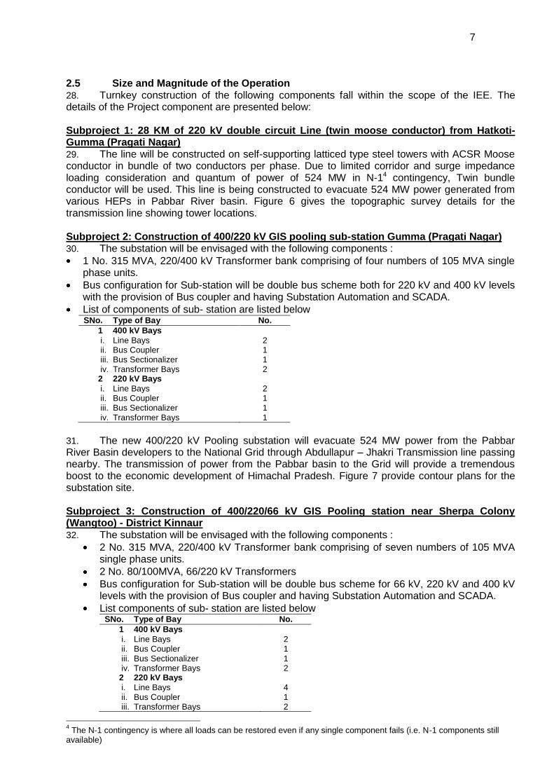
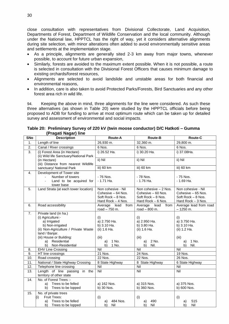
2.5 Size and Magnitude of the Operation 28. Turnkey construction of the following components fall within the scope of the IEE. The details of the Project component are presented below:
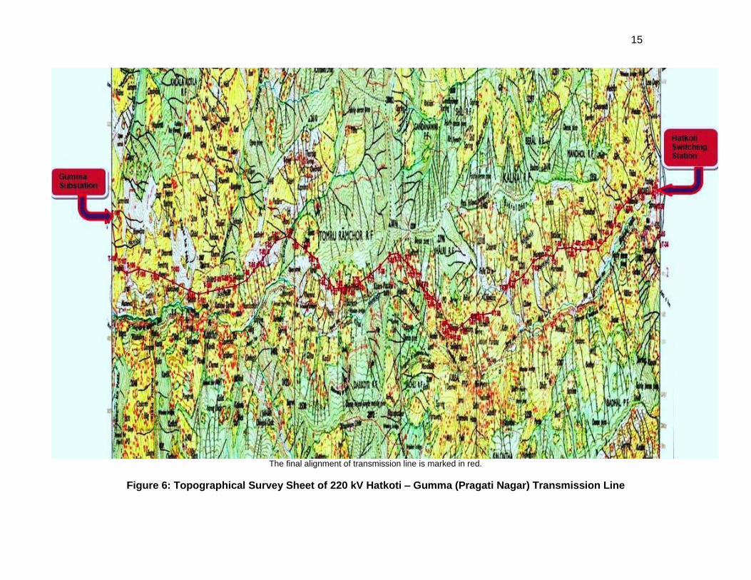
Subproject 1: 28 KM of 220 kV double circuit Line (twin moose conductor) from Hatkoti-Gumma (Pragati Nagar) 29. The line will be constructed on self-supporting latticed type steel towers with ACSR Moose conductor in bundle of two conductors per phase. Due to limited corridor and surge impedance loading consideration and quantum of power of 524 MW in N-14 contingency, Twin bundle conductor will be used. This line is being constructed to evacuate 524 MW power generated from various HEPs in Pabbar River basin. Figure 6 gives the topographic survey details for the transmission line showing tower locations.
Subproject 2: Construction of 400/220 kV GIS pooling sub-station Gumma (Pragati Nagar) 30. The substation will be envisaged with the following components :
1 No. 315 MVA, 220/400 kV Transformer bank comprising of four numbers of 105 MVA single phase units.
Bus configuration for Sub-station will be double bus scheme both for 220 kV and 400 kV levels with the provision of Bus coupler and having Substation Automation and SCADA.
List of components of sub- station are listed below SNo. Type of Bay No.
1 400 kV Bays
i. Line Bays 2 ii. Bus Coupler 1 iii. Bus Sectionalizer 1 iv. Transformer Bays 2
2 220 kV Bays
i. Line Bays 2 ii. Bus Coupler 1 iii. Bus Sectionalizer 1 iv. Transformer Bays 1
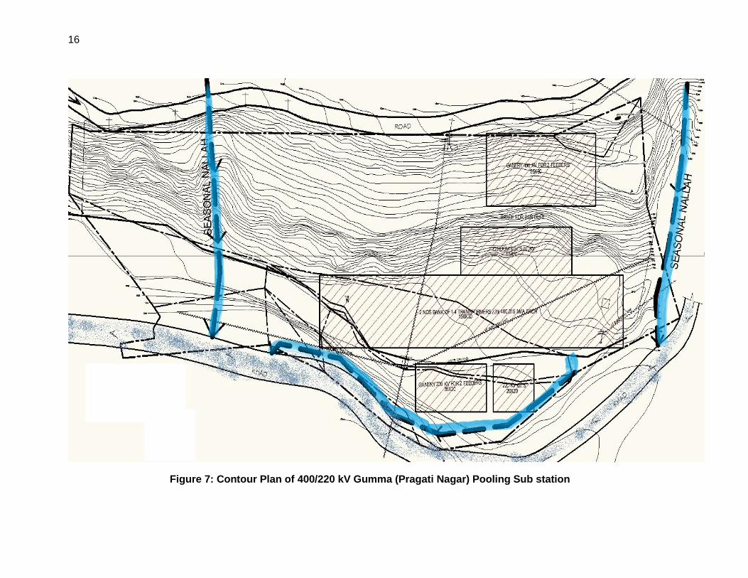
31. The new 400/220 kV Pooling substation will evacuate 524 MW power from the Pabbar River Basin developers to the National Grid through Abdullapur – Jhakri Transmission line passing nearby. The transmission of power from the Pabbar basin to the Grid will provide a tremendous boost to the economic development of Himachal Pradesh. Figure 7 provide contour plans for the substation site. Subproject 3: Construction of 400/220/66 kV GIS Pooling station near Sherpa Colony (Wangtoo) - District Kinnaur 32. The substation will be envisaged with the following components :
2 No. 315 MVA, 220/400 kV Transformer bank comprising of seven numbers of 105 MVA single phase units.
2 No. 80/100MVA, 66/220 kV Transformers
Bus configuration for Sub-station will be double bus scheme for 66 kV, 220 kV and 400 kV levels with the provision of Bus coupler and having Substation Automation and SCADA.
List components of sub- station are listed below SNo. Type of Bay No.
1 400 kV Bays
i. Line Bays 2 ii. Bus Coupler 1 iii. Bus Sectionalizer 1 iv. Transformer Bays 2
2 220 kV Bays
i. Line Bays 4 ii. Bus Coupler 1 iii. Transformer Bays 2
4 The N-1 contingency is where all loads can be restored even if any single component fails (i.e. N-1 components still
available)

8
3 66 kV Bays
i. Line Bays 4 ii. Bus Coupler 1 iii. Transformer Bays 2
33. The new 400/220/66 kV Pooling substation will evacuate 421 MW power from the Satluj River Basin developers to the proposed 400 kV substation of Power grid nearby which shall be LILO of 1 circuit of 400 kV Wangtoo – Abdullapur double circuit line of JP Power Grid. The transmission of power from the Satluj basin to the Grid will provide a tremendous boost to the economic development of Himachal Pradesh. Subproject 4: Construction of 220/66 kV GIS Pooling Station Bhoktoo - District Kinnaur 34. The substation will be envisaged with the following components :
1 No. 31.5 MVA, 66/220 kV Transformer (Justification provided above).
Bus configuration for substation will be double bus scheme for 66 kV, and 220 kV levels with the provision of Bus coupler and having latest Substation Automation and SCADA.
List components of sub-station are listed below SNo. Type of Bay No.
1 220 kV Bays
i. Line Bays 2 ii. Bus Coupler 1 iii. Transformer Bays 1
2 66 kV Bays
i. C&R Panels ii. Bus Coupler
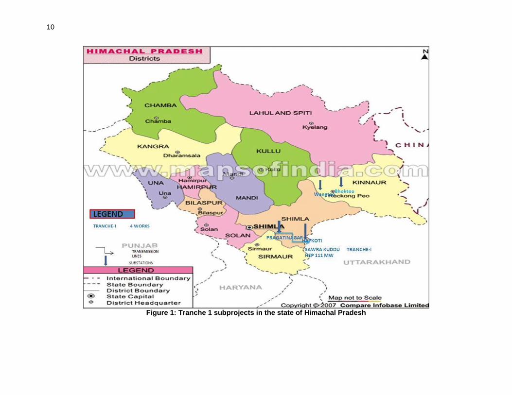
35. The new 220/66 kV Pooling substation will evacuate 13 MW power from the area of Satluj River Basin developers into the under construction 220 kV Kashang - Bhaba line by LILO of one of its circuit. The 220 kV Kashang-Bhaba line is further proposed to be LILO at 400/220 kV Pooling Station at Sherpa Colony. The substation shall also supply construction power to upstream projects including Shongtong – Karcham HEP of HPPCL. The transmission of power from the Satluj basin to the Grid will provide a tremendous boost to the economic development of Himachal Pradesh 2.6 Implementation Plan 36. The proposed Project involves construction of approximately 28 km of transmission line. The construction of substations involves government land in Wangtoo and Bhoktoo whereas Gumma (Pragati Nagar) substation will be built on a private agriculture land which will be acquired by HPPTCL. The project will involve survey work, land clearance, design and engineering of plant equipment, floating tenders for procurement, civil work and system testing and commissioning related to line and substation. Total project work costing is USD 142.30 million (including IDCs and contingencies). 37. The most optimal project route alignment is shown in the Figure 1. The overall project implementation schedule for the project is attached as Table 7.
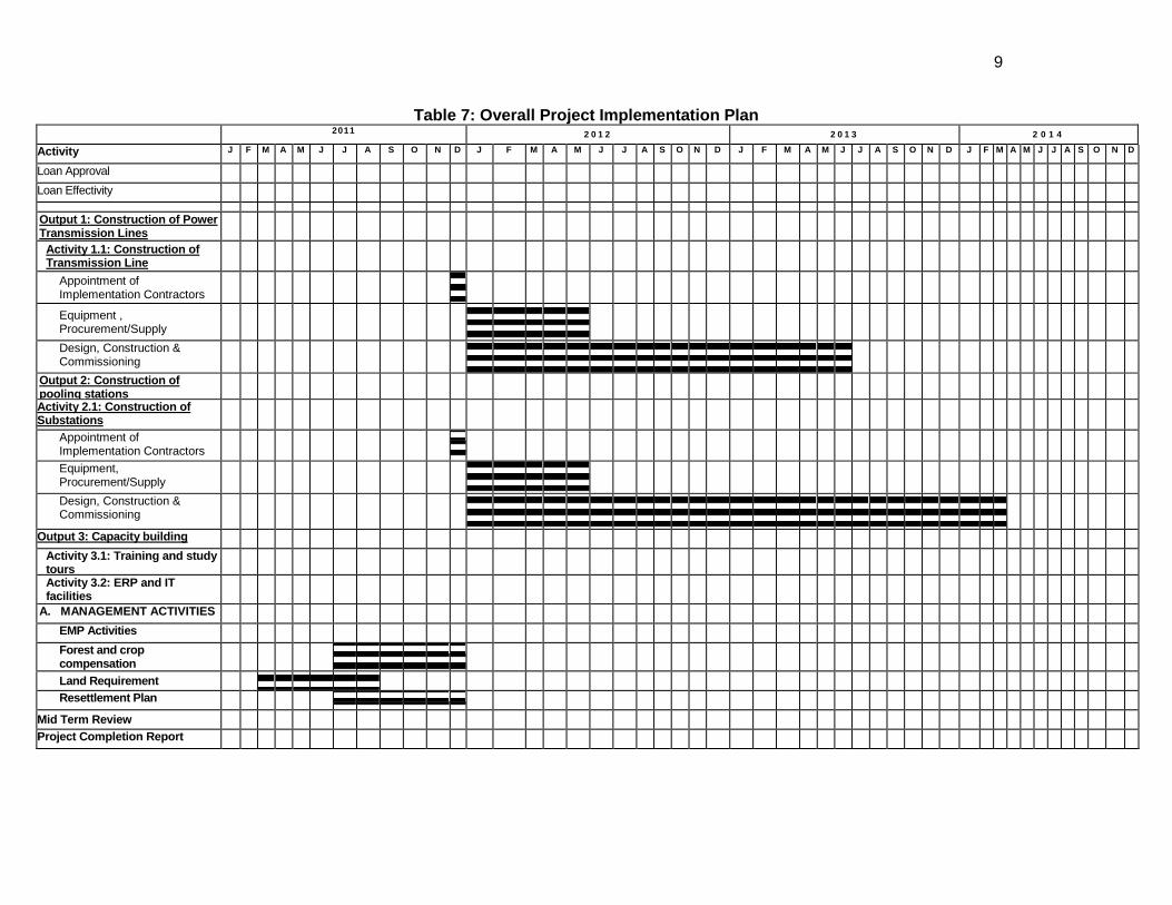
9
Table 7: Overall Project Implementation Plan 2011 2 0 1 2 2 0 1 3 2 0 1 4
Activity
J F M A M J J A S O N D J F M A M J J A S O N D J F M A M J J A S O N D J F M A M J J A S O N D
Loan Approval
Loan Effectivity
Output 1: Construction of Power Transmission Lines
Activity 1.1: Construction of Transmission Line
Appointment of Implementation Contractors
Equipment , Procurement/Supply
Design, Construction & Commissioning
Output 2: Construction of pooling stations
Activity 2.1: Construction of Substations
Appointment of Implementation Contractors
Equipment, Procurement/Supply
Design, Construction & Commissioning
Output 3: Capacity building
Activity 3.1: Training and study tours
Activity 3.2: ERP and IT facilities
A. MANAGEMENT ACTIVITIES
EMP Activities
Forest and crop compensation
Land Requirement
Resettlement Plan
Mid Term Review
Project Completion Report
10
Figure 1: Tranche 1 subprojects in the state of Himachal Pradesh
11
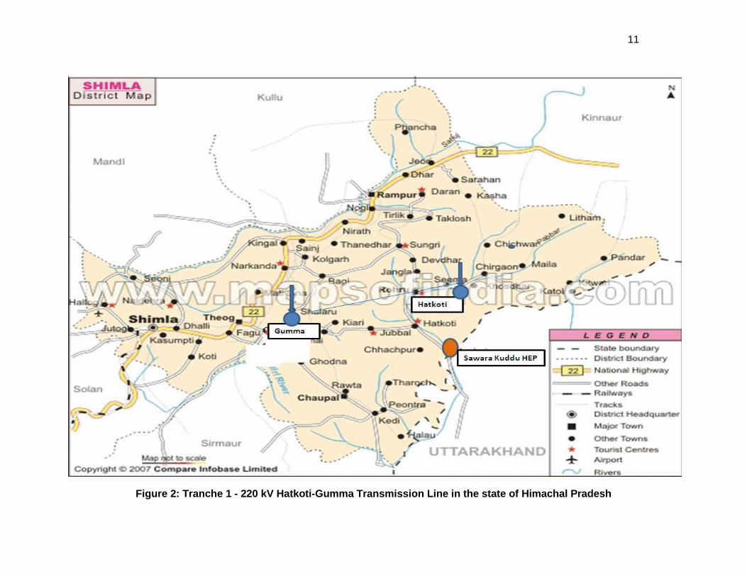
Figure 2: Tranche 1 - 220 kV Hatkoti-Gumma Transmission Line in the state of Himachal Pradesh
12
Figure 3: Tranche 1 - EHV Substations in the state of Himachal Pradesh
13
Figure 4: Pabbar Valley Projects Power Evacuation Master Plan
14
Figure 5: Satluj Basin Power Evacuation Master Plan
15
The final alignment of transmission line is marked in red.
Figure 6: Topographical Survey Sheet of 220 kV Hatkoti – Gumma (Pragati Nagar) Transmission Line
16
Figure 7: Contour Plan of 400/220 kV Gumma (Pragati Nagar) Pooling Sub station
17
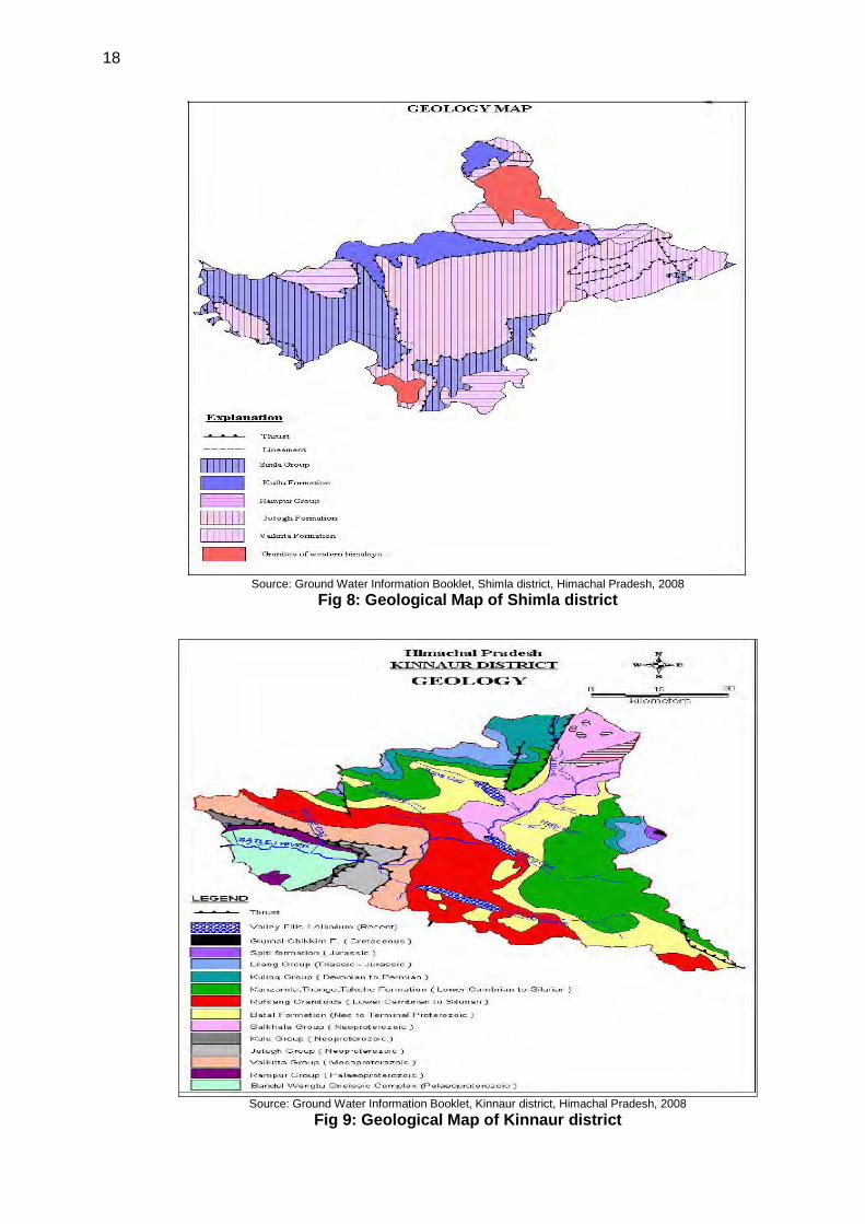
3.0 Description of Environment 3.1 Physical Resource 3.1.1 Topography, Geology and Soil Topography 38. Topographically, the State consists of five distinct sub-regions. These are (i) valley areas with elevations upto 1,000 metres, (ii) low hills, between 1,000 and 2,000 metres, (iii) high hills which lie between 2,000 and 3,500 metres, (iv) the alpine zone with altitudes above 3,500 metres, and (v) the land of the perpetual snows. Climatically, the zones identified are the Outer Himalayas, the Inner Himalayas and the Alpine. Except a few small valleys, the Shimla district is entirely mountainous. The elevation of the district ranges from 300 to 6,000 metres. The district has number of peaks, like Jakhoo in Shimla Town, Siah near Chail, Churadhar in tehsil Chopal, Chensal in Rohru tehsil, and Hatoo in Narkanda tehsil, and Shali in Seoni tehsil. Mostly the terrain is rough. The general topographical feature of the district is prevalence of interlocking spurs, narrow and steep sided valleys with high peaks and thick forest of Deodar and Kail. The soils are young and thin, however these get heavier and comparatively acidic with increase in altitude. Geology 39. Shimla district presents an intricate mosaic of high mountain ranges, hills and narrow deep valleys with altitude ranging from 1000 to 3000 m above MSL. In the areas underlain by high hill ranges of Himalayas, the valleys are narrow and deep with steep slopes trending in NW-SE direction. The terrain is moderately to highly dissected with steep slopes. The altitude is higher in north-eastern parts and decreases towards south and west.
40. Kinnaur district presents an intricate mosaic of mountain ranges, hills and deep valleys. It is primarily a hilly district with altitudes ranging from 1,500 to more than 6,500m above mean sea level. There is a general increase in elevation from west to east and from south to north. The major part of the district is drained by Satluj River except small part in the south-eastern area, which is drained by Ganga River. Geo-morphologically the district has been sub divided into the fluvial terrain, fluvio-glacial terrain, Alpines / meadows and Rocky terrain as shown in Table 8 for Shimla and Table 9 for Kinnaur districts below. Figures 8 and 9 depict the geological information in HP map.
Table 8: The generalized geological succession of Shimla district Age / Period Formation Lithology
Quaternary Alluvium Sand with pebble and clay, medium to coarse grained sand with pebble of sandstone and lenses of clay
Proterozoic Shimla group Siltstone, greywacke, sandstone, quartzite, conglomerate, Shale, slate, Phyllite, dolomite and meta-volcanic
Kulu group Schist, quartzite, banded gneiss, carbonaceous slate, limestone etc. Rampur group Phyllite, schist, quartzite, dolomite, and basic flows Vaikrita Group Biotite schist with kyanite, gneiss and migmatites Granite of Himalayas Granites
Source: Ground Water Information Booklet, Shimla district, Himachal Pradesh, 2008
Table 9: The generalized geological succession of Kinnaur district
Age / Period Group / formation Lithology
Quaternary Alluvium, Terrace & Fluvial deposits
Alluvium, clay, sand, gravel, pebble, boulder and cobble
Tertiary Nako Granitoid Granitoid Mesozoic Giumal – Chikkim Spiti formation,
Lilang Group Shale, Sandstone, Siltstone Carbonate rich sedimentary rocks
Palaeozoic Kuling Group Kunzamla, Thango, Takche formation
Sandstone, shale, conglomerate
Proterozoic Batal formation Salkhala, Kulu, Jutogh Vaikrita, Rampur Group, Bandal Wangtu Gneissic Complex
Slate, phyllite, quartzite and schist, Amphibolite, Gneisses, granite, Pegmatite
Source: Ground Water Information Booklet, Kinnaur district, Himachal Pradesh, 2008
18
Source: Ground Water Information Booklet, Shimla district, Himachal Pradesh, 2008
Fig 8: Geological Map of Shimla district
Source: Ground Water Information Booklet, Kinnaur district, Himachal Pradesh, 2008
Fig 9: Geological Map of Kinnaur district
19
Soil Regimes 41. The soils of the State can broadly be divided into nine groups on the basis of their development and physico-chemical properties. These are: (i) alluvial soils, (ii) brown hill soil, (iii) brown earth, (iv) brown forests soils, (v) grey wooded or podzolic soils, (vi) grey brown podzolic soils, (vii) planosolic soils, (viii) humus and iron podzols (ix) alpine humus mountain speletal soils. The soil found in the districts of Mandi, Kangra, Bilaspur, Una, Solan, Hamirpur and Sirmaur is generally brown, alluvial and grey brown podzolic, Kullu and Shimla have grey wooded podzolic soils, while Kinnaur, Lahaul and Spiti and some parts of Chamba district have humus mountain speletal soils. Mineral 42. As per investigation of Geological Survey of India, the minerals available in Himachal Pradesh include limestone, byrytes, clays, mica, iron pyrites, salt, gypsum, slate, antimony and lead. The distribution of these minerals is scattered all over the State and includes lime stone in Bilaspur, Sirmaur and Kangra districts; salt and slates in Mandi district; gypsum in Rajban, Bharli Sirmour district; Lahaul & Spiti and Sapatu in Solan district; byryte in Sirmour, iron ore in Mandi and Kangra; and uranium in Kullu and Hamirpur districts.
3.1.2 Climate and Meteorology Climate 43. There are four broad seasons. Winter normally starts from mid-November and continues till mid-March. December, January and February are severe cold months, when the winter season is at its peak. The upper reaches, have snow and sleet while the rains are frequent in the lower areas and snow may fall as early as the beginning of October but usually the areas have snow fall from the later part of December and continues till mid of March. The higher peaks experience heavier snowfall and it starts melting from March. From mid-March to mid-May, climate in most parts of the district is at its bloom because of the delightful spring. The nights are colder. The climate is comparatively hot from mid-May to mid-July. The places situated in the lower reaches on the banks of rivers and streams are as hot as plains. Rainy season generally starts from mid-July and extends up to the mid-September. Autumn season is generally very small from mid-September to mid-November. The extended rainy season and early setting of winter are the reasons for its short duration. Temperature 44. Due to variation in altitudes, the temperature varies considerably. Minimum temperature in the higher reaches often touches zero degrees centigrade during the winter months. The maximum temperature in the lower areas often exceeds 40 degrees centigrade during the summer months. Rainfall 45. Besides the seasonal variations, the climate of Himachal Pradesh varies at different altitudes. The average rainfall is 152 cms (60 inches). The highest rainfall occurs in Kangra district followed by Shimla district as shown in Table 10.
Table 10: Average yearly Rainfall Year Shimla Kinnaur Himachal Pradesh
2006 1,177.1 348.6 1,041.3 2007 967.4 310.9 1,000.5 2008 1,211.4 354.1 1,141.0 2009 825.6 269.4 907.9
3.1.3 Air Quality 46. As per Annual Report 2009–10 of Himachal Pradesh State Pollution Control Board (HPSPCB), Monthly mean average values of all the three air quality parameters, SO2, NOx, and RSPM were observed well below the permissible limit for 24 hour average in Shimla. Details are in Table 11.

20
Table 11: Air Quality Observed at Tekka Bench, Shimla SO2 in μg/ m
3 NOX in μg/ m
3 RSPM in μg/ m
3
Month Monthly Avg. Peak Monthly Avg. Peak Monthly Avg. Peak
April, 09 3.3 8.2 8.7 19.2 78 155 May, 09 2.8 10.4 7.5 15.5 79 165 June, 09 2.2 6.8 7.2 20.1 90 191 July, 09 2.1 6.3 5.3 16.0 49 116 August, 09 2.5 6.8 5.5 11.4 45 100 September, 09 2.5 5.8 6.4 13.3 39 115 October, 09 2.5 6.8 6.6 15.5 48 110 November, 09 2.7 7.8 8.5 16.9 51 133 December 09 2.7 7.1 8.8 24.9 83 386 January, 10 2.6 7.8 6.5 12.8 41 107 February, 10 2.3 5.8 8.5 16.5 50 101 March, 10 2.1 7.3 8.5 19.2 67 114
Source: Annual Report of HPSPB - 2009-10
3.1.4 Water Resources (Surface and Ground Water) Surface water 47. Richly endowed with perennial rivers that flow down steep gradients in mountain catchments, Himachal has a vast amount of water resources. These resources meet drinking water and irrigation requirements as well as supplying hydroelectric power to a large population. Drinking and irrigation requirements are also catered to by numerous springs, streams and infiltration galleries in limestone caverns. The use of ground water sources for irrigation is common in Una, Sirmaur, Solan and Kangra districts. Rivers and lakes 48. Himachal Pradesh has snow fed perennial rivers and rivulets flowing in almost all parts of the State. Yamuna, with its important tributaries of Tons, Pabbar and Giri in the east and Satluj, Beas, Ravi and Chenab in the west flow through various parts of the HP. Some of the important natural lakes worth mentioning are Khajjiar, Ghadasasu Lamba Dal, Manimahesh, Mahakali in Chamba district; Dal, Kareri in Kangra district; Rewalsar, Kumarwah, Prashar in Mandi district; Bhrigu and Dashahr in Kullu district; Chandratal and Surajtal in Lahaul & Spiti district; Chandra Naun in Shimla district; and Renuka in Sirmaur district. The manmade lakes include Gobind Sagar in Bilaspur district; Pong Lake in Kangra district; Pandoh lake in Mandi district; and Chamera lake in Chamba district. 49. Shimla district is drained by streams/rivers forming part of the drainage basins of the Satluj, the Yamuna, the Pabbar and Tons rivers. However, major part of the district is drained by tributaries of Satluj river viz., The Satluj river is the longest river traversing along the northern boundary of the area and Giri river which is the tributary of the Yamuna river originate from the eastern part and runs in the SW direction. Whereas tributaries of Tons river flows in the southern parts and the Pabbar river in the eastern parts of the district. In general, the density of drainage is moderate to high and is not uniform all over the district. 50. In district Kinnaur, the ground water is distributed along structurally weak/ fractured zones, faults and landslides zones or along the contacts of the different rock formation in the topographically favorable areas. In the Satluj River valley, the areas around Taranda, Tapri, between Oling and Lipa, Moorang and Tabling are most promising for water exploration. The other ground water potential areas are along Baspa River, Tidong Gad, Taiti Gad and Spiti River. The traditional dug wells tapping the shallow aquifer are not available however; this aquifer is being tapped by the hand pumps and shallow tube wells, which are widely used for domestic purposes. The deep tube wells have not been constructed by Central Ground Water Board (CGWB). Ground water in the district occurs in valley area under water table and semi confined to confined conditions. The average depth to water level in shallow bore well ranges from 10 to 30 m below ground level. Ground Water Quality 51. As per Ground Water Information Booklet, Shimla district, Himachal Pradesh, 2008 the chemical quality of ground water is generally alkaline in nature and suitable for both domestic and
21
irrigation use all over the district. All the parameters of ground water were found well within the permissible limit of safe drinking water as per Bureau of Indian Standard (BIS). 52. As per Ground Water Information Booklet, Kinnaur district, Himachal Pradesh, 2008, the ground water of the district is alkaline in nature. pH of shallow ground water ranges from 6.95 to 7.75. The electrical conductivity (EC) in the area ranges from 127-672 micro mhos/cm. Nitrate values range between 1-10 mg/l. The chemical quality revels that the overall ground water quality is good and is suitable for domestic and irrigational use. However, quality of water from hot springs in Karcham has brackish water with EC 1780 micro mhos/cm and fluoride concentration 3.5 mg/l. 53. In both districts, due to poor potentialities in hilly hard rock areas and sloping hilly terrain, groundwater development is low. However, in these areas, major water supply and sources of water are ground water based viz., perennial springs, bowries and hand pumps. Springs are tapped at the source so that the water can be supplied under gravity. All major towns and villages are supplied water from ground water sources. 3.2 Earthquake Zone: 54. The state of Himachal Pradesh lies almost entirely in the Himalayan Mountains, and is part of the Punjab Himalayas. Due to its location it weathers many mild earthquakes every year. Large earthquakes have occurred in all parts of Himachal Pradesh, the biggest being the Kangra Earthquake of 1905. The Himalayan Frontal Thrust, the Main boundary Thrust, the Krol, the Giri, Jutogh and Nahan thrusts lie in this region. Besides that there are scores of smaller faults, like the Kaurik Fault which triggered the 1975 earthquake. Chamba, Kullu, Kangra, Una, Hamirpur, Mandi, and Bilaspur Districts lie in Zone V. The remaining districts of Lahual and Spiti, Kinnaur, Shimla, Solan and Sirmaur lie in Zone IV therefore the HPPTCL need to take adequate measures while designing to avoid damage during earthquake. Figure 10 depicts the earthquake hazard risk zonation of the entire Himachal Pradesh State.
55. The transmission towers and the substation sites falls in Seismic Zone IV area (High Damage Risk Zone – MSK VIII) which indicates a very high damage risk zone. Therefore, HPPTCL is required to take adequate measures while erecting transmission lines to ensure least damage during earthquake. The proposed route alignment passes through Zone IV. Similarly, the proposed substations also fall in Seismic Zone – IV and therefore the HPPTCL needs to take adequate measures while designing and installation of components of subprojects to avoid damage during earthquake.
Source: Amateur Seismic Centre, Pune, 2011
Figure 10: Earthquake Zone of Himachal Pradesh
22
3.3 Ecological Resources 3.3.1 Terrestrial Ecology Forest 56. Forests are an important resource of Himachal Pradesh. Although the area classified as "Area under Forest" is 67 percent of the total area of the Pradesh, yet the effective forest cover is much lower than this area, primarily on account of the fact that a very large area is either alpine meadows or is above the tree line.
57. The climatic conditions prevailing in Himachal Pradesh and varying elevations are most suitable for the growth of forests. The forests provide valuable timber, medicinal herbs, raw material for industries and also provide employment and play a vital role in conserving the soil and ensure timely rains. As shown in Table 12, in district Shimla, 340,103 hectares of land area was under forest at the end of the year 1989-90. However, by the year 2008-09, the land area under forests rose to 336,683.25 hectares. Out of this total area under forests, in the year 2008-09, 127,722.21 hectares constituted reserved forests, 5,337.42 hectares as protected forests and 203,623.62 hectares as un-demarcated forests.
Table 12: Status of Forest Cover Forest Cover 2007
S No Item Area (in km2 )
Shimla Kinnaur Himachal Pradesh
1 Geographical Area 5,131 6,401 55,673 2 Very Dense forest 739 82 3,224 3 Moderate Dense forest 1,037 263 6,383 4 Open forest 608 257 5,061
Sub-total 2,384 602 14,668
Scrub Forest 32 70 327 Source: India State of Forest Report 2009
Legal Status of Forest Area (2008-09) Area In Hectares
Shimla Kinnaur
1 Reserve Forest 127,722.21 43,180.00 2 Protected Forest 5,337.42 3 Unclassified forest 203,623.62 503,788.63 4 Total forest In Circle 336,683.25 546,969.52
Source : District Statistical Abstract, 2008 - 09
58. In Shimla district, important species of trees such as Deodar, Kail, Chil, Oak, Mohru and Kharll etc. are found in the forests and the major forest produce are resin and medicinal herbs. The available resin in the district is being processed by two resin and turpentine factories at Bilaspur and Nahan. However the medicinal herbs are being exported in raw form out of the district. The forests in the district lie mainly in the outer Shivalik to the mid Himalayas. The soil is generally sandy loom and depth is shallow, except in the areas having vegetation over where it is fairly deep. In the regions above 1,500 metres, the soil is generally deep and contains a thin layer of leaf molded species of Ban, Oak, Chil, Kail and Deodar. In the lower elevation, shrub forms are found while in the higher altitude Chil, Deodar, Kail etc. are available. In the lower ranges with warmers aspects and sharp slopes, with deep soil and favourable condition, species of mixed forest, of bamboo and shrubs are found.
59. The area of forests in the Kinnaur according to the forest department is 386 km2 (averaging 6.03 per cent of the total geographical area viz., 6,401 km2). Traditionally, Nichar and Kalpa sub-division were known for stately cedar and kail trees. Beyond Karchham, large wild forest of Chilgoza trees abound and their edible nuts fetch handsome income. On the basis of rainfall, the district can be divided in two zones; wet zone and dry zone. Wet zone gets the rainfall due to monsoon while the dry zone does not get any rainfall. Pinus roxburghii, Pinus wallichiana, Cedrus deodara, Picea smithiana and Abies pindrow, Pinus gerardiana form a broad belt of forest along both sides of the Sutlej valley and the side streams between the cliffs of the gorge below and alpine pasture and eternal snows above. The three main division of forest cover are: (a) Moist Zone Forest (The Tranda range forests), (b) The Dry Zone Forests (Chini and Kilba Kailash ranges), and (c) Arid Zone Forests (the parts adjoining Tibetan border).

23
Flora 60. The Shimla district is endowed with a variety of trees, shrubs grasses and climbers. In addition to the above mentioned varieties of trees found in district Shimla, certain other varieties of trees available are Tosh, Khair, Rikhaudlu, Parong, Bul, Khanor Siris, Kunish, Chal Dahu, Neem, Karyal, Badhar, Dhak, Amaltas, Diar, Shisham, Chilru, Samana, Safeda, Barmeli Shin, Chuli, Rai Jharinu, Kaphal, Amb, Kela, Ailan, Akhrot, Beul, Ban, Kainth etc. Certain shrubs, found in the district are, Ramban, Bassuti, Akhota, Charmar, Kashamal, Bomol, Sandroi, Ailwan, Ak, Bhang, Karunda, Relan, Kringham, Pror, Gadoos, Gangara, Reuns, Chamror, Kothla, Murt, Mehndu, Sidhara, Kathi etc. 61. Portions of Kinnaur are situated high in the Himalaya, where vegetation is sparse and consists primarily of hardy grasses. Alpine species such as juniper, pine, fir, cypress, and rhododendron can be found at elevations between 3,500 and 5,000 meters, primarily in Middle Kinnaur. At lower altitudes, temperate-climate trees are found, including oak, chestnut, maple, birch, alder, magnolia, apple, and apricot. Fauna 62. The Shimla district used to be a home of wild life in the distant past. Certain important animals found in the district are Suar, Hiran, Khargosh, Bagh, Bhalu, Ghurral, Kakar, Chittal, Sambar etc. Certain birds found are, Bater, Ghuggi Mor, Kala Tittar, Harrial, Kabuttar, Jangle Murgi, Kolsa, Chakour etc. In Kinnaur district, Serow, Blue Sheep, Red Fox, Musk Deer, Goral, Ibex, Leopard, Snow Leopard, Brown Bear, Himalayan Black Bear are found different wild life sanctuaries of the district, Yaks, Dzos and Ponies are reared by local farmers in the higher areas. Rupi-Bhaba Sanctuary 63. Rupi Bhaba sanctuary is located in the District Kinnaur at the altitude of 909 to 5,650 meter. The temperature varying from -10° to -20° C, rainfall 45 mm and snowfall is 300 mm. This sanctuary was first notified on 28th March 1982 and renotified on 30th June 1982. The wide variation of altitude supports a large diversity of habitats and wild life. This sanctuary lies on the left bank of the Satluj river. The Great Himalayan and Pin Valley National Parks are located on its western and northern boundaries respectively. The species found in this sanctuary are Serow, Blue Sheep, Red Fox, Musk Deer, Goral, Ibex, Leopard, Snow Leopard, Brown Bear, Himalayan Black Bear etc. The forest types include lower western Himalayan temperate, Kharsu Oak, Alpine pastures, dry temperate coniferous and dry broad leaved coniferous. 64. This sanctuary is separated by atleast 10 km aerial distance from the Kinnaur district projects and is about 60 km away by an aerial distance from Shimla district projects. 3.4 Economic Development Industries 65. On account of difficult geographical terrain and topography of the district, the chances to set up modern, medium and large scale industries are quite limited in the district. Therefore, there are only cottage and small scale industries that rely on varied type of local raw materials, like wool, juices, fruits and wood. The cool and dust free climate of the district is also quite congenial for the growth of electronic industry in the district. There is one electronic complex operating in Shoghi. Cotton carding, thresher, fruit canning preservation, bakery, oil expeller etc. are the main agro-based industries operating in the district. Earlier, wooden packaging cases, was the main wood based industry, operating in the district, but with the replacement of wooden boxes by cartons, this industry has lost its importance. However, wooden furniture, toys, sticks, joinery are still operating in the district. Stone crusher and earthern pottery are the main mineral based industries of the district. There are number of textile based units also which are engaged in the manufacturing of hosiery products, shawls, chaddars, fancy handicraft etc. Further, there are some engineering, chemical and electronic based units also operating in the district. Some of the engineering units, are producing barbed wire, wire nails, tin smithy products, steel fabrications, steel furniture, auto repairs and sewing machine, assembling etc. Laundry soap, detergent, bread wrapper, ink, candle making, tyre retreading are some of the chemical based units set up in the
24
district. Electronic based products being produced in the district, are video cassettes, televisions, voltage stablizers TV/radio repairs and intercom etc.
3.4.1 Employment
66. According to the Census, 2001, Himachal has 19,63,882 main workers and 10,28,579 marginal workers in the State as per 2001 census. There are around 64.1% of the total working population of Shimla and 68.8% of Kinnaur’s working population is engaged as cultivators, 2.7% and 2.3% working population of Shimla and Kinnaur district are engaged in agriculture labours works 1.2% and 1.8% are working in household industries and 32% and 31.1% are other workers. This means that there is one main worker for every 3.09 persons and one marginal worker for 5.91 persons. Combining the number of main and marginal workers, it works out that there is one worker for every 2.03 persons. The Table 13 below shows that majority of the population is worker.
Table 13: Population wise male and female workers in Shimla and Kinnaur district Area Population Total Workers
(Main + Marginal) Non-Workers
Persons Males Females Persons Males Females Persons Males Females Shimla 722,502 380,996 341,506 370,223 21,9133 151,090 352,279 161,863 190,416 Kinnaur 7,8334 42,173 36,161 47,811 28,041 19,770 30,523 14,132 16,391
Source Primary Census Abstract: 2001
Infrastructure Rural Roads and Communication System 67. Total motorable road in the district is 4,171 kms out of which 4,010 is motorable. 2,048 kms is metalled and 1,172 kms kutcha. In absolute terms, road length works out to be 78.15 kms per 100 sq. kms against the state average of 46.64. Distance from a health institution, travel time, means of transport have an effect on the utilization of services in health facilities and also affect the timely referral of emergencies. Telephone density is 74.5 per 2000 population but telecommunication revolution in the state has increased the communication to a great extent. It has helped in quick response to disasters and emergencies. Rapid communication prevented any loss of life during flash floods in Satluj river caused by breach of Parechu lake in Tibet in 2005.
Water Supply 68. As per planning department of Himachal Pradesh, all 16,997 villages in the State as per census 1991 were provided with safe drinking water facility by March, 1994. As per the survey of 2003, which was finalized in March, 2005, 51,848 habitations were identified. Of these, 20,112 were categorized as fully covered (FC) and 31,736 habitations as non-covered and partially covered (9389 NC and 22347 PC). These 31,736 habitations have been categorized as slipped back habitations as per revised guidelines of the Central Government. 69. Availability of piped and potable water supply affects the health of people. As on December 2006, number of partially covered villages was 479 and number of fully covered villages was 6,031. None of the villages in the district remains uncovered. In addition, 938 hand pumps were functional in the district. By and large piped water supply is ensured but quality of water is still a question mark. Water borne diseases constitute single largest group of all diseases.
Electrification 70. As per the district statistical abstract, 100% rural electrification has been achieved in the Shimla district and 85.47% achieved in Kinnaur district by 31st March 2010.
3.4.2 Education 71. According to 2001 census, the overall literacy percentage of Himachal Pradesh was 76.5% (85.30% for males and 67.40% for females). Comparatively, it is much higher than the all-India literacy rate, which is 65.38%. The literacy rate in Himachal Pradesh has been improving faster than the all-India figures. Himachal Pradesh is characterised by a very strong correlation
25
between sex ratio (females per thousand and males) and literacy. Districts with higher density of female population vis-à-vis male population have high literacy rates.
72. There are 1,612 primary school and 350 secondary and 306 higher secondary schools. The district has some technical and law colleges and a provision of distance learning programs and correspondence courses offered by various study centres under Open University Scheme of Indian universities (details in Table 14).
Table 14: Detail of School and Colleges in year 2009 - 10 S No. Item Nos.
Shimla Kinnaur
1 Primary schools 1612 189 2 students enrolled in Primary Schools 52663 5,904
3 Teachers in Primary schools 3545 532
4 Secondary schools 350 38 5 students enrolled in Secondary Schools 35266 3,811 6 Teachers in Secondary schools 3462 119 7 Higher Secondary Schools 306 44 8 Students enrolled in Higher Secondary 53709 3,857 9 Teachers in Higher Secondary Schools 4926 439 10 Colleges 09 1 11 Students enrolled in Colleges 12858 321 12 Colleges Teachers 270 21
Source: District Statistical Abstract 2009-10
3.4.3 Health Environment 73. Shimla district has 1645 allopathic hospitals, 220 community health centres, 201 primary health centres, and 28 civil hospitals. Table 15 given the details.
Table 15: list of Government Institutions SNo Health Institution Shimla Kinnaur
1 Regional Hospitals 1 1 2 Civil Hospital 28 1 3 Community Health Centres 220 3 4 Primary Health Centres 201 21 5 Sub-Centres 112 31 6 Ayurvedic Hospitals 2 1 7 Ayurvedic Dispensaries 147 27
Source : Districts official website
74. As per the reports of Planning department of Himachal Pradesh Table 16 shows the status of various infrastructure in the State as on 31st March 2009.
Table 16: Rural Infrastructure in Himachal Pradesh at the end of 31st March 2009
No. Item Unit Position as on 31.3.2009
1 Road Length (Motorable) Kms. 30,302 2. Villages connected with Roads No 9,243 3 Bridges No 1,604 4 Primary Schools No 10,751 5. Middle Schools No. 2,338 6 High Schools No. 835
7 Senior Secondary Schools No. 223 8 Veterinary Hospitals No. 283 9. Veterinary Dispensaries No. 1,753 10. PHC/CHC/RH/SHCs No. 522 11. Health Sub-Centres No. 2,071 12. Civil Dispensaries No. 41 13 Ayurvedic Dispensaries No. 1,126
Source: Planning department, Himachal Pradesh (http://hpplanning.nic.in/)
3.4.4 Land Use 75. The Shimla district is spread over deep small valleys and high elevations and cultivation is possible only in small terraces of holdings in the high hills or in the basins of streams/khads.

26
However, in the deep valleys though very few in number, the cultivation is spread over in a vast area. Most of the land, is either under shrub forests or greasy land with Chil, Pine trees up to the height of 1,500 metres from mean sea level and Kail, Deodar, Rai, Ban, Mauru, Rhododendrons and Kanor on the high altitude. Near the basins of rivers and khads, land is flat and fertile and the cultivation of cereals and pulses and seasonal vegetables is done extensively. Sloping areas of high altitudes are most suitable for horticulture purposes for apples, almonds, walnuts, apricots etc. 76. Prior to the coming of Tenancy and Land Reforms Act, there were three kinds of land tenure systems prevalent in the district and these were (i) Zamindari, (ii) Pattedari and (iii) Bhaichara. Zamindari system of land tenure was abolished after the introduction of Himachal Pradesh Tenancy and Land Reforms Act and most of the cultivators who were tenants of the landlords for generations became the owners of the land except in case of holdings of those land lords who were minors, widows, disabled and service personnel. Land holding in the hilly terrains, of the district are small in size, scattered and fragmented and comprise terraced fields, in major part of the cultivable area. With a view to do away, with uneconomical land holdings, the Government of Himachal Pradesh has taken certain steps for the consolidation of holdings, under the Consolidation of Holding Act. Table 17 shows the Land Use pattern in HP state.
Table 17: Land use pattern of Himachal Pradesh
SNo Land Use Area in Ha Percentage
1 Total geographical area 5,567 2 Reporting area for land utilization 4,545 100.00 3 Forest 1,101 24.22 4 Not available for cultivation 1,130 24.86 5 Permanent pasture and other grazing lands 1,501 33.03 6 Land under misc. Tree crop & groves 69 1.52 7 Culturable wasteland 127 2.79 8 Fallow lands other than current fallows 14 0.31 9 Current fallow 60 1.32
10 Net area sown 543 11.95
Source: India State of Forest Report 2009
77. Total land requirement for Tranche 1 subprojects is given in Table 18 below:
Table 18: Total land required for tranche 1 subprojects
SNo Project Total Land Area Private Land Govt./Forest land
1 220 kV Hatkoti – Gumma Line 95.9538 ha 69.4264 ha 26.5274** ha 2 220/400 kV GIS Pooling station Substation,
Gumma 2.5007 ha 2.5007* ha Nil
3 400/220/66 kV GIS Pooling station, near Sherpa Colony, Wantoo
7.9108 ha Nil 7.9108 ha
4 220/66 kV GIS Pooling Station, Bhoktoo 1.2639 ha Nil 1.2639 ha
* Section 4 for land acquisition is issued by HPPTCL ** Forest Clearance case has been prepared under process with the HP forest department
Agricultural: 78. According to Agriculture production, the Shimla district can be divided into three broad regions: (i) Valleys and basin areas (ii) mid hills and (iii) high hills. The low lying areas of Rampur, Seoni, Kumarsain, Jubbal and Kotkhai, Chopal, Mashobra, Theog and Rohru tehsils, are particularly suitable for the cultivation of cereal crops. In the mid hill areas of these areas/blocks, the scope to produce vegetables, fruits and cereals is immense. The higher elevations of these blocks are suitable, for growing apples, cherry, seed potatoes, almonds and walnuts, paddy, wheat, maize, millets and pulses. Mushroom cultivation and a number of vegetables such as potatoes, peas, cauliflower are also grown in the district. Central Potato Research Institute which has a Potato research station in Kufri and Potato farms are functioning in Shillaru, Kharapathar, Khadrala and Dhurlain.
79. The economy of Kinnaur is predominantly agriculture based where as large as 67.09% of the total working force is engaged in tilling the cultivable land. The space of arable land is small and the cultivation is common on narrow strips along the browse of the mountains. The crops for
27
the most part are poor and a great scarcity of grain pervades. In time of scarcity, horse chestnuts are dried and ground into flour; apricot and walnut. The standard grains of Kinnaur are Barley, Phaphra (Fagopyrum esculentum) and Ogla (Fagopyrum emerginatum); Barely is sown in March-April and harvested in July after which the fields are prepared for the Ogla and Phaphra which are harvested in October. At the places of one cropping season, the important crops grown are Ooa (Hordeum coeleste), wheat, Phaphra and Barley which are sown in April and harvested in August-September. The other grains are Bathu (Amranthus), Cheena (Panicum miliaceum) and Koda (Paspalum ocribiculatum). Generally, the local millets are grown as cereals. A long and typical winter season is responsible for low production. Non-food crops do not have much of importance. Farming by and large is dependent on irrigation and the main sources are the Kuhls (water channels) drawn from the streams fed by glaciers. Due to high profits, the people have enthusiastically taken to raising off-season vegetable crops like cabbage, peas, tomatoes, beans, seed potato and pulses.
Table 19: Crop calendar
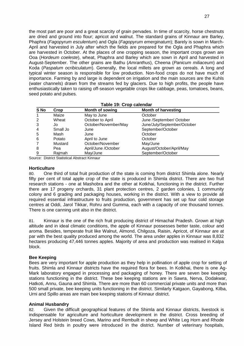
S No Crop Month of sowing Month of harvesting
1 Maize May to June October 2 Wheat October to April June /September/ October 3 Jo October/November/May June/July/September/October 4 Small Jo June September/October 5 Mash June October 6 Potato April to June October 7 Mustard October/November May/June 8 Pea April/June /October August/October/April/May 9 Rajmah May/June September/October
Source: District Statistical Abstract Kinnaur
Horticulture 80. One third of total fruit production of the state is coming from district Shimla alone. Nearly fifty per cent of total apple crop of the state is produced in Shimla district. There are two fruit research stations - one at Mashobra and the other at Kotkhai, functioning in the district. Further there are 17 progeny orchards, 31 plant protection centres, 2 garden colonies, 1 community colony and 6 grading and packaging houses, working in the district. With a view to provide all required essential infrastructure to fruits production, government has set up four cold storage centres at Oddi, Jarol Tikkar, Rohru and Gumma, each with a capacity of one thousand tonnes. There is one canning unit also in the district.
81. Kinnaur is the one of the rich fruit producing district of Himachal Pradesh. Grown at high altitude and in ideal climatic conditions, the apple of Kinnaur possesses better taste, colour and aroma. Besides, temperate fruit like Walnut, Almond, Chilgoza, Raisin, Apricot, of Kinnaur are at par with the best quality produced among the world. The area under apples in Kinnaur was 8,832 hectares producing 47,446 tonnes apples. Majority of area and production was realised in Kalpa block.
Bee Keeping Bees are very important for apple production as they help in pollination of apple crop for setting of fruits. Shimla and Kinnaur districts have the required flora for bees. In Kotkhai, there is one Ag-Mark laboratory engaged in processing and packaging of honey. There are seven bee keeping stations functioning in the district. These bee keeping stations are in Sawra, Nerva, Dodakwar, Hatkoti, Annu, Gauna and Shimla. There are more than 60 commercial private units and more than 500 small private, bee keeping units functioning in the district. Similarly Katgaon, Gayabong, Kilba, Urni and Spillo areas are main bee keeping stations of Kinnaur district. Animal Husbandry 82. Given the difficult geographical features of the Shimla and Kinnaur districts, livestock is indispensable for agriculture and horticulture development in the district. Cross breeding of Jersey and Holstein breed Cows, Marino and Rembuilt in sheep and White Leg Horn and Rhode Island Red birds in poultry were introduced in the district. Number of veterinary hospitals,

28
dispensaries, outlying dispensaries artificial insemination centres is also functioning in the district to prevent common ailments and control of infectious diseases. For improving, the quality of sheep and wool, Government Sheep Breeding farm at Jeori is supplying improved sheep to the breeders of the district.
Fishery 83. Fishing in the state is regulated under Himachal Pradesh Fisheries Act, 1976. Satluj and tributaries of Yamuna - Giri, Pabber Tons, Ashani and Shalvi have more than 400 km length available for fishing. Some of the fish species are Turputitora, Salmotrulta, Schyzpthorax, Fasio Salmo, Gairdineri, Gairedinerri Bagarius and weedy fishes. Fast flowing, cold water, in different rivers and khuds is quite suitable for tropical species of fish in the district. Tourism 84. Shimla and Kinnaur districts being tourist hubs, have many places of historical, archaeological and religious importance. Apart from Shimla town, Kufri, Naldehra, Narkanda, Rohru, Hatkoti, Kotgarh, Rampur, Sarahan are the main centres, of tourist interest. Kalpa, Reckong Peo, Sangla, Chango, Chhitkul, Kothi, Leo, Lippa, Moorang, Nichar are tourism centres in Kinnaur district. Shimla, is also known for a number of fairs and festivals. Lavi fair of Rampur, which has acquired the status of international fair, is the most important and popular fair of the district. Large number of traders come all the way from other states to Rampur to buy woollen articles, dry fruits and medicinal herbs. Certain other fairs held in the district are Sippi fair of Mashobra, Barara fair of Kumarsain, Bhoj fair organized in village Guman in Rohru Tehsil, Charyoli fair held in village Bodna in Chopal tehsil, Chunehar fair of Theog tehsil, Dudhbahali fair of Rampur tehsil. In addition, Jagna Shari fair of tehsil Jubbal, Mahasu Jatar (Mahasu Village), Pathar-ka-khel fair (of Halog), Rampur-k-Jatar (village Rampuri), Rihali Fair (Seoni tehsil), Rohru Fair, Sarahan Fair and Shancha fair (Village Baragaon) also take place in the district. These fairs provide not only a good platform for social and cultural integration, but also give a big boost to economic activity. 3.5 Social and Cultural Development 3.5.1 Population and Community
85. According to Surveyor General of India, the total area of Himachal Pradesh is 55,673 sq. km. Out of this total area, 45,318 sq. km. is the measured area according to the revenue papers. Area-wise, Hamirpur is the smallest district of the Pradesh which covers an area of 1,118 sq. kilometres (2.01%) and Lahaul and Spiti has the largest area of 13,835 sq. km (24.85%). 86. The total population of Himachal Pradesh, according to 2001 census was 60,77,900, which gives a population density of 109 persons per sq. km. There are wide variations in area and population of the districts and the district-wise density varies from 2 persons per sq. kilometre in Lahaul and Spiti to 369 persons in Hamirpur district. Out of the total population, the number of males and females is 30,87,940 and 29,89,960, respectively, which means that the number of females per 1000 males is 968. The sex ratio of females per thousand males has been rising continuously in Himachal Pradesh since 1951 census but declined from 976 in 1991 census to 968 in 2001 census. The total percentage of rural population is 90.20% of the total population residing in 17,495 inhabited villages. Himachal Pradesh has the highest percentage of rural population among all the States of the country. 87. There are 56 Urban Local Bodies - one Nagar Nigam, 20 Municipal Councils and 28 Nagar Pachayats and 7 Cantonment Boards, seven cantonment areas and one census town in Himachal Pradesh. The population of these urban settlements is 5,95,581 as per 2001 census. The largest one is the Shimla Town with a population of 1,42,161 and the smallest one, is Narkanda with a population of 712.
88. The population of the Shimla district is 7,22,502 (2001 census), of which 3,80,996 (53%) males, 3,41,506 (47%) female, sex ratio (F:M) is 896: 1000 and density of population is 147 per sq. km. The rural and urban population is 5,55,269 (77%) and 1,67,233 (23%) respectively. The
29
schedule caste and scheduled tribes population in the district is 26% and 0.60% respectively. In 2001, census was not done in Kinnaur district due to occurrence of natural calamities in the year.
89. The scheduled caste population in the State is 15,02,170 persons (2001 census) which is 24.72% of the total population as per 2001 census. The scheduled tribe population has its concentration in districts of Kinnaur and Lahaul Spiti and parts of Chamba district and scattered in other districts is 2,44,587, which is 4.02% of the total population. About 60 percent of the State’s tribal population falls under the tribal sub-plan areas.
4.0 SCREENING OF POTENTIAL ENVIRONMENTAL IMPACT AND MITIGATION
MEASURES 4.1 Route Selection 4.1.1 HPPTCL Approach for Route Selection 90. At the planning stage itself, one of the factors that govern the establishment of the transmission line is the infringement on populated/forest/cultivated area and scarce land. Wherever such infringements are substantial, alternative options are to be considered. During route alignment all possible efforts are made to avoid the populated/forest/cultivated area infringements completely or to keep it to the barest minimum. Whenever it becomes unavoidable due to the geographical locations/terrain, mitigation costs involved towards avoidance needs to be worked out. While identifying the transmission system for a generation project or an expansion of transmission system, preliminary route selection is done by HPPTCL based on walk over surveys and interpretation based on the 1:50,000 Maps/Topographical maps of the area. The selected route should be easily accessible both in dry, rainy and winter (snow) seasons for maintenance purposes.
4.1.2 Methodology for Selection of Route: Environmental and social view 91. Route selection among alternatives considers environmental parameters, availability of logistics support during construction, operation and maintenance of transmission lines and specific geographical condition to construct the lines along most feasible routes that were identified based on the relevant topographic maps and walkover surveys. 92. For selection of the optimum route, the following points are taken into consideration:
i) The route of the proposed transmission lines avoids or minimizes passage through human habitations.
ii) No monument of cultural or historical importance is affected by the route of the transmission line.
iii) The proposed route of transmission line does not create any threat to the survival of any community with special reference to tribal community.
iv) The proposed route of transmission line does not affect any public utility services like playgrounds, schools, other similar establishments.
v) Minimum cutting of trees and safety of people and property. vi) Shortest possible length and favourable ground profile. vii) Avoidance of mining protected and reserved forest, archaeological and other sensitive
areas and unstable ground feature. viii) Minimizing number of crossing of major rivers / railway lines, national and state
highways, overhead EHV power line, number of towers and communication lines. ix) Avoidance of areas reserved for planned and future development. x) Marshy low lying areas, river beds and earth sleep zones have been avoided. xi) Restricted areas such as civil and military installations and air fields have been avoided. xii) Routing is kept away from large habitations, densely populated areas, animal / bird
sanctuaries and utility pipelines to the extent possible. 4.1.3 Analysis of Alternatives Transmission Line 93. In order to achieve this, HPPTCL has undertaken route selection for transmission line in
30
close consultation with representatives from Divisional Collectorate, Land Acquisition, Departments of Forest, Department of Wildlife Conservation and the local community. Although under the National law, HPPTCL has the right of way, yet it considers alternative alignments during site selection, with minor alterations often added to avoid environmentally sensitive areas and settlements at the implementation stage.
As a principle, alignments are generally sited 2-3 km away from major towns, whenever possible, to account for future urban expansion,
Similarly, forests are avoided to the maximum extent possible. When it is not possible, a route is selected in consultation with the Divisional Forest Officers that causes minimum damage to existing orchards/forest resources,
Alignments are selected to avoid landslide and unstable areas for both financial and environmental reasons,
In addition, care is also taken to avoid Protected Parks/Forests, Bird Sanctuaries and any other forest area rich in wild life.
94. Keeping the above in mind, three alignments for the line were considered. As such these three alternatives (as shown in Table 20) were studied by the HPPTCL officials before being proposed to ADB for funding to arrive at most optimum route which can be taken up for detailed survey and assessment of environmental and social impacts.
Table 20: Preliminary Survey of 220 kV (twin moose conductor) D/C Hatkoti – Gumma
(Pragati Nagar) line SNo Description Route-A Route-B Route-C
1. Length of line 26,930 m. 32,360 m. 29,800 m.
2. Canal / River crossings 6 Nos. 6 Nos. 6 Nos.
3. (i) Forest Area (in Hectare) (ii) Wild life Sanctuary/National Park (in Hectare) (iii) Distance from nearest Wildlife sanctuary/ National Park
i) 26.52 Ha. i) 30.20 Ha. i) 37.08Ha.
ii) Nil ii) Nil ii) Nil
iii) 60 km iii) 60 km iii) 60 km
4. Development of Tower site - Number of towers
- Land to be acquired for tower base
- 76 Nos. - 1.71 Ha.
- 78 Nos. - 1.76 Ha.
- 75 Nos. - 1.69 Ha.
5. Land Strata (at each tower location) Non cohesive - Nil Cohesive – 64 Nos. Soft Rock – 8 Nos. Hard Rock – 4 Nos.
Non cohesive – 2 Nos. Cohesive – 60 Nos. Soft Rock – 8 Nos. Hard Rock – 6 Nos.
Non cohesive - Nil Cohesive – 65 Nos. Soft Rock – 8 Nos. Hard Rock – 3 Nos.
6. Road accessibility Average lead from road – 750 m.
Average lead from road – 800 m.
Average lead from road – 1250 m.
7. Private land (in ha.) (i) Agriculture:- a) Irrigated b) Non-irrigated (ii) Non-Agriculture / Private Waste land / Banjar. (iii) House or Building:
a) Residential b) Non-Residential
(i) a) 2.750 Ha. b) 3.10 Ha. (ii) 1.6 Ha. (iii)
a) 1 No. b) 1 No.
(i) a) 2.950 Ha. b) 3.80 Ha. (ii) 1.6 Ha. (iii)
a) 2 No. b) Nil.
(i) a) 3.750 Ha. b) 3.10 Ha. (ii) 1.2 Ha. (iii)
a) 1 No. b) Nil.
8. EHV Line Crossing Nil Nil Nil
9. HT line crossings 21 Nos. 24 Nos. 19 Nos.
10. Road crossing 22 Nos. 22 Nos. 26 Nos.
11. National / State Highway Crossing 8 State Highway 8 State Highway 6 State Highway
12. Telephone line crossing Nil Nil Nil
13. Length of line passing in the territory of other state
Nil Nil Nil
14. No. of Forest Trees :- a) Trees to be felled b) Trees to be lopped
a) 162 Nos. b) 30 Nos.
a) 315 Nos. b) 360 Nos.
a) 375 Nos. b) 600 Nos.
15. No. of private trees (i) Fruit Trees:
a) Trees to be felled b) Trees to be lopped
(i)
a) 484 Nos. b) Nil
(i)
a) 490 b) Nil
(i)
a) 515 b) Nil
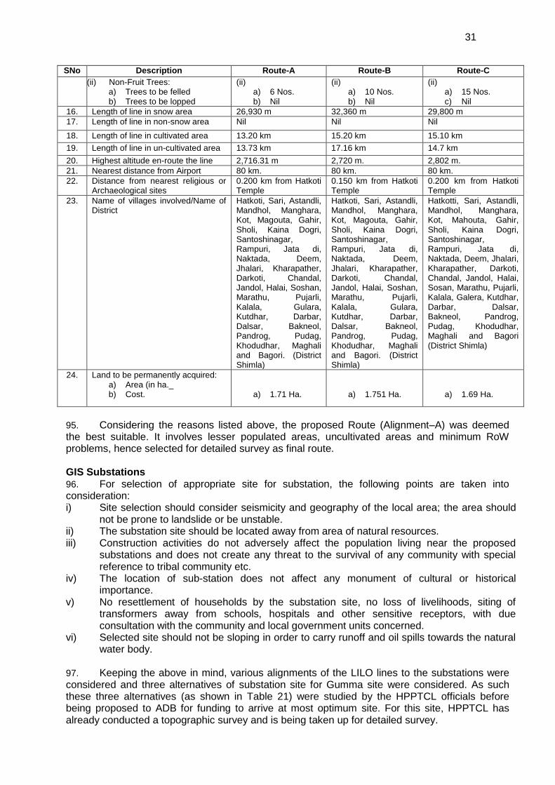
31
SNo Description Route-A Route-B Route-C
(ii) Non-Fruit Trees: a) Trees to be felled b) Trees to be lopped
(ii) a) 6 Nos. b) Nil
(ii) a) 10 Nos. b) Nil
(ii) a) 15 Nos. c) Nil
16. Length of line in snow area 26,930 m 32,360 m 29,800 m
17. Length of line in non-snow area Nil Nil Nil
18. Length of line in cultivated area 13.20 km 15.20 km 15.10 km
19. Length of line in un-cultivated area 13.73 km 17.16 km 14.7 km
20. Highest altitude en-route the line 2,716.31 m 2,720 m. 2,802 m.
21. Nearest distance from Airport 80 km. 80 km. 80 km.
22. Distance from nearest religious or Archaeological sites
0.200 km from Hatkoti Temple
0.150 km from Hatkoti Temple
0.200 km from Hatkoti Temple
23. Name of villages involved/Name of District
Hatkoti, Sari, Astandli, Mandhol, Manghara, Kot, Magouta, Gahir, Sholi, Kaina Dogri, Santoshinagar, Rampuri, Jata di, Naktada, Deem, Jhalari, Kharapather, Darkoti, Chandal, Jandol, Halai, Soshan, Marathu, Pujarli, Kalala, Gulara, Kutdhar, Darbar, Dalsar, Bakneol, Pandrog, Pudag, Khodudhar, Maghali and Bagori. (District Shimla)
Hatkoti, Sari, Astandli, Mandhol, Manghara, Kot, Magouta, Gahir, Sholi, Kaina Dogri, Santoshinagar, Rampuri, Jata di, Naktada, Deem, Jhalari, Kharapather, Darkoti, Chandal, Jandol, Halai, Soshan, Marathu, Pujarli, Kalala, Gulara, Kutdhar, Darbar, Dalsar, Bakneol, Pandrog, Pudag, Khodudhar, Maghali and Bagori. (District Shimla)
Hatkotti, Sari, Astandli, Mandhol, Manghara, Kot, Mahouta, Gahir, Sholi, Kaina Dogri, Santoshinagar, Rampuri, Jata di, Naktada, Deem, Jhalari, Kharapather, Darkoti, Chandal, Jandol, Halai, Sosan, Marathu, Pujarli, Kalala, Galera, Kutdhar, Darbar, Dalsar, Bakneol, Pandrog, Pudag, Khodudhar, Maghali and Bagori (District Shimla)
24. Land to be permanently acquired: a) Area (in ha._ b) Cost.
a) 1.71 Ha.
a) 1.751 Ha.
a) 1.69 Ha.
95. Considering the reasons listed above, the proposed Route (Alignment–A) was deemed the best suitable. It involves lesser populated areas, uncultivated areas and minimum RoW problems, hence selected for detailed survey as final route. GIS Substations 96. For selection of appropriate site for substation, the following points are taken into consideration: i) Site selection should consider seismicity and geography of the local area; the area should
not be prone to landslide or be unstable. ii) The substation site should be located away from area of natural resources. iii) Construction activities do not adversely affect the population living near the proposed
substations and does not create any threat to the survival of any community with special reference to tribal community etc.
iv) The location of sub-station does not affect any monument of cultural or historical importance.
v) No resettlement of households by the substation site, no loss of livelihoods, siting of transformers away from schools, hospitals and other sensitive receptors, with due consultation with the community and local government units concerned.
vi) Selected site should not be sloping in order to carry runoff and oil spills towards the natural water body.
97. Keeping the above in mind, various alignments of the LILO lines to the substations were considered and three alternatives of substation site for Gumma site were considered. As such these three alternatives (as shown in Table 21) were studied by the HPPTCL officials before being proposed to ADB for funding to arrive at most optimum site. For this site, HPPTCL has already conducted a topographic survey and is being taken up for detailed survey.
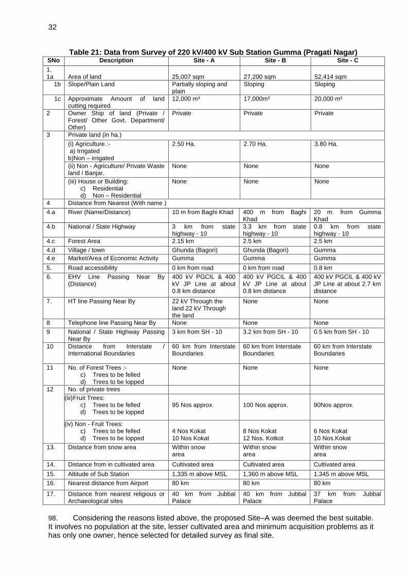
32
Table 21: Data from Survey of 220 kV/400 kV Sub Station Gumma (Pragati Nagar) SNo Description Site - A Site - B Site - C
1. 1a
Area of land
25,007 sqm
27,200 sqm
52,414 sqm
1b Slope/Plain Land Partially sloping and plain
Sloping Sloping
1c Approximate Amount of land cutting required
12,000 m³
17,000m³ 20,000 m³
2 Owner Ship of land (Private / Forest/ Other Govt. Department/ Other)
Private Private Private
3 Private land (in ha.)
(i) Agriculture :- a) Irrigated b)Non – irrigated
2.50 Ha. 2.70 Ha. 3.80 Ha.
(ii) Non - Agriculture/ Private Waste land / Banjar.
None None None
(iii) House or Building: c) Residential d) Non – Residential
None None None
4 Distance from Nearest (With name )
4.a River (Name/Distance) 10 m from Baghi Khad 400 m from Baghi Khad
20 m. from Gumma Khad
4.b National / State Highway 3 km from state highway - 10
3.3 km from state highway - 10
0.8 km from state highway - 10
4.c Forest Area 2.15 km 2.5 km 2.5 km
4.d Village / town Ghunda (Bagori) Ghunda (Bagori) Gumma
4.e Market/Area of Economic Activity Gumma Gumma Gumma
5. Road accessibility 0 km from road 0 km from road 0.8 km
6. EHV Line Passing Near By (Distance)
400 kV PGCIL & 400 kV JP Line at about 0.8 km distance
400 kV PGCIL & 400 kV JP Line at about 0.8 km distance
400 kV PGCIL & 400 kV JP Line at about 2.7 km distance
7. HT line Passing Near By 22 kV Through the land 22 kV Through the land
None None
8 Telephone line Passing Near By None None None
9
National / State Highway Passing Near By
3 km from SH - 10 3.2 km from SH - 10 0.5 km from SH - 10
10 Distance from Interstate / International Boundaries
60 km from Interstate Boundaries
60 km from Interstate Boundaries
60 km from Interstate Boundaries
11 No. of Forest Trees :- c) Trees to be felled d) Trees to be lopped
None None None
12 No. of private trees
(iii) Fruit Trees: c) Trees to be felled d) Trees to be lopped
95 Nos approx.
100 Nos approx.
90Nos approx.
(iv) Non - Fruit Trees: c) Trees to be felled d) Trees to be lopped
4 Nos Kokat 10 Nos Kokat
8 Nos Kokat 12 Nos. Kotkot
6 Nos Kokat 10 Nos.Kokat
13. Distance from snow area Within snow area
Within snow area
Within snow area
14. Distance from in cultivated area Cultivated area Cultivated area Cultivated area
15. Altitude of Sub Station 1,335 m above MSL 1,360 m above MSL 1,345 m above MSL
16. Nearest distance from Airport 80 km 80 km 80 km
17. Distance from nearest religious or Archaeological sites
40 km from Jubbal Palace
40 km from Jubbal Palace
37 km from Jubbal Palace
98. Considering the reasons listed above, the proposed Site–A was deemed the best suitable. It involves no population at the site, lesser cultivated area and minimum acquisition problems as it has only one owner, hence selected for detailed survey as final site.
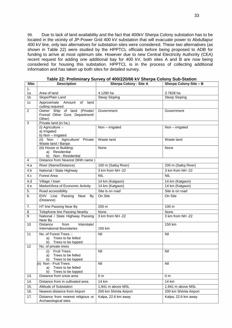
33
99. Due to lack of land availability and the fact that 400kV Sherpa Colony substation has to be located in the vicinity of JP-Power Grid 400 kV substation that will evacuate power to Abdullapur 400 kV line, only two alternatives for substation sites were considered. These two alternatives (as shown in Table 22) were studied by the HPPTCL officials before being proposed to ADB for funding to arrive at most optimum site. However due to new Central Electricity Authority (CEA) recent request for adding one additional bay for 400 kV, both sites A and B are now being considered for housing this substation. HPPTCL is in the process of collecting additional information and has taken up both sites for detailed survey.
Table 22: Preliminary Survey of 400/220/66 kV Sherpa Colony Sub-Station SNo Description Sherpa Colony - Site A Sherpa Colony Site – B
1. 1a
Area of land
4.1280 ha
3.7828 ha
1b Slope/Plain Land Steep Sloping Steep Sloping
1c Approximate Amount of land cutting required
2 Owner Ship of land (Private/ Forest/ Other Govt. Department/ Other)
Government Government
3 Private land (in ha.)
(i) Agriculture :- a) Irrigated b) Non – irrigated
Non – irrigated Non – irrigated
(ii) Non - Agriculture/ Private Waste land / Banjar.
Waste land Waste land
(iii) House or Building: a) Residential b) Non - Residential
None None
4 Distance from Nearest (With name )
4.a River (Name/Distance) 100 m (Satluj River) 200 m (Satluj River)
4.b National / State Highway 3 km from NH -22 3 km from NH -22
4.c Forest Area NIL NIL
4.d Village / town 14 km (Katgaon) 14 km (Katgaon)
4.e Market/Area of Economic Activity 14 km (Katgaon) 14 km (Katgaon)
5. Road accessibility Site is on road Site is on road
6. EHV Line Passing Near By (Distance)
On Site On Site
7. HT line Passing Near By 200 m 100 m
8 Telephone line Passing Nearby None None
9
National / State Highway Passing Near By
3 km from NH -22 3 km from NH -22
10 Distance from Interstate/ International Boundaries
150 km 150 km
11 No. of Forest Trees :- a) Trees to be felled b) Trees to be lopped
Nil Nil
12 No. of private trees
(i) Fruit Trees: a) Trees to be felled b) Trees to be lopped
Nil Nil
(ii) Non - Fruit Trees: a) Trees to be felled b) Trees to be lopped
Nil Nil
13. Distance from snow area 0 m 0 m
14. Distance from in cultivated area 14 km 14 km
15. Altitude of Substation 1,941 m above MSL 1,941 m above MSL
16. Nearest distance from Airport 200 km Shimla Airport 200 km Shimla Airport
17. Distance from nearest religious or Archaeological sites
Kalpa, 22.6 km away Kalpa, 22.6 km away
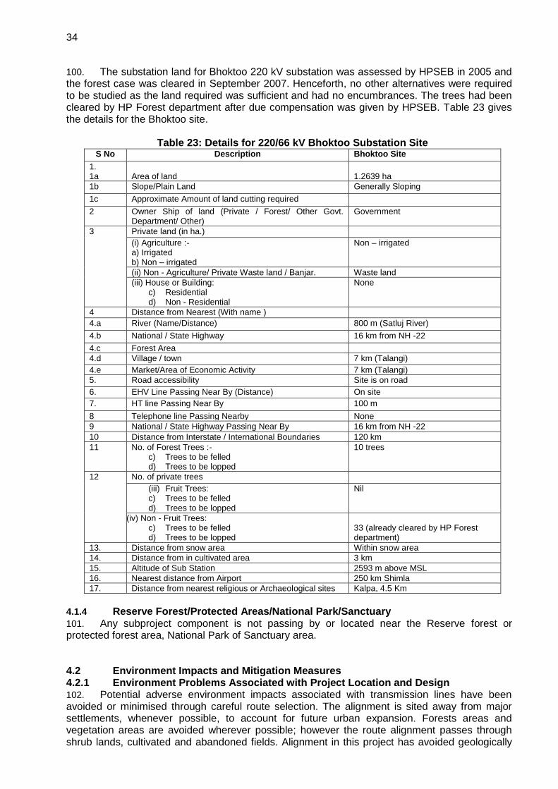
34
100. The substation land for Bhoktoo 220 kV substation was assessed by HPSEB in 2005 and the forest case was cleared in September 2007. Henceforth, no other alternatives were required to be studied as the land required was sufficient and had no encumbrances. The trees had been cleared by HP Forest department after due compensation was given by HPSEB. Table 23 gives the details for the Bhoktoo site.
Table 23: Details for 220/66 kV Bhoktoo Substation Site S No Description Bhoktoo Site
1. 1a
Area of land
1.2639 ha
1b Slope/Plain Land Generally Sloping
1c Approximate Amount of land cutting required
2 Owner Ship of land (Private / Forest/ Other Govt. Department/ Other)
Government
3 Private land (in ha.)
(i) Agriculture :- a) Irrigated b) Non – irrigated
Non – irrigated
(ii) Non - Agriculture/ Private Waste land / Banjar. Waste land
(iii) House or Building: c) Residential d) Non - Residential
None
4 Distance from Nearest (With name )
4.a River (Name/Distance) 800 m (Satluj River)
4.b National / State Highway 16 km from NH -22
4.c Forest Area
4.d Village / town 7 km (Talangi)
4.e Market/Area of Economic Activity 7 km (Talangi)
5. Road accessibility Site is on road
6. EHV Line Passing Near By (Distance) On site
7. HT line Passing Near By 100 m
8 Telephone line Passing Nearby None
9 National / State Highway Passing Near By 16 km from NH -22
10 Distance from Interstate / International Boundaries 120 km
11 No. of Forest Trees :- c) Trees to be felled d) Trees to be lopped
10 trees
12 No. of private trees
(iii) Fruit Trees: c) Trees to be felled d) Trees to be lopped
Nil
(iv) Non - Fruit Trees: c) Trees to be felled d) Trees to be lopped
33 (already cleared by HP Forest department)
13. Distance from snow area Within snow area
14. Distance from in cultivated area 3 km
15. Altitude of Sub Station 2593 m above MSL
16. Nearest distance from Airport 250 km Shimla
17. Distance from nearest religious or Archaeological sites Kalpa, 4.5 Km
4.1.4 Reserve Forest/Protected Areas/National Park/Sanctuary
101. Any subproject component is not passing by or located near the Reserve forest or protected forest area, National Park of Sanctuary area. 4.2 Environment Impacts and Mitigation Measures 4.2.1 Environment Problems Associated with Project Location and Design 102. Potential adverse environment impacts associated with transmission lines have been avoided or minimised through careful route selection. The alignment is sited away from major settlements, whenever possible, to account for future urban expansion. Forests areas and vegetation areas are avoided wherever possible; however the route alignment passes through shrub lands, cultivated and abandoned fields. Alignment in this project has avoided geologically
35
unstable areas, which can also pose foundation related problems. No land acquisition is required for placing transmission towers on private land. However, any damage to the crops during the construction phase of the project will be duly compensated. Associated impacts on agricultural land will be restricted to the construction phase and will be temporary in nature. After construction, agricultural land within the transmission corridors can be used again for farming purpose of crops less than 3 m in height. 4.2.2 Environmental Impacts Associated with Pre-Construction Stage
4.2.2.1 Acquisition of Cultivable and Non cultivable lands 103. There may be loss of agricultural productivity due to obstructions and reduced land availability. Thus the following measures will have to be taken prior to the project activities:
Avoid farming season wherever possible for the project activities,
Ensure existing irrigation facilities are maintained in working condition,
Protect /preserve topsoil and reinstate after construction is completed,
Repair /reinstate damaged bunds after construction is completed, and
Compensation for temporary loss in agricultural production. 4.2.2.2 Impacts on Temporary Use of Land 104. The construction equipment and construction materials will require proper space for storage, parking space for construction vehicles and equipment, construction material storage, and labour camp to avoid environmental impact and public inconvenience. These locations must comply with the local laws and regulations and need approval from authorities to utilise these facilities (access roads, telecommunication, and pipe borne water supply). It is important that selection of temporary lands is at least 500 m away from highly populated areas, water bodies, natural flow paths, agricultural lands, important ecological habitats and residential areas. Removal of trees and green cover vegetation should be minimised during preparation of facilities. 4.2.3 Environmental Problems Associated with Construction and Operation Stage
105. The project activities during construction phase will involve clearing of trees along the route alignment wherever required, excavation for installation of towers, erection of towers, civil works related to transmission line and line stringing. For substations, it will involve excavation for building and equipment foundations, civil works and erection of equipment. During the operation phase, most of the construction phase impacts will get stabilised and the impacts will be restricted only to the operation and maintenance of the project. 106. The impacts on the environment from various activities of the project can be categorised as follows:
Impact on Physical Resources o Impact on Topography o Impact on Climate
Impact on Environmental Resources o Impact on Air Quality o Impact on Noise Levels o Impact on surface Water Quality o Impact on ground Water Quality o Impact on Soils and Geology
Impact on Ecological Resources o Terrestrial Ecology o Wild Life o Aquatic Ecology
Impact on Human Environment o Health and Safety o Agriculture o Socio-economics o Resettlement and Rehabilitation
36
o Cultural sites o Traffic and Transport o Interference with other utilities and traffic
Waste Disposal o Solid waste disposal o Liquid waste disposal.
107. The impacts of the project activities on various environmental attributes are discussed in subsequent sections. 4.2.3.1 Impact on Physical Resources Impact on Topography 108. During the construction of the transmission line and substation, the topography will change due to excavation and erection of tower, fill and cut for levelling the tower erection place. The most prominent impact on the surface topography will be due to the removing of the trees at the tower erection site if required, along the Right-of-Way (RoW). This will lead to change in the surface features only. The impact will be irreversible as the present features along the RoW will be changed due to presence of the transmission line. 109. No topographical changes are envisaged during the operation phase of the transmission line and the substation. The existing access routes will be utilised during the operation and maintenance of the transmission lines. Impact on Climate 110. The project area consists of both cultivated and uncultivated lands which grow predominantly single season crops during the monsoons. There will be no large scale removal of trees/cultivation and therefore there will be no impact on the climate conditions from the proposed project both during the construction and operation phases. 4.2.3.2 Impact on Environmental Resources Impact on Air Quality 111. During the construction phase, the activity would involve excavation for the tower erection, movement of vehicles carrying the construction materials along the haul roads. At majority of tower locations, movement by vehicle is not possible from approach road to construction site and the material has to be head loaded. All these activities would give rise to emission of dust particles thereby affecting air quality marginally at the site. The impact will be transitory in nature and therefore is assessed as of low significance. Covering of stockpiles, minimising double handling and drop loads as well as sprinkling of water during excavation will reduce the dust emission to a great extent. 112. The construction of transmission line and the substation will not have any negative impact on the air quality of the region during the operation phase. Impact on Noise Levels 113. During the construction phase, the major sources of noise pollution are movement of vehicles carrying the construction material and equipment to the site. Most of the access roads along the alignment are motor able and project traffic would be negligible. The major work of the construction is expected to be carried out during the day time. Apart from vehicles bringing in materials to the nearest road, construction works for the transmission line will not require powered equipment. As such, noise emissions will be minor. As the predominant land use along most part of the alignment is agricultural, there will be few residential areas exposed to noise generated during the construction phase and the noise produced during the construction period will have negligible impact on residents. 114. Following measures will help to keep noise and vibration in acceptable level during construction phase:
Contractor shall preferably limit working time for activities that create noise within normal
37
waking hours of the public except for construction site near public sensitive receptors. Construction related activities closer to sensitive receptors have to be scheduled in coordination with the relevant authorities and community.
Noisy equipment such as generators should be sited away from residential areas.
Contractor and suppliers of construction materials should strictly implement noise control regulations stipulated by the Noise Pollution (Regulation and Control Rules 2000) for all construction vehicles and equipment.
At substation sites, contractor shall equip their heavy construction equipment and plants with exhaust silencers to limit the engine noise not to exceed 75 dB (compacters/rollers, loaders and cranes) and regularly maintain all construction vehicles and machinery that should meet the National Emission Standards.
Impact on Surface Water Quality 115. The construction and operation of the transmission lines will not have any major impact on the surface and ground water quality in the area. Contamination of water bodies may result due to spilling of construction materials and surface runoff from the construction site joining the water body. There may be increase in the turbidity levels temporarily where the proposed alignment is crossing a watercourse and if the surface runoff during construction meets the river. This can be avoided by careful selection of the tower site so that the surface runoff does not meet the river. 116. Proposed activities will create temporary impacts to the existing drainage system in the area including irrigation canals, natural flow paths and also earth and line drains. Thus incorporation of following measures will minimise anticipated impact due to obstruction of natural flow paths and existing drainage:
Provisions of temporary drainage facilities and routing ponds to the particular locations if existing drains are obstructed due to construction activities
Maintenance of all drainage paths by avoiding blockages at all times
Contractor should minimise excavation of beds of any streams, irrigation systems, and other water resources available in the project affected area.
Stagnant water should be cleared by the contractor. 117. Care shall be taken to locate the temporary construction worker sheds away from the water bodies. Adequate drinking water facilities, sanitary facilities and drainage in the temporary sheds of construction workers should be provided to avoid the surface water pollution. Provision of adequate washing and toilet facilities should be made obligatory. This should from an integral component in the planning stage before commencement of construction activity. Operation of transmission lines will not cause any release to the surface water bodies. Impact on Hydrology and Water Resources 118. Water needs during construction of the Project would be limited to sanitary water and minimal amounts of water for construction (such as spraying for dust prevention). This would be a negligible impact on water resources. Operation of the lines would not require any water. Impact on Ground Water Quality 119. Ground water pollution can take place, if chemical substances and oily waste get leached by precipitation of water and percolate to the ground water table. For transmission line construction activity, no chemical substance or oil is used hence there is no impact on ground water quality. The silt discharge from the earth work around water bodies, oil, grease and fuel release from the construction vehicles/equipment and spoil from construction and other construction related activities such as raw sewerage from worker accommodation sites will mix with runoff water. This situation will increase during the rainy season and could have a significant impact on surface and ground water. Thus following measures will be required in order to prevent deterioration of water from the construction and construction related activities:
All construction vehicles and equipment should be maintained in proper conditions without any leakages,
Contractors shall use silt traps and erosion control measures where the construction is carried out in close proximity to the water bodies to avoid entering of cement particles, rock, rubbles
38
and waste water to the surrounding water bodies,
Construction activities requiring digging should be preferably done in the dry season, and
Waste oil should be collected properly and disposed to the approved recyclers. Impact on Soil and Geology 120. Project activities including excavation, cut and fill operations, removal of trees and green cover vegetation will enhance the soil erosion during the rainy season. Removal of trees and green cover vegetation will reduce infiltration rate of rainwater. The impact on soils will be due to the soil erosion at the tower construction sites along the access routes. The excavation activity and land clearance in the erosion prone areas have been minimised while conducting the site selection for towers. Revetment and stabilisation of tower construction sites will be done after completion of construction activity. Also increased acceleration of surface runoff will damage the topsoil. The impacts associated with excessive erosion and other civil works can be avoided or minimised by following mitigation measures:
Maximum effort should be taken to minimise removal of trees and green cover vegetation.
Minimise obstruction or destruction to natural drainage pattern of the surrounding area.
Proper treatment of clearing and filling areas against flow acceleration.
Turfing work should be taken prior to rainy season around the substation.
Contractors shall follow proper muck disposal plan for cut and fill operation around sharp/deep slope areas.
Piling activities will preferably be done in non-rainy season, as the piled materials will spread all over the area and contaminate close by water bodies.
Top soil (2-3 cm from the top of the soil), which are removed during construction from the cultivated lands must be stored separately for future utilisation of cultivated lands near tower leg locations.
4.2.3.3 Impact on Ecological Resources 121. Since sub-station is constructed in vacant government/private land and transmission line is routed away from the inhabited areas, there is no displacement of people or animals. It is also not causing any disturbance to the life of people and local animals and birds movement. In transmission line construction, there is no dynamic equipment and moving machinery causing noise pollution, water and air pollution. There is no national wildlife park, bird sanctuary, wetland in the route alignment of the proposed transmission line. The ecological impacts are briefly described in the following sections.
Effect on Flora and Fauna 122. On visual inspection, it appears that forest and fruit trees will need to be removed from the project area for the RoW which will be removed by getting prior permission from forest and horticulture department of HP state (35m ROW for 220 kV line). None of the declared environmentally sensitive areas is located within the route alignment. It is not expected that any flora and fauna that are rare, endangered, endemic or threatened will be affected. Migratory paths of small mammals and reptiles may be affected due to construction activities. However noise, vibration and emission from construction vehicles, equipment will occur during construction and pre-construction stages in temporary manner. The impacts related to above activities are temporary and can be mitigated through following measures:
Strict attention on worker force regarding disturbance to surrounding habitats, flora and fauna including hunting of animals and fishing in water bodies,
Selection of approved locations for material storage yards and labour camps away from the environmental sensitive areas, and
Avoid entering of construction waste (cement particles, rock, rubbles and waste water) and sanitary waste to the surrounding water bodies.
Impact on Terrestrial Ecology 123. There is no sensitive ecological area / protected forest area such as national wildlife park, bird sanctuary crossing the proposed route alignment. The removal of herbaceous vegetation
39
from the soil and loosening of the top soil generally causes soil erosion. However, such impacts would be primarily confined to the project site during initial periods of the construction phase and would be minimised through adoption of mitigation measures like paving and surface treatment and water sprinkling. Removal of Trees 124. All fruit/non-fruit trees will need to be removed during the line construction. Table 24 gives the list of trees to be cut for tranche 1 subprojects. The initial construction works along the alignment involving land clearance, cutting, filling, and levelling that may cause loss of vegetation. This will be an irreversible impact. Care has been taken to avoid the thick plantations/vegetation as far as possible and tower locations are selected mostly in plain cultivable fields where the vegetation is thin. This will minimise the tree loss. Compensation will be paid to tree owners in the private areas as per GoI norms. Where the clearing of fields and forest area is unavoidable along the route alignment, the compensatory afforestation will be required for forest areas for which clearance will be obtained from the appropriate authority of the forest department; and for fruit and non-fruit trees in the fields, the amount for compensation for fields will be paid direct to the farmers.
Table 24: Number of trees need to be cut for tranche - 1 subprojects Sub-Project Total Number of fruit tree
to be cut Total Number of Non
fruit tree to be cut Total Number of forest
tree to be cut
220 kV Hatkoti – Gumma Line 484 6 162 220/400 kV GIS Pooling station Substation, Gumma
95 14 Nil
400/220/66 kV GIS Pooling station, near Sherpa Colony, Wangtoo
Nil Nil Nil
220/66 kV GIS Pooling Station, Bhoktoo
Nil Nil 33 trees cut*
* Forest case awarded in September 2007.
Effect on Local Road Network 125. Transformers, tower material, substation equipment, iron bars, concrete materials, piling equipment, will be transported through the provincial and local road network to the project site. Transporting of large quantities of materials using heavy vehicles could exceed the carrying capacity of the road. This would lead to physical damages to local road network. Thus, it will be necessary to obtain consent from Public Works Department (PWD) or National Highway Authority to use local/national highway roads prior to transportation. Also contractor should properly maintain all road sections, which will be utilised for the construction related activities.
Disposal of Debris 126. As a result of construction related activities, spoil and debris will be generated during the construction stage. Improper disposal of the debris will have an impact on the surrounding ecology, public health and scenic beauty. Following measures will minimise the impacts associated with disposal of debris:
Spoil materials (soil, sand, rock) generated from construction activities shall be used wherever possible for site levelling, back - filling. Dismantled and demolished structural materials, if any, should not be dumped at agricultural lands
Preparation of a Muck Disposal Management Plan for the sub-project and selection of the disposal site by excluding locations, which are closer to residential, commercial and public sensitive areas, is necessary by the contractor. Prior approval should be obtained for such dumping grounds / land fill sites from relevant local authorities
Dumped materials will interfere with the drainage pattern of the area, any water bodies, agricultural lands, marshlands and down slope or any environmental sensitive areas if not planned properly.
127. During operation phase, corridor along the alignment will be chopped of vegetation and lopping of trees will be done for maintenance purpose. This will also reduce the chances of fires due to electric sparks.
40
Wild Life 128. For selecting the route alignment, any wild life travel routes have been avoided as far as possible during the field visits. 129. Rupi Bhaba Sanctuary is 60 km from the 220/400 kV transmission systems line and would not cause impact on the environment. Similarly the substations are also located at a sufficient distance from the Reserved Forest Area and will not negatively impact the flora and fauna of the area. Impact on Aquatic Ecology 130. The proposed transmission line would cross over the Pabbar river and small streams which are usually perennial in nature. No significant impacts on aquatic ecology of the river are envisaged, as there will be careful selection of the construction time and tower sites near the river, to avoid the river pollution and disturbance to the aquatic fauna of the area during the monsoon period. 4.2.3.4 Impact on Human Environment Health and Safety 131. Project activities could impact the health and safety of the work force and of the general public, in particular, in terms of risk of accidents and exposure to electromagnetic fields along the alignment. The accidents may be caused due to electro-cutting, lightening, fires and explosions. To avoid this, the houses will not be allowed within the RoW of the project.
132. Project activities may create accidental damage to general public and the construction workers. Therefore, contractors should take necessary action to enhance personal safety during the construction through following measures:
Organise awareness programmes relevant to personal safety of the workers and general public in the area.
Installation of warning signs to particular locations such as transverse points of local road network by transmission lines.
Provide protective safety belts, footwear, helmets, goggles, eye-shields and clothes to workers depending on their duty.
Arrangement of proper first aid unit and transport facilities to take injured people to the hospitals.
Workers should be covered by the statutory Workmen Compensation as per GoI laws by the contractor.
Agriculture 133. Permanent and temporary loss of agricultural land occurs due to tower location in the agricultural field and loss of crop for access routes. As per standard HP policy, approximately 225 sq.m. land will acquired for each tower erection, besides private land required for Gumma Substation. As far as possible, the prime agricultural land will be avoided and the construction will be done after crop harvesting. Socio-Economics 134. Construction of transmission line will generate local employment, as number of unskilled labours (men/women) will be required at the time of construction activities. Local employment during this period will increase socio-economic standards. Temporary Outage of the Electricity 135. Temporary disconnection of power supply will occur during the construction activities. Thus, general public and the industrial places, which are located in project-affected area, will face inconvenience for short periods of time. Thus following measures will have to be taken:
Advance notice to the public about the time and the duration of the utility disruption, and
Restore the utilities immediately to overcome public inconvenience.
41
Resettlement and Rehabilitation 136. For the construction of transmission line and one substation, land acquisition is required. The detail of resettlement and rehabilitation involved in the project are given in Resettlement Planning document prepared separately for Tranche 1. Cultural sites 137. There are no archaeological, historical or cultural important sites along the route alignment, hence no impact on these sites is envisaged. In the case of discovery of archaeological features during excavation/construction works, GOI’s regulations shall apply and will be observed by contractors. Traffic and Transport 138. During the construction phase, traffic disturbance needs to be minimised by avoiding high-density areas, using proper traffic signs, ensuring proper access roads and avoiding road blockage. Interference with Other Utilities and Traffic 139. A standing committee - Power Telecom Co-ordination Committee (P.T.C.C.) has been constituted by Government of India to plan and implement the mitigating measures for the induced voltage, which may occur to nearby telecom circuits and suggest necessary protection measures to be adopted. The committee suggests measures like rerouting of the telecom circuits, conversion of overhead telecom circuits into cables etc. to minimize the interference. It is mandatory for HPPTCL to seek clearance prior to construction from Telecommunications and wherever necessary from aviation authorities that are likely to be affected by the construction of transmission lines. The transmission lines affect nearby telecommunication circuits by causing electrical interference and induced voltage which may occur to nearby telecom circuit and suggested necessary protection measures will need to be adopted. This may require measures like rerouting of the telecom circuits, conversion of overhead telecom circuits into cables to minimise the interference. The exact cost to mitigate the impacts of induction in neighbouring telecom circuits would vary from case to case. In general, the system is planned and executed in such a way that adequate clearance is maintained between transmission lines on the one hand, and railways, civil aviation and defense installations on the other. Wherever the transmission lines passes near the airport, the towers beyond specified height are painted in alternate orange and white stripes for easy visibility and warning lights are placed on the top of these towers. 4.2.3.5 Waste Disposal Solid Waste Disposal 140. The solid waste generation at the location of the tower erection site will mostly include metal scraps, wooden packing material. Waste will be minimised and recycled wherever possible. Final waste will be collected and disposed off in compliance with applicable GoI/GoHP regulations and rules by the contractor. Sanitary Waste Disposal at Construction Sites and Labour Camps 141. The labour camps at the site of tower erection will be temporary in nature and the human excreta will not be significant to cause contamination of ground water. Those places where most labour will be staying will be near hamlets which shall use the community services for solid waste, water and sanitation. Adequate drinking water facilities, sanitary facilities and drainage in the temporary sheds of the construction workers should be provided to avoid the surface water pollution. This should form an integral component in the planning stage before commencement of construction activity. 142. Thus following measures are needed to protect and enhance the quality of environment during the construction stage:
Provision of the solid waste disposal, sanitation and sewage facilities at all substation sites for the construction/labour camps to avoid or minimise health hazards and environmental pollution.
Contractor should handle and manage waste generated from the construction/labour camps without contamination to natural environment and it will reduce risk to general public who stay
42
close to sites. Also contractor should be responsible to enhance the quality of environment.
Adequate supply of water should be provided to the urinals, toilets and wash rooms of the workers’ accommodation.
Liquid Waste Disposal 143. There will be no oil or chemical waste generated during the construction of transmission line, hence no mitigation is required. 4.2.4 Environmental Impacts Associated with Operations and Maintenance Stage Electric Shock 144. This may lead to death or injury to the workers and public in the area. This can be minimised or avoided by:
Security fences around substation
Establishment of warning signs
Careful design using appropriate technologies to minimise hazards. Noise Generation 145. During the operation phase of the project, there may be corona noise from the conductors which will be felt only up to 15 to 30 m area, hence the ambient noise level will meet the CPCB standard for residential areas (55 dB(A) during daytime and 45 dB(A) during night time. Maintenance of Transmission Line and Substation 146. Possible exposure to electromagnetic interference could occur during these activities. Design of transmission line should comply with the limits of electromagnetic interference from overhead power lines. Oil Spillage 147. Contamination of water on land/nearby water bodies by the transformer oil can occur during operation due to leakage or accident. Substation transformers are normally located within secure and impervious areas with a storage capacity of 100% spare oil. Also proper drainage facilities will be constructed during the construction stage to avoid overflow or contamination with natural flow paths especially during the rainy season. HPPTCL will maintain account of the usage of oil, using technical methods and procedures for oil monitoring mechanism, and will have mitigation plan for any oil spillage. Sulphur Hexa fluoride (SF6) Leakage 148. SF6 is a non-toxic greenhouse gas used as a dielectric in circuit breakers, switch gear, and other electrical equipment. Very high grade sealing system and erection methodology to keep the loss of SF6 within 0.1% every year. SF6 handling is part of each contracts technical specifications, and required design and routine test are done after manufacturing of the circuit breaker. SF6 gas handling system for evacuation and storage is always used for the maintenance of the circuit breaker. SF6 gas leakage records will be maintained in each substation. This allows tracking of any release of SF6 gas to the atmosphere. 4.3 Environmental Management Plan 149. Based on the environmental assessment of the project activities, an Environment Management Plan (EMP) has been developed for the project to mitigate the adverse environmental impacts. The EMP discusses anticipated impacts and mitigation measures and monitoring requirements and responsible authorities to implement the EMP with respect to the following stages: (i) pre-construction, (ii) construction, and (iii) operation and maintenance. Detailed, site-specific mitigation measures and monitoring plans were developed and will be implemented during the project implementation phase. 150. The EMP for the project is attached as Annex 3, which identifies feasible and cost-effective measures to be taken to reduce potential significant, adverse, impacts to acceptable levels. A summary environmental impact matrix and the mitigation measures are given in Table 25.

43
Table 25: Environmental Impact Matrix Sl. Nº Environment
al attribute Potential impacts Nature of
impact Magnitude of impacts Mitigation measures Implementation
and Monitoring Low Medium High
A. Physical Resources
1. Topography Change in the surface features and present aesthetics due to the construction of the project.
Direct/Local/ irreversible
X The surface soil will be restored to normal slope after tower erection. If there is any excess soil, it shall be disposed off at suitable location. Any loss of vegetation will be attended by HPPTCL as per existing GOHP norms Within the substation, the excess soil from be disposed off in consultation with HPPTCL as per EMP
During construction activity
2. Climate No impact on the climatic conditions
Direct/Local/ irreversible
X No impact on the climatic conditions, hence no mitigation is required
Monitoring of SF6 gas from Electrical Substations
Direct/Local/ irreversible
X Proper record of all SF6 leakages in substations kept for record
During Construction and Operation
B. Environmental Resources
1. Air Quality Project will have marginal impact on air quality during the construction period due to increase in the dust emission.
Direct/Local/ reversible
X Watering at construction site, limited bare soils, maintenance of vehicles.
During construction activity
2. Noise Noise due to general construction activities.
Direct/Local/ reversible
X Restriction of noise generating activities at night and use of personal protective equipment like ear plugs, mufflers.
During construction activity
Noise arising from corona noise from conductors
Direct/Local/ reversible
X Monitoring of possible corona noise to identify and correct problems.
During operational phase
3. Surface and Ground Water quality
Runoff from the construction site
Direct/Local/ reversible
X Careful sitting of towers, and access roads.
Before and during construction activity
Domestic wastewater from construction sites
Direct/Local/ reversible
X Domestic waste treatment by providing septic tank/soak pits at Substation. For tower locations, it will be temporary sites.
During construction and operation
4. Soils and Geology
Soil erosion due to tower erecting and clearing of
Direct/Local/ reversible
X Avoiding sites, which are prone to soil erosion. Levelling of tower
During and after the construction activity

44
Sl. Nº Environmental attribute
Potential impacts Nature of impact
Magnitude of impacts Mitigation measures Implementation and Monitoring Low Medium High
vegetation in the RoW and access roads.
construction sites. Use of few access roads. Rehabilitation and stabilisation of disturbed land at the substations.
Damage due to seismic activity
Direct/regional/ reversible
X Site selection and proper tower foundation design considering the geological conditions and seismicity of the area.
Before the construction activity.
C. Ecological Resources
1. Terrestrial Ecology
Loss of vegetation Direct/Local/ irreversible
X Location of towers on non-cultivable land area. Selection of few access roads. Compensation for crop and trees to villagers. The tree planting for each tree cleared along the route alignment (if required) will be done by the forest department and paid by HPPTCL
Before the construction phase
2. Terrestrial Fauna
Disturbance to the local fauna during construction
Direct/Local/ reversible
X Wildlife routes and their habitats have been avoided as far as possible during the route selection. Minimise encroachments, and indirect impacts.
Before and during construction phase
Avifauna Disturbance to the local fauna during operation
Direct/Local/ reversible
X Monitoring of line especially for bird strikes during the operation and use of deflectors if required.
During operation phase
3. Aquatic Ecology
No significant impacts envisaged
Direct/Local/ reversible
X Disposal of construction waste and other waste to avoid polluting the river and streams
Before and during construction phase
D. Human Environment
1 Fires, explosion and other accidents at the route alignment of transmission line.
Direct/Local X Use of personal protective equipment during construction. By lopping and chopping of trees fire hazards will be minimised during maintenance period. Regular inspection of lines for faults prone to accidents.
During construction and operation phase
2. Health and Safety
Exposure to electromagnetic fields
Direct/Local/ continuous
X Alignment route away from the settlement. No houses in the immediate vicinity and will be
Before and after the construction phase.

45
Sl. Nº Environmental attribute
Potential impacts Nature of impact
Magnitude of impacts Mitigation measures Implementation and Monitoring Low Medium High
allowed in the RoW of the alignment. No further mitigation required.
3. Agriculture Permanent and temporary loss of agriculture land due to tower erection and due to access routes.
Direct/Local/ reversible
X Avoid prime agriculture land. Assessment of land required and compensation. Construction activity after crop harvesting and selection of few access routes.
Before and during construction phase.
4. Socio-economics
Beneficial impacts job opportunities during construction phase
Direct/regional
X Unskilled labour and indirect benefits. Overall economic growth of the region.
During operational phase
5. Resettlement Resettlement of any house falling along the RoW.
Direct/Local/ reversible
X Route alignment is selected in such a way that there is no resettlement issue.
Before the construction phase.
6. Cultural sites No archaeological, historical or cultural important sites are affected by the construction of the lines.
Direct/Local/ reversible
X No archaeological, historical or cultural important sites are affected.
--
7. Traffic and Transportation
Traffic congestion due to movement of construction vehicles
Direct/Local/ reversible
X Proper traffic signs at the construction site, ensuring availability and maintenance of proper access roads
During construction phase
8. Solid Waste Generation
Probability of Surface and ground water pollution
indirect/Local/ reversible
X Minimisation, reuse and recycle whenever possible. Final wastes to be collected and disposed off in compliance with applicable regulations and rules.
During operation phase
46
5.0 INSTITUTIONAL REQUIREMENTS AND ENVIRONMENTAL MONITORING PROGRAMME
5.0 Institutional Arrangements 151. HPPTCL is state power transmission utility (STU) licensed to operate in the state of Himachal Pradesh. HPPTCL is both the Executing Agency (EA) and Implementation Agency (IA) for the project. The Project Management Unit (PMU) at corporate level is headed by Senior Project Manager (Planning) who will be assisted by DGM’s from various functions – Administration and Finance, Projects Planning and Design, Procurement and contracts, Environment Cell and Projects Construction. Project Implementation Units (PIUs) at divisional level of the project construction unit are headed by Executive Engineers at four locations – Rohru, Chamba, Bhabanagar and Sarabhai (Kullu). PMU structure is shown in Figure 11. The complete current staffing plan of HPPTCL is given in Figure 12.
152. The Environment and Social cell (ESC) at the corporate level monitors the policy and implementation related environmental impacts of all projects of HPPTCL. The Environmental officer in the ESC assists PIUs in all environmental aspects of the projects in compliance with HPPTCL’s Environment and Social Safeguards Policy, May 2011. This environmental cell is also responsible for the implementation of Environmental Management Plan for all the subprojects funded by ADB. As per ADB’s Safeguard Policy Statement 2009, PMU and ESC are required to conduct regular monitoring of environmental compliance of each subproject funded by ADB to ensure compliance with project covenants.
153. The implementation of EMP during construction phase will be the responsibility of the contractor. The PMU will be responsible for ensuring all measures suggested in the EMP are included in the design and bid document. The PIU in participation with the ESC will also be responsible for monitoring and enforcement of EMP during construction. 154. The duties of the Environmental and Social Unit of the PMU at corporate level will be to:
Monitor the implementation of mitigation measures during construction and operation phases of the project.
Prepare suitable environmental management reports for various sites.
Advise and coordinating field units activity towards effective environment management.
Prepare environment health and safety manual and other standard operating procedures for the operation of transmission lines/substations.
Liaise with the Ministry of Power, CEA, GOHP and state agencies such as HPPCL, HPPCB and seek their help to solve the environment related issues of the project implementation.
Advice to project planning/design cells on environmental and social issues while route selection of the alignment at the planning/design stage to avoid negative environmental impacts.
Advise EMC on training and awareness raising for environmental and social issues to the project/contract staff.
155. The duties of the Environmental and Social Cell at site level will be to:
Implement the environment policy guidelines and environmental good practices at the sites.
Advise and coordinate the contractor(s) activity towards effective environment management.
Implement environment and safety manual.
Liaise with the forest department and seek help of forest officers in resolving environment monitoring related issues, wherever applicable.
Carry out environmental and social survey in conjunction with project planning cell while route selection of the alignment at the planning stage to avoid negative environmental impact.
Make the contractor staff aware of environmental and social issues so that EMP could be managed effectively.
156. The PMU will be responsible for processing and implementing all subproject(s). Subprojects will be monitored by qualified technical staff/experts (e.g. design and technical
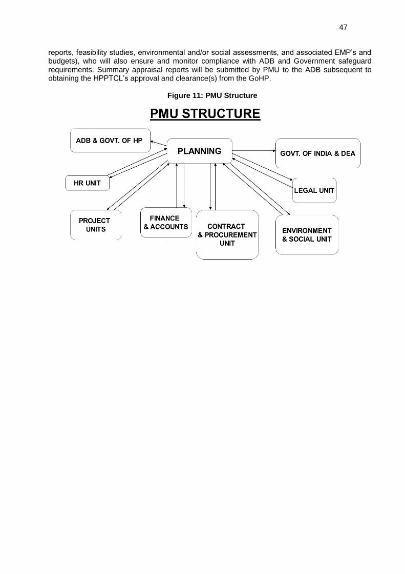
47
reports, feasibility studies, environmental and/or social assessments, and associated EMP’s and budgets), who will also ensure and monitor compliance with ADB and Government safeguard requirements. Summary appraisal reports will be submitted by PMU to the ADB subsequent to obtaining the HPPTCL’s approval and clearance(s) from the GoHP.
Figure 11: PMU Structure
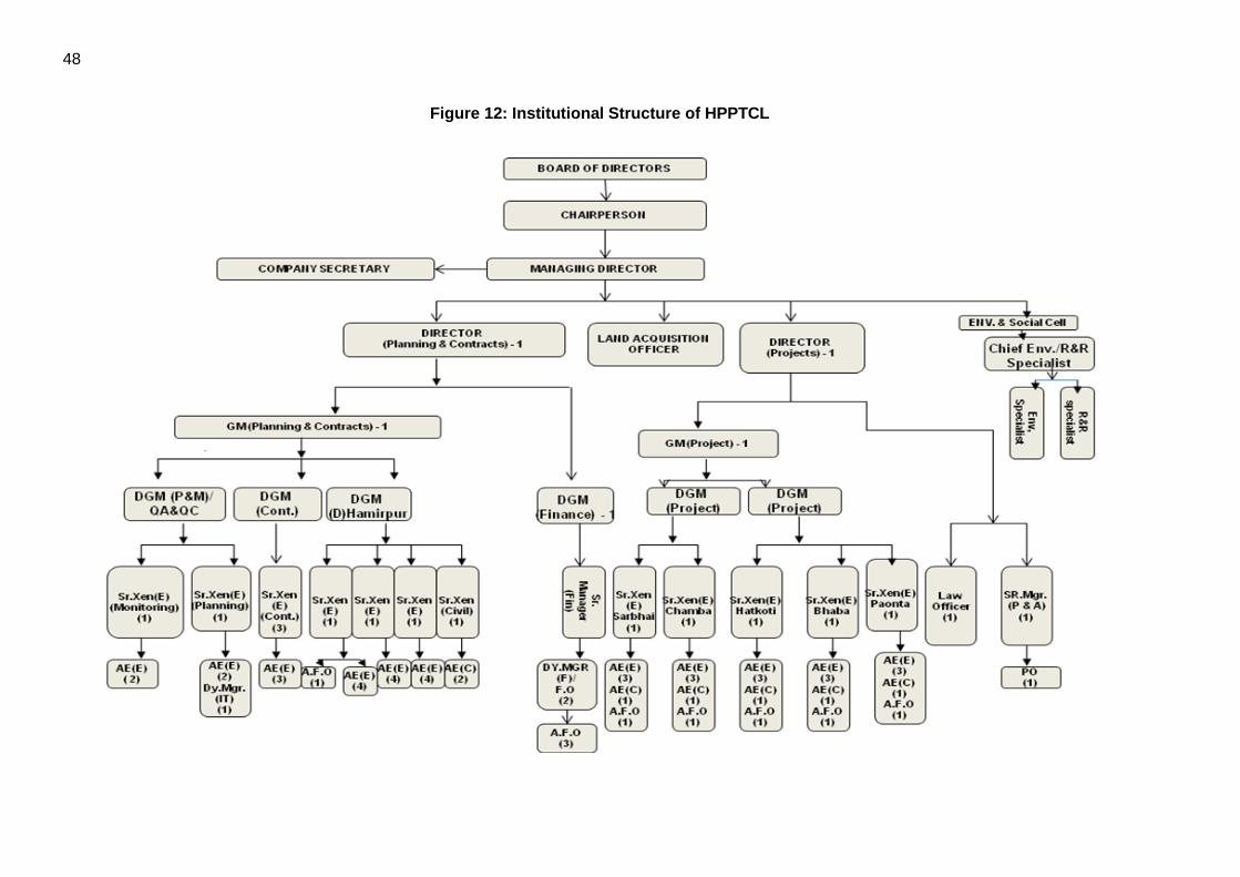
48
Figure 12: Institutional Structure of HPPTCL

49
5.1 Environmental Monitoring Plan 157. The mitigation measures suggested require monitoring of environmental parameters both during construction and operational phases of the project, the monitoring of the environmental aspects shall be done by the Chief Environment & RR Specialist of Environment and Social Cell (ESC) of HPPTCL. During the construction phase, the Contractor should ensure that activities like handling of earth works, disposal of debris, storage of materials, labour camps, putting proper traffic signals is done properly to have minimum impact. This in turn should be monitored by the Project Manager of the individual transmission line/substation project. 158. The Environmental and Social Cell will ensure that site engineers and contractors adhere and comply with all measures and procedures identified in the EMP. Activities to be monitored include: all planning, coordination and management activities related to the implementation of safeguard issues; the identification of corrective and preventive actions; records of health and safety matters and training activities; consultations with project affected people (as and when needed, particularly during the implementation); feedback, trouble shooting and project related grievances; preparation of progress and monitoring reports as required by the ADB; and verifying the projects overall compliance with safeguard measures and its progress towards achieving the intended loan outcomes.
159. Mitigation measures related to construction as specified in the EMP will be incorporated into civil works contracts, and their implementation will be primarily the responsibility of the contractors. In addition, contractors will be requested to submit monthly progress reports on the implementation of EMP measures to PIU/PMU. The PMU and the HPPTCL will report to the ADB on progress achieved against the EMP activities and milestones on a half-yearly basis. Progress reports will include a description of implementable activities and their status; identify the responsible parties involved in their implementation; and provide project management schedules and timeframes for doing so, along with their associated costs.
160. In addition to the EMP, to ensure that project would not generate negative impacts to the overall environment quality, an Environmental Monitoring Plan (EMoP) will be prepared. The monitoring activities of the project include site supervision, verification of permits, monitoring of water quality, soil, noise and air. Monitoring of the quality of water, soil, air and noise during the construction stage is a responsibility of the contractor by the approved government agency. The PIU will supervise the contractor. Other environmental good practices include sanitary waste management, noise abatement, maintaining hygienic conditions, maintenance of fire and safety equipment.
161. The Environment and social cell after interaction with Project managers of PIUs will prepare and submit performance monitoring reports to the ADB twice yearly. This report will include the results of environmental monitoring to demonstrate that sound environmental management practices are applied, and the set environments targets are achieved. The environmental monitoring plan for the Project is summarised in Annex 3. In case the implementation of EMP measures is not satisfactory, HPPTCL will engage external qualified experts to verify monitoring reports and assess the significant impacts and risks. These external monitoring experts will recommend actions for HPPTCL to enhance environmental compliance. ADB will continue to monitor project compliance with ADB safeguard plans and requirements on an on-going basis throughout the duration of the contract.
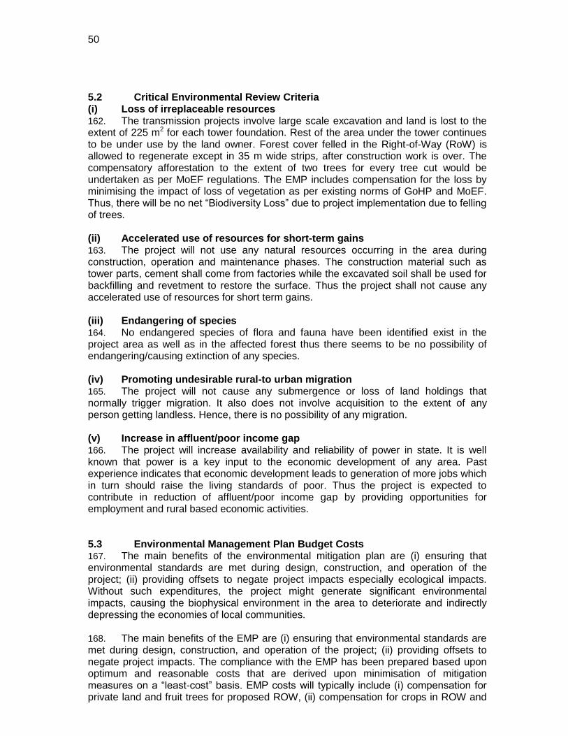
50
5.2 Critical Environmental Review Criteria (i) Loss of irreplaceable resources 162. The transmission projects involve large scale excavation and land is lost to the extent of 225 m2 for each tower foundation. Rest of the area under the tower continues to be under use by the land owner. Forest cover felled in the Right-of-Way (RoW) is allowed to regenerate except in 35 m wide strips, after construction work is over. The compensatory afforestation to the extent of two trees for every tree cut would be undertaken as per MoEF regulations. The EMP includes compensation for the loss by minimising the impact of loss of vegetation as per existing norms of GoHP and MoEF. Thus, there will be no net ―Biodiversity Loss‖ due to project implementation due to felling of trees. (ii) Accelerated use of resources for short-term gains 163. The project will not use any natural resources occurring in the area during construction, operation and maintenance phases. The construction material such as tower parts, cement shall come from factories while the excavated soil shall be used for backfilling and revetment to restore the surface. Thus the project shall not cause any accelerated use of resources for short term gains. (iii) Endangering of species 164. No endangered species of flora and fauna have been identified exist in the project area as well as in the affected forest thus there seems to be no possibility of endangering/causing extinction of any species. (iv) Promoting undesirable rural-to urban migration 165. The project will not cause any submergence or loss of land holdings that normally trigger migration. It also does not involve acquisition to the extent of any person getting landless. Hence, there is no possibility of any migration. (v) Increase in affluent/poor income gap 166. The project will increase availability and reliability of power in state. It is well known that power is a key input to the economic development of any area. Past experience indicates that economic development leads to generation of more jobs which in turn should raise the living standards of poor. Thus the project is expected to contribute in reduction of affluent/poor income gap by providing opportunities for employment and rural based economic activities. 5.3 Environmental Management Plan Budget Costs 167. The main benefits of the environmental mitigation plan are (i) ensuring that environmental standards are met during design, construction, and operation of the project; (ii) providing offsets to negate project impacts especially ecological impacts. Without such expenditures, the project might generate significant environmental impacts, causing the biophysical environment in the area to deteriorate and indirectly depressing the economies of local communities. 168. The main benefits of the EMP are (i) ensuring that environmental standards are met during design, construction, and operation of the project; (ii) providing offsets to negate project impacts. The compliance with the EMP has been prepared based upon optimum and reasonable costs that are derived upon minimisation of mitigation measures on a ―least-cost‖ basis. EMP costs will typically include (i) compensation for private land and fruit trees for proposed ROW, (ii) compensation for crops in ROW and
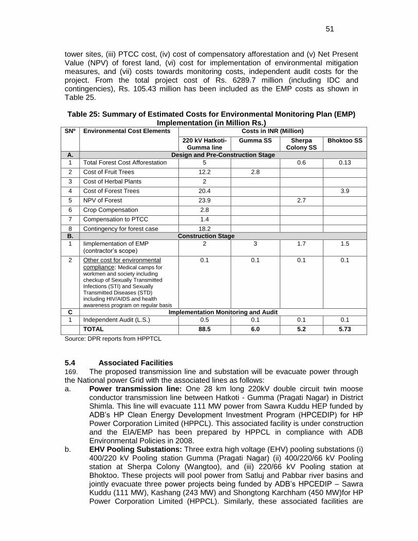
51
tower sites, (iii) PTCC cost, (iv) cost of compensatory afforestation and (v) Net Present Value (NPV) of forest land, (vi) cost for implementation of environmental mitigation measures, and (vii) costs towards monitoring costs, independent audit costs for the project. From the total project cost of Rs. 6289.7 million (including IDC and contingencies), Rs. 105.43 million has been included as the EMP costs as shown in Table 25.
Table 25: Summary of Estimated Costs for Environmental Monitoring Plan (EMP) Implementation (in Million Rs.)
SNº Environmental Cost Elements Costs in INR (Million)
220 kV Hatkoti-Gumma line
Gumma SS Sherpa Colony SS
Bhoktoo SS
A. Design and Pre-Construction Stage
1 Total Forest Cost Afforestation 5 0.6 0.13
2 Cost of Fruit Trees 12.2 2.8
3 Cost of Herbal Plants 2
4 Cost of Forest Trees 20.4 3.9
5 NPV of Forest 23.9 2.7
6 Crop Compensation 2.8
7 Compensation to PTCC 1.4
8 Contingency for forest case 18.2
B. Construction Stage
1 Iimplementation of EMP (contractor’s scope)
2 3 1.7 1.5
2 Other cost for environmental compliance: Medical camps for workmen and society including checkup of Sexually Transmitted Infections (STI) and Sexually Transmitted Diseases (STD) including HIV/AIDS and health awareness program on regular basis
0.1 0.1 0.1 0.1
C Implementation Monitoring and Audit
1 Independent Audit (L.S.) 0.5 0.1 0.1 0.1
TOTAL 88.5 6.0 5.2 5.73
Source: DPR reports from HPPTCL
5.4 Associated Facilities 169. The proposed transmission line and substation will be evacuate power through the National power Grid with the associated lines as follows: a. Power transmission line: One 28 km long 220kV double circuit twin moose
conductor transmission line between Hatkoti - Gumma (Pragati Nagar) in District Shimla. This line will evacuate 111 MW power from Sawra Kuddu HEP funded by ADB’s HP Clean Energy Development Investment Program (HPCEDIP) for HP Power Corporation Limited (HPPCL). This associated facility is under construction and the EIA/EMP has been prepared by HPPCL in compliance with ADB Environmental Policies in 2008.
b. EHV Pooling Substations: Three extra high voltage (EHV) pooling substations (i) 400/220 kV Pooling station Gumma (Pragati Nagar) (ii) 400/220/66 kV Pooling station at Sherpa Colony (Wangtoo), and (iii) 220/66 kV Pooling station at Bhoktoo. These projects will pool power from Satluj and Pabbar river basins and jointly evacuate three power projects being funded by ADB’s HPCEDIP – Sawra Kuddu (111 MW), Kashang (243 MW) and Shongtong Karchham (450 MW)for HP Power Corporation Limited (HPPCL). Similarly, these associated facilities are
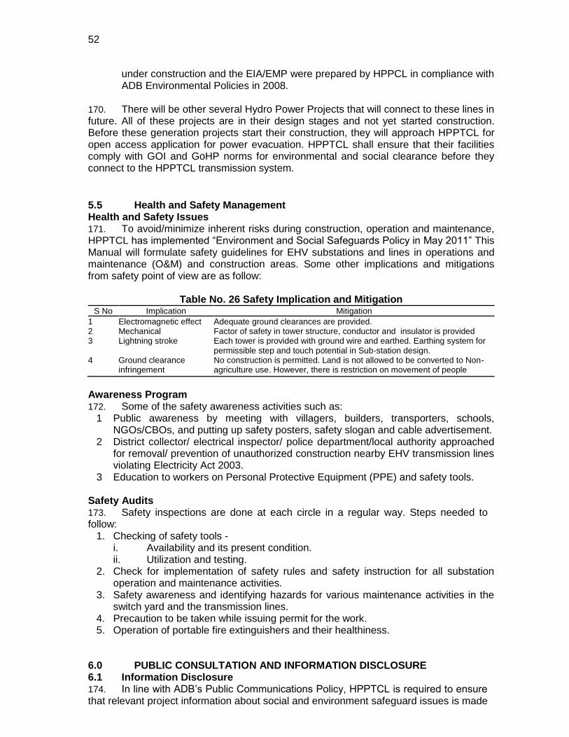
52
under construction and the EIA/EMP were prepared by HPPCL in compliance with ADB Environmental Policies in 2008.
170. There will be other several Hydro Power Projects that will connect to these lines in future. All of these projects are in their design stages and not yet started construction. Before these generation projects start their construction, they will approach HPPTCL for open access application for power evacuation. HPPTCL shall ensure that their facilities comply with GOI and GoHP norms for environmental and social clearance before they connect to the HPPTCL transmission system.
5.5 Health and Safety Management Health and Safety Issues 171. To avoid/minimize inherent risks during construction, operation and maintenance, HPPTCL has implemented ―Environment and Social Safeguards Policy in May 2011‖ This Manual will formulate safety guidelines for EHV substations and lines in operations and maintenance (O&M) and construction areas. Some other implications and mitigations from safety point of view are as follow:
Table No. 26 Safety Implication and Mitigation S No Implication Mitigation
1 Electromagnetic effect Adequate ground clearances are provided. 2 Mechanical Factor of safety in tower structure, conductor and insulator is provided 3 Lightning stroke Each tower is provided with ground wire and earthed. Earthing system for
permissible step and touch potential in Sub-station design. 4 Ground clearance
infringement No construction is permitted. Land is not allowed to be converted to Non-agriculture use. However, there is restriction on movement of people
Awareness Program 172. Some of the safety awareness activities such as:
1 Public awareness by meeting with villagers, builders, transporters, schools, NGOs/CBOs, and putting up safety posters, safety slogan and cable advertisement.
2 District collector/ electrical inspector/ police department/local authority approached for removal/ prevention of unauthorized construction nearby EHV transmission lines violating Electricity Act 2003.
3 Education to workers on Personal Protective Equipment (PPE) and safety tools.
Safety Audits 173. Safety inspections are done at each circle in a regular way. Steps needed to follow:
1. Checking of safety tools - i. Availability and its present condition. ii. Utilization and testing.
2. Check for implementation of safety rules and safety instruction for all substation operation and maintenance activities.
3. Safety awareness and identifying hazards for various maintenance activities in the switch yard and the transmission lines.
4. Precaution to be taken while issuing permit for the work. 5. Operation of portable fire extinguishers and their healthiness.
6.0 PUBLIC CONSULTATION AND INFORMATION DISCLOSURE 6.1 Information Disclosure 174. In line with ADB’s Public Communications Policy, HPPTCL is required to ensure that relevant project information about social and environment safeguard issues is made
53
available during the initial stages to affected people and other stakeholders, including the general public at district headquarters where it is publicly accessible in English, Hindi and any other vernacular local language. ADB and HPPTCL will also post these documents as well as the Environment Assessment and Review Framework Document (EARF) and the IEE on their respective websites. 175. Incorporation of the environmental concerns of APs through the public consultation in the decision making process will avoid or minimise conflict situations during the implementation process as well as enable them to provide meaningful inputs into the project design and its implementation. HPPTCL can conduct public consultation and information disclosure through public meetings and notice. 6.2 Public Consultation 176. During the project formulation stage, HPPTCL has conducted a project scoping exercise and reconnaissance survey of the existing system. Accordingly, during public consultation sessions, considerable dialogue had been held between HPPTCL representatives, individuals, and groups from the community to make them aware of the proposed project. 177. The project-affected community residing beside the proposed feeder lines has already gained a reasonable knowledge about the potential grievances, which may arise in the future. The community were also informed about the Grievance Redress Mechanism (GRM), which will be followed by HPPTCL as per procedure listed in its Environmental and Social Safeguards Policy (May 2011) for making complaints, including the place and the responsible person to contact in this regard. 6.3 Consultation Findings 178. Incorporation of environmental concerns of affected persons (APs) through the public consultation will help avoid or minimise conflict situations and enable them to provide meaningful inputs into the project design and implementation process. Consultations and group discussions are carried out along the project sites by the project safeguard consultants between February-mid-May 2011. The discussion was carried out in almost all the villages coming within 500m vicinity of the alignment of transmission line and at Gumma (Pragati Nagar) substation site in Shimla district. In Kinnaur district, public consultations were carried out in two nearest villages which were located approximately 7-10 km away from both sub-station sites. Attached Annex 5 lists detailed public consultations during the field survey by the team.
179. As part of the social assessment, approximately 100 households have been surveyed where the heads of the households were interviewed to collect the data during the month of February to mid-May 2011. Additionally, public consultations were carried out by the social survey team through focused group discussion along the project site. Additionally, the social and environment expert from the consultant team carried out various informal consultations during the site assessment with concerned village heads and local people at various villages. Tables A5.1-3 lists villages where the consultations were held in the Shimla and Kinnaur Districts. Summary of people’s perception of the project during the consultation is presented below
220 kV Hatkoti - Gumma line 180. The project area falls in Hatkoti, Sari, Astandli, Mandhol, Manghara, Kot, Magouta, Gahir, Sholi, Kaina Dogri, Santoshinagar, Rampuri, Jata di, Naktada, Deem, Jhalari, Kharapather, Darkoti, Chandal, Jandol, Halai, Soshan, Marathu, Pujarli, Kalala,
54
Gulara, Kutdhar, Darbar, Dalsar, Bakneol, Pandrog, Pudag, Khodudhar, Maghali and Bagori of Jubbal and Hatkoti tehsil of Shimla district. This area is a rich Apple producing belt of state, where people of area showed a mixed reaction to the project. Maximum people accepted the project as an income generating national interest project at same time some villagers were worried about the loosing potential agriculture land and fruiting apple crops. Some people raised issue of possible harms and accidental disaster of the transmission line and asked HPPTCL people to take maximum care during the operation phase and give training for mitigation of possible harms and accidental disasters caused by the project. Villagers were also showed their concern about land slide, soil erosion and dust generated during the construction activities and causing damage to the crop in nearby area and requested HPPTCL officials to avoid construction activities during flowering seasons. People of the area requested HPPTCL to give maximum employment and construction and labour works to the locals with first preference to project affected persons. On the whole. The people accepted the project by giving their assurance for supporting the project activities. Table A5.4 in Annex 5 lists participants for consultation at Shimla district for 220 kV Transmission Line. Gumma (Pragati Nagar) Substation 181. The land selected for construction of Gumma substation is about 5 km from any habitation. It is situated in Bagori village near Gumma (Pragati Nagar) town of Shimla district. Public consultation was carried out at Bagori village - the land belongs to a single owner who is interested in selling the land to Government for developmental woks. An engineering college is also coming up nearby, and people of Bagori showed a positive response for the subproject with assurance of full support to the project. Table A5.5 in Annex 5 lists participants for consultation in Shimla district for Gumma (Pragati Nagar) GIS pooling substation. Wangtoo (Sherpa colony) 182. The site selected for the Wangtoo substation is a grazing land of Panchayat, Katgaon which is also the nearest village is located approximately 14 km away from the selected site. Though people of village showed concern of losing the grazing land; but also showed positive response for the project as it help generate employment, jobs and labour and job opportunities in the area and will give chances of future development of the area. Table A5.6 in Annex 5 lists participants for consultation in Kinnaur district for Sherpa Colony (Wangtoo) pooling substation. Bhoktoo 183. The site selected for substation is a government forest land and the nearest habitation is Talangi village which is situated approximately 7 km away from the site. The villagers of Talangi village showed no concern about the project.
7.0 GRIEVANCE REDRESS MECHANISM 184. Through its Environment and Social Safeguards Policy5, HPPTCL has established a Grievance Redressal Mechanism (GRM) having suitable grievance redressal procedure for the project affected persons. The grievance redress mechanism would address affected persons’ concerns and complaints promptly, using an understandable and transparent process that is gender responsive, culturally appropriate, and readily accessible to the affected persons at no costs and without retribution. This GRM consists of a Grievance Redressal Committee consists of the following persons as listed in Table 27 below:
5 Finalized in May 2011
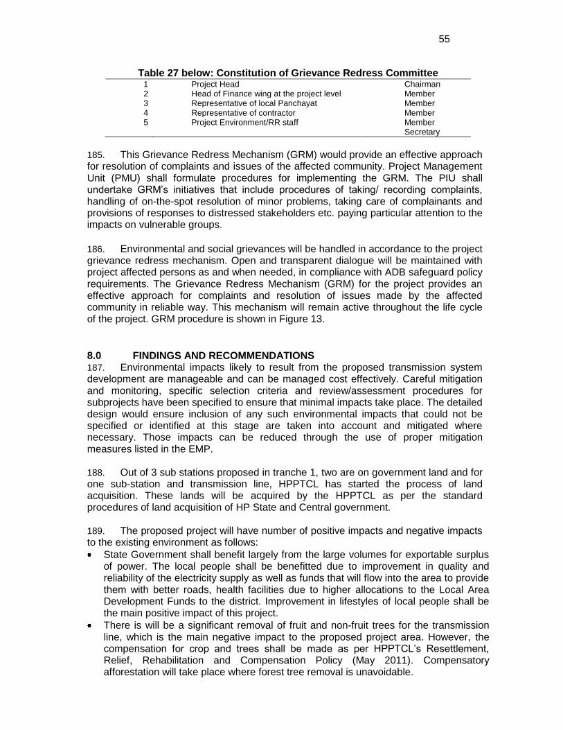
55
Table 27 below: Constitution of Grievance Redress Committee 1 Project Head Chairman 2 Head of Finance wing at the project level Member 3 Representative of local Panchayat Member 4 Representative of contractor Member 5 Project Environment/RR staff Member
Secretary
185. This Grievance Redress Mechanism (GRM) would provide an effective approach for resolution of complaints and issues of the affected community. Project Management Unit (PMU) shall formulate procedures for implementing the GRM. The PIU shall undertake GRM’s initiatives that include procedures of taking/ recording complaints, handling of on-the-spot resolution of minor problems, taking care of complainants and provisions of responses to distressed stakeholders etc. paying particular attention to the impacts on vulnerable groups.
186. Environmental and social grievances will be handled in accordance to the project grievance redress mechanism. Open and transparent dialogue will be maintained with project affected persons as and when needed, in compliance with ADB safeguard policy requirements. The Grievance Redress Mechanism (GRM) for the project provides an effective approach for complaints and resolution of issues made by the affected community in reliable way. This mechanism will remain active throughout the life cycle of the project. GRM procedure is shown in Figure 13.
8.0 FINDINGS AND RECOMMENDATIONS 187. Environmental impacts likely to result from the proposed transmission system development are manageable and can be managed cost effectively. Careful mitigation and monitoring, specific selection criteria and review/assessment procedures for subprojects have been specified to ensure that minimal impacts take place. The detailed design would ensure inclusion of any such environmental impacts that could not be specified or identified at this stage are taken into account and mitigated where necessary. Those impacts can be reduced through the use of proper mitigation measures listed in the EMP. 188. Out of 3 sub stations proposed in tranche 1, two are on government land and for one sub-station and transmission line, HPPTCL has started the process of land acquisition. These lands will be acquired by the HPPTCL as per the standard procedures of land acquisition of HP State and Central government. 189. The proposed project will have number of positive impacts and negative impacts to the existing environment as follows:
State Government shall benefit largely from the large volumes for exportable surplus of power. The local people shall be benefitted due to improvement in quality and reliability of the electricity supply as well as funds that will flow into the area to provide them with better roads, health facilities due to higher allocations to the Local Area Development Funds to the district. Improvement in lifestyles of local people shall be the main positive impact of this project.
There is will be a significant removal of fruit and non-fruit trees for the transmission line, which is the main negative impact to the proposed project area. However, the compensation for crop and trees shall be made as per HPPTCL’s Resettlement, Relief, Rehabilitation and Compensation Policy (May 2011). Compensatory afforestation will take place where forest tree removal is unavoidable.
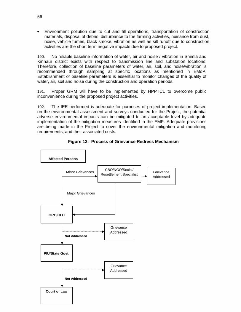
56
Environment pollution due to cut and fill operations, transportation of construction materials, disposal of debris, disturbance to the farming activities, nuisance from dust, noise, vehicle fumes, black smoke, vibration as well as silt runoff due to construction activities are the short term negative impacts due to proposed project.
190. No reliable baseline information of water, air and noise / vibration in Shimla and Kinnaur district exists with respect to transmission line and substation locations. Therefore, collection of baseline parameters of water, air, soil, and noise/vibration is recommended through sampling at specific locations as mentioned in EMoP. Establishment of baseline parameters is essential to monitor changes of the quality of water, air, soil and noise during the construction and operation periods. 191. Proper GRM will have to be implemented by HPPTCL to overcome public inconvenience during the proposed project activities.
192. The IEE performed is adequate for purposes of project implementation. Based on the environmental assessment and surveys conducted for the Project, the potential adverse environmental impacts can be mitigated to an acceptable level by adequate implementation of the mitigation measures identified in the EMP. Adequate provisions are being made in the Project to cover the environmental mitigation and monitoring requirements, and their associated costs.
Figure 13: Process of Grievance Redress Mechanism
Affected Persons
PIU/State Govt.
Grievance
Addressed
GRC/CLC
Grievance
Addressed
Court of Law
Minor Grievances
Major Grievances
Not Addressed
Grievance
Addressed
Not Addressed
CBO/NGO/Social/
Resettlement Specialist
57
9.0 CONCLUSIONS 193. An environment and social analysis has been carried out looking at various criteria such as topology, air, noise, water resources and water quality, ecology, demography of the area, climate and natural habitat, community and employee health and safety etc. The impact analysis, found that due to careful consideration of environmental and social aspects during route and site selection by HPPTCL, no major adverse impacts are expected. There is no adverse impact on the migration of habitat, any natural existing land resources and effect in the regular life of people. The environment and social impact associated with transmission line project is limited to the extent of construction phase and can be mitigated through a set of recommended measures and adequate provision for environment and social impacts which cover monitoring, measuring and mitigation. 194. EMP has been prepared. Public consultations have been conducted along the transmission corridor. The results indicate broad support for the project based on perceived economic and social benefits. Most impacts are expected to occur during the construction phase and are considered to be of a temporary nature. The transmission corridor was carefully selected after undergoing an options assessment. This enabled the right of way alignment to bypass nearby reserve forest area, villages and important water supplies and resources. The main project impacts are associated with cutting of orchards, waste management and excavation of soils. 195. No endangered or protected species of flora or fauna are reported at any of the subproject sites. The substation sites are located mostly on land owned by GOHP, characterized as mostly barren, uninhabited and unused lands, removed from populated areas. Adequate provisions have been made for the environmental mitigation and monitoring of predicted impacts, along with their associated costs. Adverse impacts if noticed during implementation will be mitigated using appropriate design and management measures. The potential cumulative and residual impacts of the transmission sub-components as a whole indicate the project classifies as a category ―B‖, in accordance with ADB’s Safeguards Policy Statement 2009. The Project is not considered highly sensitive or complex. 196. Based on the MoEF Guidelines of GoI and the ADB Safeguard 2009 guidelines, the proposed project was categorised as ―B‖. Thus, an IEE report has been prepared for the project. Thus a full Environmental Impact Assessments (EIA) for the Project is not required. Mitigation measures related to construction, as specified in the EMP, will be incorporated into civil works contracts, and their implementation will be primarily the responsibility of the contractors. The EA/IA (HPPTCL) will however be responsible for the overall implementation and auditing of site-specific EMPs.
58
Annex 1 Applicable Rules, Regulation, Policies and Procedures
A. National Environmental Laws 1. The Environmental regulations, legislation, policy guidelines that may impact this project, are the responsibility of a variety of government agencies. The principal Environment Regulatory Agency in India is the Ministry of Environment and Forests (MoEF). MoEF formulates environmental policies and accords environmental clearances for different projects. 2. The Important environmental legislations in India are given below (i) The Water (Prevention and Control of Pollution) Act, 1974, amended 1988 (ii) The Water (Prevention and Control of Pollution) Rules, 1975 (iii) The Air (Prevention and Control of Pollution) Act 1981, amended 1987 (iv) The Air (Prevention and Control of Pollution) Rules, 1982 (v) The Environment (Protection) Act, 1986, amended 1991 and including the following
Rules/Notification issued under this Act.
The Environment (Protection) Rules, 1986, including amendments
The Municipal Solid Wastes (Management and Handling) Rules, 2000
The Hazardous Wastes (Management and Handling) Rules, 2003
The Hazardous Wastes (management, handling and transboundary movement) Rules 2009
The Bio-Medical Waste (Management and Handling) Rules, 1998
Noise Pollution (Regulation and Control) Rules, 2000,
Wild Life (Protection) Amendment Act, 2002
Ozone Depleting Substances (Regulation & Control) Rules, 2000.
The Biological Diversity Act, 2002;
The Environment Impact Assessment Notification, 1994; amended up to 2009;
Batteries (Management & Handling) Rules, 2001
The Environmental Clearance Notification, 1994
Environmental Standards of CPCB (vi) Noise Pollution (Regulation and Control) Rules, 2000 (vii) The Indian Wildlife (Protection) Act, 1972, amended 1993 (viii) The Wildlife (Protection) Rules, 1995 (ix) The Indian Forest Act, 1927 (x) Forest (Conservation) Act, 1980, amended 1988 (National Forest Policy, 1988)
Forest (Conservation) Rules, 1981 amended 1992 and 2003
Guidelines for diversion of forest lands for non-forest purpose under the Forest (Conservation) Act, 1980
(xi) The National Environmental Appellate Authority Act, 1997 (xii) The National Green Tribunal Act, 2010 B. State Government Policies 18. Some of the Himachal Pradesh Government and HPPTCL’s policies that are applicable to the sub-projects are:
The Himachal Pradesh Hydropower Policy 2007;
Himachal Pradesh Land Preservation Act (LPA);
HPPTCL Environment and Social Safeguards Policy, May 2011; and
Resettlement, Relief, Rehabilitation and Compensation Policy, May 2011. C. Other Acts The policy framework consists of following main regulations:
1. The Electricity Act, 2003 2. National Resettlement & Rehabilitation Policy, 2007 (NRRP) (MoRD, DoLR). 3. Right of Way and compensation under Electricity Laws. 4. Land Acquisition Act, 1894.
5. The Indian Telegraph Act (ITA), 1885
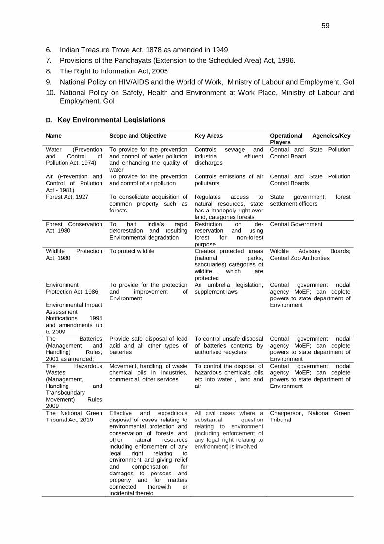
59
6. Indian Treasure Trove Act, 1878 as amended in 1949
7. Provisions of the Panchayats (Extension to the Scheduled Area) Act, 1996.
8. The Right to Information Act, 2005
9. National Policy on HIV/AIDS and the World of Work, Ministry of Labour and Employment, GoI
10. National Policy on Safety, Health and Environment at Work Place, Ministry of Labour and Employment, GoI
D. Key Environmental Legislations
Name Scope and Objective Key Areas Operational Agencies/Key
Players
Water (Prevention and Control of Pollution Act, 1974)
To provide for the prevention and control of water pollution and enhancing the quality of water
Controls sewage and industrial effluent discharges
Central and State Pollution Control Board
Air (Prevention and Control of Pollution Act - 1981)
To provide for the prevention and control of air pollution
Controls emissions of air pollutants
Central and State Pollution Control Boards
Forest Act, 1927 To consolidate acquisition of common property such as forests
Regulates access to natural resources, state has a monopoly right over land, categories forests
State government, forest settlement officers
Forest Conservation Act, 1980
To halt India’s rapid deforestation and resulting Environmental degradation
Restriction on de-reservation and using forest for non-forest purpose
Central Government
Wildlife Protection Act, 1980
To protect wildlife Creates protected areas (national parks, sanctuaries) categories of wildlife which are protected
Wildlife Advisory Boards; Central Zoo Authorities
Environment Protection Act, 1986 Environmental Impact Assessment Notifications 1994 and amendments up to 2009
To provide for the protection and improvement of Environment
An umbrella legislation; supplement laws
Central government nodal agency MoEF; can deplete powers to state department of Environment
The Batteries (Management and Handling) Rules, 2001 as amended;
Provide safe disposal of lead acid and all other types of batteries
To control unsafe disposal of batteries contents by authorised recyclers
Central government nodal agency MoEF; can deplete powers to state department of Environment
The Hazardous Wastes (Management, Handling and Transboundary Movement) Rules 2009
Movement, handling, of waste chemical oils in industries, commercial, other services
To control the disposal of hazardous chemicals, oils etc into water , land and air
Central government nodal agency MoEF; can deplete powers to state department of Environment
The National Green Tribunal Act, 2010
Effective and expeditious disposal of cases relating to environmental protection and conservation of forests and other natural resources including enforcement of any legal right relating to environment and giving relief and compensation for damages to persons and property and for matters connected therewith or incidental thereto
All civil cases where a substantial question relating to environment (including enforcement of any legal right relating to environment) is involved
Chairperson, National Green Tribunal
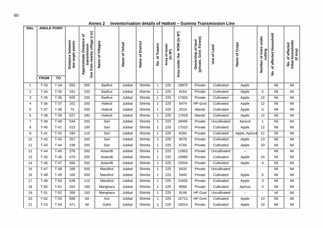
60
Annex 2 Inventorisation details of Hatkoti – Gumma Transmission Line SNo. ANGLE POINT
Dis
tan
ce b
etw
ee
n
two
an
gle
po
ints
Ap
pro
xim
ate
Dis
tan
ce
of
tran
sm
iss
ion
lin
e f
rom
ne
arb
y v
illa
ge
(i m
)
Nam
e o
f V
illa
ges
Nam
e o
f T
eh
sil
Nam
e o
f D
istr
ict
No
. o
f T
ow
ers
Are
a o
f to
we
r
(in
M²)
Are
a u
nd
er
the
R
OW
(in
M²)
Ow
ne
rsh
ip o
f la
nd
(pri
va
te,
Go
vt.
Fo
res
t)
Use
of
Lan
d
Nam
e o
f C
rop
s
Nu
mb
er
of
tree
s u
nd
er
cu
ttin
g
No
. o
f a
ffec
ted
Ho
us
eh
old
No
. o
f a
ffac
ted
trib
al
ho
us
eh
old
s
(if
An
y)
FROM TO
1 T-33 T-34 555 250 Badhot Jubbal Shimla 1 225 18870 Private Cultivated Apple Nil Nil
2 T-34 T-35 181 150 Badhot Jubbal Shimla 1 225 6154 Private Cultivated Apple 5 Nil Nil
3 T-35 T-36 500 200 Badhot Jubbal Shimla 1 225 17000 Private Cultivated Apple 10 Nil Nil
4 T-36 T-37 161 250 Hatkoti Jubbal Shimla 1 225 5474 HP Govt Cultivated Apple 12 Nil Nil
5 T-37 T-38 74 250 Hatkoti Jubbal Shimla 1 225 2516 Mandir Cultivated Apple 6 Nil Nil
6 T-38 T-39 527 280 Hatkoti Jubbal Shimla 1 225 17918 Mandir Cultivated Apple 12 Nil Nil
7 T-39 T-40 544 200 Sari Jubbal Shimla 1 225 18496 Private Uncultivated Apricot 1 Nil Nil
8 T-40 T-41 515 100 Sari Jubbal Shimla 1 225 17510 Private Cultivated Apple 12 Nil Nil
9 T-41 T-42 184 110 Sari Jubbal Shimla 1 225 6256 Private Cultivated Apple, Apricot 12 Nil Nil
10 T-42 T-43 267 200 Sari Jubbal Shimla 1 225 9078 Private Cultivated Apple 13 Nil Nil
11 T-43 T-44 199 200 Sari Jubbal Shimla 1 225 6766 Private Cultivated Apple 20 Nil Nil
12 T-44 T-45 378 300 Astandli Jubbal Shimla 1 225 12852 Private Uncultivated -- Nil Nil
13 T-45 T-46 470 200 Astandli Jubbal Shimla 1 225 15980 Private Cultivated Apple 24 Nil Nil
14 T-46 T-47 456 250 Astandli Jubbal Shimla 1 225 15504 Private Cultivated Apple 4 Nil Nil
15 T-47 T-48 189 500 Mandhol Jubbal Shimla 1 225 6426 Private Uncultivated Nil Nil
16 T-48 T-49 160 500 Mandhol Jubbal Shimla 1 225 5440 Private Cultivated Apple 5 Nil Nil
17 T-49 T-50 638 110 Mandhol Jubbal Shimla 1 225 21692 Private Cultivated Apple 3 Nil Nil
18 T-50 T-51 252 150 Manghara Jubbal Shimla 1 225 8568 Private Cultivated Apricot 4 Nil Nil
19 T-51 T-52 269 150 Manghara Jubbal Shimla 1 225 9146 HP Govt Uncultivated -- - nil Nil
20 T-52 T-53 668 50 Kot Jubbal Shimla 1 225 22712 HP Govt Cultivated Apple 13 Nil Nil
21 T-53 T-54 471 40 Gahir Jubbal Shimla 1 225 16014 Private Cultivated Apple 10 Nil Nil
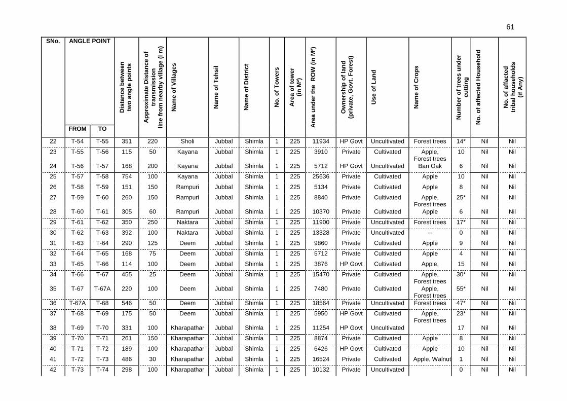
61
SNo. ANGLE POINT
Dis
tan
ce b
etw
ee
n
two
an
gle
po
ints
Ap
pro
xim
ate
Dis
tan
ce
of
tran
sm
iss
ion
lin
e f
rom
ne
arb
y v
illa
ge
(i m
)
Nam
e o
f V
illa
ges
Nam
e o
f T
eh
sil
Nam
e o
f D
istr
ict
No
. o
f T
ow
ers
Are
a o
f to
we
r
(in
M²)
Are
a u
nd
er
the
R
OW
(in
M²)
Ow
ne
rsh
ip o
f la
nd
(pri
va
te,
Go
vt.
Fo
res
t)
Use
of
Lan
d
Nam
e o
f C
rop
s
Nu
mb
er
of
tree
s u
nd
er
cu
ttin
g
No
. o
f a
ffec
ted
Ho
us
eh
old
No
. o
f a
ffac
ted
trib
al
ho
us
eh
old
s
(if
An
y)
FROM TO
22 T-54 T-55 351 220 Sholi Jubbal Shimla 1 225 11934 HP Govt Uncultivated Forest trees 14* Nil Nil
23 T-55 T-56 115 50 Kayana Jubbal Shimla 1 225 3910 Private Cultivated Apple, Forest trees
10 Nil Nil
24 T-56 T-57 168 200 Kayana Jubbal Shimla 1 225 5712 HP Govt Uncultivated Ban Oak 6 Nil Nil
25 T-57 T-58 754 100 Kayana Jubbal Shimla 1 225 25636 Private Cultivated Apple 10 Nil Nil
26 T-58 T-59 151 150 Rampuri Jubbal Shimla 1 225 5134 Private Cultivated Apple 8 Nil Nil
27 T-59 T-60 260 150 Rampuri Jubbal Shimla 1 225 8840 Private Cultivated Apple, Forest trees
25* Nil Nil
28 T-60 T-61 305 60 Rampuri Jubbal Shimla 1 225 10370 Private Cultivated Apple 6 Nil Nil
29 T-61 T-62 350 250 Naktara Jubbal Shimla 1 225 11900 Private Uncultivated Forest trees 17* Nil Nil
30 T-62 T-63 392 100 Naktara Jubbal Shimla 1 225 13328 Private Uncultivated -- 0 Nil Nil
31 T-63 T-64 290 125 Deem Jubbal Shimla 1 225 9860 Private Cultivated Apple 9 Nil Nil
32 T-64 T-65 168 75 Deem Jubbal Shimla 1 225 5712 Private Cultivated Apple 4 Nil Nil
33 T-65 T-66 114 100 Deem Jubbal Shimla 1 225 3876 HP Govt Cultivated Apple, 15 Nil Nil
34 T-66 T-67 455 25 Deem Jubbal Shimla 1 225 15470 Private Cultivated Apple, Forest trees
30* Nil Nil
35 T-67 T-67A 220 100 Deem Jubbal Shimla 1 225 7480 Private Cultivated Apple, Forest trees
55* Nil Nil
36 T-67A T-68 546 50 Deem Jubbal Shimla 1 225 18564 Private Uncultivated Forest trees 47* Nil Nil
37 T-68 T-69 175 50 Deem Jubbal Shimla 1 225 5950 HP Govt Cultivated Apple, Forest trees
23* Nil Nil
38 T-69 T-70 331 100 Kharapathar Jubbal Shimla 1 225 11254 HP Govt Uncultivated 17 Nil Nil
39 T-70 T-71 261 150 Kharapathar Jubbal Shimla 1 225 8874 Private Cultivated Apple 8 Nil Nil
40 T-71 T-72 189 100 Kharapathar Jubbal Shimla 1 225 6426 HP Govt Cultivated Apple 10 Nil Nil
41 T-72 T-73 486 30 Kharapathar Jubbal Shimla 1 225 16524 Private Cultivated Apple, Walnut 1 Nil Nil
42 T-73 T-74 298 100 Kharapathar Jubbal Shimla 1 225 10132 Private Uncultivated 0 Nil Nil
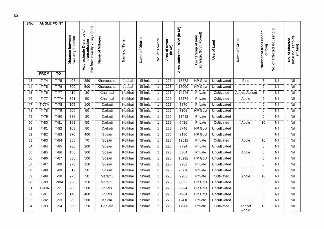
62
SNo. ANGLE POINT
Dis
tan
ce b
etw
ee
n
two
an
gle
po
ints
Ap
pro
xim
ate
Dis
tan
ce
of
tran
sm
iss
ion
lin
e f
rom
ne
arb
y v
illa
ge
(i m
)
Nam
e o
f V
illa
ges
Nam
e o
f T
eh
sil
Nam
e o
f D
istr
ict
No
. o
f T
ow
ers
Are
a o
f to
we
r
(in
M²)
Are
a u
nd
er
the
R
OW
(in
M²)
Ow
ne
rsh
ip o
f la
nd
(pri
va
te,
Go
vt.
Fo
res
t)
Use
of
Lan
d
Nam
e o
f C
rop
s
Nu
mb
er
of
tree
s u
nd
er
cu
ttin
g
No
. o
f a
ffec
ted
Ho
us
eh
old
No
. o
f a
ffac
ted
trib
al
ho
us
eh
old
s
(if
An
y)
FROM TO
43 T-74 T-75 408 250 Kharapathar Jubbal Shimla 1 225 13872 HP Govt Uncultivated Pine 3 Nil Nil
44 T-75 T-76 500 500 Kharapathar Jubbal Shimla 1 225 17000 HP Govt Uncultivated 0 Nil Nil
45 T-76 T-77 419 30 Chaindal Kotkhai Shimla 1 225 14246 Private Cultivated Apple, Apricot 7 Nil Nil
46 T-77 T-77A 361 50 Chaindal Kotkhai Shimla 1 225 12274 Private Cultivated Apple 6 Nil Nil
47 T-77A T-78 105 100 Darkoti Kotkhai Shimla 1 225 3570 Private Uncultivated 0 Nil Nil
48 T-78 T-79 209 50 Darkoti Kotkhai Shimla 1 225 7106 HP Govt Uncultivated 0 Nil Nil
49 T-79 T-80 338 20 Darkoti Kotkhai Shimla 1 225 11492 Private Uncultivated 0 Nil Nil
50 T-80 T-81 189 50 Darkoti Kotkhai Shimla 1 225 6426 Private Cultivated Apple 10 Nil Nil
51 T-81 T-82 169 50 Darkoti Kotkhai Shimla 1 225 5746 HP Govt Uncultivated Nil Nil
52 T-82 T-83 270 400 Sosan Kotkhai Shimla 1 225 9180 HP Govt Uncultivated Nil Nil
53 T-83 T-84 368 70 Sosan Kotkhai Shimla 1 225 12512 Private Cultivated Apple 10 Nil Nil
54 T-84 T-85 286 200 Sosan Kotkhai Shimla 1 225 9724 Private Uncultivated 0 Nil Nil
55 T-85 T-86 156 300 Sosan Kotkhai Shimla 1 225 5304 Private Uncultivated Apple 0 Nil Nil
56 T-86 T-87 538 500 Sosan Kotkhai Shimla 1 225 18292 HP Govt Uncultivated 0 Nil Nil
57 T-87 T-88 273 150 Sosan Kotkhai Shimla 1 225 9282 Private Uncultivated 0 Nil Nil
58 T-88 T-89 617 50 Sosan Kotkhai Shimla 1 225 20978 Private Uncultivated 0 Nil Nil
59 T-89 T-90 273 30 Marathu Kotkhai Shimla 1 225 9282 Private Cultivated Apple 10 Nil Nil
60 T-90 T-90A 238 150 Marathu Kotkhai Shimla 1 225 8092 HP Govt Uncultivated 0 Nil Nil
61 T-90A T-91 286 500 Pujarli Kotkhai Shimla 1 225 9724 HP Govt Uncultivated 0 Nil Nil
62 T-91 T-92 146 400 Pujarli Kotkhai Shimla 1 225 4964 HP Govt Uncultivated 0 Nil Nil
63 T-92 T-93 365 300 Kalala Kotkhai Shimla 1 225 12410 Private Uncultivated 0 Nil Nil
64 T-93 T-94 529 250 Ghalera Kotkhai Shimla 1 225 17986 Private Cultivated Apricot Apple
13 Nil Nil
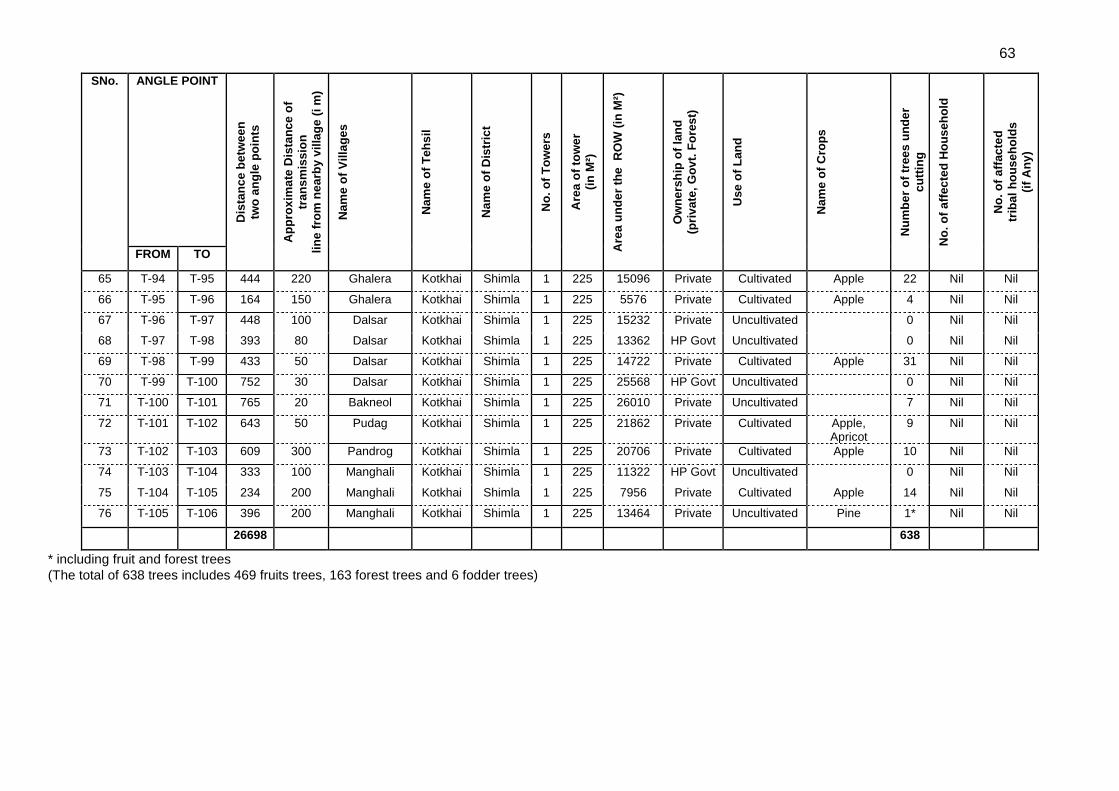
63
SNo. ANGLE POINT
Dis
tan
ce b
etw
ee
n
two
an
gle
po
ints
Ap
pro
xim
ate
Dis
tan
ce
of
tran
sm
iss
ion
lin
e f
rom
ne
arb
y v
illa
ge
(i m
)
Nam
e o
f V
illa
ges
Nam
e o
f T
eh
sil
Nam
e o
f D
istr
ict
No
. o
f T
ow
ers
Are
a o
f to
we
r
(in
M²)
Are
a u
nd
er
the
R
OW
(in
M²)
Ow
ne
rsh
ip o
f la
nd
(pri
va
te,
Go
vt.
Fo
res
t)
Use
of
Lan
d
Nam
e o
f C
rop
s
Nu
mb
er
of
tree
s u
nd
er
cu
ttin
g
No
. o
f a
ffec
ted
Ho
us
eh
old
No
. o
f a
ffac
ted
trib
al
ho
us
eh
old
s
(if
An
y)
FROM TO
65 T-94 T-95 444 220 Ghalera Kotkhai Shimla 1 225 15096 Private Cultivated Apple 22 Nil Nil
66 T-95 T-96 164 150 Ghalera Kotkhai Shimla 1 225 5576 Private Cultivated Apple 4 Nil Nil
67 T-96 T-97 448 100 Dalsar Kotkhai Shimla 1 225 15232 Private Uncultivated 0 Nil Nil
68 T-97 T-98 393 80 Dalsar Kotkhai Shimla 1 225 13362 HP Govt Uncultivated 0 Nil Nil
69 T-98 T-99 433 50 Dalsar Kotkhai Shimla 1 225 14722 Private Cultivated Apple 31 Nil Nil
70 T-99 T-100 752 30 Dalsar Kotkhai Shimla 1 225 25568 HP Govt Uncultivated 0 Nil Nil
71 T-100 T-101 765 20 Bakneol Kotkhai Shimla 1 225 26010 Private Uncultivated 7 Nil Nil
72 T-101 T-102 643 50 Pudag Kotkhai Shimla 1 225 21862 Private Cultivated Apple, Apricot
9 Nil Nil
73 T-102 T-103 609 300 Pandrog Kotkhai Shimla 1 225 20706 Private Cultivated Apple 10 Nil Nil
74 T-103 T-104 333 100 Manghali Kotkhai Shimla 1 225 11322 HP Govt Uncultivated 0 Nil Nil
75 T-104 T-105 234 200 Manghali Kotkhai Shimla 1 225 7956 Private Cultivated Apple 14 Nil Nil
76 T-105 T-106 396 200 Manghali Kotkhai Shimla 1 225 13464 Private Uncultivated Pine 1* Nil Nil
26698 638
* including fruit and forest trees
(The total of 638 trees includes 469 fruits trees, 163 forest trees and 6 fodder trees)
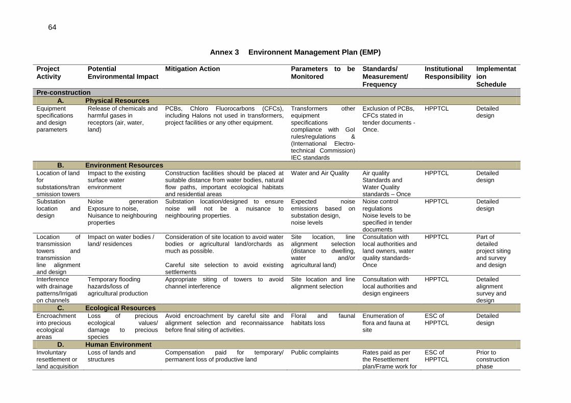
64
Annex 3 Environnent Management Plan (EMP)
Project Activity
Potential Environmental Impact
Mitigation Action Parameters to be Monitored
Standards/ Measurement/ Frequency
Institutional Responsibility
Implementation Schedule
Pre-construction
A. Physical Resources Equipment specifications and design parameters
Release of chemicals and harmful gases in receptors (air, water, land)
PCBs, Chloro Fluorocarbons (CFCs), including Halons not used in transformers, project facilities or any other equipment.
Transformers other equipment specifications compliance with GoI rules/regulations & (International Electro-technical Commission) IEC standards
Exclusion of PCBs, CFCs stated in tender documents - Once.
HPPTCL Detailed design
B. Environment Resources Location of land for substations/transmission towers
Impact to the existing surface water environment
Construction facilities should be placed at suitable distance from water bodies, natural flow paths, important ecological habitats and residential areas
Water and Air Quality Air quality Standards and Water Quality standards – Once
HPPTCL
Detailed design
Substation location and design
Noise generation Exposure to noise, Nuisance to neighbouring properties
Substation location/designed to ensure noise will not be a nuisance to neighbouring properties.
Expected noise emissions based on substation design, noise levels
Noise control regulations Noise levels to be specified in tender documents
HPPTCL Detailed design
Location of transmission towers and transmission line alignment and design
Impact on water bodies / land/ residences
Consideration of site location to avoid water bodies or agricultural land/orchards as much as possible. Careful site selection to avoid existing settlements
Site location, line alignment selection (distance to dwelling, water and/or agricultural land)
Consultation with local authorities and land owners, water quality standards-Once
HPPTCL Part of detailed project siting and survey and design
Interference with drainage patterns/Irrigation channels
Temporary flooding hazards/loss of agricultural production
Appropriate siting of towers to avoid channel interference
Site location and line alignment selection
Consultation with local authorities and design engineers
HPPTCL Detailed alignment survey and design
C. Ecological Resources Encroachment into precious ecological areas
Loss of precious ecological values/ damage to precious species
Avoid encroachment by careful site and alignment selection and reconnaissance before final siting of activities.
Floral and faunal habitats loss
Enumeration of flora and fauna at site
ESC of HPPTCL
Detailed design
D. Human Environment Involuntary resettlement or land acquisition
Loss of lands and structures
Compensation paid for temporary/ permanent loss of productive land
Public complaints Rates paid as per the Resettlement plan/Frame work for
ESC of HPPTCL
Prior to construction phase
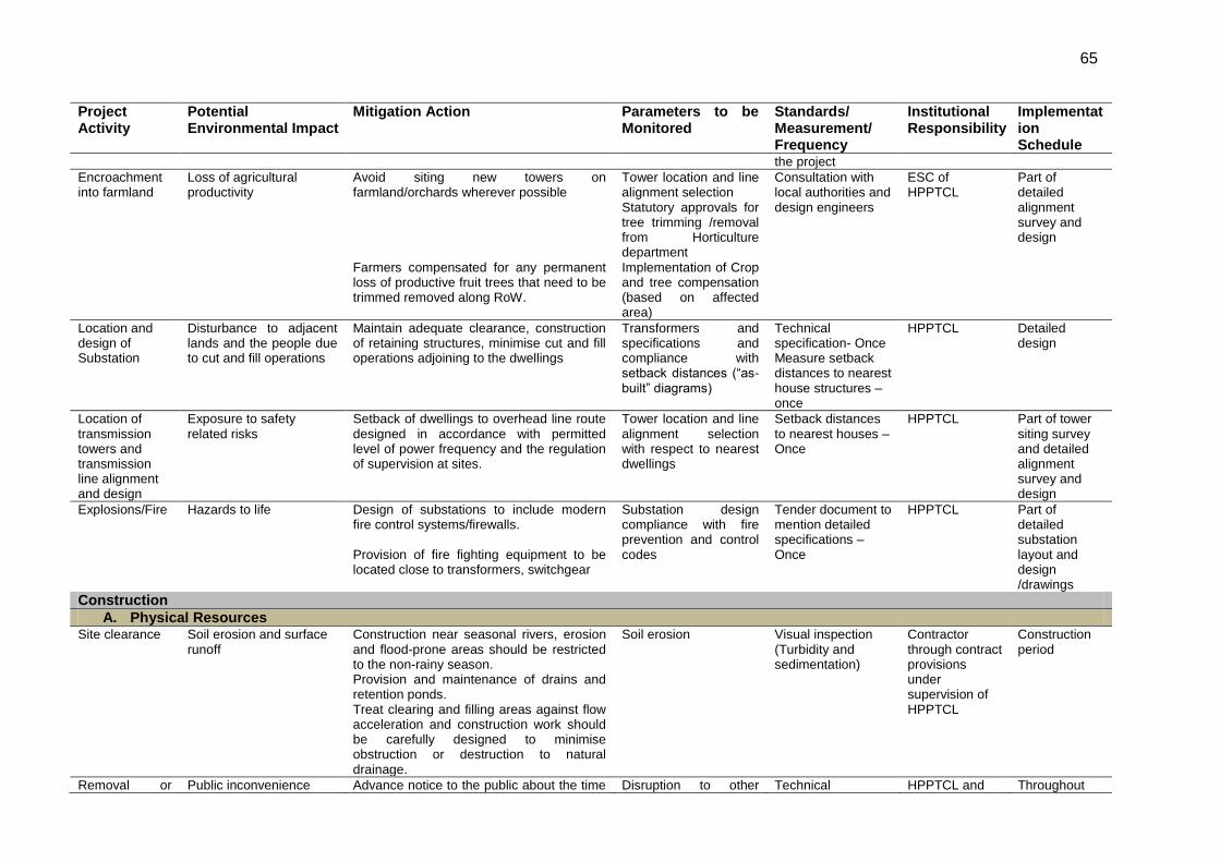
65
Project Activity
Potential Environmental Impact
Mitigation Action Parameters to be Monitored
Standards/ Measurement/ Frequency
Institutional Responsibility
Implementation Schedule
the project
Encroachment into farmland
Loss of agricultural productivity
Avoid siting new towers on farmland/orchards wherever possible Farmers compensated for any permanent loss of productive fruit trees that need to be trimmed removed along RoW.
Tower location and line alignment selection Statutory approvals for tree trimming /removal from Horticulture department Implementation of Crop and tree compensation (based on affected area)
Consultation with local authorities and design engineers
ESC of HPPTCL
Part of detailed alignment survey and design
Location and design of Substation
Disturbance to adjacent lands and the people due to cut and fill operations
Maintain adequate clearance, construction of retaining structures, minimise cut and fill operations adjoining to the dwellings
Transformers and specifications and compliance with setback distances (―as-built‖ diagrams)
Technical specification- Once Measure setback distances to nearest house structures – once
HPPTCL Detailed design
Location of transmission towers and transmission line alignment and design
Exposure to safety related risks
Setback of dwellings to overhead line route designed in accordance with permitted level of power frequency and the regulation of supervision at sites.
Tower location and line alignment selection with respect to nearest dwellings
Setback distances to nearest houses – Once
HPPTCL Part of tower siting survey and detailed alignment survey and design
Explosions/Fire Hazards to life Design of substations to include modern fire control systems/firewalls. Provision of fire fighting equipment to be located close to transformers, switchgear
Substation design compliance with fire prevention and control codes
Tender document to mention detailed specifications – Once
HPPTCL Part of detailed substation layout and design /drawings
Construction
A. Physical Resources Site clearance Soil erosion and surface
runoff Construction near seasonal rivers, erosion and flood-prone areas should be restricted to the non-rainy season. Provision and maintenance of drains and retention ponds. Treat clearing and filling areas against flow acceleration and construction work should be carefully designed to minimise obstruction or destruction to natural drainage.
Soil erosion Visual inspection (Turbidity and sedimentation)
Contractor through contract provisions under supervision of HPPTCL
Construction period
Removal or Public inconvenience Advance notice to the public about the time Disruption to other Technical HPPTCL and Throughout
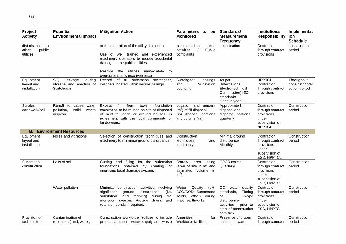
66
Project Activity
Potential Environmental Impact
Mitigation Action Parameters to be Monitored
Standards/ Measurement/ Frequency
Institutional Responsibility
Implementation Schedule
disturbance to other public utilities
and the duration of the utility disruption Use of well trained and experienced machinery operators to reduce accidental damage to the public utilities Restore the utilities immediately to overcome public inconvenience
commercial and public activities / Public complaints
specification Contractor through contract provisions
construction period
Equipment layout and installation
SF6 leakage during storage and erection of Switchgear
Record of all substation switchgear, cylinders located within secure casings
Switchgear casings and Substation bounding
As per (International Electro-technical Commission) IEC standards Once in year
HPPTCL Contractor through contract provisions
Throughout construction/erection period
Surplus earthwork/soil
Runoff to cause water pollution, solid waste disposal
Excess fill from tower foundation excavation to be reused on site or disposed of next to roads or around houses, in agreement with the local community or landowners.
Location and amount (m
3) of fill disposal
Soil disposal locations and volume (m
3)
Appropriate fill disposal and dispersal locations quarterly
Contractor through contract provisions under supervision of HPPTCL
Construction period
B. Environment Resources Equipment layout and installation
Noise and vibrations Selection of construction techniques and machinery to minimise ground disturbance.
Construction techniques and machinery
Minimal ground disturbance Monthly
Contractor through contract provisions under supervision of ESC, HPPTCL
Construction period
Substation construction
Loss of soil Cutting and filling for the substation foundations obtained by creating or improving local drainage system.
Borrow area siting (area of site in m
2 and
estimated volume in m
3)
CPCB norms Quarterly
Contractor through contract provisions under supervision of ESC, HPPTCL
Construction period
Water pollution Minimize construction activities involving significant ground disturbance (i.e. substation land forming) during the monsoon season. Provide drains and retention ponds if required.
Water Quality (pH, BOD/COD, Suspended solids, other) during major earthworks
GOI water quality standards, Timing of major disturbance activities - prior to start of construction activities
Contractor through contract provisions under supervision of ESC, HPPTCL
Construction period
Provision of facilities for
Contamination of receptors (land, water,
Construction workforce facilities to include proper sanitation, water supply and waste
Amenities for Workforce facilities
Presence of proper sanitation, water
Contractor through contract
Construction period
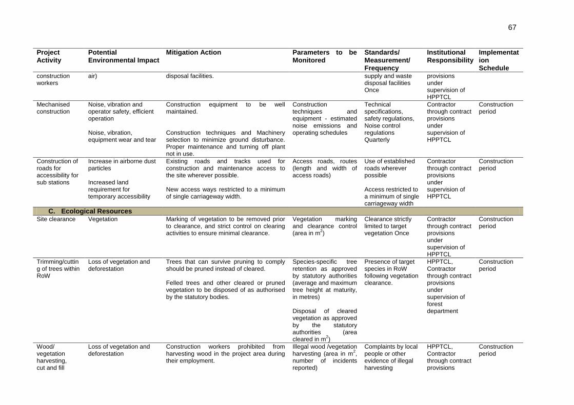
67
Project Activity
Potential Environmental Impact
Mitigation Action Parameters to be Monitored
Standards/ Measurement/ Frequency
Institutional Responsibility
Implementation Schedule
construction workers
air) disposal facilities. supply and waste disposal facilities Once
provisions under supervision of HPPTCL
Mechanised construction
Noise, vibration and operator safety, efficient operation Noise, vibration, equipment wear and tear
Construction equipment to be well maintained. Construction techniques and Machinery selection to minimize ground disturbance. Proper maintenance and turning off plant not in use.
Construction techniques and equipment - estimated noise emissions and operating schedules
Technical specifications, safety regulations, Noise control regulations Quarterly
Contractor through contract provisions under supervision of HPPTCL
Construction period
Construction of roads for accessibility for sub stations
Increase in airborne dust particles Increased land requirement for temporary accessibility
Existing roads and tracks used for construction and maintenance access to the site wherever possible. New access ways restricted to a minimum of single carriageway width.
Access roads, routes (length and width of access roads)
Use of established roads wherever possible Access restricted to a minimum of single carriageway width
Contractor through contract provisions under supervision of HPPTCL
Construction period
C. Ecological Resources Site clearance Vegetation Marking of vegetation to be removed prior
to clearance, and strict control on clearing activities to ensure minimal clearance.
Vegetation marking and clearance control (area in m
2)
Clearance strictly limited to target vegetation Once
Contractor through contract provisions under supervision of HPPTCL
Construction period
Trimming/cutting of trees within RoW
Loss of vegetation and deforestation
Trees that can survive pruning to comply should be pruned instead of cleared. Felled trees and other cleared or pruned vegetation to be disposed of as authorised by the statutory bodies.
Species-specific tree retention as approved by statutory authorities (average and maximum tree height at maturity, in metres) Disposal of cleared vegetation as approved by the statutory authorities (area cleared in m
2)
Presence of target species in RoW following vegetation clearance.
HPPTCL, Contractor through contract provisions under supervision of forest department
Construction period
Wood/ vegetation harvesting, cut and fill
Loss of vegetation and deforestation
Construction workers prohibited from harvesting wood in the project area during their employment.
Illegal wood /vegetation harvesting (area in m
2,
number of incidents reported)
Complaints by local people or other evidence of illegal harvesting
HPPTCL, Contractor through contract provisions
Construction period
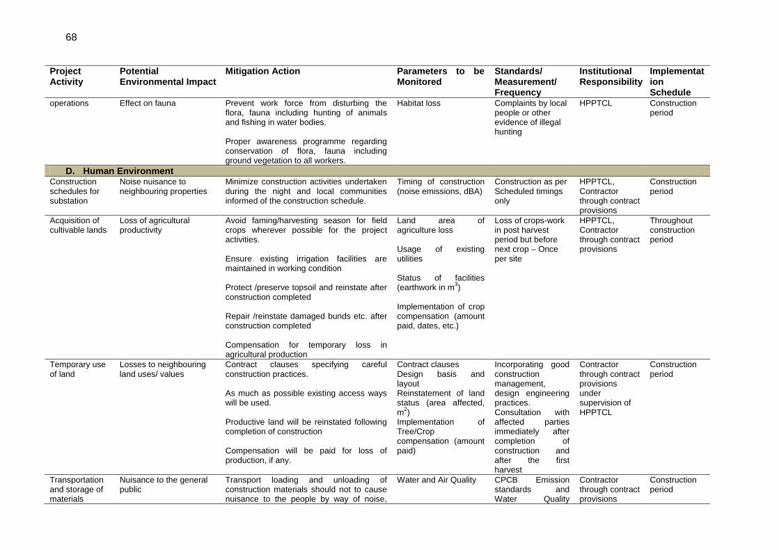
68
Project Activity
Potential Environmental Impact
Mitigation Action Parameters to be Monitored
Standards/ Measurement/ Frequency
Institutional Responsibility
Implementation Schedule
operations
Effect on fauna Prevent work force from disturbing the flora, fauna including hunting of animals and fishing in water bodies. Proper awareness programme regarding conservation of flora, fauna including ground vegetation to all workers.
Habitat loss Complaints by local people or other evidence of illegal hunting
HPPTCL
Construction period
D. Human Environment Construction schedules for substation
Noise nuisance to neighbouring properties
Minimize construction activities undertaken during the night and local communities informed of the construction schedule.
Timing of construction (noise emissions, dBA)
Construction as per Scheduled timings only
HPPTCL, Contractor through contract provisions
Construction period
Acquisition of cultivable lands
Loss of agricultural productivity
Avoid faming/harvesting season for field crops wherever possible for the project activities. Ensure existing irrigation facilities are maintained in working condition Protect /preserve topsoil and reinstate after construction completed Repair /reinstate damaged bunds etc. after construction completed Compensation for temporary loss in agricultural production
Land area of agriculture loss Usage of existing utilities Status of facilities (earthwork in m
3)
Implementation of crop compensation (amount paid, dates, etc.)
Loss of crops-work in post harvest period but before next crop – Once per site
HPPTCL, Contractor through contract provisions
Throughout construction period
Temporary use of land
Losses to neighbouring land uses/ values
Contract clauses specifying careful construction practices. As much as possible existing access ways will be used. Productive land will be reinstated following completion of construction Compensation will be paid for loss of production, if any.
Contract clauses Design basis and layout Reinstatement of land status (area affected, m
2)
Implementation of Tree/Crop compensation (amount paid)
Incorporating good construction management, design engineering practices. Consultation with affected parties immediately after completion of construction and after the first harvest
Contractor through contract provisions under supervision of HPPTCL
Construction period
Transportation and storage of materials
Nuisance to the general public
Transport loading and unloading of construction materials should not to cause nuisance to the people by way of noise,
Water and Air Quality CPCB Emission standards and Water Quality
Contractor through contract provisions
Construction period
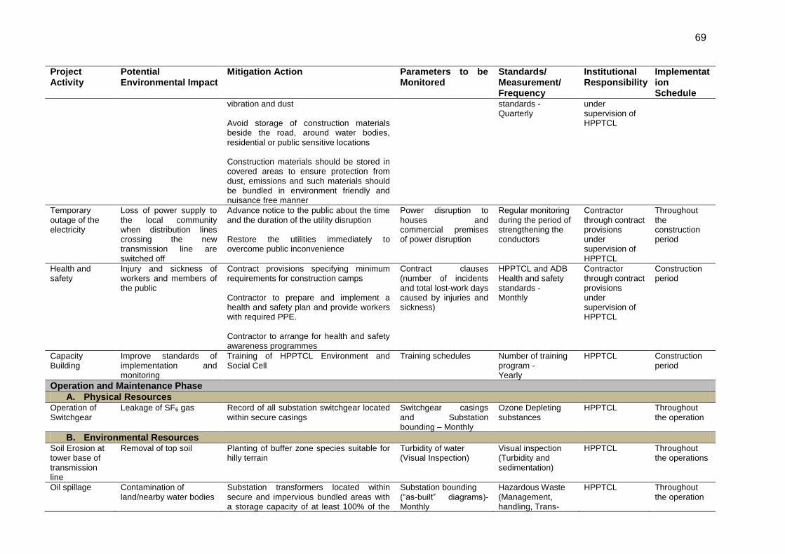
69
Project Activity
Potential Environmental Impact
Mitigation Action Parameters to be Monitored
Standards/ Measurement/ Frequency
Institutional Responsibility
Implementation Schedule
vibration and dust Avoid storage of construction materials beside the road, around water bodies, residential or public sensitive locations Construction materials should be stored in covered areas to ensure protection from dust, emissions and such materials should be bundled in environment friendly and nuisance free manner
standards - Quarterly
under supervision of HPPTCL
Temporary outage of the electricity
Loss of power supply to the local community when distribution lines crossing the new transmission line are switched off
Advance notice to the public about the time and the duration of the utility disruption Restore the utilities immediately to overcome public inconvenience
Power disruption to houses and commercial premises of power disruption
Regular monitoring during the period of strengthening the conductors
Contractor through contract provisions under supervision of HPPTCL
Throughout the construction period
Health and safety
Injury and sickness of workers and members of the public
Contract provisions specifying minimum requirements for construction camps Contractor to prepare and implement a health and safety plan and provide workers with required PPE. Contractor to arrange for health and safety awareness programmes
Contract clauses (number of incidents and total lost-work days caused by injuries and sickness)
HPPTCL and ADB Health and safety standards - Monthly
Contractor through contract provisions under supervision of HPPTCL
Construction period
Capacity Building
Improve standards of implementation and monitoring
Training of HPPTCL Environment and Social Cell
Training schedules Number of training program - Yearly
HPPTCL Construction period
Operation and Maintenance Phase
A. Physical Resources Operation of Switchgear
Leakage of SF6 gas Record of all substation switchgear located within secure casings
Switchgear casings and Substation bounding – Monthly
Ozone Depleting substances
HPPTCL Throughout the operation
B. Environmental Resources Soil Erosion at tower base of transmission line
Removal of top soil Planting of buffer zone species suitable for hilly terrain
Turbidity of water (Visual Inspection)
Visual inspection (Turbidity and sedimentation)
HPPTCL Throughout the operations
Oil spillage Contamination of land/nearby water bodies
Substation transformers located within secure and impervious bundled areas with a storage capacity of at least 100% of the
Substation bounding (―as-built‖ diagrams)-Monthly
Hazardous Waste (Management, handling, Trans-
HPPTCL Throughout the operation
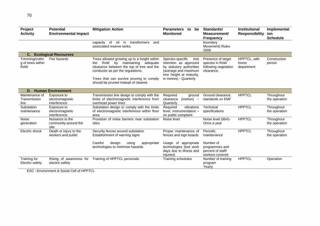
70
Project Activity
Potential Environmental Impact
Mitigation Action Parameters to be Monitored
Standards/ Measurement/ Frequency
Institutional Responsibility
Implementation Schedule
capacity of oil in transformers and associated reserve tanks.
boundary Movement) Rules 2009
C. Ecological Recourses Trimming/cutting of trees within RoW
Fire hazards
Trees allowed growing up to a height within the RoW by maintaining adequate clearance between the top of tree and the conductor as per the regulations. Trees that can survive pruning to comply should be pruned instead of cleared.
Species-specific tree retention as approved by statutory authorities (average and maximum tree height at maturity, in metres) - Quarterly
Presence of target species in RoW following vegetation clearance.
HPPTCL, with forest department
Construction period
D. Human Environment Maintenance of Transmission line
Exposure to electromagnetic interference
Transmission line design to comply with the limits of electromagnetic interference from overhead power lines
Required ground clearance (metres) – Quarterly
Ground clearance, standards on EMF
HPPTCL Throughout the operation
Substation maintenance
Exposure to electromagnetic interference
Substation design to comply with the limits of electromagnetic interference within floor area
Required vibrations level, instrumentation – on public complaint
Technical specifications
HPPTCL Throughout the operation
Noise generation
Nuisance to the community around the site
Provision of noise barriers near substation sites
Noise level Noise level (dbA)- Once a year
HPPTCL
Throughout the operation
Electric shock Death or injury to the workers and public
Security fences around substation Establishment of warning signs Careful design using appropriate technologies to minimise hazards
Proper maintenance of fences and sign boards Usage of appropriate technologies (lost work days due to illness and injuries)
Periodic maintenance Number of programmes and percent of staff/ workers covered
HPPTCL
Throughout the operation
Training for Electric safety
Rising of awareness for electric safety
Training of HPPTCL personals Training schedules Number of training program Yearly
HPPTCL Operation
ESC –Environment & Social Cell of HPPTCL
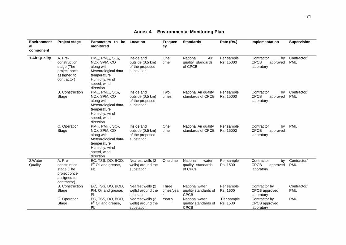
71
Annex 4 Environmental Monitoring Plan Environmental component
Project stage Parameters to be monitored
Location Frequency
Standards Rate (Rs.) Implementation Supervision
1.Air Quality
A. Pre-construction stage (The project once assigned to contractor)
PM10, PM2.5, SO2, NOx, SPM, CO along with Meteorological data- temperature Humidity, wind speed, wind direction
Inside and outside (0.5 km) of the proposed substation
One time
National Air quality standards of CPCB
Per sample Rs. 15000
Contractor by CPCB approved laboratory
Contractor/ PMU
B. Construction Stage
PM10, PM2.5, SO2, NOx, SPM, CO along with Meteorological data- temperature Humidity, wind speed, wind direction
Inside and outside (0.5 km) of the proposed substation
Two times
National Air quality standards of CPCB
Per sample Rs. 15000
Contractor by CPCB approved laboratory
Contractor/ PMU
C. Operation Stage
PM10, PM2.5, SO2, NOx, SPM, CO along with Meteorological data- temperature Humidity, wind speed, wind direction
Inside and outside (0.5 km) of the proposed substation
One time
National Air quality standards of CPCB
Per sample Rs. 15000
Contractor by CPCB approved laboratory
PMU
2.Water Quality
A. Pre-construction stage (The project once assigned to contractor)
EC, TSS, DO, BOD, P
H Oil and grease,
Pb,
Nearest wells (2 wells) around the substation
One time National water quality standards of CPCB
Per sample Rs. 1500
Contractor by CPCB approved laboratory
Contractor/ PMU
B. Construction Stage
EC, TSS, DO, BOD, PH, Oil and grease, Pb
Nearest wells (2 wells) around the substation
Three times/year
National water quality standards of CPCB
Per sample Rs. 1500
Contractor by CPCB approved laboratory
Contractor/ PMU
C. Operation Stage
EC, TSS, DO, BOD, P
H Oil and grease,
Pb
Nearest wells (2 wells) around the substation
Yearly National water quality standards of CPCB
Per sample Rs. 1500
Contractor by CPCB approved laboratory
PMU
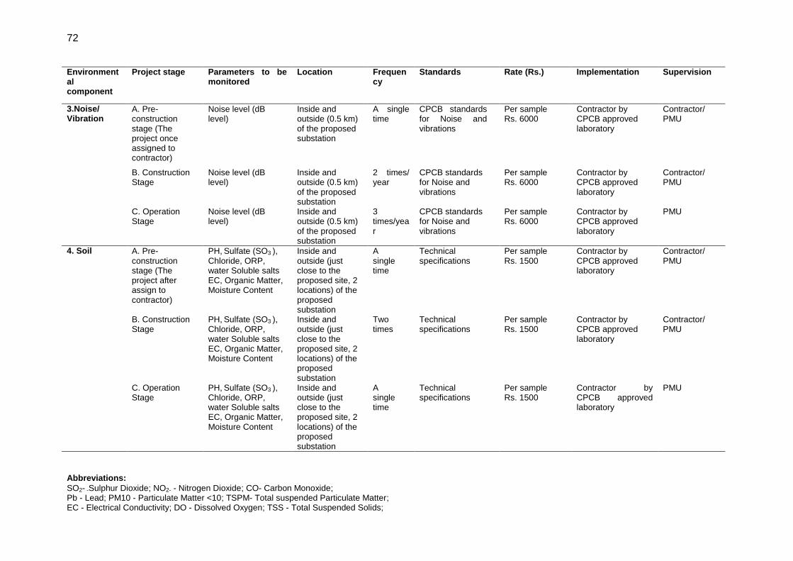
72
Environmental component
Project stage Parameters to be monitored
Location Frequency
Standards Rate (Rs.) Implementation Supervision
3.Noise/ Vibration
A. Pre-construction stage (The project once assigned to contractor)
Noise level (dB level)
Inside and outside (0.5 km) of the proposed substation
A single time
CPCB standards for Noise and vibrations
Per sample Rs. 6000
Contractor by CPCB approved laboratory
Contractor/ PMU
B. Construction Stage
Noise level (dB level)
Inside and outside (0.5 km) of the proposed substation
2 times/ year
CPCB standards for Noise and vibrations
Per sample Rs. 6000
Contractor by CPCB approved laboratory
Contractor/ PMU
C. Operation Stage
Noise level (dB level)
Inside and outside (0.5 km) of the proposed substation
3 times/year
CPCB standards for Noise and vibrations
Per sample Rs. 6000
Contractor by CPCB approved laboratory
PMU
4. Soil A. Pre-construction stage (The project after assign to contractor)
PH, Sulfate (SO3 ),
Chloride, ORP, water Soluble salts EC, Organic Matter, Moisture Content
Inside and outside (just close to the proposed site, 2 locations) of the proposed substation
A single time
Technical specifications
Per sample Rs. 1500
Contractor by CPCB approved laboratory
Contractor/ PMU
B. Construction Stage
PH, Sulfate (SO3 ),
Chloride, ORP, water Soluble salts EC, Organic Matter, Moisture Content
Inside and outside (just close to the proposed site, 2 locations) of the proposed substation
Two times
Technical specifications
Per sample Rs. 1500
Contractor by CPCB approved laboratory
Contractor/ PMU
C. Operation Stage
PH, Sulfate (SO3 ),
Chloride, ORP, water Soluble salts EC, Organic Matter, Moisture Content
Inside and outside (just close to the proposed site, 2 locations) of the proposed substation
A single time
Technical specifications
Per sample Rs. 1500
Contractor by CPCB approved laboratory
PMU
Abbreviations:
SO2- -Sulphur Dioxide; NO2- - Nitrogen Dioxide; CO- Carbon Monoxide; Pb - Lead; PM10 - Particulate Matter <10; TSPM- Total suspended Particulate Matter; EC - Electrical Conductivity; DO - Dissolved Oxygen; TSS - Total Suspended Solids;

73
BOD - Biological Oxygen Demand; NAAQS - National Ambient Air Quality Standards; NWQS - National water Quality Standards; HPPTCL – Himachal Pradesh Power Transmission Corporation Limited
Notes: Transport/Accommodation & Sample collection cost, VAT are not included for the EMoP. Source for Rates: MoEF (CPCB) New Delhi, Notification Dated 15 June 2008
Nearest Board’s Laboratory: Central Laboratory, H. P. State Environment Protection & Pollution Control Board, SCF 6, 7, 8, Sector-IV, Parwanoo, District. Solan-173 220, Himachal
Pradesh
74
Annex 5 Details of Public Consultations General Perception about Project 1. People of the area are very positive for this project which will give employment generation and development through income generation by selling of clean energy. The income generated by the project will insure better infrastructure development in the state and area. 2. Villagers of Hatkoti also appreciated the previous work done by the HPPCL for development of area of Hatkoti temple and sponsoring the education of many children of the area against the land acquired in the village. The only matter of concern for the villagers was losing orchards and fertile land. 3. Similarly people staying nearby area of proposed substation sites at Gumma (Pragati Nagar) and Sherpa Colony (Wangtoo) showed a positive response for the project as they felt that such projects will increase the importance of the area. However they did not want them to cause any disturbance to public staying nearby in nearby area such as dust emissions during construction phase. Support of local people for proposed project 4. All the villages covered under the consultation were ready to support the project. According to the villagers, such type of projects leads to infrastructure improvement in all aspects and they are also ready to support such environmental friendly projects proposed by the government. 5. Villagers of Katgaon (village near Sherpa Colony substation) and Bhagodi (village near Gumma Substation) ensured full support for the project. Critical issue and concern by the local people for the project 6. The villagers demanded that the line should avoid passing over through or nearby any habituated area and fertile lands. Villagers were concerned about the safety issues related to transmission line and requested proper education about probable harms of power transmission line to human and crops and required proper training to mitigate those harms. 7. For substations, villagers did not raise any critical concern as all three substation site are located very far away from habitation area of villages. Criteria liked to see during project design, operation stage, and construction 8. Rohru area of Shimla district is a rich apple producing belt of Himachal Pradesh and loosing land is major concern of the villagers. People wanted HPPTCL to avoid locating towers in fertile land and orchards and wanted proper compensation for land before start of project. 9. Villagers also demanded HPPTCL to avoid construction work during flowering season as the dust produce by construction may cause decrease in pollination of flowers and damage to crops production. The villagers also showed their concern about land sliding and soil erosion caused during the construction. Employment potential in the project 10. Almost all the villages felt that the project will definitely increase the employment potential of the villages. Villagers showed interest in getting involved in small construction, transportation, providing security and storage of material, and providing labour at the time of construction. A shopkeeper near Hatkoti village has informed his business had increased 10 times after start of construction of hydropower project work in the village. The villagers felt that the increase in income from electricity generation to the state will also lead to development in area and employment generation. 11. For substations, villagers demanded maximum employment to people staying nearby areas.
75
Ethnic Minorities 12. No ethnic minorities or vulnerable people are residing in Rohru area, The Kinnaur district is a tribal district but people are mainstreamed. Project will not have any impact of any ethnic communities of the area. Substations are located at far away from nearest habitations - Sherpa Colony (Wangtoo) Substation is located 14 km from Katgaon and Bhoktoo is located 7 km away from nearest habitation, Talangi. No of shops/commercial establishments 13. During consultation, it was noted that one or two shops were present in all villages covered in the project area, which comprise of daily need shops, tea shops and flour mills. Commercial establishment are situated within 10 km area of all the villages. 14. Katgaon village of Kinnaur has big commercial establishment for nearby areas for which most buyers come from nearby colonies of various hydroelectric projects located in the area. They are looking at positive prospects of increasing their commercial activities with this project also. Number of industrial units 15. There are no big industrial units surrounding the project area. Three villages, Kot, Magawata and Magara have wood cutting units in the area. Majority of villagers are involved in Agriculture, Horticulture and milk producing activities. Socio economic standing: land use, cropping pattern 16. In most villages, the major occupation of the people was horticulture and agriculture. Almost all farmers have own lands and they are involved in works related to horticulture, agriculture and animal husbandry. Along with agriculture, few people have their small shops in village and some villagers are employed by government in other parts of state. Sources of irrigation 17. Almost all the villagers are dependent upon rain water and snow for agriculture. Mostly, villagers use spring water with gravity gradient for irrigation but do not use water pumps for irrigation. Access to Forest Land and Use 18. The upper area of the mountains are having forests, villagers have access to forest for collection of fodder for the animals after taking permission from forest officials. Some forest lands are also encroached by villagers on which they have planted apple and other horticulture trees on encroached lands. Current rates for agricultural land 19. Buying and selling of land in the area has rarely been seen, so it’s difficult to calculate the actual market rate of land in the area. However, with the previous cases of compensation paid by the Public Works Department (PWD) for acquisition of lands, it is calculated as Rs. 0.15 million per Biswa6 of land in upper areas and Rs. 0.1 million per Biswa in lower area. Sources of power supply 20. All the areas covered during consultation were getting power from Himachal Pradesh State Electricity Board (HPSEB). Sources of electricity 21. Similarly, the source of electricity is HPSEB for all areas covered. Average total monthly expenditure per household on grid electricity 22. During consultation, the average monthly expenditure of electricity for domestic purpose was found to vary between Rs. 250-400. The average expenditure was about Rs. 200 per 2
6 1 Biswa is equal to 38 m
2
76
months for most of the villages. Other non-grid electricity to use in your village and expenditure Nothing. Source of drinking water 23. The household connection to each house of villages is through the Irrigation and Public Health department. Besides government connection, hand pump and natural water falls of mountain are used in some villages. Availability of water is often a problem during the summers. Shortage of water 24. Sometimes availability of water is a problem during summer season. Rest of the year, water is available for all domestic needs. Availability of water is also dependent on snowfall occurring during winter. A good snowfall can fulfil demands of water for entire year. 25. During consultation, no negative impact on food grain, availability/land use was reported; landslides and soil erosion may cause due to project activities will damage the fertile top soil and standing crops below the tower leg. The villages reported that the project will not any cause widespread imbalance, no displacement of people is involved in the project. It was perceived that no electromagnetic radiations of transmission line may cause some health and safety issues for those villagers should be educated to mitigate such issues. Protected areas 26. There are no protected areas within 10 km vicinity of sub-projects and will not have any negative impact due to project activities. Health status 27. The health status of villagers is good. There have been no chronic diseases or health disaster or outburst of any disease is reported in recent past. In most of the villages primary health centres are not present, but they are available with in area of 3-5 km from village, the people usually travel towards nearby town to access medical services such as Kotkhai, Jubbal, Rohru, Rekong Peo and Shimla. Villagers are aware of HIV/AIDS and about sexually transmitted diseases. 28. The villagers felt that the project would not change permanent migration pattern, there will be no adverse impact on water by project activities but soil erosion needed to be taken care as digging for tower base may cause small land slide and damage of crops in nearby area. Educational status 29. Literacy rate in most of the villages are around 90-100%. A primary school is present in the village or nearby village. For middle level and high school, the villagers mostly go outside. Some villages reported of having a high school. Villagers have to go to nearby urban area for their higher education; it was found that the education level of boys and girls are at par. Employment status 30. Most of the villagers were engaged in horticulture, agricultural and agriculture related activities throughout the year. Among the youth, unemployment is about 40-50%. In the villages, which are in close proximity to urban towns, some of them are engaged in jobs and also carry small business. Perceived benefits from project 31. Most of the villages perceive that the project will result in provision of employment, small construction works, transportation works and development of basic infrastructure like roads, small commercial establishment. Village Committee 32. In all the villages, the decisions are taken by gram Panchayat and gram Sabha held on any
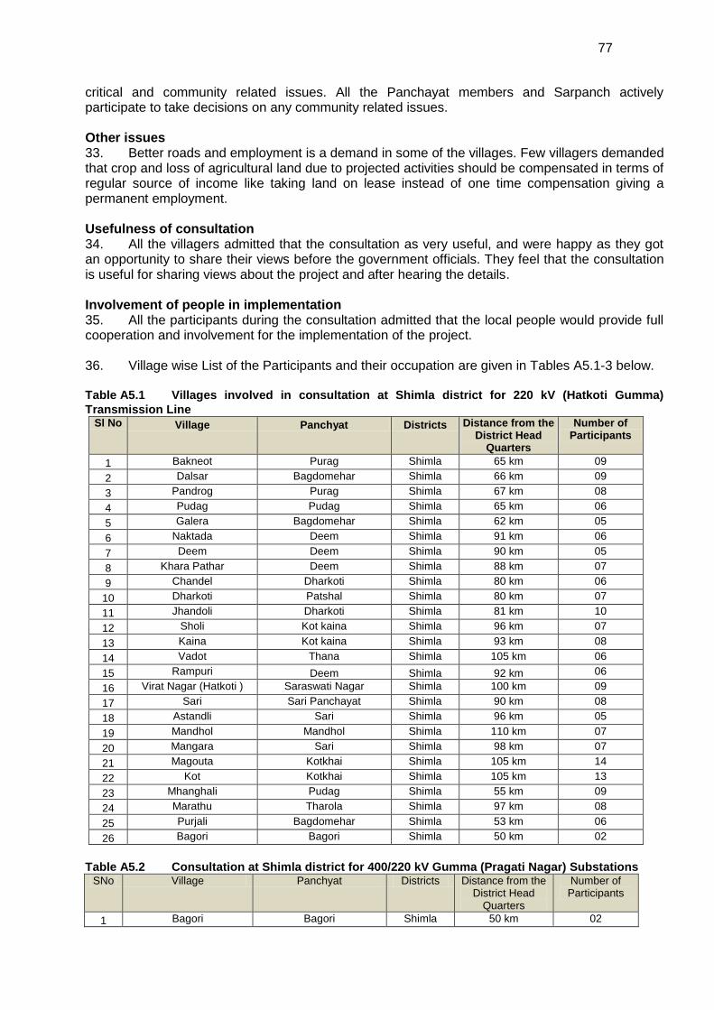
77
critical and community related issues. All the Panchayat members and Sarpanch actively participate to take decisions on any community related issues. Other issues 33. Better roads and employment is a demand in some of the villages. Few villagers demanded that crop and loss of agricultural land due to projected activities should be compensated in terms of regular source of income like taking land on lease instead of one time compensation giving a permanent employment. Usefulness of consultation 34. All the villagers admitted that the consultation as very useful, and were happy as they got an opportunity to share their views before the government officials. They feel that the consultation is useful for sharing views about the project and after hearing the details. Involvement of people in implementation 35. All the participants during the consultation admitted that the local people would provide full cooperation and involvement for the implementation of the project. 36. Village wise List of the Participants and their occupation are given in Tables A5.1-3 below.
Table A5.1 Villages involved in consultation at Shimla district for 220 kV (Hatkoti Gumma)
Transmission Line Sl No Village Panchyat Districts Distance from the
District Head Quarters
Number of Participants
1 Bakneot Purag Shimla 65 km 09
2 Dalsar Bagdomehar Shimla 66 km 09
3 Pandrog Purag Shimla 67 km 08
4 Pudag Pudag Shimla 65 km 06
5 Galera Bagdomehar Shimla 62 km 05
6 Naktada Deem Shimla 91 km 06
7 Deem Deem Shimla 90 km 05
8 Khara Pathar Deem Shimla 88 km 07
9 Chandel Dharkoti Shimla 80 km 06
10 Dharkoti Patshal Shimla 80 km 07
11 Jhandoli Dharkoti Shimla 81 km 10
12 Sholi Kot kaina Shimla 96 km 07
13 Kaina Kot kaina Shimla 93 km 08
14 Vadot Thana Shimla 105 km 06
15 Rampuri Deem Shimla 92 km 06
16 Virat Nagar (Hatkoti ) Saraswati Nagar Shimla 100 km 09
17 Sari Sari Panchayat Shimla 90 km 08
18 Astandli Sari Shimla 96 km 05
19 Mandhol Mandhol Shimla 110 km 07
20 Mangara Sari Shimla 98 km 07
21 Magouta Kotkhai Shimla 105 km 14
22 Kot Kotkhai Shimla 105 km 13
23 Mhanghali Pudag Shimla 55 km 09
24 Marathu Tharola Shimla 97 km 08
25 Purjali Bagdomehar Shimla 53 km 06
26 Bagori Bagori Shimla 50 km 02
Table A5.2 Consultation at Shimla district for 400/220 kV Gumma (Pragati Nagar) Substations SNo Village Panchyat Districts Distance from the
District Head Quarters
Number of Participants
1 Bagori Bagori Shimla 50 km 02
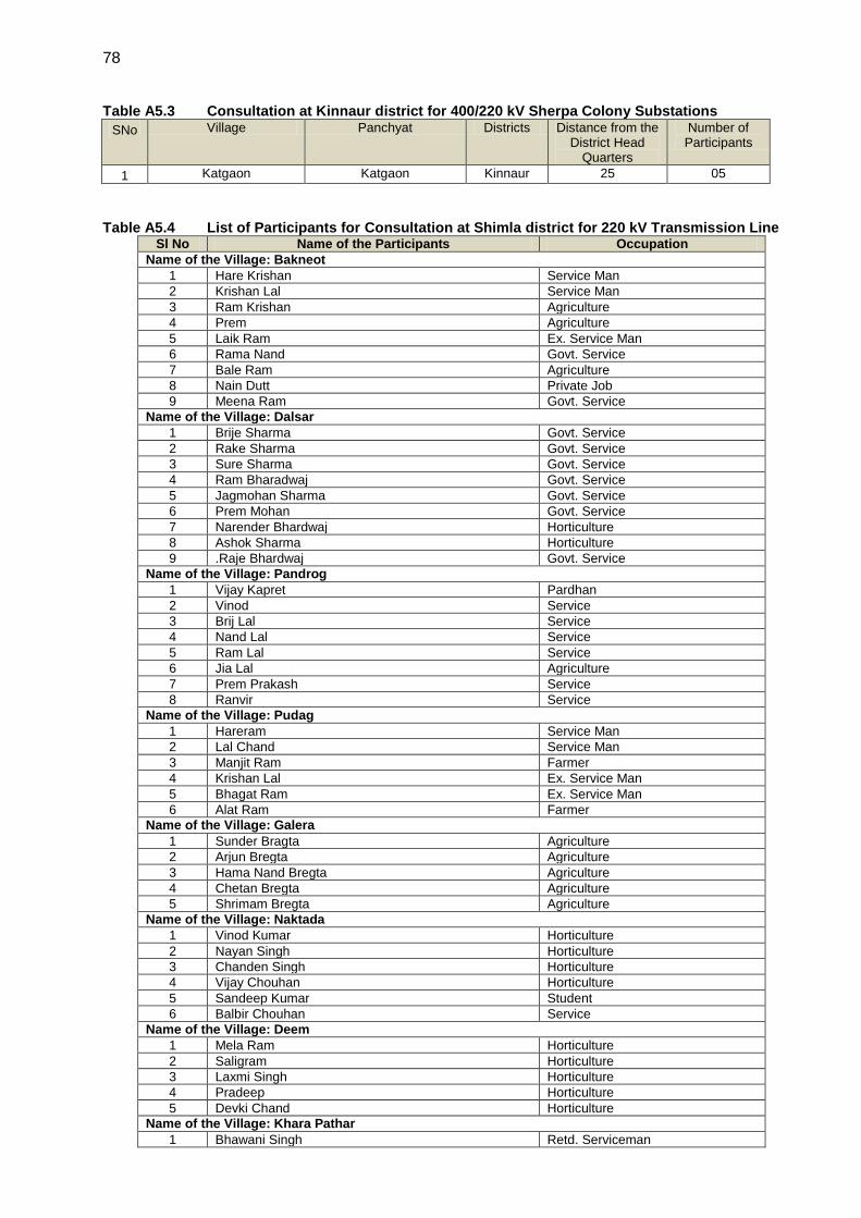
78
Table A5.3 Consultation at Kinnaur district for 400/220 kV Sherpa Colony Substations
SNo Village Panchyat Districts Distance from the District Head
Quarters
Number of Participants
1 Katgaon Katgaon Kinnaur 25 05
Table A5.4 List of Participants for Consultation at Shimla district for 220 kV Transmission Line Sl No Name of the Participants Occupation
Name of the Village: Bakneot
1 Hare Krishan Service Man
2 Krishan Lal Service Man
3 Ram Krishan Agriculture
4 Prem Agriculture
5 Laik Ram Ex. Service Man
6 Rama Nand Govt. Service
7 Bale Ram Agriculture
8 Nain Dutt Private Job
9 Meena Ram Govt. Service
Name of the Village: Dalsar
1 Brije Sharma Govt. Service
2 Rake Sharma Govt. Service
3 Sure Sharma Govt. Service
4 Ram Bharadwaj Govt. Service
5 Jagmohan Sharma Govt. Service
6 Prem Mohan Govt. Service
7 Narender Bhardwaj Horticulture
8 Ashok Sharma Horticulture
9 .Raje Bhardwaj Govt. Service
Name of the Village: Pandrog
1 Vijay Kapret Pardhan
2 Vinod Service
3 Brij Lal Service
4 Nand Lal Service
5 Ram Lal Service
6 Jia Lal Agriculture
7 Prem Prakash Service
8 Ranvir Service
Name of the Village: Pudag
1 Hareram Service Man
2 Lal Chand Service Man
3 Manjit Ram Farmer
4 Krishan Lal Ex. Service Man
5 Bhagat Ram Ex. Service Man
6 Alat Ram Farmer
Name of the Village: Galera
1 Sunder Bragta Agriculture
2 Arjun Bregta Agriculture
3 Hama Nand Bregta Agriculture
4 Chetan Bregta Agriculture
5 Shrimam Bregta Agriculture
Name of the Village: Naktada
1 Vinod Kumar Horticulture
2 Nayan Singh Horticulture
3 Chanden Singh Horticulture
4 Vijay Chouhan Horticulture
5 Sandeep Kumar Student
6 Balbir Chouhan Service
Name of the Village: Deem
1 Mela Ram Horticulture
2 Saligram Horticulture
3 Laxmi Singh Horticulture
4 Pradeep Horticulture
5 Devki Chand Horticulture
Name of the Village: Khara Pathar
1 Bhawani Singh Retd. Serviceman
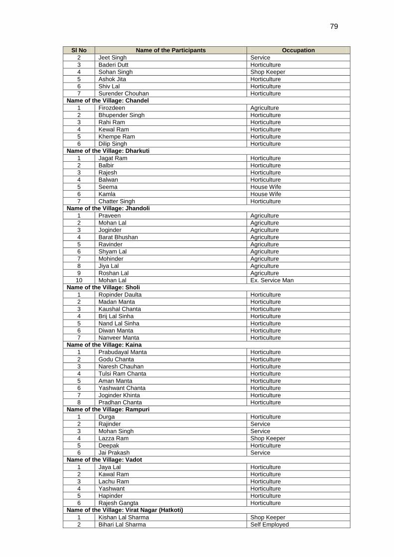
79
Sl No Name of the Participants Occupation
2 Jeet Singh Service
3 Baderi Dutt Horticulture
4 Sohan Singh Shop Keeper
5 Ashok Jita Horticulture
6 Shiv Lal Horticulture
7 Surender Chouhan Horticulture
Name of the Village: Chandel
1 Firozdeen Agriculture
2 Bhupender Singh Horticulture
3 Rahi Ram Horticulture
4 Kewal Ram Horticulture
5 Khempe Ram Horticulture
6 Dilip Singh Horticulture
Name of the Village: Dharkuti
1 Jagat Ram Horticulture
2 Balbir Horticulture
3 Rajesh Horticulture
4 Balwan Horticulture
5 Seema House Wife
6 Kamla House Wife
7 Chatter Singh Horticulture
Name of the Village: Jhandoli
1 Praveen Agriculture
2 Mohan Lal Agriculture
3 Joginder Agriculture
4 Barat Bhushan Agriculture
5 Ravinder Agriculture
6 Shyam Lal Agriculture
7 Mohinder Agriculture
8 Jiya Lal Agriculture
9 Roshan Lal Agriculture
10 Mohan Lal Ex. Service Man
Name of the Village: Sholi
1 Ropinder Daulta Horticulture
2 Madan Manta Horticulture
3 Kaushal Chanta Horticulture
4 Brij Lal Sinha Horticulture
5 Nand Lal Sinha Horticulture
6 Diwan Manta Horticulture
7 Nanveer Manta Horticulture
Name of the Village: Kaina
1 Prabudayal Manta Horticulture
2 Godu Chanta Horticulture
3 Naresh Chauhan Horticulture
4 Tulsi Ram Chanta Horticulture
5 Aman Manta Horticulture
6 Yashwant Chanta Horticulture
7 Joginder Khinta Horticulture
8 Pradhan Chanta Horticulture
Name of the Village: Rampuri
1 Durga Horticulture
2 Rajinder Service
3 Mohan Singh Service
4 Lazza Ram Shop Keeper
5 Deepak Horticulture
6 Jai Prakash Service
Name of the Village: Vadot
1 Jaya Lal Horticulture
2 Kawal Ram Horticulture
3 Lachu Ram Horticulture
4 Yashwant Horticulture
5 Hapinder Horticulture
6 Rajesh Gangta Horticulture
Name of the Village: Virat Nagar (Hatkoti)
1 Kishan Lal Sharma Shop Keeper
2 Bihari Lal Sharma Self Employed
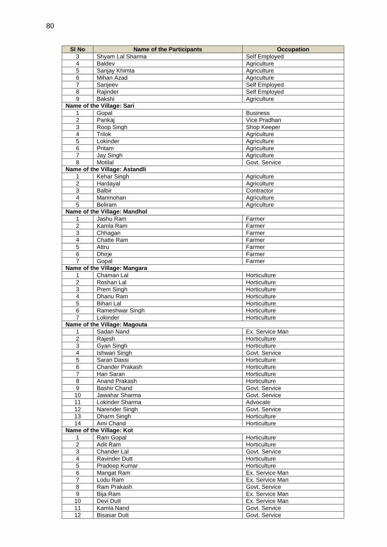
80
Sl No Name of the Participants Occupation
3 Shyam Lal Sharma Self Employed
4 Baldev Agriculture
5 Sanjay Khimta Agriculture
6 Mihan Azad Agriculture
7 Sanjeev Self Employed
8 Rajinder Self Employed
9 Bakshi Agriculture
Name of the Village: Sari
1 Gopal Business
2 Pankaj Vice Pradhan
3 Roop Singh Shop Keeper
4 Trilok Agriculture
5 Lokinder Agriculture
6 Pritam Agriculture
7 Jay Singh Agriculture
8 Motilal Govt. Service
Name of the Village: Astandli
1 Kehar Singh Agriculture
2 Hardayal Agriculture
3 Balbir Contractor
4 Manmohan Agriculture
5 Beliram Agriculture
Name of the Village: Mandhol
1 Jashu Ram Farmer
2 Kamla Ram Farmer
3 Chhagan Farmer
4 Chatte Ram Farmer
5 Attru Farmer
6 Dhirje Farmer
7 Gopal Farmer
Name of the Village: Mangara
1 Chaman Lal Horticulture
2 Roshan Lal Horticulture
3 Prem Singh Horticulture
4 Dhanu Ram Horticulture
5 Bihari Lal Horticulture
6 Rameshwar Singh Horticulture
7 Lokinder Horticulture
Name of the Village: Magouta
1 Sadan Nand Ex. Service Man
2 Rajesh Horticulture
3 Gyan Singh Horticulture
4 Ishwari Singh Govt. Service
5 Saran Dassi Horticulture
6 Chander Prakash Horticulture
7 Hari Saran Horticulture
8 Anand Prakash Horticulture
9 Bashir Chand Govt. Service
10 Jawahar Sharma Govt. Service
11 Lokinder Sharma Advocate
12 Narender Singh Govt. Service
13 Dharm Singh Horticulture
14 Ami Chand Horticulture
Name of the Village: Kot
1 Ram Gopal Horticulture
2 Adit Ram Horticulture
3 Chander Lal Govt. Service
4 Ravinder Dutt Horticulture
5 Pradeep Kumar Horticulture
6 Mangat Ram Ex. Service Man
7 Lodu Ram Ex. Service Man
8 Ram Prakash Govt. Service
9 Bija Ram Ex. Service Man
10 Devi Dutt Ex. Service Man
11 Kamla Nand Govt. Service
12 Bisasar Dutt Govt. Service

81
Sl No Name of the Participants Occupation
13 Payari Lal Govt. Service
Name of the Village: Mhanghali
1 Narayan Dass Govt. Service
2 Sati Kumar Self
3 Daulat Ram Ex.Service Man
4 Mehu Ram Self Employed
5 Rajinder Singh Agriculture
6 Jai Ram Agriculture
7 Daulat Ram Ex.Service Man
8 Rati Ram Agriculture
9 Chet Ram Govt.Service
Name of the Village: Marathu
1 Jagdish Govt.Service
2 Ravinder Agriculture
3 Suresh Agriculture
4 Roshan Agriculture
5 Mahinder Agriculture
6 Subhadra Agriculture
7 Dharpal Agriculture
8 Durga Singh Agriculture
Name of the Village: Purjali
1 Agya Ram Horticulture
2 Kapil Dev Horticulture
3 Punji Ram Horticulture
4 Laik Ram Horticulture
5 Sendar Singh Horticulture
6 Bal Krishan Horticulture
Table A5.5 List Of Participants For Consultation In Shimla district For Gumma (Pragati Nagar) Substation
Name of the Village: Bagori (For Gumma Sub Station)
1 N D Chauhan Business
2 Rati Ram Agriculture
Table A5.6 List of Participants for Consultation In Kinnaur district for Sherpa Colony (Wangtoo) Substation
Name of the Village: Katgaon (For Sherpa Colony Substation At Kinnaur)
1 Prabhulal Negi Retired Govt. Servant
2 Ravi Negi Horticulture
3 Harman Dass Ex Army Officer
4 Pratap Negi Shop Keeper
5 Shiv Singh Govt. Employee