INFRASTRUCTURE OUTLINE CONCEPT PLAN: KABUPATEN...
119
INFRASTRUCTURE OUTLINE CONCEPT PLAN: KABUPATEN ACEH JAYA WATER, SANITATION, SOLID WASTE, DRAINAGE FEBRUARY 2006 This publication was produced by Development Alternatives, Inc. for review by the United States Agency for International Development under Contract No. 497-M-00-5-00005-00
Transcript of INFRASTRUCTURE OUTLINE CONCEPT PLAN: KABUPATEN...

INFRASTRUCTURE OUTLINE CONCEPT PLAN: KABUPATEN ACEH JAYA WATER, SANITATION, SOLID WASTE, DRAINAGE
FEBRUARY 2006 This publication was produced by Development Alternatives, Inc. for review by the United States Agency for International Development under Contract No. 497-M-00-5-00005-00


TABLE OF CONTENTS
LIST OF FIGURES...................................................................................................................... II LIST OF TABLES ......................................................................................................................III LIST OF ACRONYMS ..............................................................................................................IV EXECUTIVE SUMMARY........................................................................................................... 1 1. INTRODUCTION .............................................................................................................. 1 2. LOCATION, GEOGRAPHY, AND KECAMATANS (SUB-DISTRICTS).................... 3 3. EARTHQUAKE AND TSUNAMI IMPACTS .................................................................. 6
A. CONDITIONS BEFORE AND AFTER ...............................................................................................................6 B. INTERNALLY DISPLACED PERSONS................................................................................................................8 C. GOI-GAM CONFLICT...................................................................................................................................8
4. GOVERNMENT INSTITUTIONS AND ACEH ADAT ORGANIZATIONS ............ 10 D. ADAT ORGANIZATIONS............................................................................................................................. 10 E. BADAN REHABILITASI DAN REKONSTRUKSI (BRR) .................................................................................. 11
5. LEVEL OF SERVICE TARGETS..................................................................................... 12 F. RESIDENTIAL HOUSING............................................................................................................................... 12 G. LEVEL OF SERVICE COVERAGE .................................................................................................................... 14
6. NGO AND DONOR ACTIVITIES: WATSAN AND SHELTER................................. 15 H. GENERAL DISCUSSION ................................................................................................................................ 15 I. NGO AND DONOR ACTIVITIES IN KABUPATEN ACEH JAYA ................................................................. 16 J. HOUSING (SHELTER) ACTIVITIES IN KABUPATEN ACEH JAYA................................................................. 18
7. EXPECTED DEVELOPMENT AND GROWTH .......................................................... 20 8. POPULATION PROJECTIONS ..................................................................................... 22 9. WATER INFRASTRUCTURE, SOURCES AND DEMAND ....................................... 24
K. CURRENT SITUATION ................................................................................................................................. 24 KECAMATAN JAYA................................................................................................................ 24 IN LAMNO, OXFAM PROVIDED EMERGENCY WATER SUPPLY AND IS FUNDING DESIGN OF A PERMANENT SYSTEM. OXFAM ACTIVITIES IN WATER SUPPLY INCLUDE: ................................................................................................................................. 24 KECAMATAN SAMPOINIET AND KECAMATAN SETIA BAKTI................................... 24 CALANG ................................................................................................................................... 24 KECAMATAN KRUENG SABEE ........................................................................................... 24 KECAMATAN PANGA ........................................................................................................... 24 KECAMATAN TEUNOM........................................................................................................ 25 DUG WELLS............................................................................................................................. 25
L. WATER QUALITY ........................................................................................................................................ 26 M. WATER SOURCES ................................................................................................................................... 28 N. ESTIMATED WATER DEMAND .................................................................................................................... 29 O. WATER SYSTEM STRATEGY......................................................................................................................... 32 P. FUTURE WATER SUPPLY INFRASTRUCTURE .............................................................................................. 34
LAMNO (KECAMATAN JAYA) ............................................................................................. 34 10. SANITATION (HUMAN WASTE) INFRASTRUCTURE....................................... 42
Q. CURRENT SITUATION FOR DISPOSAL OF WASTEWATER ........................................................................ 42 R. SEPTAGE COLLECTION AND TREATMENT................................................................................................. 45 S. FUTURE FACILITIES FOR SANITATION ........................................................................................................ 46
11. SOLID WASTE INFRASTRUCTURE........................................................................ 50 T. CURRENT SITUATION FOR SOLID WASTE COLLECTION AND DISPOSAL .............................................. 50 U. ESTIMATED SOLID WASTE PRODUCTION................................................................................................. 50 V. PRIVATE SECTOR PARTICIPATION IN SOLID WASTE SECTOR ................................................................. 52 W. STRATEGY FOR SOLID WASTE INFRASTRUCTURE................................................................................ 53 X. FUTURE FACILITIES FOR SOLID WASTE COLLECTION AND DISPOSAL ................................................... 53
11.1.1. Transfer Sites................................................................................................................................................ 53 11.1.2. Final Disposal Sites...................................................................................................................................... 54
12. DRAINAGE INFRASTRUCTURE .............................................................................. 55 Y. RIVER FLOODING ........................................................................................................................................ 56 Z. COASTAL FLOODING AND PROTECTION................................................................................................. 59 AA. REBUILDING HOUSES ON FLOOD PRONE LAND................................................................................. 62
13. OTHER INFRASTRUCTURE ..................................................................................... 63 BB. WATER SUPPLY....................................................................................................................................... 65 CC. SANITATION............................................................................................................................................ 65 DD. SOLID WASTE ......................................................................................................................................... 66 EE. DRAINAGE............................................................................................................................................... 67
14. ENVIRONMENTAL ANALYSIS OF INFRASTRUCTURE PROJECTS................. 69 15. ESTABLISHING PRIORITIES .................................................................................... 71 16. PROPOSED COMMITMENTS ................................................................................... 73 17. SUMMARY OF INFRASTRUCTURE NEEDS........................................................... 75 APPENDICES ........................................................................................................................... 81
A. SOURCES OF DATA ..................................................................................................................................... 81 B. NGO AND DONOR ORGANIZATIONS INTERVIEWED FOR THIS REPORT............................................. 81 C. EXAMPLES OF NGO ACTIVITIES OCT 05—JAN-06 (REPORTED BY KECAMATAN) .............................. 81

LIST OF FIGURES FIGURE 1: METHODOLOGY ..........................................................................................................................................2 FIGURE 2: MAP OF KABUPATEN ACEH JAYA ...............................................................................................................3 FIGURE 3: KECAMATANS IN KABUPATEN ACEH JAYA................................................................................................4 FIGURE 4: BRR ORGANIZATION CHART................................................................................................................. 11 FIGURE 5: DISTANCES BETWEEN KECAMATAN CAPITALS (IKK) ........................................................................... 21 FIGURE 6: TYPICAL TWO TANKS SEPTIC SYSTEM.................................................................................................... 44 FIGURE 7: FLOW SCHEME FOR IPLT STABILIZATION PONDS................................................................................. 46 FIGURE 8: KRUENG TEUNOM RIVER EMBANKMENT BREAK.................................................................................... 57 FIGURE 9: KRUENG TEUNOM EMBANKMENT SKETCH............................................................................................ 58 FIGURE 10: MAP OF MANGROVE LOCATIONS—ACEH YEAR 2000 ...................................................................... 61


LIST OF TABLES TABLE 1: FROM PLAN TO STRUCTURE ........................................................................................................................1 TABLE 2: KAB. ACEH JAYA KECAMATAN AREAS, IBU-KOTAS, AND DESAS .............................................................4 TABLE 3: KAB. ACEH JAYA YEAR 2005 POPULATION AND DENSITY .......................................................................5 TABLE 4: YEAR 2003 INFRASTRUCTURE SERVICES IN KAB ACEH JAYA.....................................................................7 TABLE 5: DETAILS ABOUT WATER SUPPLY BEFORE 26 DECEMBER 2004.................................................................7 TABLE 6: KAB. ACEH JAYA IDP STATUS OCTOBER 2005 .........................................................................................8 TABLE 7: NGOS DOING SHELTER, WATER, & SANITATION IN KAB. ACEH JAYA............................................... 17 TABLE 8: KAB. ACEH JAYA HOUSING STATUS—NOV.05 ...................................................................................... 18 TABLE 9: BANDA ACEH-MEULABOH ROAD SPECIFICATIONS ................................................................................ 20 TABLE 10: KAB. ACEH JAYA POPULATION FOR YEAR 2005................................................................................... 22 TABLE 11: KECAMATAN HISTORICAL POPULATION DATA.................................................................................... 22 TABLE 12: PROJECTED POPULATION FOR KAB. ACEH JAYA .................................................................................. 23 TABLE 13: PH AND SALINITY AT LOCATIONS CLOSE TO THE OCEAN................................................................. 27 TABLE 14: POTENTIAL WATER SOURCES IN KAB. ACEH JAYA .............................................................................. 28 TABLE 15: ESTIMATED POPULATION DENSITIES AND WATER DEMAND USED.................................................... 30 TABLE 16: ESTIMATED WATER DEMAND FOR KAB. ACEH JAYA ........................................................................... 30 TABLE 17: RECOMMENDED SIZE OF WATER SUPPLY FOR KAB. ACEH JAYA......................................................... 31 TABLE 18: COST COMPARISON OF HDPE AND PVC PIPE .................................................................................... 33 TABLE 19: SAMPOINIET WATER SUPPLY SCHEMES .................................................................................................. 36 TABLE 20: CALANG WATER SUPPLY SCHEMES........................................................................................................ 38 TABLE 21: TEUNOM WATER SUPPLY SCHEMES ....................................................................................................... 40 TABLE 22: ACEH JAYA WATER SUPPLY SCHEMES.................................................................................................... 41 TABLE 23: ESTIMATED SEPTAGE PRODUCTION YEAR 2010................................................................................... 47 TABLE 24: SIZE AND AREA FOR IPLTS IN ACEH JAYA............................................................................................. 47 TABLE 25: SOLID WASTE PRODUCTION FROM VARIOUS SOURCES...................................................................... 50 TABLE 26: SOLID WASTE PRODUCTION 2006--2010............................................................................................ 51 TABLE 27: TEUNOM DESA AFFECTED BY RIVER FLOODING................................................................................... 57 TABLE 28: GOVERNMENT OF INDONESIA THRESHOLD CRITERIA FOR PROJECTS REQUIRING ENVIRONMENTAL
REVIEW (AMDAL OR UKL/UPL) .................................................................................................................. 69 TABLE 29: CRITERIA, SUB-DIVISIONS, AND ASSIGNED POINTS.............................................................................. 71 TABLE 30: DATA FOR ESTABLISHING PRIORITIES FOR KECAMATAN DEVELOPMENT ........................................... 72 TABLE 31: KECAMATANS PRIORITIZED FOR DEVELOPMENT .................................................................................. 72 TABLE 32: WATER SUPPLY PROGRAM & INDICATIVE COSTS................................................................................. 76 TABLE 33: SANITATION PROGRAM & INDICATIVE COSTS...................................................................................... 78 TABLE 34: SOLID WASTE PROGRAM & INDICATIVE COSTS ................................................................................... 79 TABLE 35: DRAINAGE PROGRAM & INDICATIVE COSTS......................................................................................... 80


LIST OF ACRONYMS Adat customary law based on local and religious traditions and practices
AMDAL Analisa Mengenai Dampak Lingkungan (Environmental Impact Review)
BAPPEDA Badan Perencanaan Pembangunan Daerah (Regional Planning Board)
BAPPENAS Badan Perencanaan Pembangunan Nasional (National Development
Planning Agency)
BRR Badan Rehabilitasi dan Rekonstruksi
(Rehabilitation and Reconstruction Board)
Bupati Head of Kabupaten (District)
Camat Head of Kecamatan (Sub-District)
DED Detailed Engineering Design
Desa Village
Dinas
Kebersihan
Sanitation Department
DPRD Dewan Perwakilan Rakyat Daerah
FS Feasibility Studies
GAM Gerakan Aceh Merdeka (Free Aceh Movement)
GOI Government of Indonesia
HDPE High Density Poly Ethylene (Technical name is PE-100)
HIPAM Himpunan Pengelola Air Minum
(Community Managed Water System)
also known as OPAM (Organisasi Pengguna Air Minum)
IKK Ibu Kota Kecamatan; Principal town, often the capital
IMB Izin Mendirikan Bangunan (Building Permit)
IPLT Instalasi Pengolahan Lumpur Tinja
(Septage Treatment Plant)
Kabupaten District; administrative subdivision of a Province
Kecamatan administrative subdivision of a Kabupaten (sub-district)
km Kilometer = 1000 meters = 0.6 mile
Kr. Krueng (river)
L/c/d Liter per Capita per Day
L/s Liters per second

m meter = 1000 millimeters (mm)
m3 cubic meters = 1000 Liters
MIIP Market Infrastructure Improvement Program
msl Mean Sea Level
Mukim Aceh Province administrative unit between Kecamatan and Desa
NAD Nanggroe Aceh Darussalam (official name of Aceh Province)
NGO Non-Government Organization
O&M Operations and Maintenance
PDAM Perusahan Daerah Air Minum
(authority responsible for drinking water supply)
PED Preliminary Engineering Design
PU Pekerjaan Umum (Department of Public Works)
Rp Rupiah (currency of Indonesia)
TOR Terms of Reference
TPA Tempat Pembuangan Sampah Akhir
(Solid Waste Final Disposal Site)
TPS Tempat Pembuangan Sementara (Transfer Station)
Wilayah Region


EXECUTIVE SUMMARY The objective of this report is to describe the current status of water supply, sanitation, solid waste, and drainage infrastructure and services in Kabupaten Aceh Jaya, identify infrastructure needed to provide planned levels of service; and recommend infrastructure improvements during the period 2006 to 2010. This report focuses on permanent infrastructure supporting permanent housing. It analyzes and forecasts at Kecamatan (sub-district) level because: • it is easier to get data and to analyze than Desa---there are 6 Kecamatan but 173
Gampong (Desa) in the Kabupaten • this level of government can coordinate among the Desa for use of limited resources
such as waste collection vehicles • this level of government has responsibility for markets (major source of solid waste) and
for maintenance of micro-drainage. The chapters for each infrastructure sector start with a description of current activities; discuss methods, concepts, and strategies for providing service; and propose Outline Plans for the design and construction of facilities. This report can be used to: • Plan and budget infrastructure for the period 2006 to 2010 • Learn about the Kabupaten and institutions involved in infrastructure • Serve as a model for forecasting infrastructure services at other locations. Data in the report comes from site visits, interviews, and reports collected by the ESP-Aceh Needs Assessment Team which arrived in Banda Aceh on 17 November 2005. To estimate quantities standard values and assumptions were used which should be verified through field measurements. Activities continue at a fast pace and new programs begin, so this report is only a snapshot at a particular point in time. It must be updated. In particular, changes in population need to be monitored to determine if the proposed infrastructure should be implemented sooner or should be delayed. Following is a summary of chapters in this report: Chapter I “Introduction” states the purpose of the report; shows its relationship in the process of moving from Plan to Structure; and describes the methodology of research and analysis used to prepare this report. Chapter II “Location, Geography, and Kecamatans (Sub-Districts)” provides details about the geography of the Kabupaten, land area of the six kecamatans (sub-districts), and the population density (number of residents per square kilometer). Chapter III: “Earthquake and Tsunami Impacts” Part A describes conditions before the earthquake and tsunami that occurred on 26 December 2004 and the death and damage it caused. Part B presents data about Internally Displaced People (IDP). Part C discusses impact of GAM conflict on areas.

Chapter IV: “Government Institutions and Aceh Adat Organizations” starts with a description of local government. Part A explains Mukim and Gampong, legal community units unique to Aceh. Part B describes the Badan Rehabilitasi dan Rekonstruksi (BRR), the agency responsible for rehabilitation and repair in areas damaged by the earthquake and tsunami. Chapter V “Level of Service Targets” Part A lists the standards from the Aceh Province Building Code for providing residential housing with water supply, sanitation, and solid waste and Part B lists BRR’s goals for infrastructure services, for example 80% of urban population receiving water 24 hours a day, 7 days a week at pressure 7.5 meters. Chapter VI “NGO and Donor Activities---WATSAN and Shelter” attempts to list shelter, water, and sanitation infrastructure activities by NGOs and donors in the 6 Kecamatans. In addition there are non-site specific donor financed projects such as USAID’s Environmental Services Program and ADB’s Community Water Services and Health Project. NGOs and Donors are supposed to provide BRR details and timelines through a “Project Concept Note” and to sign a Memorandum of Understanding (MOU) with the relevant Indonesian agency. Chapter VII “Expected Development and Growth” describes Kabupaten plans for Kota Baru Calang and a new harbor and some details about the Banda Aceh-Muelaboh Road. Since there is no Spatial Plan for the Kabupaten this Report makes assumptions about future development and growth. Chapter VIII “Population Projections” reports Year 2005 population data and projects population for the years 2006 to 2010. The reason for estimating population at Kecamatan level is that infrastructure services are geographic, so it is important to know the location of the demand. Chapter IX “Water Infrastructure, Sources, and Demands”, Part A presents details about the current situatoiin for water supply. Aceh Jaya has never had a PDAM; the pre-tsunami water supply systems for Lamno, Calang, and Teunom were IKK. Part B discusses water quality and suggests that NGOs could be a useful source of data since they analyze samples where they provide water. Part C lists water sources (rivers and springs) in each Kecamatan. Part D forecasts water demand for years 2006—2010 and recommends sizes for water supply for 2008 and 2010. Part D presents the water supply strategy which includes use of gravity systems; slow sand filters; and HDPE pipelines. Part E describes Future Water Supply Infrastructure for Kecamatans Jaya, Sampoiniet, Calang, and Teunom. Chapter X “Sanitation (Human Waste) Infrastructure”, Part A explains there is no organized wastewater collection, treatment, or disposal in the Kabupaten. NGOs are installing septic tanks in housing they construct so septage collection and treatment will be needed. Part B discusses aspects of septage collection and treatment at IPLT facilities. Part C estimates septage production in year 2010 and recommends IPLT, to be co-located with the solid waste disposal site, to serve Kecamatans, and to continue pilot studies to develop alternative methods wastewater treatment and disposal. Chapter XI “Solid Waste Infrastructure”, Part A explains that in the Kabupaten each community manages its own solid waste collection from residential housing. Disposal is by burying, burning, or dumping into a nearby river or the ocean. Part B estimates solid waste production for the period 2006 to 2010 and recommends developing a final disposal site (TPA) in each Kecamatan. Part C discusses Private Sector Participation (PSP) possibilites in

the Solid Waste Sector. Part D presents the strategy for solid waste facilities and services. Part E discusses future facilities for transfer sites (TPS) and for final disposal sites. Chapter XII “Drainage Infrastructure”, Part A discusses river flooding from Kr. Lambesso, Kr. Sabee, and Kr. Teunom. Part B discusses coastal flooding and protection, including re-development of destroyed mangrove systems. Part C presents issues about rebuilding houses on flood-prone land. Chapter XIII “Other Infrastructure” discusses (1) roads, (2) fishing industry, and (3) market infrastructure improvement program (MIIP). Chapter XIV “Institutions to Implement and Manage Infrastructure”, Part A discuss possible arrangements for water infrastructure such as HIPAM or IKK Systems. Part B “Sanitation” and Part C “Solid Waste” propose to create new positons in Kecamatan government. Part D, “Drainage” proposes to continue Public Works as responsible for macro drainage; appoint the Kecamatan to enforce requirements of micro-drainage for housing and to develop and maintain Pasar drainage; and to engage the community in the planning, design, and management of local drains. Chapter XV “Environmental Analysis of Infrastructure Projects” gives details about Government of Indonesia requirements for when an environmental impact assessment (AMDAL) or an Environmental Management and Monitoring Plan (UKL/UPL) are needed. Chapter XVI “ Establishing Priorities” describes the methodology used to prioritize kecamatans for infrastructure development and the results. Chapter XVII “Proposed Commitments” lists donor funded projects for water supply and drainage and UNDP support for solid waste. Chapter XVIII “Summary of Infrastructure Needs” lists recommended projects for each sector including indicative cost estimates. Appendix A lists sources of data for this report that can be used to complete similar studies elsewhere in Propinsi NAD. Appendix B is a list of NGOs and Donors interviewed for this report. Appendix C lists examples of NGO WATSAN activities during the period October 2005 though January 2006.


1. INTRODUCTION This document describes the current status of water supply, sanitation, solid waste, and drainage infrastructure and services in Kabupaten Aceh Jaya and recommends structures and institutions to provide services during the next five years. Ideally these services, along with electricity, schools, hospitals, and public transport, should be planned before houses are built to ensure communities become viable again. The focus of this document is permanent infrastructure supporting permanent housing; it does not deal with temporary shelter issues. As shown in the table below, this document is only the first step toward providing the necessary infrastructure.
Table 1: From Plan to Structure
STEP ACTIVITY RESULT 1 Land Use Themes Outline Concept Plan 2 Public Review and Comments Preliminary Outline Development
Plan 3 Engineering Review Feasibility Study and
Environmental Impact Report 4 Analysis of alternatives, impacts and mitigation
measures, costs Recommended Outline Development Plan
5 Scoping Design Preliminary Engineering Design 6 Specifications and Drawings Detailed Engineering Design 7 Tender Contract Award 8 Construction Structure/Facility 9 Commissioning Hand-over to Agency (e.g. PDAM)
The reality in the Kabupaten is that developments on the ground----construction of permanent housing; upgrading of water supply facilities; disposal of solid waste---are proceeding. There is no time for multi-year studies. Thus recommendations in this plan range from those that can immediately go to tender (e.g. Detailed Engineering Design is already completed) to those requiring public review and comments (e.g. location of solid waste landfills). Details in this Outline Plan are based on review of reports; site visits; interviews; analysis and discussion during the period from mid-November 2005 to mid-February 2006.

INFRASTRUCTURE OUTLINE CONCEPT PLAN: KABUPATEN ACEH JAYA WATER, SANITATION, SOLID WASTE, DRAINAGE
ENVIRONMENTAL SERVICES PROGRAM WWW.ESP.OR.ID 2
Figure 1: Methodology
DATA APPLICATION
REPORTING
DATA ANALYSIS
DATA COLLECTION
- Site Visits- Interviews
- Goals from BRR- Ideas from Other Locations and Knowledgeable People
- Related Reports- Maps
U n d e r s t a n d I n g of A c e h J a y a W A T S A N
C o n c e p t s F o r W A T S A N
P r o p o s e d P r o j e c t s
Draft/Outline Report
Presentation
Final Report
Design and Construction are proceeding so quickly in Kabupaten Aceh Jaya that the “current status” described in this Plan is no more than a snapshot at a particular point in time. So it would be appropriate to review this document six (6) months from now to confirm progress and verify projections before proceeding with recommendations beyond the current period. Data from this Infrastructure Concept Plan can serve as input to Government of Indonesia “Kabupaten Infrastructure Development Support” Program by identifying projects and locations for studies, spatial planning, and detailed engineering design, and local government institutions for capacity building. Appendix A lists sources of data used for this report.
Finding Number 1: Action on the Ground is Faster Than Formal Planning. Construction of permanent housing and the public services to support that housing (as well as the Temporary Location Centers) are going faster than formal planning procedures. Thus Development Plans need be in Outline format and updated annually.

INFRASTRUCTURE OUTLINE CONCEPT PLAN: KABUPATEN ACEH JAYA WATER, SANITATION, SOLID WASTE, DRAINAGE
ENVIRONMENTAL SERVICES PROGRAM WWW.ESP.OR.ID 3
2. LOCATION, GEOGRAPHY, AND KECAMATANS (SUB-DISTRICTS)
Kabupaten Aceh Jaya is located between 04o22’-05o16’ Longitude (Lintang Utara) and 95o02’-96o03’ Latitude (Bujur Timur). The Kabupaten has a coastline about 135 kilometers (km) long on a northwest-southeast axis and an average west-east width of 30 km. The interior (east) has hills; the west is at sea level. 80% of human settlements and cultivated land is at or below 25 meters elevation.
Figure 2: Map of Kabupaten Aceh Jaya
On the order of 60% to 80% of the population live within 10 kilometers of the coast and along the existing Banda Aceh-Meulaboh Highway which runs the length of the Kabupaten connecting the Ibu Kota of the six kecamatans. Table 2 lists details about the six Kecamatans (Sub-Districts).
INFRASTRUCTURE OUTLINE CONCEPT PLAN: KABUPATEN ACEH JAYA WATER, SANITATION, SOLID WASTE, DRAINAGE
ENVIRONMENTAL SERVICES PROGRAM WWW.ESP.OR.ID 4
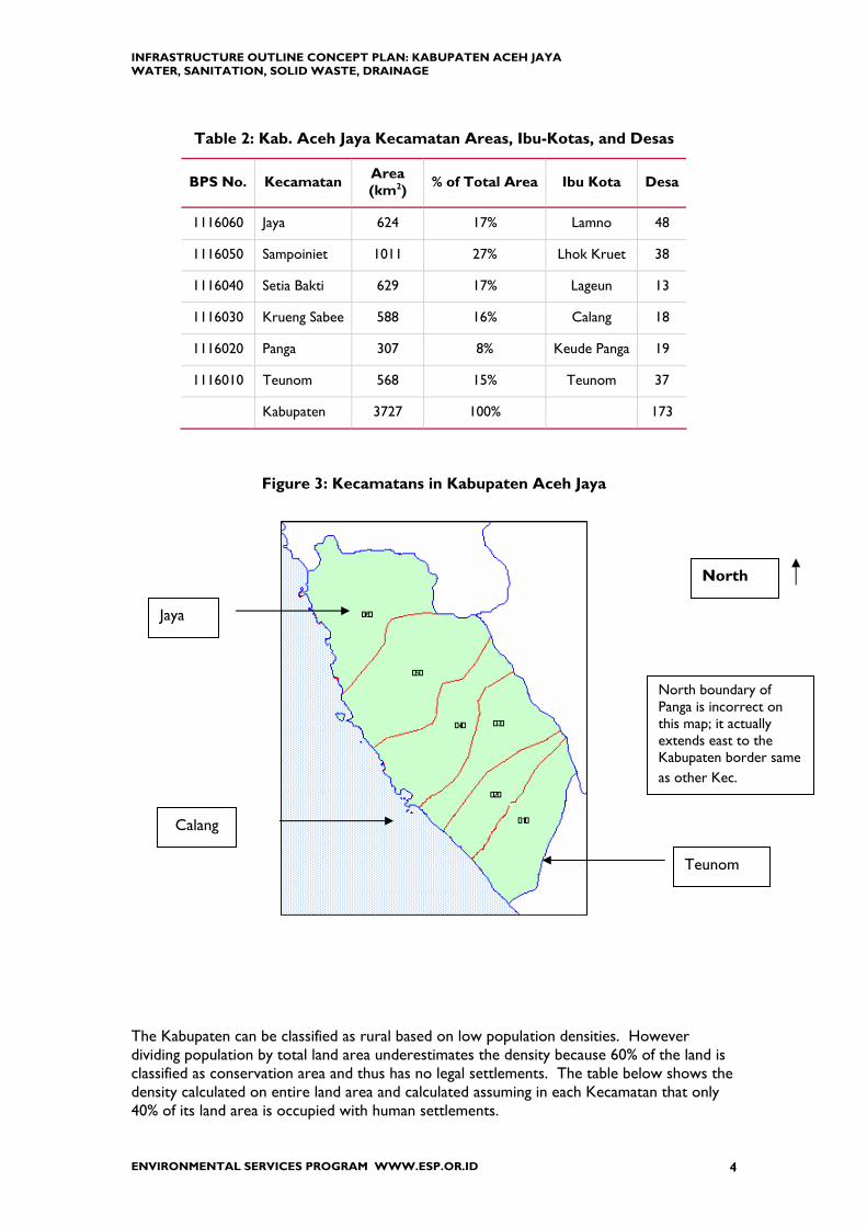
Table 2: Kab. Aceh Jaya Kecamatan Areas, Ibu-Kotas, and Desas
BPS No. Kecamatan Area (km2) % of Total Area Ibu Kota Desa
1116060 Jaya 624 17% Lamno 48
1116050 Sampoiniet 1011 27% Lhok Kruet 38
1116040 Setia Bakti 629 17% Lageun 13
1116030 Krueng Sabee 588 16% Calang 18
1116020 Panga 307 8% Keude Panga 19
1116010 Teunom 568 15% Teunom 37
Kabupaten 3727 100% 173
Figure 3: Kecamatans in Kabupaten Aceh Jaya
The Kabupaten can be classified as rural based on low population densities. However dividing population by total land area underestimates the density because 60% of the land is classified as conservation area and thus has no legal settlements. The table below shows the density calculated on entire land area and calculated assuming in each Kecamatan that only 40% of its land area is occupied with human settlements.
Jaya
North
Teunom
North boundary of Panga is incorrect on this map; it actually extends east to the Kabupaten border same as other Kec.
Calang

INFRASTRUCTURE OUTLINE CONCEPT PLAN: KABUPATEN ACEH JAYA WATER, SANITATION, SOLID WASTE, DRAINAGE
ENVIRONMENTAL SERVICES PROGRAM WWW.ESP.OR.ID 5
Table 3: Kab. Aceh Jaya Year 2005 Population and Density
[after earthquake and Tsunami]
BPS No. KecamatanLand Area
(km2)PopulationYear 2005
Density(people/km2)
Occupied Land (km2)
Density(people/km2)
1116060 Jaya 624 17,904 29 250 72
1116050 Sampoiniet 1011 10,685 11 400 27
1116040 Setia Bakti 629 5,767 9 250 23
1116030 Krueng Sabee 588 10,244 17 240 43
1116020 Panga 307 4,888 16 120 41
1116010 Teunom 568 14,051 25 230 61
Total 3,727 63,539 17 1,490 43
Source: Badan Pusat Statistic (BPS) Aceh Barat, 2004 and 2005 60% of land is conservation area

INFRASTRUCTURE OUTLINE CONCEPT PLAN: KABUPATEN ACEH JAYA WATER, SANITATION, SOLID WASTE, DRAINAGE
ENVIRONMENTAL SERVICES PROGRAM WWW.ESP.OR.ID 6
3. EARTHQUAKE AND TSUNAMI IMPACTS Government of Indonesia, Donors, and NGOs have stated their commitment to “Build Back Better” housing, schools, health facilities, and infrastructure. The purpose of this section of the report is to provide qualitative and quantitative data that can be used to establish a baseline for pre-earthquake and tsunami conditions. The earthquake and tsunami of 26 December 2004 affected the entire Kabupaten from coast line inland up to 6 kilometers. All six sub-districts of the Kabupaten were affected. 24% of the population is dead or missing; 90 of the 173 villages damaged; 60% of schools damaged; 90% of government offices destroyed; about 24% of government staff dead.
A. CONDITIONS BEFORE AND AFTER Prior to the tsunami, almost 90% of Aceh Jaya residents were farmers and fishermen, with the remainder being traders, civil servants and members of security agencies (TNI, POLRI). For Year 2002 about 70% of the Gross Regional Domestic Product for Aceh Jaya (total Rupiah 302 billion) was from Agriculture (Rp 216 billion). With much of the infrastructure, arable land and all fishing infrastructure ruined by the tsunami, the main sources of income have been destroyed. The following tables summarize data from BPS for 173 villages in the six kecamatan for water supply, sanitation, solid waste, and drainage.

INFRASTRUCTURE OUTLINE CONCEPT PLAN: KABUPATEN ACEH JAYA WATER, SANITATION, SOLID WASTE, DRAINAGE
ENVIRONMENTAL SERVICES PROGRAM WWW.ESP.OR.ID 7
Table 4: Year 2003 Infrastructure Services in Kab Aceh Jaya
Water Supply
PAM/or Mineral water 2 0 0 0 0 1 3
Pump 0 0 0 0 0 0 0
Well and Spring 43 29 13 9 17 35 146Others 3 9 0 9 2 1 24
Solid Waste
Transported to other place 2 2 0 0 0 1 5
Buried or Burned 28 31 9 11 18 23 120
Disposed to river 10 0 3 7 0 0 20
Other 8 5 1 0 1 13 28
Latrine
Private Latrine 2 2 0 4 1 8 17
Latrine for a group 1 0 1 0 0 2 4
Public Latrine 17 0 0 0 0 2 19
Others 28 36 12 14 18 25 133
Drainage/Sewer
Flowing normally 4 8 0 5 0 8 25
Bad condition 8 21 2 10 1 7 49
flooded 1 0 0 3 0 2 6No sewer 35 9 11 0 18 20 93
Kecamatan in Kabupaten Aceh Jaya
Sampoiniet Setia Bakti Krueng Sabee PangaWATSAN Condition
TotalTeunomJaya
Source: Badan Pusat Statistik (BPS) Provinsi Nanggroe Aceh Darussalam
Table 5: Details about Water Supply before 26 December 2004
Kecamatan Village Water Supply Teunom Teunom 5 L/s surface water treatment plant that was NOT operational due to
deterioration and neglect Panga Individual wells
Calang 20 L/s surface water treatment plant but not yet in service Krueng Sabee Paya
Seumanto 1 L/s deep well
Setia Bakti No information Lhok Kruet 2.5 L/s spring water; gravity system Sampoiniet Blang Dalam 1 L/s deep well
Lamno 5 L/s spring water, gravity system Jaya Janget 1 L/s deep well
Prior to the earthquake and tsunami it was possible to drive north and south on asphalt roads and bridges. For example from Calang north to Lamno took on average 1.5 hours on asphalt paved road with two-lane steel girder bridges. Now the same trip takes about 6 hours with delays at single-lane bridges, waiting for cars in front to get unstuck from deep, muddy ruts in the dirt road and at Krueng Lambesso with the bridge destroyed crossing the river by a ferry powered by two 40-Hp outboard motors and holding a maximum of four passenger vehicles. From Calang south to Teunom used to take one hour; but now two

INFRASTRUCTURE OUTLINE CONCEPT PLAN: KABUPATEN ACEH JAYA WATER, SANITATION, SOLID WASTE, DRAINAGE
ENVIRONMENTAL SERVICES PROGRAM WWW.ESP.OR.ID 8
hours with slow driving on rough, hard packed dirt road and delays at single-lane bridges. Before the earthquake and tsunami driving from Teunom to Meulaboh was a 1 to 2 hour trip but immediately after it took about 16 hours and today about 4 hours. PLN provided electricity before 26 December. With poles and electric lines knocked down people now use generators, bottled gas, kerosene, and candles.
B. INTERNALLY DISPLACED PERSONS About 19,000 people are classified as Internally Displaced Persons (IDP) and currently living in tents or barracks or with host families. In Calang individual NGOs have assumed responsibility for providing WATSAN services to Temporary Living Centers. Factors in assuring smooth operations1 are establishing a committee of barracks residents to handle day-to-day matters and to designate a specific individual as “Barracks Liaison”.
Table 6: Kab. Aceh Jaya IDP Status October 2005
BPS No. Kecamatan
Spontaneous Settlement
CampHost
CommunitiesTemporary
Living CenterEarly
Return Total1116060 Jaya1116050 Sampoiniet 899 832 1,7311116040 Setia Bakti 171 3,499 3,6701116030 Krueng Sabee 427 2,054 778 4,331 7,5901116020 Panga 27 1,919 1,9461116010 Teunom 436 197 3,578 4,211
6 863 3,348 778 14,159 19,148
not available
Source: UNIMIS
C. GOI-GAM CONFLICT The Kabupaten was impacted by the Free Aceh Movement (Gerakan Aceh Merdeka, GAM) who had been fighting for an independent homeland in Aceh since 1976. On 15 August 2005 the Government of Indonesia and GAM signed a peace Memorandum of Understanding (MOU). NGOs providing houses to people affected by earthquake and tsunami are sometimes asked to do same for former GAM. It has been reported that former GAM will be given Rupiah one million per month for the next several years. Thus presence of GAM in a small village can have large, positive economic benefits to that village.
1 Interview and site visit with Gazaly Malek, Program Manager for Canadian Red Cross, Calang

INFRASTRUCTURE OUTLINE CONCEPT PLAN: KABUPATEN ACEH JAYA WATER, SANITATION, SOLID WASTE, DRAINAGE
ENVIRONMENTAL SERVICES PROGRAM WWW.ESP.OR.ID 9
Finding Number 2: Earthquake & Tsunami Damage Extensive. Earthquake and Tsunami damaged areas in Kabupaten Aceh Jaya are in all six Kecamatans due their location on the west coast. Interior areas of the kecamatans have been impacted by influx of Internally Displaced People. Destruction of the north-south roadway has significantly limited movement of repair materials. Thus infrastructure improvements are going to be 100% replacement of damaged facilities and development of new facilities to support relocated and new communities.

INFRASTRUCTURE OUTLINE CONCEPT PLAN: KABUPATEN ACEH JAYA WATER, SANITATION, SOLID WASTE, DRAINAGE
ENVIRONMENTAL SERVICES PROGRAM WWW.ESP.OR.ID 10
4. GOVERNMENT INSTITUTIONS AND ACEH ADAT ORGANIZATIONS
Kabupaten Aceh Jaya was established in year 2002 from an area that was formerly part of Kabupaten Aceh Barat. Established Kabupaten offices stayed in Meulaboh so the Aceh Jaya District government has never been fully formed, for example there has never been a PDAM or Dinas Kebersihan.
D. ADAT ORGANIZATIONS Government refers to Central, Province, Kabupaten/Kota, Kecamatan, Desa and Kelurahan. This organizational structure is found throughout Indonesia. Community refers to groups of people and in Aceh Province the community is organized into Mukims and Gampongs which date back to the time when Aceh was an independent Kingdom. • Gampong is a legal community unit; is headed by the Keuchik; and constitutes the lowest
administration organization under the direct supervision of the Mukim. • Mukim is formed from several Gampongs; has boundaries and assets; is led by the Imeum
Mukim; and is directly under the supervision of the Kecamatan. The Mukim and Gampong have legal status and are considered to be key elements implementing a community-oriented and participatory rehabilitation and reconstruction program in Aceh Province. Kabupaten Aceh Jaya is organized into 6 Kecamatans which are further subdivided into 25 Mukim and 173 Gampong (Desa). In this report the term Desa is used because that is the term commonly used by agencies working in Aceh and in databases.
Finding Number 3 Working with the Mukim. According to NGOs working in the region, the Mukim has been helpful getting agreement and implementing projects. Thus the Mukim could be helpful in developing and implementing Public Awareness and Education campaigns that accompany infrastructure programs.

INFRASTRUCTURE OUTLINE CONCEPT PLAN: KABUPATEN ACEH JAYA WATER, SANITATION, SOLID WASTE, DRAINAGE
ENVIRONMENTAL SERVICES PROGRAM WWW.ESP.OR.ID 11
E. BADAN REHABILITASI DAN REKONSTRUKSI (BRR)
BRR was established by Government of Indonesia on April 16 2005, by Regulation in Lieu of a Law (Regulation / Perpu) No. 2/2005 issued by the President of the Republic of Indonesia with the Mission statement: “To restore livelihoods and strengthen communities in Aceh and Nias by designing and implementing a coordinated, community-driven reconstruction and development program with the highest professional standards.” BRR
• brings together project proposals; • facilitates local government and civil society bodies in implementation of
projects, capacity-building where needed • Monitors progress of on-budget and off-budget projects • does NOT execute or implement projects directly • does NOT direct donor or NGO activities
The BRR’s infrastructure program unit is tasked with the role of coordinating donor support, reviewing proposals, and prioritizing projects.
Figure 4: BRR Organization Chart
Management Services Center
DeputyInfrastructure
DeputyHousing
DeputyInstitutional & HR
Development
DeputyBusiness & Economic
Development
Regional Offices (7)
Chief Operations Officer of BRR
Director BRRSpecial Projects
Water and Sanitation sector is included under the Deputy for Infrastructure. Details about the organization below Deputy are currently under revision.

INFRASTRUCTURE OUTLINE CONCEPT PLAN: KABUPATEN ACEH JAYA WATER, SANITATION, SOLID WASTE, DRAINAGE
ENVIRONMENTAL SERVICES PROGRAM WWW.ESP.OR.ID 12
5. LEVEL OF SERVICE TARGETS
F. RESIDENTIAL HOUSING Reference: Humanitarian Information Center for Sumatra: HIC Shelter Data Pack – 30 July 2005 available from web site http://www.humanitarianinfo.org/sumatra/ This document contains Procedures for NGOs to follow informing local government agencies about their shelter project and Building Code Standards for design and construction of housing and provision of services (water, sanitation, electricity, etc.) that are based on Indonesian National Standards (SNI). It includes details about interior water supply piping and storage, wastewater disposal, and garbage disposal. These standards define the Level of Service government agencies should provide to residential housing for water supply, sanitation, and solid waste. HIC Shelter Pack 2.2.3 System of Clean Water Supply
• Obtained individually or collectively from Drinking Water Company (PAM), or well, or other sources
• Quantity: 60-250 liter/person/day
NOTE: This is too wide a range and will lead to over sizing infrastructure. For an individual house, GOI standards are on the order of 120 L/capita/day. For water production facilities it is appropriate to use a higher number to take into consideration the demand of commercial, social, and institutional users. That could be on the order of 50 L/cap/day.
• Duration: available continually. • Quality: meet the quality requirements for clean water and a drinking water
source shall comply with Regulation of Minister of Health of the Republic of Indonesia Number 416/ MENKES/PER/IX/ 1990 and Decision of Minister of Health of the RI Number 907/ MENKES/ VII/ 2002.
• Pipe: PVC, PE, GI, or copper; does not contain toxic substances • Service Connection (connection between customer and PDAM pipes):
a. diameter of pipe connection from city's distribution pipe network is established according to the type of building and activity therein;
b. should be equipped with water meter c. made of PVC, PE, GI, or other material which can resist water pressure d. provide sufficient quantity and pressure e. requires service connections to have back flow prevention valve or
vacuum breaker (many Indonesians are likely to consider this expensive and omit but it is particularly important where houses have alternate water sources such as a well due to risk of contaminating the public water supply).
INFRASTRUCTURE OUTLINE CONCEPT PLAN: KABUPATEN ACEH JAYA WATER, SANITATION, SOLID WASTE, DRAINAGE
ENVIRONMENTAL SERVICES PROGRAM WWW.ESP.OR.ID 13
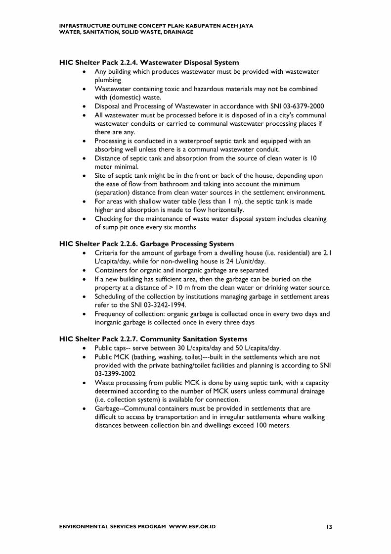
HIC Shelter Pack 2.2.4. Wastewater Disposal System • Any building which produces wastewater must be provided with wastewater
plumbing • Wastewater containing toxic and hazardous materials may not be combined
with (domestic) waste. • Disposal and Processing of Wastewater in accordance with SNI 03-6379-2000 • All wastewater must be processed before it is disposed of in a city's communal
wastewater conduits or carried to communal wastewater processing places if there are any.
• Processing is conducted in a waterproof septic tank and equipped with an absorbing well unless there is a communal wastewater conduit.
• Distance of septic tank and absorption from the source of clean water is 10 meter minimal.
• Site of septic tank might be in the front or back of the house, depending upon the ease of flow from bathroom and taking into account the minimum (separation) distance from clean water sources in the settlement environment.
• For areas with shallow water table (less than 1 m), the septic tank is made higher and absorption is made to flow horizontally.
• Checking for the maintenance of waste water disposal system includes cleaning of sump pit once every six months
HIC Shelter Pack 2.2.6. Garbage Processing System
• Criteria for the amount of garbage from a dwelling house (i.e. residential) are 2.1 L/capita/day, while for non-dwelling house is 24 L/unit/day.
• Containers for organic and inorganic garbage are separated • If a new building has sufficient area, then the garbage can be buried on the
property at a distance of > 10 m from the clean water or drinking water source. • Scheduling of the collection by institutions managing garbage in settlement areas
refer to the SNI 03-3242-1994. • Frequency of collection: organic garbage is collected once in every two days and
inorganic garbage is collected once in every three days HIC Shelter Pack 2.2.7. Community Sanitation Systems
• Public taps-- serve between 30 L/capita/day and 50 L/capita/day. • Public MCK (bathing, washing, toilet)---built in the settlements which are not
provided with the private bathing/toilet facilities and planning is according to SNI 03-2399-2002
• Waste processing from public MCK is done by using septic tank, with a capacity determined according to the number of MCK users unless communal drainage (i.e. collection system) is available for connection.
• Garbage--Communal containers must be provided in settlements that are difficult to access by transportation and in irregular settlements where walking distances between collection bin and dwellings exceed 100 meters.

INFRASTRUCTURE OUTLINE CONCEPT PLAN: KABUPATEN ACEH JAYA WATER, SANITATION, SOLID WASTE, DRAINAGE
ENVIRONMENTAL SERVICES PROGRAM WWW.ESP.OR.ID 14
G. LEVEL OF SERVICE COVERAGE BRR is setting Level of Service coverage for infrastructure services for reconstruction of settlements:
• Water supply system, transmission and distribution of clean water with the target to cover 80% of urban population 24 hours/day, 7 days/week, at pressure 7.5 meters2.
• Water supply system to serve 50% rural population by piped water systems with remaining 50% rural population easy access to water (e.g. Public Hydrant)
• Construction of drainage system to cover 100% urban population and 10% rural population
• Development of Solid Waste services (including sanitary land fill) to cover 100% urban and 10% rural population
There is no international definition for “urban” or “rural” population; each country has their own criterion that generally is based on density (number of people per square kilometer). Data from
2 BRR presentation at Banda Aceh-Aceh Besar WATSAN Meeting, 16 Jan 06.

INFRASTRUCTURE OUTLINE CONCEPT PLAN: KABUPATEN ACEH JAYA WATER, SANITATION, SOLID WASTE, DRAINAGE
ENVIRONMENTAL SERVICES PROGRAM WWW.ESP.OR.ID 15
Table 3 indicates that Kabupaten Aceh Jaya is predominantly rural. As discussed later in this report, there are “urban” concentrations around the Ibu Kota of each Kecamatan.

INFRASTRUCTURE OUTLINE CONCEPT PLAN: KABUPATEN ACEH JAYA WATER, SANITATION, SOLID WASTE, DRAINAGE
ENVIRONMENTAL SERVICES PROGRAM WWW.ESP.OR.ID 16
6. NGO AND DONOR ACTIVITIES: WATSAN AND SHELTER
H. GENERAL DISCUSSION Immediately after the earthquake and tsunami of 26 December 2004 foreign governments and relief agencies came to the region to provide emergency assistance that included water, food, temporary shelter, medical care, and supplies of clothing and other items. Tent camps and wooden barracks were established to provide temporary shelter for the Internally Displaced People (IDP). Water was delivered to these camps by tanker truck; septic tanks pumped, trash collected. During 2005 the Relief Stage transitioned to the Rehabilitation Stage. Non-Governmental Organizations (NGO)3 and donors such as USAID and World Bank are now organizing and financing construction of housing and rehabilitation of infrastructure such as roads, bridges, water supply, solid waste disposal, schools, hospitals, etc. The housing construction is at Desa level. Water supply is typically a bored well or a mountain spring piped to the settlement. Sanitation is the typical Indonesian septic tank (see Chapter 10 for details). NGOs are supposed to agree with the relevant government agency a Memorandum of Understanding (MOU) specifying what the NGO will do. This benefits Government by clearly defining the scope of work and the agency doing it, but some MOUs do not have timelines or deadlines to perform. Data about exact location and scope of NGO infrastructure activities is often incomplete and out-of-date. Reasons for this include:
• difficulties in submitting the data via the internet • confusion about exact location---the NGO knows where it is working but the
location may have more than one name or be on the border between two sub-districts.
• multiple NGOs in the same location because one or more NGOs are providing shelters while another NGO is providing WATSAN or two or more NGOs are in partnership for the same project
• NGOs that have not followed through on earlier promises • competition amongst NGOs.
BRR is responsible for coordinating efforts of NGOs and it is assisted by UNICEF, the donor community coordinator for water and sanitation. Coordination enables recognition of unmet needs or duplication of efforts. Previous efforts at coordination were not successful.
3 NGO is also referred to as Private Voluntary Organization (PVO) and Government organized NGO’s as GO-NoGO.

INFRASTRUCTURE OUTLINE CONCEPT PLAN: KABUPATEN ACEH JAYA WATER, SANITATION, SOLID WASTE, DRAINAGE
ENVIRONMENTAL SERVICES PROGRAM WWW.ESP.OR.ID 17
Now BRR’s main coordination tool is a fast-track project approval process in which every agency submits a Project Concept Note4 detailing the project’s plans, location of activities, budgets, and targets, which is then fed into a projects database, the “Recovery Aceh Nias Database”, called RAN, established end of October 2005 to track project approval and progress monitoring. Already there are complaints about difficulty of data input, so this database cannot be considered complete at this time. Donors and NGOs recognize coordination to be a collaborative task, not solely BRR’s responsibility, and that participation in meetings and forums is needed to inform others of their programs and activities. Thus UN coordinating agencies (e.g. UNICEF) organize and conduct meetings for NGOs to specifically discuss Shelter and WATSAN activities.
I. NGO AND DONOR ACTIVITIES IN KABUPATEN ACEH JAYA
There are 37 NGOs, 10 United Nations agencies and offices, and 5 International Donor organizations doing projects and providing services in Kabupaten Aceh Jaya. At least 24 have some involvement with infrastructure---shelter, water supply, and sanitation. Table 7 lists NGOs and Donors working in these sectors in the Kabupaten. An exact count of NGOs is not easy to do. For example
UNHCR is building housing and is negotiating with IRC to do rain water collection system for each house. IRC is negotiating with American Red Cross for funding. So each agency is going to report involvement in the same project.
Danish Red Cross, involved in livelihood projects in Teunom, intends to repair river embankments (drainage project) to protect farmland and houses. They are stating their intention not by BRR Concept Note but by Red Cross report forms. So this data may or may not be in the RAN data base system.
The United Nations established an Office of Recovery Coordinator in Calang last year. This office neither directs nor controls the NGOs; it serves as a central contact point; manages the NGO office-living area; and promotes coordination among the NGOs and between NGOs and the community. In January of this year BRR established the Aceh Jaya Regional Office in Calang. NGOs are taking the lead to develop water supply for the villages where they are providing housing. For example OXFAM hired an Indonesian Engineering Consultant to design the water system for Lamno; CARDI-IRC developed the water supply for Calang; Action Contre la Faime (ACF) and German Red Cross organized water for Teunom. As an example of coordination, NGOs in Calang propose to construct, equip, and staff a Water Quality Laboratory. Each NGO would contribute money or materials or staff. USAID through the Environmental Services Project (ESP) will contribute laboratory equipment, reagents, and initial training. To assure sustainability Aceh Jaya NGOs will arrange for an Indonesian agency, probably the local Health Department (Dinas Kesihatan) to operate the laboratory and will provide training and support for one year.
4 Letter Nomor 0021/BRR.3/I/2006 “Prosedur Partisipasi Pembangunan Sektor Air Bersih dan Sanitasi” from BRR dated 05 Jan 2006.

INFRASTRUCTURE OUTLINE CONCEPT PLAN: KABUPATEN ACEH JAYA WATER, SANITATION, SOLID WASTE, DRAINAGE
ENVIRONMENTAL SERVICES PROGRAM WWW.ESP.OR.ID 18
The following table lists NGOs reported to be doing Shelter and WATSAN activities in each Kecamatan of the Kabupaten.
Table 7: NGOs Doing Shelter, Water, & Sanitation in Kab. Aceh Jaya
NGO and DONOR in Kab. Aceh Jaya JAYA SAMPOINIET SETIA BAKTI KRUENG SABEE PANGA TEUNOM Total
Action Contre la Faime (ACF) Water & San Water & San Water & San Water & San 4
ADRA (temporary housing) Shelter 1Agency for Technical Cooperation and Development (ACTED) Water 1
American Red Cross Water & San Water & San Water & San Water & San Water & San 5
British Red Cross Shelter 1
CAM Water 1
Canadian Red Cross Shelter Shelter Shelter Shelter 4
CARITAS Czechia Shelter 1
German Red Cross Shelter Shelter & Water 2
Int. Disaster Emergency Service (IDES) Shelter 1
International Blue Crescent Shelter 1
International Medical Corps (IMC) Water & San Water & San 2International Rescue Committee (IRC) [sometimes referred to as CARDI-IRC] Water & San Water & San Water & San Water & San Water & San 5
MERLIN Water & San Water & San 2Obor Berkat Indonesia (OBI) with Habitat for Humanity Int. (HfHI) Shelter Shelter Shelter 3
OIKOS Portugal Shelter 1
Oman Charity Org (OCO) Shelter 1
OXFAM Shelter, Water, & San Shelter, Water, & San Water & San Shelter, Water, & San Water & San Water & San 6
Palang Merah Indonesia (PMI) Shelter, Water, & San 1
Samaritan's Purse Shelter 1
UNDP Shelter 1
UNHCR Shelter 1
West-South Humanitarian Relief Center Shelter, Water, & San Shelter, Water, & San 2
World Vision Shelter 1
24 8 10 9 8 5 9 Donor activities in Kabupaten Aceh Jaya include: USAID is organizing rehabilitation of the Banda Aceh—Meulaboh Highway UNDP (Banda Aceh office) has offered assistance for siting, constructing, and operating
solid waste disposal sites (TPA). Asian Development Bank is funding the “Community Water Services and Health
Project” which includes Aceh Jaya. Focus is on rural communities. UNICEF will provide WATSAN facility at 45 temporary schools through agreements
with NGOs working in the area.

INFRASTRUCTURE OUTLINE CONCEPT PLAN: KABUPATEN ACEH JAYA WATER, SANITATION, SOLID WASTE, DRAINAGE
ENVIRONMENTAL SERVICES PROGRAM WWW.ESP.OR.ID 19
J. HOUSING (SHELTER) ACTIVITIES IN KABUPATEN ACEH JAYA
International Disaster Emergency Services (IDES) is constructing 430 “temporary homes” in Teunom [200 complete, 50 in progress] but have requests from Village leaders for 800. Red Cross organizations (British, Canadian, German, and Indonesian) are committed to building about 6,000 houses; the UN High Commissioner for Refugees (UNHCR) about 3,000; and Samaritan’s Purse about 900. This is about 70 % of the 14,000 estimated permanent homes needed in Aceh Jaya.
Table 8: Kab. Aceh Jaya Housing Status—Nov.05
HOUSING (as of Nov-05)
Kecamatan Needed MOU Not Committed
Jaya 3,250 1,661 49%
Sampoiniet 2,649 1,300 51%
Setia Bakti 1,950 400 79%
Krueng Sabee 1,460 1,025 30%
Panga 1,416 950 33%
Teunom 3,145 702 78%
6 13,870 6,038 7,832
56%
Finding Number 4: Future Demands from Current NGO Activities. NGO provided housing and water supply serves a useful humanitarian purpose but it creates a demand for public works services. Therefore Kabupaten and Kecamatan agencies need to plan now to assure sufficient qualified staff, equipment, and infrastructure to support this housing.

INFRASTRUCTURE OUTLINE CONCEPT PLAN: KABUPATEN ACEH JAYA WATER, SANITATION, SOLID WASTE, DRAINAGE
ENVIRONMENTAL SERVICES PROGRAM WWW.ESP.OR.ID 20
Other activities include: Asian Development Bank (ADB) is funding the “Community Water Services and Health
Project” which includes Aceh Jaya. Focus is on rural communities. Catholic Relief Services is repairing the existing Banda Aceh-Meulaboh Road from Lamno
to Calang and Japanese International Cooperation Services (JICS) from Calang to Meulaboh
International Organization for Migration (IOM) is building schools. UNDP (Banda Aceh office) has offered assistance for siting, constructing, and operating
solid waste disposal sites (TPA). USAID is organizing rehabilitation of the Banda Aceh—Meulaboh Highway World Health Organization (WHO) is reported to be donating a pumper truck to de-
sludge septic tanks

INFRASTRUCTURE OUTLINE CONCEPT PLAN: KABUPATEN ACEH JAYA WATER, SANITATION, SOLID WASTE, DRAINAGE
ENVIRONMENTAL SERVICES PROGRAM WWW.ESP.OR.ID 21
7. EXPECTED DEVELOPMENT AND GROWTH With so much death and destruction, the major effort to date has been on recovery and temporary construction. The emphasis is to construct permanent housing with associated infrastructure (water supply, electricity, etc.); provide public services (education; health; religion); re-establish government facilities and services; develop economic and livelihood activities (e.g. fishing, agricultural, trade). There is currently no development plan for the entire Kabupaten5. A Spatial Plan for New Calang has been prepared6 that lists types and number of buildings, area (square meters), utility (electricity, water, sanitation) demands, roads, number of houses for the period 2009 to 2015. The new Calang (kota baru) is planned for a location about 4 kilometers inland from existing and at a higher elevation. The Report discusses locations elsewhere in the Kabupaten and recommends new IbuKotas for 5 of the 6 Kecamatans. The harbor in Calang is being rebuilt and enlarged to accommodate delivery of construction materials. It would be designated as a Regional Port in accordance with Government of Indonesia Ministry of Transportation Guidelines. There has been discussion about establishing an ice plant in Calang to be used to preserve fish for shipment. This would reduce reliance on Meulaboh and enable direct shipments of fish. USAID has signed a Memorandum of Understanding (MOU) with GOI Ministry of Public Works (MPW) to reconstruct the road between Banda Aceh and Meulaboh (240 kilometers) to ASEAN Highway Standards (7 meter carriage-way with 2 meter shoulders).
Table 9: Banda Aceh-Meulaboh Road Specifications
Length 240 km Lanes 2 Pavement Width 7 m Shoulders 2 to 2.5 m Width of Right-of-Way 30 m
Construction is estimated at 4 years in two phases. Phase 1 will rehabilitate existing road between Banda Aceh to Lamno (80 km). Phase 2 will extend the road from Lamno to Meulaboh (about 160 km) along a new alignment. In the meantime, Japanese International Cooperation Services (JICS) is rehabilitating the existing road from Calang to Meulaboh (115 km) and Catholic Relief Services (CRS) from Lamno to Calang. The exact alignment of the Banda Aceh-Meulaboh Road is not yet settled. According to the Environmental Assessment Report7 the preferred alternative utilizes most of the original roadway up to Lhok Kruet (Kec. Sampoiniet) at which point a new roadway alignment will
5 Interview with Bpk Chairul Anwar, Kabid Perencanan, Kab. Aceh Jaya, 081-516352505 6 Rencana Rihei Tata Ruang Kawasan Kota Calang, prepared by PT. Ciriatama Nusawidya Consult, December 2005. 7 Environmental Assessment for Proposed Phase II-Banda Aceh to Meulaboh Road Reconstruction and Rehabilitation, US Army Corps of Engineers, Honolulu Eng. Dist. Nov05.

INFRASTRUCTURE OUTLINE CONCEPT PLAN: KABUPATEN ACEH JAYA WATER, SANITATION, SOLID WASTE, DRAINAGE
ENVIRONMENTAL SERVICES PROGRAM WWW.ESP.OR.ID 22
be created that is further east from the coast, i.e. inland toward the mountains. Thus there will have to be several west-east roads connecting the coast to the BA-M Road. Design for the road is being done in the USA and there seems to be reluctance to state the exact alignment because early announcement can make land acquisition more expensive and time consuming. Unfortunately uncertainty about status of the road and lack of visual progress adds to the uncertainty as to how the Kabupaten will develop. Based on development elsewhere in Indonesia and on government announced plans for the Kabupaten, it seems reasonable to assume that:
• Most IDPs are living in their native Kecamatan and will want to return to their original villages as soon as shelter is available.
• The majority of population—70% to 80%---is likely to be living and working within 5
to 10 kilometers of the coast and along both the old and the new Banda Aceh—Meulaboh Highway.
• The primary employment of people will continue to be fishing and agriculture. Thus
trade through the ports and local markets will be important. So there is a need for east-west roads between the Highway and the coast to connect to the ports and to move commodities and supplies such as fish and crops.
• Calang will have a large day-time population with people coming to it because of the
Kabupaten Offices and the Port.
• Each Kecamatan will develop independently from the others in terms of economy and infrastructure.
• In the medium term (5-years), infrastructure such as water supply and sanitation will
develop on a village or town basis.
Figure 5: Distances between Kecamatan Capitals (IKK)
IKK Lamno Lhok Kruet Lageun Calang Keude Panga Teunom23 34 18 22 12
NORTH SOUTH

INFRASTRUCTURE OUTLINE CONCEPT PLAN: KABUPATEN ACEH JAYA WATER, SANITATION, SOLID WASTE, DRAINAGE
ENVIRONMENTAL SERVICES PROGRAM WWW.ESP.OR.ID 23
8. POPULATION PROJECTIONS Year 2005 population data was obtained from the Kabupaten.
Table 10: Kab. Aceh Jaya Population for Year 2005
BPS No. Kecamatanpre-
tsunamiYr. 2005
post-tsunami died
1116060 Jaya 24,279 17,904 26%
1116050 Sampoiniet 13,835 10,685 23%
1116040 Setia Bakti 6,903 5,767 16%
1116030 Krueng Sabee 14,662 10,244 30%
1116020 Panga 6,772 4,888 28%
1116010 Teunom 17,163 14,051 18%
83,614 63,539 20,075 To estimate the population growth rate population statistics were obtained from historic records for Kabupaten Aceh Barat, from which Kabupaten Aceh Jaya was formed. The table shows that the average population growth over the last 14 years has been approximately two percent per year. The average growth rate for the three years immediately preceding the Tsunami was 2.8%.
Table 11: Kecamatan Historical Population Data
Kecamatan Year Jaya Sampoi-
niet Setia Bakti
Krueng Sabee
Panga Teunom Total % Change
1991 74,272 1992 76,382 +2.8% 1993 79,223 +3.7% 1994 80,141 +1.2% 1995 81,797 +2.1% 1996 82,656 +1.1% 1997 22,220 17,236 10,428 13,748 6,459 21,054 91,145 +10.3% 1998 22,239 17,236 10,355 14,270 6,501 21,189 91,790 +0.7% 1999 22,002 17,178 9,833 14,294 6,564 21,060 90,931 -0.9% 2000 23,015 13,401 7,883 13,895 7,391 21,016 86,601 -5.0% 2001 23,048 13,258 7,978 13,802 7,389 21,007 86,482 -0.1% 2002 23,472 13,532 8,059 14,106 7,514 21,553 88,236 +2.0% 2003 24,903 14,478 8,691 15,007 7,981 22,804 93,864 +6.4% 2004 24,900 14,500 8,700 15,000 8,000 22,800 93,900 +0.0%
Average +1.9% Source: Historic records for Kab. Aceh Barat and Badan Pusat Statistic (BPS), 2004

INFRASTRUCTURE OUTLINE CONCEPT PLAN: KABUPATEN ACEH JAYA WATER, SANITATION, SOLID WASTE, DRAINAGE
ENVIRONMENTAL SERVICES PROGRAM WWW.ESP.OR.ID 24
Fluctuations in annual growth rate were mainly caused by moving transmigrants both in- and out of the area. Applying the average growth rate of 2% at rate to Kabupaten Aceh Jaya gives the following results, indicated by formula below and shown in Table 12
Population Year 2010 = (Pop. Year2005) x (1 + 2%)5
Table 12: Projected Population for Kab. Aceh Jaya
BPS No. Kecematan Yr. 2005 Yr. 2006 Yr. 2007 Yr. 2008 Yr. 2009 Yr. 2010
1116060 Jaya 17,904
18,262
18,627
19,000
19,380
19,767
1116050 Sampoiniet 10,685
10,899
11,117
11,339
11,566
11,797
1116040 Setia Bakti 5,767
5,882
6,000
6,120
6,242
6,367
1116030 Krueng Sabee
10,244
10,449
10,658
10,871
11,088
11,310
1116020 Panga 4,888
4,986
5,085
5,187
5,291
5,397
1116010 Teunom 14,051
14,332
14,619
14,911
15,209
15,513
63,539 64,810 66,106 67,428 68,777 70,152 source: Year 2005 Badan Statistic, Kab. Aceh Barat
Finding Number 5: Forecast Population for Kecamatans. Forecasting population based on total District population is useful when the District is a Kotamadya. However for a District such as Kabupaten Aceh Jaya populations are forecast for each Kecamatan because WATSAN infrastructure services will be organized and provided at Kecamatan and Desa level.

INFRASTRUCTURE OUTLINE CONCEPT PLAN: KABUPATEN ACEH JAYA WATER, SANITATION, SOLID WASTE, DRAINAGE
ENVIRONMENTAL SERVICES PROGRAM WWW.ESP.OR.ID 25
9. WATER INFRASTRUCTURE, SOURCES AND DEMAND
K. CURRENT SITUATION Kabupaten Aceh Jaya has never had a PDAM. There were IKK systems in Lamno Calang, and Teunom before the earthquake and tsunami. See Table 5 for details. Following is a partial list of water supply schemes in progress. Kecamatan Jaya In Lamno, OXFAM provided emergency water supply and is funding design of a permanent system. OXFAM activities in water supply include:
Mon Janeng reticulated water system was in operation. The system employs a reservoir to collect water from the Mon Janeng spring. The water is then pumped through a tank for treatment into 10 public tap stands. The network reaches 597 people in 3 villages.
Desa Mukhan (257 people) are served from the reticulated water system in the area, which supplies water from a borehole, through a tank to 7 public tap stands in Mukhan.
Cleaning and rehabilitating existing wells (367 up to June 2005) Kecamatan Sampoiniet and Kecamatan Setia Bakti OXFAM provides bore holes and water trucking and storage. Other NGOs assisted rehabilitating the spring water, gravity flow system for Lhok Kruet and for villages in Setia Bakti. MERLIN is organizing Village Water Committees in Setia Bakti and providing public education and hygiene training. Calang IRC-Cardi rehabilitated the existing spring to provide water. OXFAM has installed pipes and filters for water supply from a waterfall; dug three boreholes; cleaned over one hundred wells and provided water trucks and storage. Thus about 4,000 to 6,000 people in Calang have water supply. At Ketapang Barracks (TLC with 400 IDPs) IRC installed a water tap from a nearby spring that is filtered via a springbox into a holding tank capacity 45,000 liters8. Kecamatan Krueng Sabee Emergency water supply was provided by Thames Jaya and operated by IRC-Cardi. The system (pressure filter treatment) has been moved to another area since OXFAM-IRC began a piped water supply system from a spring source. Kecamatan Panga 8 IRC Aceh Newsletter, November 2005

INFRASTRUCTURE OUTLINE CONCEPT PLAN: KABUPATEN ACEH JAYA WATER, SANITATION, SOLID WASTE, DRAINAGE
ENVIRONMENTAL SERVICES PROGRAM WWW.ESP.OR.ID 26
Action Contre la Faim (ACF) has organized water trucking with total volume water deliver 20 m3 per day while IRC-Cardi provide a borehole complete with a pump, electrical generator and elevated tank to serve a group of tents in Kuta Tuha village. Samaritan’s Purse has cleaned and rehabilitated wells in Panga. Kecamatan Teunom In Teunom German Red Cross (GRC) installed a mini water treatment plant that produces 40 m3 per day (8 hours a day). Half of the water produced is delivered to Teunom through GRC trucking and the other 20 m3 goes to Panga through ACF water trucking. The mini plant treats raw water from Krueng Teunom and produces a treated water of good clarity.
Figure 6: Sketch of German Red Cross Water System in Teunom Dug Wells In much of Aceh Jaya the principal water sources are dug wells for drinking and either wells or surface water for washing and bathing. The typical well is hand excavated, about 1 meter diameter with a lining of pre-cast concrete rings or brick masonry; with a surrounding wall about 0.8 meter high at the top of the well together with posts, rail, pulley, and bucket and rope system for withdrawing water. There is sometimes a concrete slab constructed around the well (“apron”). Typical depths are 2 to 5 meters with seasonal fluctuations in water availability, most likely due to the annual rainfall pattern. Water from the wells varies in quality. In many areas there is a salty taste restricting usage to bathing and cleaning. At other locations the water shows high turbidity. The primary sustainability issue for dug wells is the lack of routine maintenance, particularly upkeep of the well surround, (“apron”), and attention to drainage in the immediate area. Cracking of the well surround can have an adverse effect on the quality of well water because it allows dirt and other wastes to enter the well. Proper drainage is important to maintain a clean and attractive environment around the well and to keep dirty water from
Kr. Teunom
Water rubber bag
Coagulation, Flocculation, Sedimentation
Filter
RW Pump
Water Truck

INFRASTRUCTURE OUTLINE CONCEPT PLAN: KABUPATEN ACEH JAYA WATER, SANITATION, SOLID WASTE, DRAINAGE
ENVIRONMENTAL SERVICES PROGRAM WWW.ESP.OR.ID 27
penetrating cracks. The routine maintenance costs of dug wells are small; and the work not technically difficult and within the existing capacity of most recipients to undertake.
L. WATER QUALITY Kabupaten Aceh Jaya has rivers, springs, and ground water that can serve as water sources. The advantages of springs as water sources are gravity flow and water quality is usually better than rivers however the disadvantage is uncertain reliability of flow particularly during the dry season. Large rivers in the Kabupaten include Kr. Lambesso (Kec. Jaya); Kr. Sabee (Kec. Krueng Sabee); Kr. Panga (Kec. Panga); and Kr. Teunom (Kec. Teunom). All are reported to have adequate year-round flow. But close to the ocean the river elevation is low and thus affected by the ocean tides, particularly during the dry season when volume of river flow is reduced. It is likely suitable locations for water out-takes are on the order of one or two kilometers from the ocean. The procedure for actual siting consists of measuring salinity during high tide periods and graphing results (concentration vs. distance from ocean). Flow in the rivers increases after rainfall but so also does the turbidity due to soil erosion. Thus river water needs some treatment before distribution to municipal customers. In the coastal areas groundwater can be brackish to saline and was adversely impacted by the tsunami (contaminated with salt water and human wastes). Among the first actions of GOI and NGOs was to clean these wells. However one cleaning is not sufficient and there are reports of salty water in these wells. In locations such as Kecamatan Panga individuals are digging shallow wells two to five meters deep but similar to cleaned wells there are reports of salty tasting water. The following table lists field measurements for pH and salinity made during a site selection assessment by staff from ESP-Aceh. Measurements for Krueng Lambesso and Krueng Kuala Ligan were at locations close to the ocean.

INFRASTRUCTURE OUTLINE CONCEPT PLAN: KABUPATEN ACEH JAYA WATER, SANITATION, SOLID WASTE, DRAINAGE
ENVIRONMENTAL SERVICES PROGRAM WWW.ESP.OR.ID 28
Table 13: pH and Salinity at Locations Close to the Ocean
Kabupaten Aceh Jaya Date
Kecamatan Desa Source pHSalinity(ppm)
Jaya Alue Mie Kr. Lambesso 7.9 high
Ujong Muloh Kr. Lambesso 7.9 high
Sampoiniet Lho Kruet shallow well 5 0.09
Sampoiniet Lho Kruet shallow well #1 4.2 0.06
Sampoiniet Lho Kruet shallow well #2 5.9 0.03
Sampoiniet Lho Kruet shallow well #3 6.7 0.06
Sampoiniet Kuala Ligan Kr. Kuala Ligan 7.8 3.62
Setia Bakti Lageun spring #1 6.8 0.19
Setia Bakti Lageun spring #2 4.3 0.13
Setia Bakti Lageun spring #3 7.2 0.17
Setia Bakti Lageun spring #4 6.8 0.13
Setia Bakti Lhok Timon spring 8 0.69
Krueng Sabee Keude Kr. Sabee spring 8.4 0.63
Krueng Sabee Mon Mata shallow well 7.6 1.2
Krueng Sabee Kuala Meurisi shallow well 7.5 0.69
Panga Keude Panga shallow well 6.3 3.66data from ESP-Aceh Watershed Team
mid-January 2006
Presence of arsenic in groundwater is mentioned by various international WATSAN and Health specialists, but none can say where or when. If only a rumor it needs to be quashed; if fact it needs to be publicized.
Finding Number 6: Aceh Jaya Water Quality Data. NGOs in Aceh Jaya analyze water quality for systems they install. Collecting and organizing this data is a quick, inexpensive approach to creating a reference database of Aceh Jaya water quality.
Finding Number 7: Arsenic in the Water. Is there arsenic in the water in Aceh? If data exists it needs to be confirmed, then publicly announced, prominently posted, and readily accessible. If there are questions or doubts, then organize a specific study with appropriate quality assurance and quality control for sample collection, transport, and analysis in order to convert rumor to fact.
INFRASTRUCTURE OUTLINE CONCEPT PLAN: KABUPATEN ACEH JAYA WATER, SANITATION, SOLID WASTE, DRAINAGE
ENVIRONMENTAL SERVICES PROGRAM WWW.ESP.OR.ID 29
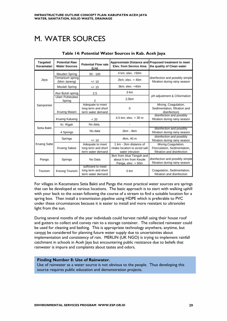
M. WATER SOURCES
Table 14: Potential Water Sources in Kab. Aceh Jaya
Meuden Spring 50 - 100 4 km; elev. +50mTemareum spring
(Mon Janeng) +/- 10 2km; elev. + 40m
Meulah Spring +/- 15 3km; elev. +40m
Alur Buluh spring 2.5 3 kmUlam Puhteubee
Spring 2 2,5km
Krueng Masen
Adequate to meet long term and short term water demand
0Mixing, Coagulation,
Sedimentation, filtration and disinfection)
Krueng Kalueng < 20 4.5 km; elev. + 30 mdisinfection and possibly
filtration during rainy season
Kr. Rigah No data, -
4 Springs No data 2km - 4kmdisinfection and possibly
filtration during rainy season
Springs +/- 10 4km, 40 mdisinfection and possibly
filtration during rainy season
Krueng SabeeAdequate to meet
long term and short term water demand
1 km - 2km distance of intake location to avoid salt
water intrusion
Mixing,Coagulation, Flocculation, Sedimentation,
filtration and disinfection
Panga Springs No Data3km from Alue Tengoh and
about 6 km from Keude Panga, elev. + 50m
disinfection and possibly simple filtration during rainy season
Teunom Kreung Teunomsufficient to meet
long term and short term water demand
0 km Coagulation, Sedimentation, filtration and disinfection
disinfection and possibly simple filtration during rainy season
Potential Raw Water Sources Potential Flow rate
(L/s)
Approximate Distance and Elev. from Service Area
Proposed treatment to meet the quality of Clean water
Targeted Kecamatan
Sampoiniet
Jaya
pH adjustment & Chlorination
Setia Bakti
Krueng Sabe
For villages in Kecamatans Setia Bakti and Panga the most practical water sources are springs that can be developed at various locations. The basic approach is to start with walking uphill with your back to the ocean following the course of a stream to find a suitable location for a spring box. Then install a transmission pipeline using HDPE which is preferable to PVC under these circumstances because it is easier to install and more resistant to ultraviolet light from the sun. During several months of the year individuals could harvest rainfall using their house roof and gutters to collect and convey rain to a storage container. The collected rainwater could be used for cleaning and bathing. This is appropriate technology anywhere, anytime, but cannot be considered for planning future water supply due to uncertainties about implementation and consistency of rain. MERLIN (UK NGO) is trying to implement rainfall catchment in schools in Aceh Jaya but encountering public resistance due to beliefs that rainwater is impure and complaints about tastes and odors.
Finding Number 8: Use of Rainwater. Use of rainwater as a water source is not obvious to the people. Thus developing this source requires public education and demonstration projects.

INFRASTRUCTURE OUTLINE CONCEPT PLAN: KABUPATEN ACEH JAYA WATER, SANITATION, SOLID WASTE, DRAINAGE
ENVIRONMENTAL SERVICES PROGRAM WWW.ESP.OR.ID 30
N. ESTIMATED WATER DEMAND This section forecasts for each Kecamatan water demand for the period 2006 to 2010. As discussed below, there is too much uncertainty to project further than five years.
There is no quantitative definition of urban or rural population. As discussed in Section 7 in this report we assume 70% to 80% of the population will be within 5 to 10 kilometers of the coast. Applying these numbers to Year 2010 population results in population densities ranging from 20 to 140 capita/km2 . Based on the population densities we used either 100 L/c/d (for more rural Kecamatans) or 140 L/c/d (for more urban Kecamatans) to calculate water demand.
Methodology for Estimating Water Demand
1) For each Kecamatan estimate population by year from 2006 to 2010, a) Start with Year 2005 population b) Increase by natural growth rate (assume 1.5%)
2) Assume water demand per domestic customer
a) Start with 100 Liters per person per day (L/c/d) b) Add 20% for use by commercial, social, and institutional customers (low % because not
so many) c) Add 20% for water losses (because these will be new systems) d) Use 140 L/c/d NOTE: for Kab. Aceh Besar a value of 180 L/c/d was used based on PU guidelines for service area 10,000 to 100,000; more developed commercial and social accounts; older systems so higher water loss. The Master Plan for Kota Baru Calang assumed 150 L/c/d & surface coverage of 60%.
3) Assume Service Area Coverage
a) 75% of the Kecamatan Population is in the Ibu Kota b) Service area coverage in year 2008 = 50%; in year 2010 = 80%.
4) Calculate Water Demand
Population x Consumption x % Service Area Coverage

INFRASTRUCTURE OUTLINE CONCEPT PLAN: KABUPATEN ACEH JAYA WATER, SANITATION, SOLID WASTE, DRAINAGE
ENVIRONMENTAL SERVICES PROGRAM WWW.ESP.OR.ID 31
Table 15: Estimated Population Densities and Water Demand Used
population 70% 80%
from coast 10 km 5 km
Kecamatan Density A Density B Use L/c/d
Jaya 60 140 140
Sampoiniet 30 50 100
Setia Bakti 20 40 100
Krueng Sabee 40 80 140
Panga 40 80 140
Teunom 60 120 140
Year 2010 Population Density
Water demand was calculated according to assumptions for:
Population in the Service Area (75%) % Population Served (i.e. Service Area Coverage) Water Demand of either 100 L/c/d or 140 L/c/d
Table 16: Estimated Water Demand for Kab. Aceh Jaya
Kecamatan Year 2006 Year 2007 Year 2008 Year 2009 Year 2010
Jaya 7 7 11 12 19Sampoiniet 3 3 5 5 8Setia Bakti 2 2 3 3 4Krueng Sabee 4 4 7 7 11Panga 2 2 3 3 5Teunom 5 5 9 9 15Population in Service Area% Population Served 80%
75%
Water Demand (L/c/d)
30% 50%
WATER DEMAND (L/sec)
Lamno; Calang; Panga, TeunomSampoiniet, Setia Bakti
140100

INFRASTRUCTURE OUTLINE CONCEPT PLAN: KABUPATEN ACEH JAYA WATER, SANITATION, SOLID WASTE, DRAINAGE
ENVIRONMENTAL SERVICES PROGRAM WWW.ESP.OR.ID 32
Based on data in Table 15 and rounding up to the nearest 5 L/s, the following sizes for water supply are recommended
Table 17: Recommended Size of Water Supply for Kab. Aceh Jaya
RECOMMEND L/s
Kecamatan 2006-2007 2008-2010 Remarks
Jaya 10 20 For Lamno
Sampoiniet two @ 5 two @ 5 2 different locations
Setia Bakti 0 0 wells and springs
Krueng Sabee 10 15 for Calang
Panga 5 5 wells and springs
Teunom 10 15 For Core area
Population in Kecamatan Setia Bakti is too dispersed to justify construction of a centralized water supply point. A more cost effective approach is to develop several springs in the hills to the east. As will be discussed in the following section, villages in Sampoiniet are dispersed so only two centralized sources are recommended for development.
Figure 7: Graph of Water Demand by Kecamatan—Year 2010
Aceh Jaya Water Demand vs Availability Year 2010
0
5
10
15
20
25
Jaya Sampoiniet Setia Bakti KruengSabee
Panga Teunom
Kecamatan
Lite
rs P
er S
econ
d
Estimated Water DemandWater Available 2008-2010
The graph shows that installed capacity is close to estimated water demand so that if demand increases at a faster rate there is risk of water shortages. But NO action is recommended at this time because of the uncertainties in making these projections. These uncertainties include:
• Current population • Population Growth rate • Migration of IDP into and out of Kecamatan • Water Demand per person • Service Area Coverage

INFRASTRUCTURE OUTLINE CONCEPT PLAN: KABUPATEN ACEH JAYA WATER, SANITATION, SOLID WASTE, DRAINAGE
ENVIRONMENTAL SERVICES PROGRAM WWW.ESP.OR.ID 33
• Volume of Water Losses The best course of action is to accurately measure water production and consumption; make census measurements of population; track construction of new housing during 2006 and 2007; and then if necessary, readjust the water supply construction program.
O. WATER SYSTEM STRATEGY Use of Groundwater At the moment many people rely on shallow wells as their water source. Even with the development of piped water supply it is reasonable to assume people will continue to use water from these wells for cleaning and washing. This would have the effect of reducing water demand from the government provided water supply system. Gravity vs, Pumped Systems Operating costs for water supply systems include salaries, electricity, chemicals, and maintenance. Almost always operating costs are lower when the water source is a mountain river or spring because water from these sources flows by gravity (reducing electricity costs) and the water quality is high (reducing chemical costs). Water Treatment Plants River water sources generally require chemical treatment only during the wet season when rainfall runoff carries silt and soil into the rivers. Slow Sand Filters are adequate Bulk Water Meters: It is important to measure the volume of water entering the distribution system and to compare it to volume of water sold to identify water losses and water consumption patterns. Provision for bulk meter should be a requirement during design and construction of new transmission pipelines.
Finding Number 9: Uncertainties Forecasting Water Demand. Forecasting Water Demand depends on estimates of population growth, water consumption, and service area coverage. Overestimating results in excess construction and underutilized facilities; underestimating in unsatisfactory service due to water shortages. At the moment there are so many uncertainties in the factors used to estimate demand that a reasonable course of action is to improve data collection and re-evaluate water demand two years from now to determine what further increases in water production might be needed.
Finding Number 10: Sustainable Water Supply. Water supply systems requiring pumping and chemical treatment are unlikely to be financially sustainable in Aceh due to insufficient money collected from user payments. Thus, where possible, develop gravity systems and high quality water requiring minimal treatment.

INFRASTRUCTURE OUTLINE CONCEPT PLAN: KABUPATEN ACEH JAYA WATER, SANITATION, SOLID WASTE, DRAINAGE
ENVIRONMENTAL SERVICES PROGRAM WWW.ESP.OR.ID 34
Non-revenue water is defined as the difference between water produced and water sold. It results from physical losses (e.g. leaking pipes, overflowing reservoirs) and commercial losses (meters that do not work; unauthorized connections). Recovering non-revenue water improves the financial position of the water company but will not increase the quantity of water available unless physical losses from leaking or broken pipes are located and repaired. Water systems in Aceh Jaya will be new so leakage should be low. It is important to continuously monitor non-revenue water because it impacts costs. Thus the importance of bulk water meters. Pipe for Water Supply Transmission and Distribution The material used to make pipes---steel, plastic, cement---is based on application, water pressure, soil condition, cost, and availability. In Aceh Province two pipes commonly used for water supply transmission and distribution are High Density Poly Ethylene (HDPE)9 and Poly Vinyl Chloride (PVC). Advantages of HDPE compared to PVC are
• More flexible; bends easier; trees and other obstacles are more easily by-passed using PE-pipes.
• Longer operating life [rubber rings of PVC deteriorate causing joints to leak] • Less joints required for same length of pipe installed • Sections do not separate during earthquake • Stronger resistance to ultra-violet light so HDPE does not require protection from
the sun thus avoiding expense of constructing overhead cover during storage • Smaller diameters of HDPE pipes are delivered on rolls making handling easier • Not necessary to make prefabricated bends.
HDPE is more expensive than PVC because
(1) HDPE requires special equipment to make the fusion connection (“plastic weld”) (2) HDPE has thicker walls to achieve specifications for nominal pressure class.
Although these two factors increase cost, it is actually advantageous. For potable water pipelines fusion connection is superior to chemical welding that is typically used for PVC because chemicals in the solvent used to make the weld can leach into the water imparting tastes and odors. HDPE as a thicker walled piped is easier than PVC to handle, place, and maintain.
Table 18: Cost Comparison of HDPE and PVC Pipe
Rupiah per Meter to Supply and Install HDPE and PVC Pipe
Nominal (Interior) Diameter (DN)
250 300 350
Supply HDPE Class PE100- PN8 456,924 687,420 897,370
PVC Class S-12.5 323,652 504,681 675,542
% higher 29% 27% 25%
Install HDPE Class PE100- PN8 75,595 105,285 132,756
PVC Class S-12.5 46,226 55,471 64,715
9 HDPE is the common but out-dated name. Technical name is PE-100.

INFRASTRUCTURE OUTLINE CONCEPT PLAN: KABUPATEN ACEH JAYA WATER, SANITATION, SOLID WASTE, DRAINAGE
ENVIRONMENTAL SERVICES PROGRAM WWW.ESP.OR.ID 35
% higher 39% 47% 51%
Meters of pipe supplied and installed for 1 Million Rp
HDPE Class PE100- PN8 1.9 1.3 1.0
PVC Class S-12.5 2.7 1.8 1.4
Data from Ir. Sudigyo for Year 2005 for Jakarta
P. FUTURE WATER SUPPLY INFRASTRUCTURE Lamno (Kecamatan Jaya) The proposed service area for water supply is the town of Lamno, which consists of 7 villages, and 26 villages surrounding. Total area is 235 km2 and estimated year 2005 population is 12,700. The Consultant that OXFAM has hired to prepare the detailed engineering design estimates year 2010 water demand (domestic and non-domestic) to be 17 L/sec. and proposes the following water sources:
Spring in the mountain near Meudhen village (capacity 40 to 50 L/sec) for North Zone
Spring in the mountain (capacity 50 L/sec) for South Zone Stream water from the Teumareum Spring for Central Zone Two deep wells, each 5 L/sec, for Central West Zone.
Figure 8: Lamno Water Supply Scheme (by OXFAM)
Finding Number 11: Use of HDPE Pipe for Water Transmission Lines. PVC is preferred in Indonesia because it costs less than HDPE. This is false economy. Even though it is more expensive, HDPE is easier to install, is stronger, and lasts longer than PVC. Therefore HDPE should be used rather than PVC for transmission pipelines.
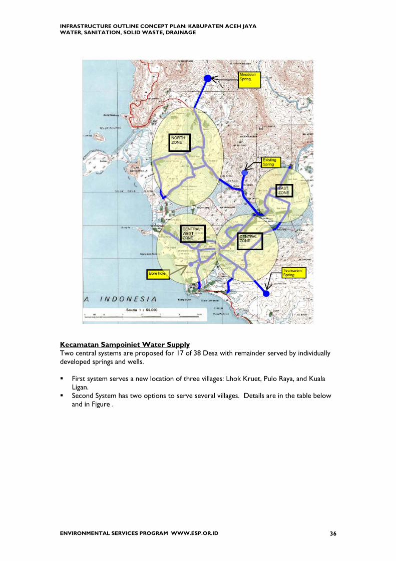
INFRASTRUCTURE OUTLINE CONCEPT PLAN: KABUPATEN ACEH JAYA WATER, SANITATION, SOLID WASTE, DRAINAGE
ENVIRONMENTAL SERVICES PROGRAM WWW.ESP.OR.ID 36
Kecamatan Sampoiniet Water Supply Two central systems are proposed for 17 of 38 Desa with remainder served by individually developed springs and wells. First system serves a new location of three villages: Lhok Kruet, Pulo Raya, and Kuala
Ligan. Second System has two options to serve several villages. Details are in the table below
and in Figure .

INFRASTRUCTURE OUTLINE CONCEPT PLAN: KABUPATEN ACEH JAYA WATER, SANITATION, SOLID WASTE, DRAINAGE
ENVIRONMENTAL SERVICES PROGRAM WWW.ESP.OR.ID 37
Table 19: Sampoiniet Water Supply Schemes
Sampoiniet Water Scheme---Option #1 Raw Water Source Krueng Kaleung Masen Water Fall WTP None Delivery System Gravity Transmission Pipe
(HDPE) 4500 m of diameter 150 mm 18000 m of diameter 100 mm Masen Semantok Babah Dua Ligan Gampong Baro Cot Pange Suak Bekah Rentang Krueng Tho Pajar Ujong Rimba Patek
Served Villages
Gunung Cut Blang Dalam Sampoiniet Water Scheme---Option #2
Raw Water Source Krueng Masen WTP Yes Delivery System Pumped Transmission Pipe
(HDPE) 50 m of diameter 150 mm 18000 m of diameter 100 mm 2500 m of diameter 75 mm
Served Villages Same as above but without Desa Masen The advantages of option #1 are gravity system and no chemical treatment. The advantage of option #2 is shorter transmission line because the water treatment plant is about 4.5 km closer to the villages being served.

INFRASTRUCTURE OUTLINE CONCEPT PLAN: KABUPATEN ACEH JAYA WATER, SANITATION, SOLID WASTE, DRAINAGE
ENVIRONMENTAL SERVICES PROGRAM WWW.ESP.OR.ID 38
Figure 9: Sampoiniet Water Supply Scheme
B.Aceh - Meulaboh Road
Good Road
Bad or Damage Road
Blang Dalam
New Patek
Pajar
Rentang Gampong
Baro L
Babah Ngom
Masen
Ujong Rimba
Suak Bekah
Krueng Tho
Cot Pange
Gunung Cut
Semantok
Ligan
Babah Dua
Sayeung
Alue Gajah
Cot Punti
Krueng Ayun
Ranto Sabun
Ie Jeu Reunge
Krueng Masen (River Masen)
Old Patek damaged)
Lageun
To Calang
From Lamno
Crak Mong
Meunasah Kulam
Alue Gro
Krueng No
WSP Option #1 Spring Water (Potential Cap. < 20 l/s) Gravity System
WSP Option #2 Krueng Masen - WTP Pumping System
New Location of Lhok Kruet, Pulo
Raya and Kuala Ligan spring
spring
Lhok Kruet
Kuala Ligan
Blang Meulun
Paya Santot
Arongan
Access Road (planned)
Pulo Raya
Babah Nipah
Mata Ie
Cot Langsat
Jeumpheuk
Water Fall Krueng Kaleung Masen Elev. +/- 30 m above msl
Kuala Bakung
Kampung B.P 100 mm HDPE/PVC
L = 8000 m
Ø150 mm HDPE/PVC L = 4500 m
100 mm HDPE/PVC L = 10000 m
100 mm HDPE/PVC L = 8000 m
100 mm HDPE/PVC L = 10000 m
New Lhok Kruet WSP Scheme
SAMPOINIET
SETIA BAKTI
JAYA
Kecamatan Boundary
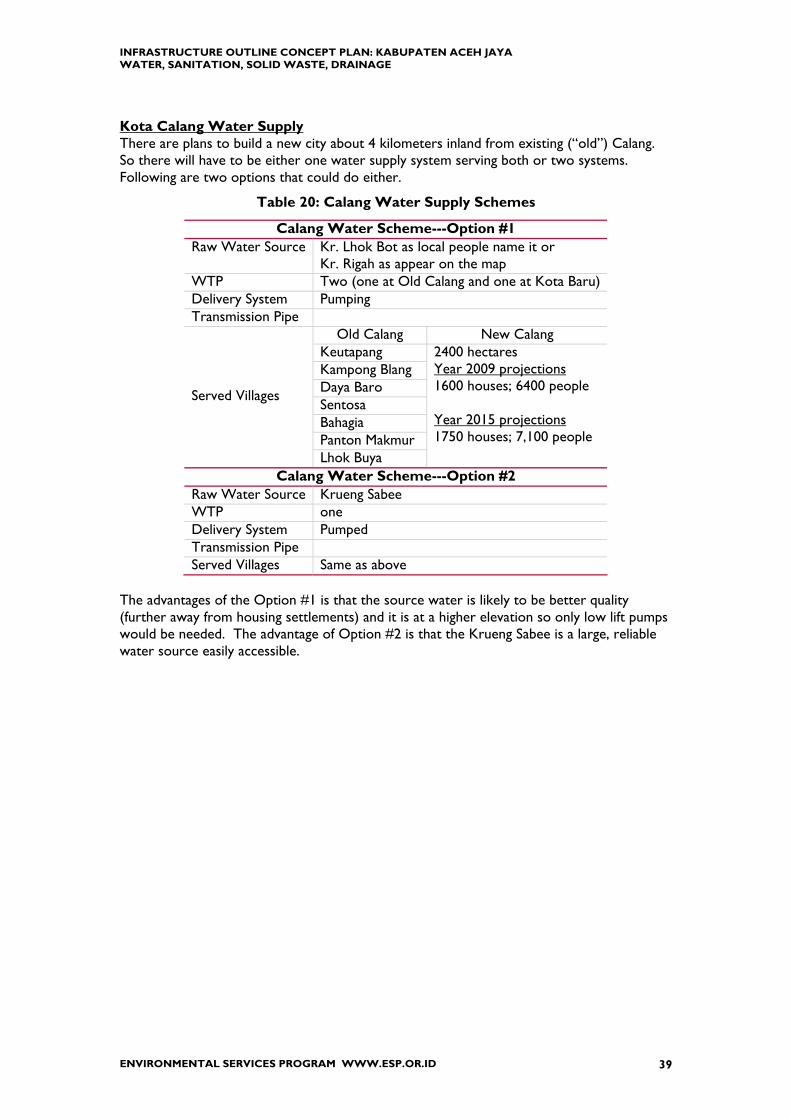
INFRASTRUCTURE OUTLINE CONCEPT PLAN: KABUPATEN ACEH JAYA WATER, SANITATION, SOLID WASTE, DRAINAGE
ENVIRONMENTAL SERVICES PROGRAM WWW.ESP.OR.ID 39
Kota Calang Water Supply There are plans to build a new city about 4 kilometers inland from existing (“old”) Calang. So there will have to be either one water supply system serving both or two systems. Following are two options that could do either.
Table 20: Calang Water Supply Schemes
Calang Water Scheme---Option #1 Raw Water Source Kr. Lhok Bot as local people name it or
Kr. Rigah as appear on the map WTP Two (one at Old Calang and one at Kota Baru) Delivery System Pumping Transmission Pipe
Old Calang New Calang Keutapang Kampong Blang Daya Baro Sentosa Bahagia Panton Makmur
Served Villages
Lhok Buya
2400 hectares Year 2009 projections 1600 houses; 6400 people Year 2015 projections 1750 houses; 7,100 people
Calang Water Scheme---Option #2 Raw Water Source Krueng Sabee WTP one Delivery System Pumped Transmission Pipe Served Villages Same as above
The advantages of the Option #1 is that the source water is likely to be better quality (further away from housing settlements) and it is at a higher elevation so only low lift pumps would be needed. The advantage of Option #2 is that the Krueng Sabee is a large, reliable water source easily accessible.

INFRASTRUCTURE OUTLINE CONCEPT PLAN: KABUPATEN ACEH JAYA WATER, SANITATION, SOLID WASTE, DRAINAGE
ENVIRONMENTAL SERVICES PROGRAM WWW.ESP.OR.ID 40
Figure 10: Calang Water Supply from Kr. Bot (Rigah)
Figure 11: Calang Water Supply from Kr. Sabee

INFRASTRUCTURE OUTLINE CONCEPT PLAN: KABUPATEN ACEH JAYA WATER, SANITATION, SOLID WASTE, DRAINAGE
ENVIRONMENTAL SERVICES PROGRAM WWW.ESP.OR.ID 41
Kecamatan Teunom Water Supply
Table 21: Teunom Water Supply Schemes
Teunom Water Supply Scheme Raw Water Source Krueng Teunom WTP one Delivery System Pumped Transmission Pipe
Same as above Simpang Ulim Padang Kleng Tano Anoue Keude Teunom Pasi Teubee
Served Villages
Alue AmbangPanton Pasi Tulak Bala
Figure 12: Teunom Water Supply
Teunom Service Area (Yellowed
Area)
Teunom WS System
WTP Location Option I
WTP Location Option II

INFRASTRUCTURE OUTLINE CONCEPT PLAN: KABUPATEN ACEH JAYA WATER, SANITATION, SOLID WASTE, DRAINAGE
ENVIRONMENTAL SERVICES PROGRAM WWW.ESP.OR.ID 42
Summary of Water Supply Capital Improvement Program Water Supply Systems for Lamno;17 villages in Samponiet; Calang; and Teunom Springs and wells for Individual homes and villages elsewhere
Table 22: Aceh Jaya Water Supply Schemes
Intake or Spring
Capturing WTP Reservoir Pumping Transmission Distribution Remarks
Jaya (Lamno) Spring Yes No Yes No Yes Yes Laboratory
Sampoiniet Spring Yes No Yes Yes Yes individual and village
¦ New Location of Lhok Kruet, Kuala Ligan, Pulo Raya
Spring Yes No Yes Yes Yes Yes
¦ Sampoiniet Villages alongBA-M Road
Spring Yes No No No Yes Yes
Setia Bakti Spring Yes No Yes No Yes Yes individual and village
Krueng Sabee Spring Yes No Yes No Yes Yes
Calang(new and old) River Yes Yes Yes Yes Yes Yes Laboratory
Panga Spring Yes No Yes No Yes Yes individual and village
Teunom River Yes Yes Yes Yes Yes Yes Laboratory
Capital Program Components
Area Source
OUTLINE PLAN FOR WATER SUPPLY Year 2006
Construct first stage of Lamno Water Supply Water Source investigations (quantity, quality) for Sampoiniet Water Schemes;
Calang, and Teunom Systems Field Investigations to locate suitable springs for Setia Bakti and Panga and
construction of at least one spring supply system in each to serve as model Organize Water Quality Database and publicize
Year 2007
Continue construction of Lamno Water Supply Detailed Engineering Design and Construction for Sampoiniet Water Schemes;
Calang, and Teunom Systems Continue installation of spring water supply systems to villages in Setia Bakti and
Panga Year 2008--2010
Evaluate current population and water demand data to determine when water supply systems should be expanded.
Expand water supply systems as needed Continue water quality database

INFRASTRUCTURE OUTLINE CONCEPT PLAN: KABUPATEN ACEH JAYA WATER, SANITATION, SOLID WASTE, DRAINAGE
ENVIRONMENTAL SERVICES PROGRAM WWW.ESP.OR.ID 43
10. SANITATION (HUMAN WASTE) INFRASTRUCTURE
This section is about the collection, treatment, and disposal of human wastes. Hazardous and Industrial wastewaters are not discussed.
Q. CURRENT SITUATION FOR DISPOSAL OF WASTEWATER
All sanitation in Aceh is on-site, mainly using septic tanks or pit latrines, both in urban and rural areas. For housing and commercial buildings human wastes (“black water”) go to a septic tank and water from sinks and baths (“grey water”) goes to the drainage system outside. It appears that the relevant GOI Ministerial Decree only specifies separation of these wastewaters; it does not exclude treatment for the grey water.
Figure 13: Excerpts from Decree of the Ministry of Settlements and Regional Infrastructure No. 534 / 2001
There are no organized wastewater collection or disposal systems in Kab. Aceh Jaya. NGO and Donor organizations responsible for TLC’s organize emptying of communal septic tanks at the camps. Disposal of truck contents is reported to be haphazard, mostly going into the ocean. Household Toilets and Septic Tanks The typical toilet is a pour flush squat plate of polypropylene or ceramic in a concrete plinth, with a discharge pipe to a pit or septic tank. The basic design includes a concrete “bak” to store water for flushing and cleansing. The siting of wells and toilets are subject to the NAD Building Coded which specifies specific separation distances (see Chapter 5.F. this report) to ensure that water wells were not contaminated by discharge from the septic tanks.
Guidance for minimum service standards on spatial planning, housing, settlement and public works (including waste water and sanitation):
• Grey water should be separated from black water • Black water should be discharged into a septic tank with no leaks or odors • There should be no contamination of ground water • Removal efficiencies for Biochemical Oxygen Demand (BOD) and Suspended Solids (SS)
> 85% • No complaint on septage treated in sludge treatment plant (IPLT)
On site sanitation should be provided where
• population density < 200 persons/hectare • with groundwater level > 2 meter • and potential cost recovery is not sufficient to support full sewerage system (e.g.
collection and centralized off-site treatment).

INFRASTRUCTURE OUTLINE CONCEPT PLAN: KABUPATEN ACEH JAYA WATER, SANITATION, SOLID WASTE, DRAINAGE
ENVIRONMENTAL SERVICES PROGRAM WWW.ESP.OR.ID 44
The typical septic tank consists of three concrete rings about 0.8 meter in diameter, 5 cm thick, and 0.3 meter high placed in the ground to form a circular chamber with unsealed bottom (i.e. open to the ground) and a concrete top that can be lifted. Cost of three rings and a top is about Rp 100,000. Installation can be done by unskilled labor. The open bottom allows liquid to pollute the shallow ground water with human wastes. This is a major problem in areas with high ground water. To keep wastes in the tank either a concrete bottom can be used to make the tank bottom water-tight. However the septic tank need to be filled with water to avoid it from floating with high groundwater. If PE liner sacks can be found in Aceh (or Jakarta) they can also be used when the tank is empty the bag floats on the ground water. As the tank fills, the bag sinks, keeping wastes inside. A better on-site septic system is the one used by the NGO Samaritan’s Purse in Kec. Panga, Kab. Aceh Jaya which consists of two tanks:
1) toilet waste enters the first tank which is about 1.5 meter deep (3 rings) with cement bottom, and exit line about 0.5 meter from top.
2) Second tank is about 0.5 meter deep (1 ring) with bottom of coconut or rock, ijuk (palm tree fiber), and charcoal.
Toilet waste flows into a tank with sealed bottom; solids stay in the first tank and liquid flows to a second tank. There it can be mixed with grey water before discharge to a sewer-drain. Samaritan’s Purse uses concrete rings 0.8 meter in diameter, 5 cm thick, and 0.5 meter in height. This is about 0.2 to 0.3 meters higher than rings commonly used in Kabupaten Aceh Besar and illustrates the misunderstanding that can occur when systems are specified or described according to “number of concrete rings”. Others are doing similar installations including OXFAM in houses it constructs and the USAID-ESP project for a wastewater pilot study it is conducting. A Community based piped wastewater collection system leading to a decentralized wastewater treatment plant is the preferred method in (peri-) urban areas because it is more economical than individual systems and provides better public health protection. Examples can be found in different locations in Indonesia, built by BORDA (Local NGO based in Yogyakarta) or in Kabupaten Bandung, another Indonesian NGO, Warga Peduli Lingkungan recently worked with local communities to install a piped wastewater collection system leading to a communal septic tank that discharges to a nearby river. Benefits include a significant reduction in the number of wastewater discharge points and some treatment of wastewater before discharge.
Finding Number 12: Sanitation Needs Improvement. Design and construction of sanitary wastewater collection, treatment, and disposal systems and the development and strengthening of utility institutions is a major unsatisfied need in the water supply environmental infrastructure sector. Resolving this requires Province and National support.

INFRASTRUCTURE OUTLINE CONCEPT PLAN: KABUPATEN ACEH JAYA WATER, SANITATION, SOLID WASTE, DRAINAGE
ENVIRONMENTAL SERVICES PROGRAM WWW.ESP.OR.ID 45
Figure 6: Typical Two Tanks Septic System
Inflow Black Water only
Overflow to the tank no 2
Tank no 2
Inflow grey water only
overflow to the sewer -drain
Tank no 1
Inflow from tank no 1
Gravel (kerikil)
Charcoal (arang)
Palm fiber (ijuk)
Ground surface
Tank no 2
Vent pipe

INFRASTRUCTURE OUTLINE CONCEPT PLAN: KABUPATEN ACEH JAYA WATER, SANITATION, SOLID WASTE, DRAINAGE
ENVIRONMENTAL SERVICES PROGRAM WWW.ESP.OR.ID 46
R. SEPTAGE COLLECTION AND TREATMENT Periodically septic tanks need emptying. Septage is the liquid and solid material pumped from a septic tank or cesspool when it is cleaned. Pumping is not always complete because the suction pump for sludge is not strong enough to empty the thick solids that accumulate at the bottom of a septic tank. The problem is worsened with the need to use long hoses to access septic tanks in housing areas with high density of buildings. Thick, stiff sludge at tank bottom needs to be mechanically stirred before it can be sucked up into the truck. This is difficult, dirty work so truck operators are not motivated to do it. Possible approaches to upgrading performance are: • train operators and provide protective equipment (gloves, boots, goggles) • inform the public the necessary steps for complete, effective tank cleaning10. The purpose of treatment is to “stabilize” the septage to reduce pathogens and odors, thus making it easier to handle and dispose. Methods for treatment and disposal of septage are:
1. land treatment and disposal 2. co-treatment at existing wastewater treatment facilities 3. independent facilities for treatment and disposal.
Land application is relatively simple, generally the most economic disposal technique, and utilizes the nutrient value of septage. It is useful for land that is damaged by mining or fire or otherwise impoverished of nutrients and vegetation. Three techniques of land disposal are (1) surface spreading, (2) burial, and (3) subsurface injection. Most of the organic and inorganic chemicals and pathogens remain in the upper 10 to 25 centimeters of soil. Land application can adversely impact ground and surface water. Typical guidelines are minimum distance to groundwater of 1 to 2 meters and minimum distance to surface water (lake, river, stream) of 100 meters. For surface spreading the truck goes to a designated location and dumps its load while driving to spread the septage into a thin layer on the ground. Sun, wind, and gravity will eventually remove the water, but it is best practice to mix the septage into the soil using for example the agricultural disc-harrow machine that farmers use to plough their fields. Assuming a truck with volume of 4 cubic meters spreading septage to thickness 5 cm, the area required would be 80 m2. Co-treatment of septage and wastewater can not now be done in Aceh because there are no wastewater treatment plants. When WWTP are built, provisions to receive septage should be included, i.e. a holding tank that allows a slow, continuous addition at a location upstream of the treatment plant headworks at a rate proportional to the plant inflow. Adding at this point enables the septage to pass through the grit removal system and to become diluted with wastewater influent as it enters. Common in Indonesia are IPLT (Instalasi Pengolahan Limbah Tinja). Septage is collected by a pumper truck, transported to the IPLT, and processed through a series of lagoons. Liquid effluent is discharged to a nearby water drainage channel and the thicker solids portion put onto sludge drying beds. After drying to a consistency where it can be moved by a shovel, the solids are removed and disposed. Drying time is a function of drainage and evaporation, and can range from 2 to 4 weeks. These solids can be applied to land. Typical components of IPLT are11: 10 Dominique Maison & Herlina Sjaifuddin, “Who Report Of Mission To Aceh Singkil”, Sep 05.

INFRASTRUCTURE OUTLINE CONCEPT PLAN: KABUPATEN ACEH JAYA WATER, SANITATION, SOLID WASTE, DRAINAGE
ENVIRONMENTAL SERVICES PROGRAM WWW.ESP.OR.ID 47
1. Entrance gate and driveway 2. Ramp and Platform (for the truck to empty the sludge) 3. Stabilization Ponds to reduce suspended solids and BOD 4. Sludge Drying Beds (to remove water from the sludge)
At the IPLT the liquid waste flows in sequence through three different types of ponds: anaerobic facultative maturation. Operating in series provides a larger removal of BOD and coliform reduction. Typical design: 1 anaerobic pond, 2 aerobic ponds (in parallel so one can be taken out of service for solids removal) and 2 maturation ponds (connected in series to get a better quality effluent).
Figure 7: Flow Scheme for IPLT Stabilization Ponds
FACULTATIVE POND
ANAEROBIC POND
MATURATION POND #1
MATURATION POND #2
FACULTATIVE POND
SAND DRYING BEDS
Maturation ponds in series are not necessary where the IPLT discharges directly to the ocean. Note that ocean discharge should be at a location that does not affect beaches or aquaculture but does get vigorous mixing from ocean currents.
S. FUTURE FACILITIES FOR SANITATION To calculate the size of a septic tank it is appropriate to use a value of 40 Liters/person/year faecal sludge12 production, but to determine the capacity of an IPLT a better approach is to estimate the volume of septic tanks emptied. The quantity of septage is calculated as follows:
Number of houses = (population / people per house) m3 / year septage = (houses x septic tank volume) Collected per week = (m3 / year) x (% houses with septic tanks) x (% emptied per
year) / working weeks per year Assumptions:
People per House 5 Septic Tank Volume (m3) 0.8 [0.8 m diameter, 1.5 m deep] % houses with septic tanks 80% % septic tanks emptied per year 50% working weeks per year = 50
Estimated quantities of septage for Year 2010 are shown in Table 23. 11 IPLT in West Java start with Imhoff Cone but it is not necessary. 12 World Health Organization (WHO) guideline is 100 L/capita/day for an adult weighing 70 kg and eating an average diet. Thus it is reasonable to assume 40 L/capita/day for Indonesia.
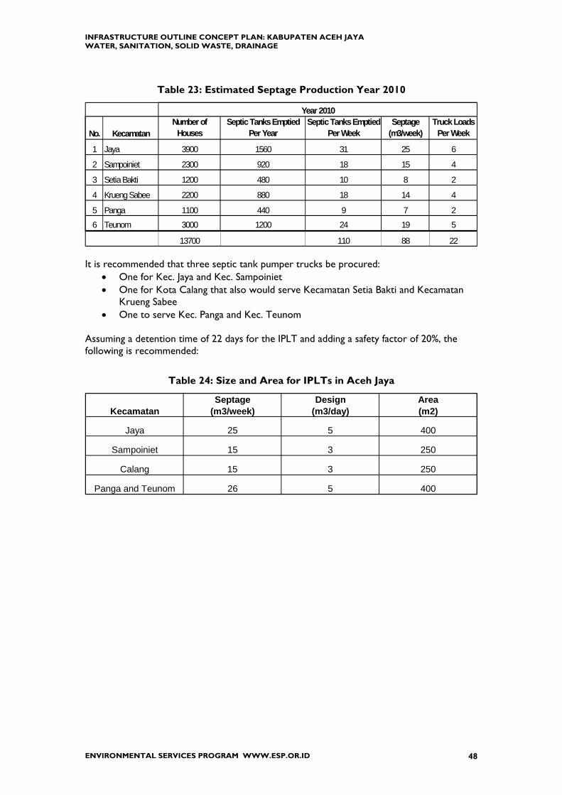
INFRASTRUCTURE OUTLINE CONCEPT PLAN: KABUPATEN ACEH JAYA WATER, SANITATION, SOLID WASTE, DRAINAGE
ENVIRONMENTAL SERVICES PROGRAM WWW.ESP.OR.ID 48
Table 23: Estimated Septage Production Year 2010
No. KecamatanNumber of
HousesSeptic Tanks Emptied
Per YearSeptic Tanks Emptied
Per WeekSeptage
(m3/week)Truck Loads
Per Week
1 Jaya 3900 1560 31 25 6
2 Sampoiniet 2300 920 18 15 4
3 Setia Bakti 1200 480 10 8 2
4 Krueng Sabee 2200 880 18 14 4
5 Panga 1100 440 9 7 2
6 Teunom 3000 1200 24 19 5
13700 110 88 22
Year 2010
It is recommended that three septic tank pumper trucks be procured:
• One for Kec. Jaya and Kec. Sampoiniet • One for Kota Calang that also would serve Kecamatan Setia Bakti and Kecamatan
Krueng Sabee • One to serve Kec. Panga and Kec. Teunom
Assuming a detention time of 22 days for the IPLT and adding a safety factor of 20%, the following is recommended:
Table 24: Size and Area for IPLTs in Aceh Jaya
KecamatanSeptage
(m3/week)Design
(m3/day)Area(m2)
Jaya 25 5 400
Sampoiniet 15 3 250
Calang 15 3 250
Panga and Teunom 26 5 400

INFRASTRUCTURE OUTLINE CONCEPT PLAN: KABUPATEN ACEH JAYA WATER, SANITATION, SOLID WASTE, DRAINAGE
ENVIRONMENTAL SERVICES PROGRAM WWW.ESP.OR.ID 49
Concept for Sanitation • Collect septage by septic tank pumper truck for treatment at IPLT • Co-locate IPLT with TPA • In rural areas try spreading on land
4 m3 spread 5 cm thick requires 80 m2 land mix into land using agricultural disc-harrow machine Major Concerns:
1) Contamination of water sources 2) Public acceptance of this disposal method
NGOs providing replacement housing are cognizant of WATSAN requirements and usually organize an adequate water supply but they are leaving sanitation to the usual practice. With construction of new and replacement housing, pollution and risk to public health will only get worse without action now to develop wastewater collection and disposal systems. Reconstruction of settlements is an opportunity to develop working sanitation systems that collect both grey and black water and provide adequate treatment and disposal in properly designed and functioning septic systems. For example where houses are close together it might be possible to install a wastewater collection system of PVC pipe to convey all wastewater---toilet, sink, and bath---to a properly13 built, multi-chamber septic tank that serves multiple houses. Solids can be pumped out periodically (1 to 2 years). Effluent can be further treated by constructed
13 By definition a septic tank holds the wastewater, provides treatment, discharges to a leaching field. The Indonesian version is not sealed thus allowing liquid to escape.
Outline Plan for Sanitation
Current Year (2006/2007) Procure three (3) septic tank pumper trucks and equipment: one for Kecamatans
Jaya and Sampoiniet; one for Kec. Panga and Teunom; and one for Kota Calang and surrounding area. Primary use at this time is for MCKs at TLCs.
Develop temporary disposal sites for septage [primary concern is to avoid contamination of ground water and surface water
Organize public education campaign about importance of sanitation collection and disposal and guidelines for constructing septic tanks
Locate suitable sites for septage treatment facilities with goal of co-locating septage and solid waste disposal sites
Construct MCKs at Pasars in each Kecamatan Conduct pilot projects for alternative treatment and disposal methods and
publicize results
Year 2007/2008 Design, construct, and put into operation IPLTs to serve Jaya, Calang, and
Teunom Test land disposal of septage in Kecamatans Sampoiniet and Setia Bakti Locate land that can use treated septage sludge from the IPLT
Year 2008—2010
Evaluate conditions and operations, then if necessary design, construct, and put into operation IPLTs to serve other areas in the Kabupaten

INFRASTRUCTURE OUTLINE CONCEPT PLAN: KABUPATEN ACEH JAYA WATER, SANITATION, SOLID WASTE, DRAINAGE
ENVIRONMENTAL SERVICES PROGRAM WWW.ESP.OR.ID 50
wetlands; used for landscape irrigation or certain types of agricultural crops; or discharged into the sea at a location with vigorous mixing. There are already some pilot projects investigating alternative collection and treatment methods, for example ESP-Aceh is developing a pilot project at Lham Kruet (Kec. Lhoknga) for several homes to use communal septic tanks with the liquid wastes disposal through a garden plantation. OXFAM is demonstrating an Australian system called Bioremediation Infield Personal Unit (BIPU). Long term these projects could lead to simpler and more effective residential wastewater collection and disposal. However in the short term, IPLT facilities should be planned and constructed.
INFRASTRUCTURE OUTLINE CONCEPT PLAN: KABUPATEN ACEH JAYA WATER, SANITATION, SOLID WASTE, DRAINAGE
ENVIRONMENTAL SERVICES PROGRAM WWW.ESP.OR.ID 51
11. SOLID WASTE INFRASTRUCTURE
T. CURRENT SITUATION FOR SOLID WASTE COLLECTION AND DISPOSAL
In Kab. Aceh Jaya each community manages its own solid waste collection and disposal. At the moment the Kabupaten DISPENDA (local income office) has been assigned responsibility for solid waste. UNDP Tsunami Recovery Waste Management Program (TRWMP) provides local governments with financial and technical support including:
• rehabilitation of landfill sites and provision of equipment; • organized recycling and reuse of tsunami debris; • demolition of damaged structures.
One of UNDP’s strategies is to provide interim disposal sites while a permanent, engineered disposal site is planned and constructed. Later the interim site would be cleared and rehabilitated. This strategy is applicable to Kab. Aceh Jaya. Collection is usually assigned to the community and neighborhoods, so that will not be considered further except for socialization and training.
COLLECTION TRANSFER (TPS) DISPOSAL (TPA)
Local Neighborhood Government Government
U. ESTIMATED SOLID WASTE PRODUCTION Solid waste production for year 2010 was estimated using
(a) population projections as shown in Table 12 (b) solid waste characteristics for Kota Banda Aceh
• 65% organic material, remainder inorganic • no construction debris (it is recycled or disposed in a separate location
exclusive for this type of waste) • initial density 200 to 300 kilograms per cubic meter (i.e. 0.2 to 0.3 kg/L)
before compaction (c) Government of Indonesia Standards [Metode, Spesifikasi Dan Tata Cara, Bagian: 11 Lalu Lintas, Lingkungan Jalan, Sanitasi dan Persampahan, Departemen Permukiman dan Prasarana Wilayah, Badan Penelitian dan Pengembangan, Jakarta, December 2002.]
Table 25: Solid Waste Production from Various Sources

INFRASTRUCTURE OUTLINE CONCEPT PLAN: KABUPATEN ACEH JAYA WATER, SANITATION, SOLID WASTE, DRAINAGE
ENVIRONMENTAL SERVICES PROGRAM WWW.ESP.OR.ID 52
SOURCE QUANTITY UNITS Residential House 2.5 Liter (L) per person per day
Market 0.2 L/square meter (m2) Commercial 2.5 Liters per Employee/Day
School 0.1 L/student/day Roads 0.1 L/lineal meter/day
Solid Waste (SW) from residential housing = Population x 2.5 L/person/day Assume area of market = 1m2 for 25 people and operates daily
Then SW from Market = (Population/25) x 0.2 L/m2 /day Assume 5% of population works in office or commercial business Then SW from Office/Commercial = (5% of Pop) x 2.5 L/day SW from roads = (length of road in meters) x 0.1 L/lineal meter/day Roads in Kabupaten for Year 2005 (per BPS):
145 km (Jl. Negara) + 35 (Jl. Propinsi) + 307 (Jl. Kabupaten) + 664 (Jl. Lingkungan) = 1152 km, [round up to nearest 100 km for calculation]
(1200 km road) x (0.1 L/Lineal Meter/Day) x (conversion factors) = 120 m3/day for the entire Kabupaten, which is negligible compared to SW from other sources Field verification is required to confirm data estimates. Solid waste accumulates so the landfill site must be sized to accommodate wastes generated over a period of several years.
Table 26: Solid Waste Production 2006--2010
TOTAL Area (ha)
Kecamatan 2006 2007 2008 2009 2010 2006 -10 2006 - 10Jaya 17,207 17,465 17,727 17,993 18,262 88,700 3.1Sampoiniet 10,269 10,423 10,579 10,738 10,899 52,900 1.9Setia Bakti 5,542 5,625 5,710 5,796 5,882 28,600 1.0Krueng Sabee 9,845 9,993 10,143 10,295 10,449 50,700 1.8Panga 4,698 4,768 4,840 4,912 4,986 24,200 0.8Teunom 13,504 13,706 13,912 14,120 14,332 69,600 2.4
11depth = 2m; compaction = 30%
Solid Waste Produced (m3)ANNUAL PRODUCTION
Three assumptions are made to estimate land area required:

INFRASTRUCTURE OUTLINE CONCEPT PLAN: KABUPATEN ACEH JAYA WATER, SANITATION, SOLID WASTE, DRAINAGE
ENVIRONMENTAL SERVICES PROGRAM WWW.ESP.OR.ID 53
1. All solid waste generated will be collected and transported to the landfill. In practice that does not happen---some blows away in the wind; is burned; recycled; lost at the transfer station; illegally dumped on the way to disposal site.
2. Solid waste placed in the landfill will be reduced 30% in volume from
evaporation, decomposition, and compression from the weight above it. If mechanical compression is provided, for example from bulldozer or compactor, then volume reduction would be greater and less land area required
3. Depth of solid waste landfill will be 2.0 meters. Greater depth means less land
required but larger size equipment is needed to excavate, place, and compact. The following table illustrates impacts of depth and compression assumptions.
Depth Compression Total Ha2.0 30% 113.0 30% 72.0 50% 83.0 50% 5
Impact of Assumptions
V. PRIVATE SECTOR PARTICIPATION IN SOLID WASTE SECTOR
Unlike sectors of water supply or sanitation, there is more opportunity for Private Sector Participation (PSP) in the solid Waste sector because it does not require specialized equipment or technical skills. Collection and transport of solid waste requires (1) a truck with a cover to prevent debris from falling or blowing out; (2) a destination (i.e. TPA). So contracting out these services can stimulate the economy, not burden government with vehicles and staff; and allow government to focus its efforts on operating and maintaining the TPA. There are two basic methods for Private Sector Participation in Solid Waste: • Under contract to a government agency to collect and transport residential and
commercial solid waste to a transfer station or disposal site. • Under contract to a private sector or institutional waste generator to collect and haul
waste to a waste disposal site. For example a hospital could contract with a private company to manage its health care wastes.
For transparency, contracting arrangements should be conducted through competitive bidding by contractors who are pre-qualified. To assure acceptable performance the contracting agency must follow up and evaluate.

INFRASTRUCTURE OUTLINE CONCEPT PLAN: KABUPATEN ACEH JAYA WATER, SANITATION, SOLID WASTE, DRAINAGE
ENVIRONMENTAL SERVICES PROGRAM WWW.ESP.OR.ID 54
W. STRATEGY FOR SOLID WASTE INFRASTRUCTURE
With assistance of UNDP and others, develop disposal sites for building debris from earthquake and tsunami In ground decomposition of tsunami debris (defined as concrete, brick, metal, wood, and construction rubble) is slow to none, so contamination of groundwater is small to nil. Metal can be recycled; wood burned for heat or cooking. Useful as fill material to raise ground level, make a barrier, cover trash in a landfill, foundation for road.
Establish disposal sites in each Kecamatan for domestic solid wastes. Start with “dig
and bury” sites at suitable locations
Establish TPS in each Kecamatan located at or close to the Pasar or other commercial center
Medical Waste disposed by on-site incinerator located near Hospital or other medical services such as Puskesmas or Clinic.
Each Kecamatan should have at least one Truck to collect solid wastes.
Provide Carts and Bins according to demand of services.
Implement Community Participation and Public Awareness campaigns for Source
Based Treatment (Separation, Recycling, and Household Composting)
X. FUTURE FACILITIES FOR SOLID WASTE COLLECTION AND DISPOSAL
11.1.1. TRANSFER SITES There are currently no sanitary landfills in Kab. Aceh Jaya. Solid waste is dumped and left to decompose or to be burned. Transfer Stations (TPS) have to be placed close to the area where solid wastes are generated. In Kecamatan the primary generation sources are markets (Pasars). A TPS is typically a container made from cement bricks with capacity 6 m3 – 12 m3. The operating lifetime of a TPS is 15 – 20 years. Delivery to the TPS is by individual container or cart and collection frequency is every 1 to 3 days, but preferably daily. Initially Transfer Stations should be located at Pasars (Markets) because this is an open area, centrally located, close to road network, and typically the largest single source of solid waste in the Kecamatan.

INFRASTRUCTURE OUTLINE CONCEPT PLAN: KABUPATEN ACEH JAYA WATER, SANITATION, SOLID WASTE, DRAINAGE
ENVIRONMENTAL SERVICES PROGRAM WWW.ESP.OR.ID 55
11.1.2. FINAL DISPOSAL SITES The Final Disposal Site (TPA) should be located14:
• Not in a flood prone area • Within distance of 20 to 30 kilometers (km) to Source or Transfer Station • At least 2 kilometers from Housing Areas • Down stream from water supply sources • At least one kilometer from rivers • At least three kilometers from airports • Slope < 20% • Capacity for 15 years of waste disposal • Entry/exit road not to pass close to high population center and able to
accommodate two way traffic of container trucks (10-12m)
The exact location has to be supported by technical, social, and financial considerations and must be agreed by all stake holders. Refer to Table 26 for estimated sizes.
Public awareness of waste management issues tends to focus on removal of waste from neighborhoods. Issues of where waste is disposed, how it should be managed, how best to allocate waste management resources, the human health and environmental implications of poor waste disposal and related issues are generally not discussed in a public context except in connection with the development of new waste disposal facilities. There should be an on-going program of public education and awareness, combined with other environmental sanitation sectors (e.g. sanitation, drainage) to maximize benefit.
14 SNI 03-3242-1994---SK SNI T-12-1991-03, Methode, Spesifikasi dan Tata Cara, Bagain 11, Lalu Lintas, Lingkungan Jalan, Sanitasi dan Persampahan, NSPM KIMPRASWIL, Jakarta.
Outline Plan for Solid Waste Year 2006/2007
Establish disposal sites for earthquake and tsunami debris in Sampoiniet, Krueng Sabee, and Panga (also serves Teunom)
Establish TPS and provide Collection Truck to each Kecamatan Establish domestic solid waste disposal sites for domestic solid waste for
each Kecamatan Year 2007/2008
Improve the TPAs that serve Lamno, Calang, and Teunom Community Development in all TPA area
Year 2008/2009 Promote “Sources Based Solid Waste Management” (separation method)
Finding Number 13: Kab. Aceh Jaya Needs Multiple Landfill Sites. No one single location for TPA can adequately serve the entire Kabupaten due to travel distances. Therefore multiple sites need to be identified and developed.

INFRASTRUCTURE OUTLINE CONCEPT PLAN: KABUPATEN ACEH JAYA WATER, SANITATION, SOLID WASTE, DRAINAGE
ENVIRONMENTAL SERVICES PROGRAM WWW.ESP.OR.ID 56
12. DRAINAGE INFRASTRUCTURE The purpose of drainage is to remove unwanted water from the human environment. Kabupaten Aceh Jaya needs drainage facilities to protect buildings and infrastructure from water in rivers and from ocean tides and from storm water. Irrigation drainage for agriculture is not discussed in this report. Macro drainage refers to rivers and channels; micro-drainage to roads and buildings. Flood Control infrastructure is constructed under supervision of Public Works (PU). The classification of the river or road (National, Province, Local) determines which PU level (Central, Province, District) is responsible. For this type of micro-drainage the Camat [administrator of sub-district] is usually responsible, even though they do not have paid staff or funds to do this. It will be advantageous to involve the Mukim in this responsibility to clean drains and do routine maintenance and repairs, not because the Mukim do have paid staff or budget, but because they have the closest contact with the people most likely to be affected, who could be engaged in the clean-up and small repairs of the micro-drains. Regarding roads, it is the practice elsewhere in Indonesia to budget 10% of the cost of the road for drainage. However in Aceh Province it appears that 100% of the budget is used for road construction and no money is available for drainage. In Aceh Jaya in year 2005 there were 307 kilometers of road classified as “Kabupaten” and 664 as Jalan Lingkungan so there are about 1000 kilometers of road for Kabupaten staff to inspect for drainage15. Where new land is cleared for housing, it will need drainage. This should be the responsibility of the organization or individual building the house. For example in Calang, UNHCR is constructing housing and is arranging for the NGO IRC to do drainage. However in other locations new houses are constructed without drainage. In some places there are properly sized and adequately constructed drainage channels but still the surrounding area has ponded water because, due to erosion, the land is at a lower elevation than the channel. Another reason for ponded water is that in commercial areas the open drains in the street are often paved over to provide parking and sidewalks. This keeps trash out but may not be sufficient to allow water to enter. Typically PU uses the “observational principle” for drainage, i.e., when funding is available PU decides on the basis of observation which areas have the greatest need and which particular drainage intervention is best. Thus during the current wet season government staff at all
15 Data from BPS.
Finding Number 14: Lack of Drainage for New Housing. Several NGOs constructing new housing are not considering drainage. Some don’t know its importance, others do not have sufficient budget, many think it will be done by local government as part of road network. Thus BRR should (1) issue a policy statement about the importance of drainage and the obligation of the organization providing the house to construct drainage, and (2) develop drawings, specifications and Bill of Quantities for typical house drainage systems.

INFRASTRUCTURE OUTLINE CONCEPT PLAN: KABUPATEN ACEH JAYA WATER, SANITATION, SOLID WASTE, DRAINAGE
ENVIRONMENTAL SERVICES PROGRAM WWW.ESP.OR.ID 57
levels and from all work units should observe areas that flood and report this to PU Kabupaten These reports can be evaluated and prioritized to develop an infrastructure investment plan for drainage. This is particularly relevant at this time because land subsidence and new construction may have changed drainage patterns.
Y. RIVER FLOODING There is flooding from three major rivers in Kabupaten Aceh Jaya16. Krueng Lambesso (Kec. Jaya) floods for two to seven days during the rainy season affecting about 30% to 40% of the areas of 12 villages to depths of one to three meters
1 Didrieng --- 7 Mentara 2 Alue Mie --- 8 Alue Rayan 3 Cat Dulang --- 9 Lam Ayam 4 Tev Maram --- 10 Sangan 5 Lau Drian --- 11 Pante Ceureumen 6 Babah Dua --- 12 Sabet
Krueng Sabee (Kec. Kr. Sabee) floods for four to seven days during the rainy season affecting about 30% of four villages and 100% of two villages to depths of one to three meters.
Affected 30% Keude Krueng Sabee Datar Luas Payak Semento Bunta Affected 100% Mon Mata Rantan Pangajng
Krueng Teunom is reported to flood every time there is a heavy rain, thus several times a year. There is a break in the river embankment about two meters wide and during high water flows a considerable amount of river water enters the “Sungai Mati” which floods all or parts of 12 desas and several hectares of land that were farmed for rice. Province Public Works constructed a system of levees and earthen embankments about 30 kilometers long in 1993 to 1998. The tsunami flooded the river and that is probably when the break occurred.
16 “Laporan Pendahuluan Sid. Sungai Kr. Lambesso dan Sungai Kr. Sabee, Kab. Aceh Jaya”, KU.08.08/PBPP/BRR/42 by PT. Geodinamik Konsultan (Bandung), Nov-05. and site visits to Teunom 12 Jan-06 and 4 Feb-06.

INFRASTRUCTURE OUTLINE CONCEPT PLAN: KABUPATEN ACEH JAYA WATER, SANITATION, SOLID WASTE, DRAINAGE
ENVIRONMENTAL SERVICES PROGRAM WWW.ESP.OR.ID 58
Table 27: Teunom Desa Affected by River Flooding
DESAEstimated
Population (2005) DESAEst. Pop.
(2005)Alue Ambang 1303 Pasi Pawang 249Blang Baro 377 Pasi Tulak Bala 211Gampong Baro 190 Pulo Tinggi 251Keude Teunom 673 Rambong Payong 250Padang Kleng 1161 Tanoh Anou 700Panton 638 Tanoh Manyang 625
12 662837 14051
32% 47%
Sources of DataPopulation from BPS, 2005Desa that Flood from Pak Abdullah Radin, member Kab. DPRDSite visits 12 Jan and 4 Feb 2006
% affected by Flooding
Affected by FloodingTotal in Kecamatan
Figure 8: Krueng Teunom River Embankment Break
FROM CALANG
TO MEULABOH
Broken River Bank
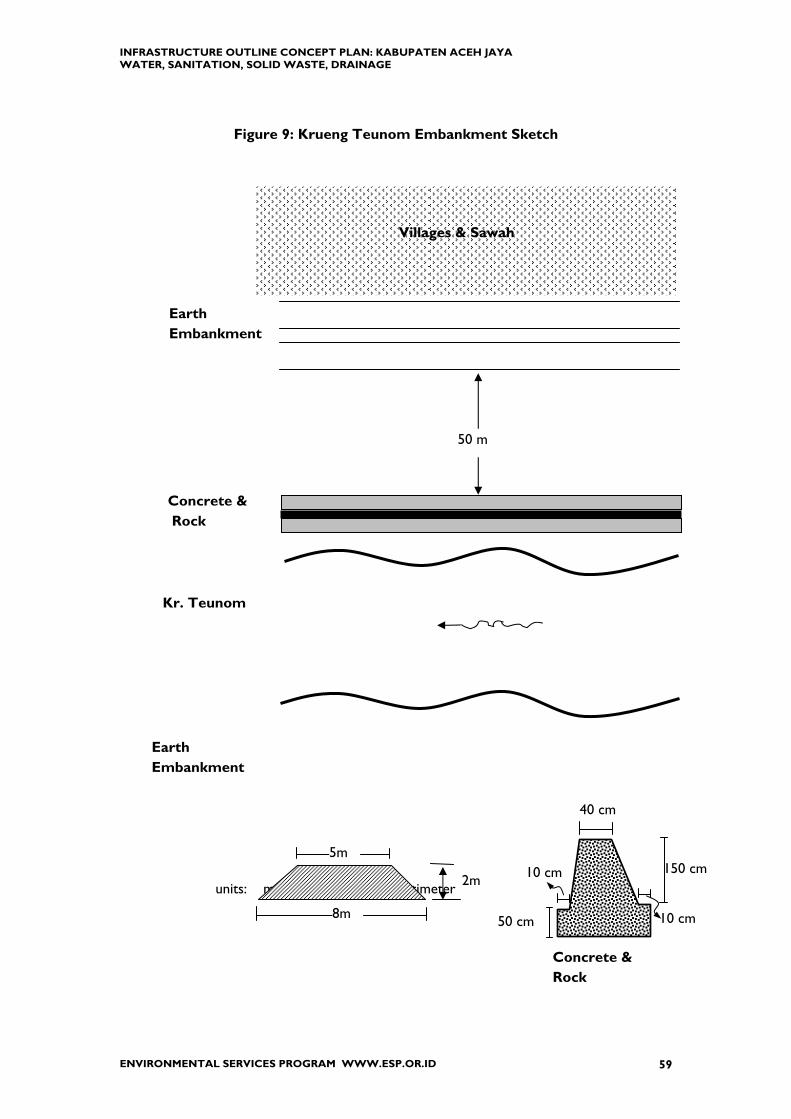
INFRASTRUCTURE OUTLINE CONCEPT PLAN: KABUPATEN ACEH JAYA WATER, SANITATION, SOLID WASTE, DRAINAGE
ENVIRONMENTAL SERVICES PROGRAM WWW.ESP.OR.ID 59
Figure 9: Krueng Teunom Embankment Sketch
units: m = meter and cm = centimeter
50 m
Villages & Sawah
Earth Embankment
Concrete & Rock
Kr. Teunom
8m
Earth Embankment
2m 150 cm
50 cm
5m
40 cm
Concrete & Rock
10 cm
10 cm
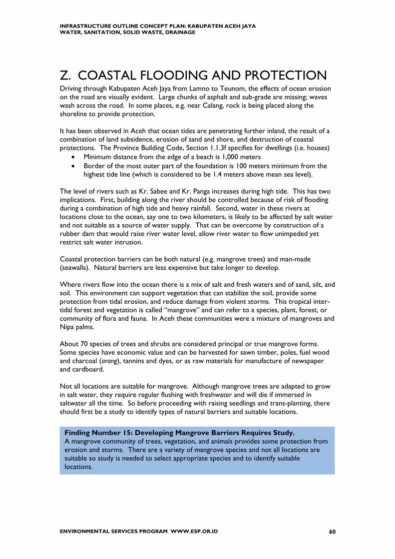
INFRASTRUCTURE OUTLINE CONCEPT PLAN: KABUPATEN ACEH JAYA WATER, SANITATION, SOLID WASTE, DRAINAGE
ENVIRONMENTAL SERVICES PROGRAM WWW.ESP.OR.ID 60
Z. COASTAL FLOODING AND PROTECTION Driving through Kabupaten Aceh Jaya from Lamno to Teunom, the effects of ocean erosion on the road are visually evident. Large chunks of asphalt and sub-grade are missing; waves wash across the road. In some places, e.g. near Calang, rock is being placed along the shoreline to provide protection. It has been observed in Aceh that ocean tides are penetrating further inland, the result of a combination of land subsidence, erosion of sand and shore, and destruction of coastal protections. The Province Building Code, Section 1.1.3f specifies for dwellings (i.e. houses)
• Minimum distance from the edge of a beach is 1,000 meters • Border of the most outer part of the foundation is 100 meters minimum from the
highest tide line (which is considered to be 1.4 meters above mean sea level). The level of rivers such as Kr. Sabee and Kr. Panga increases during high tide. This has two implications. First, building along the river should be controlled because of risk of flooding during a combination of high tide and heavy rainfall. Second, water in these rivers at locations close to the ocean, say one to two kilometers, is likely to be affected by salt water and not suitable as a source of water supply. That can be overcome by construction of a rubber dam that would raise river water level, allow river water to flow unimpeded yet restrict salt water intrusion. Coastal protection barriers can be both natural (e.g. mangrove trees) and man-made (seawalls). Natural barriers are less expensive but take longer to develop. Where rivers flow into the ocean there is a mix of salt and fresh waters and of sand, silt, and soil. This environment can support vegetation that can stabilize the soil, provide some protection from tidal erosion, and reduce damage from violent storms. This tropical inter-tidal forest and vegetation is called “mangrove” and can refer to a species, plant, forest, or community of flora and fauna. In Aceh these communities were a mixture of mangroves and Nipa palms. About 70 species of trees and shrubs are considered principal or true mangrove forms. Some species have economic value and can be harvested for sawn timber, poles, fuel wood and charcoal (arang), tannins and dyes, or as raw materials for manufacture of newspaper and cardboard. Not all locations are suitable for mangrove. Although mangrove trees are adapted to grow in salt water, they require regular flushing with freshwater and will die if immersed in saltwater all the time. So before proceeding with raising seedlings and trans-planting, there should first be a study to identify types of natural barriers and suitable locations.
Finding Number 15: Developing Mangrove Barriers Requires Study. A mangrove community of trees, vegetation, and animals provides some protection from erosion and storms. There are a variety of mangrove species and not all locations are suitable so study is needed to select appropriate species and to identify suitable locations.

INFRASTRUCTURE OUTLINE CONCEPT PLAN: KABUPATEN ACEH JAYA WATER, SANITATION, SOLID WASTE, DRAINAGE
ENVIRONMENTAL SERVICES PROGRAM WWW.ESP.OR.ID 61
Figure 10 shows distribution of mangroves in Aceh Province in Year 2000. District names have been added because in Year 2000 Kabupaten Aceh Jaya was still part of Kabupaten Aceh Barat. The locations shown for Aceh Jaya on the map are
Krueng Lambesso (Kec. Jaya) Lhok Kruet and vicinity Krueng Sabee
According to local residents before the tsunami there were also mangrove concentrations around Krueng Panga and Krueng Teunom although these are not shown in Figure 10. Thus the first step toward developing a mangrove refurbishment program would be to assess current conditions in previously existing mangrove areas. The second step would be to identifying mangrove species based on suitability for specific site conditions and on economic potential of harvested wood (e.g. for lumber, charcoal, chemicals).

INFRASTRUCTURE OUTLINE CONCEPT PLAN: KABUPATEN ACEH JAYA WATER, SANITATION, SOLID WASTE, DRAINAGE
ENVIRONMENTAL SERVICES PROGRAM WWW.ESP.OR.ID 62
Figure 10: Map of Mangrove Locations—Aceh Year 2000

INFRASTRUCTURE OUTLINE CONCEPT PLAN: KABUPATEN ACEH JAYA WATER, SANITATION, SOLID WASTE, DRAINAGE
ENVIRONMENTAL SERVICES PROGRAM WWW.ESP.OR.ID 63
AA. REBUILDING HOUSES ON FLOOD PRONE LAND
There is no obligation or requirement to relocate people. The decision to return to the previous location of their house or to move to a new location is decided by the people concerned. So if the people insist to rebuild on their previous house which is within 1000 meters of the beach or within 100 meters of the full moon high tide, then the government will not prevent it. When an individual insists on rebuilding “on my land” where it was previously and the location does not meet Province Building Standards, then the NGO committed to providing housing can take one of four actions:
1) Refuse to participate 2) Build it and get a letter of release from the homeowner and from the village leader 3) Organize relocation within the village or outside the village (e.g. owner gives original
land to the government to make into open space and in exchange receives land in a more secure location)
4) Engineer flood control measures (a) construct a protective embankment (dike)
[expensive, needs geo-technical study; failure catastrophic] (b) elevate the house
(i) stilts for wooden houses [least expensive] (ii) concrete blocks (piers) for concrete & masonry houses
[expensive because for earthquake protection a massive concrete footer is needed to provide stability during earth movement]
(iii) raise level of the land then proceed with construction (e.g. import soil and rock, then construct slab-on-grade)
Government should not be obligated to provide complicated or expensive protections for people deliberately building in flood-prone areas. Actions Government can take include:
• prepare and publish maps showing land elevations, distances from the ocean, and recommended “no build” areas
• facilitate land exchanges • demonstrate mitigation measures such as elevating the house • improve coastal protections.
Outline Plan for Drainage Infrastructure Year 2006-2007
Repair broken river embankment of Kr. Teunom Coordinate with NAD Propinsi PU to complete DED for Kr. Lambesso and
Kr. Sabee Years 2008-2010
Complete improvements of river flooding projects
INFRASTRUCTURE OUTLINE CONCEPT PLAN: KABUPATEN ACEH JAYA WATER, SANITATION, SOLID WASTE, DRAINAGE
ENVIRONMENTAL SERVICES PROGRAM WWW.ESP.OR.ID 64
13. OTHER INFRASTRUCTURE The focus of this assessment is on WATSAN infrastructure but in Aceh Jaya it is equally important to emphasize infrastructure that will promote the economy, for example roads, fishing industry, and markets. 1. Roads The earthquake and tsunami destroyed bridges and roads throughout the Kabupaten making travel by motor vehicle into and out the Kabupaten and between Kecamatan almost impossible. Initial assistance for many areas in the Kabupaten came by boat and plane. As discussed earlier, USAID is financing a new road from Banda Aceh to Meulaboh and organization such as Catholic Relief Services and Japanese International Cooperation Society (JICS) are repairing the existing road. Roads will continue to be a priority during the next several years. 2. Fishing Industry This was one of the major economic sectors before the earthquake and tsunami. Major impediments to current development include limitations of roads to transport fish to neighboring areas and lack of ice to keep the catch cold. Constructing an ice factory should be a priority at a location that can serve the area from Calang south to Teunom. 3. Markets In Aceh Province the market (pasar) is located in the Ibu Kota Kecamatan and is a major economic center within the Kabupaten. Markets in Aceh Jaya appear to be hastily constructed from wood and without any infrastructure (water supply, drainage), perhaps waiting plans and funding for more permanent facilities. Needed is a Market Infrastructure Improvement Program (MIIP) similar to those implemented through the Integrated Urban Infrastructure Development Program (IUIDP) funded by World Bank and Asian Development Bank elsewhere in Indonesia. Typically markets are in an open area, centrally located, close to road network, and typically the largest single source of solid waste in the Kecamatan. Market infrastrucuture ususally includes
Water supply (one or two public taps) Sanitation (toilet or MCK) Solid Waste Transfer Station Drainage Connecting roads for vehicles to deliver and pick-up items
It is common to locate the central bus terminal close to the market so some infrastructure facilities can be shared. Public taps need to be strongly built to withstand multiple users and equipped with catch basins or gravel drains to keep water off the ground and from ponding. Toilets need a large septic tank that can be pumped at least once a year and accessed by a septic tank pumper. Solid waste bins need to be situated so people can put trash inside it, thus either low height or accessed by an elevated ramp so the person drops trash down and into the bin. Drainage channels are needed inside the market particularly where fruit, vegetables, meat, and fish are sold. Improving exterior drainage can positively impact public health by reducing mosquito breeding places. No one single structure will correct water ponding at most markets. It will require a combination of earthwork to create sloped land, and installation of drainage channels to convey water away. The road network round the market needs to be

INFRASTRUCTURE OUTLINE CONCEPT PLAN: KABUPATEN ACEH JAYA WATER, SANITATION, SOLID WASTE, DRAINAGE
ENVIRONMENTAL SERVICES PROGRAM WWW.ESP.OR.ID 65
sufficiently wide to accommodate flow of traffic past vehicles stopped to unload and load items. Infrastructure facilities for markets are not complicated; can have an immediate, positive impact; need to be strongly built due to large number of users; and should be sized to accommodate typical users. Finding Number 16: Market Infrastructure Improvement Program (MIIP).
Markets are a major economic center in sub-districts (Kecamatans) and would benefit from an organized, focused program to provide basic infrastructure for water supply (public taps), sanitation (MCK), solid waste (collection point), and drainage. This can be a fast, positive, visual demonstration of government action to help the people.

INFRASTRUCTURE OUTLINE CONCEPT PLAN: KABUPATEN ACEH JAYA WATER, SANITATION, SOLID WASTE, DRAINAGE
ENVIRONMENTAL SERVICES PROGRAM WWW.ESP.OR.ID 66
Institutions to Implement and Manage Infrastructure This section describes current status of institutions responsible for managing infrastructure and recommends an approach for each infrastructure sector.
BB. WATER SUPPLY The usual progression for development of water agencies in Indonesia is:
HIPAM to PDAM17
HIPAM (Himpunan Pengelola Air Minum) is a community managed system. NGOs developing village water systems are establishing village water management committees.
PDAM (Perusahan Daerah Air Minum) is the water supply enterprise established by a District (Kabupaten or Kotamadya) and that earns sufficient revenues to cover costs. It is possible to have more than one PDAM in a District. Within the PDAM there can be
a. IKK (Ibu Kota Kecamatan) is a water system established in a sub-district capital
b. Cabang is a branch of a PDAM PDAM is not responsible for water supply in rural area; it is the Camat and the local government. There has never been a PDAM in Kabupaten Aceh Jaya. Water Supply in Lamno was BPAM and in IKK in Calang, and Teunom. Considering present conditions, the most practical management scheme would be to continue establishing HIPAM in villages and as water systems are constructed in Lamno, Calang, and Teunom to establish IKK. The health departments at Kabupaten and Kecamatan are supposed to monitor water quality but lack staff and equipment. The Province Health Department has trained staff and adequate laboratory equipment and reagents to monitor chemical and biological water quality. In Aceh Jaya NGOs such as MERLIN, IRC, and OXFAM are providing training and equipment to local Health Departments.
CC. SANITATION There is no institution in the Kabupaten responsible for treatment or disposal of human wastes. One method of control would be for the Kabupaten agency that issues building permits (Izin Mendirikan Bangunan, IMB) to include a requirement for waste disposal and specify each homeowner is responsible. Additionally the IMB should specify access to the septic tank, i.e. sufficient space for a truck or a hand-pulled cart with a tank and pump to place a hose into the septic tank to empty its contents. As a general policy, when waste disposal is centralized wastewater collection and treatment (i.e. “pipe”) responsibility should be assigned to PDAM because:
17 In previous years there was an intermediate agency called BPAM (Badan Perusahan Daerah Air Minum) that was managed by Public Works. Lamno was a BPAM.

INFRASTRUCTURE OUTLINE CONCEPT PLAN: KABUPATEN ACEH JAYA WATER, SANITATION, SOLID WASTE, DRAINAGE
ENVIRONMENTAL SERVICES PROGRAM WWW.ESP.OR.ID 67
• PDAM has experience installing and maintaining pipes and operating treatment facilities
• PDAM has customer data and already invoices for water so adding an additional fee for wastewater disposal is simple and straight forward.
An example is PDAM Kota Bandung which has a Divisi Air Kotor (Wastewater Division) to operate IPAL Bonjongsoang. However when human wastes are transported by truck (i.e. “wheels”) to a disposal site, then the Kabupaten Dinas Kebersihan should be responsible for the pumper trucks and disposal site (IPLT) because they have similar experience with solid waste.
DD. SOLID WASTE Kabupaten Aceh Jaya has no Dinas Kebersihan to organize and manage solid waste facilities. At the moment DISPENDA (finance department) is planning solid waste. The strategy for developing an organized solid waste management system is to:
1. Establish a work unit responsible for solid waste 2. Locate and design an appropriate TPA (Final Disposal Site) 3. Define transporting systems and locate TPS (Transfer Station) 4. Tender and construct TPS and TPA 5. Train operators (Collection, Transfer, Transport, Disposal) 6. Promote and develop solid waste management systems for recycling and composting
The Mukim, an adat organization unique to Propinsi NAD can be an active participant promoting proper placement of solid waste, but is more oriented toward community matters than infrastructure management. Since collection is done at neighborhood level, the Desa government staff will need equipment and training for collection activities. For transfer and disposal activities it is recommended to establish a Solid Waste Management Unit at Kecamatan level. The Camat is likely to have more control than the Kabupaten over facilities in their sub-district because:
Kabupaten agency for SW is not yet established; and Travel distances from Kabupaten IbuKota in Calang to proposed TPS and TPA
locations are very long probably resulting in infrequent site visits by Kabupaten staff. The Solid Waste Management Unit would be placed under supervision of the Camat Services and Social Affairs unit (Seksi Pelayanan dan Masalah Sosial, “YANSOS”). This can be done by the Kabupaten (Bupati, DPRD). Placing the SW Unit as a sub-section rather than a section avoids having to convince Central Government to change national laws and regulations relating to Kecamatan government structure. The Sub-unit for Solid Waste Infrastructure Management [Sub-SWIM] would consist of one individual whose duties include:
• Inspect TPS and TPA facilities, operations, and maintenance according to standard checklists
• Monitor condition and usage of equipment used for collection and disposal according to standard checklists
• Coordinate with other Camat agencies to assess level of service and public’s willingness-to-pay

INFRASTRUCTURE OUTLINE CONCEPT PLAN: KABUPATEN ACEH JAYA WATER, SANITATION, SOLID WASTE, DRAINAGE
ENVIRONMENTAL SERVICES PROGRAM WWW.ESP.OR.ID 68
• Contact Kabupaten and Province Technical Advisors to explain problems and get their advice and assistance to resolve
EE. DRAINAGE Public Works (PU) is the organization responsible for macro-drainage, flood protection, and shoreline protection. PU also designs and constructs micro-drainage however it would be better to make the builder of the road, or house or market or building responsible for design and construction, and for making the interconnection with existing drainage structures. Similar to Sanitation, this could be enforced through the IMB (building permit). This is important because some NGOs now building houses are not doing anything about drainage, leaving it to the new homeowner to complete. Dinas (Local Government Office) is responsible for maintenance of drains however there are too many drains and not enough staff or money. A better approach for micro-drainage is to involve the community in the planning and development in order to create a sense of ownership and responsibility. . In some places people maintain their neighborhood by kerja bakti (dedicated work by unpaid volunteers). In Aceh this could be organized by the Keuchik, who is already involved in community matters. In summary:
• Public Works---macro drainage • Kecamatan---enforce requirements of micro-drainage for housing; develop and
maintain Pasar drainage • Community---plan, design, implement, and manage local drains
Finding Number 17: Manage Solid Waste at Kecamatan. Kab. Aceh Jaya does not now have a Dinas Kebersihan and the infrastructure recommended for solid waste----TPS and TPA in each Kecamatan---can be managed by the Kecamatan. Thus it is recommended to develop a Sub-unit for Solid Waste Management under supervision of the Camat.
Finding Number 18: Make Community Responsible for Drainage O&M. “Strategically the highest likelihood for success rests on the devolution of design, implementation, ownership, and management responsibilities to local communities” .

INFRASTRUCTURE OUTLINE CONCEPT PLAN: KABUPATEN ACEH JAYA WATER, SANITATION, SOLID WASTE, DRAINAGE
ENVIRONMENTAL SERVICES PROGRAM WWW.ESP.OR.ID 69
Figure 19: Combined Sullage and Stormwater Drain
[from World Health Organization publication]
The small channel in the drain is to discharge sullage, and its rounded form allows small amounts of water to flow at sufficient velocity to keep solids in suspension. This practice is not ideal as people, animals, and insects can come into direct contact with the waste water and build up of solid waste restricts flow, but it is better than allowing waste water to pond.

INFRASTRUCTURE OUTLINE CONCEPT PLAN: KABUPATEN ACEH JAYA WATER, SANITATION, SOLID WASTE, DRAINAGE
ENVIRONMENTAL SERVICES PROGRAM WWW.ESP.OR.ID 70
14. ENVIRONMENTAL ANALYSIS OF INFRASTRUCTURE PROJECTS The Government of Indonesia requires all development projects be studied to determine potential environmental impacts and to establish suitable mitigating measures. The scope of analysis depends on size and location of the project as shown in the table below. In Indonesia the required documents before a project begins are: • AMDAL = Analisis Mengenai Dampak Lingkungan---Environmental Impact Assessment • UKL = Upaya Pengelolaan [Kelola] Lingkungan Hidup—Environmental Management Plan • UPL = Upaya Pemantauan Lingkungan Hidup---Environmental Monitoring Plan
Table 28: Government of Indonesia Threshold Criteria for Projects Requiring Environmental Review (AMDAL or UKL/UPL)
Sector and Activity SCALE AMDAL UKL / UPL WATER SUPPLY
Water Intake from Surface Sources (River, Lake) or Springs Debit > 250 L/sec 50 – 250 L/sec
Ground Water Intake Debit > 50 L/sec 5 -50 L/sec Piped Transmission Line Length > 10 km 2 – 10 km Water Treatment Plant Production ‘--- > 50 L/sec Distribution Network Area served > 500 Ha 100 – 500 Ha
WASTEWATER Septage Disposal Plant (IPLT) Plant area > 2 Ha < 2 Ha
SOLID WASTE
Development of transfer station Throughput (tons / day) > 1000 TPD < 1000 TPD
Final disposal with open dumping system all ‘---
Final disposal in tides area Area or capacity
> 5 Ha or > 5000 tons
< 5 Ha or < 5000 T
Controlled landfill system/sanitary landfill (non-hazardous waste)
Area or capacity
> 10 Ha or > 10,000 tons
< 10 Ha or < 10,000 tons
DRAINAGE Drainage in small-sized city Length > 5 km References: Decree of the State Minister of the Environment No. 17/2001, dated 22 May 2001 and No. 86/2002, dated 28 October 2002; and Decree of the Minister of Settlements and Regional Infrastructure No. 17/KPTS/2003, dated 3 February 2003. Ha = Hectares; km = kilometers; L/sec = Liters per second; tpd = tons per day

INFRASTRUCTURE OUTLINE CONCEPT PLAN: KABUPATEN ACEH JAYA WATER, SANITATION, SOLID WASTE, DRAINAGE
ENVIRONMENTAL SERVICES PROGRAM WWW.ESP.OR.ID 71
Donors such as World Bank and USAID have their own requirements and regulations for environmental analysis, public hearings, and documentation. Best practice is to do the environmental assessment on parallel track to complete both Indonesian and Donor requirements at the same time. Finding Number 19: Environmental Impact Analysis.
Scope of Environmental Impact Analysis depends on size of project and source of funding as individual donors have requirements different from Government of Indonesia. For almost all proposed infrastructure projects GOI UKL / UPL is sufficient.

INFRASTRUCTURE OUTLINE CONCEPT PLAN: KABUPATEN ACEH JAYA WATER, SANITATION, SOLID WASTE, DRAINAGE
ENVIRONMENTAL SERVICES PROGRAM WWW.ESP.OR.ID 72
15. ESTABLISHING PRIORITIES There are significant differences among the six kecamatans so with limited resources it is necessary to assign priorities for infrastructure development. The method used to establish priorities for Kecamatan development consisted of these steps:
1) Develop criteria and assign a point value 2) Collect data about Kecamatans 3) Assign points according to the criteria 4) Add points to establish a ranking.
BRR states its top three priorities as “Number 1 Housing; Number 2 Housing; and Number 3 Housing”. Based on further discussions with BRR and others, the following criteria and priorities are proposed for kecamatan development in Kabupaten Aceh Jaya.
Table 29: Criteria, Sub-Divisions, and Assigned Points
Criteria Sub-Divisions Pts Criteria Sub-Divisions Pts
>3,000 10 A = Kab. Capital, Port, Airport 10
2,000 to 3,000 7
<2,000 5
>6,000 10 Gravity 10
3,000 to 6,000 7 Pumped 7
<3,000 5 Wells 5
>40% of Pop 10 Pop.> 15,000 10
20% to 39% 7 10,00 to15,000 7
<20% 5 Pop. < 10,000 5
San. & SW Infra-structure
Economic Develop-
ment
Flooding
Services to New Housing
Services to IDP
B = Proximity to Banda Aceh or Meulaboh
5
Expand Water Supply
Values of 10—7—5 are used to create recognizable differences among the Kecamatans being evaluated. Criteria • NGOs are constructing new housing in all six Kecamatans. To make a house livable
there must be water supply and a system to remove wastewater. • IDP’s are living in tents and barracks (Temporary Living Centers). Water is provided by
pipeline, tanker truck, or dug wells. Although efforts are being made to build houses quickly, TLCs are likely to be in use for the next several years so water supply should become piped.
• River flooding adversely affects people, housing, land used for agriculture • Calang is designated as the Kabupaten capital. An ocean harbor is under construction
and there are plans for an airport. Lamno is close to Banda Aceh and Teunom to Meulaboh so these two towns will have larger economies than those in the interior of the Kabupaten
• It will be more financially sustainable to provide water by gravity rather than by pumped
systems. Shallow wells are least expensive but likely to become contaminated due to the current system of human waste disposal.

INFRASTRUCTURE OUTLINE CONCEPT PLAN: KABUPATEN ACEH JAYA WATER, SANITATION, SOLID WASTE, DRAINAGE
ENVIRONMENTAL SERVICES PROGRAM WWW.ESP.OR.ID 73
• Sanitation and solid waste services involve collecting and transporting waste materials by
truck which is more economical where populations are large.
Table 30: Data for Establishing Priorities for Kecamatan Development
Kecamatan New Housing
No. of IDP Flooding Development
RegionWater Supply
Pop.Yr. 2010
Jaya 3,250 >1,000 Yes B G 19,400Sampoiniet 2,649 1,731 P 11,600Setia Bakti 1,950 3,670 A G 6,300Krueng Sabee 1,460 7,590 Yes A G 11,200Panga 1,416 1,946 W 5,400Teunom 3,145 4,211 44% of Pop B P 15,100
Table 31: Kecamatans Prioritized for Development
Kecamatan New Housing
No. of IDP Flooding Development
RegionWater Supply
Pop.Yr. 2010 Points Rank
Teunom 10 7 10 5 7 10 49 1Jaya 10 5 5 5 10 10 45 2Krueng Sabee 5 10 5 5 10 7 42 3Setia Bakti 5 7 5 10 5 32 4Sampoiniet 7 5 7 7 26 5Panga 5 5 5 5 20 6

INFRASTRUCTURE OUTLINE CONCEPT PLAN: KABUPATEN ACEH JAYA WATER, SANITATION, SOLID WASTE, DRAINAGE
ENVIRONMENTAL SERVICES PROGRAM WWW.ESP.OR.ID 74
16. PROPOSED COMMITMENTS There are three main sources of financing for the reconstruction program: Government of Indonesia resources, donor contributions (e.g. UNICEF, USAID), and voluntary contributions through NGOs. BRR policy is that the agency providing shelter should also provide water supply and sanitation. For the most part NGOs are doing this and also for other buildings they construct such as schools and health clinics. Some are also doing drainage but this is not consistent so BRR should add a requirement to NGOs to be responsible for drainage. Known commitments are: 2) Lamno (Kec. Jaya) Water Supply Scheme---OXFAM has funded Detailed Engineering
Design. Not clear who will fund construction. that should be done in stages to assure financial sustainability.
3) Sampoiniet 15-Village Water Supply Scheme---CAM (Indonesian NGO) has expressed
interest in developing the waterfall in Sampoiniet that can serve approximately 15 villages in Sampoiniet and Setia Bakti. See Option #1 in

INFRASTRUCTURE OUTLINE CONCEPT PLAN: KABUPATEN ACEH JAYA WATER, SANITATION, SOLID WASTE, DRAINAGE
ENVIRONMENTAL SERVICES PROGRAM WWW.ESP.OR.ID 75
Table 19 and Figure for a description. Follow-up is needed to confirm this NGO’s intent to proceed.
4) Calang Water Supply---For Old Calang, particularly the government and NGO camp
area, IRC plans to do a water distribution system with possible technical and financial assistance from American Red Cross.
5) Kabupaten Water Quality Laboratory---Calang NGOs (MERLIN, OXFAM, ACF, IRC)
are preparing a Memorandum of Understanding to construct a water quality laboratory. USAID ESP-Aceh has agreed to provide equipment, chemicals, and training if there is assurance the laboratory can be sustainable, e.g. by getting an Indonesian agency such as the Kabupaten Health Department to assume responsibility for the lab.
6) Solid Waste Facilities---UNICEF and UNDP is committed to providing technical
assistance and equipment for development of TPS and TPA. UNICEF will donate 1 garbage-dump-truck to be operated in the TLCs UNICEF will support IRC to build one permanent septage dump site to serve Calang
Barracks and will provide a de-sludging truck UNDP will provide one 3 trucks to cover garbage collection in Setia Bakti, Krueng
Sabee, Panga, Teunom; and a bulldozer and backhoe for use at the dump-site at Keutapang (Krueng Sabee)
7) Krueng Teunom Drainage Repair---Danish Red Cross is preparing a Concept Note
conveying their commitment to patch the embankment of Kr. Teunom.

INFRASTRUCTURE OUTLINE CONCEPT PLAN: KABUPATEN ACEH JAYA WATER, SANITATION, SOLID WASTE, DRAINAGE
ENVIRONMENTAL SERVICES PROGRAM WWW.ESP.OR.ID 76
17. SUMMARY OF INFRASTRUCTURE NEEDS The following tables summarize infrastructure projects and estimated costs that do NOT include
• Land Acquisition • Detailed Engineering Design, Environmental Impact Assessments, Construction
Management (typically 12.5% of construction cost) • Commercial Contingencies (inflation, currency exchange) • Physical Contingencies (changes to quantities or unit costs) • Value Added Tax (Pajak Pertambahan Nilai, 10%)
Cost data is from fourth quarter of 2005.
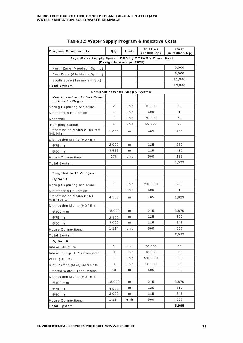
INFRASTRUCTURE OUTLINE CONCEPT PLAN: KABUPATEN ACEH JAYA WATER, SANITATION, SOLID WASTE, DRAINAGE
ENVIRONMENTAL SERVICES PROGRAM WWW.ESP.OR.ID 77
Table 32: Water Supply Program & Indicative Costs
P ro g ram C o m p o n en ts Q ty U n its U n it C o st (X 1000 R p )
C o st (in m illio n R p )
N orth Z one (M eudeun S pring ) 6 ,000
E ast Z one (G le M e lha S pring ) 6 ,000
S ou th Z one (T eum arem S p .) 11 ,900
T o ta l S ystem 23 ,900
N ew L o catio n o f L h o k K ru et + o th er 2 v illag es
S pring C ap tu ring S truc tu re 2 un it 15 ,000 30
D isin fec tion E qu ipm ent 1 un it 600 1
R eserv o ir 1 un it 70 ,000 70
P um p ing S ta tion 1 un it 50 ,000 50
T ransm ission M a ins Ø 100 m m (H D P E )
1 ,000 m 405 405
D istribu tion M a ins (H D P E )
Ø 75 m m 2,000 m 125 250
Ø 50 m m 3,568 m 115 410
H ouse C onnec tions 278 un it 500 139
T o ta l S ystem 1 ,355
T arg eted to 12 V illag es
O p tio n I
S pring C ap tu ring S truc tu re 1 un it 200 ,000 200
D isin fec tion E qu ipm ent 1 un it 600 1
T ransm ission M a ins Ø 150 m m /H D P E
4,500 m 405 1 ,823
D istribu tion M a ins (H D P E )
Ø 100 m m 18,000 m 215 3 ,870
Ø 75 m m 2,400 m 125 300
Ø 50 m m 3,000 m 115 345
H ouse C onnec tions 1 ,114 un it 500 557
T o ta l S ystem 7 ,095
O p tio n II
In take S truc tu re 1 un it 50 ,000 50
In take pum p (4L /s) C om p le te 3 un it 10 ,000 30
W T P (10 L /s) 1 un it 500 ,000 500
D ist. P um ps (5L /s) C om p le te 3 un it 30 ,000 90
T rea ted W ate r T rans. M a ins 50 m 405 20
D istribu tion M a ins (H D P E )
Ø 100 m m 18,000 m 215 3 ,870
Ø 75 m m 4,900 m 125 613
Ø 50 m m 3,000 m 115 345
H ouse C onnec tions 1 ,114 u n it 500 557
T o ta l S ystem 5,995
Jaya W ater S u p p ly S ystem D E D b y O X F AM 's C o n su ltan t(D es ig n h o rizo n yr. 2025)
S am p o in ie t W ater S u p p ly S ystem

INFRASTRUCTURE OUTLINE CONCEPT PLAN: KABUPATEN ACEH JAYA WATER, SANITATION, SOLID WASTE, DRAINAGE
ENVIRONMENTAL SERVICES PROGRAM WWW.ESP.OR.ID 78
Water Supply Program & Indicative Costs (continued)
P ro g ram C o m p o n en ts Q ty U n its U n it C o st (X 1000 R p )
C o st (in m illio n R p )
S pring C apturing S tructure
D isin fection E quipm ent 3 unit 600 2
T ransm ission M ains 100 m m H D P E 5,500 m
215 1,183
D istribution M ains
Ø 75 m m 6,000 m 125 750
Ø 50 m m 7,000 m 115 805
H ouse C onnections 756 unit 500 378
T o tal S ystem 3,117
In take S tructure 1 unit 150,000 150
Intake pum p (7.5 L/s) 3 unit 20,000 60
R aw water T ransm ission M ains Ø 150 m m /H D P E
12,000 m 405 4,860
P ackage T reatm ent
10 L/sec 1 unit 500,000 500
5 L/sec 1 unit 250,000 250
D istribution M ains
Ø 100 m m 5,376 m 215 1,156
Ø 75 m m 10,752 m 125 1,344
Ø 50 m m 10,752 m 115 1,236
H ouse C onnections 1,344 unit 500 672
T o tal S ystem 10,228
S pring C apturing S tructure
D isin fection E quipm ent 1 unit 600 1
T ransm ission M ains
D istribution M ains
Ø 75 m m 2,000 m 125 250
Ø 50 m m 3,360 m 115 386
H ouse C onnections 268 unit 500 134
T o tal S ystem 771
S pring C apturing S tructure 1 unit 150,000 150
D isin fection E quipm ent 1 unit 600 1
T ransm ission M ains 100 m m H D P E 6,500 m
215 1,398
D istribution M ains
Ø 75 m m 6,000 m 125 750
Ø 50 m m 7,000 m 115 805
H ouse C onnections
T o tal S ystem 4,395
K ru en g S ab ee W ater S u p p ly S ystem(K eu d e K . S ab ee & It's S u rro u n d in g V illag es)
P an g a W ater S u p p ly S ystem
E x isting
(E x isting)
C alan g W ater S u p p ly S ystem
S etia B akti W ater S u p p ly S ystem
3 units E x isting

INFRASTRUCTURE OUTLINE CONCEPT PLAN: KABUPATEN ACEH JAYA WATER, SANITATION, SOLID WASTE, DRAINAGE
ENVIRONMENTAL SERVICES PROGRAM WWW.ESP.OR.ID 79
Water Supply Program & Indicative Costs (continued)
Intake Structure 1 unit 100,000 100
Intake Pumps 7.5 L/sec 3 unit 20,000 60
Package Treatment (15 L/s) 1 unit 750,000 750
Ground Distribution Reservoir 1 unit 150,000 150
Distribution Pumps 3 unit 30,000 90
Treated Water Transmission Mains (Ø150 mm/HDPE Pipes)
1,000 m 405 405
Distribution Mains
Ø100 mm 14,000 m 215 3,010
Ø75 mm 7,248 m 125 906
Ø50 mm 14,992 m 115 1,724
House Connections 1,812 unit 500 906
Total System 8,101
Detailed Engineering Design for 5 Kecamatan 300
Teunom Water Supply System
Table 33: Sanitation Program & Indicative Costs
COST COST Million Rp Million Rp
Location for IPLTPilot Studies for Alternative Wastewater Treatments
CAMPAIGN Public Education
Septic Tank Truck & Pump (3) 825
(Rp 275 million/unit)
MCK at Pasars (3) 300 MCK at Pasars (3) 300
(Rp 100 million/unit)
IPLT:
Jaya (5 m3/day) 1140
Sampoiniet (3 m3/day) 950
Calang (3 m3/day) 950
Teunom (5 m3/day) 1140
Total Cost for Aceh Jaya 1125 3340
STUDIES
PROCUREMENT
DESIGN & CONSTRUCT
2006 - 2007 2008 - 2010

INFRASTRUCTURE OUTLINE CONCEPT PLAN: KABUPATEN ACEH JAYA WATER, SANITATION, SOLID WASTE, DRAINAGE
ENVIRONMENTAL SERVICES PROGRAM WWW.ESP.OR.ID 80
Table 34: Solid Waste Program & Indicative Costs
COST COST Million Rp Million Rp
Field Studies to Confirm Data Estimates (e.g. Quantity and Type of SW Produced)
50
Technical Studies to Develop Locations for TPS & TPA Jaya, Sampoiniet, Calang and Teunom
240
Community Discussions to Agree TPS and TPA Locations
50
Simplified Leachate and Landfill Gas Collections Systems
150Evaluation of Solid Waste and Lessons Learned (Benefits Evaluation)
150
CAMPAIGNCommunity Development in TPA areas
"Sources Based Solid Waste Management"
TPS at Pasar for the six (3) kecamatan; all are close to pasar or other commercial area
120 TPS at Pasar for the six (3) kecamatan; all are close to pasar or other commercial area
120
TPA Jaya (3.1Ha), including access road
1,127 TPA Sampoiniet (1.9 Ha), including access road
691
TPA Calang(2.8Ha) 1,018 TPA Teunom (3.2 Ha) 1,164
Total 2 collection trucks each has capacity of 4m3, 1(one) Collection Trucks for Jaya and the other for
6001 (one) collection trucks for Teunom which will serve Panga as well.
300
2 units Front-End Loader for TPA 2,200 2 Front-End Loader for TPA 2,200
Total SW Aceh Jaya Program Cost 5,555 4,625
DESIGN & CONSTRUCT
STUDIES
PROCUREMENT
Program Components 2006 - 2007 2008 - 2010

INFRASTRUCTURE OUTLINE CONCEPT PLAN: KABUPATEN ACEH JAYA WATER, SANITATION, SOLID WASTE, DRAINAGE
ENVIRONMENTAL SERVICES PROGRAM WWW.ESP.OR.ID 81
Table 35: Drainage Program & Indicative Costs
2.5 m
Volume Units Cost Total(Rupiah)
Total Cost(Million Rp)
Earth Embankment Construction (1 m length)
13 m3
16.9 m3 120,000 2,028,000
300,000
10 m2 15,000 150,000
Total Cost of 1 m length Rp 2,478,000 2.5
Concrete Rock Construction (1 m length)
1.75 m3 --- ---
1.4 m3 280,000 392,000
0.35 m31,200,000
420,000
1.75 m3 150,000 262,500
Total Cost of 1 m length Rp 1,074,500 1.1
LOCATION Quantity UnitsEarth
EmbnkConcrete
Rock Total Cost
Kr. Teunom 200 m 500 220 720
Labour Cost
COST (million Rupiah)
Grass
Vol. of Concrete Rock
RockSand & Portland Cement Mixtures of 1:3
Description
Earth (compacted)
Loose Earth
Compaction Work
8m
EarthEmbankmen 2m
150 cm
50 cm
5m
40 cm
Concrete & Rock
10 cm
10 cm
120 cm
Muslim Aid, an Indonesian NGO, is doing emergency rehabilitation of the Kotamadya Banda Aceh drainage and flood protection system. For one component of their work they propose to use one-way flow control valves in place of the usual steel or wooden sluice gates to prevent back-flooding which can occur when river water volume is larger than usual, for example after an intense rain storm. The design is known generically as variable orifice with an elastomer material made of neoprene (more resistant to ultra-violet light). The valve has no moving parts and is low maintenance because it is designed to be self-cleaning, i.e. flow velocity at low heads is sufficient to scour debris from the valve. Budget-level cost estimates are US$ 15,000 for one valve and $10,000 for installation. For more information about these valves, contact
Muslim Aid-Indonesia, Jalan Bintara Pineung No. 27, Banda Aceh, Indonesia H. Fadlullah Wilmot, Director, Muslim Aid Indonesia; Cell phone 081-3624-84859 and e-mail [email protected]


INFRASTRUCTURE OUTLINE CONCEPT PLAN: KABUPATEN ACEH JAYA WATER, SANITATION, SOLID WASTE, DRAINAGE
ENVIRONMENTAL SERVICES PROGRAM WWW.ESP.OR.ID 82
APPENDICES
A. SOURCES OF DATA
B. NGO AND DONOR ORGANIZATIONS INTERVIEWED FOR THIS REPORT
C. EXAMPLES OF NGO ACTIVITIES OCT 05—JAN-06 (REPORTED BY KECAMATAN)


APPENDIX A SOURCES OF DATA


INFRASTRUCTURE OUTLINE CONCEPT PLAN: KABUPATEN ACEH JAYA WATER, SANITATION, SOLID WASTE, DRAINAGE
ENVIRONMENTAL SERVICES PROGRAM WWW.ESP.OR.ID 2
APPENDIX A DATA SOURCES FOR NEEDS ASSESSMENT
Indonesian Acronyms www.asia-pacific-action.org/southeastasia/indonesia/resources/language/ Population, Location, and Land Areas • Bureau of Statistics (Badan Pusat Statistik, BPS) for each Kabupaten (District) publishes
each year data about population; organization (sub-districts, villages); production; economy.
• Each Camat (Sub-District) has data about its population • Data on dead and missing organized by District
http://www.humanitarianinfo.org/sumatra/products/statistics/docs/DeathStatisticMay2005.pdf
• “Dissemination Population Census Data of Nanggroe Aceh Darussalam and Nias 2005”,
Presented in Badan Pusat Statistik, Jakarta November 29th 2005. Has data on Year 2005 populations of Districts
Population Growth Rate “Dissemination Population Census Data of Nanggroe Aceh Darussalam and Nias 2005”, Presented in Badan Pusat Statistik, Jakarta November 29th 2005. provides historic population data for the Province. From data in this presentation the growth rate for the Province for the period 1990 to 2000 is calculated to be 1.5%. Historic data for the District shows a decrease then four year increase, then decrease. District Development Plans Indonesia requires District government to prepare
• Rencana Pengembangan Wilyah which is typically a five-year development plan for economy, housing, and infrastructure.
• Rencana Tata Ruang Wilayah which is a spatial plan Within the Kabupaten or Kotamadya this is done by BAPPEDA Damage assessment as of March 2005 and National Government Plans Aceh Blueprint consisting of main volume (English and Indonesian) and 11 sub-volumes (Indonesian), for example Book 3 on infrastructure
http://www.humanitarianinfo.org/sumatra/inc/blueprint_index.asp
INFRASTRUCTURE OUTLINE CONCEPT PLAN: KABUPATEN ACEH JAYA WATER, SANITATION, SOLID WASTE, DRAINAGE
ENVIRONMENTAL SERVICES PROGRAM WWW.ESP.OR.ID 3
Status of Reconstruction and Rehabilitation “Tsunami Recovery Status Report (As of 8 December 2005)” available form HIC web site. Data processed by the United Nations Information Management Service, Office of the UN Recovery Coordinator for Aceh and Nias, in collaboration with the Badan Rehabilitasi dan Rekonstruksi (BRR). “Aceh and Nias One Year After The Tsunami: The Recovery Effort and Way Forward”, a joint report of the BRR and International Partners, Dec-05. BRR’s recovery and reconstruction web-site www.e-aceh-nias.org UN’s web-site for reconstruction, www.humanitariainfo.org. Building Standards including Utilities; Sources of Materials; Procedures for Land Mapping and Community Planning, Humanitarian Information Center for Sumatra, “HIC Shelter Data Pack – 30 July 2005” available from web site
http://www.humanitarianinfo.org/sumatra/ This web site is now administered by United Nations Information Management Systems (UNIMS) Maps The HIC web site has a tab for maps.
http://www.humanitarianinfo.org/sumatra/ NGO Relief Activities in the District http://www.humanitarianinfo.org/sumatra/reliefrecovery/watsan/ has maps and lists of Who is doing What Where • It is preferable to ask the NGO to provide lists of locations and activities in whatever
format they use rather than ask them to complete a specially prepared data collection because NGO’s are burdened with large number of requests for data.
• For Kab. Aceh Jaya, UN Office of Recovery provided list of NGO’s and their activities Major Projects---Proposed Any NGO or relief agency wanting to do a major project should prepare a Project Concept Note and submit to BRR. Purpose is to inform other organizations in order to avoid conflict and duplication; and to assure the proposing organization is serious. These notes are available at the BRR Central Program Operation Center. Contact Ir. Truly Kartika or Ir. Ferdian

INFRASTRUCTURE OUTLINE CONCEPT PLAN: KABUPATEN ACEH JAYA WATER, SANITATION, SOLID WASTE, DRAINAGE
ENVIRONMENTAL SERVICES PROGRAM WWW.ESP.OR.ID 4
Water Supply • PDAM (Perusahan Daerah Air Minum) is the District agency providing water service.
They have records of production, distribution, customers, and tariffs, • PDAM Tirta Mountala (Kab. Aceh Besar) has a Master Plan dated Oct05. • IWACO reports of 1993 provide data about water resources in NAD according to
Watershed Basin and for some Districts (e.g. Aceh Barat and Aceh Jaya) Solid Waste • GTZ Project is identifying sites for a landfill for Kota Banda Aceh which will be located
in Kab. Aceh Besar. Data they use to estimate generation, density, composition could be applied elsewhere in the Province
• Guidelines to estimate generation and equipment for collection and disposal operations
are in Bagian 11: Lalu Lintas, Lingkungan Jalan, Sanitasi dan Persampahan. Methode, Spesifikasi dan Tata Cara December 2002 by Departemen Permukiman dan Prasarana Wilayah, Baden Penelitian dan Pengembangan, Jl. Raden Patah No. 1, Kebayoran Baru, Jakarta
Drainage • The World Bank, Infrastructure Department, East Asia and the Pacific Region: “Appraisal
Report for a Proposed Grant to Muslim Aid for the Emergency Rehabilitation of the Drainage and Flood Protection System of Banda Aceh”, December 15, 2005
• NAD Propinsi Proyek Pengendalian Banjir and Pengamanan Pantai (Proyek PBPP NAD)
(located on same site as BRR) for details about Province projects. Kepala Ir. Mahdani, (081-168-4328)
BRR Contact Ir. Bambang Sudiatmo, Director for WATSAN Wim Stolte, WATSAN International Advisor Staff include Pak Hayat; Pak Darmawel Umar; Pak Hotma


INFRASTRUCTURE OUTLINE CONCEPT PLAN: KABUPATEN ACEH JAYA WATER, SANITATION, SOLID WASTE, DRAINAGE
ENVIRONMENTAL SERVICES PROGRAM WWW.ESP.OR.ID 5
APPENDIX B NGO AND DONOR ORGANIZATIONS INTERVIEWED FOR THIS REPORT


INFRASTRUCTURE OUTLINE CONCEPT PLAN: KABUPATEN ACEH JAYAWATER, SANITATION, SOLID WASTE, DRAINAGE
ORGANIZATIONS INTERVIEWED FOR THIS REPORT
Individuals Interviewed during Data Collection and Analysis for Infrastructure Assessment of Kabupaten Aceh Jaya
WORKING NAME ORGANIZATION POSITION LOCATION CONTACT E-MAIL
Aceh JayaSaliza Mohamadar
Badan Rehabilitasi dan Rekonstruksi (BRR)
Head of Aceh Jaya Regional Office Calang --- [email protected]
Aceh Jaya David Sanfiel MERLIN WATSAN Coordinator Calang 081-2600-1446 [email protected]
Aceh JayaMarion van der Reijden MERLIN
Project Coordinator West Coast Calang --- [email protected]
Aceh Jaya Joel Anderson UN Office of Recovery Coordinator Assistant Calang left country left country
Aceh Jaya Jorg Meier UN Office of Recovery CoordinatorOfficer In Charge, Aceh Field
Office Calang [email protected]
Aceh Province Ir. MahdaniNAD Propinsi PU
Proyek PBPP Assisten Perencenaan Banda Aceh 081-1684328 macro-drainage and coastal protection
Aceh Province Tim WalshUN Development Programme
(UNDP) Solid Waste Coordinator Banda Aceh --- ---
Calang Chairul Anwar BAPPEDA-Aceh Jaya Kabid Perencanan Calang 081-5163-52505 ---
Calang Kim Conolly International Rescue Committee Field Coordinator Calang Calang --- ---
Calang Lisa Owen International Rescue Committee Field Coordinator Calang Calang --- ---
Calang Jhon SrivenUN Development Programme
(UNDP) Programme Assistant Calang 081-2809-7565 [email protected]
Calang Sean MulcairUN High Commisioner for Refugees
(UNHCR)Construction Engineer, Shelter
Programme Calang081-2107-9554
(may have left country) [email protected]
Lamno, Calang Nicholas Brooks OXFAMSolid Waste Management
Coordinator Banda Aceh 081-360-413615 [email protected]
northern Aceh Jeffrey Jewett American Red Cross Senior WATSAN Banda Aceh 081-2698-9390 [email protected]
northern Aceh Teh Tai Ring American Red Cross Project Manager WATSAN Banda Aceh 081-2698-9388 [email protected]
northern Aceh Melody Munz International Rescue Committee Environmental Health Advisor Banda Aceh left country left country
Panga Douglas Wilson Samartian's PurseConstruction Engineer, Shelter
Programme Panga left country left country
ENVIRONMENTAL SERVICES PROGRAM WWW.ESP.OR.ID

INFRASTRUCTURE OUTLINE CONCEPT PLAN: KABUPATEN ACEH JAYAWATER, SANITATION, SOLID WASTE, DRAINAGE
PangaDuncan Scow Eu Wei Samartian's Purse
Site Coordinator & Childhood Development Construction Panga 081-37004-1091 [email protected]
Sampoiniet, Setia Bakti, Krueng Sabee Gazaly Malek Canadian Red Cross Program Manager Calang 081-2698-8601 [email protected]
Sampoiniet, Setia Bakti, Krueng Sabee Prasad Raswal OXFAM WATSAN Coordinator Calang --- [email protected]
Sampoiniet, Setia Bakti, Krueng Sabee
YayatKurniawan OXFAM WATSAN Engineer Calang 0813 159 66605 ---
TeunomHans Jakob Hausmann Danish Red Cross Livelihood Delegate Teunom 081-11876269 [email protected]
TeunomMads Brinch Hansen Danish Red Cross
Livelihood DelegateProgramme Manager Teunom 081-21068824 [email protected]
Teunom Heike Kemper German Red CrossConstruction
Delegate/Architect Teunom --- [email protected]
Teunom Ronald RitcheyInternational Disaster Emergency
Services (IDES) Field Supervisor Teunom 085260-148361 [email protected]
ENVIRONMENTAL SERVICES PROGRAM WWW.ESP.OR.ID

INFRASTRUCTURE OUTLINE CONCEPT PLAN: KABUPATEN ACEH JAYA WATER, SANITATION, SOLID WASTE, DRAINAGE
ENVIRONMENTAL SERVICES PROGRAM WWW.ESP.OR.ID 6
APPENDIX C EXAMPLES OF NGO ACTIVITIES OCT 05—JAN-06 (REPORTED BY KECAMATAN)


INFRASTRUCTURE OUTLINE CONCEPT PLAN: KABUPATEN ACEH JAYA WATER, SANITATION, SOLID WASTE, DRAINAGE
ENVIRONMENTAL SERVICES PROGRAM WWW.ESP.OR.ID 7
APPENDIX C EXAMPLES OF NGO ACTIVITIES (not a complete list)
Oct 05—Jan-06 (reported by Kecamatan) Kecamatan Jaya International Medical Corps (IMC) conducts integrated programs on mental health,
livelihoods, WATSAN, and some constructions (also in Sampoiniet). For UNICEF IMC is doing WATSAN at temporary schools.
OXFAM is doing shelter and WATSAN in Lamno and surrounding villages including solid
waste programs promoting recycling and composting. Kecamatan Sampoiniet Comite d’aide Medicale (CAM) is rehabilitating (cleaning, roofing, etc.) wells along with
hygiene promotion. IMC conducts integrated programs on mental health, livelihoods, WATSAN, and some
constructions (also in Jaya). IMC constructed family latrines (60 units) in Masen; drainage in Ujong Rimba School; gravity flow water system at Gunung Cut that included house connections. IMC conducted water hygiene promotion in Cot Pange and Arongan that included giving water filtration equipment.
Future plans of IMC include building gravity flow water system (capacity 20 Litres/second) at Gunung Kaleung for 3 villages (Masen, Gampong Baro, and Babah Dua) and in Babanipah; and providing garbage bins for small stores and shops in Sampoinet (approximately 200 garbage bins).
International Rescue Committee (IRC)18 completed a stream catchment in Rigah.
OXFAM conducted hygiene promotion in Blang Dalam and cleaned wells (7 in Sayeung,
5 in Rigah, and 7 in Blang Dalam). Kecamatan Setia Bakti Action Contre la Faime (ACF) constructed wells for washing area and latrines;
developing stream catchments in Jabie and Kualado (spelling?) IRC constructed latrines for Lhok Timon (4)
OXFAM conducted hygiene promotion in Lhok Bot, Completed 7 latrines in Kabong
Baba Nagom, Sawang, and Rigah. Krueng Sabee (including Calang) ACF constructed latrines in Mon Mata (2)
IRC built/repaired water supply to Keutapang and Walubi Barracks (TLC); conducted
hygiene promotion in Mon Mata; worked on water gravity flow system for Panton Makmur; constructed latrines for Bahagia (2), Panton Makmur (5 units) Sentosa (2) and MDM Spain Housing (3) and Hospital (1); constructed concrete drains in Mon Mata and Panton Makmur.
18 IRC sometimes associates with another NGO and thus appears in some reports as CARDI-IRC or IRC-CARDI. In this Activity Summary report it is reported as IRC.

INFRASTRUCTURE OUTLINE CONCEPT PLAN: KABUPATEN ACEH JAYA WATER, SANITATION, SOLID WASTE, DRAINAGE
ENVIRONMENTAL SERVICES PROGRAM WWW.ESP.OR.ID 8
In Calang, IRC is operating the spring water system in Bate Tutoneng; repairing and upgrading roads including drainage; taking active role in locating solid waste and septage disposal sites.
MERLIN worked on water gravity flow system for Keutapang
OXFAM trucking water to Kabong; constructed MCK in Paya Seumantok (3), Mon Mata
(2) Padang Datar (1), Sentosa (4), Dayah Baro (6), Panton Makmur (3), Keutapang (5), Padang Datar (5); conducted hygiene promotion in Mon Mata; drilled drinking water boreholes in Kabong and Padang Datar, and in Calang at Bate Tutoeng, Dayah Baro, and Sawang.
UNHCR is building houses in Krueng Sabee and intends to contract with other NGOs
(e.g. IRC) to provide WATSAN. Kecamatan Panga ACF trucks water; has built septic tanks at houses built by Samaritan’s Purse (NGO);
conducted well-cleaning and rehabilitation (1 well serves 2-4 households); and constructed wells for washing (2), washing areas (3), and latrines (12).
IRC built permanent latrine (1 units)
MERLIN is building gravity water supply system in Gunong Mantok
OXFAM constructed drinking water boreholes in Keude Panga, Kuta Tuha, Ladang Baro,
and Tuwi Kareung Panga. Kecamatan Teunom ACF is trucking water to villages and TLCs
German Red Cross is operating water treatment plant and trucking water
IMC plans to build permanent MCK in Padang Kleng and has completed community
latrine in Krueng No Meunasah. International Disaster Emergency Services (IDES) is constructing 50 “temporary” houses
[6 m by 6 m; concrete slab; wood frame and siding; tin roof; glass windows; will last 10 to 15 years; takes about one month to build]. To be considered “permanent” the house has to have some brick or cement blocks in the walls.
IRC built permanent latrines (15 units) including Padang Kleng (2), Lueng Gayo (1),
Seumira (1); constructed drains. IRC plans to provide water supply to former transmigration areas, abandoned before the tsunami and due to GAM conflict, now repopulating; specifically Keude Teunom, (940 people), Panton (970); Padang Kleng (502 people); and Alue Ambang (1430 people).
Donor Activities in More Than One Kecamatan UNICEF will donate 1 garbage-dump-truck to be operated in the TLCs and will support
IRC to build one permanent sludge dump site to serve Calang Barracks UNICEF will provide WATSAN facility at 45 temporary schools through agreements
with NGOs working in the area.

INFRASTRUCTURE OUTLINE CONCEPT PLAN: KABUPATEN ACEH JAYA WATER, SANITATION, SOLID WASTE, DRAINAGE
ENVIRONMENTAL SERVICES PROGRAM WWW.ESP.OR.ID 9
UNDP will provide 3 garbage-dump-trucks to cover garbage collection in Setia Bakti,
Krueng Sabee, Panga, Teunom; and Bulldozer and Backhoe (for making and fixing the dump-site at Keutapang (Krueng Sabee)
World Health Organization (WHO) is providing one de-sludging truck (rented for 4
months until UNICEF permanent heavy equipment arrive),
SUB D IST RICT SHELT ER W AT E R SANITAT IO NCanad ian Red C ross A m Cross Am Cross
In te rna tiona l B lue C rescen t In t. Med.C orps In t. Med.C orps
O BI w ith Hab ita t fo r H um an ity In t. (H fH I) PMI PMI
O XFAM O XFAM O XFAM
P alang Merah Indonesia (PMI)
W orld V is ion
Canad ian Red C ross A m Cross Am Cross
O bor B erka t Indonesia (O B I) w ith H fH I CA RDI-IRC C ARD I-IRC
O IKO S Portuga l In t. Med.C orps In t. Med.C orps
O XFAM O X FA M O XFA M
W est-South Hum an ita rian Re lie f Cente r W S-H RC W S-HR C
ME RLIN MER LIN
CA M
Canad ian Red C ross ACF ACF
C ARITA S C zech ia A m Cross Am Cross
O bor B erka t Indonesia (O B I) w ith H fH I CA RDI-IRC C ARD I-IRC
O m an Charity O rg O XFAM O XFA M
W S-H RC W S -HR C W S-HR C
G erm an Red Cross ACF ACF
O XFAM A m Cross Am Cross
U NDP CA RDI-IRC C ARD I-IRC
U NHC R O XFAM O XFA M
Sam aritan 's Purse ACF ACF
IRC IRC
ME RLIN MER LIN
O X FA M O XFAM
ADR A (tem porary housing) ACF ACF
B ritish Red Cross ACTE D
G erm an Red Cross A m Cross Am Cross
In t. D isaster E m ergency S erv ice CA RDI-IRC C ARD I-IRC
O XFAM O XFAM
Tem porary S he lte rs---Jawa Pos/E .Java P rovince G ovt. and A DRA
R ead each co lum n independently, i.e . up o r down. There is no t necessarily a re la tionsh ip am ong N G O listed in SHE LTE R and the N G O d irectly to the le ft under W A TER or S ANITA TIO N .
KRU ENG SA BEE
TE UNO M
JA YA
SAMPO IN IE T
S ETIA BAK TI
P ANG A


ENVIRONMENTAL SERVICES PROGRAM Ratu Plaza Building, 17th. Fl.
Jl. Jend. Sudirman No. 9 Jakarta 10270
Indonesia
Tel. +62-21-720-9594 Fax. +62-21-720-4546
www.esp.or.id


![INDEX [reliefweb.int]reliefweb.int/sites/reliefweb.int/files/resources/maps_index.pdf · INDEX Index Health facility name Functional Status Health facility type Structure Type 0 1000](https://static.fdocuments.net/doc/165x107/5e89a2a5e988f11bf13a6b08/index-index-index-health-facility-name-functional-status-health-facility-type.jpg)