Information Circular 36: Mineral Rights and Land Ownership ...
31
MINERAL RIGHTS AND LAND OWNERSHIP IN WASHINGTON by WAYNE S. MOEN WASHINGTON DEPARTMENT OF CONSERVATION DIVISION OF MINES AND GEOLOGY INFORMATION CIRCULAR NO. 36 1962
Transcript of Information Circular 36: Mineral Rights and Land Ownership ...
MINERAL RIGHTS AND
LAND OWNERSHIP IN
WASHINGTON by
WAYNE S. MOEN
WASHINGTON DEPARTMENT OF CONSERVATION
DIVISION OF MINES AND GEOLOGY
INFORMATION CIRCULAR NO. 36
1962
State of Washington ALBERT D. ROSELLINI, Governor
Department of Conservation EARL COE, Director
DIVISION OF MINES AND GEOLOGY MARSHALL T. HUNTTING, Supervisor
Information Circular No. 36
MINERAL RIGHTS and LAND OWNERSHIP . ID
WASHINGTON
by
WAYNE S. MOEN

CONTENTS
Introduction ------------------------------------------------------------ l
Legal description of lands ------------------------------------------------ 2
Land ownership maps----------------------------------------------------- 4
Lands not open to mining location ----------------------------------------- 6
Indian reservations --------------------------------------------- 6
National parks and monuments ----------------------------------- 8
Federal reservations and withdrawn areas -------------------------- 8
Mi I itary reservations ----------------------------------- 8
Hanford Works, U.S. Atomic Energy Commission ----------- 9
Withdrawals adjacent to State and Federal-aid highways ---- 9
Federal irrigation and flood-control reservoir sites ---------- 9
Coulee Dam National Recreational Area ------------------ 9
Game sanctuaries -------------------------------------- 10
Privately owned lands------------------------------------------- l 0
Beds of non-navigable streams and lakes------------------- 11
Roi I road lands ----------------------------------------- 11
County-owned lands-------------------------------------------- 11
State-owned lands --------------------------------------------- 11 State parks-------------------------------------------- 12
Beds of navigable and certain non-navigable waters--------- 12
Tidelands, backshore lands, and offshore lands ------------- 12
Lands open to mining location--------------------------------------------- 13
Public domain ------------------------------------------------- 13
United States Leasing Act mineral lands ------------------- 14
Federal power sites------------------------------------- 14
Grazing districts--------------------------------------- 14
United States public land withdrawals--------------------- 15
Beds of non-navigable waters ---------------------------- 15
Outer conti nenta I she If lands ---------------------------- 15
National forests ----------------------------------------------- 15
Lands withdrawn from mineral entry----------------------- 16
Wilderness-type areas ---------------------------------- 17
Limited areas------------------------------------------ 18
Patented lands----------------------------------------- 18
Unpatented mining claims ------------------------------- 18
Watersheds-------------------------------------------- 19
Beds of navigable and non-navigable waters----------------- 19
State lands-------------------------------------------- 19
Selected references ------------------------------------------------------ 20
Appendix A - Selected Washington maps and their sources -------------------- 21
Appendix B - Location of county seats in Washington ------------------------ 23
111
ILLUSTRATIONS
Plate 1. Land Ownership Map ------------------------------------ In pocket
Figure 1. Public Land Survey system------------------------------------ 3
2. Part of page from County Atlas showing location of Federal,
State, and private lands ---------------------------------- 5
TABLES
Table 1. Indian reservations of western Washington ------------------------ 7
2. Indian reservations of eastern Washington------------------------- 8
3. National forests of Washington --------------------------------- 16
4. Withdrawn lands within the national forests of Washington ---------- 16
5. Wilderness-type areas of Washington ---------------------------- 17
6. Natural areas of Washington------------------------------------ 17
7. Limited areas of Washington------------------------------------ 18
IV

MINERAL RIGHTS AND LAND OWNERSHIP IN WASHINGTON
By WAYNE S. MOEN
INTRODUCTION
At one time or another in the course of his work, the average prospector is faced
with the problem of ascertaining which lands are open for prospecting. The word "open"
as used in this circular refers to lands that are open to prospecting, location, mining, and
patenting of lode or placer mining claims. To determine which lands are open involves not
only knowing upon what lands a prospector may legally explore but also what minerals are
open for location.
To comp I icate the situation, the complex pattern of land ownership presents nu
merous problems. One of the problems concerns privately owned lands, where many poorly
defined boundary lines exist. In many places, because of the lack of boundary line mark
ers, it is impossible to know upon whose land one is prospecting.
Another problem often encountered is that the owner of the surface rights to the
land does not own the mineral rights. Under that circumstance, even if the prospector did
have the permission of the surface owner to prospect, he would not be entitled to the min
erals he discovered. The minerals would legally belong to the holder of the mineral rights
to the land.
On public domain and national forest lands, certain areas have been withdrawn
from mineral entry. Other public lands are subject to multiple-use laws, which allow a
person to lease certain minerals on land that has been staked for other minerals by someone
else.
Regardless of where one prospects, whether on pub I ic or private land, these are
only a few of the problems involving land ownership and mineral rights. The purpose of
this article is: (1) to present to the reader, on the State map (pl. 1) that accompanies this
article, the general distribution of the major types of land ownership in Washington; (2) to
discuss briefly the major laws that apply to the minerals on these lands; (3) to detail the
procedures that must be followed in order to prospect and mine on the different lands of the
State; and (4) to briefly delineate the "Public Land Survey" system, by which the location
of surveyed lands in the United States is legally described.

2 MINERAL RIGHTS AND LAND OWNERSHIP IN WASHINGTON
No attempt has been made to recite the details on how to stake a claim on open
land or how to lease State lands. Procedures are fully described in "An Outline of
Mining Laws of the State of Washington" [2], as wel I as in "Mining Claims- Questions
and Answers [2b]. "*
LEGAL DESCRIPTION OF LANDS
In the United States, the locotion of land plats that have been surveyed is de
scribed legally by means of a rectangular coordinate system of surveying known as the
Public Land Survey system. In defining areas that have been surveyed, it is important that
one knows how lands are subdivided, so that he can properly describe the area of land in
which he is interested.
The surveyed areas of Washington are divided into a series of squares that are
roughly 36 square miles in area and are called "townships." Theoretically, each township
should be 6 miles on each side, but, due to errors encountered in surveying, very few of
the townships are exactly square.
The base point from which a survey begins and the townships are numbered is
called an "initial point." The initial point on which the townships of Washington are
based is in northwestern Oregon near Portland (fig. I). Through this point runs an imagi
nary north-south line that is called the "Willamette principal meridian," and an imaginary
east-west line called the "Willamette base line." From the initial point the coordinates
are stated as being north or south and east or west. The townships north of the point are
written as township north, and the townships south of it are written as township south.
Ranges are similarly designated as range east or range west. In Washington all townships
lie north of the initial point, whereas the ranges lie both east and west of it. The Willam
ette initial point is one of a series of initial points that have been established throughout
the United States, but it is the only one used in legal descriptions of land in Washington.
The township shown in figure I is township 4 north, range 6 east, Willamette
Meridian. To abbreviate this, it is commonly written as T. 4 N ., R. 6 E., W .M. Very
commonly the W .M. is omitted and it is written T. 4 N., R. 6 E. By using this coordinate
system, any township within a surveyed area can be defined in terms of townships and
ranges.
A township is further subdivided into 36 sections, each of which is about I square
mile (640 acres) in area. Any errors or discrepancies in the survey are usually taken up in
the northern- and western-most tiers of sections. Thus, very few of sections I through 6,
7, 18, 19, 30, and 31 are exactly I square mile in area.
The sections of each township are numbered in a definite pattern, They begin
with I in the upper right-hand corner of the township and end with 36 in the lower right
hand corner. The numbering of the sections with in a township is shown in figure I.
* Numbers in brackets refer to the list of selected references on page 20.

Initial point
WEST 10
NORTH ~
C 0 .., ·c ;
CANADA
WA§ JH[liNG'fON
10 TOWNSHIP 4 NORTH,
L~ .. :~ 3 -r-,
I'
'' 1 · 2· 3 '4'5 '6' 7'8. 9'10
SOUTH 20
OREGON
Willamette Basi ~ini" I I I I I I I I I I I I I EAST I I I I LI
Figure l. Pub I ic Land Survey system.
SECTION 21
NW 1/4 NE 1/4 NW 1/4 NW 1/4 Northeast
quarter
(NE 1/4) SW 1/4 SE 1/4 NW 1/4 NWl/4
-21 N 1/2 SW 1/4 West half
of E 1/2
Lot I southeast SE 1/4 quarter
Lake
6 5 ·~- 2 ' 7 e 9 ~ II ~
18 17 ~ 15 ~ ~
~ ~ 21 a " M
~ 29128 V N m
31 u n M n N
TOWNSHIP 4 NORTH, RANGE 6 EAST SUBDIVISION OF A TOWNSHIP
,m G) )> ,-
0 m V, ()
~ "tl :::! 0 z 0 -n
> z C, V,
w
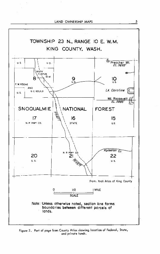
4 MINERAL RIGHTS AND LAND OWNERSHIP IN WASHINGTON
Sections ond parts of sections that are regular in shape are further subdivided by
"quartering" (fig. 1). Areas that are irregular in shape are divided into lots. As an ex
ample, the northwest 40 acres of section 21 as shown in figure l would be described as the
NW:a-NW:a-sec. 21, T. 4N., R. 6E., W.M. Thesectionoranyquarterofasectionmay
also be ..;ivided into "halves." By using this method it is possible to subdivide a section
into a great number of parts and legally describe them.
Of the 66,977 square miles of land in Washington, about 9,500 square miles is
unsurveyed. Th;~nsurveyed lands'ol the State are chiefly in four~· ~1-:-1). These
areas are the most rugged and inaccessible parts of the State. They are the central part of
the Olympic Peninsula, the northern and southern Cascade Mountains, and the northeastern
quarter of Ferry County.
The locations of areas or parcels of land that lie within unsurveyed lands are de
scribed by the "metes and bounds" system. By this method surveys and descriptions of
tracts of land are connected by traverses to landmarks or the closest survey or mineral
monuments.
LAND OWNERSHIP MAPS
Many maps are available that portray topography and the works of man (see
Appendix A, on page 21), but there are few that show land ownership. This is probably
because land ownership is constantly changing, and any such map that is published is soon
out of date.
The most accurate and readily avai I able land ownership maps are the plats main
tained by the County Assessor for each county. On these maps are shown the names of the
owners of the different parcels of land as wel I as the boundaries of the land. As these maps
are maintained for taxation purposes, the status of most lands is kept as accurate and up to
date as possible. The offices of the County Assessor have no land ownership maps for sale,
but their maps are available for public inspection. The office of the County Assessor is
usually in the court house at the county seat (see Appendix B, on page 23).
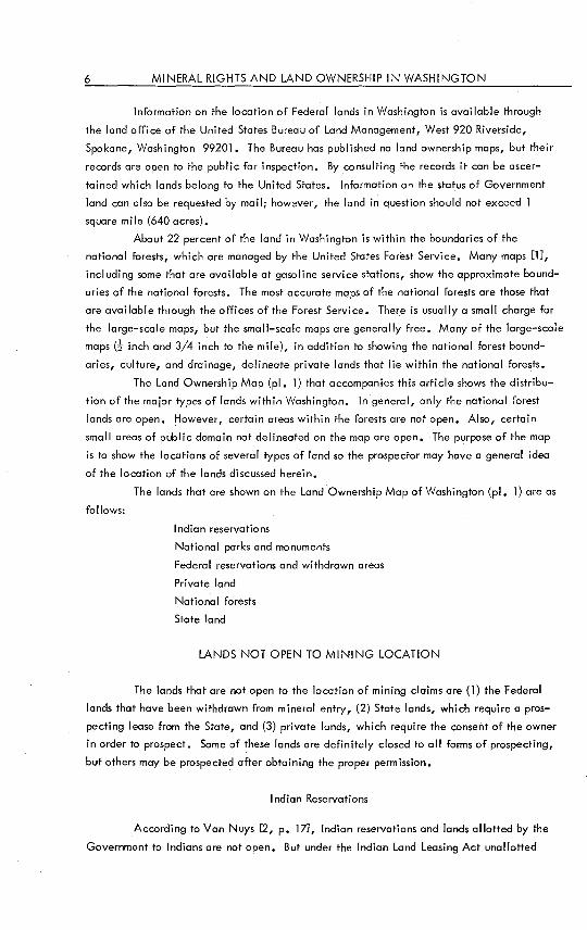
Land ownership maps are also published in the form of County Atlases. The two
most popular County Atlases'in Washington are those published by the Kroll Map Company
(7] and the Metsker Map Company [6]. Each page of the atlas is a township map that is
drafted to a scale of about 2 inches to the mile. In addition to showing the ownership of
lands, the maps also show the culture and drainage. Figure 2 shows part of a township
from a County Atlas. It should be remembered that, because it is impossible to keep the
atlases up to date, they serve as a guide to land ownership but cannot be used as a decisive
authority. Privately owned land in particular should always be rechecked through the
office of the County Assessor. The prices of County Atlases range from $25.00 to $80.00,
depending on the size of the county. However, sheets of individual townships may be pur
chased ot about $1.00 each from the companies that print the atlases. Many of the larger
libraries hove copies of County Atlases for reference.
LAND OWNERSHIP MAPS
TOWNSHIP 23 N., RANGE 10 E. W. M.
KING COUNTY, WASH.
U.S. U.S. Preacher Mt.
F. W. KEENE
AND
U.S. G C. GOULD
9 U.S.
EL.5693'
10 U.S.
Lk. Caroline
I Mt. Roosevelt ~~'
I \
EL. 5885 ~ ~,,, ~,,,
SNOQUALMIE
17 N. P RWY. CO.
20 u. s.
\ NATIONAL -.:I I
0
~ I ~ I 16 -I \
\ STATE \ \ \ \ \
\ \ \ \ I \
N. P RWY. CO.
21 \ ' ~.t.: ',
«"-55
1/2
SCALE
FOREST
15 U.S.
Koleeton Cr.
22 u. s.
From: Kroll Atlas of King County
I MILE
Note: Unless otherwise noted, section line forms boundaries between different parcels of lands.
Figure 2. Part of page from County Atlas showing location of Federal, State, and private lands.
5
6 MINERAL RIGHTS AND LAND OWNERSHIP IN WASHINGTON
Information on the location of Federal lands in Washington is available through
the land office of the United States Bureau of Land Management, West 920 Riverside,
Spokane, Washington 99201. The Bureau has published no land ownership maps, but their
records are open to the public for inspection. By consulting the records it can be ascer
tained which lands belong to the United States. Information on the status of Government
land can also be requested by mail; however, the land in question should not exceed l
square mile (640 acres).
About 22 percent of the land in Washington is within the boundaries of the
national forests, which are managed by the United States Forest Service. Many maps [l],
including some that are available at gasoline service stations, show the approximate bound
aries of the national forests. The most accurate maps of the national forests are those that
are available through the offices of the Forest Service. There is usually a small charge for
the large-scale maps, but the small-scale maps are generally free. Many of the large-scale
maps d inch and 3/4 inch to the mile), in addition to showing the national forest bound
aries, culture, and drainage, delineate private lands that lie within the national forests.
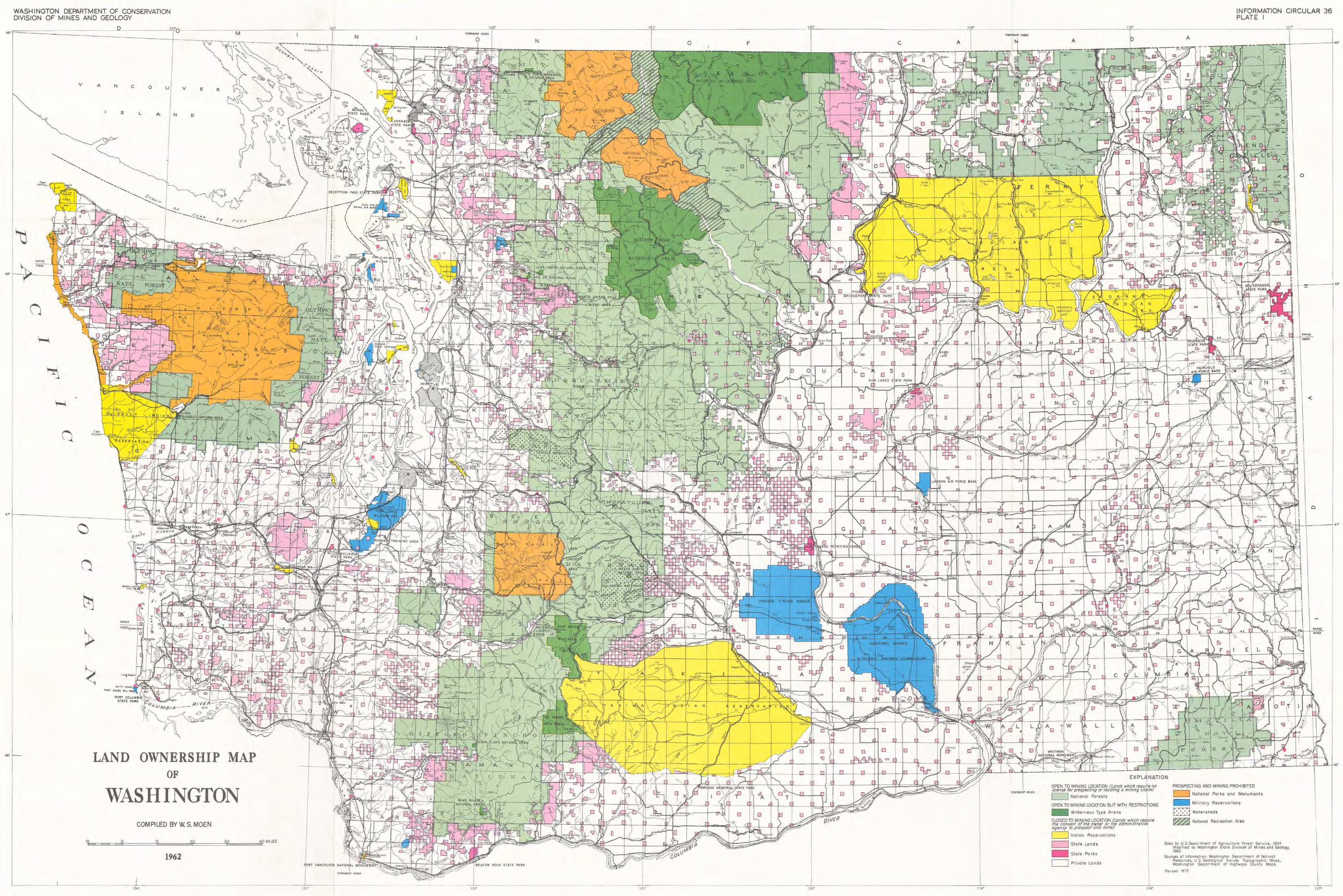
The Land Ownership Map (pl. l) that accompanies this article shows the distribu
tion of the major types of lands within Washington. In general, only the national forest
lands are open. However, certain areas within the forests are not open. Also, certain
small areas of public domain not delineated on the map are open. The purpose of the map
is to show the locations of several types of land so the prospector may have a general idea
of the location of the lands discussed herein.
follows:
The lands that are shown on the Land Ownership Map of Washington (pl. l) are as
Indian reservations
National parks and monuments
Federal reservations and withdrawn areas
Private land
National forests
State land
LANDS NOT OPEN TO MINING LOCATION
The lands that are not open to the location of mining claims are (1) the Federal
lands that have been withdrawn from mineral entry, (2) State lands, which require a pros
pecting lease from the State, and (3) private lands, which require the consent of the owner
in order to prospect. Some of these lands are definitely closed to all forms of prospecting,
but others may be prospected after obtaining the proper permission.
Indian Reservations
According to Van Nuys [2, p. 17], Indian reservations and lands allotted by the
Government to Indians are not open. But under the Indian Land Leasing Act unallotted
LANDS NOT OPEN TO Mlr-llNG LOCATION 7
lands within any Indian reservation, or lands owned by any tribe, group, or band of Indians
under Federal jurisdiction may, by authority of the tribal council or representative, and
with the approval of the Secretary of the Interior, be leased for mining of metalliferous or
nonmetalliferous minerals, including coal, oil, and gas. The secretary may authorize the
head of the Indian Service to approve leases.
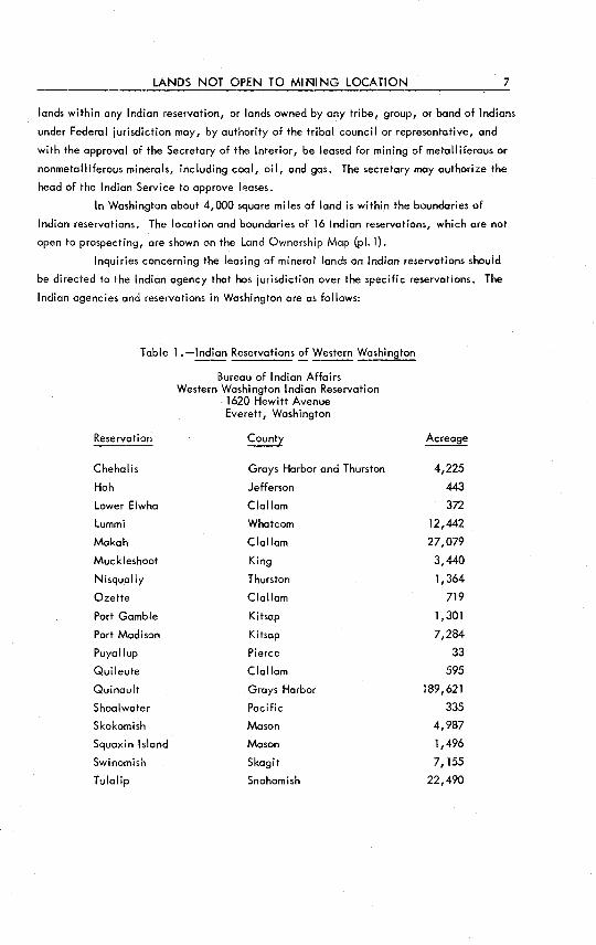
In Washington about 4,000 square miles of land is within the boundaries of
Indian reservations. The location and boundaries of 16 Indian reservations, which are not
open to prospecting, are shown on the Land Ownership Map (pl. l).
Inquiries concerning the leasing of mineral lands on Indian reservations should
be directed to the Indian agency that has jurisdiction over the specific reservations. The
Indian agencies and reservations in Washington are as fol lows:
Table 1.-lndian Reservations~ Western Washington
Bureau of Indian Affairs Western Washington Indian Reservation
1620 Hewitt Avenue Everett, Washington
Reservation County
Chehalis Groys Harbor and Thurston
Hoh Jefferson
Lower Elwha Clallam
Lummi Whatcom
Makah Clallam
Muckleshoot King
Nisqually Thurston
Ozette Clallam
Port Gamble Kitsap
Port Madison Kitsap
Puyallup Pierce
Ouileute Clallam
Ouinault Grays Harbor
Shoalwater Pacific
Skokomish Mason
Squaxin Island Mason
Swinomish Skagit
Tulalip Snohomish
Acreoge
4,225
443
372
12,442
27,079
3,440
1,364
719
1,301
7,284
33
595
189,621
335
4,987
1,496
7,155
22,490

8 MINERAL RIGHTS AND LAND OWNERSHIP IN WASHINGTON
Table 2.- Indian Reservations~ Eastern Washington
Reservation
Colville
Spokane
Yakima
Kalispell
Bureau of Indian Affairs Colville Agency
Nespelem, Washington
County
Okanogan and Ferry
Stevens
Bureau of Indian Affairs Yakima Agency
Toppenish, Washington
Yakima and Klickitat
Bureau of Indian Affairs Northern Idaho Agency
Lapwai, Idaho
Pend Orei I le
National Parks and Monuments
Acreage
1,087,274
141,380
1,134,830
4,629
Mount Rainier National Park, Olympic National Park, North Cascades National
Park, Fort Vancouver National Monument, and Whitman National Monument are not open
to p_rospecting (pl. 1). A valid mining claim existing at the time a national park was created
is protected. The national parks of Washington cover about 2,607 square miles (1,668,480
acres) of land. The Olympic National Park is about 1,388 square miles in area, Mount
Rainier National Park is about 431 square miles, and North Cascades National Park comprises
504,500 acres. The Whitman National Monument, which is in Walla Walla County, and
the Fort Vancouver National Monument, in Clark County, are each less than 1 square mile
in area. These parks and monuments were created to preserve historic and prehistoric land
marks as well as other objects of historic, scer.ic, and scientific interest.
Federal Reservations and Withdrawn Areas
At different times the Federal Government hos withdrawn from the public domain
sections of land to be used for public purposes. There fol lows a brief discussion of a few of
the major land withdrawals:
Military reservations.-Military reservations are not open to prospecting and
mining. The largest areas of this type are the Fort Lewis Military Reservation and the
Rainier Training Area in western Washington and the Yakima Firing Range in eastern Wash
ington (pl. 1). Many smaller military installations are located throughout the State and
LANDS NOT OPEN TO MINING LOCATION 9
are delineated an larger scale maps such as County Atlases or the plats that are maintained
by the counties. Only the larger installations are shown on the Land Ownership Map that
accompanies this article,
Hanford Works, U.S. Atomic Energy Commission.-The Hanford Works in Frank
lin, Benton, and Grant Counties of eastern Washington is closed to prospecting and mining.
The boundary of the Hanford Works is shown on plate l •
Withdrawals adjacent~ State and Federal-aid highways. -Before prospecting on
lands adjacent to State and Federal-aid highways within the national forests, information
on the status of the lands should be obtained from the Forest Service. Van Nuys [2a, p. 15]
makes the following statement in regard to mineral withdrawals adjacent to State and Fed
eral-aid highways:
State and Federal-aid highways which cross national forest lands may or may not be open to mineral entry. In several areas of Washington, such highway rights of way have been withdrawn from mineral entry or location for widths from 200 feet to 500 feet on each side of the highway centerline. In some instances the adjoining lands so withdrawn have been described by legal subdivision. Within the Snoqualmie Poss area, additional lands have been withdrawn for a winter sports area. Also, the U.S. Forest Service has requested the protected withdrawal of certain lands, having scenic, aesthetic, or recreational value, adjacent to some highways traversing national forests,
The two areas of Washington that have been withdrawn are in the Snoqualmie
Pass area of the Cascades and the Sherman Creek area of northern Ferry County. About
5,230 acres of land have been withdrawn at Snoqualmie Pass and 3,800 acres in the Sher
man Creek area.
As to the exact location of the lands included in these withdrawals, inquiry
should be made to the U.S. Bureau of Land Management by specific reference to section,
township, and range of the land in question.
Federa I irrigation and flood-control reservoir sites. -Federa I irrigation and
flood-control reservoir sites on United States public lands are not open to mineral entry.
However, United States Code, Section 662, Title 43 gives the Secretary of the Interior dis
cretionary authority to open any portion of such land that is known or believed to contain
valuable mineral and that has been withdrawn for possible use for construction purposes
under the Federal reclamation laws, but reserving to the United States such rights of way
and other easements as the Secretary deems proper. He may require a separate contract for
such easements for the protection of irrigation projects [2, p. 17].
The Federal irrigation and flood-control reservoir sites are not shown on the
Land Ownership Map (pl. 1). Information regarding the areas withdrawn for these purposes
can be obtained through the U.S. Bureau of Land Management.
Coulee Dam National Recreational Area.-Located in north-central Washington,
Coulee Dam National Recreational Area consists of Franklin D. Roosevelt Lake and feder
ally owned shorelands surrounding it. This recreational area comprises a total of 98,000
acres. Mining operations are not prohibited but are subject to restrictions. Inquiries
regarding prospecting and mining on these lands should be directed to the Coulee Dam
National Recreational Headquarters, Coulee Dam, Washington.
10 MINERAL RIGHTS AND LAND OWNERSHIP IN WASHINGTON
Game sanctuaries.-No game sanctuaries within the national forests of Wash
ington are closed to mineral entry. Inquiries regarding the leasing of lands on State game
refuges or ranges should be directed to the Washington State Department of Game, 600
North Capitol Way, Olympia, Washington.
Privately Owned Lands
Many square miles of land within the State are privately owned and are not
open to the location of mining claims. These lands range in size from small city lots to
the large land holdings of timber and railroad companies. The privately owned lands, for
the most part, fol I outside the boundaries of the national forests. However, some privately
owned lands lie within the national forests. These lands are delineated on some of the
national forest maps and are kept on record by the U, 5, Forest Service.
Although privately owned lands are not open to the location of mining claims,
they may be prospected by obtaining the consent of the individual or company that owns
the mineral rights to the land. The owner of the surface does not necessarily own the min
eral rights, because in the sale of private lands the rights to the minerals are often reserved
by one of the former owners. The mineral owner, his heirs, and assigns, have the legal
right to enter upon the land at any time to prospect and mine the minerals. However, no
damage may be done to permanent improvements on the land. A mineral reservation such
as this does not cover ordinary sand, gravel, or earth. In order to determine who owns the
mineral rights on privately owned lands it is usually necessary to examine the title of the
property.
In some land exchanges al I minerals have been reserved to the United States
upon issuance of the original patents. Where such is the case, a qualified person may
enter the land, prospect for minerals, locate a claim, mine, and remove any minerals ex
cept Mineral Leasing Act minerals. The Mineral Leasing Act minerals (see page 14) are re
served to the United States and may be leased under certain conditions. Any persons enter
ing such lands to prospect must compensate the surface owner for any damages caused there
by to crops or improvements. It is best to secure the written consent or a waiver from the
land owner. If consent is not given, entry may be obtained by posting a bond, the amount
of which will be determined by the U.S. Bureau of Land Management, after which the land
can be entered upon and mining operations commenced.
Lands containing deposits reserved to the United States ore chiefly: (1) lands
classified or withdrawn as coal lands and patented thereafter under nonmineral land laws
subsequent to March 3, 1909, or (2) lands classified or withdrawn for their contained phos
phate, nitrate, potash, oil, gas, and asphaltic minerals, or valuable for such deposits and
thereafter patented under the nonmineral land laws, (for example, homesteads) subsequent
to July 17, 1914. Prior to December 29, 1916, most patents that were issued under the
agricultural laws included the minerals, so that the minerals in the land belonged to the
patentee or holder of the agricultural patent,
Whether or not a given tract of land has minerals reserved to the United States
can be ascertained by searching an abstract of title, by examining the county claim-of-title
LANDS NOT OPEN TO MINING LOCATION 11
records, or by inquiring of the U.S. Bureau of Land Management.
Lands containing mineral deposits reserved to the State are all lands which were
sold by the State after 1907.
Beds ~ non-navigable streams and lakes. -Non-navigable stream and lake beds
on private property are not open. They must be leased from the owner or owners ·of the
land that surrounds the body of water. Navigable streams and lake beds are owned by the
State and are subject to mineral leasing from the State (see page 12).
Railroad lands.-Railroad lands are private lands and are not open to the loca
tion of mining claims. In the past, railroad land grants and indemnity lands were either
patented or unpatented. The unpatented lands were open for prospecting. However, under
the Transportation Act of 1940, the railroads were granted patents on all their lands, and
no rai I road lands are now open. Should anyone desire to prospect or mine on rai I road land,
he should negotiate with the railroad company the same as with the owner of any other
privately owned land.
The general distribution of privately owned land in Washington is shown on the
Land Ownership Map (pl. l). As pointed out in the section on land ownership maps (see
page 4), in order to obtain the exact location of privately owned lands it is best to consult
a County Atlas of the plats maintained by the county. In many areas the boundary lines of
these lands are difficult, if not impossible, to trace and may require the services of a sur
veyor to relocate them.
County-Owned Lands
Lands owned by a county may be leased for prospecting and mining through its
county commissioners. If the lease covers land previously sold by the county, but in which
the county reserved the minerals, the lessee must pay the surface owner for damages to the
surface.
State-Owned Lands
Approximately 7 percent (3,000,000 acres) of the total land area of Washington
is owned by the State. The distribution of most of the State lands is shown on plate l. No
attempt has been made to show al I the State lands on this Land Ownership Map. Only lands
in tracts of 320 acres or more that are administered by the Department of Natural Resources,
and State parks in excess of 500 acres are shown on the map. Some tracts of private land,
which are too small to delineate, are included within the State lands. State-owned public
lands include school lands (usually sections 16 and 36 of every township), university lands,
state parks, state forest lands, deeded lands, institutional lands, highway rights of way,
lands under the jurisdiction of the Game and Fisheries departments, tidelands, offshore
lands, and the beds of navigable streams and lakes.
Mining locations may not be made upon lands that belong to the State. How
ever, most State lands may be leased for prospecting and mining purposes. Most of the
State land shown on the Land Ownership Map (pl. l) is subject to the mineral leasing

12 MINERAL RIGHTS AND LAND OWNERSHIP IN WASHINGTON
regulations of the State. The State Commissioner of Public Lands administers the leasing of
State-owned mineral lands and deposits. Inquiries regarding the leasing of State lands
should be directed to the following address: State Commissioner of Public Lands, Depart
ment of Natural Resources, Olympia, Washington 98504.
There are three types of State mineral leases: (1) leases for gold, copper,
silver, lead, cinnabar, or other valuable minerals; (2) leases for oil and gas; and (3) leases
for cool. Timber, sand, gravel, stone, and other like materials on State land may be sold,
and in some cases leased, by the Commissioner of Public Lands at their appraised value.
Full details on the leasing of State-owned mineral lands are given on page 108 of "An Out
line of Mining Laws of the State of Washington" [2].
There is no way of determining, from an examination of the surface, which
State lands are open for leasing. As leases for minerals on State lands must be legal
subdivisions of the United States survey, the lessee is not required to establish marked
boundaries as in locating mining claims on open Federal land. For this reason the only
way of knowing whether a certain section of State land is available for leasing is to inquire
of the office of the State Commissioner of Public Lands.
State parks.-The Washington State park system comprises 167 parks and additional
tracts, which cover more than 76,000 acres. Individual State parks range in size from 3
acres at Donovan State Park in Skagit County to 24,330 acres at Mount Spokane State Park
in Spokane County. Of the 167 State parks, only those larger than 500 acres are outlined
on the Land Ownership Map (pl. 1). The smaller parks are shown as dots.
Certain areas within some of the parks are open for leasing of mineral lands.
Inquiries regarding the leasing of land within State parks should be directed to the Wash
ington State Parks and Recreation Commission, Olympia, Washington 98504.
Beds~ navigable and certain non-navigable waters.- Whereas the beds of non
navigable streams and lakes on public domain and in national forests are open to mineral
entry, on State-owned lands they are not open but are subject to mineral leasing from the
State. The beds of al I inland navigable streams and lakes, whether on State, Federal,
private, or any other type of land, are owned by the State and are subject to the mineral
leasing laws of the State.
Tidelands, backshore lands, and offshore lands.-The State owns al I tidelands
unless they have been granted away and are now privately owned. This includes the land
that lies between the meander line and the mean low tide line.

LANDS NOT OPEN TO MINING LOCATION 13
The land shoreward from the meander line (usually the mean, or average, high
tide line) is the uplands. Whether uplands ore open to prospecting or not depends on the
ownership. Hence, public domain would be open, whereas State and privately owned
land would not. Accreted land, or land added to the original property by natural forces
such as stream deposition, ordinarily belongs to the owner of the adjacent land.
Offshore lands extend 3 nautical miles seaward from the mean low tide line.
These lands belong to the State and are subject to mineral leasing from the State. The
outer continental shelf lands lie beyond the State offshore lands. For information regard
ing these lands see page 15.
LANDS OPEN TO MINING LOCATION
The word "open" as used in this circular refers to lands that ore open to pros
pecting, location, mining, and patenting of lode or placer mining claims. If the land is
open, no permit or license is required to enter, prospect, or locate a mineral claim. The
only fee required is the charge made by the County Recorder to record a mining claim. It
is usually about $2.00.
The U.S. Government does not publish maps showing which Federal lands are
open for mineral entry. In general, public domain and the national forests'-offer the largest
area of lands open to prospecting within the State. However, there are restrictions even
on parts of this land, such as areas that are withdrawn from mineral entry, wilderness-type
areas, and areas that are open only for certain minerals.
Pub! ic Domain
Public domain, which is land belonging to the United States, is open. In Wash
ington, each month, title to a few thousand acres of land passes from the United States to
others, the recipient of the largest amount being the State of Washington. At present
only a few hundred square miles of public domain remains. This land represents unallocated
lands, which are subject to sale or other disposition under the general laws of the United
States.
The public domain is managed by the U.S. Bureau of Land Management. They
publish no maps that show the locations of these lands. However, the Bureau of Land
Management maintains plats and records of all the public domain. The plats, which are
in the form of township maps, show vacant lands and various types of classified, reserved,
and appropriated lands. They also show lands that are reserved for certain minerals, oil
and gas, and power sites. The Bureau also keeps records of all applications for patents as
well as of patents that have been issued for mining claims.
All records of the Bureau of Land Management are open to the public for refer
ence. The address of the office that manages the public domain within Washington is:
14 MINERAL RIGHTS AND LAND OWNERSHIP IN WASHINGTON
U.S. Bureau of Land Management, Washington Land Office, West 920 Riverside, Spokane,
Washington 99201,
Some of the lands that lie within the public domain as well as the laws that
affect the mineral deposits on these lands are discussed briefly in the following paragraphs:
United States Leasing Act mineral lands.-The United States Mineral Leasing
Acts of 1920 and 1927 authorized the United States to lease its public lands that contain
coal, oil, oil shale, gas, phosphate, and sodium and potassium compounds. These acts
prohibited the location of mining claims on Leasing Act mineral lands; the lands could
only be leased from the Government.
Public Low 585, which was passed in 1954, opened the Leasing Act lands for
minerals other than the Leasing Act minerals. Thus, all such lands are now open to pros
pecting and mining (of all but the Leasing Act minerals) under the general mining laws of
the United States. However, the same land is also open to leasing (of Leasing Act min
erals) under the Mineral Leasing law. Where Leasing Act minerals are reserved to the
United States, the claim owner in the course of his operations must not damage the reserved
mineral deposits. Also, the Leasing Act lessee shall conduct his operations so as not to
interfere with the surface or underground workings of patented or unpatented mining claims
[2a, p. 11]. Lands are not subject to the terms of the Leasing Act when they lie in incor
porated cities and towns, national parks and monuments, and military and Indian reserva
tions.
Federal power sites.- United States Public Law 359, passed in 1955, opened to
entry for location and patent of mining claims all public lands belonging to the United
States that were thereafter withdrawn or reserved for power sites or power development.
However, a mining claim may not be located within a Federal power site in which a power
project is being operated or is being constructed under the Federal Power Act. Also, any
land that is under examination by any prospective licensee of the Federal Power Commission
is not open for the location of a mining claim [2a, p.141.
Under the Federal Power Act, Federal hydroelectric power sites or power projects
that were established prior to August 11, 1955, are not open to prospecting or mining. How
ever, the Federal Power Commission can open any portion of the sites or projects, provided
the sites are not damaged for power development purposes by mining operations. The United
States and its Ii censees have the right at any time thereafter to reoccupy or use any part of
such opened land without compensation to the miner (or entryman) except for damage to
crops, bui !dings, and improvements.
Grazing districts.- Grazing districts and areas occupied by grazing permittees
within the public domain are open. The miner is not obligated in any way to such permit
tees for damage to their grazing operations.
The Taylor Grazing Act of June 28, 1934, created grazing districts on United
States vacant, unreserved, and unappropriated pub Ii c lands. However, th is act provides
the prospector the following allowance:
The right to prospect, locate, and patent mining claims, also to lease lands containing U.S. Mineral Leasing Act minerals without regard to classification and without restriction or limitation by any provision in the Act (Taylor Grazing Act) [2, p. 191.

LANDS OPEN TO MINING LOCATION 15
The purpose of the act is to promote the highest use of public lands.
United States public land withdrawals.-Any permanent land withdrawals are
not open to metalliferous and nonmetalliferous mining. However, if the withdrawal con
verted the land into a class that is already open, such as a national forest, it is open. Tem
porarily withdrawn pub I ic lands are open to metal I iferous but not nonmetal I iferous mining.
Any temporary withdrawal remains in effect unti I revoked by the President or by Congress
[2, p. 20].
Beds~ non-navigable waters. -Beds of non-navigable waters are open if they
are on United States public land that is open. This applies to the minerals on or under the
bottom of the water and not to the rights to appropriate and use the water. The State owns
the beds of all inland navigable streams and lakes, and tidelands. Hence, the minerals are
subject to leasing from the State.
There is no definite rule as to what distinguishes a navigable stream from a non
navigable stream. In general, those streams, lakes, and coastlines that have been mean
dered (government surveyed} are considered to be navigable waters.
Outer continental shelf lands.-The outer continental shelf lands lie between
the outer limits of the State's offshore lands (3 nautical miles seaward from the mean low
tide line) and the 12-mile offshore line, which marks the boundary of the United States.
The outer continental shelf lands are public domain, The contained minerals
are subject to the United States mineral leasing and mining laws as administered by the
Bureau of Land Management [5 l. It is evident from the foregoing discussion that public lands are subject to many
regulations and laws that determine whether or not they are open for prospecting. Before
expending time and money prospecting on any particular parcel of land in the public domain
it is best to inquire through the U. S, Bureau of Land Management as to the status of the
mineral rights on this land.
National Forests
The national forests of Washington constitute the largest land areos open for pros
pecting. In Washington there are 7 complete national forests and 2 fractional parts. The
total land area of the national forests within the State is approximately 15,093 square miles,
which is about 22 percent of the total land area of Washington. The boundaries of these
forests are shown on the Land Ownership Map (pl. l) that accompanies this circular.
The U.S. Forest Service, by act of Congress, is given exclusive control over the
timber and the surface use of the national forest lands. In addition, the Forest Service is
authorized to make general regulations that relate mainly to trails, rights of way, and
forest protection. The U, S. Bureau of Land Management has been given exclusive control
of surveying, prospecting, locating, and patenting of national forest lands. Persons enter
ing the national forests for any purpose must comply with Federal, State, county, and local
rules and regulations of the forests.
16 MINERAL RIGHTS AND LAND OWNERSHIP IN WASHINGTON
The national forests of Washington and the towns in which the supervisors' of
fices are located are as fol lows:
Table 3.-National Forests~ Washington
Forest Supervisor's office
Chelan Okanogan
Colville Colville
Gifford Pinchot Vancouver
Kaniksu Sand Point, Idaho
Mount Baker Bellingham
Olympic Olympia
Snoqualmie Seattle
Umatilla Pendleton, Oregon
Wenatchee Wenatchee
Within the boundaries of the national forests there are several different types of
lands, some of which are open and others of which are closed to prospecting and mining.
These types include lands withdrawn from mineral entry, wilderness-type areas, patented
lands, unpatented mining claims, watersheds, beds of navigable and non-navigable waters,
State lands, and limited areas.
Lands withdrawn from mineral entry. -Some lands within the national forests are
withdrawn from mineral entry and therefore are not open, These lands comprise less than
5 percent (453,093 acres) of the total land area of the forests. The following table contains
the various types of withdrawn land as well as the areas (in acres) of land involved in the
withdrawals.
Table 4. -Withdrawn Lands Within the National Forests
~ Washington
Reclamation
Power
Flood control
Federal game refuges
Mi I itary reservations
Administrative sites
Public service sites and recreational areas
Experi men ta I forests and refuges
Road zones and rights of way
Watersheds
Other
Total
Area (acres)
31,130
304,179
0
0
7
6,356
8,945
0
6,256
96,000
220
453,093

LANDS OPEN TO MINING LOCATION 17
The Forest Service does not have available for distribution maps showing the
location of the withdrawn lands. However, regiona I and district offices of the Forest
Service maintain up-to-date plat and tabular records of these lands that can be consulted.
The regional office for all the national forests of Washington except the part of
the Kaniksu National Forest in Pend Oreille County and the part of the Colville National
Forest in Ferry and Stevens Counties is: U.S. Department of Agriculture, Forest Service,
Pacific Northwest Region, P.O. Box 3141, Portland, Oregon 97208,
The regional office for part of the Colville National Forest and the part of the
Kaniksu National Forest in Washington is: U.S. Department of Agriculture, Forest Service,
Northern Region, Federal Building, Missoula, Montana 59801.
Wilderness-Type areas.- Certain areas within the national forests are set aside
to preserve their exceptional scenery. In Washington there are four such areas, as shown
on the Land Ownership Map (pl. 1). The names and sizes of the areas and the national
forests in which they are located are as follows:
Table 5.-Wilderness-Type Areas <:_!'Washington
Name Size (acres) National forest
Pasayten Wilderness Area 520,000 Mount Baker and Okanogan
Glacier Peak Wilderness 468,105 Mount Baker and Area Wenatchee
Goat Rocks Wild Area 82,680 Gifford Pi nchot
Mount Adams Wild Area 42,411 Gifford Pi nchot
Total 1,113,196
The wilderness-type areas are open to prospecting and mining. However, moving
about in these areas is restricted to foot or horse travel, as the usual policy of the Forest
Service is to prohibit construction of roads in these areas. This regulation also applies to
smaller areas within the national forests that are designated as natural areas. The natural
areas of Washington, their sizes, and the national forests in which they are located are as
follows:
Table 6.- Natural Areas <:[Washington
Natura I area Size (acres) Nationa I forest
Cedar Flats 680 Gifford Pinchot
Lake 22 790 Mount Baker
Long Creek 640 Mount Baker
Meeks Table 68 Snoqualmie
North Fork Nooksack 1,495 Mount Baker
Quinault 1,435 Olympic
Wind River 1,180 Gifford Pinchot
Total 6,288
18 MINERAL RIGHTS AND LAND OWNERSHIP IN WASHINGTON
Limited ~.-In 1946, four areas within the national forests of Washington
were identified by the Forest Service as possessing special recreational values. The Forest
Service cannot establish these areas as specific recreational areas unti I they have been
given a special study. If found to be of recreational value, they may be classified as
wilderness-type areas. If they are not classified as such, they will be restored to their
original notional forest status. The Glacier Peak Wilderness Area, which was established
in 1960, was formerly a limited area.
Although limited areas are not closed to logging operations, road building, and
prospecting and mining, occupancy requires the prior approval of th-= Forest Service.
Before undertaking work in limited areas, one should contact the supervisor of the national
forest in which the areas are located"
The limited areas of Washington, the national forests in which they are located,
and their gross areas are as follows:
Limited area
Alpine Lakes
Cougar Lake
Table 7. -Limited Areas of Washington
Size (acres)
256,000
90,000
Monte Cristo Peak 11,500
10,000
367,500
Packwood
Total
National forest
Snoqualmie and Wenatchee
Snoqualmie and Gifford Pinchot
Snoqualmie and Mount Baker
Gifford Pinchot
Patented landso -The national forests contain areas of patented land owned by
the Northern Pacific Roi lway Company, the Northwestern Improvement Company (its sub
sidiary), timber companies, and individualso These patented lands are private property
and are not open to prospecting and mining.
The location of patented lands within the boundaries of the national forests is
shown on some of the large-scale maps compiled by the Forest Service. Inasmuch as pat
ented lands are subject to county taxes, they are also shown on the plats that are maintained
by the County Assessors of the counties in which these lands are located.
Unpatented mining claimso-Valid unpatented mining claims in the national
forests are not open. However, if it can be proved that the claims have been abandoned
or are in default of assessment work, they are open for relocation.
The Forest Service or the office of the County Recorder in which the mining
claim was recorded do not maintain maps that show the location of unpatented mining claimso
By consulting the mining claims records at the office of the County Recorder, however, it
should be possible to determine the approximate location of a mining claim. Unfortunately,
the locations of many claims are so poorly described that it is impossible to determine their
position with any certainty.
LANDS OPEN TO MINING LOCATION 19
By State and Federal mining laws the locator is required to mark the boundaries
of a claim so that they con be readily traced. While prospecting, if an individual finds
a boundary line of a claim, an examination of the area should disclose the discovery site.
At the discovery site there should be a notice that includes the name of the claim and
locator, and the date of discovery. If 90 days hove elapsed since the discovery, somewhere
within the boundaries of the claim there should be a 10-foot discovery shaft or its equiva
lent work. Recent work in the area is sometimes a sign that the claim is being worked.
However, in a group of contiguous claims there may be no signs of work on some claims,
as the law permits all the assessment work to be done on any one claim.
Watersheds.-Watersheds ore catchment areas or basins that collect a water
supply: Some watersheds ore closed to mining or simi lor operations that might pol lute the
waters. Within the national forests of Washington there ore two watersheds that have been
withdrawn from mineral entry. They are the Cedar River watershed, for the city of Seattle,
and the Rattlesnake Creek watershed, for the city of Yakima. These watersheds ore del ine
ated on the Land Ownership Mop (pl. 1). A total of 96,000 acres of notional forest land
has been withdrawn for these watersheds. Parts of both watersheds lie outside the boundary
of the national forest. These ports are also closed to prospecting, inasmuch as the land is
privately owned. Other watersheds hove been established in the national forests. Although
they are subject to certain rules and regulations, they have not been withdrawn from mineral
entry.
Beds~ navigable and non-navigable woters.-The beds of non-navigable waters
within the national forest are open to prospecting and mining. This applies to the minerals
on or under the bottom of the water and not to the rights to appropriate and use the water.
A holder of a mining claim within the national forest who desires to appropriate water from
a stream or lake within the national forest must secure a permit from the Forest Service and
another from the State Supervisor of Water Resources.
Navigable stream and lake beds within the notional forest, regardless of who
owns the surrounding lands, belong to the State and are not open. However, they are sub
ject to the mineral leasing laws of the State (see page 12).
State lands. -When the State was created, Congress granted to it, for the support
of the public schools, sections 16 and 36 of every township as soon as the land was surveyed.
Indemnity lands were granted in lieu of sections or parts of sections already disposed of or
sold. Within the national forests there are many surveyed school lands. These lands belong
to the State and ore not open to prospecting and mining, but may be leased from the State.
The distribution of the State lands within the national forests is shown on the Land Owner
ship Mop (pl. 1).
Even though questions might arise over which lands within the national forests are
open to prospecting and mining, the prospector will be faced with fewer problems when pros
pecting within the national forests than on most other lands. As mentioned before, the lands
that are withdrawn from mineral entry comprise less than 5 percent of the total area of the
national forests of the State. The locations of these areas ore readily available from the
Forest Service.
20 MINERAL RIGHTS AND LAND OWNERSHIP IN WASHINGTON
SELECTED REFERENCES
Publications available from Department of Natural Resources, Division of Mines and
Geology, Olympia, Washington 98504
[1] Selected Washington maps and their sources (mimeo). Free
[2] An outline of mining laws of the State of Washington (Bulletin 41),
by M. H. Van Nuys, 142 p., 1953. Out of print.
[2a] Supplement of Bulletin 41, 26 p., 1956. Out of print.
[2b] Mining Claims-Questions and Answers.
Publications available from Superintendent of Documents, Government Printing Office,
Washington, D. C. 20402.
[3] Lode and placer mining regulations: U.S. Bureau of Land Management
Circular 1941, 26 p., 1955. (Part 185, Title 43, Code of Federal
Regulations). Free
[4] Regulations for oil and gas leasing on Federal public lands: U.S. Bureau of
Land Management Circular 2037, 13 p., 1960. (Part 192, Title 43,
Code of Federal Regulations). Free
[5] Leasing and operaHng regulations for the submerged lands of the outer
continental shelf: U.S. Department of the Interior, 44 p., undated.
(Part 250, oil and gas, Title 30, and Part 20, mineral deposits,
Title 43, Code of Federal Regulations). Free
Publications available from private firms:
[6] Metsker County Atlases: Metsker Maps, 1222 Third Avenue, Seattle,
Washington 98101; 111 South 10th Street, Tacoma, Washington 98402.
[7J Kroll County Atlases: Kroll Map Company, Inc., 816 Second Avenue,
Seattle, Washington 98104.
Note: Prices of atlases vary and are available upon request from the above companies.

APPENDIXES 21
APPENDIX A
SELECTED WASHINGTON MAPS AND THEIR SOURCES
Topographic quadrangle maps: ?~-minute, scale 1:24,000 (1 inch= 2,000 ft.)
or scale, 1:31,680 (1 inch = 1 mile). 15-minute, scale 1:62,500 (1 inch= approximately
l mile}. 30-minute, scale 1:125,000 (1 inch= approximately 2 miles). Available from
the Distribution Section, U.S. Geological Survey, Federal Center, Denver, Colorado 80225.
Price, 75 cents per sheet. Also available at larger stationery stores at a slightly higher
cost.
Index~ Topographic Mapping ~ Washington: This shows the areas in Washing
ton for which topographic quadrangle maps are available. May be obtained free from the
Distribution Section, U.S. Geological Survey, Federal Center, Denver, Colorado 80225.
Contour Map~ the State~ Washington: 1,000-ft. contour intervals, scale
1:500,000, Six sheets (Sectional Aeronautical Charts} are necessary for complete coverage
of the State. These are: Bellingham, Kootenai, La Grande, Portland, Seattle, and
Spokane. They are available for 25 cents a sheet from the U.S. Coast and Geodetic Survey,
Washington Science Center, Rockville, Maryland 20852. Aeronautical maps at scales of
1:2,000,000, 1:1,000,000, 1:250,000, and 1:125,000 are also available, A catalog of
nautical and aeronautical charts is available from the U.S. Coast ond Geodetic Survey.
U.S. Army Map Service Topographic Maps _0 Washington: (Sheets available:
Sandpoint, Spokane, Pullman, Okanogan, Ritzville, Walla Walla, Pendleton, Concrete,
Wenatchee, Yakima, The Dalles, Victoria, Seattle, Hoquiam, Portland, Copolis Beach).
Scale 1:250,000 (1 inch= 4 miles). Available from the U.S. Army Map Service, Washing
ton, DC 20242, Also available are maps on a scole of 1:100,000 covering more of the
State, An index to Army Map Service maps may be obtained from The Commanding Officer,
Army Map Service, Corps of Engineers, U.S. Army, Washington, DC 20315,
Plastic relief models~ 2-degree quadrangles ~ Washington: These relief models,
at a scale of 1:250,000, depict the same areas as shown by the U.S. Army Map Service
topographic maps described above. Available from Hubbard, P, 0. Box 105, Northbrook,
Illinois 60062, at a price of $9.95 per quadrangle, plus $1 for handling and postage regardless
of the number of maps ordered.
U.S. Geological Survey Planimetri c ~£!Washington: Covers the entire state,
scale 1:100,000 (1 inch= 16 miles}. One color. Available from the Distribution Section,
U.S. Geological Survey, Federal Center, Denver, Colorado 80225, or from the U.S.
Geological Survey, Washington, DC 20242. Also available from these sources is a
similar map on a scale of 1:500,000 (1 inch= 8 miles}.
U.S. Forest Service Map~ Washington: This is a planimetric map composed of
4 sheets- N~, SE;\:, NW;\:, and SW;\:, on a scale of 1:253,440 (1 inch= 4 miles}. Avail
able from the U.S. Forest Service, Washington, DC 20250,
22 MINERAL RIGHTS AND LAND OWNERSHIP IN WASHINGTON
Maps~ National Forests: (Chelan, Colville, Gifford Pinchot, Mount Baker,
Olympia, Snoqualmie, and Wenatchee National Forests). Planimetric maps available
from the U.S. Forest Service, P.O. Box 3141, Portland, Oregon 97208. Prices vary
according to scale of map.
Highway Map of Washington: This shows primary and secondary highways.
Available from the State Department of Highways, Olympia, Washington. Also avail
able from this source is a State of Washington index map that shows the sheets available
of the Department of Highways county maps.
County Planimetric Maps: Scale, 1 inch= 1 mile. Up-to-date maps showing
land grid, towns, rivers, and highways. All roads, both primary and secondary, are
shown. Also available at a scale of 1 inch = 2 miles. May be purchased from the Wash
ington State Department of Highways, Highway Administration Building, Olympia,
Washington 98504.
County Planimetric Maps: Scale, 1 inch= 2 miles. Less detailed and on a
larger scale than U.S. Geological Survey topographic quadrangle maps. Available at
a price of $1.25 from Metsker Maps, 1222 Third Street, Seattle, Washington 98101, or
111 South 10th, Tacoma, Washington 98402. Also available from this source are maps
showing land ownership.
Aerial Mosaic Index: Shows all areas for which aerial mosaics or photomaps are
known to have been compiled for or by Federal, State, or commercial agencies. Avail
able from the Map Information Office, U.S. Geological Survey, Washington, DC 20242.
Status~ Aerial Photography: Shows the areas covered by photographs and the
agency that holds the photographs. This is available from The Map Information Office,
U.S. Geological Survey, Washington, DC 20242.
Landform ~~the Northwest: This map shows topography by shading. Avail
able from Erwin Raisz, Cambridge, Massachusetts 02135, and University Book Store,
4326 University Way, Seattle, Washington 98105. Scale, 1 inch = about 20 miles.
Charts showing water depths and surface contours on adjacent lands: Available
for the Pacific Coast and some harbors and rivers in Washington. Practically all charts are
drawn on decimal scale, generally from 1:10,000 to 1:80,000. Available from the U.S.
Coast and Geodetic Survey, Washington Science Center, Rockville, Maryland 20852.
Maps and Mapping Agencies 0_ Washington State: This is a University of Wash
ington Bachelor of Arts Thesis, Department of Geography, by Ralph Edward Black and
Howard Edward Vogel. All known maps dealing with the State of Washington are listed,
and the names of the distributing agencies are also given. It may be consulted in the
University of Washington Library, or it may be borrowed through interlibrary loan.

APPENDIX B
LOCATION OF COUNTY SEATS IN WASHINGTON
County seat
Adams -------------------------------------------------------- Ri tzvi I le
Asotin -------------------------------------------------------- Asotin Benton-------------------------------------------------------- Prosser
Chelan------------------------------------------------------- Wenatchee
Clallam------------------------------------------------------- Part Angeles
Clark--------------------------------------------------------- Vancouver
Columbia ----------------------------------------------------- Dayton
Cowlitz ------------------------------------------------------- Kelso
Douglas------------------------------------------------------- Watervi I le
Ferry --------------------------------------------------------- Republic
Frank Ii n ------------------------------------------------------ Pasco
Garfield ------------------------------------------------------ Pomeroy
Grant-------------------------------------------------------- Ephrata
23
Grays Harbor -------------------------------------------------- Montesano
Island -------------------------------------------------------- Coupevi I le
Jefferson ----------------------------------------------------- Port Townsend
King--------------------------------------------------------- Seattle
Kitsap -------------------------------------------------------- Port Ore hard
Kittitas ------------------------------------------------------- Ellensburg
Klickitat------------------------------------------------------ Goldendale
Lewis --------------------------------------------------------- C heha Ii s
Lincoln ------------------------------------------------------- Davenport
Mason-------------------------------------------------------- Shelton
Okanogan----------------------------------------------------- Okanogan
Pacific ------------------------------------------------------- South Bend
Pend Ore i I le -------------------------------------------------- Newport
Pierce-------------------------------------------------------- Tacoma
San Juan ----------------------------------------------------- Friday Harbor
Skagit -------------------------------------------------------- Mount Vernon Skamania----------------------------------------------------- Stevenson
Snohomish----------------------------------------------------- Everett
Spokane------------------------------------------------------ Spokane
Stevens ------------------------------------------------------- Col vi I le
Thurston ------------------------------------------------------ Olympia
Wahkiakum --------------------------------------------------- Cathlamet
W.al la Walla -------------------------------------------------- Wa I la Wal la
Whatcom ------------------------------------------------------ Be 11 i ngham
Whitman ------------------------------------------------------ Colfax Yakima------------------------------------------------------- Yakima
24
ADDENDA
(page 12, shaded paragraph, amended by Chapter 56, Laws of 1965)
There is no objection to a person examining State lands in order to determine which
area he might want to lease. However, after an area has been selected, a prospecting
lease or mining contract is required. Prospecting leases are for 2 years. The area covered
by a lease may not be less than 40 acres (less if a legal government lot) or more than 640
acres (more if a -legal section). A rental of 25 cents per acre per year is required. A
prospecting lease may be converted to a mining contract; however, the conversion must
be initiated prior to the expiration of the prospecting lease. The lessee must submit proof
of development work on the property in the amount of $1.25 per acre per year in order to
convert a prospecting lease to a mining contract.
A mining contract is required when the actual mining commences. The first 4
years of a contract are referred to as the exploration or prospecting period. The rental for
the first 2 years is at the rate of 25 cents per acre per year. For the 3rd and 4th years the
rental is 50 cents per acre per year. Time expended on a prospecting lease is deducted from
the exploration or prospecting period of the contract. To retain the contract past the 4th
year, the lessee must submit evidence of development work in the amount of $1.25 per
acre per year. The 5th through the 20th year requires a minimum annual royalty of $2.50
per acre, and annual development work in the amount of $2.50 per acre. A standard
royalty of 3 percent is required; however, the Commissioner of Public Lands may establish
a different rate for specific minerals.

OVERLAY TO INFORMATION CIRCULAR 36 - PLATE I
MINERAL RIGHTS ANO LAND OWNERSHIP IN WASHINGTON
" I I
MT. ADAMS i
WILOERN~ESS ,-~, I I
r- I r I I I [ ___ _
YAKIMA INOIAN RESERVATION
', ' ", ',,
46° 4-----------------~-~ 46°
122° 121°
NOTE: This overlay st-iows the new boundary of a recent addition lo the Yakima Indian Reservation in 'the vicinity of Mt. Adams. The new addition is shown in a solid line.
WASHINGTON DEPARTMENT OF CONSERVATION DIVISION OF MINES AND GEOLOGY INFORMATION CIRCULAR 36 PLATE I
... r==============:;:===:::Q::::========:"1·~o=~~~~~~~~~~~~~~~~~~~~~M~:::=---------,-------""r''"------------------------,------'"p'C" ___________________________ _!!,,µ•c· ___________________________ ,,,T.'-------------- - -------------'"r''"----------------------------'"'~··:.._ __________________________ _J,~'''"'-------~ N "'"""'"'..,.,. 6 '°""""" '"DU A A
C A N
...
,_ , ...... ,
\-I,
()
V
a
A N C
s L
INC~! It.
"°''""<•d , .. ,. """' ~ .....
a
FOIIT COUJ/1191 STATE PU~
0 u V ' R
A N D
LAND OWNERSHIP OF
MAP
WASHINGTON COMPILED BY W. S. MOEN
"====="====="'ee====""',D'======'~D""====~·Mo MI LES
1962
124"
YAKI A Flltl
• D
D D D
'·
121• 122• 1~ 1·
" ~ D
D D s
'" 0 0
" w,...,,nt"
"' 11cE us j " ... 0 D
"
D D "
G A
0 " ,
0 D ~ D 0
c.o
• . ' D D D ~ , .. , .. "
0
D
~ N K
D D D D D ioM,.., [J•
~ ~
D
.. .. -
.. rnvtP
l '
,.
• D
'•
''"''"'
0 0 0
~
• -e
a
D
·-D .
, I L ' A . ·1~
' "•· •. •W L
-~ b[d ~ i'; M~,\ D n ~~
' ,~"·"'"" ,..,,,
' - " Ii -----EXPL NATION
OPEN TO MINING L,QGATION (UJnds wh/Ch requ1 no license for prospeclrnq or tocolinq a mining cl ·m;
c=J National Forests
OPEN TO MINING LOCAJION BUT WITH RESTRIC IONS
- Wildernes~ Type Areas
CLOSED TO MIN ING LOCATION /lends which req ire !h8 consent of !he owner or the odmims/raliv . agency to prospect and m,ne/
~ lndion Reservations
~ State Lands
- State Porks
~ Private Lands
PROSPECTtNG ANO MINING PROHIBITED
c::::::::J Notional Pork,. and Monuments
- MIiitary Reservations
~ Watersheds
~ Notional Recreation Area
Base by _US Deporlment of Agr,culturo Fo,esr Sorvoco, 1934 ~tf,ed by Wcshington Stole Di• isi on or Mines end Geology.
Sou,ces of ln/ormot,on . WOshington Depo,1men1 of Natural Resources, U. S. Geolog,col Sur.ey Topographic Mops, Wo,hongton Deportmenl of H,ghwoy, County Mops.
flev.,,o l':!72
-----------------'---------~- -119" 118"
0
------a···
.. -·-
<
0
.,.
.. -C. ··-
I l7"