Indonesian Forest Resource Monitoring - … · Indonesian Forest Resource Monitoring . ... 2008,...
9
Aketajawe-lolobata - Maluku Indonesian Forest Resource Monitoring Belinda Arunarwati Margono Jakarta, 12 November 2014
Transcript of Indonesian Forest Resource Monitoring - … · Indonesian Forest Resource Monitoring . ... 2008,...
Aketajawe-lolobata - Maluku
Indonesian Forest Resource Monitoring
Belinda Arunarwati Margono
Jakarta, 12 November 2014
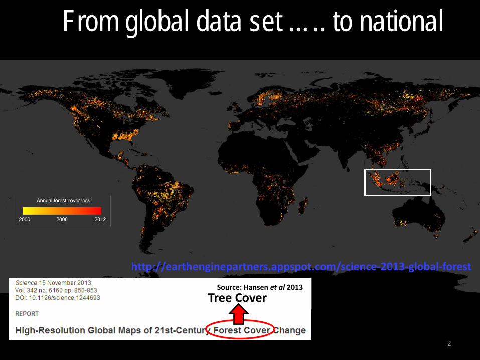
From global data set ….. to national
Source: Hansen et al 2013
2
Tree Cover
http://earthenginepartners.appspot.com/science-2013-global-forest
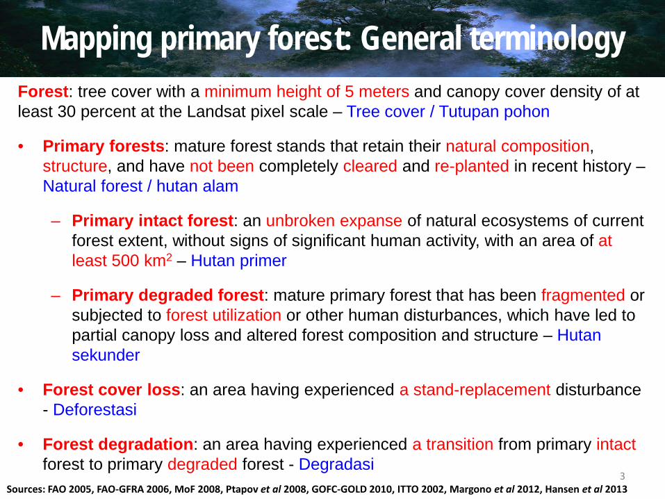
Mapping primary forest: General terminology Forest: tree cover with a minimum height of 5 meters and canopy cover density of at least 30 percent at the Landsat pixel scale – Tree cover / Tutupan pohon
• Primary forests: mature forest stands that retain their natural composition, structure, and have not been completely cleared and re-planted in recent history – Natural forest / hutan alam
– Primary intact forest: an unbroken expanse of natural ecosystems of current forest extent, without signs of significant human activity, with an area of at least 500 km2 – Hutan primer
– Primary degraded forest: mature primary forest that has been fragmented or subjected to forest utilization or other human disturbances, which have led to partial canopy loss and altered forest composition and structure – Hutan sekunder
• Forest cover loss: an area having experienced a stand-replacement disturbance - Deforestasi
• Forest degradation: an area having experienced a transition from primary intact forest to primary degraded forest - Degradasi
Sources: FAO 2005, FAO-GFRA 2006, MoF 2008, Ptapov et al 2008, GOFC-GOLD 2010, ITTO 2002, Margono et al 2012, Hansen et al 2013 3
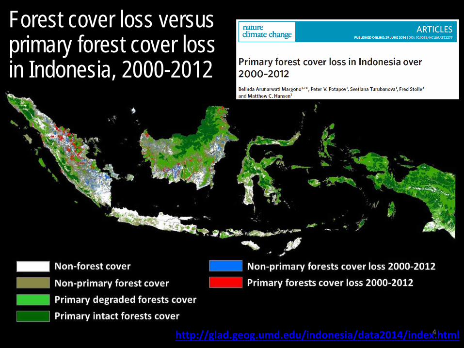
Forest cover loss versus primary forest cover loss in Indonesia, 2000-2012
4 http://glad.geog.umd.edu/indonesia/data2014/index.html
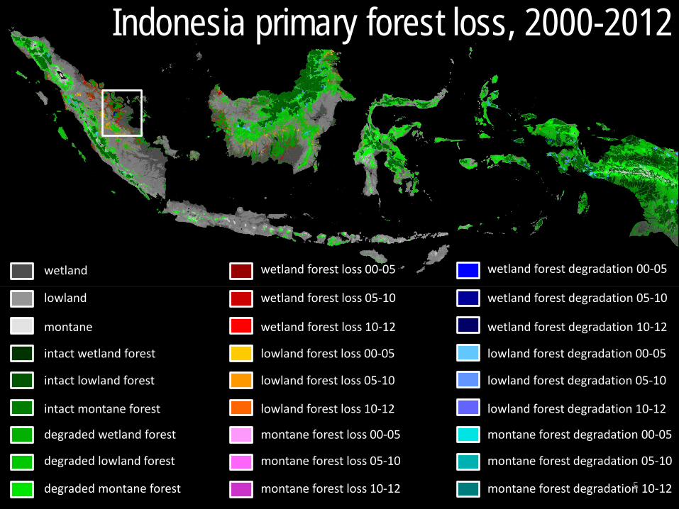
wetland
lowland
montane
intact wetland forest
intact lowland forest
intact montane forest
degraded wetland forest
degraded lowland forest
degraded montane forest
wetland forest loss 00-05
wetland forest loss 05-10
wetland forest loss 10-12
lowland forest loss 00-05
lowland forest loss 05-10
lowland forest loss 10-12
montane forest loss 00-05
montane forest loss 05-10
montane forest loss 10-12
wetland forest degradation 00-05
wetland forest degradation 05-10
wetland forest degradation 10-12
lowland forest degradation 00-05
lowland forest degradation 05-10
lowland forest degradation 10-12
montane forest degradation 00-05
montane forest degradation 05-10
montane forest degradation 10-12
Indonesia primary forest loss, 2000-2012
5
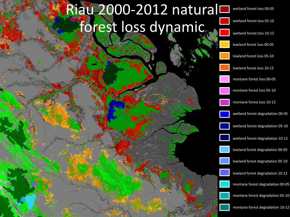
wetland forest loss 00-05
wetland forest loss 05-10
wetland forest loss 10-12
lowland forest loss 00-05
lowland forest loss 05-10
lowland forest loss 10-12
montane forest loss 00-05
montane forest loss 05-10
montane forest loss 10-12
wetland forest degradation 00-05
wetland forest degradation 05-10
wetland forest degradation 10-12
lowland forest degradation 00-05
lowland forest degradation 05-10
lowland forest degradation 10-12
montane forest degradation 00-05
montane forest degradation 05-10
montane forest degradation 10-12
Riau 2000-2012 natural forest loss dynamic
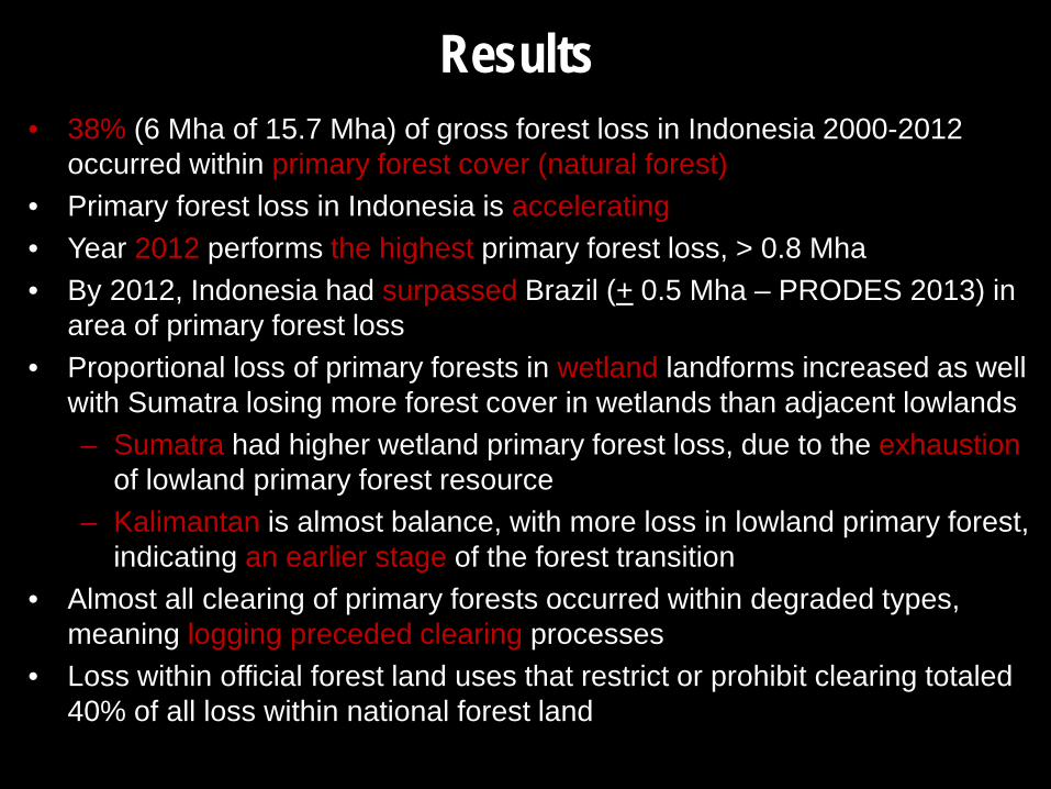
Results • 38% (6 Mha of 15.7 Mha) of gross forest loss in Indonesia 2000-2012
occurred within primary forest cover (natural forest) • Primary forest loss in Indonesia is accelerating • Year 2012 performs the highest primary forest loss, > 0.8 Mha • By 2012, Indonesia had surpassed Brazil (+ 0.5 Mha – PRODES 2013) in
area of primary forest loss • Proportional loss of primary forests in wetland landforms increased as well
with Sumatra losing more forest cover in wetlands than adjacent lowlands – Sumatra had higher wetland primary forest loss, due to the exhaustion
of lowland primary forest resource – Kalimantan is almost balance, with more loss in lowland primary forest,
indicating an earlier stage of the forest transition • Almost all clearing of primary forests occurred within degraded types,
meaning logging preceded clearing processes • Loss within official forest land uses that restrict or prohibit clearing totaled
40% of all loss within national forest land
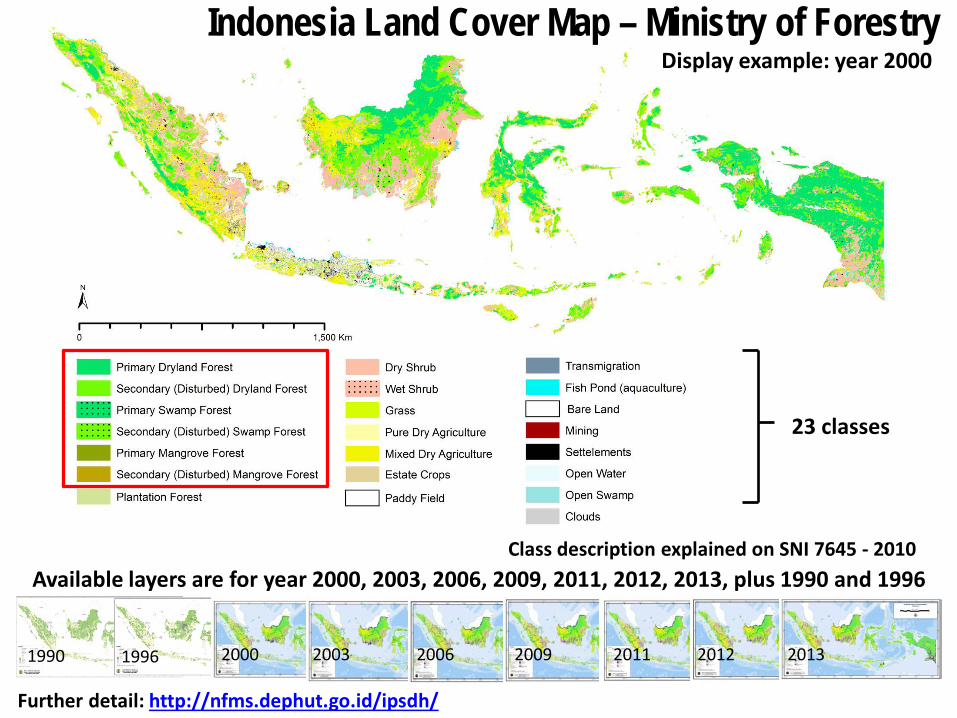
23 classes
Indonesia Land Cover Map – Ministry of Forestry
Class description explained on SNI 7645 - 2010
1990 1996
Available layers are for year 2000, 2003, 2006, 2009, 2011, 2012, 2013, plus 1990 and 1996
2000 2003 2006 2009 2011 2012 2013
Display example: year 2000
Further detail: http://nfms.dephut.go.id/ipsdh/
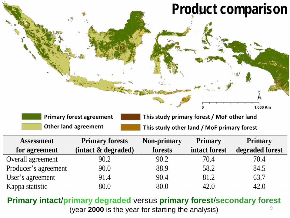
Product comparison
Assessment for agreement
Primary forests (intact & degraded)
Non-primary forests
Primary intact forest
Primary degraded forest
Overall agreement 90.2 90.2 70.4 70.4 Producer’s agreement 90.0 88.9 58.2 84.5 User’s agreement 91.4 90.4 81.2 63.7 Kappa statistic 80.0 80.0 42.0 42.0 Primary intact/primary degraded versus primary forest/secondary forest
(year 2000 is the year for starting the analysis) 9