Indiana Department of Natural Resources Division of Water6 INDIANA QUICK GUIDE Indiana communities...
74
FLOODPLAIN MANAGEMENT IN INDIANA 2018 Indiana Department of Natural Resources Division of Water 402 W. Washington St., Room W264 n Indianapolis, IN 46204 317-232-4160 n in.gov/dnr/water FLOODPLAIN MANAGEMENT IN INDIANA
Transcript of Indiana Department of Natural Resources Division of Water6 INDIANA QUICK GUIDE Indiana communities...
F LOODPLA IN MANAGEMENT IN IND IANA
2018
Indiana Department of Natural Resources Division of Water402 W. Washington St., Room W264 n Indianapolis, IN 46204 317-232-4160 n in.gov/dnr/water
F LOODPLA IN MANAGEMENT IN IND IANA

INDIANA QUICK GUIDE
Table of Contents
1 ........... About This Guide
2 ........... Why Do We Regulate the Floodplain?
3 ........... Indiana Disaster and Floodplain Facts
4 ........... What is the National Flood Insurance Program?
5 ........... Community Responsibilities
6 ........... NFIP Recommended Planning Considerations
7 ........... Flood Insurance: Property Owner’s Financial Protection
8 ........... The NFIP’s Community Rating System (CRS)
9 ........... Looking for FEMA Flood Map Information?
10 ......... FIRMette: FEMA Flood Maps Online
11 ......... Understanding the Riverine Floodplain
12 ......... Indiana Division of Water Regulatory Permit Program
13 ......... Understanding the Regulatory Floodway
14 ......... The Regulatory Floodway
15 ......... Indiana Flood Protection Grade (FPG)
16 ......... Flood Insurance Rate Map (Riverine)
17 ......... Using the Riverine Flood Profile to Determine Riverine BFEs
18 ......... Approximate Flood Zones
19 ......... Flood Insurance Rate Map (Coastal)
20 ......... FIRM Revisions: LOMAs and LOMR-Fs
21 ......... FIRM Revisions: CLOMRs and LOMRs
22 ......... Levee Certification for FIRMs
23 ......... Are Building Sites Higher than the BFE?
24 ......... Activities in SFHAs that Require Local Permits and Approvals
25 ......... Avoid SFHAs When Possible
26 ......... Fill Can Adversely Affect Floodplain Functions
27 ......... Floods Don't Always Stop at the BFE
28 ......... Freeboard: Build Higher, Reduce Damage, Save on ............. Insurance
29 ......... Variances From Elevation Requirements
30 ......... Fundamentals of Flood Resistant Construction
31 ......... Some Key Floodplain Development Permit Review Steps
32 ......... Carefully Complete the Permit Application
33 ......... Communities Must Retain Flood Records Permanently
34 ......... What is the Elevation Certificate and How is it Used?
35 ......... Completing the Elevation Certificate
36 ......... Paperwork is Important for Owners
37 ......... How to Elevate Buildings in Flood Zone A/AE
INDIANA QUICK GUIDE
38 ......... Placement and Compaction of Fill in Zone A/AE
39 ......... Basements in Flood Zones Are Unsafe
40 ......... Enclosures Below the Lowest Floor (Zone A/AE)
41 ......... Crawlspace Details (Zone A/AE)
42 ......... Utility Service and Equipment Inside Enclosures
43 ......... Utility Service, Equipment, and Tanks
44 ......... Pools in Flood Hazard Areas
45 ......... Manufactured Homes Require Special Attention
46 ......... Accessory Structures
47 ......... Recreational Vehicles
48 ......... General Requirements in Coastal High Hazard Areas (Zone V)
49 ......... How to Elevate Buildings in Flood Zone V
50 ......... The Zone V Design Certificate
51 ......... Enclosures Below Zone V
52 ......... Substantial Improvement/Substantial Damage Desk ............. Reference
53 ......... Improvements and Repairs of Buildings in Flood Zones
54 ......... What is Meant by Pre-FIRM and Post-FIRM?
55 ......... Substantial Improvement: Renovation Only
56 ......... Substantial Improvement: Lateral Addition Only
57 ......... Substantial Improvement: Addition Plus Other Work
58 ......... Repair of Damaged Buildings
59 ......... Estimating Substantial Damage
60 ......... Elevating an Existing Building
61 ......... Paying for Post-Flood Compliance
62 ......... Non-Substantial Improvements
63 ......... Some Flood Protection for Older Homes is Easy and ............. Low Cost
64 ......... Small Berms or Floodwalls May Protect Older Buildings
65 ......... Some Flood Mitigation Projects are More Costly
66 ......... Be Prepared for Flood Emergencies
67 ......... StormAware: Turn Around Don't Drown®
68 ......... Useful Resources and Common Acronyms
69 ......... Want to Learn More?
Table of Contents (continued)
INDIANA QUICK GUIDE 1
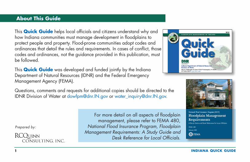
This Quick Guide helps local officials and citizens understand why and how Indiana communities must manage development in floodplains to protect people and property. Flood-prone communities adopt codes and ordinances that detail the rules and requirements. In cases of conflict, those codes and ordinances, not the guidance provided in this publication, must be followed.
This Quick Guide was developed and funded jointly by the Indiana Department of Natural Resources (IDNR) and the Federal Emergency Management Agency (FEMA).
Questions, comments and requests for additional copies should be directed to the IDNR Division of Water at [email protected] or [email protected].
About This GuideAbout This Guide
Prepared by:
For more detail on all aspects of floodplain management, please refer to FEMA 480,
National Flood Insurance Program, Floodplain Management Requirements: A Study Guide and
Desk Reference for Local Officials.
INDIANA QUICK GUIDE 2
Why Do We Regulate the Floodplain?Why Do We Regulate the Floodplain?
To protect people and property. Implementing floodplain management regulations reduces vulnerability to future flood risk. If we know low lying land will flood from time to time, we should make reasonable decisions to help protect our families, homes, and businesses.
To make sure NFIP flood insurance is available. Communities must join the NFIP and administer floodplain management requirements before residents and businesses can purchase NFIP flood insurance and be eligible for some types of Federal assistance, including flood mitigation grants.
To save tax dollars. Every time communities experience flood disasters local budgets are impacted. If we build smart, we’ll have fewer problems the next time the water rises. Remember, Federal disaster assistance is not available for all floods. Even when the President declares a disaster, communities still must pay a portion of repair and clean-up costs, temporary housing assistance, and evacuation expenses.
To avoid liability and lawsuits. If we know an area is mapped as a flood hazard area, and if we know people could be in danger and buildings could be damaged, doesn’t it make sense to take reasonable protective steps as our communities develop and redevelop?
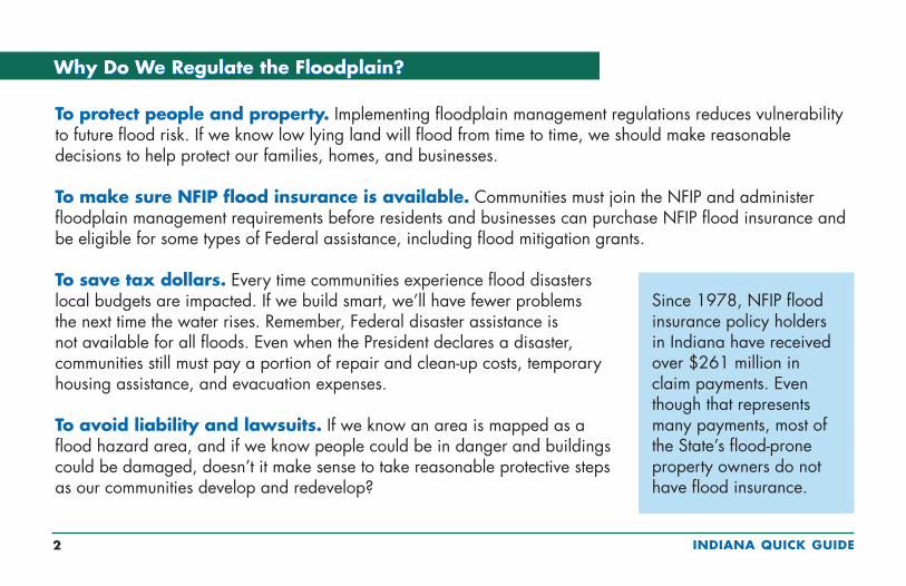
Since 1978, NFIP flood insurance policy holders in Indiana have received over $261 million in claim payments. Even though that represents many payments, most of the State’s flood-prone property owners do not have flood insurance.

INDIANA QUICK GUIDE 3
Indiana Disaster and Floodplain Facts
n More than half of Indiana’s declared disasters involved flooding. Winter storms and tornadoes account for the rest.
n Most counties, cities and towns in Indiana have identified floodprone areas shown on Flood Insurance Rate Maps.
n Thousands of buildings and other structures are located in identified floodprone areas, called Special Flood Hazard Areas (SFHAs).
n Flood maps have not been prepared for many waterways.
n Two counties and 72 municipalities are floodprone but elect to not participate in the National Flood Insurance Program and do not enforce floodplain management regulations (as of April 2018).
Many flood events are not declared major disasters. Many floods are local, affecting only small areas such as several homes, a limited number of communities, or a few watersheds.
Number of Declarations by County (1988 to mid-2018)
4 – 8
9 – 10
11 – 12
13 – 14
15 – 17+
FederalDisaster Declarations
unty
INDIANA QUICK GUIDE 4
The National Flood Insurance Program (NFIP) was created by Congress in 1968 to protect lives and property and to reduce the financial burden of providing disaster assistance. The NFIP is administered by the Federal Emergency Management Agency (FEMA). Nationwide, over 22,300 communities participate in the NFIP. In Indiana, more than 440 counties, cities and towns participate.
The NFIP is based on a mutual agreement between the Federal Government and communities. Communities that participate agree to regulate development in mapped flood hazard areas according to certain criteria and standards. The partnership involves:
n Flood hazard maps. In partnership with water management districts, communities and the State, FEMA produces flood maps in accordance with FEMA standards. The maps are used by communities, insurance agents, real estate professionals, and others.
n Flood insurance. Property owners and renters in participating communities are eligible to purchase NFIP flood insurance for buildings and contents.
n Regulations. Communities must adopt and enforce minimum floodplain management regulations so that development, including buildings, is undertaken in ways that reduce exposure to flooding.
What is the National Flood Insurance Program?
To learn more about the NFIP, including your potential flood risk and the approximate cost of a flood insurance policy, go to FEMA’s FloodSmart website www.floodsmart.gov.

INDIANA QUICK GUIDE 5
To participate in the National Flood Insurance Program, Indiana communities agree to:
n Recognize flood hazards in community planning (see page 6) n Adopt and enforce flood maps and a flood damage prevention ordinancen Require permits for all types of development in the floodplain (see page 24)n Assure that building sites are reasonably safe from floodingn Require new and substantially improved homes and manufactured homes to be
elevated at or above the FPG (BFE + 2 ft.)n Require non-residential buildings to be elevated at or above the FPG (BFE + 2 ft.),
or dry floodproofedn Determine if damaged buildings are substantially damagedn Conduct field inspections; cite and remedy violationsn Require and maintain surveyed elevation information to document compliance (see pages 33, 34, and 36)n Carefully consider requests for variancesn Resolve non-compliance and violations of floodplain management requirementsn Advise and work with FEMA and the IDNR Division of Water when updates to flood maps are neededn Maintain records for review and respond to periodic requests for reports to FEMA
Community Responsibilities

INDIANA QUICK GUIDE 6
Indiana communities should consider incorporating planning considerations into comprehensive plans, land development codes, floodplain management regulations, and multi-hazard mitigation plans to reflect the long-term goal of increasing resiliency to future flooding. NFIP regulations (44 CFR Section 60.22(c)) outline 19 factors for consideration, including:
n Divert development to areas outside the SFHA to reduce flood damage
n Full public disclosure to potential buyers of properties in the SFHA
n Acknowledge that SFHA development may increase flood risk of existing development
n Improve local drainage to control increased runoff that increases the probability of flooding on other properties
n Require additional elevation above the minimum (e.g., above the State minimum FPG + 1ft.)
n Require elevation methods such as pilings or columns rather than fill to maintain the storage capacity of the floodplain and to minimize environmental impacts
n Require evacuation plans for manufactured home parks and subdivisions
NFIP Recommended Planning Considerations
INDIANA QUICK GUIDE 7
Who needs flood insurance? Flood insurance is required for all buildings in mapped flood zones shown on FEMA’s maps if they are financed by Federally-backed loans or mortgages. All homeowners, business owners, and renters in communities that participate in the NFIP may purchase NFIP flood insurance on any building and its contents, even if outside of the mapped flood zone. Homes in mapped flood zones are five times more likely to be damaged by flooding than by major fires.
Not in a mapped flood zone? Unfortunately, it’s often after a flood that many people discover that their home or business property insurance does NOT cover flood damage. Approximately 25% of all flood damage occurs in low risk zones, commonly described as being “outside the mapped flood zone.”
Protected by a levee or dam? Even areas protected by levees or other flood control structures have some risk of flooding if the structures are overtopped or fail. Even when levees provide “100-year” flood protection, there is still a chance that a higher flood will occur.
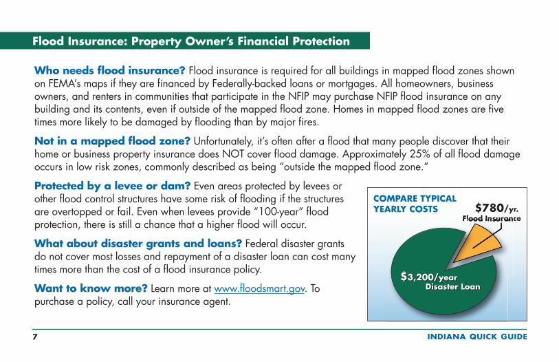
What about disaster grants and loans? Federal disaster grants do not cover most losses and repayment of a disaster loan can cost many times more than the cost of a flood insurance policy.
Want to know more? Learn more at www.floodsmart.gov. To purchase a policy, call your insurance agent.
Flood Insurance: Property Owner’s Financial Protection

INDIANA QUICK GUIDE 8
The NFIP’s Community Rating System (CRS)
Community officials can request assistance from CRS specialists to help with the application process and prerequisites. Check the online CRS Resource Center (see page 68).
The NFIP recognizes communities that achieve better flood resiliency by providing policy holders with reduced flood insurance premiums. Communities must apply to participate in CRS and commit to implement and certify activities that contribute to reduced flood risk. Examples of actions communities can take to reduce the cost of flood insurance premiums include:
n Preserve open space in the floodplainn Enforce higher standards for safer development through zoning,
stormwater, subdivision, and flood damage protection ordinancesn Develop hazard mitigation plans and watershed and storm management plansn Undertake engineering studies and prepare flood mapsn Obtain grants to buy out or elevate houses or to floodproof businessesn Maintain drainage systemsn Monitor flood conditions and issue warningsn Inform people about flood hazards, flood insurance, and how to reduce flood damage
Property owners in 32 Indiana communities that participate in the CRS receive premium discounts ranging from 5% to 15% (as of April 2018).
INDIANA QUICK GUIDE 9
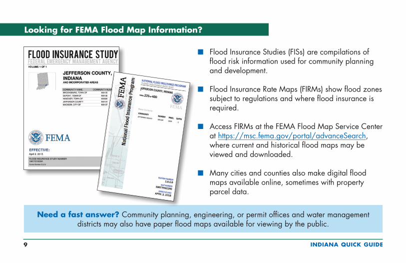
n Flood Insurance Studies (FISs) are compilations of flood risk information used for community planning and development.
n Flood Insurance Rate Maps (FIRMs) show flood zones subject to regulations and where flood insurance is required.
n Access FIRMs at the FEMA Flood Map Service Center at https://msc.fema.gov/portal/advanceSearch, where current and historical flood maps may be viewed and downloaded.
n Many cities and counties also make digital flood maps available online, sometimes with property parcel data.
Looking for FEMA Flood Map Information?
Need a fast answer? Community planning, engineering, or permit offices and water management districts may also have paper flood maps available for viewing by the public.
INDIANA QUICK GUIDE 10
Go to https://msc.fema.gov and check out the “MSC Frequently Asked Questions.” For step-by-step instructions on how to read flood maps and view the How to Read a Flood
Insurance Rate Map Tutorial.
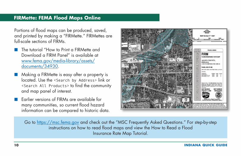
Portions of flood maps can be produced, saved, and printed by making a “FIRMette.” FIRMettes are full-scale sections of FIRMs.
n The tutorial “How to Print a FIRMette and Download a FIRM Panel” is available at www.fema.gov/media-library/assets/documents/34930.
n Making a FIRMette is easy after a property is located. Use the <Search by Address> link or <Search All Products> to find the community and map panel of interest.
n Earlier versions of FIRMs are available for many communities, so current flood hazard information can be compared to historic data.
FIRMette: FEMA Flood Maps Online
INDIANA QUICK GUIDE 11
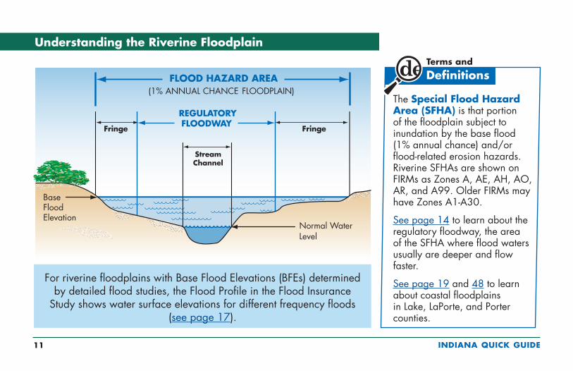
Understanding the Riverine Floodplain
For riverine floodplains with Base Flood Elevations (BFEs) determined by detailed flood studies, the Flood Profile in the Flood Insurance
Study shows water surface elevations for different frequency floods (see page 17).
The Special Flood Hazard Area (SFHA) is that portion of the floodplain subject to inundation by the base flood (1% annual chance) and/or flood-related erosion hazards. Riverine SFHAs are shown on FIRMs as Zones A, AE, AH, AO, AR, and A99. Older FIRMs may have Zones A1-A30.
See page 14 to learn about the regulatory floodway, the area of the SFHA where flood waters usually are deeper and flow faster.
See page 19 and 48 to learn about coastal floodplains in Lake, LaPorte, and Porter counties.
INDIANA QUICK GUIDE 12
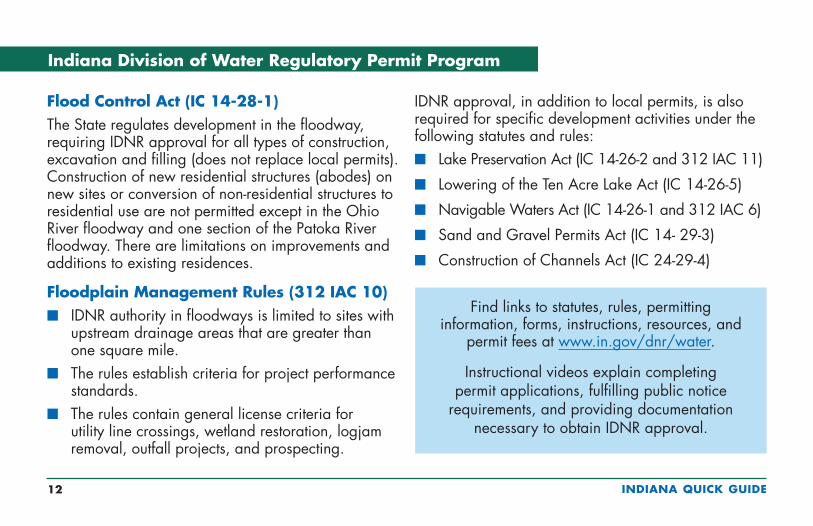
Flood Control Act (IC 14-28-1)The State regulates development in the floodway, requiring IDNR approval for all types of construction, excavation and filling (does not replace local permits). Construction of new residential structures (abodes) on new sites or conversion of non-residential structures to residential use are not permitted except in the Ohio River floodway and one section of the Patoka River floodway. There are limitations on improvements and additions to existing residences.
Floodplain Management Rules (312 IAC 10)n IDNR authority in floodways is limited to sites with
upstream drainage areas that are greater than one square mile.
n The rules establish criteria for project performance standards.
n The rules contain general license criteria for utility line crossings, wetland restoration, logjam removal, outfall projects, and prospecting.
IDNR approval, in addition to local permits, is also required for specific development activities under the following statutes and rules:n Lake Preservation Act (IC 14-26-2 and 312 IAC 11)
n Lowering of the Ten Acre Lake Act (IC 14-26-5)
n Navigable Waters Act (IC 14-26-1 and 312 IAC 6)
n Sand and Gravel Permits Act (IC 14- 29-3)
n Construction of Channels Act (IC 24-29-4)
Indiana Division of Water Regulatory Permit Program
Find links to statutes, rules, permitting information, forms, instructions, resources, and
permit fees at www.in.gov/dnr/water.
Instructional videos explain completing permit applications, fulfilling public notice
requirements, and providing documentation necessary to obtain IDNR approval.
INDIANA QUICK GUIDE 13
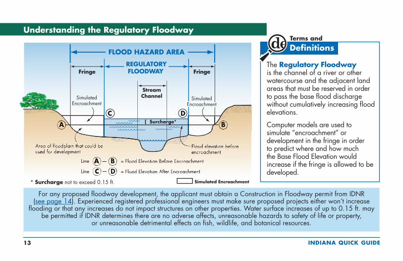
Understanding the Regulatory Floodway
For any proposed floodway development, the applicant must obtain a Construction in Floodway permit from IDNR (see page 14). Experienced registered professional engineers must make sure proposed projects either won’t increase
flooding or that any increases do not impact structures on other properties. Water surface increases of up to 0.15 ft. may be permitted if IDNR determines there are no adverse affects, unreasonable hazards to safety of life or property,
or unreasonable detrimental effects on fish, wildlife, and botanical resources.
The Regulatory Floodway is the channel of a river or other watercourse and the adjacent land areas that must be reserved in order to pass the base flood discharge without cumulatively increasing flood elevations.
Computer models are used to simulate “encroachment” or development in the fringe in order to predict where and how much the Base Flood Elevation would increase if the fringe is allowed to be developed.
* Surcharge not to exceed 0.15 ft.

INDIANA QUICK GUIDE 14
Reduce flood risk – don’t build in the
Floodway!
n Floodways convey the largest volume of water and may have high velocities.
n Some communities restrict development in regulatory floodways.
n Engineers may be required to prepare floodway encroachment analyses to evaluate the hydraulic impact of proposed development.
n Development is not allowed unless IDNR issues a Construction in a Floodway permit.
n Fencing in floodways can be problematic due to snagging and encroachment. Proposed fencing materials and designs must be reviewed for potential impacts.
The Regulatory Floodway
INDIANA QUICK GUIDE 15
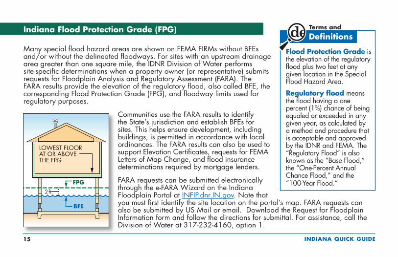
Indiana Flood Protection Grade (FPG)
Many special flood hazard areas are shown on FEMA FIRMs without BFEs and/or without the delineated floodways. For sites with an upstream drainage area greater than one square mile, the IDNR Division of Water performs site-specific determinations when a property owner (or representative) submits requests for Floodplain Analysis and Regulatory Assessment (FARA). The FARA results provide the elevation of the regulatory flood, also called BFE, the corresponding Flood Protection Grade (FPG), and floodway limits used for regulatory purposes.
Communities use the FARA results to identify the State’s jurisdiction and establish BFEs for sites. This helps ensure development, including buildings, is permitted in accordance with local ordinances. The FARA results can also be used to support Elevation Certificates, requests for FEMA Letters of Map Change, and flood insurance determinations required by mortgage lenders.
FARA requests can be submitted electronically through the e-FARA Wizard on the Indiana Floodplain Portal at INFIP.dnr.IN.gov. Note that you must first identify the site location on the portal’s map. FARA requests can also be submitted by US Mail or email. Download the Request for Floodplain Information form and follow the directions for submittal. For assistance, call the Division of Water at 317-232-4160, option 1.
Flood Protection Grade is the elevation of the regulatory flood plus two feet at any given location in the Special Flood Hazard Area.
Regulatory flood means the flood having a one percent (1%) chance of being equaled or exceeded in any given year, as calculated by a method and procedure that is acceptable and approved by the IDNR and FEMA. The “Regulatory Flood” is also known as the “Base Flood,” the “One-Percent Annual Chance Flood,” and the “100-Year Flood.”
INDIANA QUICK GUIDE 16
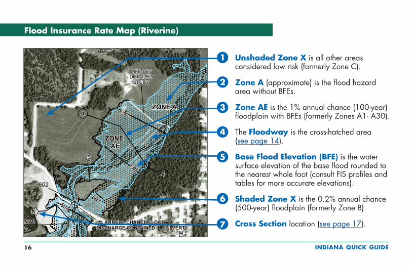
Flood Insurance Rate Map (Riverine)
Unshaded Zone X is all other areas considered low risk (formerly Zone C).
Zone A (approximate) is the flood hazard area without BFEs.
Zone AE is the 1% annual chance (100-year) floodplain with BFEs (formerly Zones A1- A30).
The Floodway is the cross-hatched area (see page 14).
Base Flood Elevation (BFE) is the water surface elevation of the base flood rounded to the nearest whole foot (consult FIS profiles and tables for more accurate elevations).
Shaded Zone X is the 0.2% annual chance (500-year) floodplain (formerly Zone B).
Cross Section location (see page 17).
1
2
3
4
5
6
7
INDIANA QUICK GUIDE 17
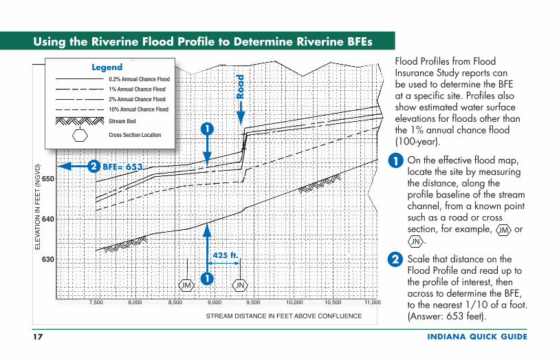
650
640
630
BFE= 653BFE= 653
Using the Riverine Flood Profile to Determine Riverine BFEs
Flood Profiles from Flood Insurance Study reports can be used to determine the BFE at a specific site. Profiles also show estimated water surface elevations for floods other than the 1% annual chance flood (100-year).
On the effective flood map, locate the site by measuring the distance, along the profile baseline of the stream channel, from a known point such as a road or cross section, for example, or
.
Scale that distance on the Flood Profile and read up to the profile of interest, then across to determine the BFE, to the nearest 1/10 of a foot. (Answer: 653 feet).
1
2
0.2% Annual Chance Flood
1% Annual Chance Flood
2% Annual Chance Flood
10% Annual Chance Flood
Stream Bed
Cross Section Location
INDIANA QUICK GUIDE 18
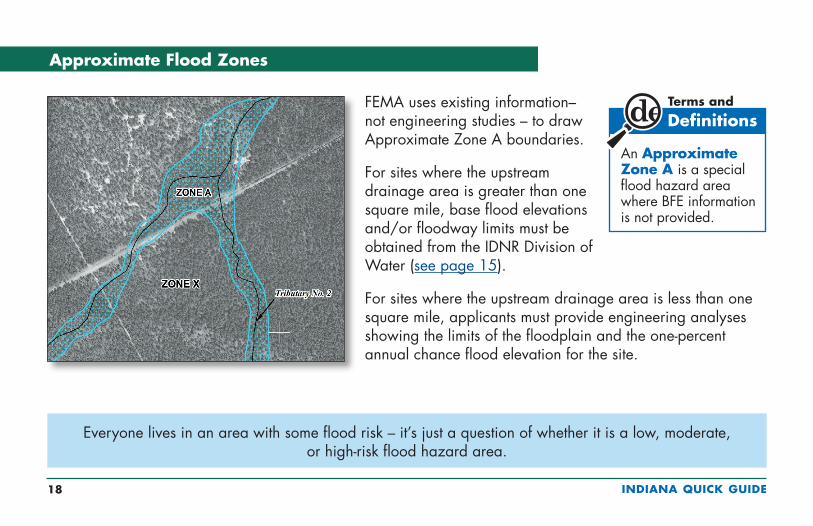
Approximate Flood Zones
FEMA uses existing information– not engineering studies – to draw Approximate Zone A boundaries.
For sites where the upstream drainage area is greater than one square mile, base flood elevations and/or floodway limits must be obtained from the IDNR Division of Water (see page 15).
For sites where the upstream drainage area is less than one square mile, applicants must provide engineering analyses showing the limits of the floodplain and the one-percent annual chance flood elevation for the site.
An Approximate Zone A is a special flood hazard area where BFE information is not provided.
Everyone lives in an area with some flood risk – it’s just a question of whether it is a low, moderate, or high-risk flood hazard area.

INDIANA QUICK GUIDE 19
Flood Insurance Rate Map (Coastal)
Zone AE is subject to flooding by the base or 1% annual chance (100-year) flood, and waves less than 3 feet high, (formerly Zones A1-A30).
Zone VE is where wave heights are expected to be 3 feet or more.
Base Flood Elevation (BFE) is the water surface elevation (in feet above the vertical datum shown on the map).
Shaded Zone X is the 0.2% annual chance (500-year) floodplain (formerly Zone B).
Unshaded Zone X is the area of minimal flood risk outside the 0.2% annual chance (500-year) floodplain (formerly Zone C).
4
3
2
1
5

INDIANA QUICK GUIDE 20
Letter of Map Amendment (LOMA) is an official amendment to an effective FIRM that may be issued when a property owner provides additional technical information from a professional surveyor, such as ground elevation
relative to the BFE. Lenders may waive the flood insurance requirement if the LOMA removes a building site from the SFHA because natural ground at the site is at or above the BFE.
The most accurate information available is used to make flood maps, including topographic base maps and detailed engineering methods or methods of approximation. FEMA issues map revisions if technical data are submitted to support the changes.
Letter of Map Revision Based on Fill (LOMR-F) is an official revision to an effective FIRM that is issued to document FEMA’s determination that a structure or parcel of land has been elevated by fill
above the BFE, and therefore is no longer in the SFHA. Lenders may waive the insurance requirement if the LOMR-F removes a building site from the SFHA.
FIRM Revisions: LOMAs and LOMR-Fs
Check www.fema.gov/letter-map-amendment-letter-map-revision-based-fill-process for guidance on map revisions. Access to FEMA’s web-based application for professional surveyors to submit eLOMAs is
hazards.fema.gov/femaportal/resources/whatiseloma.htm.
INDIANA QUICK GUIDE 21
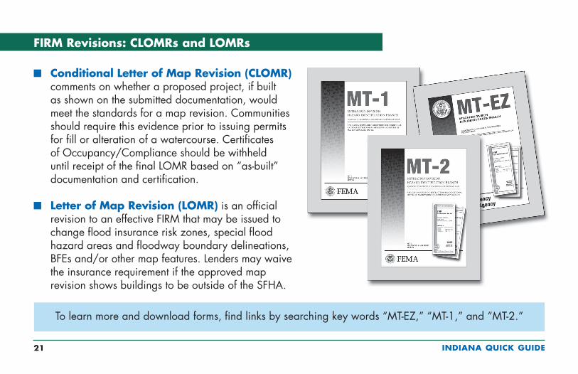
n Conditional Letter of Map Revision (CLOMR) comments on whether a proposed project, if built as shown on the submitted documentation, would meet the standards for a map revision. Communities should require this evidence prior to issuing permits for fill or alteration of a watercourse. Certificates of Occupancy/Compliance should be withheld until receipt of the final LOMR based on “as-built” documentation and certification.
n Letter of Map Revision (LOMR) is an official revision to an effective FIRM that may be issued to change flood insurance risk zones, special flood hazard areas and floodway boundary delineations, BFEs and/or other map features. Lenders may waive the insurance requirement if the approved map revision shows buildings to be outside of the SFHA.
FIRM Revisions: CLOMRs and LOMRs
To learn more and download forms, find links by searching key words “MT-EZ,” “MT-1,” and “MT-2.”

INDIANA QUICK GUIDE 22
Many levees are designed to protect land against flooding from the Base Flood. In order for FEMA to show those areas as outside of the Special Flood Hazard Area, communities and levee owners must certify that levees meet certain design criteria. Certification will present significant challenges during the map revision process.
Communities that have levees should determine as soon as possible whether certification will be required. Pursuant to FEMA’s Procedural Memoranda 34 and 43, and as outlined in Federal regulations at 44 CFR Section 65.10, the documentation requirements address:
n Freeboard
n Closures
n Embankment protection for erosion
n Embankment and foundation stability
n Settlement
n Interior drainage and seepage
n Operation and maintenance plans
n Other site specific criteria
Levee Certification for FIRMs
*
* Freeboard is the distance between the BFE and the top of the levee; for FEMA accreditation freeboard is usually 3 feet
INDIANA QUICK GUIDE 23
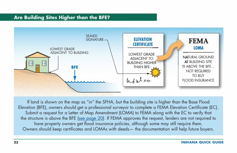
If land is shown on the map as “in” the SFHA, but the building site is higher than the Base Flood Elevation (BFE), owners should get a professional surveyor to complete a FEMA Elevation Certificate (EC).
Submit a request for a Letter of Map Amendment (LOMA) to FEMA along with the EC to verify that the structure is above the BFE (see page 20). If FEMA approves the request, lenders are not required to
have property owners get flood insurance policies, although some may still require them. Owners should keep certificates and LOMAs with deeds— the documentation will help future buyers.
Are Building Sites Higher than the BFE?

INDIANA QUICK GUIDE 24
Floodplain development or building permits must be obtained before these activities and ANY land-disturbing activities occur in flood zones.
n Construction of new buildingsn Additions to buildingsn Improvements to buildingsn Renovation of building interiorsn Repair of damaged buildingsn Placement of manufactured (mobile) homesn Subdivision of landn Construction or placement of temporary buildings and
accessory structuresn Construction of agricultural buildingsn Construction of roads, bridges, and culvertsn Placement of fill, grading, excavation, mining, and dredgingn Alteration of stream channels
Activities in SFHAs that Require Local Permits and Approvals
INDIANA QUICK GUIDE 25
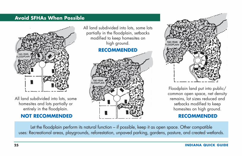
Avoid SFHAs When Possible
Let the floodplain perform its natural function – if possible, keep it as open space. Other compatible uses: Recreational areas, playgrounds, reforestation, unpaved parking, gardens, pasture, and created wetlands.
All land subdivided into lots, some lots partially in the floodplain, setbacks
modified to keep homesites on high ground.
RECOMMENDED
Floodplain land put into public/common open space, net density remains, lot sizes reduced and
setbacks modified to keep homesites on high ground.
RECOMMENDED
All land subdivided into lots, some homesites and lots partially or
entirely in the floodplain.
NOT RECOMMENDED
INDIANA QUICK GUIDE 26
Fill Can Adversely Affect Floodplain Functions
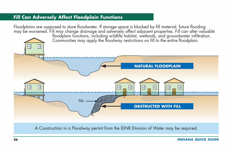
Floodplains are supposed to store floodwater. If storage space is blocked by fill material, future flooding may be worsened. Fill may change drainage and adversely affect adjacent properties. Fill can alter valuable
floodplain functions, including wildlife habitat, wetlands, and groundwater infiltration. Communities may apply the floodway restrictions on fill to the entire floodplain.
A Construction in a Floodway permit from the IDNR Division of Water may be required.

INDIANA QUICK GUIDE 27
CAUTION! Major storms and flash floods can cause flooding that rises higher than the Base Flood Elevation (BFE). Be safer – protect your home or business by avoiding
flood zones or building higher. See page 28 to see how this will save you money on flood insurance.
Floods Don't Always Stop at the BFE
Many people don’t understand just how risky building in flood zones can be. There is a greater than 26% chance that a non-elevated home in the SFHA will be flooded during a 30-year mortgage period. The chance that a major fire will occur during the same period is less than 5%!

INDIANA QUICK GUIDE 28
Freeboard is additional height – a factor of safety – above the BFE. Buildings that are higher than the BFE experience less damage. Owners of buildings elevated above the BFE also save on NFIP flood insurance. NOTE! Flood insurance
rates and various fees change from time to time. Rather than specific costs for insurance, these figures give a feel for how much difference just a foot or two can make.
Remember! Builders must submit floor elevations as part of foundation inspections. An error of just 6 or 12 inches could more than double the cost of NFIP flood insurance.
A community may be able to grant a variance, but the owner will probably be required to buy insurance. Imagine trying to sell a house if the bank requires insurance that costs more than $10,000 a year!
Freeboard: Build Higher, Reduce Damage, Save on Insurance
* Unofficial estimates using 2018 rates; use only for comparison purposes** Savings over at-BFE premium
*
Maximum dwelling coverage ($250,000) and contents ($100,000) for 1-4 family home (no basment, no enclosure, no crawlspace). Fees not incuded.
+4
+3
+2
+1
BFE
–1
–2
–3
–4
$0 $1,000 $2,000 $3,000 $4,000 $5,000 $6,000 $7,000 $8,000 $9,000 $10,000
FPG (BFE +2 ft.)is minimum requiredelevation
** 74%
** 73%
** 67%
** 49%

INDIANA QUICK GUIDE 29
Property owners and communities must carefully consider the impacts of variances to allow buildings below the FPG. Not only will buildings be more likely to sustain flood damage,
but NFIP flood insurance will be very costly. Communities with a pattern of granting variances may be subject to NFIP sanctions, costing all insurance policyholders even more.
Very specific conditions related to the property (not the owner’s actions or preferences) must be satisfied to justify a variance:
n Good and sufficient cause
n Unique site conditions
n Non-economic hardship
n If in the floodway, no increase in flood level
A variance that allows construction or substantial improvement below the FPG does not waive the lender’s flood insurance requirement. Below the BFE, flood insurance will be more expensive – perhaps more than $10,000 per year (see page 28)!
Variances From Elevation Requirements

INDIANA QUICK GUIDE 30
In short ... flood resistant buildings!
Two objectives of the NFIP are to reduce flood damage and guide development to less hazard prone areas. When buildings are built in special flood hazard areas, increased resistance to flooding is achieved by the following fundamentals:
n Foundations capable of resisting flood loads (including dry floodproofed nonresidential buildings)
n Lowest floors elevated high enough to prevent floodwater from entering during the design event
n Equipment and utilities elevated or designed to remain intact and be restored easily
n Enclosures below elevated floors limited to parking, limited storage, and building access and designed to minimize damage
n Flood damage-resistant materials used below elevated lowest floors
Fundamentals of Flood Resistant Construction
Many Indiana communities require critical facilities to be located outside of SFHAs. When alternative sites are not available, critical facilities should be elevated higher than the Flood Protection Grade (FPG), see page 15.
INDIANA QUICK GUIDE 31
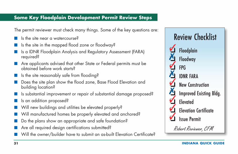
Some Key Floodplain Development Permit Review Steps
The permit reviewer must check many things. Some of the key questions are:
n Is the site near a watercourse?n Is the site in the mapped flood zone or floodway?n Is a IDNR Floodplain Analysis and Regulatory Assessment (FARA)
required?n Are applicants advised that other State or Federal permits must be
obtained before work starts?n Is the site reasonably safe from flooding?n Does the site plan show the flood zone, Base Flood Elevation and
building location?n Is substantial improvement or repair of substantial damage proposed?n Is an addition proposed?n Will new buildings and utilities be elevated properly?n Will manufactured homes be properly elevated and anchored?n Do the plans show an appropriate and safe foundation?n Are all required design certifications submitted?n Will the owner/builder have to submit an as-built Elevation Certificate?
Review Checklist���������
���������
FloodplainFloodwayFPGIDNR FARANew ConstructionImproved Existing Bldg.ElevatedElevation CertificateIssue Permit
Robert Reviewer, CFM

INDIANA QUICK GUIDE 32
Good information will lead to better construction and less exposure to future flood damage. Contact the local floodplain administrator or building, planning or
engineering department for application forms and guidance.
You must get all permits before you work in a flood zone.
Carefully Complete the Permit Application
Part of Floodplain Development Permit Application (only key parts shown)
Application No.: _________________ Date Filed: _________________Applicant: ______________________________________________________________
Is proposed development: � New construction. � Substantial modifications. � Other (describe): _____________________________Property located in Zone _______________ on FIRM dated: ___________________Location is: � Floodway/Fringe not determined. � Fringe. � Floodway.Applicant must notify IDNR, with site plans, if in Floodway or undetermined floodplain areas. Attach copy of IDNR permit or floodplain analysis or regulatory assessment (FARA; e-FARA).Base Flood Elevation (BFE) at site: ___________ NAVD Flood Protection Grade (FPG) at site: _________ NAVD
Approved by: __________________________ Title: ___________________________
2018-12David and Sally Jones
Fill and gradingAE 12/9/2014
759761
Robert Reviwer Building Official
3/24/2018
�
�
INDIANA QUICK GUIDE 33
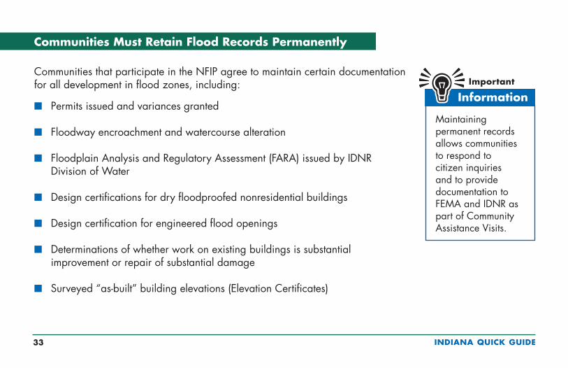
Communities that participate in the NFIP agree to maintain certain documentation for all development in flood zones, including:
n Permits issued and variances granted
n Floodway encroachment and watercourse alteration
n Floodplain Analysis and Regulatory Assessment (FARA) issued by IDNR Division of Water
n Design certifications for dry floodproofed nonresidential buildings
n Design certification for engineered flood openings
n Determinations of whether work on existing buildings is substantial improvement or repair of substantial damage
n Surveyed “as-built” building elevations (Elevation Certificates)
Maintaining permanent records allows communities to respond to citizen inquiries and to provide documentation to FEMA and IDNR as part of Community Assistance Visits.
Communities Must Retain Flood Records Permanently

INDIANA QUICK GUIDE 34
By itself, the EC cannot be used to waive the requirement to obtain flood insurance. See page 20 to learn about FEMA’s
Letter of Map Amendment process.
n The Elevation Certificate (EC) is a FEMA form. Go to www.fema.gov and search for “Elevation Certificate.”
n The EC must be completed and sealed by a professional surveyor licensed in Indiana.
n Community officials may complete the EC for sites in Zone AO (see Section G of the EC).
n It can be used to show that lowest grades adjacent to planned or existing building sites are above the Base Flood Elevation (see page 23).
n It is used to verify building and equipment elevations.
n Insurance agents use the EC to write and rate flood insurance policies.
n See page 69 for online Elevation Certificate training information.
What is the Elevation Certificate and How is it Used?
INDIANA QUICK GUIDE 35
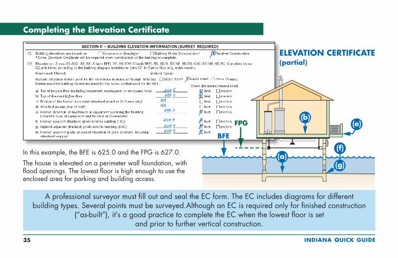
Completing the Elevation Certificate
In this example, the BFE is 625.0 and the FPG is 627.0.
The house is elevated on a perimeter wall foundation, with flood openings. The lowest floor is high enough to use the enclosed area for parking and building access.
ELEVATION CERTIFICATE(partial)
623 8633 0
N/AN/A
633 0
623 4623 4623 4
X
X
X
X
XXX
A professional surveyor must fill out and seal the EC form. The EC includes diagrams for different building types. Several points must be surveyed.Although an EC is required only for finished construction
(“as-built”), it’s a good practice to complete the EC when the lowest floor is set and prior to further vertical construction.
X
INDIANA QUICK GUIDE 36
ELEVATIONCERTIFICATE
LOWEST FLOORAT OR ABOVE
REQUIREDELEVATION
COMPACTED FILL OROTHER ELEVATION METHOD
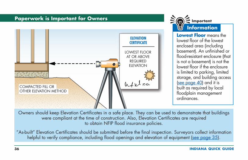
Paperwork is Important for Owners
Lowest Floor means the lowest floor of the lowest enclosed area (including basement). An unfinished or flood-resistant enclosure (that is not a basement) is not the lowest floor if the enclosure is limited to parking, limited storage, and building access (see page 40) and it is built as required by local floodplain management ordinances.
Owners should keep Elevation Certificates in a safe place. They can be used to demonstrate that buildings were compliant at the time of construction. Also, Elevation Certificates are required
to obtain NFIP flood insurance policies.
“As-built” Elevation Certificates should be submitted before the final inspection. Surveyors collect information helpful to verify compliance, including flood openings and elevation of equipment (see page 35).

INDIANA QUICK GUIDE 37
CAUTION! Enclosures (including crawlspaces) have some specific requirements (see page 40). Note: When the walking surface of the lowest floor is at the FPG, under-floor utilities are not allowed.
Fill used to elevate buildings must be placed properly (see page 26).
How to Elevate Buildings in Flood Zone A/AE
(Fill may adversely affect drainage and flood levels, see page 26).
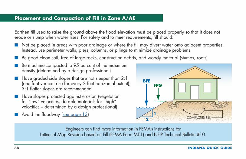
INDIANA QUICK GUIDE 38
Earthen fill used to raise the ground above the flood elevation must be placed properly so that it does not erode or slump when water rises. For safety and to meet requirements, fill should:
n Not be placed in areas with poor drainage or where the fill may divert water onto adjacent properties. Instead, use perimeter walls, piers, columns, or pilings to minimize drainage problems.
n Be good clean soil, free of large rocks, construction debris, and woody material (stumps, roots)
n Be machine-compacted to 95 percent of the maximum density (determined by a design professional)
n Have graded side slopes that are not steeper than 2:1 (one foot vertical rise for every 2 feet horizontal extent); 3:1 flatter slopes are recommended
n Have slopes protected against erosion (vegetation for “low” velocities, durable materials for “high” velocities – determined by a design professional)
n Avoid the floodway (see page 13)
Engineers can find more information in FEMA’s instructions for Letters of Map Revision based on Fill (FEMA Form MT-1) and NFIP Technical Bulletin #10.
Placement and Compaction of Fill in Zone A/AE
INDIANA QUICK GUIDE 39
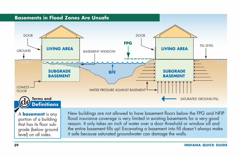
New buildings are not allowed to have basement floors below the FPG and NFIP flood insurance coverage is very limited in existing basements for a very good reason. It only takes an inch of water over a door threshold or window sill and the entire basement fills up! Excavating a basement into fill doesn’t always make it safe because saturated groundwater can damage the walls.
A basement is any portion of a building that has its floor sub-grade (below ground level) on all sides.
Basements in Flood Zones Are Unsafe
INDIANA QUICK GUIDE 40
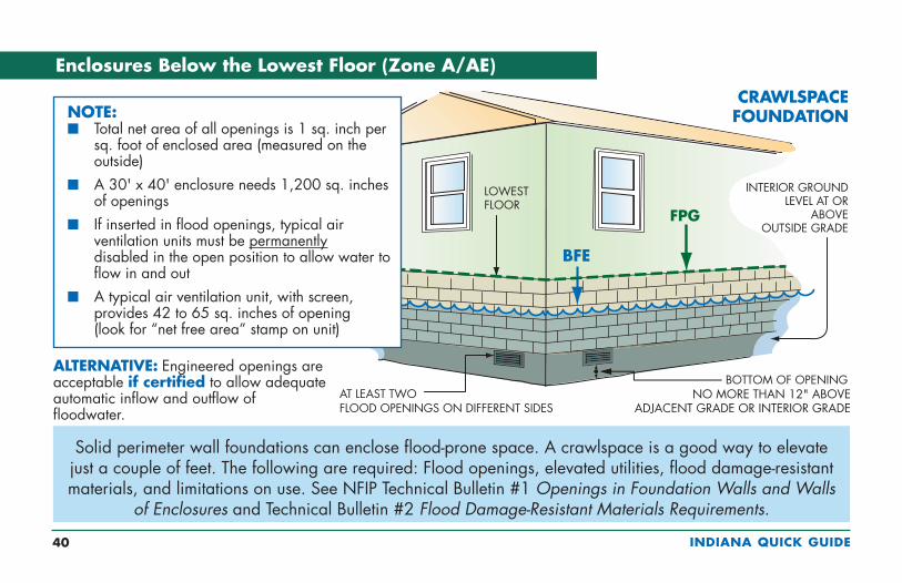
Enclosures Below the Lowest Floor (Zone A/AE)
NOTE:n Total net area of all openings is 1 sq. inch per
sq. foot of enclosed area (measured on the outside)
n A 30' x 40' enclosure needs 1,200 sq. inches of openings
n If inserted in flood openings, typical air ventilation units must be permanently disabled in the open position to allow water to flow in and out
n A typical air ventilation unit, with screen, provides 42 to 65 sq. inches of opening (look for “net free area” stamp on unit)
Solid perimeter wall foundations can enclose flood-prone space. A crawlspace is a good way to elevate just a couple of feet. The following are required: Flood openings, elevated utilities, flood damage-resistant materials, and limitations on use. See NFIP Technical Bulletin #1 Openings in Foundation Walls and Walls
of Enclosures and Technical Bulletin #2 Flood Damage-Resistant Materials Requirements.
ALTERNATIVE: Engineered openings are acceptable if certified to allow adequate automatic inflow and outflow of floodwater.

INDIANA QUICK GUIDE 41
Crawlspace Details (Zone A/AE)
n The Lowest Floor must be at or above the Flood Protection Grade (BFE + 2 ft).
n All materials below the lowest floor must be flood resistant.
n Flood openings must provide 1 sq. in. of net open area for every sq. ft. of area enclosed by the perimeter walls – or certified engineered openings may be used.
n A 30' x 40' building needs 1,200 sq. in. of net opening (non-engineered).
n The bottom of flood openings must be no more than 12 inches above the higher of the interior and exterior grades.
n Standard air ventilation units must be permanently disabled in the “open” position to allow water to flow in and out.
n Interior grade must be equal to or higher than exterior grade on at least one side.
INDIANA QUICK GUIDE 42
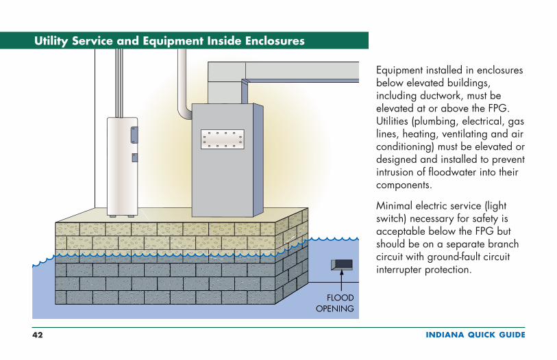
Equipment installed in enclosures below elevated buildings, including ductwork, must be elevated at or above the FPG. Utilities (plumbing, electrical, gas lines, heating, ventilating and air conditioning) must be elevated or designed and installed to prevent intrusion of floodwater into their components.
Minimal electric service (light switch) necessary for safety is acceptable below the FPG but should be on a separate branch circuit with ground-fault circuit interrupter protection.
Utility Service and Equipment Inside Enclosures
INDIANA QUICK GUIDE 43
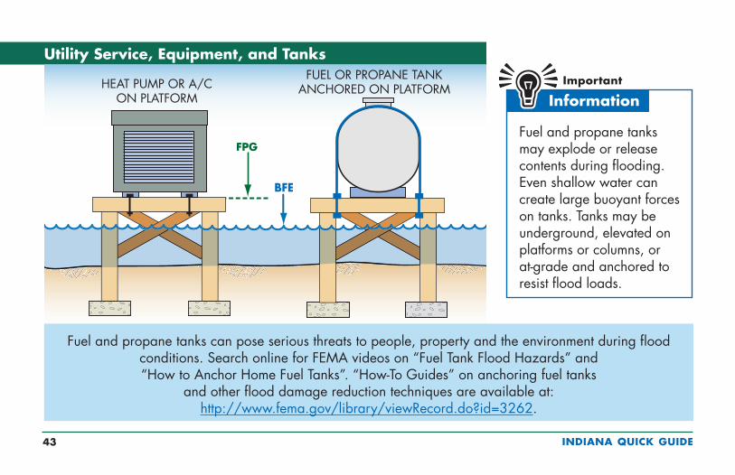
Utility Service, Equipment, and Tanks
Fuel and propane tanks can pose serious threats to people, property and the environment during flood conditions. Search online for FEMA videos on “Fuel Tank Flood Hazards” and “How to Anchor Home Fuel Tanks”. “How-To Guides” on anchoring fuel tanks
and other flood damage reduction techniques are available at: http://www.fema.gov/library/viewRecord.do?id=3262.
Fuel and propane tanks may explode or release contents during flooding. Even shallow water can create large buoyant forces on tanks. Tanks may be underground, elevated on platforms or columns, or at-grade and anchored to resist flood loads.
HEAT PUMP OR A/CON PLATFORM
FUEL OR PROPANE TANKANCHORED ON PLATFORM
INDIANA QUICK GUIDE 44
Pools in Flood Hazard Areas
Pools in flood hazard areas should be designed and constructed to be stable during flooding. Empty pools may be dislodged if the surrounding soil becomes saturated. Where a pool is located and whether it is in-ground, above-ground, or a combination (perhaps with associated grading and fill) determine requirements:
n Floodway (see page 13) and riverine flood hazard area with BFEs but no floodway, prior written authorization from INDR required for pools (above-ground, in-ground, and pools with fill)
n Fringe (see page 13), no additional requirements
In addition:
n Pool houses used to store hazardous chemicals and/or those with floor area larger than 400 sq. ft. must be elevated at or above the FPG (see page 37).
n Pool controls and equipment must meet the requirements for utility service (see page 43).
INDIANA QUICK GUIDE 45
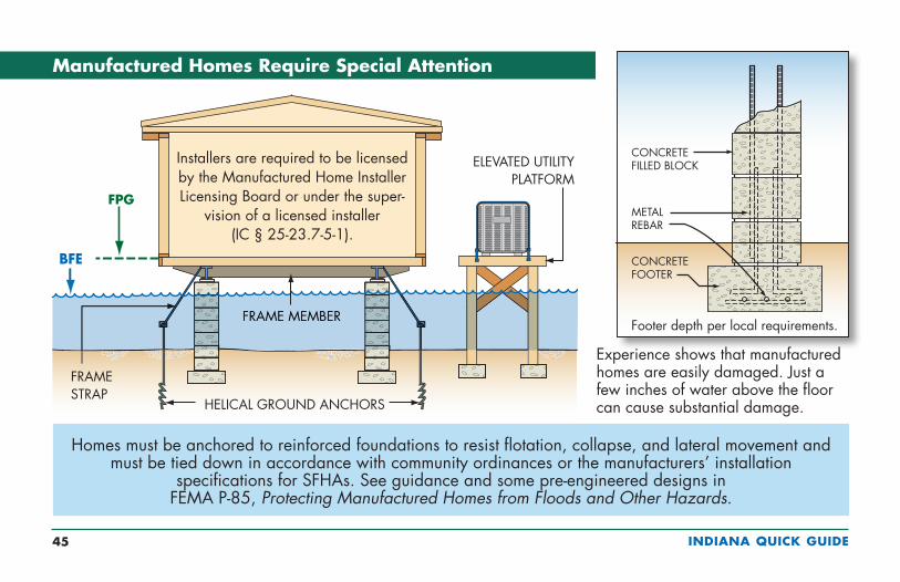
Experience shows that manufactured homes are easily damaged. Just a few inches of water above the floor can cause substantial damage.
Manufactured Homes Require Special Attention
Homes must be anchored to reinforced foundations to resist flotation, collapse, and lateral movement and must be tied down in accordance with community ordinances or the manufacturers’ installation
specifications for SFHAs. See guidance and some pre-engineered designs in FEMA P-85, Protecting Manufactured Homes from Floods and Other Hazards.
Installers are required to be licensed by the Manufactured Home Installer Licensing Board or under the super-
vision of a licensed installer (IC § 25-23.7-5-1).
Footer depth per local requirements.

INDIANA QUICK GUIDE 46
If not elevated, accessory structures in flood zones must:
n Be less than 400 sq. ft. in floor area
n Not be habitable
n Be used only for parking or storage (not pollutants or hazardous materials)
n Be anchored to resist floating
n Have flood openings
n Be built of flood damage-resistant materials
n Have elevated utilities
n Not be modified for different use in the future
Examples of accessory structures are detached garages, carports, storage sheds, pole barns, and hay sheds.
Accessory Structures
Even small buildings are “development” and permits or variances with noted conditions are required. They must be elevated or anchored and built to resist flood damage.
Caution! Remember, everything inside will get wet when flooding occurs.
INDIANA QUICK GUIDE 47
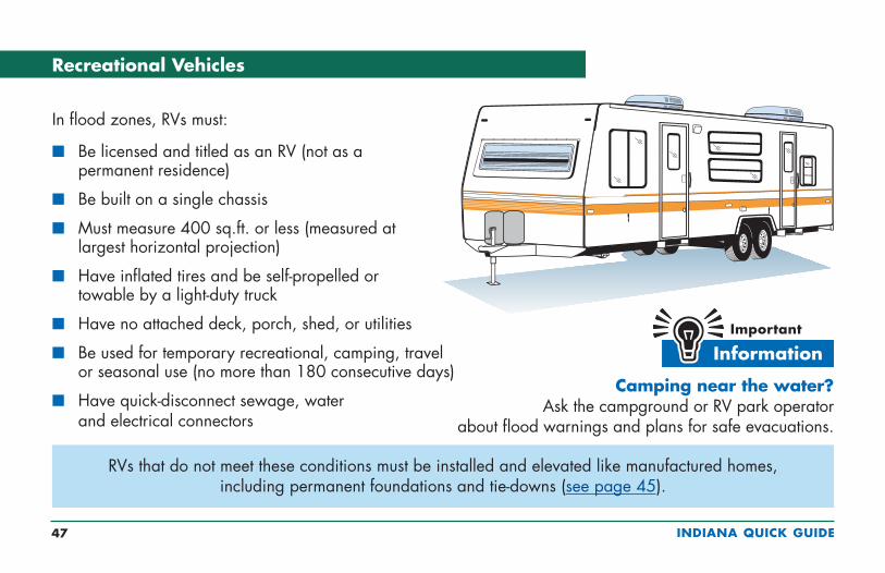
Recreational Vehicles
RVs that do not meet these conditions must be installed and elevated like manufactured homes, including permanent foundations and tie-downs (see page 45).
Camping near the water? Ask the campground or RV park operator
about flood warnings and plans for safe evacuations.
In flood zones, RVs must:
n Be licensed and titled as an RV (not as a permanent residence)
n Be built on a single chassis
n Must measure 400 sq.ft. or less (measured at largest horizontal projection)
n Have inflated tires and be self-propelled or towable by a light-duty truck
n Have no attached deck, porch, shed, or utilities
n Be used for temporary recreational, camping, travel or seasonal use (no more than 180 consecutive days)
n Have quick-disconnect sewage, water and electrical connectors
INDIANA QUICK GUIDE 48
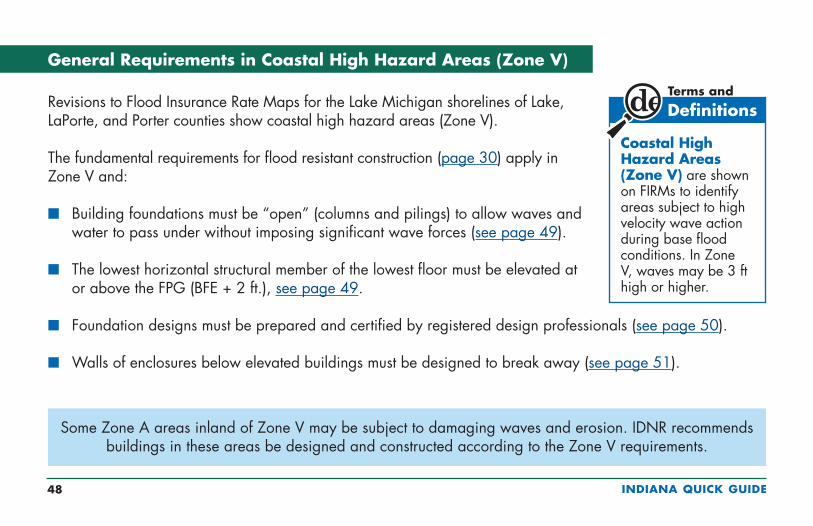
General Requirements in Coastal High Hazard Areas (Zone V)
Some Zone A areas inland of Zone V may be subject to damaging waves and erosion. IDNR recommends buildings in these areas be designed and constructed according to the Zone V requirements.
Revisions to Flood Insurance Rate Maps for the Lake Michigan shorelines of Lake, LaPorte, and Porter counties show coastal high hazard areas (Zone V).
The fundamental requirements for flood resistant construction (page 30) apply in Zone V and:
n Building foundations must be “open” (columns and pilings) to allow waves and water to pass under without imposing significant wave forces (see page 49).
n The lowest horizontal structural member of the lowest floor must be elevated at or above the FPG (BFE + 2 ft.), see page 49.
n Foundation designs must be prepared and certified by registered design professionals (see page 50).
n Walls of enclosures below elevated buildings must be designed to break away (see page 51).
Coastal High Hazard Areas (Zone V) are shown on FIRMs to identify areas subject to high velocity wave action during base flood conditions. In Zone V, waves may be 3 ft high or higher.
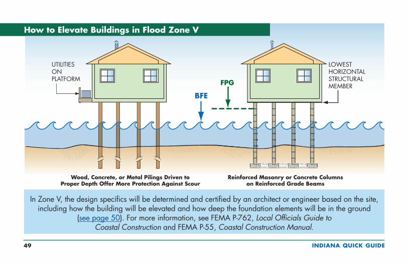
INDIANA QUICK GUIDE 49
In Zone V, the design specifics will be determined and certified by an architect or engineer based on the site, including how the building will be elevated and how deep the foundation elements will be in the ground
(see page 50). For more information, see FEMA P-762, Local Officials Guide to Coastal Construction and FEMA P-55, Coastal Construction Manual.
How to Elevate Buildings in Flood Zone V
INDIANA QUICK GUIDE 50
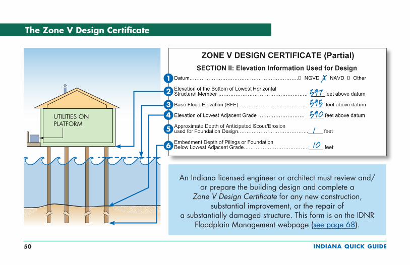
The Zone V Design Certificate
UTILITIES ON PLATFORM
1
2
3
5
4
6
597595590110
X
An Indiana licensed engineer or architect must review and/or prepare the building design and complete a
Zone V Design Certificate for any new construction, substantial improvement, or the repair of
a substantially damaged structure. This form is on the IDNR Floodplain Management webpage (see page 68).
INDIANA QUICK GUIDE 51
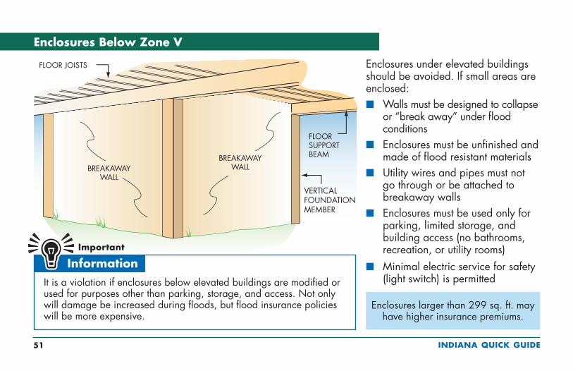
Enclosures Below Zone V
Enclosures under elevated buildings should be avoided. If small areas are enclosed:n Walls must be designed to collapse
or “break away” under flood conditions
n Enclosures must be unfinished and made of flood resistant materials
n Utility wires and pipes must not go through or be attached to breakaway walls
n Enclosures must be used only for parking, limited storage, and building access (no bathrooms, recreation, or utility rooms)
n Minimal electric service for safety (light switch) is permittedIt is a violation if enclosures below elevated buildings are modified or
used for purposes other than parking, storage, and access. Not only will damage be increased during floods, but flood insurance policies will be more expensive.
Enclosures larger than 299 sq. ft. may have higher insurance premiums.
INDIANA QUICK GUIDE 52
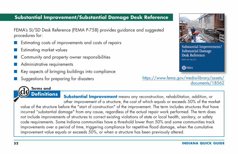
Substantial Improvement/Substantial Damage Desk Reference
FEMA’s SI/SD Desk Reference (FEMA P-758) provides guidance and suggested procedures for:
n Estimating costs of improvements and costs of repairs
n Estimating market values
n Community and property owner responsibilities
n Administrative requirements
n Key aspects of bringing buildings into compliance
n Suggestions for preparing for disasters
Substantial Improvement means any reconstruction, rehabilitation, addition, or other improvement of a structure, the cost of which equals or exceeds 50% of the market
value of the structure before the "start of construction" of the improvement. The term includes structures that have incurred “substantial damage" from any cause, regardless of the actual repair work performed. The term does not include improvements of structures to correct existing violations of state or local health, sanitary, or safety code requirements. Some Indiana communities have a threshold lower than 50% and some communities track improvements over a period of time, triggering compliance for repetitive flood damage, when the cumulative improvement value equals or exceeds 50%, or when a structure has been previously altered.
https://www.fema.gov/media-library/assets/documents/18562

INDIANA QUICK GUIDE 53
Improvements and Repairs of Buildings in Flood Zones
Permits to improve and repair buildings are required. Local officials must:
n Review costs estimated in construction contracts or other cost estimates (including estimate market value of owner labor and donated labor and materials).
n Estimate the market value using property assessment records or use an independent assessment of market value performed by a licensed appraiser.
n Compare the costs of improvements and costs of repairs to the market value of the building.
n Require buildings to be brought into full compliance if the costs equal or exceed 50% of the market value, called Substantial Improvement (or repair of Substantial Damage).
n Encourage owners to consider other ways to reduce future damage if the comparison is less than 50% (see page 62).
Improvements include:
n Renovation/rehabilitation of the interior of the existing building (see page 55)
n Lateral addition, without renovation or structural alteration of the existing building (see page 56)
n Lateral addition, with renovation or structural alteration of the existing building (see page 57)
n Vertical addition (add new story)
INDIANA QUICK GUIDE 54
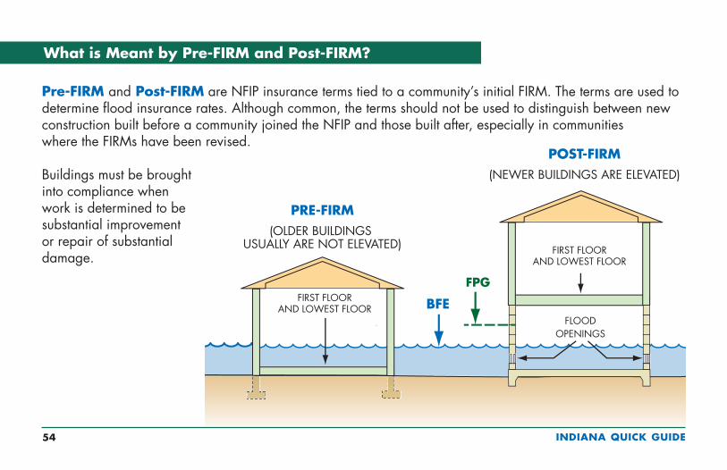
What is Meant by Pre-FIRM and Post-FIRM?
Pre-FIRM and Post-FIRM are NFIP insurance terms tied to a community’s initial FIRM. The terms are used to determine flood insurance rates. Although common, the terms should not be used to distinguish between new construction built before a community joined the NFIP and those built after, especially in communities where the FIRMs have been revised.
Buildings must be brought into compliance when work is determined to be substantial improvement or repair of substantial damage.
INDIANA QUICK GUIDE 55
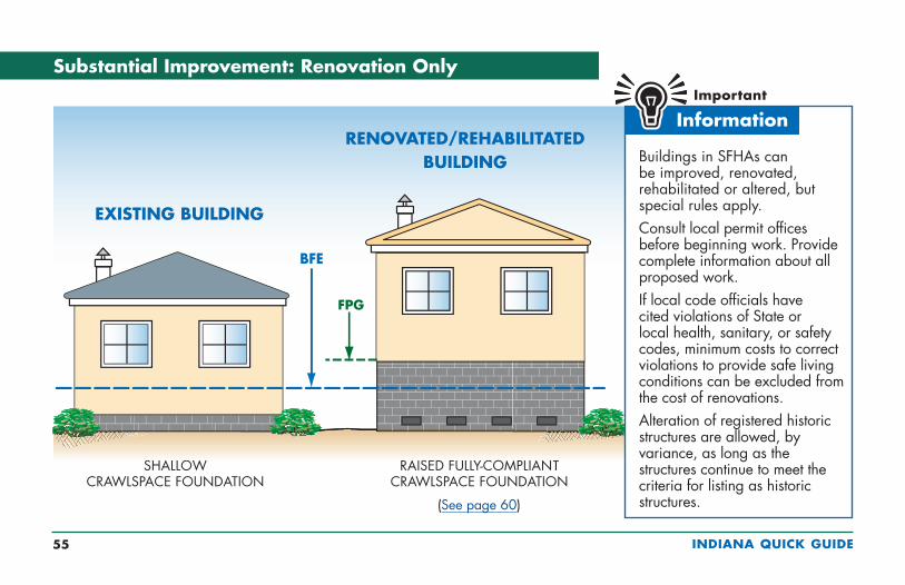
Substantial Improvement: Renovation Only
Buildings in SFHAs can be improved, renovated, rehabilitated or altered, but special rules apply.Consult local permit offices before beginning work. Provide complete information about all proposed work.If local code officials have cited violations of State or local health, sanitary, or safety codes, minimum costs to correct violations to provide safe living conditions can be excluded from the cost of renovations.Alteration of registered historic structures are allowed, by variance, as long as the structures continue to meet the criteria for listing as historic structures.
EXISTING BUILDING
RENOVATED/REHABILITATEDBUILDING
(See page 60)

INDIANA QUICK GUIDE 56
Substantial Improvement: Lateral Addition Only
Permits are required to build additions to buildings in flood zones. Only the addition must be elevated and comply provided:
n There are no other modifications to the existing building, and
n There are no structural modifications to the existing common wall other than adding a standard 36" doorway
See page 57 for projects to add lateral additions that also modify the interior of the existing building or make structural modifications to the existing common wall.
INDIANA QUICK GUIDE 57
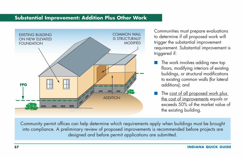
Substantial Improvement: Addition Plus Other Work
Communities must prepare evaluations to determine if all proposed work will trigger the substantial improvement requirement. Substantial improvement is triggered if:
n The work involves adding new top floors, modifying interiors of existing buildings, or structural modifications to existing common walls (for lateral additions); and
n The cost of all proposed work plus the cost of improvements equals or exceeds 50% of the market value of the existing building.
Community permit offices can help determine which requirements apply when buildings must be brought into compliance. A preliminary review of proposed improvements is recommended before projects are
designed and before permit applications are submitted.
INDIANA QUICK GUIDE 58
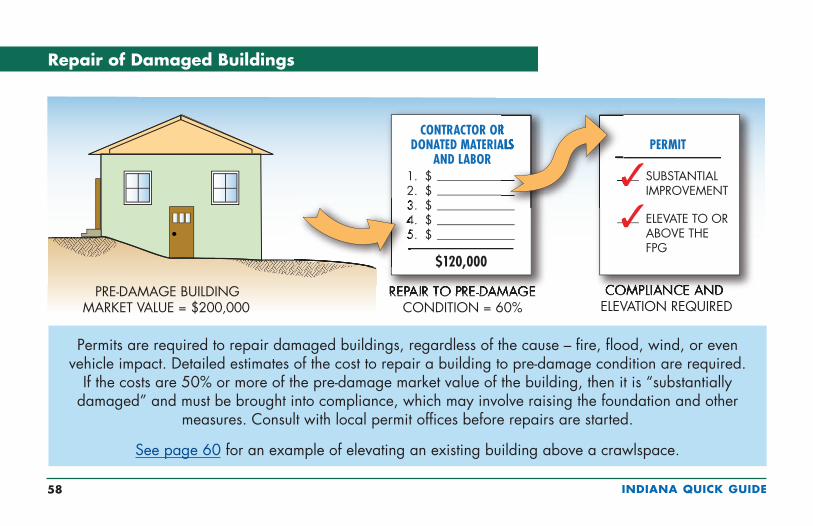
Repair of Damaged Buildings
Permits are required to repair damaged buildings, regardless of the cause – fire, flood, wind, or even vehicle impact. Detailed estimates of the cost to repair a building to pre-damage condition are required.
If the costs are 50% or more of the pre-damage market value of the building, then it is “substantially damaged” and must be brought into compliance, which may involve raising the foundation and other
measures. Consult with local permit offices before repairs are started.
See page 60 for an example of elevating an existing building above a crawlspace.

INDIANA QUICK GUIDE 59
Estimating Substantial Damage
In addition to valuable advice for planning for and administering floodplain management requirements after floods, IDNR’s “Post-Flood Guidance” includes a Depth-Damage Field Estimate worksheet based on the U.S. Army Corps of Engineers depth-damage relationships.
FEMA’s SDE tool was developed to help State and local officials in collecting uniform information needed to make substantial damage determinations for residential and non-residential structures in accordance with local floodplain management requirements. The SDE tool:
n Can be used to assess flood, wind, wildfire, seismic, and other forms of damage
n Helps provide timely substantial damage determinations so that reconstruction can begin following events that damage buildings
n Is used in conjunction with industry-accepted construction cost-estimating guides
Download the SDE software installation package, User Manual and Workbook, forms, worksheets and other materials at https://www.fema.gov/media-library/assets/documents/18692.

INDIANA QUICK GUIDE 60
Elevating an Existing Building
This is one way to elevate an existing building to comply with building code and floodplain regulations (also see FEMA P-312, Homeowner’s Guide to Retrofitting). If an NFIP-insured building is damaged by
flood and the community determines it is substantially damaged, the owner may be eligible for an Increased Cost of Compliance payment (see page 61).

INDIANA QUICK GUIDE 61
Paying for Post-Flood Compliance
Owners whose buildings are substantially damaged are required to “bring the buildings into compliance” with flood zone requirements.
USE THE ICC CLAIM TO:
ELEVATE-IN- PLACE
RELOCATE TO HIGH GROUND
DEMOLISH
FLOODPROOF (NON-RESIDENTIAL ONLY)
Owners may be eligible for up to $30,000 to help pay to bring buildings into compliance with building code and community requirements – if all of the following apply:
n Buildings are located in a mapped flood zonen Buildings are covered by NFIP flood insurance, which includes
Increased Cost of Compliance coveragen Buildings have lowest floors below the BFEn The community made an official determination that buildings were
substantially damaged by floodingn Substantial damage may be one-time 50% or by repetitive flood
damage in communities that enforce repetitive loss provisionsn Owners act quickly with their claims adjusters and community officials
to process all required paperwork
Learn more at www.fema.gov/increased-cost-compliance-coverage.
INDIANA QUICK GUIDE 62
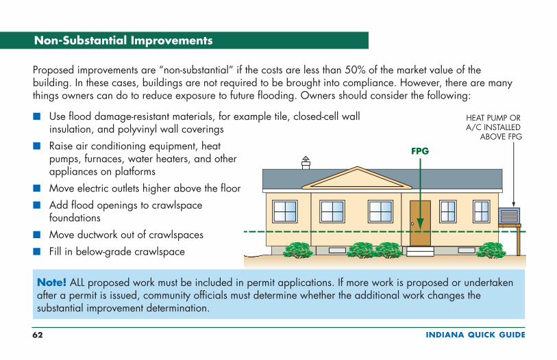
Non-Substantial Improvements
Proposed improvements are “non-substantial” if the costs are less than 50% of the market value of the building. In these cases, buildings are not required to be brought into compliance. However, there are many things owners can do to reduce exposure to future flooding. Owners should consider the following:
n Use flood damage-resistant materials, for example tile, closed-cell wall insulation, and polyvinyl wall coverings
n Raise air conditioning equipment, heat pumps, furnaces, water heaters, and other appliances on platforms
n Move electric outlets higher above the floor
n Add flood openings to crawlspace foundations
n Move ductwork out of crawlspaces
n Fill in below-grade crawlspace
Note! ALL proposed work must be included in permit applications. If more work is proposed or undertaken after a permit is issued, community officials must determine whether the additional work changes the substantial improvement determination.
INDIANA QUICK GUIDE 63
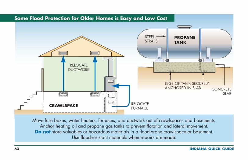
Some Flood Protection for Older Homes is Easy and Low Cost
Move fuse boxes, water heaters, furnaces, and ductwork out of crawlspaces and basements. Anchor heating oil and propane gas tanks to prevent flotation and lateral movement.
Do not store valuables or hazardous materials in a flood-prone crawlspace or basement. Use flood-resistant materials when repairs are made.
INDIANA QUICK GUIDE 64
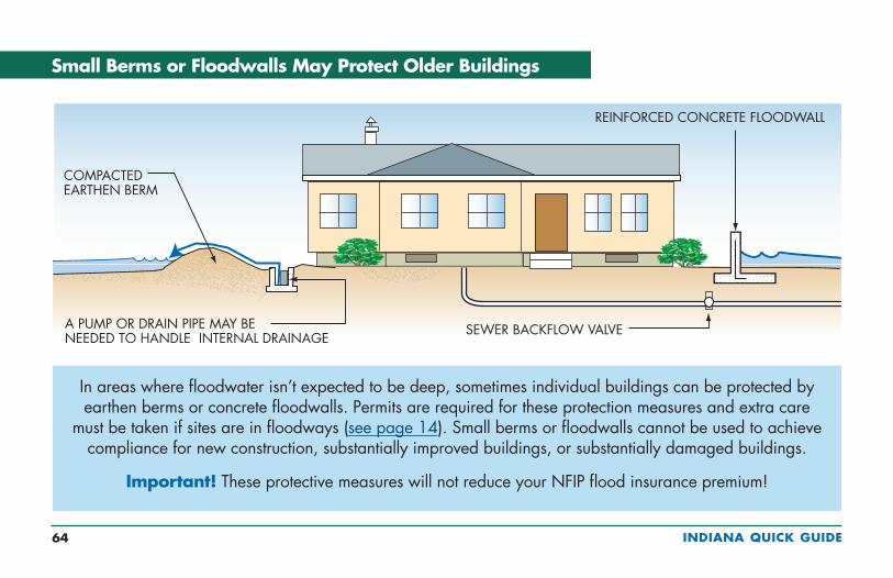
Small Berms or Floodwalls May Protect Older Buildings
In areas where floodwater isn’t expected to be deep, sometimes individual buildings can be protected by earthen berms or concrete floodwalls. Permits are required for these protection measures and extra care
must be taken if sites are in floodways (see page 14). Small berms or floodwalls cannot be used to achieve compliance for new construction, substantially improved buildings, or substantially damaged buildings.
Important! These protective measures will not reduce your NFIP flood insurance premium!
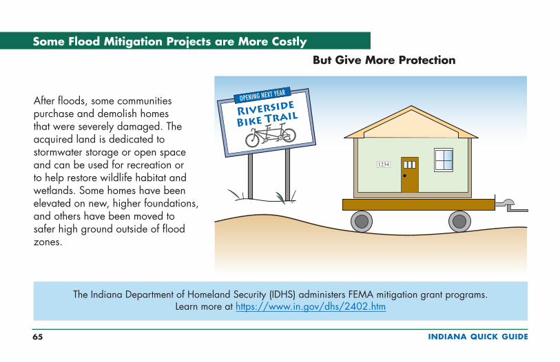
INDIANA QUICK GUIDE 65
But Give More Protection
The Indiana Department of Homeland Security (IDHS) administers FEMA mitigation grant programs. Learn more at https://www.in.gov/dhs/2402.htm
Some Flood Mitigation Projects are More Costly
After floods, some communities purchase and demolish homes that were severely damaged. The acquired land is dedicated to stormwater storage or open space and can be used for recreation or to help restore wildlife habitat and wetlands. Some homes have been elevated on new, higher foundations, and others have been moved to safer high ground outside of flood zones.
1234
INDIANA QUICK GUIDE 66
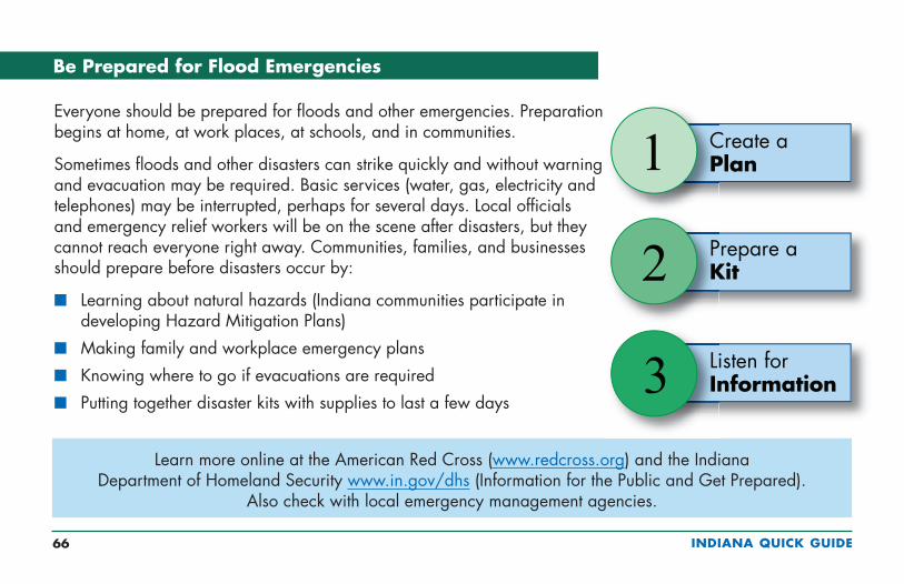
Be Prepared for Flood Emergencies
Everyone should be prepared for floods and other emergencies. Preparation begins at home, at work places, at schools, and in communities.
Sometimes floods and other disasters can strike quickly and without warning and evacuation may be required. Basic services (water, gas, electricity and telephones) may be interrupted, perhaps for several days. Local officials and emergency relief workers will be on the scene after disasters, but they cannot reach everyone right away. Communities, families, and businesses should prepare before disasters occur by:
n Learning about natural hazards (Indiana communities participate in developing Hazard Mitigation Plans)
n Making family and workplace emergency plans
n Knowing where to go if evacuations are required
n Putting together disaster kits with supplies to last a few days
Learn more online at the American Red Cross (www.redcross.org) and the Indiana Department of Homeland Security www.in.gov/dhs (Information for the Public and Get Prepared).
Also check with local emergency management agencies.
Create a Plan1
2
3
Prepare a Kit
Listen for Information

INDIANA QUICK GUIDE 67
StormAware: Turn Around Don't Drown®
Learn about flood risks and follow these safety rules:
n When flooding is expected, stay away from creeks, streams, and rivers.
n NEVER drive through flooded roads – they may be washed out.
n Passenger cars may float in only 12-24 inches of water.
n Be especially cautious at night when it is harder to recognize dangers.
n Just 6 inches of fast-moving water can knock you off your feet.
n http://tadd.weather.gov.

INDIANA QUICK GUIDE 68
Useful Resources and Common Acronyms
n Indiana Department of Natural Resources, Division of Water, Floodplain Management, information for community officials and homeowners and related links: www.in.gov/dnr/water/5084.htm
n Indiana Department of Natural Resources, Division of Water Online Research Center, web-based mapping service provides an interactive map to locate and view data from records associated with programs administered by the Division of Water: https://www.in.gov/dnr/water/9578.htm
n NFIP regulations, Title 44 CFR: www.fema.gov/national-flood-insurance-program/laws-and-regulations
n NFIP Technical Bulletins: www.fema.gov/media-library/resources-documents/collections/4
n CRS Resources: www.fema.gov/national-flood-insurance-program-community-rating-system
Common Acronyms
n BFE = Base Flood Elevation
n EC = Elevation Certificate
n FIRM = Flood Insurance Rate Map
n FPG = Flood Protection Grade
n ICC = Increased Cost of Compliance
n NFIP = National Flood Insurance Program
n SFHA = Special Flood Hazard Area (100-year floodplain)

INDIANA QUICK GUIDE 69
Want to Learn More?
n For information and advice on permits, contact local building or planning departments.
n To learn more about flood maps, go to www.fema.gov/national-flood-insurance-program-flood-hazard-mapping.
n FEMA’s on-line publications can be found in the FEMA Library (www.fema.gov/library/) or by using an Internet search engine to search on the publication number or title.
n To learn about NFIP flood insurance, call an insurance agent. Most insurance companies can write NFIP policies.
n To learn the importance of taking steps to financially protect homes and businesses from flood damage go to www.floodsmart.gov.
n Find out about Elevation Certificates and training for professional surveyors by searching for Elevation Certificate at www.fema.gov.
n To join the Indiana Association for Floodplain and Stormwater Management and see workshop, course, and conference opportunities, go to www.inafsm.net.
n Subscribe to the IDNR Division of Water newsletter when you view a posted edition online at https://www.in.gov/dnr/water/

This Quick Guide may be downloaded from
Indiana Department of Natural Resources www.in.gov/dnr/water
Indiana Association for Floodplain and Stormwater Management www.inafsm.net (see <Training & Resources>)