Increasing productivity Maximising uptime
6
Leica iCON gps 80 Increasing productivity Maximising uptime The Leica iCON gps 80 GNSS machine receiver is the perfect partner for all your machine control solutions. With its centimetre accuracy, flexibility and future-proof technology, you can guarantee an increase in machine and site productivity. Productivity is the biggest challenge of the construction industry. Now Leica Geosystems, the pioneer of intelligent construction, offers you a unique tool to meet the challenge and to reach previously unattainable performance levels. Benefits for system integrators State-of-the-art GNSS receiver with future-proof technology Flexible communication thanks to the built-in modem and removable radios Final grid coordinate output, including coordinate system handling xRTK allows machine guidance in difficult environments, increasing machine productivity SmartLink Fill bridges RTK communication gaps up to 10 minutes increasing machine uptim System integration made easy through use of platform independent SDK (Software Development Kit) bringing swift configuration to all Flexible connectivity for integration including CAN, Serial, Ethernet and Bluetooth ® Single or dual antenna versions available Rugged housing complies with the toughest environmental standards Professional support from Leica Geosystems personnel and partners i ntelligent CON struction leica-geosystems.com
Transcript of Increasing productivity Maximising uptime

Leica iCON gps 80 Increasing productivityMaximising uptime
The Leica iCON gps 80 GNSS machine receiver is the perfect partner for all your machine control solutions. With its centi metre accuracy, flexibility and future-proof technology, you can guarantee an increase in machine and site productivity.
Productivity is the biggest challenge of the construction industry. Now Leica Geosystems, the pioneer of intelligent construction, offers you a unique tool to meet the challenge and to reach previously unattainable performance levels.
Benefits for system integrators State-of-the-art GNSS receiver with future-proof technology Flexible communication thanks to the built-in modem and
removable radios Final grid coordinate output, including coordinate system
handling xRTK allows machine guidance in difficult environments,
increasing machine productivity SmartLink Fill bridges RTK communication gaps up to 10 minutes
increasing machine uptimSystem integration made easy through use of platform
independent SDK (Software Development Kit) bringing swift configuration to all
Flexible connectivity for integration including CAN, Serial, Ethernet and Bluetooth®
Single or dual antenna versions availableRugged housing complies with the toughest environmental
standards Professional support from Leica Geosystems personnel
and partners
intel l igent CONstruct ion
leica-geosystems.com

Leica iCON gps 80The most versatile, powerful GNSS machine receiver
All GNSS relevant information is available on the built-in display. No separate controller or device needed to configure the receiver.
Flexible communication with built-in 4G modem, slot-in radio or external radio. Easy switch between radio and modem usage.
Easy firmware update and data exchange via USB stick.
Clearly labelled connectors for easy system installation.
Leica iCON gps 80 GNSS Machine Control Receiver
Single GNSS Entry
Single GNSS Standard
Single GNSS Ultimate
Dual GNSS Entry Heading
Dual GNSS Standard Heading
Dual GNSS Ultimate Heading
SUPPORTED GNSS SYSTEMS
Multi-frequency (L2, L5, L-band) • ✔ ✔ • ✔ ✔
GLONASS • ✔ ✔ • ✔ ✔
Galileo • • ✔ • • ✔
BeiDou • • ✔ • • ✔
RTK PERFORMANCE
RTK unlimited • ✔ ✔ • ✔ ✔
Network RTK • ✔ ✔ • ✔ ✔
SmartLink Fill • • ✔ • • ✔
POSITION UPDATE & DATA RECORDING
20 Hz positioning • ✔ ✔ • ✔ ✔
Raw data RINEX logging • • ✔ • • ✔
ADDITIONAL FEATURES
RTK Reference Station functionality • • ✔ • • ✔
NMEA out • • ✔ • • ✔
Dual positioning & precise Heading – – – • ✔ ✔
Open Interface License • • • • • •
Leica ConX • • • • • •
✔ Standard / • Optional / – not available
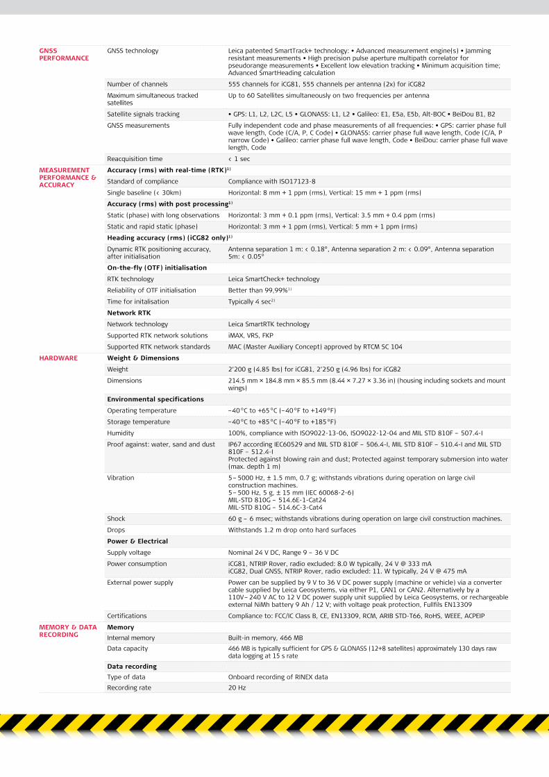
GNSS PERFORMANCE
GNSS technology Leica patented SmartTrack+ technology: • Advanced measurement engine(s) • Jamming resistant measurements • High precision pulse aperture multipath correlator for pseudorange measurements • Excellent low elevation tracking • Minimum acquisition time; Advanced SmartHeading calculation
Number of channels 555 channels for iCG81, 555 channels per antenna (2x) for iCG82
Maximum simultaneous tracked satellites
Up to 60 Satellites simultaneously on two frequencies per antenna
Satellite signals tracking • GPS: L1, L2, L2C, L5 • GLONASS: L1, L2 • Galileo: E1, E5a, E5b, Alt-BOC • BeiDou B1, B2
GNSS measurements Fully independent code and phase measurements of all frequencies: • GPS: carrier phase full wave length, Code (C/A, P, C Code) • GLONASS: carrier phase full wave length, Code (C/A, P narrow Code) • Galileo: carrier phase full wave length, Code • BeiDou: carrier phase full wave length, Code
Reacquisition time < 1 sec
MEASUREMENT PERFORMANCE & ACCURACY
Accuracy (rms) with real-time (RTK)1)
Standard of compliance Compliance with ISO17123-8
Single baseline (< 30km) Horizontal: 8 mm + 1 ppm (rms), Vertical: 15 mm + 1 ppm (rms)
Accuracy (rms) with post processing1)
Static (phase) with long observations Horizontal: 3 mm + 0.1 ppm (rms), Vertical: 3.5 mm + 0.4 ppm (rms)
Static and rapid static (phase) Horizontal: 3 mm + 1 ppm (rms), Vertical: 5 mm + 1 ppm (rms)
Heading accuracy (rms) (iCG82 only)1)
Dynamic RTK positioning accuracy, after initialisation
Antenna separation 1 m: < 0.18°, Antenna separation 2 m: < 0.09°, Antenna separation 5m: < 0.05°
On-the-fly (OTF) initialisation
RTK technology Leica SmartCheck+ technology
Reliability of OTF initialisation Better than 99,99%1)
Time for initalisation Typically 4 sec2)
Network RTK
Network technology Leica SmartRTK technology
Supported RTK network solutions iMAX, VRS, FKP
Supported RTK network standards MAC (Master Auxiliary Concept) approved by RTCM SC 104
HARDWARE Weight & Dimensions
Weight 2’200 g (4.85 lbs) for iCG81, 2’250 g (4.96 lbs) for iCG82
Dimensions 214.5 mm × 184.8 mm × 85.5 mm (8.44 × 7.27 × 3.36 in) (housing including sockets and mount wings)
Environmental specifications
Operating temperature –40 °C to +65 °C (–40 °F to +149 °F)
Storage temperature –40 °C to +85 °C (–40 °F to +185 °F)
Humidity 100%, compliance with ISO9022-13-06, ISO9022-12-04 and MIL STD 810F – 507.4-I
Proof against: water, sand and dust IP67 according IEC60529 and MIL STD 810F – 506.4-I, MIL STD 810F – 510.4-I and MIL STD 810F – 512.4-I Protected against blowing rain and dust; Protected against temporary submersion into water (max. depth 1 m)
Vibration 5 – 5000 Hz, ± 1.5 mm, 0.7 g; withstands vibrations during operation on large civil construction machines. 5 – 500 Hz, 5 g, ± 15 mm (IEC 60068-2-6) MIL-STD 810G – 514.6E-1-Cat24 MIL-STD 810G – 514.6C-3-Cat4
Shock 60 g – 6 msec; withstands vibrations during operation on large civil construction machines.
Drops Withstands 1.2 m drop onto hard surfaces
Power & Electrical
Supply voltage Nominal 24 V DC, Range 9 – 36 V DC
Power consumption iCG81, NTRIP Rover, radio excluded: 8.0 W typically, 24 V @ 333 mA iCG82, Dual GNSS, NTRIP Rover, radio excluded: 11. W typically, 24 V @ 475 mA
External power supply Power can be supplied by 9 V to 36 V DC power supply (machine or vehicle) via a converter cable supplied by Leica Geosystems, via either P1, CAN1 or CAN2. Alternatively by a 110V – 240 V AC to 12 V DC power supply unit supplied by Leica Geosystems, or rechargeable external NiMh battery 9 Ah / 12 V; with voltage peak protection, Fullfils EN13309
Certifications Compliance to: FCC/IC Class B, CE, EN13309, RCM, ARIB STD-T66, RoHS, WEEE, ACPEIP
MEMORY & DATA RECORDING
MemoryInternal memory Built-in memory, 466 MBData capacity 466 MB is typically sufficient for GPS & GLONASS (12+8 satellites) approximately 130 days raw
data logging at 15 s rateData recordingType of data Onboard recording of RINEX dataRecording rate 20 Hz

Leica iCON. Understanding construction.
1) Measurement precision and accuracy in position, height and heading are dependent upon various factors including number of satellites, geometry, observation time, ephemeris accuracy, ionospheric conditions, multipath etc. Figures quoted assume normal to favorable conditions. Times required are dependent upon various factors including
number of satellites, geometry, ionospheric conditions, multipath etc. GPS and GLONASS can increase performance and accuracy by up to 30% relative to GPS only. A full Galileo and GPS L5 constellation will further increase measurement performance and accuracy.
2) Might vary due to atmospheric conditions, signal multipath, obstructions, signal geometry and number of tracked signals.
INTERFACE Buttons • ON / OFF button • 6 Function buttons (arrow keys – up/down/left/right, Enter, Esc)Display High resolution, 1.8" gray scale display with adjustable backlight: • Provides full receiver
status on main screen (position, satellite, radio, modem, battery, Bluetooth®, telematics, memory) • Several submenues for additional details • Various configurations in submenues, e.g. radio channel • Start Base Station with "Here" or type in coordinate • Set up Rover, coordinate system and position output (NMEA or Leica proprietary) • Start and configure raw data logging
LED status indicator 1 × LED for error statusAdditional functionality BasePilot functionality (stores up to different 100 base station locations and configurations
for quick daily start up without user interaction)COMMUNICATION Communication ports 2 × CAN Power/Data, 1 × serial RS232 Lemo, PWR in, PPS out, 1 × serial RS232 Lemo, 12V
PWR out (GFU support) 1 × USB Host, 1 × UART serial & USB (for removable internal RTK devices), 2 × TNC for external GNSS antenna (1 × TNC for iCG81), 1 × TNC for external radio antenna, 1 × TNC for external modem antenna, 1 × M12 Ethernet 1 × Bluetooth® port, Bluetooth® v2.00+ EDR, class 2
Number of simultaneous data links Up to 3 real-time output interfaces via independent ports, providing identical or different RTK/RTCM formats
Built In data linksRadio modems • Optional additional fully integrated, fully sealed receive / transmit radios • User
exchangeable device • SATEL TR4+: 403 – 470 MHz; up to 1.0 W output power; Pac-crest 4FSK, GMSK & FST, Trimble T & P, Satel 3AS, 8FSK & 16FSK modulation • SATEL M3-TR9: 902 – 928 MHz (license free in North America); up to 1.0 W output power
Radio modem antenna External antenna connector (Type TNC)4G LTE / 3G HSPA / HSPA+ / WCDMA / TD-SCDMA / UMTS / Cellular modem
• Built-in cellular modem as default • User exchangeable SIM card • 22-Band LTE: Band 1, 2, 3, 4, 5, 7, 8, 12, 13, 18, 19, 20, 21, 25, 26, 28, 29, 30, 38, 39, 40, 41 • 9-Band UMTS / HSPA / HSPA+ / WCDMA: Band 1, 2, 3, 4, 5, 6, 8, 9, 19 • TD-SCDMA: B39 • Up to 100 mbps downlink speed
4G LTE / 3G HSPA / HSPA+ / WCDMA / TD-SCDMA / UMTS / Cellular modem antenna
External antenna connector (Type TNC)
External data linksRadio modems • Support of any suitable serial RS232 UHF / VHF radios • Satelline3AS in Leica GFU housing,
fully sealed and protected, IP67 • Pacific Crest PDL in Leica GFU housing, fully sealed and protected, IP67 • Satelline TR4, Intuicom 1200DL, TFR-300L in Leica GFU housing, fully sealed and protected, IP67 • Pacific Crest ADL
Communication protocolsReal-time data formats for data transmission
Leica 4G, Leica, CMR, RTCM 3.1, RTCM 3.2 MSM 3 & 5
Real-time data formats for data reception
Leica 4G, Leica, Leica Lite, CMR, CMR+, RTCM v2.3, RTCM 3.1, RTCM 3.2 MSM 3 & 5
Web based protocol NTRIP: receive network corrections; built-in NTRIP Server and Caster to stream local corrections to multiple RTK rovers
NMEA output NMEA 0183 V 4.00 and Leica proprietaryGNSS ANTENNA Type CGA100
GNSS technology SmartTrack+Satellite signals tracking • GPS: L1, L2, L2C, L5 • GLONASS: L1, L2, L3 • Galileo: E1, E5a, E5b, Alt-BOC, E6
• BeiDou B1, B2, B3Ground plane Built-in ground planeDimensions (diameter × height) 165 mm × 60 mm (6.50 × 2.36 in)Weight 0.44 kg (0.97 lbs)Gain 29 dbTemperature operating –40 °C to +85 °C (–40 °F to +185 °F)Temperature storage –55 °C to +85 °C (–67 °F to +185 °F)Humidity IEC60068-2-30
98%r.H./25°C, 93%r.H./55°CProtection against water, sand IP68, IP69KDrops & topple over Withstands 1.5 m drop onto hard surfaces and survives topple over from a 2 m pole onto
hard surfacesVibration IEC 60068-2-6:
5-500 Hz, 15 g, ±15 mmMIL-STD-810G: Fig.514.6E-1Category 24 (20-2000 Hz, 7.7 grms)withstands vibrations during operation on large civil construction machines.
Shock IEC 60068-2-27 (special): 60 g, 6 msIEC 60068-2-27: 100 g, 2 mswithstands vibrations during operation on large civil construction machines.
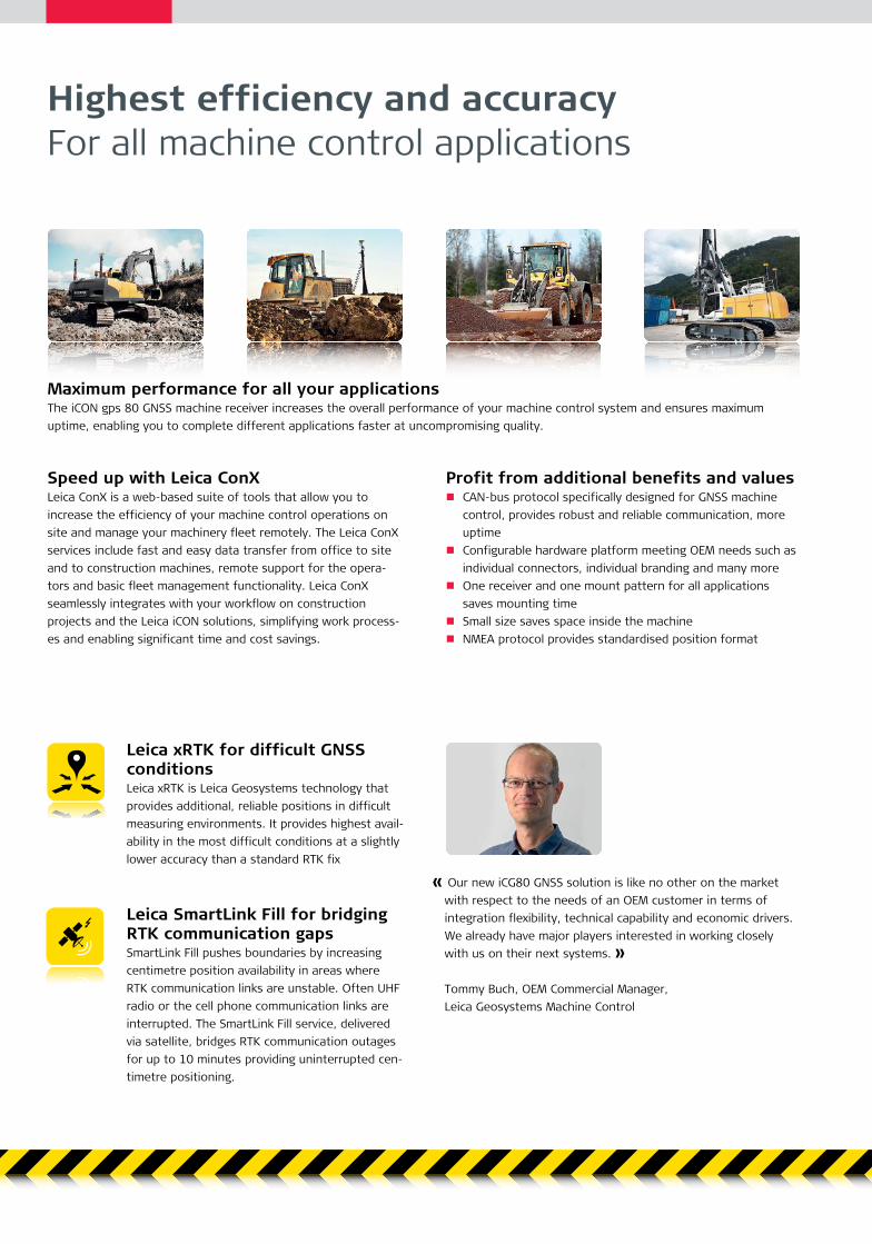
Leica SmartLink Fill for bridging RTK communication gapsSmartLink Fill pushes boundaries by increasing centimetre position availability in areas where RTK communication links are unstable. Often UHF radio or the cell phone communication links are interrupted. The SmartLink Fill service, delivered via satellite, bridges RTK communication outages for up to 10 minutes providing uninterrupted cen-timetre positioning.
Speed up with Leica ConXLeica ConX is a web-based suite of tools that allow you to increase the efficiency of your machine control operations on site and manage your machinery fleet remotely. The Leica ConX services include fast and easy data transfer from office to site and to construction machines, remote support for the opera-tors and basic fleet management functionality. Leica ConX seamlessly integrates with your workflow on construction projects and the Leica iCON solutions, simplifying work process-es and enabling significant time and cost savings.
Maximum performance for all your applicationsThe iCON gps 80 GNSS machine receiver increases the overall performance of your machine control system and ensures maximum uptime, enabling you to complete different applications faster at uncompromising quality.
Leica xRTK for difficult GNSS conditionsLeica xRTK is Leica Geosystems technology that provides additional, reliable positions in difficult measuring environments. It provides highest avail-ability in the most difficult conditions at a slightly lower accuracy than a standard RTK fix
Highest efficiency and accuracy For all machine control applications
Profit from additional benefits and values CAN-bus protocol specifically designed for GNSS machine
control, provides robust and reliable communication, more uptime
Configurable hardware platform meeting OEM needs such as individual connectors, individual branding and many more
One receiver and one mount pattern for all applications saves mounting time
Small size saves space inside the machine NMEA protocol provides standardised position format
« Our new iCG80 GNSS solution is like no other on the market with respect to the needs of an OEM customer in terms of integration flexibility, technical capability and economic drivers. We already have major players interested in working closely with us on their next systems. »
Tommy Buch, OEM Commercial Manager, Leica Geosystems Machine Control

Leica Geosystems AG Heerbrugg, Switzerland
www.leica-geosystems.com
Illustrations, descriptions and technical data are not binding. All rights reserved. Printed in Switzerland – Copyright Leica Geosystems AG, Heerbrugg, Switzerland, 2020. 818210en – 01.21
Leica iCON siteBrochure
Leica iCON gps 70 Series Broch
Leica Geosystems intelligent CONstruction. Whether you construct buildings, roads, bridges or tunnels, you benefit from intelligent CONstruction. Leica iCON is more than a new product line or software package, its a complete solution that enables you to enhance your performance and increase your profitability through perfecting your construction workflow.
Understanding construction demands outstanding solutions: Custom-built Complete Straightforward High performance
When it has to be right.
intel l igent CONstruct ion
The Bluetooth® trade marks areowned by Bluetooth SIG, Inc.
Leica iCON gps 70 series Speed up – anytime, anywhere
leica-geosystems.com
Leica iCON siteCustom-built solutions for site construction
i n t e l l i g e n tC On s t r u c t i o n
Leica ConX Flyer
Leica ConXDigitise your construction process
Leica ConX is a cloud solution and web interface to manage, visualise, aggregate and share 3D construction and survey data in real-time for heavy construction projects.
Digitise your construction process with ConX, a cloud-based suite of tools that harmonises and simplifies the data handling and workflow throughout the phases of the construction process.
Significantly improve productivity and reduce rework and delays caused by inefficiencies or errors in 3D construction data. With ConX, users will be able to visualise and validate reference models, project localisations, positioning, survey and constructed as-built data in real-time and without extensive training.
Benefits ■ Visualise and validate data used and generated on-site in
2D and 3D localised on interactive maps to collaborate and communicate with everyone on site
■ Share updates and corrections to reference model data in real-time across the project to guarantee transparency and quick reaction to design updates
■ Monitor machine control operations remotely by assigning work and providing positioning and reference data to operators and grade checkers ensuring you avoid costly rework and errors