IN TERMS OF THE NATIONAL ENVIRONMENTAL MANAGEMENT …
84
BASIC ASSESSMENT REPORT IN TERMS OF THE EIA REGULATIONS, 2014 (AS AMENDED) – Report date: June 2019 Page 1 of 84 BASIC ASSESSMENT REPORT BASIC ASSESSMENT REPORT IN TERMS OF THE NATIONAL ENVIRONMENTAL MANAGEMENT ACT, 1998 (ACT NO. 107 OF 1998) AND ENVIRONMENTAL IMPACT ASSESSMENT REGULATIONS, 2014 (AS AMENDED) October 2017 PROJECT TITLE PEDESTRIAN PATH TO CONNECT THE HERMANUS CLIFF PATH VIA POOLE’SBAY IN HERMANUS [Report date -June 2019] REPORT TYPE CATEGORY REPORT REFERENCE NUMBER DATE OF REPORT Pre-Application Basic Assessment Report (if applicable) 1 June 2019 Draft Basic Assessment Report 2 Final Basic Assessment Report 3 or, if applicable Revised Basic Assessment Report 4 (strikethrough what is not applicable) Notes: 1. In terms of Regulation 40(3) potential or registered interested and affected parties, including the Competent Authority, may be provided with an opportunity to comment on the Basic Assessment Report prior to submission of the application but must again be provided an opportunity to comment on such reports once an application has been submitted to the Competent Authority. The Basic Assessment Report released for comment prior to submission of the application is referred to as the “Pre-Application Basic Assessment Report”. The Basic Assessment Report made available for comment after submission of the application is referred to as the “Draft Basic Assessment Report”. The Basic Assessment Report together with all the comments received on the report which is submitted to the Competent Authority for decision-making is referred to as the “Final Basic Assessment Report”. 2. In terms of Regulation 19(1)(b) if significant changes have been made or significant new information has been added to the Draft Basic Assessment Report , which changes or information was not contained in the Draft Basic Assessment Report consulted on during the initial public participation process, then a Final Basic Assessment Report will not be submitted, but rather a “Revised Basic Assessment Report”, which must be subjected to another public participation process of at least 30 days, must be submitted to the Competent Authority together with all the comments received.
Transcript of IN TERMS OF THE NATIONAL ENVIRONMENTAL MANAGEMENT …

BASIC ASSESSMENT REPORT IN TERMS OF THE EIA REGULATIONS, 2014 (AS AMENDED) – Report date: June 2019 Page 1 of 84
BASIC ASSESSMENT REPORT
BASIC ASSESSMENT REPORT
IN TERMS OF THE NATIONAL ENVIRONMENTAL MANAGEMENT ACT, 1998 (ACT NO.
107 OF 1998) AND ENVIRONMENTAL IMPACT ASSESSMENT REGULATIONS, 2014 (AS
AMENDED)
October 2017
PROJECT TITLE
PEDESTRIAN PATH TO CONNECT THE HERMANUS CLIFF PATH VIA POOLE’SBAY IN HERMANUS
[Report date -June 2019]
REPORT TYPE CATEGORY REPORT REFERENCE NUMBER DATE OF REPORT Pre-Application Basic Assessment Report (if
applicable)1 June 2019
Draft Basic Assessment Report2 Final Basic Assessment Report3 or, if applicable
Revised Basic Assessment Report4 (strikethrough
what is not applicable)
Notes:
1. In terms of Regulation 40(3) potential or registered interested and affected parties, including the Competent Authority,
may be provided with an opportunity to comment on the Basic Assessment Report prior to submission of the
application but must again be provided an opportunity to comment on such reports once an application has been
submitted to the Competent Authority. The Basic Assessment Report released for comment prior to submission of the
application is referred to as the “Pre-Application Basic Assessment Report”. The Basic Assessment Report made
available for comment after submission of the application is referred to as the “Draft Basic Assessment Report”. The
Basic Assessment Report together with all the comments received on the report which is submitted to the Competent
Authority for decision-making is referred to as the “Final Basic Assessment Report”.
2. In terms of Regulation 19(1)(b) if significant changes have been made or significant new information has been added
to the Draft Basic Assessment Report , which changes or information was not contained in the Draft Basic Assessment
Report consulted on during the initial public participation process, then a Final Basic Assessment Report will not be
submitted, but rather a “Revised Basic Assessment Report”, which must be subjected to another public participation
process of at least 30 days, must be submitted to the Competent Authority together with all the comments received.
BASIC ASSESSMENT REPORT IN TERMS OF THE EIA REGULATIONS, 2014 (AS AMENDED) – Report date: June 2019 Page 2 of 84
DEPARTMENTAL REFERENCE NUMBER(S)
Pre-application reference number: 16/3/3/6/7/1/E2/15/1135/19
File reference number (EIA):
NEAS reference number (EIA):
File reference number (Waste):
NEAS reference number (Waste):
File reference number (Air Quality):
NEAS reference number (Air Quality):
File reference number (Other):
NEAS reference number (Other):
CONTENT AND GENERAL REQUIREMENTS
Note that:
1. The content of the Department’s Circular EADP 0028/2014 (dated 9 December 2014) on the “One Environmental
Management System” and the Environmental Impact Assessment (“EIA”) Regulations, 2014 (as amended), any
subsequent Circulars, and guidelines must be taken into account when completing this Basic Assessment Report Form.
2. This Basic Assessment Report is the standard report format which, in terms of Regulation 16(3) of the EIA Regulations,
2014 (as amended) must be used in all instances when preparing a Basic Assessment Report for Basic Assessment
applications for an environmental authorisation in terms of the National Environmental Management Act, 1998 (Act No.
107 of 1998) (“NEMA”)and the EIA Regulations, 2014 (as amended) and/or a waste management licence in terms of
the National Environmental Management: Waste Act, 2008 (Act No. 59 of 2008) (“NEM:WA”), and/or an atmospheric
emission licence in terms of the National Environmental Management: Air Quality Act, 2004 (Act No. 39 of 2004)
(“NEM:AQA”) when the Western Cape Government: Environmental Affairs and Development Planning (“DEA&DP”) is
the Competent Authority/Licensing Authority.
3. This report form is current as of October 2017. It is the responsibility of the Applicant/ Environmental Assessment
Practitioner (“EAP”) to ascertain whether subsequent versions of the report form have been released by the
Department. Visit the Department’s website at http://www.westerncape.gov.za/eadp to check for the latest version of
this checklist.
4. The required information must be typed within the spaces provided in the form. The size of the spaces provided is not
necessarily indicative of the amount of information to be provided. The tables may be expanded where necessary.
5. The use of “not applicable” in the report must be done with circumspection. All applicable sections of this report form
must be completed. Where “not applicable” is used, this may result in the refusal of the application.
6. While the different sections of the report form only provide space for provision of information related to one alternative,
if more than one feasible and reasonable alternative is considered, the relevant section must be copied and
completed for each alternative.
7. Unless protected by law, all information contained in, and attached to this report, will become public information on
receipt by the competent authority. If information is not submitted with this report due to such information being
protected by law, the applicant and/or EAP must declare such non-disclosure and provide the reasons for believing
that the information is protected.
8. Unless otherwise indicated by the Department, one hard copy and one electronic copy of this report must be
submitted to the Department at the postal address given below or by delivery thereof to the Registry Office of the
Department. Reasonable access to copies of this report must be provided to the relevant Organs of State for
consultation purposes, which may, if so indicated by the Department, include providing a printed copy to a specific
Organ of State.
9. This Report must be submitted to the Department and the contact details for doing so are provided below.
10. Where this Department is also identified as the Licencing Authority to decide applications under NEM:WA or NEM:AQA,
the submission of the Report must also be made as follows, for-
Waste management licence applications, this report must also (i.e., another hard copy and electronic copy) be
submitted for the attention of the Department’s Waste Management Directorate (tel: 021-483-2756 and fax: 021-
483-4425) at the same postal address as the Cape Town Office.
Atmospheric emissions licence applications, this report must also be (i.e., another hard copy and electronic copy)
submitted for the attention of the Licensing Authority or this Department’s Air Quality Management Directorate (tel:
021 483 2798 and fax: 021 483 3254) at the same postal address as the Cape Town Office.

BASIC ASSESSMENT REPORT IN TERMS OF THE EIA REGULATIONS, 2014 (AS AMENDED) – Report date: June 2019 Page 3 of 84
DEPARTMENTAL DETAILS
CAPE TOWN OFFICE GEORGE REGIONAL OFFICE
REGION 1 (City of Cape Town & West Coast District)
REGION 2 (Cape Winelands District & Overberg District)
REGION 3 (Central Karoo District & Eden District)
Department of Environmental Affairs
and Development Planning
Attention: Directorate: Development
Management (Region 1)
Private Bag X 9086
Cape Town,
8000
Registry Office
1st Floor Utilitas Building
1 Dorp Street,
Cape Town
Queries should be directed to the
Directorate: Development
Management (Region 1) at:
Tel.: (021) 483-5829
Fax: (021) 483-4372
Department of Environmental Affairs
and Development Planning
Attention: Directorate: Development
Management (Region 2)
Private Bag X 9086
Cape Town,
8000
Registry Office
1st Floor Utilitas Building
1 Dorp Street,
Cape Town
Queries should be directed to the
Directorate: Development
Management (Region 2) at:
Tel.: (021) 483-5842
Fax: (021) 483-3633
Department of Environmental Affairs
and Development Planning
Attention: Directorate: Development
Management (Region 3)
Private Bag X 6509
George,
6530
Registry Office
4th Floor, York Park Building
93 York Street
George
Queries should be directed to the
Directorate: Development
Management (Region 3) at:
Tel.: (044) 805-8600
Fax: (044) 805 8650
TABLE OF CONTENTS:
Section Page(s)
Section A: Project Information 7
Section B: Description of the Receiving Environment 14
Section C: Public Participation 27
Section D: Need and Desirability 29
Section E: Details of all the Alternatives considered 36
Section F: Environmental Aspects Associated with the Alternatives 39
Section G: Impact Assessment, Impact Avoidance, Management, Mitigation and Monitoring
Measures 47
Section H: Recommendations of the EAP 77
Section I: Appendices 79
Section J: Declarations 80
ACRONYMS USED IN THIS BASIC ASSESSMENT REPORT AND APPENDICES:
BA Basic Assessment
BAR Basic Assessment Report
CBA Critical Biodiversity Area
DEA National Department of Environmental Affairs
DEA&DP Western Cape Government: Environmental Affairs and Development Planning
DWS National Department of Water and Sanitation
EIA Environmental Impact Assessment
EMPr Environmental Management Programme
ESA Ecological Support Area
HWC Heritage Western Cape
I&APs Interested and Affected Parties
NEMA National Environmental Management Act, 1998 (Act No. 107 of 1998)
NEM:ICMA National Environmental Management: Integrated Coastal Management Act, 2008 (Act No. 24 of 2008)
NEM:WA National Environmental Management: Waste Act, 2008 (Act No. 59 of 2008)
NHRA National Heritage Resources Act, 1999 (Act No. 25 of 1999)
PPP Public Participation Process

BASIC ASSESSMENT REPORT IN TERMS OF THE EIA REGULATIONS, 2014 (AS AMENDED) – Report date: June 2019 Page 4 of 84
DETAILS OF THE APPLICANT
Applicant / Organisation /
Organ of State: Cliff Path Action Group
Contact person: Jobre Stassen Postal address: 24 Monmouth Ave, Claremont,
Telephone: Postal Code: 7708 Cellular: 0828964527 Fax:
E-mail: [email protected]
DETAILS OF THE ENVIRONMENTAL ASSESSMENT PRACTITIONER (“EAP”)
Name of the EAP organisation: Ecosense cc Person who compiled this
Report: Kozette Myburgh
EAP Reg. No.: In process Contact Person (if not author): Kozette Myburgh
Postal address: PO Box 1426 Knysna Telephone: (021) 161 0258 Postal Code: 6570
Cellular: 082 783 9860 Fax: (086) 547 4221
E-mail: [email protected]
EAP Qualifications: LL.M Env Law (K Myburgh) / Ndip Nature Conservation (M Sasman) / Btech Landscape Technology (C Rabie)
EAP Registrations Pr Sci Nat (M Sasman) IAIA (K Myburgh) ELA (KMyburgh) IWMSA (Ecosense)
Please provide details of the lead EAP, including details on the expertise of the lead EAP responsible for the Basic
Assessment process. Also attach his/her Curriculum Vitae to this BAR.
Ecosense has been involved in undertaking impact assessments since its establishment in 1998. Our experience in Environmental Authorisation applications is therefore over 20 years. Our staff is adequately qualified to conduct environmental assessment and environmental monitoring and auditing, with postgraduate qualifications in the environmental, legal and development fields, as well as professional scientific registration. The lead EAP for this report is Kozette Myburgh, with over 10 years experience in Environmental Impact Assessment. Relevant applications undertaken previously include (complete list included in attached CV, Appendix K):
Jack Muller and Danie Uys Parks upgrades (Basic Assessment) City of Cape Town
Installation of a Water Main through Gobos River (Basic Assessment) Theewaterskloof Municipality
Flood damage repairs and infrastructure construction at various rivers in Greyton, Caledon and Genadendal (Basic Assessments) Theewaterskloof Municipality
Spier construction of berms and wetland rehabilitation (Basic Assessment) Spier Properties
Greenways Soet River weir (Maintenance Management Plan) Greenways Home Owners Association
Greenways Storm water (coastal ad hoc setback line application) City of Cape Town
Working for Wetland Audits (5 years consecutively) SANBI
Estuary Management Stakeholder workshop facilitation DEA&DP

BASIC ASSESSMENT REPORT IN TERMS OF THE EIA REGULATIONS, 2014 (AS AMENDED) – Report date: June 2019 Page 5 of 84
EXECUTIVE SUMMARY OF THE BASIC ASSESSMENT REPORT:
Ecosense has been appointed as the independent Environmental Assessment Practitioner (EAP) responsible for facilitating the Basic Assessment process for the proposed pedestrian path to connect the existing Hermanus Cliff Path via Poole’s Bay, Hermanus. This process is undertaken in terms of the National Environmental Management Act (NEMA, Act 107 of 1998), Environmental Impact Assessment Regulations as promulgated in December 2014 (as amended). The Applicant is the Cliff Path Action Group, who will facilitate and implement the activity, should it be approved by the Department of Environmental Affairs and Development Planning (DEA&DP). In terms of the NEMA, this proposal requires an application for environmental authorisation for the following listed activities 15, 52, 18, 19 and 19A, through a Basic Assessment process. These activities are concerned with development in or within proximity to water courses and the sea. The current proposal is for a path built in concrete, with a rough aggregate, to encourage staining and seaweed/mussel shell growth. There would be no materials that could be damaged in high storm seas. It would consist of spanning, doweled and stepping stone or slab sections to accommodate the biophysical constraints in this area. The spanning sections will rely on a shifting, reusable formwork profile with replaceable shuttering. Steel-reinforced concrete will allow for spans between concrete column supports, and the rough aggregate surface will be trowelled to achieve an organic, rounded curvature. The doweled sections would follow a similar structural principle, but would be anchored into the existing rock, rather than being supported by columns. The stepping stone / slab sections will be cast in place using an adjustable formwork, which will allow for precise, neat and environmentally friendly pouring. Some sections which are accessible on the beach may only require subtle demarcation for users of the path to refrain from entering private property. Because the walk would mostly be built on the seaward side of the high water mark (HWM), there would be times when it would not be safely accessible, and appropriate signage would be required to advise the public to be aware of sea conditions before using this part of the walk. The NEMA EIA Regulations require a consideration of alternatives to achieve the best practical environmental option for the prosed development. Since the project aims to connect the existing Cliff path by a formalised pedestrian path along Poole’s Bay to ease access and provide safer conditions along this section of the path (as opposed to using the narrow sidewalk along the R44 or clambering over steep rocks in some sections when walking along the shore), there is only one site alternative. The land falls within the coastal public property on the seashore between the HWM and LWM. It is abutted on the landward side by residential properties. In order to avoid encroaching private property, the path (which has been informally used as such in the past) is to follow mostly below the HWM. Currently there are two layout alternatives, which are being informed by the topography of the land:
A path built in concrete with various dowelled, spanning and stepping stone / slab sections following the topography of the coast and erf boundaries as far as possible, which may in some cases, be above the HWM of the sea in Poole’s Bay.
A path built in concrete with various dowelled, spanning and stepping stone / slab sections entirely below the HWM of the sea in Poole’s Bay (except for the connection points to the existing Cliff path, which is above the HWM)
In the case of the ‘no-go’ alternative, no action will be taken to formalise the path and undesirable access and usage conditions will remain. A Notice of Intent to Develop Form was submitted to DEA&DP, Cape Town on 5 April 2019. A freshwater Ecology Screening and Heritage Screening for Notice of Intent to Develop submission to Heritage Western Cape have been undertaken. This report is the first draft (Pre-application Basic Assessment Report (BAR)) for public and authority comment to record and address issues not yet identified.

BASIC ASSESSMENT REPORT IN TERMS OF THE EIA REGULATIONS, 2014 (AS AMENDED) – Report date: June 2019 Page 6 of 84
The Public Participation Process will be carried out in terms of the Environmental Impact Assessment (“EIA”) Regulations, 2014 (as amended), as set out in Chapter 6 of Government Notice No. 326. Steps will be taken to allow ample opportunity for members of the public and key stakeholders to be involved and participate in the application process. The pre-application draft Basic Assessment Report (BAR) will be distributed to relevant authorities for comment, as well as identified stakeholders. Comments received, as well as responses thereto during the pre-application Basic Assessment Report comment period will be incorporated into the draft BAR. Impacts and Mitigation Impacts normally associated with construction activities include disturbance outside construction footprint, noise, littering, etc. In order to mitigate these impacts, specifications have been included in the Environmental Management Programme (EMPr), which must be adhered to. These include:
Demarcated restriction of construction activities site to minimise any potential disturbance to the surrounding area.
Following an integrated waste management approach during construction and operation.
Rehabilitation of disturbed areas must take place after the completion of construction.
Environmental awareness training to construction staff.
Local employment. Operational aspects of the proposed development would be limited to maintenance of infrastructure and signage and waste management along the path. Specifications in the EMPr to address the associated impacts include:
Regular inspection of infrastructure and signage
Regular clean-up of litter along this section of the path The intention of the Applicant is to facilitate safer access to this part of the coast in the least disruptive and most practical way. Due to the locality of this project, no detrimental impacts to the environment or affected parties are expected; on the contrary, this proposed activity will strive to enhance social impacts. The proposal would result in the optimal utilisation of the site with minimal adverse impacts on the ecological environment.
BASIC ASSESSMENT REPORT IN TERMS OF THE EIA REGULATIONS, 2014 (AS AMENDED) – Report date: June 2019 Page 7 of 84
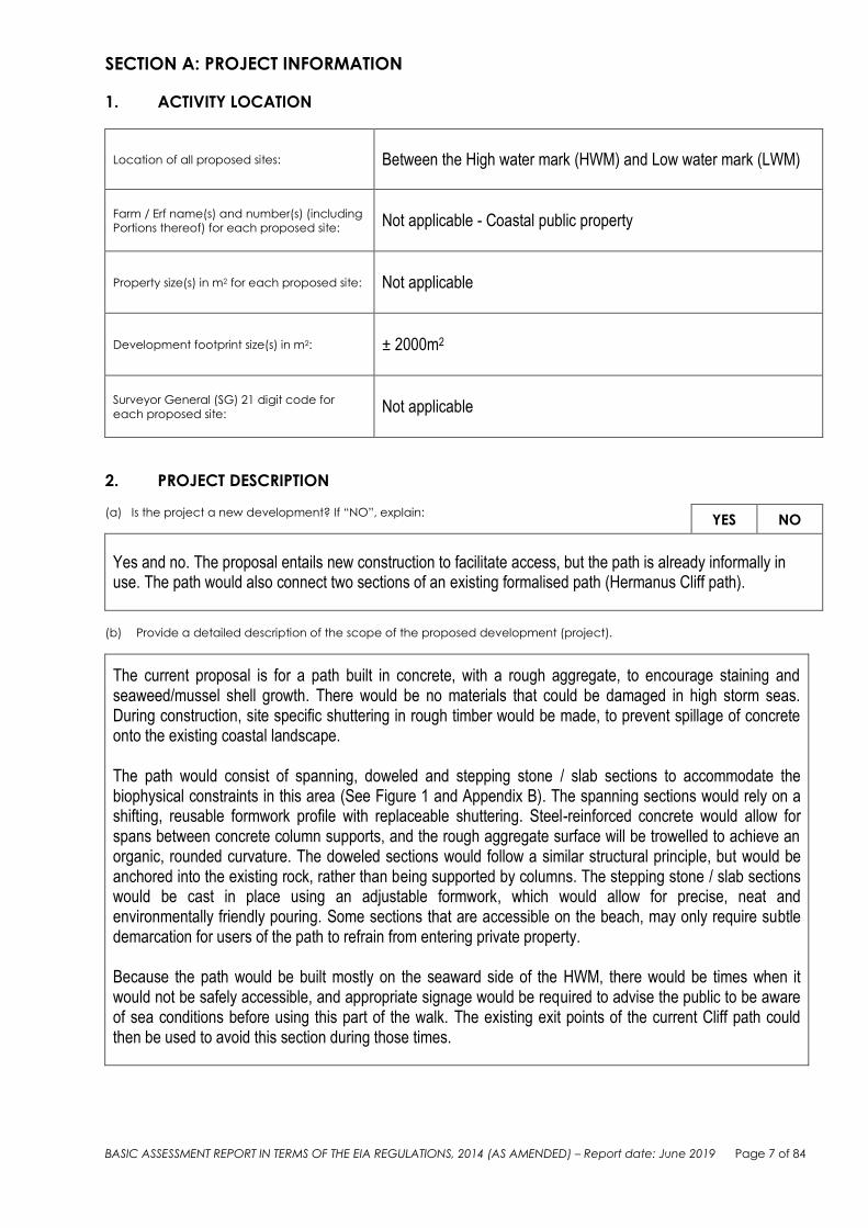
SECTION A: PROJECT INFORMATION
1. ACTIVITY LOCATION
Location of all proposed sites: Between the High water mark (HWM) and Low water mark (LWM)
Farm / Erf name(s) and number(s) (including
Portions thereof) for each proposed site: Not applicable - Coastal public property
Property size(s) in m2 for each proposed site: Not applicable
Development footprint size(s) in m2:
± 2000m2
Surveyor General (SG) 21 digit code for
each proposed site: Not applicable
2. PROJECT DESCRIPTION
(a) Is the project a new development? If “NO”, explain:
YES NO
Yes and no. The proposal entails new construction to facilitate access, but the path is already informally in use. The path would also connect two sections of an existing formalised path (Hermanus Cliff path).
(b) Provide a detailed description of the scope of the proposed development (project).
The current proposal is for a path built in concrete, with a rough aggregate, to encourage staining and seaweed/mussel shell growth. There would be no materials that could be damaged in high storm seas. During construction, site specific shuttering in rough timber would be made, to prevent spillage of concrete onto the existing coastal landscape.
The path would consist of spanning, doweled and stepping stone / slab sections to accommodate the biophysical constraints in this area (See Figure 1 and Appendix B). The spanning sections would rely on a shifting, reusable formwork profile with replaceable shuttering. Steel-reinforced concrete would allow for spans between concrete column supports, and the rough aggregate surface will be trowelled to achieve an organic, rounded curvature. The doweled sections would follow a similar structural principle, but would be anchored into the existing rock, rather than being supported by columns. The stepping stone / slab sections would be cast in place using an adjustable formwork, which would allow for precise, neat and environmentally friendly pouring. Some sections that are accessible on the beach, may only require subtle demarcation for users of the path to refrain from entering private property.
Because the path would be built mostly on the seaward side of the HWM, there would be times when it would not be safely accessible, and appropriate signage would be required to advise the public to be aware of sea conditions before using this part of the walk. The existing exit points of the current Cliff path could then be used to avoid this section during those times.

BASIC ASSESSMENT REPORT IN TERMS OF THE EIA REGULATIONS, 2014 (AS AMENDED) – Report date: June 2019 Page 8 of 84
Figure 1: Schematic drawings of proposed structures (see Appendix B for enlarged drawings)
Please note: This description must relate to the listed and specified activities in paragraph (d) below.
(c) Please indicate the following periods that are recommended for inclusion in the environmental authorisation:
(i) the period within which
commencement must occur,
It is recommended that the activity commences within three years of the date of authorisation. Funding and contractor procurement would need to be secured before construction could commence. Construction should be undertaken in the summer months of the selected year. Anything later will be a challenge during the rainy season, when the sea is also at its highest. The selection of capable contractors will be important since delays to lack of ability will push the project into the rain season with major programme consequences.
(ii) the period for which the
environmental authorisation
should be granted and the
date by which the activity
must have been concluded,
where the environmental
authorisation does not include
operational aspects;
Three years should be sufficient to obtain finance, commence and conclude the construction activities. It must however be noted that the maintenance activities would be ongoing and a specific period cannot be allocated.
(iii) the period that should be
granted for the non-
It is assumed that non-operational aspects refer to the

BASIC ASSESSMENT REPORT IN TERMS OF THE EIA REGULATIONS, 2014 (AS AMENDED) – Report date: June 2019 Page 9 of 84
operational aspects of the
environmental authorisation;
and
construction period. A period of three years should be sufficient to commence and complete the construction activities to cover financing, procurement and seasonal aspects.
(iv) the period that should be
granted for the operational
aspects of the environmental
authorisation.
As the structure would require ongoing (albeit minimal) maintenance, no specific period can be allocated as this application is seeking to authorise also an ongoing maintenance management plan.
Please note: The Department must specify the abovementioned periods, where applicable, in an environmental
authorisation. In terms of the period within which commencement must occur, the period must not exceed 10 years
and must not be extended beyond such 10 year period, unless the process to amend the environmental authorisation
contemplated in regulation 32 is followed.
(d) List all the listed activities triggered and being applied for.
Please note: The onus is on the applicant to ensure that all the applicable listed activities are applied for and assessed
as part of the EIA process. Please refer to paragraph (b) above.
EIA Regulations Listing Notices 1 and 3 of 2014 (as amended):
Listed
Activity
No(s):
Describe the relevant Basic
Assessment Activity(ies) in
writing as per Listing Notice 1
(GN No. R. 327)
Describe the portion of the
development that relates to the
applicable listed activity as per the
project description.
Identify if the activity is
development / development and
operational / decommissioning /
expansion / expansion and
operational.
15, 52
The development or expansion of structures in the coastal public property where the development footprint is bigger than 50 square metres
The proposed pathway would exceed 50 m2.
Development / expansion and Operational
18
The planting of vegetation or placing of any material on dunes or exposed sand surfaces of more than 10 square metres, within the littoral active zone, for the purpose of preventing the free movement of sand, erosion or accretion
The proposed pathway would entail the placement of concrete on more than 10m2 exposed sand surfaces within the littoral active zone in order to provide safe access for pedestrians, hence preventing the free movement of sand, erosion or accretion in these areas
Development
19
The infilling or depositing of any material of more than 10 cubic metres into, or the dredging, excavation, removal or moving of soil, sand, shells, shell grit, pebbles or rock of more than 10 cubic metres from a watercourse
The pathway will cross a small stream flowing into the sea and may entail the disturbance of more than 10 cubic metres, depending on the design of the path at this point. It is highly unlikely though, as the area to be crossed will only impact on approximately 5m2 surface area. Therefore, this activity will only be triggered if excavations required
Development

BASIC ASSESSMENT REPORT IN TERMS OF THE EIA REGULATIONS, 2014 (AS AMENDED) – Report date: June 2019 Page 10 of
84
are more than 2m deep.
19A
The infilling or depositing of any material of more than 5 cubic metres into, or the dredging, excavation, removal or moving of soil, sand, shells, shell grit, pebbles or rock of more than 10 cubic metres from the seashore
Construction activities would necessitate the infilling or depositing of more than 5 m3 of pebbles and grit within the seashore, as the pathway would be more than 800m long.
Development
Listed
Activity
No(s):
Describe the relevant Basic
Assessment Activity(ies) in
writing as per Listing Notice 3
(GN No. R. 324)
Describe the portion of the
development that relates to the
applicable listed activity as per the
project description.
Identify if the activity is
development / development and
operational / decommissioning /
expansion / expansion and
operational.
N.A. – although Activity 12 was considered, it is our opinion that it would not be required, as the path would be located below the HWM of the sea, where there is no vegetation to be cleared.
Waste management activities in terms of the NEM: WA (GN No. 921):
Category A
Listed
Activity
No(s):
Describe the relevant
Category A waste
management activity in
writing as per GN No. 921
Describe the portion of the development that relates to the applicable listed
activity as per the project description
Not applicable to this application.
Note: If any waste management activities are applicable, the Listed Waste Management Activities Additional
Information Annexure must be completed and attached to this Basic Assessment Report as Appendix I.
Atmospheric emission activities in terms of the NEM: AQA (GN No. 893):
Listed
Activity
No(s):
Describe the relevant
atmospheric emission activity
in writing as per GN No. 893
Describe the portion of the development that relates to the applicable listed
activity as per the project description.
Not applicable to this application.
(e) Provide details of all components (including associated structures and infrastructure) of the proposed development
and attach diagrams (e.g., architectural drawings or perspectives, engineering drawings, process flowcharts, etc.).
Buildings
Provide brief description below: YES NO
Not applicable. Infrastructure (e.g., roads, power and water supply/ storage)
Provide brief description below: YES NO
The proposal is for a path built in concrete that would consist of spanning, doweled and stepping stone / slab sections to accommodate the biophysical constraints in the area. It would however not require municipal service infrastructure.
BASIC ASSESSMENT REPORT IN TERMS OF THE EIA REGULATIONS, 2014 (AS AMENDED) – Report date: June 2019 Page 11 of
84
Processing activities (e.g., manufacturing, storage, distribution)
Provide brief description below: YES NO
Storage facilities for raw materials and products (e.g., volume and substances to be stored)
Provide brief description below: YES NO
Storage and treatment facilities for effluent, wastewater or sewage:
Provide brief description below: YES NO
Storage and treatment of solid waste
Provide brief description below: YES NO
Facilities associated with the release of emissions or pollution.
Provide brief description below: YES NO
Other activities (e.g., water abstraction activities, crop planting activities) –
Provide brief description below: YES NO
3. PHYSICAL SIZE OF THE PROPOSED DEVELOPMENT
(a) Property size(s): Indicate the size of all the properties (cadastral units) on which
the development proposal is to be undertaken m2
(b) Size of the facility: Indicate the size of the facility where the development
proposal is to be undertaken Maximum 2000 m2 m2
(c) Development footprint: Indicate the area that will be physically altered as a
result of undertaking any development proposal (i.e., the physical size of the
development together with all its associated structures and infrastructure)
The total development footprint is proposed to be maximum 2000 m2.
m2
(d) Size of the activity: Indicate the physical size (footprint) of the development
proposal
The total development footprint is proposed to be maximum 2000 m2.
m2
(e) For linear development proposals: Indicate the length (L) and width (W) of the
development proposal
(L) ±850 m
(W)±2m m
(f) For storage facilities: Indicate the volume of the storage facility N.a. m3
(g) For sewage/effluent treatment facilities: Indicate the volume of the facility
(Note: the maximum design capacity must be indicated N.a. m3
4. SITE ACCESS
(a) Is there an existing access road? YES NO
(b) If no, what is the distance in (m) over which a new access road will be built? None will be built
(c) Describe the type of access road planned:
Not applicable
Please note: The position of the proposed access road must be indicated on the site plan.

BASIC ASSESSMENT REPORT IN TERMS OF THE EIA REGULATIONS, 2014 (AS AMENDED) – Report date: June 2019 Page 12 of
84
5. DESCRIPTION OF THE PROPERTY(IES) ON WHICH THE LISTED Activity(IES) ARE TO BE
UNDERTAKEN AND THE LOCATION OF THE LISTED ACTIVITY(IES) ON THE PROPERTY
5.1 Provide a description of the property on which the listed activity(ies) is/are to be undertaken and the location of the
listed activity(ies) on the property, as well as of all alternative properties and locations (duplicate section below as
required).
The property on which the activity is to be undertaken is coastal public property in the area of Poole’s Bay, Hermanus.
Coordinates of all the proposed activities
on the property or properties (sites):
See 5.3 below
Latitude (S): (deg.; min.; sec) Longitude (E): (deg.; min.; sec.)
° ΄ " o ‘ “
° ‘ “ o ‘ “
° ‘ “ o ‘ “
° ‘ “ o ‘ “
Note: For land where the property has not been defined, the coordinates of the area within which the development is
proposed must be provided in an addendum to this report.
5.2 Provide a description of the area where the aquatic or ocean-based activity(ies) is/are to be undertaken and the
location of the activity(ies) and alternative sites (if applicable).
Not applicable
Coordinates of the boundary /perimeter of
all proposed aquatic or ocean-based
activities (sites) (if applicable):
Latitude (S): (deg.; min.; sec) Longitude (E): (deg.; min.; sec)
° ' " o ' "
° ' " o ' "
° ' " o ' "
° ' " o ' "
5.3 For a linear development proposal, please provide a description and coordinates of the corridor in which the
proposed development will be undertaken (if applicable).
Although falling within one property, i.e. coastal public property, the development is regarded as linear, since it is a pathway of over 800m long.
For linear activities: Latitude (S): (deg.; min.; sec) Longitude (E): (deg.; min.; sec)
Starting point of the activity (west) 34°24'55.79"S 19°14'59.33"E Middle point of the activity 34°24'48.15"S 19°15'6.26"E End point of the activity (east) 34°24'46.03"S 19°15'19.22"E
Note: For linear development proposals longer than 1000m, please provide an addendum with co-ordinates taken every
250m along the route. All important waypoints must be indicated and the GIS shape file provided digitally.
5.4 Provide a location map (see below) as Appendix A to this report that shows the location of the proposed
development and associated structures and infrastructure on the property; as well as a detailed site development
plan / site map (see below) as Appendix B to this report; and if applicable, all alternative properties and locations. The
GIS shape files (.shp) for maps / site development plans must be included in the electronic copy of the report
submitted to the competent authority.
Locality
Map:
The scale of the locality map must be at least 1:50 000.
For linear development proposals of more than 25 kilometres, a smaller scale e.g., 1:250 000 can be used.
The scale must be indicated on the map.
The map must indicate the following:
an accurate indication of the project site position as well as the positions of the alternative sites, if any;
road names or numbers of all the major roads as well as the roads that provide access to the site(s)
a north arrow;
a legend;

BASIC ASSESSMENT REPORT IN TERMS OF THE EIA REGULATIONS, 2014 (AS AMENDED) – Report date: June 2019 Page 13 of
84
a linear scale;
the prevailing wind direction (during November to April and during May to October); and
GPS co-ordinates (to indicate the position of the activity using the latitude and longitude of the centre
point of the site for each alternative site. The co-ordinates should be in degrees and decimal minutes.
The minutes should have at least three decimals to ensure adequate accuracy. The projection that
must be used in all cases is the WGS84 spheroid in a national or local projection).
For an ocean-based or aquatic activity, the coordinates must be provided within which the activity is to be
undertaken and a map at an appropriate scale clearly indicating the area within which the activity is to be
undertaken.
Coordinates must be provided in degrees, minutes and seconds using the Hartebeesthoek94; WGS84 co-
ordinate system.
Site Plan:
Detailed site development plan(s) must be prepared for each alternative site or alternative activity. The site
plans must contain or conform to the following:
The detailed site plan must preferably be at a scale of 1:500 or at an appropriate scale. The scale must
be indicated on the plan, preferably together with a linear scale.
The property boundaries and numbers of all the properties within 50m of the site must be indicated on
the site plan.
The current land use (not zoning) as well as the land use zoning of each of the adjoining properties must
be indicated on the site plan.
The position of each element of the application as well as any other structures on the site must be
indicated on the site plan.
Services, including electricity supply cables (indicate aboveground or underground), water supply
pipelines, boreholes, sewage pipelines, storm water infrastructure and access roads that will form part
of the development must be indicated on the site plan.
Servitudes and an indication of the purpose of each servitude must be indicated on the site plan.
Sensitive environmental elements within 100m of the site must be included on the site plan, including
(but not limited to):
o Watercourses / Rivers / Wetlands - including the 32 meter set back line from the edge of the bank
of a river/stream/wetland;
o Flood lines (i.e., 1:100 year, 1:50 year and 1:10 year where applicable;
o Ridges;
o Cultural and historical features;
o Areas with indigenous vegetation (even if degraded or infested with alien species).
Whenever the slope of the site exceeds 1:10, a contour map of the site must be submitted.
North arrow
A map/site plan must also be provided at an appropriate scale, which superimposes the proposed
development and its associated structures and infrastructure on the environmental sensitivities of the
preferred and alternative sites indicating any areas that should be avoided, including buffer areas.
The GIS shape file for the site development plan(s) must be submitted digitally.
6. SITE PHOTOGRAPHS
Colour photographs of the site and its surroundings (taken on the site and taken from outside the site) with a description of
each photograph. The vantage points from which the photographs were taken must be indicated on the site plan, or
locality plan as applicable. If available, please also provide a recent aerial photograph. Photographs must be attached as
Appendix C to this report. The aerial photograph(s) should be supplemented with additional photographs of relevant
features on the site. Date of photographs must be included. Please note that the above requirements must be duplicated
for all alternative sites.
EAPS note: Some photographs have been repeated in the body of this document for ease of reference in the immediate context of the discussion.
BASIC ASSESSMENT REPORT IN TERMS OF THE EIA REGULATIONS, 2014 (AS AMENDED) – Report date: June 2019 Page 14 of
84
SECTION B: DESCRIPTION OF THE RECEIVING ENVIRONMENT
SITE/AREA DESCRIPTION
For linear development proposals (pipelines, etc.) as well as development proposals that cover very large sites, it may be
necessary to complete copies of this section for each part of the site that has a significantly different environment. In such
cases please complete copies of Section B and indicate the area that is covered by each copy on the Site Plan.
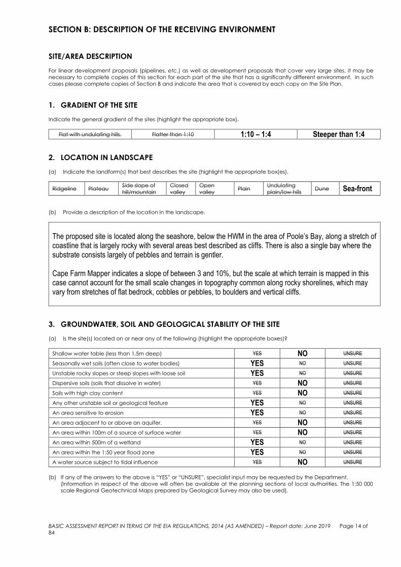
1. GRADIENT OF THE SITE
Indicate the general gradient of the sites (highlight the appropriate box).
Flat with undulating hills. Flatter than 1:10 1:10 – 1:4 Steeper than 1:4
2. LOCATION IN LANDSCAPE
(a) Indicate the landform(s) that best describes the site (highlight the appropriate box(es).
Ridgeline Plateau Side slope of
hill/mountain
Closed
valley
Open
valley Plain
Undulating
plain/low hills Dune Sea-front
(b) Provide a description of the location in the landscape.
The proposed site is located along the seashore, below the HWM in the area of Poole’s Bay, along a stretch of coastline that is largely rocky with several areas best described as cliffs. There is also a single bay where the substrate consists largely of pebbles and terrain is gentler. Cape Farm Mapper indicates a slope of between 3 and 10%, but the scale at which terrain is mapped in this case cannot account for the small scale changes in topography common along rocky shorelines, which may vary from stretches of flat bedrock, cobbles or pebbles, to boulders and vertical cliffs.
3. GROUNDWATER, SOIL AND GEOLOGICAL STABILITY OF THE SITE
(a) Is the site(s) located on or near any of the following (highlight the appropriate boxes)?
Shallow water table (less than 1.5m deep) YES NO UNSURE
Seasonally wet soils (often close to water bodies) YES NO UNSURE
Unstable rocky slopes or steep slopes with loose soil YES NO UNSURE
Dispersive soils (soils that dissolve in water) YES NO UNSURE
Soils with high clay content YES NO UNSURE
Any other unstable soil or geological feature YES NO UNSURE
An area sensitive to erosion YES NO UNSURE
An area adjacent to or above an aquifer. YES NO UNSURE
An area within 100m of a source of surface water YES NO UNSURE
An area within 500m of a wetland YES NO UNSURE
An area within the 1:50 year flood zone YES NO UNSURE
A water source subject to tidal influence YES NO UNSURE
(b) If any of the answers to the above is “YES” or “UNSURE”, specialist input may be requested by the Department.
(Information in respect of the above will often be available at the planning sections of local authorities. The 1:50 000
scale Regional Geotechnical Maps prepared by Geological Survey may also be used).

BASIC ASSESSMENT REPORT IN TERMS OF THE EIA REGULATIONS, 2014 (AS AMENDED) – Report date: June 2019 Page 15 of
84
(c) Indicate the type of geological formation underlying the site.
Granite Shale Sandstone Quartzite Dolomite Dolerite Other
(describe)
Provide a description.
Limestone, sandstone, conglomerate, quarzitic sandstone, minor shale, unconsolidated dune sand.
4. SURFACE WATER
(a) Indicate the surface water present on and or adjacent to the site and alternative sites (highlight the appropriate
boxes)?
Perennial River YES NO UNSURE
Non-Perennial River YES NO UNSURE
Permanent Wetland YES NO UNSURE
Seasonal Wetland YES NO UNSURE
Artificial Wetland YES NO UNSURE
Estuarine / Lagoon YES NO UNSURE
(b) Provide a description.
According to the Freshwater Ecology screening, no rivers, streams or drainage lines were indicated within the development footprint by desktop resources. The National Freshwater Ecosystem Priority Areas (NFEPA) (2011) indicates two large wetland systems to the north of the proposed site. The two wetlands are also at a higher elevation, over 100m away from the proposed site and separated by a suburban area. It is therefore the opinion of the specialist that there is no risk to these two wetlands from the proposed development. The Western Cape Biodiversity Spatial Plan (WCBSP) (2017) indicates a single freshwater feature falling just within the proposed site and classed partially as an aquatic Ecological Support Area (ESA) class 1, and also as an aquatic ESA class 2. ESA’s are areas that are required to support the functioning of Critical Biodiversity Areas (CBA’s) which are essential in averting loss of biodiversity. ESA class 1 is in good ecological condition, while an ESA class 2 requires rehabilitation. The WCBSP (2017) also indicates that the easternmost portion of the proposed path would most likely fall within the Fernkloof Nature Reserve. Two small unmapped wetlands were identified and delineated within the proposed site. The wetlands were dominated by hydrophytic vegetation. Hand augering was conducted and wetland soil indicators were noted at both wetlands. Wetland 1 was classified as a channelled valley bottom wetland (which becomes a stream when it reaches the beach), while Wetland 2 was classified as a hillslope seep (See Figure below). Also found was a discharge point of an extremely old collapsed concrete pipe that carries water of unknown origins into the ocean. The water currently spills out onto a small rocky beach but cannot be considered a watercourse as it is entirely of unnatural origin and would not flow over the beach if the pipe were fixed (Enviroswift, 2019).

BASIC ASSESSMENT REPORT IN TERMS OF THE EIA REGULATIONS, 2014 (AS AMENDED) – Report date: June 2019 Page 16 of
84
Figure 2: Delineated wetlands within proposed site (Enviroswift, 2019)
5. THE SEAFRONT / SEA (a) Is the site(s) located within any of the following areas? (highlight the appropriate boxes).
If the site or alternative site is closer than 100m to such an area, please provide the approximate distance in (m).
AREA YES NO UNSURE If “YES”: Distance to
nearest area (m)
An area within 100m of the high water mark of the sea YES NO UNSURE Just below the
HWM An area within 100m of the high water mark of an estuary/lagoon YES NO UNSURE An area within the littoral active zone YES NO UNSURE An area in the coastal public property YES NO UNSURE Major anthropogenic structures YES NO UNSURE An area within a Coastal Protection Zone YES NO UNSURE An area seaward of the coastal management line YES NO UNSURE An area within the high risk zone (20 years) YES NO UNSURE An area within the medium risk zone (50 years) YES NO UNSURE An area within the low risk zone (100 years) YES NO UNSURE An area below the 5m contour YES NO UNSURE An area within 1km from the high water mark of the sea YES NO UNSURE A rocky beach YES NO UNSURE A sandy beach YES NO UNSURE
(b) If any of the answers to the above is “YES” or “UNSURE”, specialist input may be requested by the Department. (The
1:50 000 scale Regional Geotechnical Maps prepared by Geological Survey may also be used).
The shoreline areas of the Overberg coastline are rugged and characterized by a range of habitats including rocky headlands, boulder beaches, wave cut platforms, sandy beaches, subtidal soft sediment habitats, pocket beaches, kelp forests, estuaries, sub tidal reefs and pelagic habitat (DEA&DP 2015:2). The Poole’s Bay area in particular consists mostly of rocky outcrops (as also indicated on the topographical map in

BASIC ASSESSMENT REPORT IN TERMS OF THE EIA REGULATIONS, 2014 (AS AMENDED) – Report date: June 2019 Page 17 of
84
Appendix A), but some small gravel coves and pebble beaches with kelp washed up in many places are also found along the connection path.
Figure 3: Rocky outcrops
Figure 4: Gravel in small coves
Figure 5: Pebble beach
Figure 6: Tidal pool and pebbles / gravel
During 2010, a study to inform development setback for the Overberg District was undertaken, which also informed the DEA&DP Coastal Management Programme (2015). The Overberg Coastal Set-backs project involved delineating realistic coastal set-back line(s) (or coastal management lines / CMS1) in addition to the modelled maximum risk line. The management lines would then translate long term (e.g. 100 year) natural processes modelling into guidance that relates to pragmatic planning horizons (e.g. 50 year structural life expectancy). The project culminated in the designation of three conceptual lines or zones:
A broad Coastal Protection Zone extending to the landward boundary of sensitive coastal features in addition to the maximum modelled coastal risk zone, within which limited management control was required
A Physical Processes Zone2 which demarcated the output of the rigorous scientific modelling process used to project future coastal risk
A Draft Overberg Coastal Set-back Line which designated a narrow band of high risk area along the shoreline within which strict management controls are to be applied
1 Coastal Management line (CMA) means a line determined in accordance with section 25 of the NEMICMA, as amended, in order to demarcate an area within which development will be prohibited or controlled in order to achieve the objects of the Act or coastal management objectives 2 A physical process / hazard line is intended to define the limit of the coastal area seaward of which any development is likely to experience
unacceptable risk of erosion, flooding by wave action and/or unacceptable maintenance of windblown sand accumulations.

BASIC ASSESSMENT REPORT IN TERMS OF THE EIA REGULATIONS, 2014 (AS AMENDED) – Report date: June 2019 Page 18 of
84
Figure 7: Schematic representation of Overberg District Coastal Set-Back Lines concept (source –
DEA&DP 2015:11) The Coastal Management line is an important factor to consider in any development application. For Overstrand in this particular location, it follows the edge of the 13 properties along Poole’s Bay, as indicated in Figure 8 below.
Figure 8: Coastal Management line in Poole’s Bay area
6. BIODIVERSITY
Note: The Department may request specialist input/studies depending on the nature of the biodiversity occurring on
the site and potential impact(s) of the proposed development. To assist with the identification of the biodiversity
occurring on site and the ecosystem status, consult http://bgis.sanbi.org or [email protected] . Information is
also available on compact disc (“cd”) from the Biodiversity-GIS Unit, Tel.: (021) 799 8698. This information may be
updated from time to time and it is the applicant/ EAP’s responsibility to ensure that the latest version is used. A
map of the relevant biodiversity information (including an indication of the habitat conditions as per (b) below)
must be provided as an overlay map on the property/site plan as Appendix D to this report.

BASIC ASSESSMENT REPORT IN TERMS OF THE EIA REGULATIONS, 2014 (AS AMENDED) – Report date: June 2019 Page 19 of
84
(a) Highlight the applicable biodiversity planning categories of all areas on preferred and alternative sites and indicate the
reason(s) provided in the biodiversity plan for the selection of the specific area as part of the specific category. Also
describe the prevailing level of protection of the Critical Biodiversity Area (“CBA”) and Ecological Support Area (“ESA”)
(how many hectares / what percentages are formally protected).
Systematic Biodiversity Planning Category CBA ESA Other Natural
Area (“ONA”)
No Natural Area
Remaining
(“NNR”)
If CBA or ESA, indicate the reason(s) for its
selection in biodiversity plan and the
conservation management objectives
Although the proposed path would likely fall within the CBA that is indicated along this stretch of coastline, it is not indicated as such on the WCBSP, as the site falls below the HWM, where very little vegetation is found.
Describe the site’s CBA/ESA quantitative
values (hectares/percentage) in relation to
the prevailing level of protection of CBA and
ESA (how many hectares / what percentages
are formally protected locally and in the
province)
Not applicable, since the site is not formally part of the CBA.
(b) Highlight and describe the habitat condition on site.
Habitat Condition
Percentage of habitat
condition class
(adding up to 100%)
and area of each in
square metre (m2)
Description and additional comments and observations (including additional insight into condition, e.g. poor land management practises,
presence of quarries, grazing/harvesting regimes, etc.)
EAPs Note: Because the site falls within the coastal public property, which is not a quantifiable site, it is limited for the purposes of this explanation to the proposed development footprint, which is approximately 2000m2
Natural 95% 1900m2
This area along the coastline below the HWM has not been significantly disturbed and although there is not much vegetation on the proposed development footprint due to the local tidal conditions, it can be regarded as mostly natural habitat.
Near Natural
(includes areas with
low to moderate
level of alien
invasive plants)
% m2
As far as could be determined, there is no alien invasive plants on the seashore
Degraded
(includes areas
heavily invaded by
alien plants)
% m2
No area on the seashore has been developed before, apart from two pipelines going out to sea, but the footprint is minimal. As far as could be determined, there is no alien invasive plants on the seashore. The area cannot be regarded as degraded.
Transformed
(includes
cultivation, dams,
urban, plantation,
roads, etc)
5% 100m2
The tidal pool, old pipelines and some associated disturbance would be the only areas where this area of coastline has been transformed.
(c) Complete the table to indicate:
(i) the type of vegetation present on the site, including its ecosystem status; and
(ii) whether an aquatic ecosystem is present on/or adjacent to the site.
Terrestrial Ecosystems Description of Ecosystem, Vegetation Type, Original Extent, Threshold (ha,
%), Ecosystem Status
Ecosystem threat status as per
the National Environmental
Management: Biodiversity Act,
2004 (Act No. 10 of 2004)
Critically According to the National Vegetation Map (2012), the vegetation type occurring in proximity to the site is Overberg Sandstone
Endangered
Vulnerable

BASIC ASSESSMENT REPORT IN TERMS OF THE EIA REGULATIONS, 2014 (AS AMENDED) – Report date: June 2019 Page 20 of
84
Least
Threatened
Fynbos with conservation status of Critically Endangered. A stretch of a degraded Critical Biodiversity Area is indicated along the seaward border of the first nine properties, but upon site visit, there were not much vegetation found outside the boundaries of these properties, as a result of tidal action. The WCBSP also indicates very little areas of natural vegetation left along this stretch.
Aquatic Ecosystems
Wetland (including rivers, depressions,
channelled and unchannelled wetlands, flats,
seeps pans, and artificial wetlands)
Estuary Coastline
YES NO UNSURE YES NO YES NO
(d) Provide a description of the vegetation type and/or aquatic ecosystem present on the site, including any important
biodiversity features/information identified on the site (e.g. threatened species and special habitats). Clearly describe
the biodiversity targets and management objectives in this regard.
The vegetation type occurring in proximity to the site is Overberg Sandstone Fynbos (FFs12). According to the Municipality’s Environmental Management Framework (EMF), the chief classification criterion is D1: ≥ 80 threatened Red Data List plant species. Remaining natural area is 86%, of which 6 % is formally conserved. The national conservation target is 30%.
The area next to the site is marked as a CBA2, which means it falls within a Core 1 Spatial Planning Category according to the EMF. Management objectives for Core 1 SPC’s include conserving and maintaining natural areas and to rehabilitate land where degraded.
The scope of the project and its locality would not compromise any of these targets or management objectives.
Wetlands associated with the proposed site fall within the Southwest Sandstone Fynbos wetland vegetation group (also Critically Endangered) as defined by the National Freshwater Ecosystem Priority Areas database (Enviroswift, 2019).
7. LAND USE OF THE SITE
Note: The Department may request specialist input/studies depending on the nature of the land use character of the
area and potential impact(s) of the proposed development.
Untransformed area Low density
residential Medium density residential High density residential Informal residential
Retail Commercial &
warehousing Light industrial Medium industrial Heavy industrial
Power station Office/consulting
room
Military or police
base/station/compound
Casino/entertainment
complex
Tourism &
Hospitality facility
Open cast mine Underground mine Spoil heap or slimes dam Quarry, sand or borrow
pit Dam or reservoir
Hospital/medical
center School Tertiary education facility Church Old age home
Sewage treatment
plant
Train station or
shunting yard Railway line
Major road (4 lanes or
more) Airport
Harbour Sport facilities Golf course Polo fields Filling station
Landfill or waste
treatment site Plantation Agriculture
River, stream or wetland
Nature
conservation area
Mountain, koppie or
ridge Museum Historical building Graveyard
Archeological site
Other land uses
(describe): Coastal public property

BASIC ASSESSMENT REPORT IN TERMS OF THE EIA REGULATIONS, 2014 (AS AMENDED) – Report date: June 2019 Page 21 of
84
(a) Provide a description.
The site falls on the seashore (except for western and eastern areas where connecting to the existing Cliff path), below the HWM of the sea and therefore mostly within coastal public property.
8. LAND USE CHARACTER OF THE SURROUNDING AREA
(a) Highlight the current land uses and/or prominent features that occur within +/- 500m radius of the site and
neighbouring properties if these are located beyond 500m of the site.
Note: The Department may request specialist input/studies depending on the nature of the land use character of
the area and potential impact(s) of the proposed development.
Untransformed area
Low density
residential Medium density
residential High density residential Informal residential
Retail Commercial &
warehousing Light industrial Medium industrial Heavy industrial
Power station Office/consulting
room
Military or police
base/station/compound
Casino/entertainment
complex
Tourism & Hospitality
facility
Open cast mine Underground mine Spoil heap or slimes dam Quarry, sand or borrow
pit Dam or reservoir
Hospital/medical
centre (clinic) School Tertiary education facility Church Old age home
Sewage treatment
plant
Train station or
shunting yard Railway line
Major road (4 lanes or
more) Airport
Harbour Sport facilities Golf course Polo fields Filling station
Landfill or waste
treatment site Plantation Agriculture
River, stream or wetland
Nature conservation area
Mountain, koppie or
ridge Museum Historical building Graveyard Archeological site
Other land uses
(describe): Private Nature Reserve (Fernkloof)
(b) Provide a description, including the distance and direction to the nearest residential area, industrial area, agri-industrial
area.
Hermanus town, a medium-high density established residential area is located north-east, but immediately adjacent of the Poole’s Bay area. There is no industrial area near the site.

BASIC ASSESSMENT REPORT IN TERMS OF THE EIA REGULATIONS, 2014 (AS AMENDED) – Report date: June 2019 Page 22 of
84
9. SOCIO-ECONOMIC ASPECTS
a) Describe the existing social and economic characteristics of the community in the vicinity of the proposed site, in order
to provide baseline information (for example, population characteristics/demographics, level of education, the level of
employment and unemployment in the area, available work force, seasonal migration patterns, major economic
activities in the local municipality, gender aspects that might be of relevance to this project, etc.).
By 2023 the population is estimated to be approximately 98 000 with the current unemployment rate of 19 % (Western Cape 2017:3). The economic sectors that contributed the most to employment in the Overstrand area (2015 figures) included the wholesale and retail trade, catering and accommodation (28.2 per cent), the finance, insurance, real estate and business services (15.0 per cent) and the community, social and personal services (13.5 per cent) sectors. Tourism falls mostly under the wholesale and retail trade catering and accommodation sector. (Western Cape 2017:25) The tourism industry in the province has grown faster and created more jobs than any other industry. One in 10 employees in the Western Cape earns a living in the tourism industry, and it contributes more than R25 billion to the provincial economy (Overstrand, 2018:6). Hermanus is one of the top five cities visited in the Western Cape (Wesgro 2016:7) Hermanus emerges unsurprisingly as the economic hub of the Overstrand local economy contributing almost two-thirds (62,2%) of the area’s economic output. Tourism is a major economic driver for the Overstrand and plays an important role in the social, cultural and economic vibrancy of the Overstrand. The effect of tourism is not limited to the accommodation, cafes & restaurants, retail and personal services sectors; the indirect financial and employment benefits filter through to all industries (Overstrand, 2018:10). Historical processes have over time limited access to the coast. This is reflected in socio-economic patterns of land dispossession and ownership in the present (DEA&DP 2018:18). Historical restriction of access in this particular area has also mostly been driven by property ownership and until very recently, access was ‘prohibited’ by private signage.
Figure 9: Older signage along the connection path, which has only recently been removed
(photo provided by the Applicant)
Figure 10: Current signage at the Bayview
apartments, which could also be interpreted as no access to the connection path
10. HISTORICAL AND CULTURAL ASPECTS
(a) Please be advised that if section 38 of the NHRA is applicable to your proposed development, you are requested
to furnish this Department with written comment from Heritage Western Cape as part of your public participation
process. Heritage Western Cape must be given an opportunity, together with the rest of the I&APs, to comment on
any Pre-application BAR, a Draft BAR, and Revised BAR.
Section 38 of the NHRA states the following:
“38. (1) Subject to the provisions of subsections (7), (8) and (9), any person who intends to undertake a
development categorised as-

BASIC ASSESSMENT REPORT IN TERMS OF THE EIA REGULATIONS, 2014 (AS AMENDED) – Report date: June 2019 Page 23 of
84
(a) the construction of a road, wall, power line, pipeline, canal or other similar form of linear development or
barrier exceeding 300m in length;
(b) the construction of a bridge or similar structure exceeding 50m in length;
(c) any development or other activity which will change the character of a site-
(i) exceeding 5 000m2 in extent; or
(ii) involving three or more existing erven or subdivisions thereof; or
(iii) involving three or more erven or divisions thereof which have been consolidated within the past five years;
or
(iv) the costs of which will exceed a sum set in terms of regulations by SAHRA or a provincial heritage resources
authority;
(d) the re-zoning of a site exceeding 10 000m2 in extent; or
(e) any other category of development provided for in regulations by SAHRA or a provincial heritage resources
authority,
must at the very earliest stages of initiating such a development, notify the responsible heritage resources authority
and furnish it with details regarding the location, nature and extent of the proposed development”.
(b) The impact on any national estate referred to in section 3(2), excluding the national estate contemplated in
section 3(2)(i)(vi) and (vii), of the NHRA, must also be investigated, assessed and evaluated. Section 3(2) states the
following:
“3(2) Without limiting the generality of subsection (1), the national estate may include—
(a) places, buildings, structures and equipment of cultural significance;
(b) places to which oral traditions are attached or which are associated with living heritage;
(c) historical settlements and townscapes;
(d) landscapes and natural features of cultural significance;
(e) geological sites of scientific or cultural importance;
(f) archaeological and palaeontological sites;
(g) graves and burial grounds, including—
(i) ancestral graves;
(ii) royal graves and graves of traditional leaders;
(iii) graves of victims of conflict;
(iv) graves of individuals designated by the Minister by notice in the Gazette;
(v) historical graves and cemeteries; and
(vi) other human remains which are not covered in terms of the Human Tissue Act, 1983 (Act No. 65 of 1983);
(h) sites of significance relating to the history of slavery in South Africa;
(i) movable objects, including—
(i) objects recovered from the soil or waters of South Africa, including archaeological and paleontological
objects and material, meteorites and rare geological specimens;
(ii) objects to which oral traditions are attached or which are associated with living heritage;
(iii) ethnographic art and objects;
(iv) military objects;
(v) objects of decorative or fine art;
(vi) objects of scientific or technological interest; and
(vii) books, records, documents, photographic positives and negatives, graphic, film or video material or
sound recordings, excluding those that are public records as defined in section 1(xiv) of the National Archives
of South Africa Act, 1996 (Act No. 43 of 1996)”.
Is Section 38 of the NHRA applicable to the proposed development? YES NO UNCERTAIN
If YES or
UNCERTAIN,
explain: The proposed development would be a linear development exceeding 300m in length;
Will the development impact on any national estate referred to in Section 3(2) of
the NHRA? YES NO UNCERTAIN
If YES or
UNCERTAIN,
explain:
Will any building or structure older than 60 years be affected in any way? YES NO UNCERTAIN
If YES or
UNCERTAIN,
explain:
There are a number of buildings older than 60 years in the area and the tidal pool adjacent to erf 6337 is also older than 60 years (though now heavily modified), which would not be affected by the proposed development. (Orton, 2019)
Are there any signs of culturally or historically significant elements, as defined in
section 2 of the NHRA, including Archaeological or paleontological sites, on or
close (within 20m) to the site? YES NO UNCERTAIN

BASIC ASSESSMENT REPORT IN TERMS OF THE EIA REGULATIONS, 2014 (AS AMENDED) – Report date: June 2019 Page 24 of
84
If YES or
UNCERTAIN,
explain:
Two Later Stone Age (LSA) archaeological sites were located. One was a scatter of shells and quartzite flakes near the east end of the study area. An existing old footpath goes through the site but it appears to be only a very light scatter that extends under the bushes in this area. A second site was identified only by a few marine shells in an area of lawn and garden midway along the proposed pathway. Description of impact on heritage resource: The LSA site will be only very slightly impacted since the new path will be built along the alignment of the existing informal pathway. The site is in a private garden and will not be impacted by the new works. (Orton, 2019) (Refer to NID attached in Appendix G for more details)
Note: If uncertain, the Department may request that specialist input be provided and Heritage Western Cape must provide
comment on this aspect of the proposal. (Please note that a copy of the comments obtained from the Heritage
Resources Authority must be appended to this report as Appendix E1).
11. APPLICABLE LEGISLATION, POLICIES, CIRCULARS AND/OR GUIDELINES
(a) Identify all legislation, policies, plans, guidelines, spatial tools, municipal development planning frameworks, and
instruments that are applicable to the development proposal and associated listed activity(ies) being applied for and
that have been considered in the preparation of the BAR.
LEGISLATION, POLICIES, PLANS,
GUIDELINES, SPATIAL TOOLS,
MUNICIPAL DEVELOPMENT
PLANNING FRAMEWORKS, AND
INSTRUMENTS
ADMINISTERING AUTHORITY
and how it is relevant to this
application
TYPE
Permit/license/authorisation/comment
/ relevant consideration (e.g. rezoning
or consent use, building plan approval,
Water Use License and/or General
Authorisation, License in terms of the
SAHRA and CARA, coastal discharge
permit, etc.)
DATE
(if already
obtained):
Section 24 of NEMA (Act 107 of 1998)
Department of Environmental Affairs and Development Planning (DEA&DP)
Authorisation In process
National Heritage Resources Act (Act 25 of 1999)
Heritage Western Cape Comment In process
Section 21c and 21i of the National Water Act (Act No. 36 of 1998)
Department of Water Affairs General Authorisation, if so decided
In process
National Environmental Management: Integrated Coastal Management Act 24 of 2008 (NEMICMA)
Department of Environmental Affairs
Relevant consideration
Department of Public Works Coastal use permit
Western Cape Provincial Spatial Development Framework (PSDF)
Overstrand Municipality Relevant consideration
Overstrand Spatial Development Framework (SDF)
Overstrand Municipality Relevant consideration
Overstrand Integrated Development Plan (IDP)
Overstrand Municipality Relevant consideration
Western Cape Biodiversity Framework
South African National Biodiversity Institute (SANBI)
Relevant consideration

BASIC ASSESSMENT REPORT IN TERMS OF THE EIA REGULATIONS, 2014 (AS AMENDED) – Report date: June 2019 Page 25 of
84
DEA&DP EIA Guideline Information Document on Generic Terms of Reference for EAPs and Project Schedules (March 2013)
DEA&DP Relevant consideration
DEA&DP EIA Guideline on Public Participation (2017)
DEA&DP Relevant consideration
DEA&DP EIA Guideline on Need & Desirability (2017)
DEA&DP Relevant consideration
DEA&DP EIA Guideline on Alternatives (March 2013)
DEA&DP Relevant consideration
DEA&DP Guidelines on Environmental Management Plans (June 2005)
DEA&DP Relevant consideration
DEA&DP Guideline for Determining the Scope of Specialist Involvement (June 2005)
DEA&DP Relevant consideration
DEA&DP Waste Minimization Guideline Document for EIA Reviews (May 2003)
DEA&DP Relevant consideration
(b) Describe how the proposed development complies with and responds to the legislation and policy context, plans,
guidelines, spatial tools, municipal development planning frameworks and instruments.
LEGISLATION, POLICIES, PLANS,
GUIDELINES, SPATIAL TOOLS,
MUNICIPAL DEVELOPMENT
PLANNING FRAMEWORKS, AND
INSTRUMENTS
Describe how the proposed development complies with and responds:
Section 24 of NEMA (Act 107 of 1998)
Current Environmental Impact Assessment process being complied with according to the NEMA 2014 Regulations (as amended).
National Heritage Resources Act (Act 25 of 1999)
A NID was submitted to HWC in order to assess the potential impact on National Heritage Resources. It was assessed that no negative impact is expected.
Section 21c and 21i of the National Water Act (Act No. 36 of 1998)
A General Authorisation is being applied for from the Department of Water Affairs.
Western Cape Provincial Spatial Development Framework (PSDF)
The Provincial Spatial Development Framework was consulted to determine whether the development proposal is in line with the framework’s recommendations for land use. This proposal was found to be in line with the Western Cape PSDF, as there is a strong need for the aggressive protection and rehabilitation of river systems and ground water recharge zones, particularly in those areas where there is intensive land use (such as agricultural activity or settlement area).
Overstrand Spatial Development Framework (SDF)
It was determined that this proposal is not in conflict with the Overstrand Municipality Spatial Development Framework. The proposal is for tourism infrastructure within the coastal public property.
Overstrand Integrated Development Plan (IDP)
The proposed development is in line with the Overstrand Municipality IDP (Draft 2017-2022).
Western Cape Biodiversity Framework
It is a tool for supporting and streamlining land-use planning and environmental decision-making across all sectors and tiers of government, with an emphasis on the spatial implications for development and

BASIC ASSESSMENT REPORT IN TERMS OF THE EIA REGULATIONS, 2014 (AS AMENDED) – Report date: June 2019 Page 26 of
84
conservation. The WCBF provides a clear indication of all Critical Biodiversity Areas (CBAs) and Ecological Support Areas (ESAs) identified across the province.
DEA&DP EIA Guideline Information Document on Generic Terms of Reference for EAPs and Project Schedules (March 2013)
This Guideline was consulted to ensure that the EAP’s managing of the process and the Project Schedule of this application relates these requirements.
DEA&DP EIA Guideline on Public Participation (March 2013)
A Public Participation Process was conducted in order to comply with Chapter 6 of Government No. R. 982. The Guideline was consulted to ensure full compliance with the Regulations. Details on the PPP are provided in Section C of the BAR, as well as Appendix F.
DEA&DP EIA Guideline on Need & Desirability (March 2013)
This Guideline was consulted as part of the project motivation section of this report describing the activity’s need & desirability.
DEA&DP EIA Guideline on Alternatives (March 2013)
The EIA Guideline on Alternatives was consulted as part of the project motivation and section of this report describing the possible alternatives.
DEA&DP Guidelines on Environmental Management Plans (June 2005)
The Environmental Management Programme Guidelines were consulted as part of the compiling of the Environmental Management Programme (EMP) for this application to ensure that the EMP prescribed complies with the Guidelines.
DEA&DP Guideline for Determining the Scope of Specialist Involvement (June 2005)
This Guideline was consulted as an ecology report and a hydrological assessment was done for this proposal.
DEA&DP Waste Minimization Guideline Document for EIA Reviews (May 2003)
This Guideline was consulted in consideration of ways to minimise waste and wastage in design, construction and operational phases of the development.
Note: Copies of any comments, permit(s) or licences received from any other Organ of State must be attached to this
report as Appendix E.

BASIC ASSESSMENT REPORT IN TERMS OF THE EIA REGULATIONS, 2014 (AS AMENDED) – Report date: June 2019 Page 27 of
84
SECTION C: PUBLIC PARTICIPATION
The PPP must fulfil the requirements outlined in the NEMA, the EIA Regulations, 2014 (as amended) and if applicable, the
NEM: WA and/or the NEM: AQA. This Department’s Circular EADP 0028/2014 (dated 9 December 2014) on the “One
Environmental Management System” and the EIA Regulations, any subsequent Circulars, and guidelines must also be taken
into account.
1. Please highlight the appropriate box to indicate whether the specific requirement was undertaken or whether there was
an exemption applied for.
In terms of Regulation 41 of the EIA Regulations, 2014 (as amended) -
(a) fixing a notice board at a place conspicuous to and accessible by the public at the boundary, on the fence or along
the corridor of -
(i) the site where the activity to which the application relates, is or is to be undertaken;
and YES EXEMPTION
(ii) any alternative site YES EXEMPTION N/A
(b) giving written notice, in any manner provided for in Section 47D of the NEMA, to –
(i) the occupiers of the site and, if the applicant is not the owner or person in control of
the site on which the activity is to be undertaken, the owner or person in control of
the site where the activity is or is to be undertaken or to any alternative site where the
activity is to be undertaken;
YES EXEMPTION N/A
(ii) owners, persons in control of, and occupiers of land adjacent to the site where the
activity is or is to be undertaken or to any alternative site where the activity is to be
undertaken; YES EXEMPTION
(iii) the municipal councillor of the ward in which the site or alternative site is situated
and any organisation of ratepayers that represent the community in the area; YES EXEMPTION
(iv) the municipality (Local and District Municipality) which has jurisdiction in the area; YES EXEMPTION
(v) any organ of state having jurisdiction in respect of any aspect of the activity; and YES EXEMPTION
(vi) any other party as required by the Department; YES EXEMPTION N/A
(c) placing an advertisement in -
(i) one local newspaper; or YES EXEMPTION
(ii) any official Gazette that is published specifically for the purpose of providing public
notice of applications or other submissions made in terms of these Regulations; YES EXEMPTION N/A
(d) placing an advertisement in at least one provincial newspaper or national
newspaper, if the activity has or may have an impact that extends beyond the
boundaries of the metropolitan or district municipality in which it is or will be
undertaken
YES EXEMPTION N/A
(e) using reasonable alternative methods, as agreed to by the Department, in those
instances where a person is desirous of but unable to participate in the process due
to—
(i) illiteracy;
(ii) disability; or
(iii) any other disadvantage.
YES EXEMPTION N/A
If you have indicated that “EXEMPTION” is applicable to any of the above, proof of the exemption decision must be
appended to this report.
Please note that for the NEM: WA and NEM: AQA, a notice must be placed in at least two newspapers circulating in the
area where the activity applied for is proposed.
If applicable, has/will an advertisement be placed in at least two newspapers? YES NO
If “NO”, then proof of the exemption decision must be appended to this report. N.A
2. Provide a list of all the State Departments and Organs of State that were consulted:
State Department / Organ of State Date request
was sent: Date comment received:
Support / not in
support
Department of Environmental Affairs & Development Planning – Directorate
No request, only meeting held on
Meeting notes, attached in Appendix F
Support in principle
Department of Environmental Affairs – Oceans and Coasts
No request, only meeting held on
Meeting notes, attached in Appendix F
Support in principle
Department of Environmental Affairs & Development Planning – Directorate Development Management Region 2
5 April 2019 (Notice of Intent to apply for
Environmental Authorisation)
To follow
Department of Environmental Affairs & Development Planning –
To follow To follow

BASIC ASSESSMENT REPORT IN TERMS OF THE EIA REGULATIONS, 2014 (AS AMENDED) – Report date: June 2019 Page 28 of
84
Directorate Pollution and Chemicals Management
Department of Water and Sanitation
To follow To follow
CapeNature To follow To follow
Heritage Western Cape To follow To follow
Overstrand Municipality To follow To follow
3. Provide a summary of the issues raised by I&APs and an indication of the manner in which the issues were incorporated,
or the reasons for not including them.
(The detailed outcomes of this process, including copies of the supporting documents and inputs must be included in a
Comments and Response Report to be attached to the BAR (see note below) as Appendix F).
To follow after comment period on pre-application draft BAR.
4. Provide a summary of any conditional aspects identified / highlighted by any Organs of State, which have jurisdiction in
respect of any aspect of the relevant activity.
To follow after comment period on pre-application draft BAR.
Note:
Even if pre-application public participation is undertaken as allowed for by Regulation 40(3), it must be undertaken in
accordance with the requirements set out in Regulations 3(3), 3(4), 3(8), 7(2), 7(5), 19, 40, 41, 42, 43 and 44.
If the “exemption” option is selected above and no proof of the exemption decision is attached to this BAR, the application
will be refused.
A list of all the potential I&APs, including the Organs of State, notified and a list of all the registered I&APs must be submitted
with the BAR. The list of registered I&APs must be opened, maintained and made available to any person requesting access
to the register in writing.
The BAR must be submitted to the Department when being made available to I&APs, including the relevant Organs of State
and State Departments which have jurisdiction with regard to any aspect of the activity, for a commenting period of at
least 30 days. Unless agreement to the contrary has been reached between the Competent Authority and the EAP, the EAP
will be responsible for the consultation with the relevant State Departments in terms of Section 24O and Regulation 7(2) –
which consultation must happen simultaneously with the consultation with the I&APs and other Organs of State.
All the comments received from I&APs on the BAR must be recorded, responded to and included in the Comments and
Responses Report included as Appendix F of the BAR. If necessary, any amendments made in response to comments
received must be effected in the BAR itself. The Comments and Responses Report must also include a description of the
PPP followed.
The minutes of any meetings held by the EAP with I&APs and other role players wherein the views of the participants are
recorded, must also be submitted as part of the public participation information to be attached to the final BAR as
Appendix F.
Proof of all the notices given as indicated, as well as notice to I&APs of the availability of the Pre-Application BAR (if
applicable), Draft BAR, and Revised BAR (if applicable) must be submitted as part of the public participation information to
be attached to the BAR as Appendix F. In terms of the required “proof” the following must be submitted to the Department:
a site map showing where the site notice was displayed, a dated photographs showing the notice displayed on
site and a copy of the text displayed on the notice;
in terms of the written notices given, a copy of the written notice sent, as well as:
o if registered mail was sent, a list of the registered mail sent (showing the registered mail number, the name of
the person the mail was sent to, the address of the person and the date the registered mail was sent);
o if normal mail was sent, a list of the mail sent (showing the name of the person the mail was sent to, the
address of the person, the date the mail was sent, and the signature of the post office worker or the post
office stamp indicating that the letter was sent);
o if a facsimile was sent, a copy of the facsimile report;
o if an electronic mail was sent, a copy of the electronic mail sent; and
o if a “mail drop” was done, a signed register of “mail drops” received (showing the name of the person the
notice was handed to, the address of the person, the date, and the signature of the person); and
a copy of the newspaper advertisement (“newspaper clipping”) that was placed, indicating the name of the
newspaper and date of publication (of such quality that the wording in the advertisement is legible).

BASIC ASSESSMENT REPORT IN TERMS OF THE EIA REGULATIONS, 2014 (AS AMENDED) – Report date: June 2019 Page 29 of
84
SECTION D: NEED AND DESIRABILITY
Note: Before completing this section, first consult this Department’s Circular EADP 0028/2014 (dated 9 December 2014) on
the “One Environmental Management System” and the EIA Regulations, 2014 (as amended), any subsequent Circulars, and
guidelines available on the Department’s website: http://www.westerncape.gov.za/eadp). In this regard, it must be noted
that the Guideline on Need and Desirability in terms of the Environmental Impact Assessment (EIA) Regulations, 2010
published by the national Department of Environmental Affairs on 20 October 2014 (GN No. 891 on Government Gazette
No. 38108 refers) (available at: http://www.gov.za/sites/www.gov.za/files/38108__891.pdf) also applied to EIAs in terms of
the EIA Regulations, 2014 (as amended).
1. Is the development permitted in terms of the property’s existing land use rights? YES NO Please explain
As this is an activity that would be located in the coastal public property, the municipal planning by-law does not apply. Because it is in the interest of the public, supporting tourism objectives, it does not require any change in land use legally or physically. The development would provide safer access to the coast, which is one of the objectives of NEMICMA. 2. Will the development be in line with the following?
(a) Provincial Spatial Development Framework (“PSDF”). YES NO Please explain
Although the PSDF does not include coastal public property, the proposal is aligned with the PSDF’s guiding principles in that the three pillars of sustainability are being complied with, namely Ecological Integrity (refers to the continued wholeness and success of the environment in terms of providing for and sustaining life on earth), Social Equity (refers to both material human wellbeing and spiritual human wellbeing) and Economic Efficiency (refers to the optimisation of benefit at the lowest cost).
(b) Urban edge / edge of built environment for the area. YES NO Please explain
The activity falls outside the municipal urban edge, although on the coast within an urban built up area. (c) Integrated Development Plan and Spatial Development Framework of the Local
Municipality (e.g., would the approval of this application compromise the
integrity of the existing approved and credible municipal IDP and SDF?). YES NO Please explain
One of the Strategic objectives identified in the municipal IDP for 2017-2021 is social upliftment and economic development. The proposed connection of the Cliff path via Poole’s Bay would contribute to the key performance areas identified under this objective, i.e. local economic development and tourism and the enhancement of sport, recreation and culture (Overstrand Municipality 2017:101).
The goals of the SDF include among others (Overstrand Municipality 2017: 224): 2) An environmentally sustainable and resilient Overstrand. 3) A memorable and distinctive Overstrand 6) An accessible and connected Overstrand.
The proposed connection path of the existing distinctive Hermanus Cliff path sections intends to enhance coastal access without damaging the environment and would therefore be in line with the above goals. (d) An Environmental Management Framework (“EMF”) adopted by this
Department. (e.g., Would the approval of this application compromise the
integrity of the existing environmental management priorities for the area and
if so, can it be justified in terms of sustainability considerations?)
YES NO Please explain
With reference to the coast, the SEMF states that the protection of the aesthetic, tourism and cultural value of the coast requires that the planning and management of land use in the coastal zone takes these values into consideration. Land-use planning must also consider the predicted effects of climate change in terms of, disaster risk reduction strategies and programmes, and in terms of safeguarding and promoting ecosystem resilience (Cilliers and Withers, 2013:80). Restrictions are noted in terms of coastal management lines and buffers from wetlands, within which the proposed development would fall. However, the nature and scale of

BASIC ASSESSMENT REPORT IN TERMS OF THE EIA REGULATIONS, 2014 (AS AMENDED) – Report date: June 2019 Page 30 of
84
the proposed connection path would not significantly impact, or be impacted by these factors. (e) Any other Plans (e.g., Integrated Waste Management Plan (for waste
management activities), etc.)). YES NO Please explain
Western Cape Coastal Access Strategy and Plan- The area where the connection path is proposed, was identified in the coastal access assessment and pilot study as a conflict area that has attracted much publicity recently and at least up until the time of the study for the Access strategy, where public coastal access had been denied (DEA&DP 2018:ii).
Development of a pedestrian connection path along the seashore between the existing Cliff path sections that run along the entire Hermanus beachfront area except for a break at Poole’s Bay, would be in line with the strategy and the objectives of the National Environmental Management Integrated Coastal Management Act (NEMICMA), i.e. to provide safe and equitable access to coastal resources to the public. The project is therefore desirable in terms of the Western Cape Coastal Access Strategy.
No other plans are applicable and no guide plan amendment will be required for the proposed project. 3. Is the land use (associated with the project being applied for) considered within
the timeframe intended by the existing approved SDF agreed to by the relevant
environmental authority (in other words, is the proposed development in line with
the projects and programmes identified as priorities within the credible IDP)?
YES NO Please explain
The proposed development is in line with the IDP – See 2(c) above. 4. Should development, or if applicable, expansion of the town/area concerned in
terms of this land use (associated with the activity being applied for) occur on the
proposed site at this point in time? YES NO Please explain
The site is already being used informally as a pedestrian path and formalisation of it would improve safety for the users, as well as security for the adjacent property owners. 5. Does the community/area need the project and the associated land use
concerned (is it a societal priority)? (This refers to the strategic as well as local
level (e.g., development is a National Priority, but within a specific local context it
could be inappropriate.)
YES NO Please explain
The area would benefit from this activity and the proposal has merit because it will result in a better utilisation of tourism infrastructure. The execution of this activity could be considered a societal priority if considering the possible consequences that unformalised access could have. 6. Are the necessary services available together with adequate unallocated
municipal capacity (at the time of application), or must additional capacity be
created to cater for the project? (Confirmation by the relevant municipality in this
regard must be attached to the BAR as Appendix E.)
YES NO Please explain
The proposed project would not require the use of municipal services. No additional services with additional capacity need be created. 7. Is this project provided for in the infrastructure planning of the municipality and if
not, what will the implication be on the infrastructure planning of the municipality
(priority and placement of services and opportunity costs)? (Comment by the
relevant municipality in this regard must be attached to the BAR as Appendix E.)
YES NO Please explain
The proposal does not require additional municipal infrastructure. 8. Is this project part of a national programme to address an issue of national
concern or importance? YES NO Please explain
No further explanation required.

BASIC ASSESSMENT REPORT IN TERMS OF THE EIA REGULATIONS, 2014 (AS AMENDED) – Report date: June 2019 Page 31 of
84
9. Do location factors favour this land use (associated with the development
proposal and associated listed activity(ies) applied for) at this place? (This
relates to the contextualisation of the proposed land use on the proposed site
within its broader context.)
YES NO Please explain
The proposed activity would enhance accessibility to the coast in this particular area and be a positive gain for the existing Cliff path, which is a tourist attraction in Hermanus. It has been ascertained that many tourism businesses benefit from the existing Cliff Path and enhancing it by connecting it through Pooles Bay, located in close proximity to a number of restaurants and guest houses, would therefore add to the desirability of the development.
The area where the connection path is proposed, was identified in the Western Cape coastal access assessment and pilot study as a conflict area that has attracted much publicity recently, at least up until the time of the study, where public coastal access had been denied (DEA&DP 2018:ii). Development of a pedestrian connection path along the seashore between the existing Cliff path sections that run along the entire Hermanus beachfront area except for a break at Poole’s Bay, would be in line with the Provincial Coastal Access strategy and the objectives of the National Environmental Management Integrated Coastal Management Act (NEMICMA). See also Section G 5 (b) below for more details. 10. Will the development proposal or the land use associated with the
development proposal applied for, impact on sensitive natural and cultural
areas (built and rural/natural environment)?
YES NO Please explain
The impact will be trivial due to the relatively small footprint of the proposed path. The area where the activity is to be undertaken has not been identified by a heritage practitioner as culturally sensitive. On the contrary, because the existing Cliff Path is a resource valued by the local community for its aesthetic significance, linking the west and east sections there will have a significant positive impact. Mitigation measures for limiting / managing negative impacts would be put in place through an Environmental Management Programme to protect any surrounding sensitive natural areas. 11. Will the development impact on people’s health and well-being (e.g., in terms
of noise, odours, visual character and ‘sense of place’, etc.)? YES NO Please explain
The overall impact is expected to be of a positive nature. Provided that the conditions and other precautionary and mitigation measures stipulated in both this BAR and the attached EMPr are complied with, it is not anticipated that the proposed activity will impact negatively on people’s safety, health or wellbeing. On the contrary, the proposed development would improve the safety of people using the currently informal pathway. Visually, the impact will be localised. Furthermore, it will create a limited number of job opportunities during the construction phase.
12. Will the proposed development or the land use associated with the proposed
development applied for, result in unacceptable opportunity costs? YES NO Please explain
The proposed development would enhance accessibility to the coast and create a limited number of jobs.
13. What will the cumulative impacts (positive and negative) of the proposed land use associated with the development
proposal and associated listed activity(ies) applied for, be?
Since the purpose of the proposed activity is to improve accessibility, no negative cumulative impacts are expected. Possible POSITIVE impacts that have been identified at this stage are:
Continuation of the existing pathway in a similar fashion along a section of coast where access was previously denied.
Improvement of safety for pedestrians using the new constructed pathway
Creation of employment opportunities during the construction phase especially.

BASIC ASSESSMENT REPORT IN TERMS OF THE EIA REGULATIONS, 2014 (AS AMENDED) – Report date: June 2019 Page 32 of
84
14. Is the development the best practicable environmental option for this land/site? YES NO Please explain
As the site is already being used informally for access to this part of the coast, it is considered a very appropriate site alternative.
15. What will the benefits be to society in general and to the local communities? Please explain
It will improve safety of people using the informal and indistinctly demarcated pathway. It would improve health, safety and general sense of place through avoiding a narrow and busy sidewalk along the R43, which is the main route through Hermanus connecting other towns in the region. It will contribute positively towards tourism, which is a major income source for the town of Hermanus as the path will now be uninterrupted along approximately 13km of coast line. Furthermore, it will create a limited number of job opportunities during the construction phase and possibly have tourism spin offs during the operational phase.
16. Any other need and desirability considerations related to the proposed development? Please explain
Yes. The proposed extension of the Cliff path was also recognised in the adhoc setback line that was approved for Erf 1233 during 2012/3, which is at the western end of the proposed connection path (EnviroAfrica, 2013)(the property was subdivided again into Erf 12193 on Main Rd and 12257 onto the sea in 2017 and is currently subject to another subdivision application). It was stated in the 2013 setback line checklist that the setback for Erf 1233 could be used to allow access to this part of the coast:
The setback line was indicated as follows:
Figure 11: Excerpt from setback checklist for Erf 1233, EnviroAfrica 2013.
The setback checklist further identified the adhoc setback line to have a positive impact by allowing the cliff

BASIC ASSESSMENT REPORT IN TERMS OF THE EIA REGULATIONS, 2014 (AS AMENDED) – Report date: June 2019 Page 33 of
84
path to continue over the property:
17. Describe how the general objectives of Integrated Environmental Management as set out in Section 23 of the NEMA
have been taken into account:
The purpose of Section 23 of NEMA is to promote the application of appropriate environmental management tools in order to ensure the integrated environmental management of activities. The aim of these principles is to identify, predict and evaluate the actual and potential impact on the environment (including socio-economic and cultural environments), to assess alternatives and propose mitigation options which will contribute to minimizing detrimental impact.
For this application:
The principles of environmental management as set out in section 2 of NEMA were taken into account and integrated during the EIA process.
The actual and potential impact that the proposed development might have on the environment, socio-economic conditions and cultural heritage, the risks and consequences and alternatives and options for mitigation of activities, with a view to minimising negative impacts and maximising benefits, were identified and evaluated during the EIA process. The nature of the application results in minimal negative impacts.
The effects that the proposed activity will have on the environment will receive adequate consideration before actions are taken in connection with them. Mitigation measures have been proposed in this regard. The mitigation measures proposed and described in both this report and the attached Environmental Management Programme will ensure that the activities proposed will be done in a controlled manner which reduces the chances of significant adverse environmental impacts.
A Public Participation Process is being followed to ensure an adequate opportunity for all affected parties to comment.
All environmental attributes in management and decision-making were considered that may have a significant effect on the environment.
Modes of environmental management, best suited to ensuring the best activity is pursued, were identified and employed, including for example the Environmental Management Programme and mitigation measures as identified in this Report.
18 Describe how the principles of environmental management as set out in Section 2 of the NEMA have been taken into
account:
Section 2 of NEMA contains the principles of NEMA, which principles, amongst other functions, serve as guidelines by reference to which any organ of state must exercise any function when taking any decision in terms of NEMA or any statutory provision concerning the protection of the environment. Section 2 also serves as principles by reference to which a conciliator appointed in terms of NEMA must make recommendations. In general, the principles must guide the interpretation, administration and implementation of NEMA and any other law concerned with the protection or management of the environment. Section 2 of the NEMA provides that development must be socially, environmentally and economically sustainable. The main and applicable principles of environmental management as set out in

BASIC ASSESSMENT REPORT IN TERMS OF THE EIA REGULATIONS, 2014 (AS AMENDED) – Report date: June 2019 Page 34 of
84
Section 2 of NEMA emphasises the following: Environmental management must place people and their needs at the forefront of its concern, and serve their physical, psychological, developmental, cultural and social interests equitably. The proposal will serve the wider community without negatively affecting others.
Sustainable development requires the consideration of all relevant factors, including but not limited to being socially, environmentally and economically sustainable. For a project or development to be socially and environmentally sustainable, it must have the ability to maintain the qualities that are valued in the physical environment:
that the disturbance of ecosystems and loss of biological diversity are avoided, or where they cannot be altogether avoided, are minimised and remedied; (The proposed development will not result in the loss of biological diversity or disturbance of ecosystems.)
that pollution and degradation of the environment are avoided, or, where they cannot be altogether avoided, are minimised and remedied; (It is anticipated that with the diligent implementation of the BAR and the EMPr, pollution and degradation will be avoided to a great extent.)that the disturbance of landscapes and sites that constitute the nation’s cultural heritage is avoided, or where it cannot be altogether avoided, is minimised and remedied; (The proposal will not have a negative impact on the nation’s cultural heritage as areas with heritage value will be avoided.)
that waste is avoided, or where it cannot be altogether avoided, minimised and reused or recycled where possible and otherwise disposed of in a responsible manner; (It is inevitable that this activity will generate a certain amount of unusable and unwanted waste that is good only for disposal by landfill, but these quantities will be minimal. Throughout the operational phase of the activity, waste will be collected, sorted, minimised and the remaining waste will be taken to municipal collection site.)
that the use and exploitation of non-renewable natural resources is responsible and equitable, and takes into account the consequences of the depletion of the resource; (The use of non-renewable resources is not relevant to this application.)
avoidance, minimisation and remedying of negative environmental impacts; (The precautionary and mitigation measures that have been incorporated would ensure that detrimental environmental impacts are avoided or limited.)
This proposal strives for sustainability as the ecological status of the surrounding land will be unaffected while minimising impacts on the immediate environment through the concept of self-sufficiency. Environmental justice must be pursued so that adverse environmental impacts shall not be distributed in such a manner as to unfairly discriminate against any person, particularly vulnerable and disadvantaged persons. The proposal is not considered likely to impact negatively on the rights, needs or interests of adjacent land owners or the wider community. It will in fact enhance accessibility to the coast, which is the objective of NEMICMA, adhering to the principles of NEMA regarding equity. The participation of all interested and affected parties must be promoted. The EIA process provides interested and affected parties, including organs of state, with ample opportunity for review, comment and input on the process and available documentation. Decisions must be taken in an open and transparent manner, and access to information must be provided in accordance with the law. The information contained in this report, including all comments, correspondence with organs of state and

BASIC ASSESSMENT REPORT IN TERMS OF THE EIA REGULATIONS, 2014 (AS AMENDED) – Report date: June 2019 Page 35 of
84
local authorities will be made available to the public. Sensitive, vulnerable, highly dynamic or stressed ecosystems, such as coastal shores, estuaries, wetlands, and similar systems require specific attention in management and planning procedures, especially where they are subject to significant human resource usage and development pressure. The proposed development is not likely to increase pressure on human resource usage as the development will be self-sufficient. Considering the above, it is clear that the State has a responsibility to respect, protect, promote and fulfil the social and economic rights in Chapter 2 of the Constitution and in particular the basic needs of categories of persons disadvantaged by unfair discrimination. During the BA process various options will be considered to ensure that the proposed development is socially, environmentally and economically sustainable. Alternatives will be investigated to guarantee that disturbance of ecosystems and loss of biological diversity is avoided through implementation of appropriate mitigation measures. The proposed activity will not impact negatively on the nation’s cultural heritage, or exploit non-renewable natural resources. A risk-averse and cautious approach will be applied, which takes into account the limits of current knowledge about the consequences of decisions and actions. The proposed activity will not impact negatively on people’s environmental rights. The participation of all interested and affected parties in environmental governance will be promoted and their comments will be respected and considered. If the Competent Authority grants permission to continue with this proposal, the State will not disregard its responsibility towards the citizens of this country, or promote unfair discrimination.

BASIC ASSESSMENT REPORT IN TERMS OF THE EIA REGULATIONS, 2014 (AS AMENDED) – Report date: June 2019 Page 36 of
84
SECTION E: DETAILS OF ALL THE ALTERNATIVES CONSIDERED
Note: Before completing this section, first consult this Department’s Circular EADP 0028/2014 (dated 9 December 2014) on
the “One Environmental Management System” and the EIA Regulations, 2014 (as amended), any subsequent Circulars, and
guidelines available on the Department’s website http://www.westerncape.gov.za/eadp.
The EIA Regulations, 2014 (as amended) defines “alternatives” as “ in relation to a proposed activity, means different means
of fulfilling the general purpose and requirements of the activity, which may include alternatives to the—
(a) property on which or location where the activity is proposed to be undertaken;
(b) type of activity to be undertaken;
(c) design or layout of the activity;
(d) technology to be used in the activity; or
(e) operational aspects of the activity;
(f) and includes the option of not implementing the activity;”
The NEMA (section 24(4)(a) and (b) of the NEMA, refers) prescribes that the procedures for the investigation, assessment and
communication of the potential consequences or impacts of activities on the environment must, inter alia, with respect to
every application for environmental authorisation –
ensure that the general objectives of integrated environmental management laid down in the NEMA and the National
Environmental Management Principles set out in the NEMA are taken into account; and
include an investigation of the potential consequences or impacts of the alternatives to the activity on the
environment and assessment of the significance of those potential consequences or impacts, including the option of
not implementing the activity.
The general objective of integrated environmental management (section 23 of NEMA, refers) is, inter alia, to “identify,
predict and evaluate the actual and potential impact on the environment, socio-economic conditions and cultural
heritage, the risks and consequences and alternatives and options for mitigation of activities, with a view to minimising
negative impacts, maximising benefits, and promoting compliance with the principles of environmental management” set
out in the NEMA.
The identification, evaluation, consideration and comparative assessment of alternatives directly relate to the management
of impacts. Related to every identified impact, alternatives, modifications or changes to the activity must be identified,
evaluated, considered and comparatively considered to:
in terms of negative impacts, firstly avoid a negative impact altogether, or if avoidance is not possible alternatives to
better mitigate, manage and remediate a negative impact and to compensate for/offset any impacts that remain
after mitigation and remediation; and
in terms of positive impacts, maximise impacts.
1. DETAILS OF THE IDENTIFIED AND CONSIDERED ALTERNATIVES AND INDICATE THOSE
ALTERNATIVES THAT WERE FOUND TO BE FEASIBLE AND REASONABLE
Note: A full description of the investigation of alternatives must be provided and motivation if no reasonable or feasible
alternatives exists.
(a) Property and location/site alternatives to avoid negative impacts, mitigate unavoidable negative impacts and
maximise positive impacts, or detailed motivation if no reasonable or feasible alternatives exist:
Due to the fact that this Application is for the development of a connection path along the Poole’s Bay coast to connect two ends of the existing Hermanus Cliff Path, only one site alternative exists, and no other site alternatives need to be assessed.
(b) Activity alternatives to avoid negative impacts, mitigate unavoidable negative impacts and maximise positive impacts,
or detailed motivation if no reasonable or feasible alternatives exist:
Due to the nature of this Application, no activity alternatives were investigated. The proposed activity entails the construction of a concrete pedestrian path on the seashore.

BASIC ASSESSMENT REPORT IN TERMS OF THE EIA REGULATIONS, 2014 (AS AMENDED) – Report date: June 2019 Page 37 of
84
(c) Design or layout alternatives to avoid negative impacts, mitigate unavoidable negative impacts and maximise positive
impacts, or detailed motivation if no reasonable or feasible alternatives exist:
First and Preferred layout Alternative - Mostly below the HWM (A1) The preferred layout alternative entails the construction of a concrete pedestrian footpath just below the high watermark of the sea in Poole’s Bay, but following the topography of the coast and erf boundaries as far as possible, which may in some cases be above the HWM of the sea in Poole’s Bay
Second Layout Alternative – Entirely below the HWM (A2) This layout alternative entails the construction of a concrete pedestrian footpath just below the high watermark of the sea in Poole’s Bay, which would follow the HWM completely thus avoiding crossing any of the 13 properties along Poole’s Bay of which the boundaries are up to the HWM. Although this is possible from an engineering point of view, it is a less safe option and would therefore be the more expensive option to design it in such a way to provide optimal safety.
It must be noted that the preliminary HWM survey has not been presented to the Surveyor General yet and may inform changes to the layout alternatives. The alternatives presented currently serve as departure point for this pre-application draft report.
The authority and public consultation process may also further inform layout alternatives.
(d) Technology alternatives (e.g., to reduce resource demand and increase resource use efficiency) to avoid negative
impacts, mitigate unavoidable negative impacts and maximise positive impacts, or detailed motivation if no
reasonable or feasible alternatives exist:
The design alternatives can also be viewed as technology alternatives.
Wooden structures instead of concrete structures, was considered, but due to the rough sea conditions and the path being situated mainly below the HWM, this option is not regarded as practical as it would require constant repair and maintenance of infrastructure. Stainless steel structures could also be considered, but would be too expensive. Since the infrastructure would be a public asset, a practical, durable and robust design is required, which would be served best by using concrete as the main building material.
(e) Operational alternatives to avoid negative impacts, mitigate unavoidable negative impacts and maximise positive
impacts, or detailed motivation if no reasonable or feasible alternatives exist:
No operational alternatives exist. Due to the simple purpose of the proposed project, it seemed unnecessary to consider operational alternatives.
(f) The option of not implementing the activity (the ‘No-Go’ Option):
In the case of the ‘no-go’ alternative (A3), no action will be taken to formalise the path and undesirable access conditions will remain.
(g) Other alternatives to avoid negative impacts, mitigate unavoidable negative impacts and maximise positive impacts,
or detailed motivation if no reasonable or feasible alternatives exist:
None.

BASIC ASSESSMENT REPORT IN TERMS OF THE EIA REGULATIONS, 2014 (AS AMENDED) – Report date: June 2019 Page 38 of
84
(h) Provide a summary of all alternatives investigated and the outcome of each investigation:
Design Alternatives and Layout Alternatives are being investigated as mentioned above. It is however not possible to present final alternatives during this pre-application phase of the project and the alternatives presented are baseline alternatives to be adapted as necessary through consultation with other role players (e.g. authorities, neighbouring landowners).
(i) Provide a detailed motivation for not further considering the alternatives that were found not feasible and reasonable,
including a description and proof of the investigation of those alternatives:
As the project would be a community funded project to also to conform to the character of the existing cliff path, other design alternatives seems unnecessary. The success of concrete structures in rough sea conditions have been repeatedly confirmed, and it seems fitting to implement a well validated solution.
2. PREFERRED ALTERNATIVE
(a) Provide a concluding statement indicating the preferred alternative(s), including preferred location, site, activity and
technology for the development.
The current favoured alternative would be for a path built in concrete with various dowelled, spanning and
stepping stone / slab sections following the topography of the coast and erf boundaries as far as possible,
which may in some cases be above the HWM of the sea in Poole’s Bay.
This route would provide the most logical and safest access, which is already in informal use. Since it would
not require significant disturbance of any of the features located along the route, it would provide the best
practical environmental option for the proposed development.
Since the infrastructure would be a public asset, a practical, durable and robust design is required, which would be served best by using concrete as the main building material, since the success of concrete structures in rough sea conditions have been confirmed time after time. This alternative is still subject to change depending on the ongoing consultation with authorities and interested and affected parties.

BASIC ASSESSMENT REPORT IN TERMS OF THE EIA REGULATIONS, 2014 (AS AMENDED) – Report date: June 2019 Page 39 of
84
SECTION F: ENVIRONMENTAL ASPECTS ASSOCIATED WITH THE ALTERNATIVES Note: The information in this section must be DUPLICATED for all the feasible and reasonable ALTERNATIVES.
1. DESCRIBE THE ENVIRONMENTAL Aspects ASSOCIATED WITH THE PROPOSED
DEVELOPMENT AND ITS ALTERNATIVES, FOCUSING ON THE FOLLOWING:
(a) Geographical, geological and physical aspects:
The proposed activity is not expected to result in any geographical impacts. Due to the location of the site and the nature and the character of the surrounding land use types, the impact associated with this anticipated change is expected to be low. The path would be built in concrete, with a rough aggregate, to encourage staining and seaweed/mussel shell growth, thus minimising impact. Physically, a new structure would be created in the landscape, but it is expected that it would blend into the surrounding environment over time.
(b) Ecological aspects:
Will the proposed development and its alternatives have an impact on CBAs or ESAs?
If yes, please explain:
Also include a description of how the proposed development will influence the quantitative values
(hectares/percentage) of the categories on the CBA/ESA map.
YES NO
The vegetation type that occurs naturally in this area is Overberg Sandstone Fynbos, which is listed as Critically Endangered on the National list of Ecosystems that are threatened and in need of protection (GN 1002 of 2011) that was published in terms of the National Environmental Management: Biodiversity Act 10 of 2004 (NEMBA). A stretch of a degraded Critical Biodiversity Area is indicated along the seaward border of the first nine properties, but upon site visit, there were not much vegetation found outside the boundaries of these properties. As the area where the connection path is proposed falls below the high watermark it will not likely require a significant removal of vegetation. The WCBSP also indicates very little areas of natural vegetation left along this stretch. Will the proposed development and its alternatives have an impact on terrestrial vegetation, or aquatic
ecosystems (wetlands, estuaries or the coastline)?
If yes, please explain: YES NO
Some vegetation along the path may need to be removed, but as this will be avoided as far as possible, the impact would be insignificant. The proposed development will be within the seashore on the coastline, so there would be a change, albeit without any significant negative impact. The aquatic features on the site includes a small stream and wetland as indicated in Section B4 above, but as explained in Section G3 below, it would be possible to minimise and even avoid impacts to these features. Will the proposed development and its alternatives have an impact on any populations of threatened plant
or animal species, and/or on any habitat that may contain a unique signature of plant or animal species?
If yes, please explain:
YES NO
As the area where the connection path is proposed falls below the high watermark it will not likely require a significant removal of vegetation. The WCBSP also indicates very little areas of natural vegetation left along this stretch (and the CBA landward side of the HWM has been marked as degraded), thus it is unlikely that the proposed development would have an impact on any populations of threatened plant or animal species.
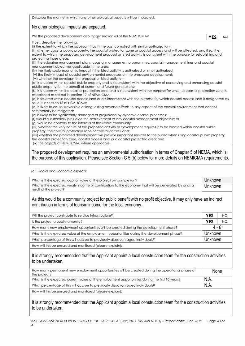
BASIC ASSESSMENT REPORT IN TERMS OF THE EIA REGULATIONS, 2014 (AS AMENDED) – Report date: June 2019 Page 40 of
84
Describe the manner in which any other biological aspects will be impacted:
No other biological impacts are expected.
Will the proposed development also trigger section 63 of the NEM: ICMA? YES NO
If yes, describe the following:
(i) the extent to which the applicant has in the past complied with similar authorisations;
(ii) whether coastal public property, the coastal protection zone or coastal access land will be affected, and if so, the
extent to which the proposed development proposal or listed activity is consistent with the purpose for establishing and
protecting those areas;
(iii) the estuarine management plans, coastal management programmes, coastal management lines and coastal
management objectives applicable in the area;
(iv) the likely socio-economic impact if the listed activity is authorised or is not authorised;
(v) the likely impact of coastal environmental processes on the proposed development;
(vi) whether the development proposal or listed activity—
(a) is situated within coastal public property and is inconsistent with the objective of conserving and enhancing coastal
public property for the benefit of current and future generations;
(b) is situated within the coastal protection zone and is inconsistent with the purpose for which a coastal protection zone is
established as set out in section 17 of NEM: ICMA;
(c) is situated within coastal access land and is inconsistent with the purpose for which coastal access land is designated as
set out in section 18 of NEM: ICMA;
(d) is likely to cause irreversible or long-lasting adverse effects to any aspect of the coastal environment that cannot
satisfactorily be mitigated;
(e) is likely to be significantly damaged or prejudiced by dynamic coastal processes;
(f) would substantially prejudice the achievement of any coastal management objective; or
(g) would be contrary to the interests of the whole community;
(vii) whether the very nature of the proposed activity or development requires it to be located within coastal public
property, the coastal protection zone or coastal access land;
(viii) whether the proposed development will provide important services to the public when using coastal public property,
the coastal protection zone, coastal access land or a coastal protected area; and
(ix) the objects of NEM: ICMA, where applicable.
The proposed development requires an environmental authorisation in terms of Chapter 5 of NEMA, which is the purpose of this application. Please see Section G 5 (b) below for more details on NEMICMA requirements.
(c) Social and Economic aspects:
What is the expected capital value of the project on completion? Unknown What is the expected yearly income or contribution to the economy that will be generated by or as a
result of the project? Unknown
As this would be a community project for public benefit with no profit objective, it may only have an indirect contribution in terms of tourism income for the local economy.
Will the project contribute to service infrastructure? YES NO
Is the project a public amenity? YES NO
How many new employment opportunities will be created during the development phase? 4 - 6
What is the expected value of the employment opportunities during the development phase? Unknown What percentage of this will accrue to previously disadvantaged individuals? Unknown How will this be ensured and monitored (please explain):
It is strongly recommended that the Applicant appoint a local construction team for the construction activities to be undertaken.
How many permanent new employment opportunities will be created during the operational phase of
the project? None
What is the expected current value of the employment opportunities during the first 10 years? N.A. What percentage of this will accrue to previously disadvantaged individuals? N.A. How will this be ensured and monitored (please explain):
It is strongly recommended that the Applicant appoint a local construction team for the construction activities to be undertaken.

BASIC ASSESSMENT REPORT IN TERMS OF THE EIA REGULATIONS, 2014 (AS AMENDED) – Report date: June 2019 Page 41 of
84
Any other information related to the manner in which the socio-economic aspects will be impacted:
None.
(d) Heritage and Cultural aspects:
See Section G3 below, as well as comment from Heritage Western Cape, Appendix E1.
2. WASTE AND EMISSIONS
(a) Waste (including effluent) management
Will the development proposal produce waste (including rubble) during the development phase? YES NO
If yes, indicate the types of waste (actual type of waste, e.g. oil, and whether hazardous or not) and
estimated quantity per type? 10 m3
The construction phase will generate solid waste: rubble and construction waste and possibly litter. No hazardous waste will be generated during the construction phase although the use of concrete in the stream channel poses a known risk of water quality impairment. Cement is a listed water contaminant in the legislation of several countries. Uncured concrete in contact with freshwater results in a marked and toxic increase in pH (highly alkaline conditions). This is toxic for most aquatic organisms and the risk is greatest when washdowns and slurries enter the water. Temporallysustained toxicity also maintains whilst concrete cures underwater. Additionally, cement may contain toxic heavy metals, create a blanket over river sediments and increase the turbidity of watercourses. The impacts of cementrich runoff/spills can be mitigated through comprehensive containment of the working area and the pumping of the contaminated water to a soak-away, grassed area or to be tankered off-site. The location of the stream in relation to the sea and the diluting factor during a relatively short construction time, however, will result in negligible impact.
A zero waste strategy will be aspired to. Construction waste will either be recycled, reused or crushed on site and reused as building material. Unfortunately it is inevitable that this activity will still generate a certain amount of unusable and unwanted waste that is good only for disposal by landfill, but these quantities will be minimal. Construction workers will also generate small volumes of general domestic waste (non-hazardous). Bins will be provided by the contractor for construction phase waste management and specifications and servicing of bins are to be managed in accordance with Environmental Management Programme (EMPr).
Will the development proposal produce waste during its operational phase? YES NO
If yes, indicate the types of waste (actual type of waste, e.g. oil, and whether hazardous or not) and
estimated quantity per type? m3
The only possible waste associated with the proposed development would be from litter by the public. Awareness signage will be erected in order to minimise littering
Will the development proposal require waste to be treated / disposed of on site? YES NO
If yes, indicate the types of waste (actual type of waste, e.g. oil, and whether hazardous or not) and
estimated quantity per type per phase of the proposed development to be treated/disposed of? m3
Not applicable
If no, where and how will the waste be treated / disposed of? Please explain.
Indicate the types of waste (actual type of waste, e.g. oil, and whether hazardous or not) and estimated
quantity per type per phase of the proposed development to be treated/disposed of?
m3
The solid wastes generated during the construction phase will be disposed of at a recognized site. The Environmental Management Programme (EMPr) attached to this document, stipulates how solid waste must be handled during the construction phase.

BASIC ASSESSMENT REPORT IN TERMS OF THE EIA REGULATIONS, 2014 (AS AMENDED) – Report date: June 2019 Page 42 of
84
Has the municipality or relevant authority confirmed that sufficient capacity exists for treating / disposing
of the waste to be generated by the development proposal?
If yes, provide written confirmation from the municipality or relevant authority. Not applicable
Will the development proposal produce waste that will be treated and/or disposed of at another facility
other than into a municipal waste stream? YES NO
If yes, has this facility confirmed that sufficient capacity exists for treating / disposing of the waste to be
generated by the development proposal?
Provide written confirmation from the facility.
YES NO
Does the facility have an operating license? (If yes, please attach a copy of the licence.) YES NO
Facility name:
Contact person:
Cell: Postal address:
Telephone: Postal code:
Fax: E-mail:
Describe the measures that will be taken to reduce, reuse or recycle waste:
An integrated waste management approach will be utilised that is based on waste minimisation and incorporates reduction, recycling and re-use where appropriate. The impacts of cementrich runoff/spills can be mitigated through comprehensive containment of the working area and for contaminated water to be tankered off-site.
(b) Emissions into the atmosphere
Will the development proposal produce emissions that will be released into the atmosphere? YES NO
If yes, does this require approval in terms of relevant legislation? YES NO
If yes, what is the approximate volume(s) of emissions released into the atmosphere? m3
Describe the emissions in terms of type and concentration and how these will be avoided/managed/treated/mitigated:
Not applicable
3. WATER USE (a) Indicate the source(s) of water for the development proposal by highlighting the appropriate box(es).
Municipal Water board Groundwater River, Stream,
Dam or Lake Other
The activity will not use
water
Note: Provide proof of assurance of water supply (e.g. Letter of confirmation from the municipality / water user associations,
yield of borehole)
(b) If water is to be extracted from a groundwater source, river, stream, dam, lake or any other
natural feature, please indicate the volume that will be extracted per month: N.A. m3
(c) Does the development proposal require a water use permit / license from DWS? YES NO
If yes, please submit the necessary application to the DWS and attach proof thereof to this application as an Appendix.
A General Authorisation may be required from the Department of Water and Sanitation, but it is possible that the Department will waive the need for it due to a fairly low risk to the identified watercourses. This is currently being investigated by a Freshwater Ecologist.
(d) Describe the measures that will be taken to reduce water demand, and measures to reuse or recycle water:
Not applicable

BASIC ASSESSMENT REPORT IN TERMS OF THE EIA REGULATIONS, 2014 (AS AMENDED) – Report date: June 2019 Page 43 of
84
4. POWER SUPPLY
(a) Describe the source of power e.g. municipality / Eskom / renewable energy source.
No electricity is necessary for this project.
(b) If power supply is not available, where will power be sourced?
Not applicable
3. ENERGY EFFICIENCY
(a) Describe the design measures, if any, that have been taken to ensure that the development proposal will be energy
efficient:
Not applicable
(b) Describe how alternative energy sources have been taken into account or been built into the design of the project, if
any:
Not applicable
4. TRANSPORT, TRAFFIC AND ACCESS
Describe the impacts in terms of transport, traffic and access.
The improved formalised pathway will enhance accessibility for pedestrians, improve safety and allow better control over impacts such as littering.
5. NUISANCE FACTOR (NOISE, ODOUR, etc.)
Describe the potential nuisance factor or impacts in terms of noise and odours.
It is unlikely that noise will be a significant nuisance. The site is located along the seashore, which creates natural white noise to soften any construction noise. Any noise emanating from construction equipment and activities during the construction phase will be temporary in nature. Furthermore, by restriction of construction activities to normal working hours (and taking tidal influence into account), this impact will be mitigated.
Note: Include impacts that the surrounding environment will have on the proposed development.

BASIC ASSESSMENT REPORT IN TERMS OF THE EIA REGULATIONS, 2014 (AS AMENDED) – Report date: June 2019 Page 44 of
84
6. OTHER
PLANNING, DESIGN & CONSTRUCTION PHASE IMPACTS Introduction of concrete into the natural environment – Geographical and Physical Impact The establishment of a structure where there was none before is an impact on the geographical environment as there would be a structure where there was none before. This would be a permanent impact, but would become part of the landscape over time. Pollution as a result of introduction of concrete into the natural environment – Geographical and Physical Impact Indirect impacts that may occur is pollution due to spillage of cement or concrete during casting, but any spillage not cleaned up would be of little quantity and dispersed into the ocean, thus temporary in nature. Destruction of vegetation Depending on the route followed by the HWM, it is very likely that some vegetation would need to be removed, but may only affect specific areas on the site where vegetation grows over the footprint of the path. The impact would be of low significance due to the sparse occurrence of vegetation below the HWM. Disturbance to the local aquatic and marine ecology – Biological Impact Earthworks and construction activities may have a temporary impact on the local aquatic ecology of the stream and wetland as identified by the freshwater ecologist. Such impacts would however be insignificant in the context of the ocean. Pollution through litter and building rubble It is probable that even with mitigation in place, littering could occur or building rubble could be left on site due to neglect by construction workers, but will likely only affect certain areas on the site. Increase in construction employment opportunities It is very likely that the proposed development will create construction employment opportunities. Visual intrusion of construction activities The presence of construction vehicles is unlikely due to the topography of the area and it is expected to mostly use manual labour, which will not result in significant visual intrusion. Destruction of archaeological resources Some archaeological resources (scatter of shells and quartzite flakes at historical steps) have been identified on certain areas of the site. These may have to be removed if the path is completely reconstructed in this area, but it may be possible to retain it here as is. OPERATIONAL PHASE IMPACTS Pollution through litter It is possible that even with mitigation in place, pollution could occur due to neglect or ignorance of path users. Litter would also be washed up from the sea. Improvement of access to coastal resources (tourism) The proposed path would connect two sections of a well-known tourist attraction, thus enhancing the current 12km Cliff Path and providing formalised access to a part of the coastline where it was previously not easy to do so.

BASIC ASSESSMENT REPORT IN TERMS OF THE EIA REGULATIONS, 2014 (AS AMENDED) – Report date: June 2019 Page 45 of
84
Increased safety for the public The formalisation of the connection path through concrete structures would provide safer pedestrian access during low tide. Appropriate signage would be required to create awareness of less safe conditions during high tide, as the path would be situated just below the HWM. Currently there is no indication of access conditions. Improved security and privacy (for neighbouring private property) Formal demarcation of the path would reduce incidences of trespassing on private property by criminal elements as there would be more movement of people along the path resulting in less opportunity for unauthorised access to private property. Improved privacy (for neigbouring private property) Formal demarcation of the path would reduce incidences of accidental entry on private property and limit pedestrians to a dedicated path. Visual impact of the development The visual impact will be highly localised. Due to its location below the HWM and limited visibility from surrounding areas, it will not have significant impact. it is also expected to reduce over time as the feature will become part of the landscape in the context of the existing Cliff Path. Employment creation The operational phase of the pathway, with associated awareness, clean-up and maintenance activities may create some opportunities, although it is likely that current functions would be utilized. If the NO-GO OPTION is to be implemented:
If no action is taken to improve the informal path and public access, safety of path users may be compromised.
Since there is no formal demarcation of the path, privacy of properties along this section of the coast may also be compromised.
The enhancement of tourism opportunities may not be realised.
There would be no new construction employment opportunities, resulting in no positive impact on the socio-economic aspects of the community.

BASIC ASSESSMENT REPORT IN TERMS OF THE EIA REGULATIONS, 2014 (AS AMENDED) – Report date: June 2019 Page 46 of
84

BASIC ASSESSMENT REPORT IN TERMS OF THE EIA REGULATIONS, 2014 (AS AMENDED) – Report date: June 2019 Page 47 of
84
SECTION G: IMPACT ASSESSMENT, IMPACT AVOIDANCE, MANAGEMENT,
MITIGATION AND MONITORING MEASURES
1. METHODOLOGY USED IN DETERMINING AND RANKING ENVIRONMENTAL IMPACTS AND RISKS
ASSOCIATED WITH THE ALTERNATIVES
(a) Describe the methodology used in determining and ranking the nature, significance consequences, extent, duration
and probability of potential environmental impacts and risks associated with the proposed development and
alternatives.
Due to the difficulty involved in attaching values to potential impacts, the risks of the potential impacts were determined according to certain criteria for determining risk ratings, namely Significance, Extent, Duration, Intensity and Probability of the impacts to an affected party or the affected environment. 1. Significance Assessment Significance rating of the associated impacts embraces the notion of extent and magnitude. The means of arriving at a Significance Rating is explained in Table 1 below: Table 1: Description of the Significance Rating scale
Significance Assessment
Standard Impact Assessment Methodology in order to compare a range of impacts.
Rating Significance Description Effect on decision making
1 Very low / Negligible
The impact is negligible within the bounds of impacts which could occur. In the case of adverse impacts, almost no mitigation and/or remedial activity are needed, and any minor steps which might be needed are easy, cheap, and simple. In the case of beneficial impacts, alternative means are almost all likely to be better, in one or a number of ways, than this means of achieving the benefit.
Will not have an influence on the decision to proceed with the proposed project, provided that the recommended mitigation measures to mitigate impacts are implemented. Will not have an influence on the decision to proceed with the proposed project, provided that the recommended mitigation measures to mitigate impacts are implemented.
2 Low
The impact is low where the impact affects the environment in such a way that natural, cultural and social functions and processes are minimally affected. In the case of adverse impacts, mitigation and/or remedial activity is either easily achieved or little will be required. In the case of beneficial impacts, alternative means for achieving this benefit are likely to be easier, cheaper and more effective.
3 Medium
Impact is real but not substantial in relation to other impacts. In the case of adverse impacts, mitigation and/or remedial activity are both feasible and fairly easily possible. In the case of beneficial impacts, other means of achieving this benefit are about equal in time, cost and effort.
Should influence the decision to proceed with the proposed project, provided that recommended measures to mitigate impacts are implemented.
4 High Impact is of substantial order within the bounds of impacts, which could occur. In the case of adverse impacts, mitigation and/or
Would strongly influence the decision to proceed with the

BASIC ASSESSMENT REPORT IN TERMS OF THE EIA REGULATIONS, 2014 (AS AMENDED) – Report date: June 2019 Page 48 of
84
remedial activity is feasible but difficult, expensive, time-consuming or some combination of these. In the case of beneficial impacts, other means of achieving this benefit are feasible but they are more difficult, expensive, time-consuming or some combination of these.
proposed project. Would strongly influence the decision to proceed with the proposed project.
5 Very-high
The impact on natural, cultural or social functions and processes are altered to the extent that it will temporarily or permanently cease; and valued, important, sensitive or vulnerable systems or communities are substantially affected. In the case of adverse impacts: there is no possible mitigation and/or remedial activity which could offset the impact. In the case of beneficial impacts, there is no real alternative to achieving this benefit.
2. Extent scale The Extent scale refers to the extent of the impact to be felt at the regional, local or site specific scale. The extent scale is explained in more detail in Table 2 below: Table 2: Description of the Spatial scale
Rating Description
1 Site specific The impact will affect only the specific site
2 Local The impact will affect as far as a 1 - 2 km radius area
3 Regional The impact will affect more than a 2 km radius area
3. Duration scale This explains the duration and persistence of an impact on affected parties or the environment. The duration scale is rated according to criteria set out in Table 3 below: Table 3: Description of the Duration scale
Rating Description
1 Construction period / Short term
The impact will be limited to the construction phase (up to 18 months).
2 Medium term The impact will persist for up to 5 years.
3 Permanent The impact will be permanent.
4. Intensity scale This explains the degree to which natural or social functions are altered, see Table 4 below: Table 4: Description of the Intensity scale
Rating Description
1 Low Natural or social functions are negligibly altered or even unaltered.
2 Medium Natural or social functions are slightly altered.
3 High Natural or social functions are severable or notably altered.
5. Probability scale This explains the likelihood of an impact occurring as described in Table 5 below:

BASIC ASSESSMENT REPORT IN TERMS OF THE EIA REGULATIONS, 2014 (AS AMENDED) – Report date: June 2019 Page 49 of
84
Table 5: Description of the Probability scale
Rating Description
1 Highly improbable The consultant believes that it is not going to happen
2 Unlikely Less than 40% chance
3 Probable 40% - 70% sure
4 Very likely 70% - 90% sure
5 Definite More than 90% certain that it is going to happen
QUANTITIVE DESCRIPTION OF IMPACTS To allow for impacts to be described in a quantitative manner, a rating scale of between 1 and 3 was used for each of the assessment criteria. Thus the total value of the impact is described as the function of significance, extent, duration, intensity and probability scale as described below: (Significance + Spatial + Duration + Intensity) Probability Impact Risk = X
4 5 An example of how this rating scale is applied is shown below in Table 6: Table 6: Example of rating scale
Impact Nature of impact
Criteria Rating
Spatial Duration Intensity Probability
Noise impact Low 2
Local 2
Construction 1
Low 1
Unlikely 2
0,6
Note: The significance, spatial, duration and intensity scales are added to give a total of 6, that is divided by 4 to give a criteria rating of 1,5. The probability (2) is divided by 5 to give a probability rating of 0,4. The criteria rating of 1,5 is then multiplied by the probability rating (0,4) to give the final rating of 0,6. The impact risk is classified according to 5 impact ratings as described in Table 7 below: Table 7: Impact risk rating
Rating Description
0.1 – 0.7 Very Low / Insignificant
0.8 – 1.4 Low
1.5 – 2.1 Medium
2.2 – 2.8 High
2.9 – 3.5 Very High
Therefore with reference to the example used for noise impact above, an impact rating of 0.6 will be considered to be a Very Low impact.

BASIC ASSESSMENT REPORT IN TERMS OF THE EIA REGULATIONS, 2014 (AS AMENDED) – Report date: June 2019 Page 50 of 84
IMPACT ASSESSMENT AND RISK RATING OF THE PROPOSED CONNECTION PATH ALONG POOLE’S BAY, HERMANUS.
Table 8: Impact Assessment Ratings for Construction Construction
Aspect: Impact: Criteria
Rating Significance Spatial Duration Intensity Probability
Geographical / physical
Structure in the landscape
Other means of realising this benefit may likely be cheaper to
achieve
Site specific – limited to footprint of the path, less
than 1km long area
The proposed path is intended to be a permanent feature
Negligible alteration of natural functions
Definite if the path is built 1.75
2 1 3 1 3 Med+
Geographical / physical
Indirect: spillage of concrete / pollution
Impact not substantial, remediation fairly easy to achieve
Site specific – limited to areas where concrete is to be cast in place, less than
1km long area
Spillages would occur only during construction, possibly if needed during maintenance
Negligible alteration of natural functions, any spillage not cleaned up would likely be
dispersed of in the sea
Probable
0.9
3 1 1 1 3 Low-
Biological Disruption of
aquatic / marine ecology
The impact is negligible within the bounds of impacts which it could
occur as watercourses are on private property above the HWM, which would be a no-go area. the
stream which needs to be crossed, is a narrow trickle over
the beach into the sea with limited function
The impact may affect only the specific identified
areas on site
Provided the flow of water is not interrupted permanently, the potential impact would be minimised. This impact may only occur during the time when the infrastructure is
being built in this particular area where the watercourses
occur
Provided the flow of water is not
interrupted (which can be achieved through
mitigation), the potential impact would
be minimised, thus negligible alteration of
natural functions
Although it will be of short term (even temporary), the
stream flow would have to be interrupted
if slabs / stepping stones are installed at
this point
1
1 1 1 1 5 Low-
Biological
Destruction of vegetation
The impact is negligible within the bounds of which it could occur
due to the sparse occurrence of vegetation on the path footprint.
Most vegetation is located on neighbouring private property, which would be a no-go area.
The impact may affect only specific areas on site
where vegetation does grow over the proposed
path footprint.
Vegetation would not grow back where the path is
constructed, so the impact would be permanent within the
footprint of the path
Negligible alteration of natural functions, as there is very limited
vegetation below the HWM of the sea.
Depending on the route followed by the HWM, it is very likely that some vegetation
would need to be removed.
1.2
1 1 3 1 4 Low-
Waste Pollution - litter and
building rubble
Impact is low and can be easily mitigated
The impact may affect only specific areas on
site
May occur only during construction
Negligible alteration of natural functions
It is probable that even with mitigation in place, it could occur
due to neglect by construction workers
0.75
2 1 1 1 3 Low-

BASIC ASSESSMENT REPORT IN TERMS OF THE EIA REGULATIONS, 2014 (AS AMENDED) – Report date: June 2019 Page 51 of 84
Noise Nuisance of
construction noise
Impact is very low due to natural noise mitigation by wave action
The impact may affect only specific areas on
site
Short-term, only during construction
Negligible alteration of social functions
Although of very low significance, it is probable that the
impact would occur
0.6
1 1 1 1 3 very low-
Visual Visual intrusion of
activities
Impact would be low, as most of the construction area would not be
visible to the public and be limited to some private properties abutting
the HWM
The impact may affect only specific areas on
site
Short-term, only during construction
Negligible alteration of social functions
Very likely that construction activities would visually intrude
according to some perceptions, but due
to the short term nature may not be
regarded as an impact by others
1
2 1 1 1 4 low-
Socio-economic Destruction of archaeological
resources
Should identified resources need to be removed, the impact would be
real but not substantial in relation to other impacts, little mitigation would
be required
The impact may affect only one specific area on
site
Permanent impact if it were to be removed
Negligible alteration of social functions
It is probable that the identified resources would need to be
removed, but unlikely as it forms part of a
section of the informal path that could still be
utilised as such (mitigation)
0.8
3 1 3 1 2 low-
Socio-economic Employment
creation
Other means of achieving this are about equal in time, cost, and effort
Employment would be sourced from more than
2km away, thus be a regional impact
Opportunities would be limited to construction phase
Negligible alteration of social functions due to limited opportunities
as the project is not of large scale
Construction workers would definitely be
required, but there is a chance that it would
not require new appointments and that local contractors with existing labour would
be utilised
1.6
3 3 1 1 4 med+

BASIC ASSESSMENT REPORT IN TERMS OF THE EIA REGULATIONS, 2014 (AS AMENDED) – Report date: June 2019 Page 52 of 84
Table 9: Impact Assessment Ratings for Operation Operation
Aspect: Impact: Criteria
Rating Significance Spatial Duration Intensity Probability
Waste Pollution - litter
Impact is low and can be easily mitigated
The impact may affect only specific areas on
site
Would occur on an ongoing basis (from sea)
Negligible alteration of natural functions
It is probable that even with mitigation in place, it could occur
due to neglect or ignorance of path users. Litter would also be washed up
from the sea
1.05
2 1 3 1 3 low-
Socio-economic
Improvement of access to coastal
resources (tourism)
This is a positive impact to which there is no real alternative to
achieving this benefit
The proposed connection path would be almost 1km long, but would enhance
the overall Cliff path which is over 12km long
The proposed path would be permanent, thus having
permanent impact on access to the coast
Social functions (access) would be
notably altered
It is very likely that the proposed path would have a notable impact 2.8
5 3 3 3 4 high+
Socio-economic Improvement of
safety (pedestrians)
This is a positive impact to which there is no real alternative to
achieving this benefit
The proposed connection path would be almost 1km
long, where there is currently no warning
regarding tide conditions / demarcation of a safe
path
The proposed path would be permanent, thus having
permanent impact on safety in this area of the coast line
Social functions (safety) would be notably altered, provided that mitigation is
implemented and adhered to
It is very likely that the proposed path would have a notable impact
2.4
5 2 3 2 4 high+
Socio-economic
Improvement of security
(neighbouring private property)
This is a positive impact to which there to which there may be
cheaper alternatives to achieving this benefit, although it would then be the responsibility of individual
property owners
This positive impact would occur along the
length of the connection path, which would be
almost 1km
This would be a permanent impact if associated with the
formalisation of the path
Social functions (security) would be
altered, albeit slightly
Although it cannot be guaranteed, it is
probable that security would be improved
1.35
2 2 3 2 3 low+

BASIC ASSESSMENT REPORT IN TERMS OF THE EIA REGULATIONS, 2014 (AS AMENDED) – Report date: June 2019 Page 53 of 84
Socio-economic
Improvement of privacy (reduced trespassing on neighbouring
private property)
This is a positive impact to which there to which there may be
cheaper alternatives to achieving this benefit, although it would then be the responsibility of individual
property owners
This positive impact would occur along the
length of the connection path, which would be
almost 1km
This would be a permanent impact if associated with the
formalisation of the path
Social functions (security) would be
altered, albeit slightly
Although it cannot be guaranteed, it is very likely that pedestrians would adhere to the
demarcated path and not wander onto
private property if the path is safer and
clearly demarcated
1.8
2 2 3 2 4 med+
Socio-economic Employment
creation
Other means of achieving this are about equal in time, cost and effort
Employment would be sourced from more than
2km away, thus be a regional impact
Opportunities would be limited to maintenance and litter clean
up
Negligible alteration of social functions due to limited opportunities
as the project is not of large scale
Unlikely that new opportunities would be created during
operational phase of the project
0.8
3 3 1 1 2 low+
Cultural
Improvement of the landscape and
natural features (the Cliff Path valued by the
local community for aesthetic significance)
There is no real alternative to achieving this benefit
As the entire Cliff path will be benefitted, the impact
will have an effect at regional scale
Once established, this will be a permanent impact
The social function of the path will be notably altered
If the path is constructed, this cultural resource
would very likely be improved.
2.4
5 3 3 3 4 high+

BASIC ASSESSMENT REPORT IN TERMS OF THE EIA REGULATIONS, 2014 (AS AMENDED) – Report date: June 2019 Page 54 of
84
(b) Please describe any gaps in knowledge.
Gaps in knowledge include:
Issues that may arise from the public participation process which have not yet been identified by the EAP.
Future changes in circumstances and legislation can also not be accounted for at this stage.
(c) Please describe the underlying assumptions.
Initial assumptions:
It is assumed that all information on which this report is based is truthful and correct.
All the relevant design and mitigation measures specified in this report will be implemented in order to achieve an acceptable level of impact and to ensure minimal impact on the surrounding environment.
It has been assumed that the description of the proposed project, provided by the applicant, is accurate.
It is assumed that the Public Participation Process undertaken as part of the Basic Assessment Process will be sufficient and adequate. Every effort will be made to inform all potential stakeholders of the proposed development (notification through letters, advertisements, site notices). The demography, language preferences or social standing of some potential I&AP’s cannot always be catered for despite best efforts.
(d) Please describe the uncertainties.
The impacts have been identified and assessed to the EAP’s best ability. Any other impacts not identified are currently unknown. The extent to which organs of state can intervene to provide safe access to the coastal public property is uncertain and may influence the alternatives proposed in this phase of the application. The high water mark has been surveyed as per maps in Appendix B, but would need to be confirmed by the Land Surveyor General.
(e) Describe adequacy of the assessment methods used.
During the Basic Assessment process a range of potential impacts are identified, and assessed/evaluated against certain criteria. Impacts are identified through various ways which include:
Site visits by the EAP and specialists to determine the nature and sensitivity of the site and to gain an understanding of the surrounding environment.
Consultation with the Applicant and key stakeholders to provide an understanding of the need for the proposed activity.
Specialist input was obtained: - Freshwater Ecology Study - Heritage Notice of Intent to Develop
Consideration of the applicable legislation, guidelines and policies (see complete list in Section B11 of this Report).
In order to ensure uniformity, standard impact assessment methodology has been utilised so that a wide range of impacts can be compared.
The assessment methods used are anticipated to be adequate for the nature of the application and site.
Given the above, sufficient information has been compiled to be adequate for the nature of the application and site.
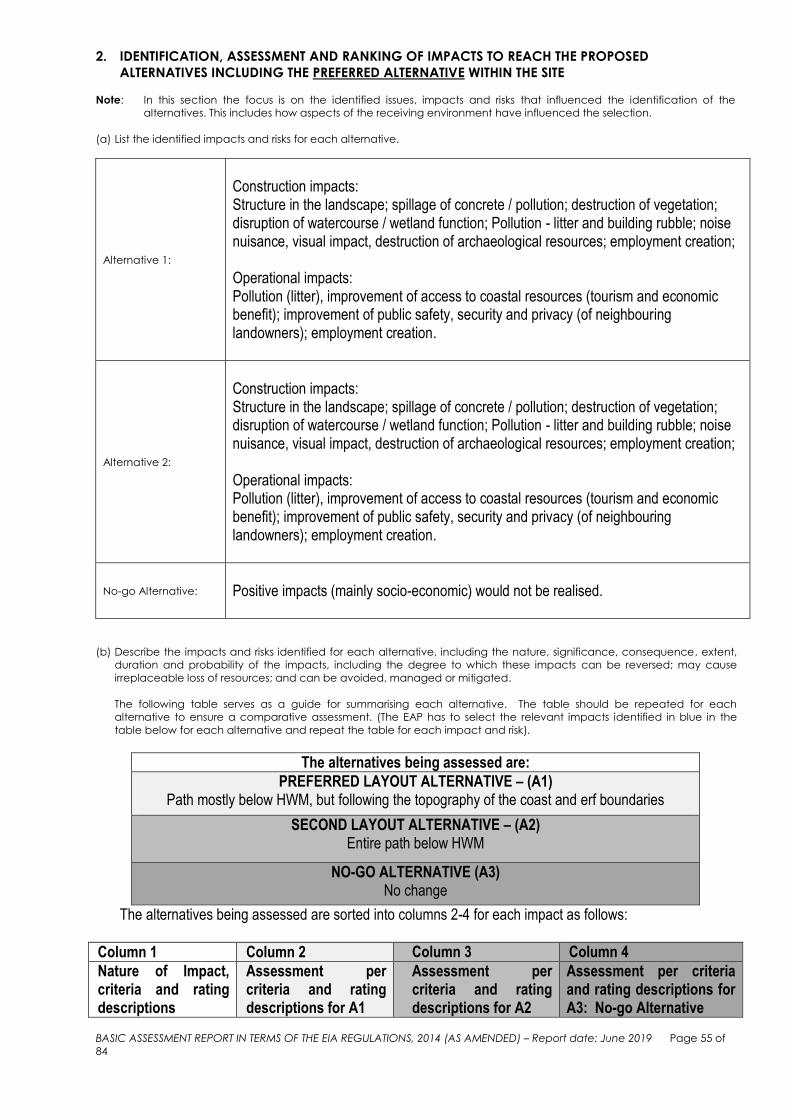
BASIC ASSESSMENT REPORT IN TERMS OF THE EIA REGULATIONS, 2014 (AS AMENDED) – Report date: June 2019 Page 55 of
84
2. IDENTIFICATION, ASSESSMENT AND RANKING OF IMPACTS TO REACH THE PROPOSED
ALTERNATIVES INCLUDING THE PREFERRED ALTERNATIVE WITHIN THE SITE
Note: In this section the focus is on the identified issues, impacts and risks that influenced the identification of the
alternatives. This includes how aspects of the receiving environment have influenced the selection.
(a) List the identified impacts and risks for each alternative.
Alternative 1:
Construction impacts: Structure in the landscape; spillage of concrete / pollution; destruction of vegetation; disruption of watercourse / wetland function; Pollution - litter and building rubble; noise nuisance, visual impact, destruction of archaeological resources; employment creation; Operational impacts: Pollution (litter), improvement of access to coastal resources (tourism and economic benefit); improvement of public safety, security and privacy (of neighbouring landowners); employment creation.
Alternative 2:
Construction impacts: Structure in the landscape; spillage of concrete / pollution; destruction of vegetation; disruption of watercourse / wetland function; Pollution - litter and building rubble; noise nuisance, visual impact, destruction of archaeological resources; employment creation; Operational impacts: Pollution (litter), improvement of access to coastal resources (tourism and economic benefit); improvement of public safety, security and privacy (of neighbouring landowners); employment creation.
No-go Alternative: Positive impacts (mainly socio-economic) would not be realised.
(b) Describe the impacts and risks identified for each alternative, including the nature, significance, consequence, extent,
duration and probability of the impacts, including the degree to which these impacts can be reversed; may cause
irreplaceable loss of resources; and can be avoided, managed or mitigated.
The following table serves as a guide for summarising each alternative. The table should be repeated for each
alternative to ensure a comparative assessment. (The EAP has to select the relevant impacts identified in blue in the
table below for each alternative and repeat the table for each impact and risk).
The alternatives being assessed are:
PREFERRED LAYOUT ALTERNATIVE – (A1) Path mostly below HWM, but following the topography of the coast and erf boundaries
SECOND LAYOUT ALTERNATIVE – (A2) Entire path below HWM
NO-GO ALTERNATIVE (A3) No change
The alternatives being assessed are sorted into columns 2-4 for each impact as follows:
Column 1 Column 2 Column 3 Column 4
Nature of Impact, criteria and rating descriptions
Assessment per criteria and rating descriptions for A1
Assessment per criteria and rating descriptions for A2
Assessment per criteria and rating descriptions for A3: No-go Alternative

BASIC ASSESSMENT REPORT IN TERMS OF THE EIA REGULATIONS, 2014 (AS AMENDED) – Report date: June 2019 Page 56 of 84
(a) Impacts that may result from the planning, design and construction phase (briefly describe and compare the potential impacts (as appropriate), significance rating of impacts,
proposed mitigation and significance rating of impacts after mitigation that are likely to occur as a result of the planning, design and construction phase.
CRITERIA A1 A2 A3 Potential impacts on the geographical and physical
aspects: Structure in the landscape
Nature of impact: Positive (considering positive socio-cultural impacts)
Positive (considering positive socio-cultural impacts)
Neutral -No impact
Extent and duration of impact: Local, permanent Local, permanent Consequence of impact or risk: Acceptable Low risk Acceptable Low risk Probability of occurrence: Definite if approved Definite if approved
Degree to which the impact can be reversed: Medium, not impossible, but may be difficult
Medium, not impossible, but may be difficult
Degree to which the impact may cause
irreplaceable loss of resources: Low Low
Indirect impacts:
Pollution as a result of
concrete spillage during construction
building rubble
litter from workers (negative impacts of low significance)
Pollution as a result of
concrete spillage during construction
building rubble
litter from workers (negative impacts of low significance)
Cumulative impact prior to mitigation: None None Significance rating of impact prior to mitigation
(Low, Medium, Medium-High, High, or Very-High) Low Low
Degree to which the impact can be avoided: Not applicable Not applicable Degree to which the impact can be managed: High High Degree to which the impact can be mitigated: High High
Proposed mitigation:
The appearance to match the existing Cliff path For indirect impacts, implement waste management measures
The appearance to match the existing Cliff path For indirect impacts, implement waste management measures
Residual impacts: Structure in the landscape Structure in the landscape
Cumulative impact post mitigation: Positive – overall enhancement of 13km existing Cliff Path
Positive – overall enhancement of 13km existing Cliff Path
Significance rating of impact after mitigation
(Low, Medium, Medium-High, High, or Very-High) Low Low

BASIC ASSESSMENT REPORT IN TERMS OF THE EIA REGULATIONS, 2014 (AS AMENDED) – Report date: June 2019 Page 57 of 84
CRITERIA A1 A2 A3
Potential impact on biological aspects: Destruction of vegetation
Nature of impact: Negative Negative Neutral - No impact Extent and duration of impact: Site specific, permanent within footprint Site specific, permanent within footprint Consequence of impact or risk: Acceptable low risk Acceptable low risk Probability of occurrence: Very likely Very likely
Degree to which the impact can be reversed: Medium –where rehabilitation is possible next to the path footprint
Medium –where rehabilitation is possible next to the path footprint
Degree to which the impact may cause
irreplaceable loss of resources: Low Low
Indirect Impacts: None – insignificant scale None - insignificant scale
Cumulative impact prior to mitigation: Further reduction of Critically endangered vegetation type (insignificant quantity)
Unlikely reduction of Critically endangered vegetation type (insignificant quantity)
Significance rating of impact prior to mitigation
(Low, Medium, Medium-High, High, or Very-High) Low Low
Degree to which the impact can be avoided: High High Degree to which the impact can be managed: High High Degree to which the impact can be mitigated: Medium Medium
Proposed mitigation:
Rehabilitation where possible below the HWM, private property above the HWM where vegetation occurs to be avoided as no-go area, but to be rehabilitated if accidentally disturbed.
Rehabilitation where possible below the HWM, private property above the HWM where vegetation occurs to be avoided as no-go area, but to be rehabilitated if accidentally disturbed
Residual impacts:
Due to the sparse occurrence of vegetation below the HWM within the path footprint, it is unlikely that there would be residual impacts and may be limited to areas where the path would be located above the HWM (e.g. connection points to current path)
Due to the sparse occurrence of vegetation below the HWM where the path footprint would be located, it is unlikely that there would be residual impacts and may be limited to areas where the path would be located above the HWM (e.g. connection points to current path)
Cumulative impact post mitigation:
Local improvement of vegetation type through rehabilitation and reduced trampling
Local improvement of vegetation type through reduced trampling
Significance rating of impact after mitigation
(Low, Medium, Medium-High, High, or Very-High) Low Low

BASIC ASSESSMENT REPORT IN TERMS OF THE EIA REGULATIONS, 2014 (AS AMENDED) – Report date: June 2019 Page 58 of 84
CRITERIA A1 A2 A3
Potential impact on biological aspects: Disruption of marine / aquatic ecology
Nature of impact: Negative Negative Neutral - No impact Extent and duration of impact: Site specific, temporary Site specific, temporary Consequence of impact or risk: Acceptable low risk Acceptable low risk
Probability of occurrence:
Definitely, streamflow would have to be interrupted when constructing through the area in vicinity of the stream
Definitely, streamflow would have to be interrupted when constructing through the area in vicinity of the stream
Degree to which the impact can be reversed: High, as disruption would be temporary High, as disruption would be temporary Degree to which the impact may cause
irreplaceable loss of resources: Negligible Negligible
Indirect Impacts: None - insignificant scale None - insignificant scale Cumulative impact prior to mitigation: Not applicable Not applicable
Significance rating of impact prior to mitigation
(Low, Medium, Medium-High, High, or Very-High) Low Low
Degree to which the impact can be avoided: High High Degree to which the impact can be managed: High High Degree to which the impact can be mitigated: Medium Medium
Proposed mitigation:
Cementrich runoff/spills that may disrupt ecology can be mitigated through comprehensive containment of the working area and removal off-site.
Cementrich runoff/spills that may disrupt ecology can be mitigated through comprehensive containment of the working area and removal off-site.
Residual impacts: None expected None expected
Cumulative impact post mitigation:
The location of the stream in relation to the sea and the diluting factor during a relatively short construction time would result in negligible impact.
The location of the stream in relation to the sea and the diluting factor during a relatively short construction time would result in negligible impact.
Significance rating of impact after mitigation
(Low, Medium, Medium-High, High, or Very-High) Negligible Negligible

BASIC ASSESSMENT REPORT IN TERMS OF THE EIA REGULATIONS, 2014 (AS AMENDED) – Report date: June 2019 Page 59 of 84
CRITERIA A1 A2 A3
Potential impacts on socio-economic aspects: Construction employment opportunities.
Nature of impact: Positive Positive Neutral Extent and duration of impact: Local extent and Temporary in nature Local extent and Temporary in nature If no development takes place, no
new employment opportunities can be created.
Consequence of impact or risk: Increase in employment opportunities. Increase in employment opportunities.
Probability of occurrence: Very likely as there is a 70% – 90% chance that construction will take place.
Very likely as there is a 70% – 90% chance that construction will take place.
Degree to which the impact can be reversed: Positive impact – no need to reverse Positive impact – no need to reverse Degree to which the impact may cause
irreplaceable loss of resources: Not applicable Not applicable
Indirect impacts: Community upliftment and reduced poverty, albeit on very small scale.
Community upliftment and reduced poverty, albeit on very small scale.
Cumulative impact prior to mitigation:
Many local community members are without work and do not have the opportunity to develop and learn new skills.
Many local community members are without work and do not have the opportunity to develop and learn new skills.
Significance rating of impact prior to mitigation
(Low, Medium, Medium-High, High, or Very-High) Med - positive Med - positive
Degree to which the impact can be avoided: No avoidance needed. No avoidance needed. Degree to which the impact can be managed: High High Degree to which the impact can be mitigated: Low Low
Proposed mitigation:
As many as possible local community members should be employed. This will ensure that there is skills transfer for the benefit of possible future employment.
As many as possible local community members should be employed. This will ensure that there is skills transfer for the benefit of possible future employment.
Residual impacts: Skills investment. Skills investment
Cumulative impact post mitigation:
Temporary construction jobs are of great value. Not only will money be invested into the local community, but also new skills can be learnt and implemented elsewhere in the future. This will result in a positive socio-economic impact.
Temporary construction jobs are of great value. Not only will money be invested into the local community, but also new skills can be learnt and implemented elsewhere in the future. This will result in a positive socio-economic impact.
Significance rating of impact after mitigation
(Low, Medium, Medium-High, High, or Very-High) Med - positive Med - positive

BASIC ASSESSMENT REPORT IN TERMS OF THE EIA REGULATIONS, 2014 (AS AMENDED) – Report date: June 2019 Page 60 of 84
CRITERIA A1 A2 A3
Potential impacts on cultural-historical aspects: Destruction of archaeological resources – old steps on eastern side of proposed connection path
Nature of impact: Negative Negative Neutral - No impact
Extent and duration of impact: Site specific but permanent – only where the resource occurs
Site specific but permanent – only where the resource occurs
Consequence of impact or risk: The consequence would be of low significance
The consequence would be of low significance
Probability of occurrence: Permanent, if removed Permanent, if removed
Degree to which the impact can be reversed: The impact cannot be reversed if it occurred
The impact cannot be reversed if it occurred
Degree to which the impact may cause
irreplaceable loss of resources: High High
Indirect impacts: None identified None identified Cumulative impact prior to mitigation: Not applicable Not applicable Significance rating of impact prior to mitigation
(Low, Medium, Medium-High, High, or Very-High) Medium Medium
Degree to which the impact can be avoided: High High Degree to which the impact can be managed: High High Degree to which the impact can be mitigated: High High
Proposed mitigation:
Should identified resources need to be removed, the impact would be real but not substantial in relation to other impacts, little mitigation would be required. Mitigation would include incorporation of the existing steps into the proposed connection path.
Should identified resources need to be removed, the impact would be real but not substantial in relation to other impacts, little mitigation would be required. Mitigation would include incorporation of the existing steps into the proposed connection path.
Residual impacts: Removal of the steps would be a permanent impact.
Removal of the steps would be a permanent impact.
Cumulative impact post mitigation: Not applicable Not applicable Significance rating of impact after mitigation
(Low, Medium, Medium-High, High, or Very-High) Low Low
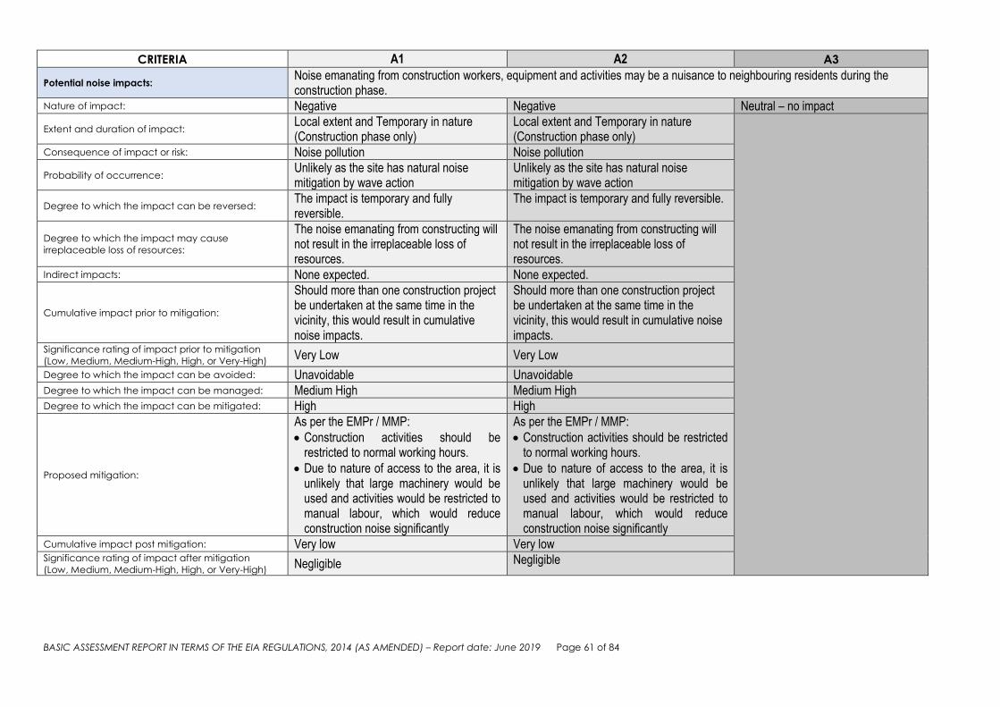
BASIC ASSESSMENT REPORT IN TERMS OF THE EIA REGULATIONS, 2014 (AS AMENDED) – Report date: June 2019 Page 61 of 84
CRITERIA A1 A2 A3
Potential noise impacts: Noise emanating from construction workers, equipment and activities may be a nuisance to neighbouring residents during the construction phase.
Nature of impact: Negative Negative Neutral – no impact
Extent and duration of impact: Local extent and Temporary in nature (Construction phase only)
Local extent and Temporary in nature (Construction phase only)
Consequence of impact or risk: Noise pollution Noise pollution
Probability of occurrence: Unlikely as the site has natural noise mitigation by wave action
Unlikely as the site has natural noise mitigation by wave action
Degree to which the impact can be reversed: The impact is temporary and fully reversible.
The impact is temporary and fully reversible.
Degree to which the impact may cause
irreplaceable loss of resources:
The noise emanating from constructing will not result in the irreplaceable loss of resources.
The noise emanating from constructing will not result in the irreplaceable loss of resources.
Indirect impacts: None expected. None expected.
Cumulative impact prior to mitigation:
Should more than one construction project be undertaken at the same time in the vicinity, this would result in cumulative noise impacts.
Should more than one construction project be undertaken at the same time in the vicinity, this would result in cumulative noise impacts.
Significance rating of impact prior to mitigation
(Low, Medium, Medium-High, High, or Very-High) Very Low Very Low
Degree to which the impact can be avoided: Unavoidable Unavoidable Degree to which the impact can be managed: Medium High Medium High Degree to which the impact can be mitigated: High High
Proposed mitigation:
As per the EMPr / MMP:
Construction activities should be restricted to normal working hours.
Due to nature of access to the area, it is unlikely that large machinery would be used and activities would be restricted to manual labour, which would reduce construction noise significantly
As per the EMPr / MMP:
Construction activities should be restricted to normal working hours.
Due to nature of access to the area, it is unlikely that large machinery would be used and activities would be restricted to manual labour, which would reduce construction noise significantly
Cumulative impact post mitigation: Very low Very low Significance rating of impact after mitigation
(Low, Medium, Medium-High, High, or Very-High) Negligible Negligible

BASIC ASSESSMENT REPORT IN TERMS OF THE EIA REGULATIONS, 2014 (AS AMENDED) – Report date: June 2019 Page 62 of 84
CRITERIA A1 A2 A3
Potential visual impacts: Visual intrusion of construction activities
Nature of impact: Negative Negative Neutral – no impact Extent and duration of impact: Site specific and temporary in nature Site specific and temporary in nature
Consequence of impact or risk:
Construction activities will have a temporary visual impact due to presence of workers, materials and equipment on site.
Construction activities will have a temporary visual impact due to presence of workers, materials and equipment on site.
Probability of occurrence: It is probable that this impact will occur at some stage of the development.
It is probable that this impact will occur at some stage of the development.
Degree to which the impact can be reversed: Completely reversible at the end of the construction phase.
Completely reversible at the end of the construction phase.
Degree to which the impact may cause
irreplaceable loss of resources:
This activity will not result in the irreplaceable loss of resources.
This activity will not result in the irreplaceable loss of resources.
Indirect impacts: Unsightly environment. Unsightly environment.
Cumulative impact prior to mitigation:
Visual intrusion will result from construction activities on site; however, visual intrusion will be limited to the construction phase.
Visual intrusion will result from construction activities on site, however, visual intrusion will be limited to the construction phase.
Significance rating of impact prior to mitigation
(Low, Medium, Medium-High, High, or Very-High) Low Low
Degree to which the impact can be avoided: Medium high Medium high Degree to which the impact can be managed: High High Degree to which the impact can be mitigated: The impact can be mitigated. The impact can be mitigated.
Proposed mitigation:
As the site is out of the public eye, visual intrusion is expected to be minimal. It can still be mitigated as per the EMPr / MMP:
Implement measures for visual screening where appropriate e.g. shade cloth and fencing to screen sites
Construction activities should be limited to “normal working hours”.
Implement litter control measures.
Ensure housekeeping at construction sites
As the site is out of the public eye, visual intrusion is expected to be minimal. It can still be mitigated as per the EMPr / MMP:
Implement measures for visual screening where appropriate e.g. use shade cloth in combination with fencing to screen sites
Construction activities should be limited to “normal working hours”.
Implement litter control measures.
Ensure housekeeping at construction sites
Residual impacts: None expected None expected
Cumulative impact post mitigation: Very low Very low
Significance rating of impact after mitigation
(Low, Medium, Medium-High, High, or Very-High) Negligible Negligible

BASIC ASSESSMENT REPORT IN TERMS OF THE EIA REGULATIONS, 2014 (AS AMENDED) – Report date: June 2019 Page 63 of 84
(b) Impacts that may result from the operational phase (briefly describe and compare the potential impacts (as appropriate), significance rating of impacts, proposed mitigation and
significance rating of impacts after mitigation that are likely to occur as a result of the operational phase.
CRITERIA A1 A2 A3 Potential impacts on the geographical and
physical aspects: Pollution - litter
Nature of impact: Negative Negative Negative
Extent and duration of impact:
The impact may affect only specific areas on site but would likely occur on an ongoing basis (from the sea)
The impact may affect only specific areas on site but would likely occur on an ongoing basis (from the sea)
The impact would occur, even if the development does not go ahead
Consequence of impact or risk: Management of the area would improve litter control
Management of the area would improve litter control
Probability of occurrence:
It is probable that even with mitigation in place, it could occur due to neglect or ignorance of path users. Litter would also be washed up from the sea
It is probable that even with mitigation in place, it could occur due to neglect or ignorance of path users. Litter would also be washed up from the sea
Degree to which the impact can be reversed: Low Low Indirect impacts: Entanglement of animals in litter Entanglement of animals in litter Degree to which the impact may cause
irreplaceable loss of resources: Low Low
Cumulative impact prior to mitigation:
Low – the formalisation of the path would make a negligible difference to littering already occurring in the area.
Low – the formalisation of the path would make a negligible difference to littering already occurring in the area.
Significance rating of impact prior to mitigation
(Low, Medium, Medium-High, High, or Very-High) Low Low
Degree to which the impact can be avoided: Low Low Degree to which the impact can be managed: High High Degree to which the impact can be mitigated: High High
Proposed mitigation: Provision of litter bins, regular clean ups, awareness signage
Provision of litter bins, regular clean ups, awareness signage
Residual impacts: None None
Cumulative impact post mitigation: Low Low
Significance rating of impact after mitigation
(Low, Medium, Medium-High, High, or Very-High) Low Low

BASIC ASSESSMENT REPORT IN TERMS OF THE EIA REGULATIONS, 2014 (AS AMENDED) – Report date: June 2019 Page 64 of 84
CRITERIA A1 A2 A3
Potential impacts on the socio-economic aspects: Improved access to coastal resources (for local community as well as tourism) through the formalisation of the path
Nature of impact: Positive Positive Indirectly Negative
Extent and duration of impact: Site specific and permanent (life time of path)
Site specific and permanent (life time of path)
No development would not result in improved safe accessibility for the public.
Consequence of impact or risk: This is a positive impact to which there is no real alternative to achieving this benefit
This is a positive impact to which there is no real alternative to achieving this benefit
Probability of occurrence: Very likely Very likely Degree to which the impact can be reversed: Positive impact – no need to reverse Positive impact – no need to reverse Degree to which the impact may cause
irreplaceable loss of resources: None None
Indirect impacts: Economic benefit for tourism Improved safety of pedestrians
Economic benefit for tourism Improved safety of pedestrians
Cumulative impact prior to mitigation:
Linking the existing Hermanus Cliff path, would add to its appeal to local as well as other users.
Linking the existing Hermanus Cliff path, would add to its appeal to local as well as other users.
Significance rating of impact prior to mitigation
(Low, Medium, Medium-High, High, or Very-High) High High
Degree to which the impact can be avoided: Positive – no avoidance needed. Positive – no avoidance needed. Degree to which the impact can be managed: Medium-high Medium-high
Degree to which the impact can be mitigated: The impact can be enhanced through constant maintenance of infrastructure
The impact can be enhanced through constant maintenance of infrastructure
Proposed mitigation:
Warnings regarding tide conditions / demarcation of a safe path Routine maintenance of the pathway and signage.
Warnings regarding tide conditions / demarcation of a safe path Routine maintenance of the pathway and signage.
Residual impacts: None applicable None applicable
Cumulative impact post mitigation:
The proposed connection path would be almost 1km long, but would enhance access to the overall Cliff path which is over 12km long. From a Health and Safety perspective, given the evident high energy of wave action in the area, this initiative is of considerable value to minimize risks to human life.
The proposed connection path would be almost 1km long, but would enhance access to the overall Cliff path which is over 12km long. From a Health and Safety perspective, given the evident high energy of wave action in the area, this initiative is of considerable value to minimize risks to human life.
Significance rating of impact after mitigation
(Low, Medium, Medium-High, High, or Very-High) High –very high High –very high

BASIC ASSESSMENT REPORT IN TERMS OF THE EIA REGULATIONS, 2014 (AS AMENDED) – Report date: June 2019 Page 65 of 84
CRITERIA A1 A2 A3
Potential impacts on the socio-economic aspects: Increased security and privacy for the local land owners through the formalisation of the path
Nature of impact: Positive Positive Neutral Extent and duration of impact: Site specific and permanent Site specific and permanent No change to current situation
Consequence of impact or risk:
This is a positive impact to which there to which there may be cheaper alternatives to achieving this benefit, although it would then be the responsibility of individual property owners
This is a positive impact to which there to which there may be cheaper alternatives to achieving this benefit, although it would then be the responsibility of individual property owners
Probability of occurrence:
Very likely - Although it cannot be guaranteed, it is very likely that pedestrians would adhere to the demarcated path and not wander onto private property if the path is safer and clearly demarcated
Very likely - Although it cannot be guaranteed, it is very likely that pedestrians would adhere to the demarcated path and not wander onto private property if the path is safer and clearly demarcated
Degree to which the impact can be reversed: Positive impact – no need to reverse Positive impact – no need to reverse Degree to which the impact may cause
irreplaceable loss of resources: None None
Indirect impacts: Decrease in crime, reduced trespassing Decrease in crime, reduced trespassing
Cumulative impact prior to mitigation:
This positive impact would occur along the length of the connection path, which would be almost 1km
This positive impact would occur along the length of the connection path, which would be almost 1km
Significance rating of impact prior to mitigation
(Low, Medium, Medium-High, High, or Very-High) Low-Med Low-Med
Degree to which the impact can be avoided: Positive – no avoidance needed. Positive – no avoidance needed. Degree to which the impact can be managed: Medium Medium
Degree to which the impact can be mitigated:
The impact can be enhanced even further through additional security measures such as continued patrols by security guards
The impact can be enhanced even further through additional security measures such as continued patrols by security guards
Proposed mitigation: Routine maintenance of the pathway. Routine maintenance of the pathway. Residual impacts: None None Cumulative impact post mitigation: Significance rating of impact after mitigation
(Low, Medium, Medium-High, High, or Very-High) Medium Medium

BASIC ASSESSMENT REPORT IN TERMS OF THE EIA REGULATIONS, 2014 (AS AMENDED) – Report date: June 2019 Page 66 of 84
CRITERIA A1 A2 A3
Potential impacts on the socio-economic aspects: Employment creation
Nature of impact: Positive Positive Neutral
Extent and duration of impact:
Site specific and temporary - Opportunities would be limited to maintenance and litter clean up
Site specific and temporary - Opportunities would be limited to maintenance and litter clean up
If no development takes place, no new employment opportunities can be created.
Consequence of impact or risk: limited opportunities as the project is not of large scale
limited opportunities as the project is not of large scale
Probability of occurrence: Unlikely that many new opportunities would be created
Unlikely that many new opportunities would be created
Degree to which the impact can be reversed: Positive impact – no need to reverse Positive impact – no need to reverse Degree to which the impact may cause
irreplaceable loss of resources: None None
Indirect impacts: Improvement of livelihoods during periods of work
Improvement of livelihoods during periods of work
Cumulative impact prior to mitigation: Not applicable. Not applicable. Significance rating of impact prior to mitigation
(Low, Medium, Medium-High, High, or Very-High) Medium Medium
Degree to which the impact can be avoided: Positive – no avoidance needed. Positive – no avoidance needed. Degree to which the impact can be managed: Medium Medium Degree to which the impact can be mitigated: Low Low Proposed mitigation: Use of local contractors / labour Use of local contractors / labour Residual impacts: None None Cumulative impact post mitigation: Not applicable Not applicable Significance rating of impact after mitigation
(Low, Medium, Medium-High, High, or Very-High) Medium Medium

BASIC ASSESSMENT REPORT IN TERMS OF THE EIA REGULATIONS, 2014 (AS AMENDED) – Report date: June 2019 Page 67 of 84
CRITERIA A1 A2 A3
Potential visual impacts:
Visual impact of the development Once established, the new pathway structures will become part of the landscape and be of similar appearance as the existing Cliff Path in the vicinity, which will not result in any significant visual impact.
Nature of impact: Positive Positive Neutral Extent and duration of impact: Site specific and Permanent Site specific and Permanent No development will result in no
visual change. Consequence of impact or risk:
No significant impact as it will become part of the landscape.
No significant impact as it will become part of the landscape.
Probability of occurrence: Definite Definite Degree to which the impact can be reversed: Fully reversible Fully reversible Degree to which the impact may cause
irreplaceable loss of resources: None None
Indirect impacts: None None Cumulative impact prior to mitigation: Low Low Significance rating of impact prior to mitigation
(Low, Medium, Medium-High, High, or Very-High) Low Low
Degree to which the impact can be avoided: Positive – no avoidance needed. Positive – no avoidance needed. Degree to which the impact can be managed: Low Low
Degree to which the impact can be mitigated:
Routine maintenance will ensure that the development will not cause visual disturbance.
Routine maintenance will ensure that the development will not cause visual disturbance.
Proposed mitigation: The effective upkeep and maintenance of the connection path is necessary.
The effective upkeep and maintenance of the connection path is necessary.
Residual impacts: None None Cumulative impact post mitigation: Very low Very low Significance rating of impact after mitigation
(Low, Medium, Medium-High, High, or Very-High) Very low Very low
CRITERIA A1 A2 A3 Potential noise impacts: None expected None expected None expected

BASIC ASSESSMENT REPORT IN TERMS OF THE EIA REGULATIONS, 2014 (AS AMENDED) – Report date: June 2019 Page 68 of
84
(c) Impacts that may result from the decommissioning and closure phase (briefly describe and compare the potential
impacts (as appropriate), significance rating of impacts, proposed mitigation and significance rating of impacts after
mitigation that are likely to occur as a result of the decommissioning and closure phase.
EAP’S NOTE: It is not expected and is highly unlikely that the proposed development would need to be closed or decommissioned in the near future. The impact assessment of the proposed project at this stage of the authorisation stage is not relevant to this study as there will be no large scale rehabilitation to complete or hazardous substances to remove at the end of this project’s life time. However, should total decommissioning be considered, decommissioning and rehabilitation of the area to natural habitat will be at the Holder of the Authorisation’s expense and be undertaken in terms of a Decommissioning Environmental Management Plan (DEMP submitted for DEA&DP approval). The concept of decommissioning does not apply to the No-Go option.
Note: The EAP may decide to include this section as Appendix J to the BAR.
(c) Provide a summary of the site selection matrix.
Due to the fact that this Application is for the formalisation of an informal pathway to connect to an existing formalised pathway, only one site alternative exists, and no other sites were considered or assessed.
(d) Outcome of the site selection matrix.
Not applicable
3. SPECIALIST INPUTS/STUDIES, FINDINGS AND RECOMMENDATIONS
Note: Specialist inputs/studies must be attached to this report as Appendix G and must comply with the content
requirements set out in Appendix 6 of the EIA Regulations, 2014 (as amended). Also take into account the
Department’s Circular EADP 0028/2014 (dated 9 December 2014) on the “One Environmental Management System”
and the EIA Regulations, 2014, any subsequent Circulars, and guidelines available on the Department’s website
(http://www.westerncape.gov.za/eadp).
Provide a summary of the findings and impact management measures identified in any specialist report and an
indication of how these findings and recommendations have been included in the BAR.
FRESHWATER ECOLOGY SCREENING by Enviroswift Two wetlands were identified within the proposed site and delineated. Wetland 1 was classified as a channeled valley bottom wetland (which becomes a stream when it reaches the beach), while Wetland 2 was classified as a hillslope seep (see Figure 12 below). Construction of the footpath within either wetland would result in minor wetland loss and may therefore require a Water Use License (WUL) in order to proceed with construction. It is, however, possible in the opinion of the specialist that both wetlands can be avoided and this approach is strongly recommended. At Wetland 1, the watercourse can be crossed on the pebbled beach where the watercourse becomes a stream. Given the volume of flow that occurs, it is recommended that a bridge be constructed over the stream so as to ensure that the current flow over and through the pebbles is not interrupted. Bridges are however susceptible to wave damage during storms and an acceptable alternative would be to construct the concrete pathway directly through the watercourse, but to inlay concrete pipes such that the pathway maintains permeability in the direction of flow.

BASIC ASSESSMENT REPORT IN TERMS OF THE EIA REGULATIONS, 2014 (AS AMENDED) – Report date: June 2019 Page 69 of
84
At Wetland 2, there is sufficient space below the wetland to construct a concrete footpath over the rocks in such a manner that the flow of water from the wetland is not interrupted in any way. Under these conditions the potential impact on the wetlands and their outflows is minimised and the project would most likely require only registration of the water use under the GA, and no WUL would be required.
Figure 12: Delineated wetlands within the vicinity of the proposed path HERITAGE NOTICE OF INTENT TO DEVELOP There are a number of buildings older than 60 years in the area and the tidal pool adjacent to erf 6337 is also older than 60 years (though now heavily modified). No structures will be impacted, although it may be necessary to install the walkway along the modern lip of the tidal pool. Two Later Stone Age (LSA) archaeological sites were located. One was a scatter of shells and quartzite flakes (see attached photos) near the east end of the study area (waypoint 1759 in the attached). An existing old footpath goes through the site but it appears to be only a very light scatter that extends under the bushes in this area. A second site was identified only by a few marine shells in an area of lawn and garden midway along the proposed pathway but above the HWM on private property (waypoint 1767). A few shells were seen on steep ground in a disturbed context at waypoint 1769. Their source could not be ascertained and no obvious location for an archaeological site was evident. Note that the survey followed the existing informal path which is often above the HWM since it was clear that no archaeological materials (with the possible exception of maritime archaeological items) would be found below the HWM. The LSA site at waypoint 1759 will be only very slightly impacted since the new path will be built along the alignment of the existing informal pathway. The site at waypoint 1767 is in a private garden and will not be impacted by the new works which will be seaward of the erf. No maritime archaeology was seen, although an old anchor lying near the swimming pool at waypoint 1765 was brought in from elsewhere for display purposes. It will not be affected. The only negative impacts are therefore likely to be in the vicinity of the existing historical pathway where this exists in the northeast. The impacts would relate to the removal of existing historical fabric (stones and cement) during the upgrade work and the possible disturbance of some shells and stone artefacts from the LSA shell scatter that occurs there. The Cliff Path is a resource valued by the local community for its aesthetic significance. The existing pathway

BASIC ASSESSMENT REPORT IN TERMS OF THE EIA REGULATIONS, 2014 (AS AMENDED) – Report date: June 2019 Page 70 of
84
will not be affected but by linking the west and east sections there will be a significant positive impact. The specialist did not identify a need for a full heritage impact assessment and it was confirmed by Heritage Western Cape.
Figure 13: Waypoints relating to heritage findings
4. ENVIRONMENTAL IMPACT STATEMENT
Provide an environmental impact statement of the following:
(i) A summary of the key findings of the EIA.
The main motivation for the proposed project is to facilitate safer access for the public to this part of the coast in the least disruptive and most practical way. Due to the locality of this project, no detrimental impacts to the environment or affected parties are expected; on the contrary, this proposed activity will strive to enhance social impacts. The proposal would result in the optimal utilisation of the site with minimal adverse impacts on the ecological environment. Although specialists have identified features of significance (wetland areas landward side of the proposed pathway, historical steps and shell middens), it is possible to minimize, or even avoid impacts to these features. Where impacts are unavoidable, it has been found to be of low significance and can be mitigated through design or implementation of the EMPr. The site locality and context do not provide for many alternatives and alternatives are restricted to how the path could be linked at the western and eastern ends in the safest and most logical way. At this point in the process, if the HWM was to be followed entirely, conditions would be less safe than if not. Engineering
BASIC ASSESSMENT REPORT IN TERMS OF THE EIA REGULATIONS, 2014 (AS AMENDED) – Report date: June 2019 Page 71 of
84
solutions could however limit this aspect, but would be more expensive. The impact assessments for the two development alternatives are therefore similar and both can be regarded as reasonable and feasible. Should the No-go alternative be approved, none of the positive impacts identified would realize. (ii) Has a map of appropriate scale been provided, which superimposes the proposed development
and its associated structures and infrastructure on the environmental sensitivities of the preferred
site, indicating any areas that should be avoided, including buffers? YES NO
(iii) A summary of the positive and negative impacts that the proposed development and alternatives will cause in the
environment and community.
PLANNING, DESIGN & CONSTRUCTION PHASE IMPACTS Disturbance to the local aquatic ecology – Biological Impact It is anticipated that the earthworks and construction activities will have a VERY LOW impact (negative) on the local aquatic ecology of the stream / sea. It is unlikely that the impact will occur, and it will be site specific and temporary in nature. Increase in construction employment opportunities It is very likely that the proposed development will result in an increase in construction employment opportunities for local community members. Although only temporary in nature and of local extent, this positive impact is expected to have a LOW significance. Construction phase noises It is unlikely that construction phase noises will cause a great nuisance as the expected impact is to be temporary in nature and of local extent. Visual intrusion of construction activities The presence of construction activities on the seashore will create a VERY LOW (negative) visual intrusion, as the impact will be site specific and temporary in duration. OPERATIONAL PHASE IMPACTS Increased safety for the public The formalisation of the pathway through concrete structures to ensure safe access over difficult terrain will be a benefit to the public who would like to access this part of the coastline.The proposal is expected to have a positive impact of MEDIUM-HIGH significance. Visual impact of the development The visual impact will be highly localised and is expected that once established, the new pathway structures will become part of the landscape and be of similar appearance as the existing Cliff Path in the vicinity, which will not result in any significant visual impact. Appropriate rehabilitation efforts will further alleviate the impact. The impact will be site specific and permanent. If the NO-GO OPTION is to be implemented:
If no action is taken to formalise the current pathway in this section along the coast, access would remain unsafe to uninformed pedestrians.
There would be no new construction employment opportunities, resulting in no positive impact on the socio-economic aspects of the community.
5. IMPACT MANAGEMENT, MITIGATION AND MONITORING MEASURES

BASIC ASSESSMENT REPORT IN TERMS OF THE EIA REGULATIONS, 2014 (AS AMENDED) – Report date: June 2019 Page 72 of
84
(a) Based on the assessment, describe the impact management, mitigation and monitoring measures as well as the
impact management objectives and impact management outcomes included in the EMPr. The EMPr must be
attached to this report as Appendix H.
The Environmental Management Programme (EMPr) serves as an additional guideline to prevent unnecessary environmental impacts. The document provides a description of the methods and procedures for mitigating and monitoring impacts and contains environmental objectives to reduce or eliminate negative impacts throughout the construction phase (Construction EMP). The objective of the EMPr is to provide consistent information and guidance for implementing the management - and monitoring measures to help achieve environmental policy goals. An effective EMPr is concerned with both the immediate outcome as well as the long-term impacts of the project. The EMPr further includes a Maintenance Management Plan for future maintenance work within 100m of the HWM of the sea. It is a requirement that a Maintenance Management Plan (MMP) is submitted for adoption in terms of the National Environmental Management Act, 1998 (Act No. 107 of 1998), and the Environmental Impact Assessment Regulations, 2014 (as amended). The EMPr aims to achieve the following objectives:
To provide a structure or framework within which the environmental management requirements will be implemented, audited and reported on, in order to ensure that potential impacts on the environment are minimised.
To set out the mitigation measures and environmental specifications which are required to be implemented during the various phases of the development in order to minimise the extent of environmental impacts, to manage environmental impacts and where possible to improve the condition of the environment.
To state standards and guidelines that are required to be achieved in terms of environmental legislation and authorization conditions.
To provide a clear indication of the environmental management requirements of each of the role players involved.
Mitigation and Monitoring measures included in the EMPr: Construction Phase –
Access and Construction Traffic o Construction access to this site is limited to the existing cliff path (by foot) on either end of the
new path section, as accessed via Main Road and Protea Road parking areas. Access via private properties would need to be specifically negotiated between the contractors and the respective property owners. Construction vehicles are not to hinder the access of other road users in the area (public roads and public parking places) e.g. during off loading or due to obstructive parking. Maintain traffic safety at all times and station flagmen when required. All parking, delivery and access points and routes must be approved by the Principal Agent and the ECO.
o Appropriately secure transported materials to ensure safe passage between destinations. This includes cleaning running boards of loose debris before vehicles leave site and covering trucks carrying sand with shade cloth/canvas covers to avoid loss en-route.
o Any lost materials/sand/debris on the surrounding public road network or cliff path as a result of the contractors’ activities shall be cleared immediately. These shall be swept up and removed and not left on the side of the road or path.
Site Demarcation/No-Go Areas o No staff, materials, equipment, damage or dumping of materials or waste is allowed outside of
the agreed work site boundaries (2 meters path work area width plus 1 meter width work space inland and 3 meters wide seaward and approved stockpile/site storage areas, unless otherwise agreed per an approved Method Statement) except where used to specifically rehabilitate/repair an area off-site.

BASIC ASSESSMENT REPORT IN TERMS OF THE EIA REGULATIONS, 2014 (AS AMENDED) – Report date: June 2019 Page 73 of
84
o Private properties are considered no-go areas (unless access has been specifically negotiated and formalized in writing between the contractor and the owner) and wherever possible pegs shall be used to demarcate the extent the work area inland where this abuts private property so that staff have a visual guide/reminder.
Contractor’s Camp o The contractor shall obtain approval from the landowner/municipality for any area used for
temporary stockpiling/deliveries, or establishing a site storage container.
Plant and Fuel Handling o No bulk fuel storage (more than 50l) shall take place on the site. Jerry cans of fuel on site
shall be stored in leak-proof drip trays, well away from combustible materials and at least 20 meters away from the stream and wetland areas as indicated on plan.
o Maintain all vehicles and equipment in a good condition in order to minimize the risk of leakage and possible contamination of the soil, stormwater or adjacent public roads by fuels, oils and hydraulic fluids.
o Mop up or treat (bio-remediate) any spills immediately. o Provide drip trays (placed strategically to avoid incidental spillage of oils and fuels onto the
ground) for any plant/equipment e.g. generators and concrete mixers that leak during refueling or operation.
Housekeeping and Waste Management o The Contractor shall provide for the ECO’s approval a Waste Management Plan Register
indicating the anticipated construction waste types, sorting and storage and disposal/recycling methods.
o Provide sufficient bins/bags on site in which to store the solid waste. Storage facilities shall not be allowed to become overfull. Bins/bags/waste stockpiles must be covered with lids/shade cloth to prevent redistribution of the waste in high wind conditions where this is a risk due to the type of waste stored.
o The site shall be kept neat and tidy. No littering on site - litter shall be collected daily into bins or more frequently as required to prevent it from blowing onto adjacent properties/areas.
o Waste shall be disposed of at licensed waste disposal sites. Recyclable/re-usable waste shall be stored/bagged separately for recycling. No waste may be disposed of on site by burning or burying. Remove staff food waste from site minimum daily.
o The Contractor is responsible for maintaining records to demonstrate that waste has been lawfully disposed of by the Contractor – this shall be kept on the Contractor’s site file and checked by the ECO. Records shall detail who removed the waste (Contractor directly or a third party service provider), date removed from site, type, quantity and destination/treatment of waste e.g. recycling/landfill, and where obtainable, receipts/proof of delivery to a licensed landfill or waste management service provider.
o Stockpile all building rubble in central locations on site and remove this as soon as it constitutes a practical load. Keep clean building rubble separate from ‘soft’ waste to minimize dumping costs and allow for recycling e.g. at an off-site crusher facility.
o Hazardous demolition or construction waste e.g. fuel/oil contaminated waste etc., requires special handling and disposal per legislation. Store in a sealed drum and remove off the site to a hazardous waste disposal site or have collected by an accredited hazardous waste disposal service provider. Waste manifests and the related safe disposal receipt copies shall be submitted to the ECO for all hazardous wastes disposed of by the Contractor.
Emergency Procedures o Fire - Advise the relevant authority of a fire as soon as one starts and do not wait until it can
no longer be controlled. All site staff to be made aware of the procedure to be followed in the event of a fire.
o Spills - Mop up all fuel/oil/chemical/sewage spills and keep all contaminated earth and mop up materials in a sealed drum for removal to a hazardous waste disposal site periodically/at end of contract. Alternatively, treat in-situ with a bio-remedial product. Report all spills and

BASIC ASSESSMENT REPORT IN TERMS OF THE EIA REGULATIONS, 2014 (AS AMENDED) – Report date: June 2019 Page 74 of
84
treatment to the ECO.
Concrete and Cement Works o Give preference to pre-cast concrete elements as opposed to on-site batching/casting
wherever practically possible. o Store unused cement in a secure weatherproof location. o Avoid any cement contaminated runoff into the environment. Create/provide an impermeable
plastic/plastic-lined sump if required to hold any cement contaminated water. o Remove any concrete spills from the surrounding area immediately. o No mixing/ placing concrete products on unprotected terrain – use of mixing
trays/pans/boards only. o Collect empty cement bags from the working areas at the end of every day and store in a
windproof container and remove from site for disposal daily.
Paints/Hazardous Substances o No paint products, chemical additives or solvents such as thinners and turpentine or any other
hazardous substances may be disposed of on site. o Store all hazardous substances in sealed, well labelled containers when on site and remove
from site at the end of every working day. Liquid substances containers shall be placed on a drip tray/bunded area to safely contain any accidental spillages
Operational Phase –
Infrastructure maintenance o Regular maintenance of infrastructure and signage o The CEMP management specifications contained within the EMPr must be applicable to any
construction work required as part of maintenance work, including ECO appointment if the work scope is longer than 2 weeks.
No-go areas o Maintenance workers and staff shall not access private properties at any time o Signage shall be installed and maintained to discourage public access into private properties
from the pathway and trampling of vegetation.
Alien Invasive Plant Management o The area within 2 meter width of the new cliff path shall be kept free of alien invasive plants
as listed in the Alien Invasive Species Regulations (2016 and any subsequent amendments) of the National Environmental Management: Biodiversity Act (of 2004).
o These shall be pulled out by hand as seedlings and the plants removed from the area for disposal.
Waste Management o Provision of litter bins o Periodic litter clean ups
Safety and awareness o Safety/indemnity signage is recommended to make path users aware of safety risks due to terrain and
location within the HWM of the sea. o Interpretative signage, encouraging environmental/conservation awareness is encouraged.
o Signage and infrastructure shall be aesthetically pleasing (and thus maintained in good condition).
Local labour o Wherever possible, local labour shall be used for maintenance work.
Please refer to the attached EMPr for more details (Appendix H).
(b) Describe any provisions for the adherence to requirements that are prescribed in a Specific Environmental
Management Act relevant to the listed activity or specified activity in question.
BASIC ASSESSMENT REPORT IN TERMS OF THE EIA REGULATIONS, 2014 (AS AMENDED) – Report date: June 2019 Page 75 of
84
The National Environmental Management: Integrated Coastal Management Act 36 of 2014 (NEMICMA), as amended, has particular reference: The preamble of this Act states among others that everyone has the constitutional right to have the environment, including the coastal environment, protected for the benefit of present and future generations; that the coastal zone is a unique part of the environment in which biophysical, economic, social and institutional considerations interconnect in a manner that requires a dedicated and integrated management approach; that much of the rich natural heritage of our coastal zone is being squandered by overuse, degradation and inappropriate management; and that the economic, social and environmental benefits of the coastal zone have been distributed unfairly in the past. The Act was therefore promulgated to establish a system of integrated coastal and estuarine management to also ensure that development and the use of natural resources within the coastal zone is socially and economically justifiable and ecologically sustainable. As far as the requirements are applicable to the Proponent, the development is proposed mainly within the coastal public property. The Act is very clear on access to coastal public property: (1) Subject to this Act and any other applicable legislation, any natural person in the Republic -
(a) has a right of reasonable access to coastal public property; and (b) is entitled to use and enjoy coastal public property, provided such use-
(i) does not adversely affect the rights of members of the public to use and enjoy the coastal public property; (ii) does not hinder the State in the performance of its duty to protect the environment; and (iii) does not cause an adverse effect.
(1A) Subject to subsections (2) and (3), no person may prevent access to coastal public property.
The Act states under Section 15 (2) that no person may construct, maintain or extend any structure, or take other measures on coastal public property to prevent or promote erosion or accretion of the seashore except as provided for in this Act (NEMICMA), the National Environmental Management Act or any other specific environmental management Act. This implies an Application for Environmental Authorisation under NEMA, as well as a Coastal use permit. Previously, the competent authority was not allowed to grant an environmental authorisation if the activity was situated within coastal public property and inconsistent with the objective of conserving and enhancing coastal public property for the benefit of current and future generations, or is situated within the coastal protection zone or coastal access land and is inconsistent with the purposes of those zones, unless the nature of the activity requires it to be located within that particular zone or the activity will provide important services to the public. However, in terms of the NEM:ICMA Amendment Act the competent authority merely has to take the following factors into account in making a decision and is not prohibited from granting an environmental authorisation if the applicant does not satisfy the competent authority that these factors do not apply:
whether coastal public property, the coastal protection zone or coastal access land will be affected, and if so, the extent to which the proposed development or activity is consistent with the purpose for establishing and protecting those areas;
the estuarine management plans, coastal management programmes (CMP), coastal management lines and coastal management objectives (CMOs) applicable in the area;
the likely impact of coastal environmental processes on the proposed activity;
whether the very nature of the proposed activity or development requires it to be located within coastal public property, the coastal protection zone or coastal access land; and
whether the proposed activity or development will provide important services to the public when using coastal public property, the coastal protection zone, coastal access land or a coastal propertied area
(c) Describe the ability of the applicant to implement the management, mitigation and monitoring measures.

BASIC ASSESSMENT REPORT IN TERMS OF THE EIA REGULATIONS, 2014 (AS AMENDED) – Report date: June 2019 Page 76 of
84
The Applicant, the Cliff Path Action Group, is a Non-profit organisation, which is raising funds for the implementation of the project with the objective to hand it over to an appropriate entity, once established. Due to the small extent of this project, minimal impacts to the environment or affected parties are expected and it is envisaged that operational costs would not be exorbitant.
(d) Provide the details of any financial provisions for the management of negative environmental impacts, rehabilitation
and closure of the proposed development.
The application process has been privately funded up to this point and the Cliff Path Action Group is raising funds for further requirements and implementation of the project.
(e) Describe any assumptions, uncertainties, and gaps in knowledge which relate to the impact management, mitigation
and monitoring measures proposed.
Gaps in knowledge
Gaps in knowledge include issues that may arise from the public participation process which have not been identified by the EAP.
Future changes in circumstances and legislation can also not be accounted for at this stage.
Underlying Assumptions
It is assumed that all information on which this report is based is truthful and correct.
All the relevant design and mitigation measures specified in this report will be implemented in order to achieve an acceptable level of impact and to ensure minimal impact on the surrounding environment.
It has been assumed that the description of the proposed project, provided by the Applicant, is accurate.
It is assumed that the Public Participation Process undertaken as part of the Basic Assessment Process will be sufficient and adequate. Every effort will be made to inform all potential stakeholders of the proposed development (notification through letters, advertisements, site notices). The demography, language preferences or social standing of some potential I&AP’s cannot always be catered for despite best efforts.
Uncertainties
The impacts have been identified and assessed to the EAP’s best ability. Any other impacts not identified are currently unknown.
The extent to which organs of state can intervene to provide safe access to the coastal public property is uncertain and may influence the alternatives proposed in this phase of the application.
The high water mark has been surveyed as per maps in Appendix B, but would need to be confirmed by the Land Surveyor General.

BASIC ASSESSMENT REPORT IN TERMS OF THE EIA REGULATIONS, 2014 (AS AMENDED) – Report date: June 2019 Page 77 of
84
SECTION H: RECOMMENDATIONS OF THE EAP AND SPECIALISTS
In my view as the appointed EAP, the information contained in this BAR and the documentation attached
hereto is sufficient to make a decision in respect of the listed activity(ies) applied for. YES NO
(a) If the documentation attached hereto is sufficient to make a decision, please indicate below whether, in your opinion,
the listed activity(ies) should or should not be authorised:
Listed activity(ies) should be authorised: YES NO
Provide reasons for your opinion
Although the information contained in this report is considered to be adequate for authorities to reach a decision, the public participation process for this report may inform them of any additional issues arising, which first need to be addressed before a decision can be made. Due to the relatively small extent of this project, no significant negative impacts to the environment or affected parties are expected. If permission is granted, the proposed activity will be advantageous to the public, surrounding neighbours and visitors to Hermanus. At this point in the process, we cannot yet see a reason why the project should not be authorized. (b) Provide a description of any aspects that were conditional to the findings of the assessment by the EAP and Specialists
which are to be included as conditions of authorisation.
None identified to be conditional at this stage. (c) If you are of the opinion that the activity should be authorised, please provide any conditions, including mitigation
measures that should in your view be considered for inclusion in an environmental authorisation.
The EMPr must be adhered to, including the appointment of an ECO during construction and any future maintenance, should activities for maintenance exceed a period of two weeks.
All activities must be restricted to the demarcated area to minimise any potential disturbance to the surrounding area and avoid trespassing on private property.
During excavations, sediment into streamflow and the sea must be restricted.
All construction staff must be provided with environmental awareness training prior to the commencement of construction activities.
An integrated waste management approach must be used that is based on waste minimisation and should incorporate reduction, recycling, re-use and disposal where appropriate. All excess sand, gravel, concrete and waste material, including litter associated with meals, must be removed from the construction site.
Rehabilitation of any disturbed areas associated with the development must take place after the completion of construction.
If any animals are trapped on site, they must first be removed and relocated to places of safety in a similar habitat and not harmed in any way.
The proliferation of alien invasive plants must be prevented and controlled.
As many as possible local community members should be employed for construction work.
(d) Please indicate the recommended periods in terms of the following periods that should be specified in the
environmental authorisation:
i. the period within which commencement must
occur;
It is recommended that the activity commences within three years of the date of authorisation. Funding and contractor procurement would need to be secured before construction could commence. Construction should be undertaken in the summer months of the selected year. Anything later will be a challenge during the rainy season, when the sea is

BASIC ASSESSMENT REPORT IN TERMS OF THE EIA REGULATIONS, 2014 (AS AMENDED) – Report date: June 2019 Page 78 of
84
also at its highest. The selection of capable contractors will be important since delays to lack of ability will push the project into the rain season with major programme consequences.
ii. the period for which the environmental
authorisation is granted and the date on
which the development proposal will have
been concluded, where the environmental
authorisation does not include operational
aspects;
Three years should be sufficient to obtain finance, commence and conclude the construction activities. It must however be noted that the maintenance activities would be ongoing and a specific period cannot be allocated.
iii. the period for which the portion of the
environmental authorisation that deals with
non-operational aspects is granted; and
It is assumed that non-operational aspects refer to the construction period. A period of three years should be sufficient to commence and complete the construction activities to cover financing, procurement and seasonal aspects.
iv. the period for which the portion of the
environmental authorisation that deals with
operational aspects is granted.
As the structure would require ongoing (albeit minimal) maintenance, no specific period can be allocated as this application is seeking to authorise also an ongoing maintenance management plan.

BASIC ASSESSMENT REPORT IN TERMS OF THE EIA REGULATIONS, 2014 (AS AMENDED) – Report date: June 2019 Page 79 of
84
SECTION I: APPENDICES The following appendices must be attached to this report:
APPENDIX
Confirm that
Appendix is
attached
Appendix A: Locality map Yes
Appendix B:
Site development plan(s) Yes
A map of appropriate scale, which superimposes the proposed
development and its associated structures and infrastructure on the
environmental sensitivities of the preferred site, indicating any areas that
should be avoided, including buffer areas;
Yes
Appendix C: Photographs Yes
Appendix D: Biodiversity overlay map Yes
Appendix E:
Permit(s) / license(s) from any other Organ of State, including service letters
from the municipality.
Not applicable
Appendix E1: Copy of comment from HWC. Yes
Appendix F:
Public participation information: including a copy of the register of I&APs,
the comments and responses report, proof of notices, advertisements and
any other public participation information as is required in Section C above.
Yes – limited to be updated in draft BAR
Appendix G: Specialist Report(s) Yes
Appendix H : EMPr Yes
Appendix I: Additional information related to listed waste management activities (if
applicable)
Not applicable
Appendix J: If applicable, description of the impact assessment process followed to
reach the proposed preferred alternative within the site.
Yes, see also Section G above
Appendix K: Any Other (if applicable). CV’s Yes
Appendix L: References Yes

BASIC ASSESSMENT REPORT IN TERMS OF THE EIA REGULATIONS, 2014 (AS AMENDED) – Report date: June 2019 Page 80 of
84
SECTION J: DECLARATIONS
THE APPLICANT
Note: Duplicate this section where there is more than one applicant.
I …………………………………………..……….., in my personal capacity or duly authorised thereto,
hereby declare/affirm all the information submitted as part of this Report is true and correct, and
that I –
am aware of and understand the content of this report;
am fully aware of my responsibilities in terms of the NEMA, the EIA Regulations in terms of the
NEMA (Government Notice No. R. 982, refers) (as amended) and any relevant specific
environmental management Act and that failure to fulfil these requirements may constitute
an offence in terms of relevant environmental legislation;
have provided the EAP and Specialist, Review EAP (if applicable), and Review Specialist (if
applicable), and the Competent Authority with access to all information at my disposal that
is relevant to the application;
will be responsible for complying with conditions that may be attached to any decision(s)
issued by the Competent Authority;
will be responsible for the costs incurred in complying with the conditions that may be
attached to any decision(s) issued by the Competent Authority;
Note: If acting in a representative capacity, a certified copy of the resolution or power of
attorney must be attached.
Signature of the Applicant:
Name of Organisation:
Date:
EAP’s Note: This report is the pre-application draft report and the information currently presented is subject to change. The applicant will sign off on the report to be submitted for authorisation.

BASIC ASSESSMENT REPORT IN TERMS OF THE EIA REGULATIONS, 2014 (AS AMENDED) – Report date: June 2019 Page 81 of
84
THE ENVIRONMENTAL ASSESSMENT PRACTITIONER
I …………Kozette Myburgh…………., as the appointed EAP hereby declare/affirm:
the correctness of the information provided as part of this Report;
that all the comments and inputs from stakeholders and I&APs have been included in this
Report;
that all the inputs and recommendations from the specialist reports, if specialist reports were
produced, have been included in this Report;
any information provided by me to I&APs and any responses by me to the comments or inputs
made by I&APs;
that I have maintained my independence throughout this EIA process, or if not independent,
that the review EAP has reviewed my work (Note: a declaration by the review EAP must be
submitted);
that I have throughout this EIA process met all of the general requirements of EAPs as set out in
Regulation 13;
I have throughout this EIA process disclosed to the applicant, the specialist (if any), the
Department and I&APs, all material information that has or may have the potential to influence
the decision of the Department or the objectivity of any report, plan or document prepared as
part of the application;
have ensured that information containing all relevant facts in respect of the application was
distributed or was made available to I&APs and that participation by I&APs was facilitated in
such a manner that all I&APs were provided with a reasonable opportunity to participate and
to provide comments;
have ensured that the comments of all I&APs were considered, recorded and submitted to the
Department in respect of the application;
have ensured the inclusion of inputs and recommendations from the specialist reports in
respect of the application, if specialist inputs and recommendations were produced;
have kept a register of all I&APs that participated during the PPP; and
am aware that a false declaration is an offence in terms of Regulation 48 of the EIA
Regulations, 2014 (as amended).
Signature of the EAP:
Name of Company: Ecosense CC
Date: 19 June 2019
EAP’s Note: This report is the pre-application draft report and the information currently presented is subject to change. All of the required actions listed above have not yet been undertaken at this stage in the process.
BASIC ASSESSMENT REPORT IN TERMS OF THE EIA REGULATIONS, 2014 (AS AMENDED) – Report date: June 2019 Page 82 of
84
THE REVIEW ENVIRONMENTAL ASSESSMENT PRACTITIONER - NOT APPLICABLE
I ………………………………………………………., as the appointed Review EAP hereby declare/affirm:
that I have reviewed all the work produced by the EAP;
the correctness of the information provided as part of this Report;
that I have, throughout this EIA process met all of the general requirements of EAPs as set out in
Regulation 13;
I have, throughout this EIA process disclosed to the applicant, the EAP, the specialist (if any),
the review specialist (if any), the Department and I&APs, all material information that has or
may have the potential to influence the decision of the Department or the objectivity of any
report, plan or document prepared as part of the application; and
am aware that a false declaration is an offence in terms of Regulation 48 of the EIA
Regulations, 2014 (as amended).
Signature of the
Review EAP:
Name of Company:
Date:

BASIC ASSESSMENT REPORT IN TERMS OF THE EIA REGULATIONS, 2014 (AS AMENDED) – Report date: June 2019 Page 83 of
84
THE SPECIALIST – SEE DECLARATIONS IN RESPECTIVE REPORTS
Note: Duplicate this section where there is more than one specialist.
I ……………………………………, as the appointed Specialist hereby declare/affirm the correctness
of the information provided or to be provided as part of the application, and that I :
in terms of the general requirement to be independent:
o other than fair remuneration for work performed in terms of this application, have no
business, financial, personal or other interest in the development proposal or application
and that there are no circumstances that may compromise my objectivity; or
o am not independent, but another specialist (the “Review Specialist”) that meets the
general requirements set out in Regulation 13 has been appointed to review my work (Note:
a declaration by the review specialist must be submitted);
in terms of the remainder of the general requirements for a specialist, have throughout this EIA
process met all of the requirements;
have disclosed to the applicant, the EAP, the Review EAP (if applicable), the Department and
I&APs all material information that has or may have the potential to influence the decision of
the Department or the objectivity of any report, plan or document prepared or to be prepared
as part of the application; and
am aware that a false declaration is an offence in terms of Regulation 48 of the EIA
Regulations, 2014 (as amended).
Signature of the Specialist:
Name of Company:
Date:

BASIC ASSESSMENT REPORT IN TERMS OF THE EIA REGULATIONS, 2014 (AS AMENDED) – Report date: June 2019 Page 84 of
84
THE REVIEW SPECIALIST - NOT APPLICABLE
I ………………………………………………………., as the appointed Review Specialist hereby
declare/affirm:
that I have reviewed all the work produced by the Specialist(s);
the correctness of the specialist information provided as part of this Report;
that I have, throughout this EIA process met all of the general requirements of specialists as set
out in Regulation 13;
I have, throughout this EIA process disclosed to the applicant, the EAP, the review EAP (if
applicable), the Specialist(s), the Department and I&APs, all material information that has or
may have the potential to influence the decision of the Department or the objectivity of any
report, plan or document prepared as part of the application; and
I am aware that a false declaration is an offence in terms of Regulation 48 of the EIA
Regulations, 2014 (as amended).
Signature of Review Specialist:
Name of Company:
Date: