Improving Transit in Southeast Queens - Fordham …€¦ · Improving Transit in Southeast Queens...
144
Improving Transit in Southeast Queens Upgrading Public Transportation in One of New York City’s Most Isolated Areas Thomas Dorante Fordham University April 28, 2016
-
Upload
nguyentram -
Category
Documents
-
view
216 -
download
0
Transcript of Improving Transit in Southeast Queens - Fordham …€¦ · Improving Transit in Southeast Queens...

Improving Transit in Southeast Queens
Upgrading Public Transportation in One of New York City’s Most Isolated Areas
Thomas Dorante
Fordham University April 28, 2016
Dorante 1 Introduction
In the years of 1929 and 1939, the New York City Board of Transportation (predecessor
to the New York City Transit Authority) released major expansion plans for the city’s young
subway system. The ambitious plans, now collectively referred to as the IND Second System,
proposed to construct numerous new subway lines and extensions of lines already built or
thenunder construction, stretching through all five boroughs to the city limits. In 1940, the city’s
three transit companies (the Interborough Rapid Transit Corporation or IRT, the
BrooklynManhattan Transit Corporation or BMT, and the cityowned Independent Subway
System or IND) were brought under collective municipal operation, unifying the subway and
elevated rail networks, the depleted streetcar system, and the growing omnibus network created
to replace the trolley lines. Unification was anticipated to streamline the construction of the new
rapid transit lines, which would then lead to development booms in many distant neighborhoods,
particularly in the outer boroughs. Most of the Second System routes, however, went unbuilt,
derailed by the Great Depression and World War II. The next major plan, the Program for Action
in 1968, was largely shelved due to the 1970s fiscal crisis, constructing only two short subway
segments and several unused tunnels for the Second Avenue Subway in a span of over thirty
years.
Fastforward to 2016 and the environment for transportation expansion has largely
changed. Most of the subway system was completed by the 1950s, built when neighborhoods
were sparsely inhabited, and construction was not hindered by safety concerns, labor rights, and
disturbances to existing infrastructure, or by NIMBYism and other forms of community
opposition. Today, however, nearly every part of the city is developed or otherwiseprotected

Dorante 2 from future development. Underground construction is much slower and more expensive,
necessitating tunnel boring machines to create caverns deep below the city. Resources for new
rail construction are severely limited and have been concentrated towards Manhattan, bolstering
areas that have relatively adequate transit access.
Meanwhile, the failures of the 20th Century subway expansion plans have left several
areas of New York isolated from the rapid transit network and, therefore, isolated from the rest
of the city. Some of these areas, such as those in eastern and northern Queens, have developed in
such a way that direct subway service is no longer a necessity. Residents of these more affluent
and suburban neighborhoods utilize cars, local and limitedstop bus service, along with frequent
express bus service to Manhattan, and commuter rail service (the Long Island Rail Road and
MetroNorth Railroad). Still, many other outer neighborhoods retain the need for affordable and
highcapacity transit service. Bus lines in these neighborhoods are crowded and overworked,
attempting to do the job of the subway lines that were never built. Express bus service in these
areas is often unreliable, only operating in one peak direction during weekday rush hours (to
Manhattan AM; from Manhattan PM) with less than 10 daily trips. Express buses and commuter
rail, meanwhile, are not an economically viable option for many residents of these areas.
To improve transit service in areas outside of Manhattan, the MTA and NYCDOT have
focused on their Select Bus Service (SBS) program, a bus rapid transit (BRT) service that
attempts to weave aspects of rapid transit and light rail into existing bus service. Currently nine
bus corridors across the city have been upgraded to SBS, with at least one in every borough.
While travel times and reliability have improved along these lines, access to the rest of the city
from these neighborhoods is still inadequate, as many of these lines only travel within a single

Dorante 3 borough in order to feed into subway service. SBS routes, like so many other transit proposals,
are also subject to opposition from local communities; in this case, fears of traffic congestion and
loss of parking space due to the addition of dedicated busonly lanes. In addition, because SBS is
as much a DOT trafficflow improvement project as it is a transit access program, heavyuse
outer borough corridors have to compete with Manhattan’s notoriously slow crosstown buses for
priority in the conversion que. These routes typically have lower ridership, and often parallel
subway lines. The planned conversion of the B46 route along Utica Avenue in Brooklyn, for
example, was delayed in 2015 and has yet to begin operation, while the M86 86th Street
Crosstown bus was upgraded during that time. The B46 served over 15 million riders in 2014, in
areas without direct subway access; the M86 served around half that amount. 1
This paper will be a case study on Southeast Queens, one of the most isolated areas in the
city in terms of transit access. The first portion of the paper will be an overview of New York
City’s transit system in order to give context to the case study findings and solutions. It will
begin with a short history of proposed subway expansion periods. It will then outline the city’s
bus network, including nuances and flaws in operation. It will conclude with an analysis of
Select Bus Service (SBS), the MTA’s version of Bus Rapid Transit (BRT). The second portion
of the paper will outline transit options currently available in Southeast Queens, including the
limited rail access concentrated in Downtown Jamaica, the extensive but flawed local bus
network that feeds into Downtown Jamaica, and the substandard express bus service in the area.
Local bus service will focus on two corridors that run through the core of Southeast Queens:
Merrick Boulevard, and Brewer Boulevard. The final section of the papers will put forward
1 “Annual Bus Ridership”, mta.info.

Dorante 4 solutions to upgrade transit in the area, including completing a planned subway line first
proposed under the Program for Action, instituting a SBS route along Merrick Boulevard that
was cancelled ten years ago, and making several route and service changes to existing bus routes
in the area.

Dorante 5
Transit in New York City

Dorante 6 Why the train stops “here”?
The New York City Subway system, operated by the Metropolitan Transportation
Authority (MTA)’s New York City Transit a division, is an impressive network of underground, 2
surface, and elevated rapid transit service. The busiest in the world in terms of ridership, it is 3
also one of the largest and most expansive in the world, and stretches to the outer limits of four
of the five boroughs of New York City. When combined with its sister Staten Island Railway,
New York’s rapid transit system extends to the westernmost extent of the city (Arthur Kill
between Staten Island and New Jersey), the northernmost extent of the city (the Bronx borders
with Yonkers and Mount Vernon in Westchester County), the southernmost extents of the city
(the Atlantic Ocean coasts of Brooklyn and the Rockaway Peninsula in Queens), and one of the
easternmost points of the city (the Far Rockaway border with the Nassau County neighborhoods
of Inwood and Lawrence).
However, when looking at a map of the subway network (not the geographically
inaccurate one provided by the MTA), there are a number of blatant pockets of the city not
reached by the system. While most trunk subway lines extend as geographically far as possible,
there are several lines that seem to just stop, miles from their logical termini. One example is the
IRT Nostrand Avenue subway in Brooklyn (the 2 and 5 trains), which ends in Midwood near
Brooklyn College at the intersection of Flatbush and Nostrand Avenues. The line neither
continues down Nostrand to Sheepshead Bay, nor turns down Flatbush to the Kings Plaza
shopping center. The Flatbush Avenue station, meanwhile, was clearly not designed to be a
2a Officially the New York City Transit Authority (NYCTA). 3 “Subways”, Metropolitan Transportation Authority.

Dorante 7 terminal station, with two side platforms b that force passengers to scramble if their desired train 4
is not at the track in front of them. There is also the IND Queens Boulevard subway, which is 5
the only line in the system to end at a fourtrack express station, located at 179th Street under
Hillside Avenue in Jamaica, Queens. This station has an enormous mezzanine c area above the 6
platforms – accommodating transfer options that do not exist – and two levels of tail tracks
which extend six blocks east of the station and are currently used for train storage. Hillside 7
Avenue meanwhile continues within Queens to 268th Street.
The setup of the two aforementioned stations in not a coincidence; both stops were
initially planned to be temporary terminals, until the logical extensions of their subway lines to
the outer reaches of the city were completed. These and other extensions were proposed under
several major extension plans put forward during the 20th Century, particularly the Dual
Contracts of the 1910s, the IND Second System of the 1920s, 30s, and 40s, and the Program for
Action of the 1960s and 1970s. Most of these plans were derailed by lack of financing, and the
rest due to political deadlock. The failure of these expansion plans has left several residential 8
areas of the city – particularly in Queens and Brooklyn – isolated from adequate transit service,
while numerous commercial centers and both of New York City’s airports are also without direct
subway service. The aforementioned Staten Island Railway is orphaned, requiring transfer to the
4b Side platforms only serve individual directions of service, as opposed to island platforms which accommodate two directions of service. The side platforms at Flatbush Av station are connected at the south end in a “U” pattern. 5 “Metropolitan Transportation – a Program for Action: Report to Nelson A. Rockefeller, Governor of New York,” (Metropolitan Commuter Transportation Authority, February 1968), pg. 22. 6c “Mezzanine” refers to the concourse or station house area of a station, where passengers pay their fare and can transfer between directions of service. 7 “SUBWAY EXTENSION IN QUEENS IS VOTED: Estimate Board Approves the $10,300,000 HalfMile Hillside Ave. Project”, (The New York Times, 2 August 1946); Sam Howe Verhovek, “For Shelter, Homeless Take the E Train”, (The New York Times, 21 November 1988). 8 Joseph B. Raskin, The Routes Not Taken: A Trip Through New York City’s Unbuilt Subway System, (New York: Fordham University Press, 2014); Roger P., Sansone and Gene Roess, The Wheels That Drove New York: A History of the New York City Transit System, (New York: Springer Heidelberg, 2013), pg. 411430.

Dorante 8 Staten Island Ferry to Lower Manhattan, local buses d traveling to nearby Brooklyn, or express 9
buses e running through Brooklyn or New Jersey to Manhattan. 10
The Dual Contracts
Prior to the opening of the initial underground rapid transit lines known as the first
“subways”, in the late 19th Century rail service in New York City was provided by steelframed
elevated railroads or “Els”, and numerous surface railroads. Four Els ran northtosouth through
Manhattan, while several Els and surface railroads crossed the city of Brooklyn and its outer
districts. Several of the surface railroads in Queens and Brooklyn would eventually come under
control of the Long Island Rail Road (LIRR), which was chartered in 1834 and would later be
owned by the Pennsylvania Railroad (PRR). The Els, originally operated as independent entities,
would also be merged into the folds of two competing companies: the Interborough Rapid
Transit Company (IRT) based primarily in Manhattan, and the Brooklyn Rapid Transit Company
(BRT) based in Brooklyn. The BRT would also come into control of several surface railroads not
owned by the LIRR. 11
What we now call the “first subway” was opened on October 27, 1904 by the IRT, owned
by Belmont Parknamesake August Belmont. This unusual line consisted of a through service
running on the upper half of the IRT Broadway Line (then the IRT West Side Line) and the
lower half of the IRT Lexington Avenue Line under Park Avenue (the East Side Line),
9d “Local bus” is the collective term for standardfare local, limitedstop, and Select Bus Service, typically operating intraborough. 10e “Express bus” refers to premiumfare service from the outer boroughs or Upper Manhattan, to Midtown or Lower Manhattan. 11 The Wheels That Drove New York, pg. 5361, 89136; “MTA Long Island Rail Road: Honoring 175 Years of Service,” (MTA, 2009); “MTA TwentyYear Capital Needs Assessment: 20152034,” (MTA Capital Program, October 2013), pg. 13.

Dorante 9 connected by what is today’s 42nd Street Shuttle line. The IRT Lenox Avenue line in central
Harlem, which contained the IRT’s first repair shops and its primary storage yard, was opened
the next month. The BRT (which would become the Brooklyn Manhattan Transit Corporation 12
or BMT in 1923) inaugurated its first subway on September 16, 1908. It consisted of only one
station in the Lower East Side, adjacent to the old Essex Street Trolley Terminal, with service
from one of the BRT’s primary elevated railroads – today’s BMT Jamaica Line along Broadway
in Brooklyn – connected via the Williamsburg Bridge. The IRT and BMT were built to 13
different specifications, the BMT using wider and longer train cars. 14
In 1913, the IRT and BMT signed what are now known as the “Dual Contracts”, the first
major subway expansion program in the system’s short existence. Contracts were signed with the
city’s Public Service Commission – Contract 3 by the IRT and Contract 4 by the BRT – to
construct new underground and elevated lines and complete rail projects already under
construction. As part of the deal, the city would assist with the construction of the new lines,
with the provision that any lines built under the Dual Contracts could be “recaptured” and put
into operations under a municipallyowned subway system. Under the Dual Contracts period,
which lasted until the mid1920s, many of the major subway lines in operation today were
constructed. The logical extensions of the IRT’s Manhattan trunk lines – the West Side Line
south to South Ferry, and the East Side line north to East Harlem and the South Bronx – were
12The Wheels That Drove New York, pg. 155197; Brian J. Cudahy, The New York Subway: Its Construction and Equipment; Interborough Rapid Transit, (Fordham University Press, 1904); “East Side Subway Open: Train from 145th Street to Broadway in 9 Minutes and 40 Seconds,” (The New York Times, 23 November 1904); “New Contracts Let for Interboro Yards: Rejection of Earlier Bids by the City Make $50,610 Temporary Facilities Necessary,” (The New York Times, 8 June 1922); “Task of Placing the Cars in New Subway,” (The New York Times, 15 November 1903). 13 “Mayor Runs a Train Over New Bridge,” (The New York Times, 17 September 1908). 14 Raskin, The Routes Not Taken; The Wheels That Drove New York, pg. 237, 381, 386.
Dorante 10 completed, as well as the IRT’s entire Brooklyn division. Several new elevated lines were
constructed in the Bronx, connected to the west side and east side IRT subways. The BRT’s three
major trunk lines – the BMT Broadway Line between Midtown and Whitehall Street/South
Ferry, the Nassau/Centre Street line south from Essex Street to Chambers Street near City Hall,
and the Fourth Avenue Subway along the west side of Brooklyn – were constructed, as were
connections between the Fourth Avenue Line and the two Manhattan lines via the Manhattan
Bridge and Montauge Street Tunnel. Several BRTowned surface railroads were converted into
elevateds or “opencut” lines and connected to the Fourth Avenue Subway. These former surface
railroads – the West End, Sea Beach, Culver, and Brighton lines – were also funneled into the
reconstructed West End Terminal (today’s Stillwell Avenue terminal) at the resorts and
amusement area of Coney Island. The Dual Contracts also built the first rapid transit lines in
Queens, including the Astoria and Queensboro lines (the latter today’s IRT Flushing Line)
connected by the massive Queensboro Plaza terminal in Long Island City, and an extension of
the BMT Jamaica El along Jamaica Avenue east into Richmond Hill and the downtown Jamaica
business district. 15
In spite of its success, the Dual Contracts also displayed some of the first failures in
subway construction plans. The biggest of these failures were two planned connections to the
Staten Island Railway from the BMT Fourth Avenue Line in Brooklyn. One of the connections –
known now as the “Staten Island Tunnel” – actually began construction in 1921, with tunneling
15 Raskin, The Routes Not Taken, pg. 39; The Wheels That Drove New York, pg. 179197; Lee Dembart, “A Sentimental Journey on the BMT…,” (The New York Times, 9 September 1977); “Construction of Foundations and Structure: Section 1, Jamaica Line,” (New York Municipal Railway Corporation, 1915); “Brooklyn Subway Extension Plan: Fourth Ave. Line to 86th St., Tunnel to Staten Island, and Eventually a Through Route to Coney Island,” (The New York Times, 16 February 1912); “No. 7 Subway Extension—Hudson Yards Rezoning and Development Program; Final Generic Environmental Impact Statement; Chapter 2: Description of the Proposed Action,” (NYCDCP, 30 August 2004), pg. 24.

Dorante 11 shafts sunk in Bay Ridge, Brooklyn and underneath the St. George rail and ferry terminal in
Staten Island, and around 150 feet of tunneling work completed. However the project would be
abandoned in 1925, attributed to lack of funding, and the insistence of thenMayor John Hylan to
build the tunnel for joint subway and freight service. The plans for freight service had been
prohibited via New York State legislation under Governor Al Smith, allegedly leading Hylan to
abandon the once lucrative project. The Dual Contracts projects such as the Fourth Avenue 16
Subway would be built with infrastructure provisions for future extensions such as the Staten
Island Tunnel. In subway tunnels, these consisted primarily of tunnel widenings and turnouts –
often referred to as “bellmouths” – to ease future construction without disrupting existing
service. Several Els such as the BMT Jamaica Line were built with extra trackways to add
express tracks in the event that service increases would justify new express service. The Fourth
Avenue Subway south of 59th Street was built on the west side of Fourth Avenue for this same
reason, with two additional tracks planned to be added on the east side of the street, lining up
with the four tracks on the rest of the line. 17
IND Second System
Mayor John Francis Hylan, nicknamed “Red Mike”, has the unique distinction of being
both a major proponent of and a stubborn roadblock in the expansion of rapid transit in New
16 Raskin, The Routes Not Taken; “Brooklyn Subway Extension Plan”; “The Narrows Tunnel: New York Bay Section–Trench Method; Contract No. 4A…,” (The City of New York Board of Estimate and Apportionment, 1925); “To Act This Year on Richmond Tube,” (The New York Times, 13 February 1919); James C. Young, “Staten Island Waits For Narrows Tunnel,” (The New York Times, 10 May 1925); “Delays Due to the Mayor,” (The New York Times, 9 February 1925). 17 “Construction of Foundations and Structure: Section 1, Jamaica Line”; “Brooklyn Subway Extension Plan”; Lyman W. Taft, “Finds Many Unused Subway Tunnels Under City Streets,” (Brooklyn Daily Eagle, 13 October 1954).

Dorante 12 York City. As the story goes, Hylan was a motorman for the thenBRT elevated system while
working through law school, but was fired in 1897 after nearly running over a supervisor.
Following this, Hylan allegedly held a grudge against the BRT and later BMT as well as the IRT.
Under his twoterm mayoralty from 1918 to 1925, he led several efforts to cripple the companies
into bankruptcy and block further expansion of the private systems beyond the Dual Contracts.
This included the stoppage of the Staten Island Tunnel, and the maintenance of the fivecent fare
imposed on the companies, which was believed to be too low for efficient and profitable
operations. Hylan also had a vision for expanding transit in the city, via a municipallyowned 18
system that would compete with the private companies. He first pushed for the creation of a city
Board of Transportation (predecessor to today’s New York City Transit Authority, which is now
part of the MTA), which would operate outside of the State’s jurisdiction. He then released plans
for a cityoperated subway system. Hylan’s subway system, revealed over his mayoralty from
1922 to 1925, would have its first groundbreaking on August 3, 1923, but would be completed
under his successor, fellow Tammany Hall Democrat Jimmy Walker. The cityowned system
would use the ironic moniker “Independent Subway System”, abbreviated today as IND. By no 19
coincidence, several Independent Subway lines were placed in areas where they would be in
direct competition with private operations. The IND Eighth Avenue Line for example,
considered the core line of the IND, runs for its entire length one block away from the IRT West
Side Line. The IND Concourse Line meanwhile, the only original IND line in the Bronx, was
18 Raskin, The Routes Not Taken, pg. 3238; “Hylan Tells How He Lost B.R.T. Job,” (The New York Times, 31 December 1924). 19 Raskin, The Routes Not Taken, pg. 9, 3238; The Wheels That Drove New York, pg. 199222; “Mayor Explains His Plan: Gives Details of Proposal to Spend $600,000,000 for Transit,” (The New York Times, 28 August 1922); “Hylan Transit Plan Ready for Public,” 25 August 1922); “HYLAN ANNOUNCES HIS $600,000,000 PLAN FOR TRANSIT; Proposes to Construct 35 More Subways, Extensions, Tunnels and Bridges,” (The New York Times, 28 August 1922); “City Runs B.M.T. Without A Hitch,” (The New York Times, 3 June 1940).

Dorante 13 placed in close proximity to the IRT’s Jerome Avenue El (today’s 4 train) in western Bronx. By 20
December 1940, most of the IND system had been completed, including the Eighth Avenue and
Concourse Lines, the Sixth Avenue Line, the BrooklynQueens Crosstown Line (the G train),
and most of the Queens Boulevard and Fulton Street Lines. 21
On August 23, 1929, the Board of Transportation released a massive plan for expansion
of rapid transit lines in the city. This and several other plans over the 1930s and 1940s are now
referred to as the “IND Second System”. The second major release of Second System plans
occurred on July 5, 1939. Most of the second system lines would be new cityoperated routes, or
extensions of IND “first system” lines thenunder construction, the crown jewel of which was a
massive new subway line under Second Avenue extending to the Bronx and Brooklyn. Several
of these extensions would involve the recapture of existing IRT and BMT elevated lines,
including the Culver Line to Coney Island and Fulton Street El to Queens, as well as commuter
railroads including the Rockaway Beach and Montauk Divisions of the Long Island Rail Road.
Projects such as the Second Avenue Subway and the Fulton Street subway would replace private
elevated lines; the Second Avenue line would replace IRT Els above Second and Third Avenues.
Other IND extensions would takeover projects previously proposed for the private operators,
such as the longdelayed Utica Avenue subway in Brooklyn, and the partially built Staten Island
Tunnel. For these reasons, the IND had been built to the wider BMT subway specifications,
similar to LIRR and Staten Island Railway standards, to ease these system mergers. In spite of
the clear focus on the IND, a number of extensions of IRT and BMT lines were also proposed
under the plan, including the IRT Nostrand Avenue Line extension to Sheepshead Bay. The
20 Raskin, The Routes Not Taken. 21 The Wheels That Drove New York, pg. 199222

Dorante 14 Second System would have brought robust rapid transit facilities to areas thenwithout subway
service, such as Northeast Bronx and the Rockaway Peninsula, and areas that today remain
without rapid transit, including much of Northern, Central, and Southeast Queens, Southeast
Brooklyn, Southeast Bronx, and Staten Island. 22
The IND Second System was perhaps the city’s most ambitious subway expansion plan
to date, but it was also the least successful. The 1929 plan was a victim of that year’s Stock
Market Crash and the Great Depression; most of the original IND lines were barely completed in
the 1930s using federal public works funds. Just after the 1939 Second System release, in June 23
1940 the city would purchase the IRT and BMT systems – successfully run out of business by
the cityimposed fare prices – placing all three rapid transit systems under municipal operations;
this event is referred to as “unification” of the New York City Subway. Unification was 24
anticipated to expedite the construction of the new extensions and the integration of the three
systems. As part of the unification process, two of the three remaining IRT elevated lines above
Second and Ninth Avenues were closed that month; the El above Sixth Avenue had already been
demolished at that point. The Manhattan portion of the Third Avenue El would be removed in
1955, leaving only its Bronx segment in service. The elimination of the Els was undertaken in
22 Raskin, The Routes Not Taken; The Wheels That Drove New York, pg. 199222, 237, 381, 386, 411430.; “OUR GREAT SUBWAY NETWORK SPREADS WIDER,” (The New York Times, 22 September 1929); “Second Avenue Subway Final Environmental Impact Statement (FEIS): Appendix B: Development of Alternatives,” (MTA, 2004) pg. B2; “Proposed Additional Rapid Transit Lines and Proposed Vehicular Tunnels (IND Second System),” (Board of Transportation of the City of New York, 23 August 1929); “Expanded Rapid Transit Facilities: New York City Transit System (IND Second System),” (Board of Transportation of the City of New York, 5 July 1939). 23 Raskin, The Routes Not Taken. 24 Andrew J. Sparberg, From a Nickel to a Token: The Journey from Board of Transportation to MTA, (Fordham University Press, 1 October 2014); The Wheels That Drove New York, pg. 281306; “City Runs B.M.T. Without A Hitch”; “B.M.T. LINES PASS TO CITY OWNERSHIP,” (The New York Times, 2 June 1940); “Two ‘El’ Lines End Transit Service”, (The New York Times, 12 June 1940); “CITY TRANSIT UNITY IS NOW A REALITY,” (The New York Times, 13 June 1940); “Second Avenue Subway FEIS: Appendix B: Development of Alternatives”, pg. B2.

Dorante 15 order to facilitate development in Manhattan, with the soontobeopened Sixth Avenue IND line
and the planned Second Avenue line set to replace them. The final nail in the coffin of the 25
Second System, however, was the onset of World War II and the lack of supplies and manpower
that would continue into the next decade. Portions of the IND Queens Boulevard and Fulton
Street Lines were delayed until 1950. The only real progress of the Second System was the
recapture of the BMT Culver El for service from the IND South Brooklyn Line to Coney Island,
and the capture of the eastern Fulton El and the LIRR Rockaway Beach Branch for a connection
with the IND Fulton Subway; both were completed in the 1950s after the death of the Second
System. 26
Because of the ambitious vision and ultimate failure of the city plans, the IND is littered
with provisions and infrastructure for extensions never built, including bellmouths, tunnel
extensions outside of revenue operations, extra levels of tunnel, and several stations overbuilt
due to planned extensions. Station shells for Second System routes were built at several locations
adjacent to existing stations, including Second Avenue/Houston Street and East Broadway/Essex
Street on the Lower East Side, the Broadway station of the Crosstown Line (to have been called
South Fourth Street) in Williamsburg, and the Utica Avenue/Fulton Street station in Brooklyn.
An entire station on the Fulton Street Line – Court Street in Downtown Brooklyn – was put into
operation before being closed a decade later due to lack of service; it would have connected to
the Second Avenue Subway in Lower Manhattan, and is now the New York Transit Museum. 27
25 “Two ‘El’ Lines End Transit Service”; “MetroLink: New Transit for New York,” (Regional Plan Association, January 1999), pg. 1, 78. 26 Raskin, The Routes Not Taken. 27 Raskin, The Routes Not Taken; “Complete Text of TA’s Queens Subway Plan”; “Finds Many Unused Subway Tunnels Under City Streets”; Randy Kennedy, “TUNNEL VISION; Next Stop, 'Twilight Zone' (a k a 76th St. Station),” (The New York Times, 21 January 2003); Douglas Martin, “Subway Planners’ Lofty Ambitions Are

Dorante 16
Program for Action
In spite of unification of the subway system, the first actual integration of the three
system’s operations would not occur until 1955, when the BMT’s 60th Street tunnel under the
East River was connected to the IND Queens Boulevard subway in Long Island City, allowing
service from Queens Boulevard to the BMT Broadway Line (today provided by the R train). 28
The next major integration of BMT and IND infrastructure was the “Chrystie Street
Connection”, opened from 1967 to 1968. The project, built as a precursor to yet another attempt
at completing the Second Avenue Subway, added two major BMTIND connections underneath
Chrystie Street in the Lower East Side of Manhattan. The most important link was between the
IND Sixth Avenue express tracks, and the BMT Southern Division (the Fourth Avenue Subway
and the Coney Islandbound Brooklyn lines), via the Manhattan Bridge. This allowed the B and
D trains of the IND to travel to Coney Island via the West End and Brighton Lines respectively;
the routes have since been switched. The project also added a connection between the Sixth
Avenue local tracks and the BMT Jamaica Line, now used by the M train. A new Midtown
terminal would be constructed for the Sixth Avenue line at 57th Street, and a new station for the
B and D routes at Grand Street. The projects of the Chrystie Street Connection would serve as
the first step in the final major subway expansion plan in New York City history. 29
Buried as DeadEnd Curiosities,” (The New York Times, 17 November 1995); Henry Grabar, “Williamsburg Could Really Use That South 4th Subway Line Now,” (Gothamist, 19 January 2016). 28 From a Nickel to a Token; Charles G. Bennett, “TUNNEL IN QUEENS TO SPEED TRANSIT; Long Island City Link for the B.M.T. and IND Subways Slated for '53 Completion,” (The New York Times, 13 October 1952). “STRAPHANGERS SIT AS TUNNEL OPENS: New INDB.M.T. Route Eases the QueenstoManhattan Travel Problems,” (The New York Times, 2 December 1955). 29 Raskin, The Routes Not Taken; The Wheels That Drove New York, pg. 411430; “Chrystie St. Subway Bids Asked; Work Due to Get Started in Fall, (The New York Times, 3 July 1957); Emanuel Perlmutter, “Subway Changes to Speed Service: Major Alterations in Maps, Routes and Signs Will Take Effect Nov. 26,” (The New York

Dorante 17
In February 1968, the Metropolitan Commuter Transportation Authority (which would
become the MTA later that year) submitted a report to New York Governor Nelson A.
Rockefeller entitled “Metropolitan Transportation – a Program for Action”, the successor to
several preliminary proposals going back to 1963. The massive plan, also known as the “New
Routes” program, proposed a downsized Second Avenue Subway project (two tracks instead of
up to six planned under the Second System), along with numerous lines in areas of Manhattan,
Queens, Brooklyn, and the Bronx that were either underserved by transit or poised to experience
economic or residential booms. As was done under the IND Second System, old and dilapidated
elevated lines were to be torn down in major business districts, primarily the remaining Bronx
spur of the IRT Third Avenue El through the Hub and Fordham Plaza, and the eastern end of the
BMT Jamaica Line in Downtown Jamaica, Queens. The Els had been scapegoated for the blight
and economic decline in these neighborhoods, though the city never owned up for allowing the
railroads to decline into their decrepit state. The Program for Action, unlike its predecessors, was
a regional transit plan as much as it was a subway expansion proposal. It sought to expand the
facilities of the LIRR and MetroNorth commuter railroads, including a new Midtown terminal
for the LIRR at 34th Street, and a commuter rail link between the new rail terminal and John F.
Kennedy Airport. It also planned several regional airports located in suburban Long Island and
upstate New York. The total cost of the plan was estimated to be $2.9 billion. 30
Times, 16 November 1967); Emanuel Perlmutter, “BMTIND Changes Bewilder Many,” (The New York Times, 27 November 1967); “Second Avenue Subway FEIS: Appendix B: Development of Alternatives”, pg. B2B3. 30 “Program for Action.”; The Wheels That Drove New York, pg. 337339, 411430; “Subway Planners’ Lofty Ambitions”; “Metrolink,” pg. 7; Edward C. Burks, “Shortage of U.S. Funds May Delay Subway Link,” (The New York Times, 6 June 1976); “Complete Text of TA’s Queens Subway Plan,” (Long Island StarJournal, 1 April 1963); “A Sentimental Journey on the BMT…”; Ralph Blumenthal, “Now That El’s Gone, Bronx Hub Sees A Brighter Future,” (The New York Times, 27 August 1977); Max H. Seigel, “City Plans to Raze 3d Ave. El in Bronx,” (The New York Times, 18 July 1972).

Dorante 18
Much like the Second System, however, the Program for Action was a victim of financial
turmoil in the city. This time, the mid1970s Fiscal Crisis was the culprit, instigating the darkest
era in the subway system’s history, with high crime along with poor equipment maintenance
leading to abundant graffiti and vandalism. Nearly all the subway and rail lines proposed under
the New Routes program were abandoned prior to construction. The Third Avenue and Jamaica 31
Avenue Els, meanwhile, were torn down, with no subway to replace the Bronx line. Service on
Third Avenue was instead replaced by a bus line – the Bx55 – which was eliminated in 2013. 32
Several tunnel sections of the Second Avenue Subway were completed only to be abandoned in
1975; only a few of them will be used in the contemporary project. The only two lines 33
completed under the Program for Action were the Archer Avenue Subway in Jamaica, Queens,
which partially replaced the Jamaica El, and the upper subway level of the 63rd Street tunnel and
subway line between western Queens and Midtown Manhattan. The two short spurs were to be
integral parts of several planned extensions. The 63rd Street Line – in addition to the Sixth
Avenue F train connection used today – was built to facilitate service for the Second Avenue
Subway, with a planned spur from the BMT Broadway Line going north (to be used by the Q
train in the modern project), and service from Queens going south to Midtown and Lower
Manhattan; a link of this kind had been proposed since the IND Second System. Both the 63rd 34 35
31 The Wheels That Drove New York, pg. 307371; “Subway Planners’ Lofty Ambitions”; Donatella Lorch, “The ‘Subway to Nowhere’ Now Goes Somewhere,” (The New York Times, 29 October 1989); Suzanne Daley, “63D ST. SUBWAY TUNNEL: MORE SETBACKS FOR A TROUBLED PROJECT,” (The New York Times, 1 November 1984). 32 “A Sentimental Journey on the BMT…”; “City Plans to Raze 3d Ave. El in Bronx”; “3d Avenue El Closes Saturday; Fleet of 60 Buses to Replace It,” (The New York Times, 22 April 1973); “+selectbusservice; Bx41 on Webster Avenue; Progress Report,” (MTA, NYCDOT, 25 August 2014), pg. 10. 33 The Wheels That Drove New York, pg. 337371, 411430; “Subway Planners’ Lofty Ambitions”; “Second Avenue Subway FEIS: Appendix B: Development of Alternatives”, pg. B2; “Metrolink,” pg. 7. 34 “Program for Action,” pg. 1921, 2932; “Complete Text of TA’s Queens Subway Plan”; “Shortage of U.S. Funds May Delay Subway Link”.

Dorante 19 Street and Archer Avenue projects were part of a joint plan to increase service and capacity on
the IND Queens Boulevard Line. Although most of the money left in the New Routes program
was now funneled into the two lines, the projects suffered several setbacks due to the fiscal
crisis, as well as construction flaws and supply delays. The two lines opened in 1988 and 1989 36
respectively, twenty years after the proposal and at least ten years behind schedule. The 63rd 37
Street Line abruptly stopped at the Queensbridge Houses in Long Island City, further solidifying
the nickname stamped on it since its proposal, the “tunnel to nowhere”. The final project under 38
the program, a short 1,500 foot connector between the 63rd Street Line and the Queens Boulevard
Line to pipe F trains into the tunnel, was completed in 2001. 39
In spite of the minimal progress accomplished during that time, the Program for Action
did display the new obstacles of subway construction postWorld War II. At this point the city
had already been significantly built up in nearly all the areas where new subway lines were
proposed. For the subway segments that were completed, deep tunnels had to be excavated in
order to avoid disturbing existing structures, some of which had to be underpinned. This is
contrary to early subway construction that took place in relatively undeveloped areas, in which
the street would simply be dug up and crudely covered in plywood in order to build a subway
35 The Wheels That Drove New York, pg. 411430; “1929 IND Second System”; “1939 IND Second System”; “OUR GREAT SUBWAY NETWORK SPREADS WIDER”. 36 “Shortage of U.S. Funds May Delay Subway Link”; “The ‘Subway to Nowhere’ Now Goes Somewhere”; “63D ST. SUBWAY TUNNEL: MORE SETBACKS FOR A TROUBLED PROJECT; Randy Kennedy, “Panel Approves New V Train but Shortens G Line to Make Room ,” (The New York Times, 25 May 2001); Edward C. Burks, “New Subway Line Delayed 5 or 6 Years,” (The New York Times, 29 July 1976); 37 The Wheels That Drove New York, pg. 411430; “Panel Approves New V Train but Shortens G Line to Make Room”; “The ‘Subway to Nowhere’ Now Goes Somewhere”; 38 “Panel Approves New V Train but Shortens G Line to Make Room”; “The ‘Subway to Nowhere’ Now Goes Somewhere”; Clayton Knowles, “Proposed Subway Tube Assailed As ‘Nowhere‐to‐Nowhere’ Link,” (The New York Times, 16 December 1964). 39 “Panel Approves New V Train but Shortens G Line to Make Room”; “Review of F Line Operations, Ridership, and Infrastructure,” (MTA, 7 October 2009).

Dorante 20 tunnel tentothirty feet below ground level; this process is typically referred to as
“cutandcover”. The new tunnels and stations were much deeper, making construction more
expensive and time consuming. This necessitated blasting and mining techniques previously used
only for stations near river tunnels or located underneath the varying topography in Upper
Manhattan. This period also introduced tunneling machines to New York City subway
construction. Systems of escalators and elevators, meanwhile, had to be installed in stations to
shuttle passengers from the surface to platform level. 40
Rail service projects in the 21st Century
Since the demise of the Program for Action, most of the rail construction in New York
City has been concentrated towards two areas: lines feeding into Midtown Manhattan, and new
rail lines to better serve JFK and LaGuardia Airport. The most notable of these projects are the
LIRR East Side Access (using the dormant lower level of the 63rd Street tunnel built in the
1980s), AirTrain JFK and the planned AirTrain LaGuardia, and the latest push to complete the
Second Avenue Subway. These lines are the successors to Program for Action proposals, and
were largely put forward by the Regional Planning Association in their 1999 “MetroLink”
proposal. The other notable project, the Hudson Yards extension of the 7 line, emerged under 41
several major development plans for the West Side and the Javits Center, but thus far ridership 42
40 The New York Subway: Its Construction and Equipment; “Metrolink,” pg. 7; Edward C. Burks, “Coming: Light at the End Of the 63d St. Tunnel,” (The New York Times, 24 September 1976). 41 The Wheels That Drove New York, pg. 411430; “Second Avenue Subway FEIS: Appendix B: Development of Alternatives”, pg. B2; “Metrolink.” 42 The Wheels That Drove New York, pg. 411430; “No. 7 Subway Extension—Hudson Yards Rezoning and Development Program; Final Generic Environmental Impact Statement; Executive Summary,” (NYCDCP, 30 August 2004).

Dorante 21 to the new station at West 34th Street is low and wellbelow the MTA’s exaggerated predictions
of 32,000 riders a day. 43
The focus of the MTA on the Second Avenue and Hudson Yards projects as opposed to
potential outer borough subway projects displays, among other things, contrary definitions of
transit accessibility. The rationale behind both projects is that they serve areas (the far East Side
and far West Side of Manhattan respectively) that are distanced from “excellent rapid transit
access”, with the east side only served by the overcrowded IRT Lexington Avenue Subway, and
the west side by the IRT West Side and IND Eight Avenue Lines which are several blocks from
the Hudson Yards site. The Environmental Impact Statement (EIS) for the Hudson Yards
extension describes the distance to the preexisting subway lines as “beyond a 10minute walk”
and therefore inadequate. These projects along with LIRR East Side Access and the 44
purelyaesthetic Fulton Center project also display a focus by the MTA on improving transit
opportunities for economic development areas in Manhattan, and for whitecollar workers who
work in Manhattan and live outside of New York City, but not for the working and middleclass
residents of the city. 45
In addition to blasting and mining, the new projects have extensively utilized tunnel
boring machines (TBMs), essentially giant drills with numerous smaller cutting wheels on the
rotary head. These machines allow tunnels to be dug either through solid rock or frozen soil and
43 Rebecca Harshbarger, “Fewer than 6,000 riders daily are using new $2.4 billion subway station,” (AMNY, 26 October 2013). 44 “Metrolink,” pg. 7; “No. 7 Subway Extension: Executive Summary,” pg. 46, 1415; “No. 7 Subway Extension: Chapter 1: Project Purpose and Need,” (NYCDCP, 30 August 2004), pg. 89; “Second Avenue Subway FEIS: Executive Summary,” (MTA, 2004), pg. S4; 45 “No. 7 Subway Extension: Chapter 1: Project Purpose and Need,” (NYCDCP, 30 August 2004), pg. 89; “Second Avenue Subway FEIS: Executive Summary,” (MTA, 2004), pg. S4; “East Side Access Final Environmental Impact Statement: Executive Summary,” (MTA, Federal Transit Administration, March 2001),
Dorante 22 immediately reinforced by precast concrete sections, deep underneath the city to avoid buildings
and existing utilities, and only necessitating minimal disruption of streets. With TBMs, the only
required sites for cutandcover construction are at the launch box (where the machine parts are
placed and assembled), and at the sites of stations. The process, however, is very slow and very
expensive compared to shallowtunnel construction. For these reasons, as well as financial 46
mismanagement by the city, state, and MTA, new rail construction in New York City costs more
than in any other city in the world, at $1.5 billion or more perkilometer. The East Side Access
project is astronomically expensive, at over $5 billion perkilometer. Meanwhile, projects in
other cities cost less than $500 million per kilometer, with rail lines in Italy and South Korea
costing only around $100 million per kilometer. 47
Meanwhile, besides the smallscale AirTrain projects, little attention has been paid to
potential new rail lines in the outer boroughs, which contain not only most of the city’s residents,
but an increasing portion of the city’s job base including many of the bluecollar job centers.
Residents in the outer boroughs suffer from long trips on subway lines, compounded by
additional trips on buses to feed into the subway; a tenminute walk to the subway would be a
godsend for these neighborhoods. The lack of focus on the outer boroughs is in spite of several
existing railroad rightsofway (ROWs), either active and underused or inactive, that could be
46 The Wheels That Drove New York, pg. 39, 411430; “Second Avenue Subway FEIS: Appendix B: Development of Alternatives”, pg. B2; “No. 7 Subway Extension: Chapter 2: Description of the Proposed Action,” pg. 2432; “Second Avenue Subway FEIS; Chapter 3: Description of Construction Methods and Activities,” (MTA, 2004); “East Side Access FEIS: Chapter 17: Construction and Construction Impacts,” (MTA, Federal Transit Administration, March 2001), pg. 314;“ESA Facts & Figures,” (MTA Capital Construction, 2 November 2015); “Mobility and Equity for New York’s TransitStarved Neighborhoods: The Case for FullFeatured Bus Rapid Transit,” (Pratt Center, December 2013); 47 “Williamsburg Could Really Use That South 4th Subway Line Now”; John Ricco, “If we lowered transit construction costs, we could build more transit,” (Greater Greater Washington, 5 January 2016); Dana Rubinstein, “Where the transitbuild costs are unbelievable,” (Politico New York, 31 March 2015).

Dorante 23 inexpensively converted into subway lines. The only outer borough subway plan currently 48
proposed by city agencies or officials is Mayor Bill de Blasio’s surprise proposal for an
extension of the IRT’s 3 and 4 services along Utica Avenue in Brooklyn. The Utica Avenue line
is one of the most famous unbuilt subway lines (perhaps second to only the Second Avenue
Subway), with the MTA budgeting money for preliminary engineering work in their 20152019
Capital Program. The cynic in me, however, sees this plan fading away from memory like the 49
numerous other Utica lines over the past century.
48 “Overlooked Boroughs, Where New York City’s Transit Falls Short and How to Fix It: Technical Report,” (RPA, February 2015), pg. 4344, 4649; “Mobility and Equity for New York’s TransitStarved Neighborhoods”; Philip McManus, “It’s My Turn,” (Wave of Long Island, 8 May 2015); “QPTC Urges Queensrail, Not Woodhaven Select Bus Svc.,” (Queens Gazette, 2 December 2015). 49 Raskin, The Routes Not Taken; “Williamsburg Could Really Use That South 4th Subway Line Now”; Emma G. Fitzsimmons, “Mayor de Blasio Revives Plan for a Utica Avenue Subway Line,” (The New York Times, 22 April 2015); “MTA Capital Program 20152019: Renew. Enhance. Expand.,” (MTA Capital Program, 28 October 2015), pg. 73; 197.

Dorante 24
A lowfloor bus on the Q65 route in Queens, originally a streetcar line and later a privatelyoperated bus route until MTA takeover in 2005. Overview of Bus Service
As is the case with Staten Island’s transit network, the gaps left in the rapid transit
network are typically filled by MTA’s bus system, the descendent of the city’s onceexpansive
streetcar network. The MTA currently operates surface transit under a division called MTA
Regional Bus Operations. The majority of the routes are labeled “New York City Bus,” which
stands for the New York City Transit Authority (NYCTA or NYCT) division that also operates
the subway. The NYCT brand consists of routes that have been cityoperated since at least the
mid1960s; routes that either began under city operation or were absorbed into municipal
operations after their private companies folded circa World War II. The routes includes many
former streetcar lines in Manhattan, the Bronx, and Brooklyn, operated by the BMT and the
Third Avenue Railway; an entire subsidiary known as the MaBSTOA was created to absorb
former streetcar lines turned bus routes including those of Third Avenue in the Bronx and

Dorante 25 Manhattan, which still exists under the NYCT brand. Most NYCT routes in Queens, on the 50
other hand, are the successor to the North Shore Bus Company which once operated nearly all
the bus lines in Northeast and Southeast Queens, but in 1947 was the only private company in
the borough to fall into the city’s hands. 51
The second brand is known as the “MTA Bus Company” or “MTA Bus”, created as a
result of the most recent takeover of private operators in the mid2000s. These companies –
predominantly in Queens with two companies serving the Bronx and one based in Brooklyn –
were those that survived the citymandated fare limits and thus were not absorbed into municipal
operations in the 20th Century. In 1974, however, the companies began receiving subsidies from 52
the state and the NYCDOT in order to stay afloat, which amounted to $150 million a year by the
2000s. The DOT also purchased buses for the companies, and constructed several depots used 53
by private operators. Many of the companies meanwhile were chided by riders for poor 54
equipment maintenance and breakdowns, and high wait times due to poor scheduling of buses or
buses bypassing stops, with improvements contingent on the operators; in essence, the city and
state wrote the companies a check while being left out of the management loop. For 55
50 From a Nickel to a Token; The Wheels That Drove New York, pg. 264275; “B.M.T. LINES PASS TO CITY OWNERSHIP”; Kim Brown, “City To Pay $9.5 Million For Queens Surface Bus Lines,” (Queens Chronicle, 3 February 2005). 51 From a Nickel to a Token; The Wheels That Drove New York, pg. 264275; “CITY TAKES OVER BUS LINE: O'Connor Selected to Operate North Shore System,” (The New York Times, 30 March 1947). 52 From a Nickel to a Token; “City To Pay $9.5 Million For Queens Surface Bus Lines”; “MTA TwentyYear Capital Needs Assessment: 20152034,” pg. 13; Corey Kilgannon, “Private Buses Pose Challenge For the M.T.A.,” (The New York Times, 26 April 2004); Craig Giammona and Philip Newman, “After delays MTA acquires private Jamaica Bus Lines,” (Times Ledger, 2 February 2006). 53 “Private Buses Pose Challenge For the M.T.A.”; “City To Pay $9.5 Million For Queens Surface Bus Lines”. 54 Urbitran Associates, Inc., “New York City Department of Transportation Bus Ridership Survey and Route Analysis Final Report: Executive Summary, Chapter 1: Introduction, Chapter 3: Transit System Characteristics,” (NYCDOT, May 2004), pg. E1E7, 1, 1820. 55 “Private Buses Pose Challenge For the M.T.A.”; “City To Pay $9.5 Million For Queens Surface Bus Lines”; “After delays MTA acquires private Jamaica Bus Lines”; Michael Finnegan, “City Wants to Extend Private Bus Contracts,” (Daily News, 3 January 2000);

Dorante 26 comparison, similar problems are being seen on Nassau County’s Nassau InterCounty Express
(NICE bus) system, which was transferred from the MTA to a private operator in 2012 after
county executives refused to increase subsidies of the system. As opposed to companies 56
bidding on routes as is done in other bus systems, the private operators in New York City had 57
essentially become monopolies, holding the same franchises since the 1930s, or in some cases
since the routes were streetcar lines in the late 19th Century. This was in spite of interest from
outside companies, and state regulations necessitating regular bid periods. In one case, four
companies – Green Lines, Triboro Coach, Jamaica Buses, and Command Bus – were all owned
and managed by the Cooper family who operated Green Lines since the 1930s. Following 58
MTA takeover, buses wellpast retirement age (12 years old) were replaced, and several service
improvements occurred. This included the addition of limitedstop service on busy corridors,
such as Woodhaven and Cross Bay Boulevards in Central Queens, which previously did not have
such service. 59
Operations
MTA bus routes consist of two types of service. The most predominant is local bus
service, which operates “opendoor” (allowing drop offs and pickups along the entire route)
within a single borough or within two adjacent boroughs. Within the local bus umbrella are
56 “Audit of Transdev’s (Formerly Veolia) Management of the NICE Bus System,” (Nassau County Office of the Comptroller, 21 April 2015); Peter Applebome, “Bus Riders Lose Out as Nassau and M.T.A. Battle,” (The New York Times, 27 March 2011); “Editorial: Nassau running late for the bus,” (Newsday, 20 November 201!) 57 Thomas E. Bassett and Andrea MarpilleroColomina, “Sustaining Mobility: Bus Rapid Transit and the Role of Local Politics in Bogotá,” (Latin American Perspectives 40.2: March 2013), pg. 135145. 58 “Private Buses Pose Challenge For the M.T.A.”; “City Wants to Extend Private Bus Contracts”; 59 “NYCDOT Bus Ridership Survey: Chapter 3,” pg. 1820; Claire Atkinson, “N.Y. MTA Bus Company Builds on a Successful Turnaround,” (METRO Magazine, 13 July 2007); “MTA To Add Six Stops To Q53 Route,” (The Wave of Long Island, 17 March 2006); “MTA Bus Operations Committee Meeting: March 2012,” (MTA March 2012), pg. 4552.

Dorante 27 services labeled “Limited” and “Select Bus Service” (SBS); these routes (except for crosstown
SBS routes in Manhattan) make intermittent stops or limited stops primarily at major streets,
important commercial and transportation hubs, and transfer points with other major bus routes.
Limitedstop service is usually implemented on routes with high ridership, or routes that cover
long distances or serve multiple boroughs. Most limitedstop routes have a local service that
supplements it. The second classification of service is the premiumfare express bus service,
which operates between Midtown and Lower Manhattan and isolated neighborhoods in the outer
boroughs. Several express bus routes previously ran between Midtown and Downtown
Manhattan, and from Upper Manhattan, but were discontinued due to predictablylow ridership.
Express bus routes do not offer opendoor service along entire routes, instead picking up
passengers at the beginning of a trip and dropping off at the end of a trip, with small overlap
areas for routes that loop to and from Manhattan. For example, a QM1 running from Queens to
Manhattan will only pick up passengers in Queens, and drop off passengers once in Manhattan. 60
Many bus routes, particularly routes with limitedstop service or Select Bus Service,
employ “shortturn” service, in which some buses will serve only a portion of the route (typically
the busiest part of the route), while others run the entire portion of the route. For example, on 61
the Bx9 route in the Bronx (which is fully local), during rush hours some buses from the route’s
southern terminal at West Farms Square will shortturn at Fordham Plaza, Marble Hill‒225th
Street station, or Van Courtlandt Park‒242nd Street station instead of traveling all the way to
Riverdale. An example of a limitedstop route with shortturn service is the Q46 on Union
60 “Northeast Queens Bus Study,” (MTA, September 2015); “Take To The Street: Get On The Bus,” (Queens Tribune, 28 January 2016). 61 “Northeast Queens Bus Study.”

Dorante 28 Turnpike in Queens. When limitedstop service operates, local Q46 buses run approximately half
the route from Kew Gardens east to Springfield Boulevard, with limitedstop service running
local east of Springfield to Glen Oaks or LIJ Hospital.
Numerous local bus routes and express bus routes can be considered shuttle routes,
“enclave” routes, or “niche” routes, which only serve a small contingent of riders. Shuttle routes
are typically short connectors between small isolated neighborhoods and the nearest subway or
bus hub. The Bx24 and Bx29 in the Northeast Bronx, for example, shuttle passengers from the
transitisolated and lowdensity neighborhoods of Country Club and City Island respectively into
the Pelham Bay Park hub to connect with the 6 train and other bus routes. Both routes serve less
than 1 million annual riders, with the Bx24 serving just over 700 weekday riders in 2014. The 62
Q100 Limited in Western Queens, on the other hand, serves a specific niche of riders traveling to
the Rikers Island city jail complex. Shuttle and niche routes were once prominent in the system,63
but many have been eliminated over the years due to high operating costs outweighing 64
ridership, with no service to replace them. This includes several routes in the Southeast Queens
study area. Many of these routes were also poorly operated, some running as few as two daily
trips. Those routes that have survived were combined with longer routes, or were expanded to 65
serve a larger contingent of passengers. The Q100 for example was previously the nonstop
62 “Annual Bus Ridership”, mta.info; “Average Weekday Bus Ridership,” mta.info. 63 Cindy Rodriguez and Jennifer Hsu, “Shadow of Jail Violence Darkens Bus Ride to Rikers,” (WNYC, 29 August 2014). 64 “1975 Queens Bus Map,” (New York City Transit Authority, 1975). 65 Urbitran Associates, Inc., “NYCDOT Bus Ridership Survey and Route Analysis Final Report: Chapter 4 Operating and Financial Performance & Appendix B: Route Profiles,” (NYCDOT, May 2004).

Dorante 29 Q101R, but had its stop pattern expanded to serve local residents of Astoria and Long Island City
in addition to Rikersbound passengers. 66
Flaws in Bus Service
As an alumnus of my high school eloquently pointed out, the city bus system has “always
been the stepchild of New York City’s mass transit system,” with greater focus put of the
subway and commuter systems while the bus network is largely ignored. One of the major 67
issues is that changes and improvements to bus routes or route extensions are rarely instituted,
and have not been made throughout the bus system’s history. In March 2016, Staten Island
Borough President James Oddo pointed out that the bus lines in his borough were nearly the
same as those on a bus map from the 1960s. Oddo may not realize that many bus routes in the 68
city have not changed since they were streetcar routes in the early 20th Century, with the exact
same terminals and routings that may have been logical a hundred years ago, but no longer serve
their purpose today. One example is the Q44 which operates along Main Street between Jamaica
and Flushing, Queens before continuing into the Bronx. When the bus route was created in 1938,
Main Street stopped at the Grand Central Parkway at its south end, requiring buses to traverse
the narrow 150th Street towards Downtown Jamaica. It was only in 1999, when limitedstop
service was implemented on the route, that the routing was changed to place the bus on wider
commercial streets, including the extension of Main Street south to Queens Boulevard that had
66 “Northeast Queens Bus Study,” pg. 57; “MTA Bus Service Changes; Q100 and Q69 CUSTOMERS; EFFECTIVE SUNDAY, FEBRUARY 1, 2009,” (MTA Bus Company, 2009). 67 Mark Chiusano, “The wheels on the bus go round and round,” (am New York, 27 January 2015). 68 David Meyer, “Three Hacktastic Ideas to Fix Staten Island’s Broken Bus System,” (StreetsBlog NYC, 11 March 2016).

Dorante 30 opened in 1954. That means that for over half a century, the Transit Authority did not care to
study the service pattern for one of its most important bus routes until it absolutely had to. 69
With the issues regarding bus service, the biggest problem is that there is never one right
answer; fixing one problem inevitably leads to another problem, while satisfying the needs of
one subset of customers can ignore or go against the interests of others. For instance, since the 70
early 2000s, the MTA has ceased ordering highfloor buses (the last model was ordered in 2005)
and instead began purchasing lowfloor buses. Highfloor buses require passengers to walk up or
down several steps to enter or leave the bus, and necessitate wheelchair lifts for disabled
passengers. This slows down loading and unloading times, and is of particular inconvenience to
elderly and handicapped passengers, who make up a large portion of bus ridership as subway
service is very inconvenient for these individuals. The new lowfloor buses, which as the name
suggests are lower to the ground near curb level, eliminate the need for wheelchair lifts, and
immediately sped up boarding times once they began service. One of the unintended
consequences of the new lowfloor buses, however, was the elimination of significant standing
room space. With the passenger area now at the level of the buses’ chassis, the seating and
standing arrangement had to be altered to accommodate the wheels and the engine of the bus.
Only seats could be placed on top of the wheels, necessitating inconvenient seating layouts that
significantly narrowed the walking and standing isles at these areas, fitting only one person at
best. The placement of the engine at the rear of the bus meanwhile requires an upper level
69 “Harvey Sees New Bus Route As Spur to Queens Shopping,” (Long Island Daily Press, 23 March 1938); “Main Street Extension is a ‘Hot Potato’,” (Long Island Daily Press, 6 September 1938); “Queens Throughfare Extended,” (The New York Times, 24 November 1954); Donald Bertrand, “Rout of Bus Troubles Transit: Changes Hurt Some in Briarwood,” (Daily News, 12 August 1999). 70 “TCRP SYNTHESIS 110: Commonsense Approaches for Improving Transit Bus Speeds,” (TRANSPORTATION RESEARCH BOARD, TRANSIT COOPERATIVE RESEARCH PROGRAM, FTA, 2013), pg. 43.

Dorante 31 “hump” in this area. Thus passengers in the front and middle of the bus are squeezed tighter than
ever before, while standing riders are discouraged from climbing the several steps to the rear of
the bus, further packingin riders in the front. 71
Another issue with no right answer is bus stop spacing. Because local buses typically
serve residential communities, routes are often designed with closelyspaced stops; there was a
time when buses and trolleys in the city would stop every block. However, NYCDOT guidelines
dictate that stops should be placed every 750 feet; instead, on many routes they are placed every
one or two blocks, which can severely slow down travel times. One instance is a stop at 147th
Street along the Q46 route on Union Turnpike, which is only used by one or two passengers a
trip, and is a mere block away from one of the busiest stops on the route at Main Street. Because
of nuances like this, since the year 2000 the DOT (which assigns and maintains bus stops) and
the MTA have begun to remove closelyspaced stops and consolidate them with busier stops
along several routes; at the time, the DOT estimated that over 60% of stops were too close
together, particularly on the former private routes now part of MTA Bus. The process has drawn
controversy from residents of lowdensity neighborhoods particularly in Queens, who argue that
longer stop spacing is inconvenient during severe and inclement weather. The enforcement of the
spacing guidelines especially hurt seniors and handicapped passengers. 72
71 “TCRP SYNTHESIS 110”, pg. 40; Pete Donohue, “MTA moves to buy 120 ‘lowfloor’ buses that make boarding easier, speed up service,” (Daily News, 19 September 2014); Tom Wrobleski, “Who needs a bus study? Just ask the riders (commentary),” (Staten Island Advance, 22 March 2016); Sirley Secunda and Terri Cude, “M.T.A. really missed the bus with split M5 route,” (The Villager, 14 April 2016). 72 “MTA New York City Transit and MTA Bus Company Systemwide Service Standards,” (MTA); “Woodhaven / Cross Bay Boulevards Q52/53 Select Bus Service: Frequently Asked Questions (FAQs), (MTA, NYCDOT, December 2015); Jim O’Grady, “NEIGHBORHOOD REPORT: NEW YORK UP CLOSE; The Case of the Disappearing Bus Stops . . .,” (The New York Times, 27 February 2000); Sam Goldman, “MTA Bus Co. VP Defends Q60 Changes: Claims Service, Reliability Will Improve,” (Times Newsweekly, 18 December 2008); Zach Braziller, “Bus stop removal hardship for seniors,” (Queens Courier, 19 October 2006).

Dorante 32

Dorante 33
An older, highfloor New Flyer articulated bus on the M14D in Manhattan. Source: Own work (Tdorante10), via Wikimedia Commons. Articulated Buses
“I hate short buses.” That was the sentiment voiced by a passenger of a crowded Bx15
Limited bus while waiting at “the Hub” commercial district in the Bronx to load passengers.
“Short buses” was his term for the standard 40foot buses found on most routes in the city and
across the country. The Bx15 is one of the ten busiest routes in the city, running on Third and 73
Willis Avenues in the Bronx (the former Third Avenue El route) from Fordham Plaza south
through the Hub, then west across the congested 125th Street Crosstown corridor in Harlem.
Among the issues and nuances observed on this particular midday trip – slow loading times, fare
evasion, the bus traveling at a snail's pace – the bus this Bx15 Limited was using was a
standardlength bus, and not one of the 60foot articulated buses normally assigned to the route
and other highuse routes in the borough. The local Bx15 behind us, which only runs between
Fordham Plaza and the Hub and does not enter Manhattan, was an articulated bus, a major flaw
in dispatching.
73 “The Ten Busiest Local Bus Routes 2015,” mta.info.

Dorante 34
Articulated buses, also referred to as doublebuses, “bendy buses”, “stretch buses”,
“accordion buses”, or simply "artics", are a relativelynew addition to the MTA bus fleet,
entering service in the late 1990s in the Bronx and Manhattan. As mentioned above, the buses 74
are approximately 60 feet in length, or the length of a single car of most IND and BMT subway
trains. f With their increased capacity (up to double a standardlength bus), the buses provide a 75
more comfortable ride for passengers, and are ideal for bus rapid transit services such as Select
Bus Service. Newer artics in the system are lowfloor, with three boarding/alighting doors
instead of just two. The MTA uses a formula when replacing standard buses on routes with
articulated buses: every four standardlength trips will be replaced with three articulated runs
during peak hours, with four articulated buses for every five standard runs at most offpeak
times, and equal service during overnight hours. This means a slight decrease in bus frequency,
but is offset by the increased capacity, in addition to lower operating costs with fewer drivers and
buses on the road. The net increase in capacity is currently estimated to be between 10 and 15
percent by the MTA; it was previously measured as a 17 percent increase in 2002. 76
Articulated buses continue to be most prevalent in their pilot boroughs of the Bronx and
Manhattan, where at least half of the bus fleet is articulated. The assignment of these buses,
however, is not always consistent and logical. Typically, heavyuse routes (like the Bx15, Bx9,
74 Emily Frost, “M60 Bus Layover Spot Moves to Quiet West End Ave,” (DNAinfo, 25 September 2012); Zachary Margulis, “Buses Strrretch to Take More Riders,” (Daily News, 27 November 1995); Frank Lombardi, “No More Slinky Buses, Say Foes,” (Daily News, 19 July 2001); Bob Kappstatter, “TA Springs ‘Slinky’ Bus on the Boro,” (Daily News, 14 April 1997); Domenick Rafter, “CB 9 articulates ire on articulated buses,” (Queens Chronicle, 24 October 2013). 75f A typical IND/BMT (B Division) train car is 60 feet in length, though some models are 75 feet in length. Ten sixtyfoot cars or eight 75foot cars makes up one fulllength 600foot train in the B Division. 76 “M60 Bus Layover Spot Moves to Quiet West End Ave”; “TA Springs ‘Slinky’ Bus on the Boro”; “MTA Bus Operations Committee Meeting: July 2012,” (MTA, July 2012), pg. 1517; “MTA NYC Transit Introduces New Articulated Bus into SBS service; Three Doors – Less Waiting,” (MTA, 14 March 2013); Erika Kinetz, “Articulated Buses Keep Rumbling, Despite a Litany of Complaints,” (The New York Times, 21 July 2002).

Dorante 35 and the M15, Bx12 and Bx41 which have SBS service) are designated with artics, but in practice
standardlength buses will end up on these routes either as additional rushhour supplements, or
due to poor dispatching or bus allotment. This is seen with the Bx15, which runs out of a depot
(West Farms) that dispatches both standard and articulated buses. Meanwhile, routes with
significantlylower ridership and frequency (such as the Bx22, M101, and Manhattan crosstown
routes like the M23) are just as likely to receive artics as more important routes.
Outside of the Bronx and Manhattan, only three bus routes utilize 60foot buses on a
regular basis. These are the B44 SBS in Brooklyn (but not its local counterpart), the Q44 SBS
running from Queens into the Bronx, and the Q10 local and limited services between Kew
Gardens and JFK Airport in Queens; all three routes received their articulated buses around
2012. The Q10 is the only route from the MTA Bus Company to currently use articulated buses.
The implementation of artics on the Q10 was controversial, with many local residents along the
route opposing it due to loss of parking (with bus stops expanded to facilitate longer buses), and
potential traffic delays. There are several routes in Brooklyn and Queens that also could benefit 77
from the use of articulated buses, but thus far have not received them. The B46 along Utica
Avenue, with 15 million riders a year, will also not receive 60foot buses even as it is being 78
upgraded to Select Bus Service this year. 79
77 “CB 9 articulates ire on articulated buses”; “MTA Bus Operations Committee Meeting: July 2012,” pg. 1517; Domenick Rafter, “CB 9 still does not like Q10 artic buses,” (Queens Courier, 20 February 2014). 78 “Annual Bus Ridership”, mta.info. 79 “B46 Select Bus Service Community Board 3 Town Hall: May 11, 2015,” (MTA, NYCDOT, 11 May 2015).

Dorante 36 Dollar Vans
“Dollar vans” are the popular nickname for privatelyoperated commuter vans that
traverse outer borough neighborhoods particularly in Brooklyn and Queens. Referred to as a
“shadow transit” or “shadow bus” system, the van network is analogous to the conventional car
service cabs and green “Boro Cabs” in these areas of the city, except that the vans are designed
to carry dozens of passengers each along existing city bus routes. In addition, only a fractional
portion of the thousands of dollar vans are licensed by the Taxi and Limousine Commission. The
vans emerged in mass amounts during a transit strike in April 1980, and have since grown in
popularity with the continued perception and reality of poor bus service in the city. Dollar vans
can travel faster than city buses, making fewer stops and using alternate routes while buses must
stick to the streets dictated by their DOT franchises. The vans are also said to be more reliable
and frequent than some bus lines, particularly during early morning hours just before the AM
rush hour period, when passenger levels outpace bus frequency. The city has recently warmed up
to the existence of the shadow network, allowing commuter vans to takeover certain eliminated
bus routes following the June 2010 systemwide service cuts, an experiment which quickly
failed. The MTA and local divisions of the Transit Workers Union of America (TWU) and
Amalgamated Transit Union (ATU) have, however, been historically at odds with dollar vans,
for competing and interfering with unionoperated MTA buses, and projecting a bad image
(perhaps deservedly bad) onto the transit authority for its gaps in service. In addition,
commuters, politicians, and the city are concerned over the aggressive driving by the van

Dorante 37 operators, who will often make dangerous and illegal Uturns and cutoff other vans to pick up
passengers. 80
80 “Freedom Ticket: Southeast Queens Proof of Concept,” (NYCTRC, December 2015); Aaron Reiss and Nate Lavey, “New York’s Shadow Transit,” (The New Yorker); Andrew Silverstein, “The City's New Dollar Menu for Bus Riders,” (Gotham Gazette, 11 August 2010); Fernanda Santos, “Licensed and Illegal Vans Fight It Out,” (The New York Times, 9 June 2010); Fernanda Santos, “22 Minutes in the 4:15 A.M. Van,” (The New York Times, 9 June 2010); Alison Mitchell, “Vans Vie Illegally for New York Bus Riders,” (The New York Times, 24 January 1992).

Dorante 38 Select Bus Service
With the lack of railbased solutions for outer borough transit needs, the MTA and
NYCDOT have turned to Select Bus Service (SBS) to fill these gaps. Created as the city’s first
attempt at a Bus Rapid Transit (BRT) system, and often erroneously referred to as “express bus
service”, SBS is more of an upgraded and refined version of the city’s existing limitedstop and 81
crosstown bus service. SBS, like other BRT systems, attempts to integrate elements of subway
and light rail service – particularly wide spacing between stops, offboard payment, alldoor
boarding, and separate rightofways for transit – into existing bus routes. SBS however, 82
utilizes these features at a much smaller scale than other BRT systems, such as those in major
cities in Latin America and Asia, the successful BRT system in the otherwise transitconfused
city of Los Angeles, and systems in smaller cities and suburban areas of Europe and North
America. 83
The precursor to Select Bus Service was a citywide Bus Rapid Transit study conducted
by the city and state DOTs in 2004. The government study was in response to a private study
conducted by Schaller Consulting for the Transportation Alternatives and Straphangers
Campaign transit advocacy groups two years earlier. The private study declared New York City
buses to be the slowest in the United States. The DOT study not only confirmed this fact, but
81 Michel Kimmelman, “Express Bus Service Shows Promise in New York,” (The New York Times, 19 July 2015); Eric Jankiewicz, “Kew Gardens Hills residents enraged over city proposal to create new express bus service,” (Queens Courier, 23 January, 2015). 82 “Overlooked Boroughs, Where New York City’s Transit Falls Short and How to Fix It: Executive Summary,” (RPA, February 2015); “Overlooked Boroughs: Technical Report,” pg. 39; Naomi Klein, “Central Avenue Bus Rapid Transit Assessment,” (Westchester County DOT, 8 June 2007). 83 “Mobility and Equity for New York’s TransitStarved Neighborhoods”, pg. 1218; “BRT Makes its Overdue NYC Debut,” (Transportation Alternatives, Spring 2008); “APTA STANDARDS DEVELOPMENT PROGRAM RECOMMENDED PRACTICE: Bus Rapid Transit Service Design,” (APTA, October 2010), pg. 12; Edward Burgess and Ashley Rood, “Reinventing Transit: American Communities Finding Smarter, Cleaner, Faster Transportation Solutions,” (Environmental Defense Fund, 2009), pg. 1213; Andrea Bernstein, “Bus Rapid Transit — Can It Make It in NYC?,” (WNYC, 18 June 2009).

Dorante 39 revealed that bus speeds had been declining since the mid1990s, correlated with the plateauing
of bus ridership while subway ridership continued to increase. Under the DOT study, 80 local
and express bus corridors operated by the MTA and private operators were studied as potential
BRT routes. By the end of 2004, five corridors (all NYCT operated, four of which featured
limitedstop service) were isolated as pilot routes for what would later be called Select Bus
Service: Fordham Road/Pelham Parkway (Bx12) in the Bronx and Upper Manhattan, First and
Second Avenue (M15) in Manhattan, Merrick Boulevard (Q5) in Queens, Nostrand Avenue
(B44) in Brooklyn, and Hylan Boulevard (S79) in Staten Island. The first SBS route, the Bx12, 84
began service on June 29, 2008. All the remaining pilot corridors, with the exception of Merrick
Boulevard, would become SBS routes by 2013, as would the M34 and M34A on 34th Street in
Midtown Manhattan, and the Bx41 on Webster Avenue in the Bronx. These routes are
considered to be the first phase of Select Bus Service. From 2008 to 2010, the MTA and DOT 85
released a large list of potential corridors and target neighborhoods as part of Phase II of Select
Bus Service, including the Bx41. Today nine corridors and ten individual bus routes operate 86
Select Bus Service, with four additional corridors planned for implementation by 2017. 87
84 Schaller Consulting, “Bus Rapid Transit For New York City,” (Transportation Alternatives, NYPIRG Straphangers Campaign, June 2002); “Bus Rapid Transit: NYCBRT Study,” (MTA, NYCDOT, NYSDOT, 2004); “Introduction to BUS RAPID TRANSIT PHASE II,” (MTA, NYCDOT, 2009), pg. 10; “Select Bus Service on the Bx12,” (MTA, NYCDOT, 12 January 2009); Joel Weickgenant, “Merrick Parking In Doubt As Rapid Transit Nears,” (Queens Chronicle, 12 April 2007); “BRT Makes its Overdue NYC Debut.”; “Bus Rapid Transit and Development: Policies and Practices that Affect Development Around Transit,” (Federal Transit Administration, 1 December 2009); William Neuman, “5 Bus Routes Picked for HighSpeed Runs,” (The New York Times, 24 October 2006). 85 “Overlooked Boroughs: Technical Report,” pg. 3942; “Introduction to BUS RAPID TRANSIT PHASE II,” pg. ii, 2, 10, 1213, 2233; “Select Bus Service on the Bx12”; “BRT Makes its Overdue NYC Debut”; “Bus Rapid Transit and Development”; “+selectbusservice; Bx41 on Webster Avenue; Progress Report.” 86 “Introduction to BUS RAPID TRANSIT PHASE II,” pg. ii, 2, 10, 1213, 2233; “BUS RAPID TRANSIT PHASE II: Future Corridors,” (MTA, NYCDOT, 2010). 87 “B46 Select Bus Service Community Board 17 Public Hearing | April 4, 2016”.

Dorante 40

Dorante 41 Route Selection
Potential Select Bus Service routes under SBS Phase II are primarily divided into two
categories: “Underserved Neighborhoods” located far from the nearest rail service, or “Difficult
Trips” (trips that require numerous transfers between bus and subway service, and/or have slow
and unpredictable travel times). Focus has also been placed on increasing and improving bus
service to New York’s Airports, conducted under a supplemental study called “LaGuardia
Airport Access Alternatives Analysis” in conjunction with the Port Authority. The LGA study
spawned the M60 SBS, and a new connector route in Queens between Jackson Heights and
LaGuardia called the Q70 Limited. The majority of SBS Phase II routes are located in
underserved outer borough areas, acting as subway connectors, or providing intraborough and
interborough service along corridors once provisioned for subway service; these include the
current Bx41 SBS along Webster Avenue in the portion of the South Bronx formerly served by
the Third Avenue El, and the planned Woodhaven/Cross Bay Boulevards and Utica Avenue SBS
routes. These routes either have limitedstop service or are prime candidates for limitedstop
service, and thus can facilitate the subwaystyle stop spacing that Bus Rapid Transit brings. 88
Several SBS routes, however, are Manhattan crosstown routes such as the M34 and
M34A SBS on 34th Street, the M60 SBS on 125th Street, and the M86 SBS on 86th Street. Two
additional crosstown corridors (along 23rd Street and 14th Street) have been prioritized under SBS
Phase II. Contrary to the spirit of BRT, the routes of the seventeen westtoeast bus corridors 89
south of 145th Street have many frequent stops at every avenue (with the exception of the M60
88 “Overlooked Boroughs: Technical Report,” pg. 3942; “Introduction to BUS RAPID TRANSIT PHASE II”; “BUS RAPID TRANSIT PHASE II: Future Corridors”; “Woodhaven / Cross Bay Boulevards Q52/53 Select Bus Service: FAQs”; “LaGuardia Airport Access Alternatives Analysis: Public Meeting #1,” (MTA, NYCDOT, PANYNJ, 22 June 2011); “LaGuardia Airport Access: Improvement Summary,” (MTA, NYCDOT, PANYNJ, 2009) 89 “Introduction to BUS RAPID TRANSIT PHASE II”; “BUS RAPID TRANSIT PHASE II: Future Corridors”.

Dorante 42 SBS which operates limitedstop on 125th Street), acting as shuttles across the narrow island of
Manhattan. In addition, crosstown buses have been known for notoriouslyslow travel speeds, 90
comically timed against pedestrians and rowboats; this is largely a product of Manhattan traffic
and the frequent lights along Manhattan crossstreets. For this reason, the crosstown routes are 91
categorized as “Difficult Trips”, or “trips on any transit mode or combination of transit modes
that are longer than 30 minutes and slower than 8 miles per hour and circumferential and
crosstown bus corridors with heavy ridership.” Under the original NYCBRT study, only one 92
crosstown corridor (125th Street) was even included for evaluation, which indicates a change in
BRT philosophy over the last decade. 93
In the spirit of Manhattancentric transit planning, crosstown buses have jumped the que
for conversion into SBS over moreideal BRT corridors located in underserved areas with middle
and/or workingclass residents and sizable minority communities. One example is the
implementation of SBS on the B46 in Southeast Brooklyn, and the M86 between the Upper West
and Upper East Side. The B46 as mentioned above serves 15 million annual riders (or 46,000
daily riders), running along the Utica Avenue corridor that for over a century has been
provisioned for a subway line yet to be built. The bus route serves as a major feeder from the
isolated Southeast Brooklyn area into subway service, as well as a connector to the Kings Plaza
Shopping Center. Yet in spite of this, the B46 SBS implementation was deferred from its 94
90 “Manhattan Bus Map,” (MTA, November 2015). 91 “Overlooked Boroughs: Technical Report,” pg. 3942; Jennifer Vanasco, “These Buses Are Slower Than a Wooden Rowboat,” (WNYC, 19 December 2013); Dan Rivoli, “New York City's slowest bus travels at an average of 3.2 mph during noon run,” (AM New York, 11 December 2014) 92 “Introduction to BUS RAPID TRANSIT PHASE II,” pg. 1617. 93 “Bus Rapid Transit: NYCBRT Study”; “NYCBRT Study: ITSNY Conference June 8, 2007,” (MTA, NYCDOT, NYSDOT, 8 June 2007). 94 Raskin, The Routes Not Taken; “1929 IND Second System”; “1939 IND Second System”; “OUR GREAT SUBWAY NETWORK SPREADS WIDER”; “Mayor de Blasio Revives Plan for a Utica Avenue Subway Line”.

Dorante 43 original starting date of fall 2015, to sometime this spring or early summer. Meanwhile the 95
M86, with less than 7.5 million annual riders in areas within walking distance of subway
stations, debuted as an SBS route in July 2015. The MTA and DOT have yet to address why the
B46 conversion has been pushed back, with no definitive starting date announced as the end of
the spring season nears. Granted, the M86 did have a genuine need for the improvements that
come with SBS (see below), due to long lines at stops; the MTA and DOT describe the route as
“the busiest route citywide per mile.” In addition, SBS projects are implemented in conjunction 96
with DOT traffic flow and pedestrian safety improvement projects, such as the “Congested
Corridors” and “Vision Zero” programs, which stress improvements along crosstown streets. 97
Still, it is no coincidence that the M14, M23, and M34 corridors happen to run through Midtown
Manhattan, and the M86 between the Upper West and Upper East Sides, while important outer
borough corridors continue to be ignored. 98
Outside of the MTA and DOT studies, the Brooklynbased Pratt Center for Community
Development has published its own proposals for new SBS corridors, most recently in 2013.
Unlike the MTA/DOT corridors which are concurrent with existing bus routes, the Pratt Center
routes are moreambitious, resembling genuine rapidtransit corridors in terms of length and
95 “MTA Transit & Bus Committee Meeting: May 2015,” (MTA, May 2015), pg. 133138; “B46 Select Bus Service Community Board 17 Public Hearing | April 4, 2016,” (MTA, NYCDOT, 4 April 2016). 96 “NYC DOT, NYC Transit, and Elected Officials Announce Launch of Select Bus Service on 86th Street,” (NYCDOT, 13 June 2015); “Select Bus Service on 86th Street: Manhattan Community Board 8 | February 4, 2014,” (MTA, NYCDOT, 4 February 2014); “NYC Department of Transportation, NYC Transit and Elected Officials Announce Launch of Select Bus Service on 86th Street,” (MTA, 13 June 2015). 97 “+selectbusservice; Bx41 on Webster Avenue; Progress Report,” pg. 7; “Express Bus Service Shows Promise in New York”; Pete Donohue, “Ambitious $200 million, 14mile 'super' bus route unveiled in Queens, Woodhaven Blvd,” (Daily News, 24 March 2015); “NYC DOT, NYC Transit, and Elected Officials Announce Launch of Select Bus Service on 86th Street”; “Woodhaven / Cross Bay Boulevard (Q52/53): Community Advisory Committee Meeting #5 | December 15, 2015, (MTA, NYCDOT, 15 December 2015). 98 “Express Bus Service Shows Promise in New York”; “Behind the Curb,” (Center for an Urban Future, February 2011); “NYC DOT, NYC Transit, and Elected Officials Announce Launch of Select Bus Service on 86th Street.”

Dorante 44 scope of service. One example is a proposed corridor between Hunts Point, Bronx and Jamaica,
Queens, which would combine the routes of the current Q44 FlushingJamaica SBS and portions
of the Bx5 and Bx6 services. The Pratt Center corridors are designed to connect between outer
borough areas instead of just feeding passengers from those areas into the subway. These routes
also connect important trip generators such as hospitals, high schools, and CUNY colleges. 99
99 “Overlooked Boroughs: Technical Report,” pg. 3942; “Mobility and Equity for New York’s TransitStarved Neighborhoods”; “Make BRT Better: COMMUTE’s Expanded BRT Program,” (Pratt Center for Community Development, Communities United for Transportation Equity, 2007).

Dorante 45
Features of BRT and SBS
Critics of SBS – both pro and antiBRT – cite that the system is not an ideal or genuine
BRT service. But what exactly is a “true” BRT service? The Valley Transportation Authority 100
of Santa Clara, California divides BRT into two categories: BRT 1 and BRT 2. BRT 1 can be
seen as “BRTLite”, with slow 1015 minute headways, medium passenger capacity, normal bus
stops (i.e. curbside signs and standard bus shelters), and standard 40foot buses. Buses in BRT 1
can run in mixedtraffic lanes, dedicated bus lanes within mixedtraffic roads, or HOV lanes on
highways. BRT 2 on the other hand is a true form bus rapid transit as seen in many Latin
American cities. These systems use physicallyseparated rightofways (ROWs) only accessible
by buses, including busways built into the medians of streets and boulevards or on the sides of
streets and highways, and entire twolane highways dedicated exclusively to buses. BRT 2
systems are characterized by robustlydesigned stops that are farecontrolled and similar in
design and amenity to subway and rail stations. Some of these stations feature platforms raised
off the ground in a similar manner to rail service. BRT 2 service, like rail services, employs
100 “Select Bus Service is no substitute for Bus Rapid Transit (editorial),” (Staten Island Advance, 5 July 2015); Colin O’Connor, “All Aboard the BRT Express?,” (Gotham Gazette, 17 November 2015).

Dorante 46 offboard payment (either through subwaystyle turnstiles or proofofpayment ticket machines)
to speed boarding and alighting times. BRT 2 systems operate with articulated buses that are 60
feet or greater in length, with doors that open simultaneously to allow entry or exit from any door
(alldoor boarding). Some systems have buses with doors on both sides similar to subway cars,
facilitating curbside stops and sideplatform busway stops, as well as island platform (center
platform) busway stops. In Curitiba, Brazil – the origin city of BRT – biarticulated buses
(threesection buses) are used measuring 80feet in length, longer than any existing New York
City Subway car. BRT 2 systems provide the capacity of a light rail (streetcar) system, but with
the flexibility of bus routes that can be economically altered to accommodate new service needs,
without removing and reinstalling expensive rails and power infrastructure. Both BRT 1 and
BRT 2 systems feature speciallybranded buses to identify the services, and Bus Signal Priority
(BSP; also known as Transit Signal Priority or TSP). BSP/TSP, as it suggests, gives buses
priority at traffic signals, holding lights green when a bus is nearing an intersection, or
shortening a redlight period when a bus is stopped at a traffic signal. 101
Based on these guidelines, New York City’s Select Bus Service is much closer to a BRT
1 system in terms of infrastructure. All SBS services run on mixedtraffic streets, with dedicated
bus lanes installed only on certain portions of routes, and only active during peak hours; the M86
SBS on does not utilize any continuous bus lanes. The two types of bus lanes employed by SBS
are curbside lanes, and offset lanes installed one lane away from the curb to retain parking
101 “Bus Rapid Transit Service Design Guidelines,” (VTA TRANSIT SUSTAINABILITY POLICY 2007); “Mobility and Equity for New York’s TransitStarved Neighborhoods”, pg. 1218; “Central Avenue Bus Rapid Transit Assessment”; “Bus Rapid Transit For New York City”; “Introduction to BUS RAPID TRANSIT PHASE II”, pg. 3245; Leroy W. Demery, Jr., “Bus Rapid Transit in Curitiba, Brazil – An Information Summary,” (publictransit.us, 11 December 2004); “APTA STANDARDS DEVELOPMENT PROGRAM RECOMMENDED PRACTICE: Bus Rapid Transit Service Design”; “APTA STANDARDS DEVELOPMENT PROGRAM RECOMMENDED PRACTICE: Bus Rapid Transit Stations and Stops,” (APTA, October 2010).

Dorante 47 spaces; both are painted a maroonred or bright red shade, as opposed to previous city bus lanes
which retained the asphalt black color. While travel times on SBS routes have improved with 102
the addition of bus lanes, buses must still stop at traffic lights, and deal with normal traffic 103
delays as well as belligerent drivers running or double parking in bus lanes. SBS routes also
utilize normal bus stops, often shared with standard local or limitedstop service, and with the
same standard or substandard amenities. A few bus stops have been upgraded into bus bulbs, a
relatively minor improvement that extends the sidewalk out towards a bus lane offset from the
curb so that buses do not have to turn in towards the sidewalk. 104
The process of installing bus lanes, the nobuild and lowcost alternative to actual
busways, along potential SBS lines has been one of the most controversial issues in the service’s
short history. Proposing only small sections of bus lanes for busy streets consistently leads to
outcries by local businesses, some local residents, and car users along with their local elected
officials; predominantly people who do not use buses or any form of public transportation. 105
Business owners fear the loss of customer parking spaces and delivery areas, potentially leading
to profit losses. This argument has some traction on roads like Merrick Boulevard in Southeast
Queens or Main Street in Queensboro Hill and Kew Gardens Hills, where “momandpop” style
stores in lowdensity areas rely on parking spaces to facilitate customers. Local residents of these
102 “Overlooked Boroughs: Technical Report,” pg. 3942; “Introduction to BUS RAPID TRANSIT PHASE II”, pg. 3245; William Carry et. al., “Red Bus Lane Treatment Evaluation,” (National Association of City Transportation Officials, February 2012); “M60 Select Bus Service on 125th Street; Community Board 10 Update; Wednesday, June 12, 2013,” (MTA, NYCDOT, 12 June 2013); “TCRP SYNTHESIS 110”, pg. 4042. 103 “Introduction to BUS RAPID TRANSIT PHASE II”, pg. 3245; “Select Bus Service on the Bx12”; “B46 Select Bus Service Community Board 17 Public Hearing | April 4, 2016”; 104 “Introduction to BUS RAPID TRANSIT PHASE II”, pg. 3245; “Select Bus Service on the Bx12”; “B46 Select Bus Service Community Board 17 Public Hearing | April 4, 2016”. 105 “Select Bus Service is no substitute for Bus Rapid Transit (editorial)”; “Merrick Parking In Doubt As Rapid Transit Nears”; “BRT Makes its Overdue NYC Debut”; “Kew Gardens Hills residents enraged over city proposal to create new express bus service”.

Dorante 48 neighborhoods have launched similar complaints against the loss of parking. Many of these 106
complaints, however, have been from business districts located in major public transportation
hubs, where most of the travel – and by extension the commerce – is done via public
transportation. These misinformed BIDs include the 125th Street BID where the nowM60 SBS
operates along with three other bus routes, the Flushing BID along Main Street in Downtown
Flushing served by the Q44 SBS and over 20 other bus routes, and the Fordham Road BID in the
Bronx served by the BX12 SBS along with the Bx41 SBS on Webster Avenue. In the case of 107
the Fordham Road BID, SBS service became a scapegoat for business closures following the
2007 financial crisis, when in reality business increased 73 percent after implementation of the 108
Bx12 SBS. Meanwhile, the oncestrong political opposition on 125th Street in Harlem that 109
nearly killed the M60 SBS project has since settled, with politicians largely in favor of
maintaining and expanding bus lanes along the street. So while bus lanes have yet to be 110
installed along the lowdensity Queens routes, I am happy to say that all SBS routes in the
aforementioned major business districts have brightred bus lanes running through them. 111
106 “Merrick Parking In Doubt As Rapid Transit Nears”; “Kew Gardens Hills residents enraged over city proposal to create new express bus service”; Madina Toure, “NE Queens leaders wary of Select Bus Service proposal,” (Times Ledger, 22 January 2015); Michael Sedon, “Staten Island merchants say new bus stops drive customers away,” (Staten Island Advance, 6 September 2012). 107 “Express Bus Service Shows Promise in New York”; “M60 Select Bus Service on 125th Street; Community Board 10 Update; Wednesday, June 12, 2013”; Kate Hinds, “NYC Kills Fast Bus to LGA,” (WNYC, 16 July 2013); Stephen Miller, “How One Merchant Group Went From Bus Lane Opponent to SBS Supporter,” (StreetsBlog NYC, 12 December 2013); Tanyanika Samuels, “Express service blamed for killing businesses on East Fordham Road,” (Daily News, 6 October 2008); Madina Toure, “Community leaders against Q44 Select Bus Service route,” (Times Ledger, 31 October 2015). 108 “How One Merchant Group Went From Bus Lane Opponent to SBS Supporter “; “Express service blamed for killing businesses on East Fordham Road”; Daniel Beekman, “Merchants need parking back,” (Bronx Times, 11 August 2009). 109 Gabriel Rom, “Consensus elusive over proposed Woodhaven SBS,” (Times Ledger, 27 August 2015). 110 Stephen Miller, “Bus Lanes Coming to 125th Street in West Harlem This Summer,” (StreetsBlog NYC, 3 April 2015). 111 “How One Merchant Group Went From Bus Lane Opponent to SBS Supporter”; “Bus Lanes Coming to 125th Street in West Harlem This Summer.”

Dorante 49
The second largest contingent of SBSdetractors consists of car users on the busy arterial
streets where the city has or seeks to implement SBS routes. Some of the strongest opposition
has come from drivers in Staten Island over the bus lanes used by the S79 SBS, which runs from
the Staten Island Mall to the Fourth Avenue subway in Bay Ridge, Brooklyn, via Hylan
Boulevard and Richmond Avenue. These commuters and their elected officials complain over
the loss of travel lanes on the streets leading to increased congestion, the lack of turning bays and
dropoff zones, and the hefty $115 dollar fines for driving in the lanes enforced by cameras along
the route, while ignoring or denouncing the improved service for mass transit users. Staten Island
of course is a unique situation, where the historical lack of rapid transit led the borough to
develop with the highest car usage rates in the city. On Hylan Boulevard, the primary street
traversed by the S79, daily ridership on the S79 SBS (9,000) and all local bus routes on the
corridor (20,000) is still dramatically outpaced by the number of vehicles on the road (over
40,000), even with the service improvements and increase in popularity brought by Select Bus
Service. Similar complaints are being heard by automobile users along the busy Woodhaven 112
and Cross Bay Boulevards corridor in Central Queens, on which the Q52 and Q53 are set to
become SBS routes in 2017 between Elmhurst and the Rockaway Peninsula. The corridor,
similar to but much wider than Merrick Boulevard in Southeast Queens, is a unique microcosm
of the issues that surround Select Bus Service. The route represents the intersection of car users
who refuse to take mass transit and scorn bus lanes, important commercial road traffic, along
with a large contingent of bus riders that has grown dramatically since limitedstop service was
112 “Select Bus Service is no substitute for Bus Rapid Transit (editorial); “S79 on Hylan Boulevard: +selectbusservice Progress Report,” (MTA, NYCDOT, 2014); “The red bus lanes: Delayed study of Select Bus Service unimpressive (editorial),” (Staten Island Advance, 20 March 2014); Vincent Barone, “Bus lane camera program extended after Senate vote,” (Staten Island Advance, 27 June 2015); Judy L. Randall, “Select Bus Service lanes would be nixed under Lanza bill,” (Staten Island Advance, 7 May 2014).

Dorante 50 added to the corridor in 2006. The corridor now has the fourth highest ridership in Queens, with
over 9 million annual riders on its four bus routes (see Figure 1). In addition, the corridor
features serves a combination of lowdensity residential areas, smallbusiness districts, and large
commercial districts such as the Elmhurst commercial district at its north end. The Elmhurst
district features three shopping complexes (Queens Center Mall, the Rego Center, and Queens
Place) as well as a major transfer hub to the IND Queens Boulevard Line. In both cases, 113
positive feedback towards SBS from bus riders along the corridors is less publicized than the
backlash from car users. 114
What the controversy over bus lanes does show is that Select Bus Service has limitations
in how fast and effective it can be, because of how builtup New York City is, and the effects of
increasing community input and NIMBYism involved in the modern transitbuilding process.
Gone are the days when Robert Moses could commandeer entire neighborhoods via eminent
domain to turn fourlane wide boulevards into tenlane highways. No longer can busy streets that
are much too narrow in general (Metropolitan Avenue in Central Queens), or simply not big
enough for the traffic they support (125th Street) be widened to add more capacity for both cars
and surface transit. Many nowwide boulevards were constructed as such when surrounding
areas were rural or uninhabited. Queens Boulevard for example was widened in the 1940s,
before much of the existing commerce along it was established. Today, however, housing and 115
commerce has been established around these roads, as well as other institutions such as religious
113 “QPTC Urges Queensrail, Not Woodhaven Select Bus Svc.”; “MTA To Add Six Stops To Q53 Route”; “MTA Bus Operations Committee Meeting: March 2012,” pg. 4552; “Consensus elusive over proposed Woodhaven SBS”; Domenick Rafter, “Select bus skepticism along Woodhaven Blvd.,” (Queens Chronicle, 3 July 2014). 114 Michael Sedon, “Staten Island's Select Bus Service is faster, but some wonder if it's fast enough,” (Staten Island Advance, 4 September 2012); “Consensus elusive over proposed Woodhaven SBS”. 115 “Work on Queens Road Soon: Contractors to Get Order to Move Tracks on Boulevard”, (The New York Times, 9 March 1927); “Queens Boulevard to Get a Bus Line,” (The New York Times, 6 October 1935).

Dorante 51 centers and theatres, with some local institutions becoming immovable and invaluable landmarks
(the Apollo theatre on 125th come to mind). Because of this, only two buswaytype SBS
corridors have been seriously considered for implementation in the city. One is one along
Woodhaven and Cross Bay Boulevards, where the numerous existing traffic lanes and street
medians would facilitate a nearlyuninterrupted bus lane. The other is along the North Shore of
Staten Island, a plan to convert the abandoned North Shore Branch of the Staten Island Railway
into a gradeseparated busway. 116
Other aspects of Select Bus Service outside of bus lanes are inline with BRT 2 standards.
Nearly every SBS service primarily uses lowfloor 60foot articulated buses with three sets of
doors; the exception is the S79 in Staten Island, which uses standardlength lowfloor buses. The
Q44 also utilizes standardlength lowfloor buses as supplements during heavy rush hours, or as
replacements for its normal articulated fleet during periods of lowexpected ridership such as
overnights, holidays, and days of inclement weather. SBS routes also run much more frequently
than the 1015 minutes allotted by the VTA guidelines for BRT 1, though many MTA services
on major routes run just as frequently. 117
Although separated busways are typically identified as the most effective advantage of
BRT over normal bus operations, one of the most effective features of Select Bus Service has
been the speeding of boarding and alighting times. In addition to traffic on city streets and a lack
of synchronization between buses and traffic signals, the 2002 Schaller Consulting study
identified passenger alighting and exiting times to be a major factor in travel speeds. Boarding on
116 “Bus Rapid Transit Service Design Guidelines”; “Select bus skepticism along Woodhaven Blvd.”; “Woodhaven / Cross Bay Boulevard Community Advisory Committee Meeting #2”, (MTA, NYCDOT, 22 October 2014); SYSTRA Engineering, Inc., “NYCT NORTH SHORE ALTERNATIVES ANALYSIS: Alternatives Analysis Report,” (MTA New York City Transit, August 2012). 117 “Introduction to BUS RAPID TRANSIT PHASE II”, pg. 3245.

Dorante 52 nonSBS routes necessitates passengers to all feed into a single door at the front of a bus, and
then feed their MetroCard or coins into the farebox machine next to the driver. Meanwhile,
passengers exiting the bus either only use the back doors (a singular back door on
standardlength buses and older articulated buses), or interrupt the flow of boarding passengers
by leaving through the front door as well. On busy routes – such as the M15 studied by Schaller
in 2002 – or at busy stops such as subway stations, the process of loading and unloading of
passengers can take several minutes. Sometimes, boarding at busy stops can take so long that 118
drivers and dispatchers will simply wave passengers into the bus without paying; I experienced
this several times taking the Q46 from its western terminal at the Kew Gardens – Union
Turnpike station, where long lines during rush hours stretching almost half a block are common
place. Boarding times are further slowed by highfloor buses (which have been gradually phased
out since the 2000s), because passengers having to climb up several steps to reach seating level.
Since its inception, all SBS routes except for the S79 have employed offboard payment,
using ticketdispensing machines based off of MetroCard ATM/Debit Card vending machines
and Parkeon Muni Meters. In this process, passengers pay their fare at the ticket machines
(MetroCards into the vending machines, coins into the Muni Meters), and receive a paper ticket
(really a flimsy receipt with the route, time of issue, and direction of service printed on it) as
proofofpayment, all prior to bus arrival. They are then allowed to board the bus through any
door, similar to subway boarding procedure; likewise, alighting passengers may leave the bus
through any door, including the front door. The implementation of offboard payment, along
118 “Bus Rapid Transit For New York City,” pg. 12, 7, 10, 29; “BRT Makes its Overdue NYC Debut.”

Dorante 53 with the addition of threedoor lowfloor articulated buses, has dramatically spedup loading and
unloading times at bus stops along SBS routes. 119
119 “Introduction to BUS RAPID TRANSIT PHASE II”, pg. 3245; “Select Bus Service on the Bx12”; “BRT Makes its Overdue NYC Debut”; “TCRP SYNTHESIS 110”; “Express Bus Service Shows Promise in New York”; “MTA NYC Transit Introduces New Articulated Bus into SBS service”.

Dorante 54
Transit in Southeast Queens
A weekend Q5 (left) entering service at Bay A of the Jamaica Center Bus Terminal towards Green Acres Mall.

Dorante 55 Overview
The Southeast Queens study area consists of the corner of Queens south of Jamaica
Avenue and east of the Van Wyck Expressway and John F. Kennedy Airport, with Nassau
County at its east and south ends. This area is the former colonial Town of Jamaica, one of the
oldest outposts in today’s New York City. The area is now comprised of Queens Community
Boards 12 and 13. Southeast Queens is more suburban and lowdensity in character than other 120
areas of the city, consisting primarily of one and two family dwellings. The median income for
the area as of December 2015 is over $70,000 with almost a third of working residents employed
in service industry occupations. Unusual for Queens and the city in general, the region has high
rates of both car ownership and usage of automobiles during the daily commute, with over 50%
of travelers using cars to get to work. These suburban characteristics, however, are mainly true
for those communities on the outer rim of the area, within CB 13. Neighborhoods on the
perimeter which fit this demographic include Queens Village, Cambria Heights, Laurelton,
Rosedale, Brookville, and Springfield Gardens. Communities within CB 12 at the “core” of
Southeast Queens are more urbanized and working class in nature, including South Jamaica and
its southern subsection Baisley Park, along with the Rochdale / Springfield Gardens North
neighborhood that overlaps with South Jamaica and Springfield Gardens. The Rochdale Village
housing development for example consists of apartment buildings, and is similar in nature to
Coop City in the Bronx and Starrett City in Brooklyn with middleincome residents. The South
Jamaica and Baisley Park public housing projects, both in South Jamaica, are also highdensity
(though smaller than many other projects in the city), with lowincome residents. Residents of
120 “District Profile: Queens Community District 12, (nyc.gov)”; “District Profile: Queens Community District 13, (nyc.gov)”.

Dorante 56 South Jamaica, Rochdale and Springfield Gardens are among those with the lowest median
incomes in the area; the Rochdale area has a median income of approximately $50,000, with
incomes as low as $16,000. 121
Particular focus will be put on the Rosedale neighborhood, located at the very
southeastern corner of Queens, with the Valley Stream neighborhood of Nassau County to the
east, and the hamlet of Woodmere in Nassau County to the south. The neighborhood can be
separated into three sections: the northernmost between Merrick Boulevard and Conduit Avenue,
the middle section bounded by Conduit Avenue and 147th Avenue, and the southernmost located
south of 147th Avenue ending at Hook Creek which separates Queens and Nassau County. 122
Rail service
Commerce and transportation in Southeast Queens revolves around the Downtown
Jamaica or “Jamaica Center” business district on Jamaica and Archer Avenues, stretching from
Sutphin Boulevard at its western end to around Merrick Boulevard at its eastern end. This is
geographically the northwestern section of the area. At this location is the massive Jamaica
railroad terminal for the Long Island Rail Road (LIRR) and AirTrain JFK, and the Jamaica
Center and Sutphin Boulevard stations for the bilevel Archer Avenue subway. The upper level
of the Archer subway (E trains) feeds into the IND Queens Boulevard subway line to Midtown
Manhattan, the busiest rapid transit line in Queens and one of the busiest in the city. The lower
121 “District Profile: Queens Community District 12” ; “District Profile: Queens Community District 13”; “Freedom Ticket: Southeast Queens Proof of Concept”; “A Long Day’s Journey into Work: An Analysis of Public Transportation Options into Manhattan from Selected Neighborhoods,” (The Permanent Citizens Advisory Committee to the MTA, October 2007), pg. iiiv, 458; Urbitran Associates, Inc., “NYCDOT Bus Ridership Survey and Route Analysis Final Report: Chapter 2: Service Area Profile,” (NYCDOT, May 2004), pg. 28. 122 “Freedom Ticket: Southeast Queens Proof of Concept”; “A Long Day’s Journey into Work,” pg. iiiv, 458; C.J. Hughes, “A Little Land That the Subway Forgot,” (The New York Times, 10 December 2010).

Dorante 57 level (J/Z trains) funnels into the old BMT Jamaica/Broadway elevated towards Williamsburg
and Lower Manhattan. Just north on Hillside Avenue is the underused eastern end of the Queens
Boulevard Line served solely by the F train; much of its passenger traffic was diverted to the
Archer Avenue subway when the latter opened in 1988. Because of the location of its terminal,
express service through Queens, and direct link to Midtown, the E route is the most heavily used
out of the three services, and is severely overcrowded as a result. 123
With so much of the rail service for the area, including all the subway service,
concentrated in the aforementioned northwest corner of the sector, the rest of Southeast Queens
is highly isolated from fast and adequate rail service. In fact, the region has some of the highest
commute times in the city, 238% higher than other New York areas. Because of this, it has 124
been referred to by local politicians as a “transportation desert”. Although two LIRR branches 125
(the eastern legs of the Atlantic and Montauk Branches) g run through the area, there are only 126
four stops combined in the region: Locust Manor (Rochdale Village), Laurelton, St. Albans, and
Rosedale. The LIRR is also typically too expensive for the residents of the area, currently priced
at $10 oneway during peak weekday hours, and without a free transfer to the subway or bus in
Manhattan or Brooklyn. The City Ticket discount program, instituted in January 2004 to create 127
123 “No. 7 Subway Extension: Chapter 1: Project Purpose and Need,” pg. 1819; “Overlooked Boroughs: Technical Report,” pg. 31; “Freedom Ticket: Southeast Queens Proof of Concept”; “A Long Day’s Journey into Work,” pg. iiiv, 458. 124 “Freedom Ticket: Southeast Queens Proof of Concept”; I. Daneek Miller, “How to stop those endless commutes: Five ways to quickly improve mass transit in the city's transportation deserts,” (Crain’s New York, 4 November 2015). 125 Tess McRae, “Queens Pols Seek Crackdown On Dollar Vans,” (Southeast Queens Press, 31 July 2005). 126g The Atlantic and Montauk branches have portions that run west and east of Jamaica station. The Montauk branch is named for its Long Island service, with the western Queens portion known as “Lower Montauk”. The Atlantic Branch is named for its routing in Brooklyn along Atlantic Avenue. 127 “Freedom Ticket: Southeast Queens Proof of Concept”; Richard Belgrave, Barbara E. Brown, and Richard Hellenbrecht, “Eastern Queens Alliance White Paper: A Comprehensive PlanMaximizing Quality of Life in Southeast Queens.” (Eastern Queens Alliance, Inc., 15 January 2006).
Dorante 58 affordable intracity travel on the LIRR and MetroNorth, is only active on weekends. While 128
riding the LIRR straight into Manhattan can take less than half an hour and is significantly more
comfortable due to the abundance of available seats on these trains, many continue to avoid the
LIRR due to high prices and lack of free transfers to subway or bus service. 129
The low LIRR ridership in the area may also be correlated to the dilapidated state of the
stations, and the lack of available parking to facilitate parkandride service. Several stations in
the area have poorlymaintained entrances and platforms, issues of vandalism and litter, and
visual eyesores such as chainlink fencing and vacant lots nearby. The stations are also located
on sites that are not easily accessed by local communities. The Laurelton station for example is
several blocks away from the two major roads in the area – Springfield Boulevard and Conduit
Avenue – requiring residents to walk through residential side streets to access it; because it is
hidden away from major throughways, local residents may not even know the station exists. The
Rosedale station, meanwhile, sits in the middle of the Conduit Avenue/Sunrise Highway
throughway, requiring residents to cross the dangerous highway in order to access the station. 130
Equally discouraging is the sporadic number of trains that actually serve the stations, in spite of
the fact that these trains have the capacity to accommodate additional passengers. Most trains on
the Atlantic Branch bypass its three Queens stations instead of stopping, with 1020 minute
headways at these stations during peak hours, and 1hour headways at other times. Meanwhile,
the St. Albans station – the sole Queens station on the Montauk Branch – does not have 24hour
128 Clemente Lisl, “A RAILY CHEAP RIDE – $2.50 WEEKEND TIX ON LIRR, METRONORTH,” (New York Post, 15 July 2003). 129 “Mobility and Equity for New York’s TransitStarved Neighborhoods”, pg. 25; “Freedom Ticket: Southeast Queens Proof of Concept”; “A Long Day’s Journey into Work,” pg. iiiv, 458; Greg Mocker, “New transit fare could save you time, but at what cost?,” (PIX11, 5 December 2015). 130 “A Long Day’s Journey into Work,” pg. iiiv, 458; Randy Kennedy, “Survey Finds Disparities in Train Service”, (The New York Times, February 11, 2000).

Dorante 59 service, with a minimum of 30minute headways in either service direction. As a solution to 131
increase ridership, in December 2015 the “Freedom Ticket” was proposed by the New York City
Transit Riders Council, who also proposed the City Ticket program, as a solution to be tested at
these LIRR stations. This proposal would price intracity commuter rail travel at $6.50 (the same
as an express bus trip), and add a MetroCard transfer. 132
131 “Overlooked Boroughs: Executive Summary,” pg. 17; “Overlooked Boroughs: Technical Report,” pg. 4350; “Freedom Ticket: Southeast Queens Proof of Concept,” pg. 58; “A Long Day’s Journey into Work,” pg. iiiv, 458; “A Little Land That the Subway Forgot”; “Survey Finds Disparities in Train Service”; “Station Timetable: Rosedale Laurelton Locust Manor Effective December 14, 2015 – March 6, 2016,” (MTA Long Island Rail Road); “Station Timetable: St. Albans Effective December 14, 2015 – March 6, 2016,” (MTA Long Island Rail Road). 132 “Overlooked Boroughs: Executive Summary,” pg. 17; “Freedom Ticket: Southeast Queens Proof of Concept”; “New transit fare could save you time, but at what cost?”.

Dorante 60
Figure 1: Busiest Bus Routes in Queens: 2014 Individual Routes Corridors
1 Q58* Corona Avenue 9,787,420 1 Main Street (FlushingJamaica)* 13,462,174
2 Q44* Main Street/Bronx Zoo 9,240,459 2 Merrick Boulevard: Q4*, Q5*, Q84, Q85* 12,173,237
3 Q27* 46th Av/Springfield Bl 7,651,888 3 Corona Avenue (Q58)* 9,787,420
4 Q10* Lefferts Boulevard/JFK 7,511,855 4 Woodhaven/Cross Bay Boulevards* 9,189,950
5 Q46* Union Turnpike 6,594,164 5 Parsons/Kissena Blvds (FlushingJamaica)* 8,101,138
6 Q65* 164th Street 6,319,378 6 46th Avenue (FlushingRosewood)* 8,017,188
7 Q25* Parsons/Kissena Blvds 6,267,728 7 Hillside Avenue* 7,913,116
8 Q17* 188th Street 5,668,570 8 Brewer Bl147th Av: Q111, Q113*, Q114* 7,549,635
9 Q53* Woodhaven/Cross Bay 5,140,345 9 Lefferts Boulevard (Q10)* 7,511,855
10 Q23 108th St/Ditmars Blvd 4,984,704 10 Union Turnpike (Q46)* 6,594,164 15 Q111 Brewer Blvd/147th Av 3,988,442 16 Q5* Merrick Boulevard 3,913,638 17 Q85* Merrick/Conduit 3,861,880
20 Q113*/ Q114*
Brewer Blvd/ Far Rockaway 3,561,193
21 Q6* Sutphin Boulevard 3,547,548 20 Sutphin Boulevard (Q6)* 3,547,548
25 Q3 Farmers Blvd/JFK 3,032,529 26 Farmers Boulevard (Q3) 3,032,529 28 Q4* Merrick/Linden Blvds 3,019,584 66 Q84 Merrick Bl/120th Av 1,378,135
Bold indicates case study route or corridor * indicates route with limitedstop or SBS service
Individual route ridership numbers from “Annual Bus Ridership” and “Annual MTA Bus Ridership”, MTA.
Current Local Bus Service
Due to the lack of direct rail service, the Southeast Queens area is heavily dependent on
local bus service; all but two local bus routes in the area (the Q7 and Q27) terminate in Jamaica
Center, and most public transit commuters in the area use local bus service to transfer to subway,

Dorante 61 rail, or express bus service. Among the ten busiest individual routes in the borough in terms of 133
yearly ridership (see Figure 1), four of them (Q25, Q34, Q44, Q65) feed into the Downtown
Jamaica bus hub, but only one of the top ten routes travels south into the study area. This route,
the Q27, runs along Springfield Boulevard through Queens Village and Cambria Heights at the
east end of the area. All five of these routes, along with the Q58 through central Queens, feed
into the Flushing–Main Street terminal in northern Queens. However when analyzing ridership 134
along major corridors, combining ridership among individual routes which share significant
portions of a single street or routing, two corridors within the study area rank among the top ten
in ridership. These are the Merrick Boulevard corridor, which ranks second busiest in Queens,
and the Guy R. Brewer Boulevard/147th Avenue corridor, which ranks eighth. The two 135
corridors travel relatively north to south and cut through the middle of Southeast Queens, serving
the highlyisolated neighborhoods along the border with Nassau County (particularly the
Rosedale neighborhood at the eastern end of both corridors), along with South Jamaica and the
Rochdale Village development in the core of the area. Both corridors also have limitedstop
service during peak hours, with the Brewer Boulevard corridor providing bidirectional
limitedstop service seven days a week. Crowding and sporadic service on buses in the area has
led many commuters to turn to private Dollar Vans traversing these bus routes to travel into
Jamaica Center, which is the largest Dollar Van hub in the city. My case study will focus on 136
133 “Metrolink,” pg. 9; “A Long Day’s Journey into Work,” pg. iiiv, 458; “Queens Bus Map”. 134 “Annual Bus Ridership”, mta.info; “Queens Bus Map.” 135 “Annual Bus Ridership”, mta.info. 136 “Freedom Ticket: Southeast Queens Proof of Concept”; “A Long Day’s Journey into Work,” pg. iiiv, 458; “Eastern Queens Alliance White Paper,” pg. 22; “Queens Bus Map”; “New York’s Shadow Transit”; “The City's New Dollar Menu for Bus Riders”; “Licensed and Illegal Vans Fight It Out”; “22 Minutes in the 4:15 A.M. Van”; Joe Mollica, “A Commuter’s 3Hr. Nightmare,” (New York Post, 23 April 2007); “Queens Pols Seek Crackdown On Dollar Vans”.

Dorante 62 the Merrick Boulevard and Brewer Boulevard corridors, due to their high ridership and
limitedstop service, and the fact that they facilitate several routes which serve multiple outer
areas of Southeast Queens. The two other major arterial corridors in the area – Sutphin
Boulevard served by the Q6 and Q6 Limited along the west end of the area, and Farmers
Boulevard served by the Q3 – will not be focuses of the study, but will be used as comparisons.
Both these routes serve JFK Airport, with the Q6 serving the airport’s eastern cargo area, and the
Q3 running to the passenger terminals. 137
137 “Queens Bus Map”.

Dorante 63 Merrick Boulevard Corridor
Merrick Boulevard is one of the primary arterial routes through Southeast Queens, as it
has been since the 1800s. It stretches from downtown Jamaica diagonally through Southeast
Queens to the Nassau County line. The road continues as Merrick Road through Nassau County
into Amityville in Suffolk County. Within Queens, the road is considered a “Minor Arterial”
route by the NYCDOT, with three lanes in either direction along its entire distance in the
borough. The curbside lane, like in other streets in the city, is not a through lane, instead
facilitating parking and bus stops. 138
Four NYCT bus routes run along the Merrick Boulevard corridor: the Q4, Q5, Q84, and
Q85. The n4 and n4x Express of the NICE bus system also run along the road into Nassau
County, but do not provide “opendoor” service within Queens, and are thus not part of the case
study. The trunk routes of the corridor are the Q5 and Q85 which each serve nearly 4 million
riders a year. The Q4 also serves over 3 million riders a year. The Q4 only serves the 139
northernmost portion of the corridor to Linden Boulevard. It then turns east on Linden Boulevard
through St. Albans to Cambria Heights at the county line. Because of this, the Q4 route can be
considered a separate transit line. The Q5 runs along the entire length of Merrick Boulevard in
Queens. The Q85, the result of the merger of two supplementary Q5 services in 1988, runs 140
along Merrick Boulevard to Baisley Boulevard, about half the length of the boulevard in Queens.
This portion of the route between Jamaica and Baisley Boulevard, shared by the Q5, Q84, and
138 “2014 New York City Screenline Traffic Flow,” (NYCDOT, June 2015); “Reports. From Standing Committees. Street System–Section 141 of the Final Maps of the Borough of Queens (Cal. No. 12),” (The City Record, 47.11, 24 September 1919); Ron Marzlock, “I Have Often Walked: Merrick Boulevard, South Jamaica, New York,” (Queens Chronicle, 23 November 2000). 139 “Annual Bus Ridership”, mta.info. 140 “1975 Queens Bus Map”; Sarah Lyall, “All Aboard…Somewhere…for Subway Changes!,” (The New York Times, 12 December 1988).

Dorante 64 Q85, is the busiest portion of the route in terms of ridership. While the Q84 turns east at 141
Baisley towards Laurelton, the Q85 turns southwest then southeast on a course parallel to both
the Q5 and the LIRR Atlantic Branch. This route allows direct bus service to residential areas
including Rochdale Village and Springfield Gardens, running on two local streets and portions of
Farmers and Springfield Boulevards, before turning east along Conduit Avenue. 142
The Q5 and Q85 intersect again at Conduit Avenue and Francis Lewis Boulevard at the
Rosedale LIRR station; this is the terminus for most Q5 runs on weekdays, which end service at
entrances to the station. The Rosedale LIRR terminal, used by the Q5 route since its inception in
1921, is an ideal terminal in terms of maintaining traffic flow, but is inefficient for serving 143
passengers due to the station’s isolation from nearby Rosedale and Laurelton, necessitating
passengers to cross the busy Sunrise Highway and South Conduit Avenue. While the Q5 ends
service at the station, the Q85 continues south along 243rd Street to 147th Avenue in the central
and southern portions of Rosedale, just north of the county border. 144
Select runs of both the Q5 and Q85 continue a short distance east along Conduit Avenue
(which becomes the Sunrise Highway) to the Green Acres Mall in Valley Stream, Nassau
County. This service is frequent on weekends, when all Q5 buses terminate at the mall, while
half of the Q85 trips begin or end at the mall. During weekday offpeak hours, buses on both
routes are split between Rosedale and Green Acres. During rush hours in the peak direction,
141 “NYCBRT Study: ITSNY Conference June 8, 2007.” 142 “A Long Day’s Journey into Work,” pg. iiiv, 458; “Queens Bus Map”; “Bus Timetable Effective as of January 3, 2016: Q5,” (MTA New York City Transit, January 2015); “Bus Timetable Effective as of January 3, 2016: Q85,” (MTA New York City Transit, January 2015). 143 “Orange Busses Operating Under New Management,” (Long Island Daily Press, 21 February 1922); North Shore Bus Company, “For the Convenience of Queens Bus Riders,” (Long Island Daily Press, 29 July 1942). 144 “A Long Day’s Journey into Work,” pg. iiiv, 458; “Queens Bus Map”; “Bus Timetable: Q5”; “Bus Timetable: Q85”.

Dorante 65 however, service to the mall is sparse. During the AM rush hour period (from approximately
5:30 to 8:45) only six buses begin service from the mall, with at best one bus from Green Acres
for every six trips. At these times, the Q5 is the primary bus to serve the mall, since Q85 service
to Green Acres does not begin until later in the morning. While this sparse service makes sense,
since few people would be traveling from the mall early in the morning, the afternoon peak
service towards the mall is similarly infrequent, with only twotofive Q5 or Q85 trips each
ending at the mall during this period. 145
The Q4, Q5, and Q85 all employ limitedstop service, but only during rush hours. The Q4
is the only route to provide bidirectional limited service, during the morning rush hour, while the
Q5 and Q85 only provide peak direction service towards Jamaica at these times. Afternoons and
evenings, all three routes provide limitedstop service exclusively in the peak direction from
Jamaica to outer Queens. By comparison, among the ten busiest corridors in Queens (all of 146
which provide limitedstop service), the Merrick Boulevard corridor along with the Hillside
Avenue corridor (Q1, Q36, Q43) along the northern edge of Southeast Queens are the only
corridors that don’t provide bidirectional limitedstop service at some point during the weekday
period. Five of the top ten corridors – Main Street (Q44 SBS), Corona Avenue (Q58 LTD),
Woodhaven Boulevard (Q52/Q53 LTD), Brewer Boulevard (Q113/Q114 LTD), Lefferts
Boulevard (Q10 LTD) – provide limitedstop service seven days a week, while two of these
routes (the Q44 SBS and Q53 LTD) provide 24hour limitedstop service. Only the Main Street
corridor has higher ridership than the Merrick Boulevard corridor. In addition, five other Queens
bus routes (Q17, Q50, Q65, Q70, Q100) provide bidirectional limitedstop service; the Q50,
145 “Bus Timetable: Q5”; “Bus Timetable: Q85”. 146 “Merrick Parking In Doubt As Rapid Transit Nears”; “Bus Timetable: Q5”; “Bus Timetable: Q85”.

Dorante 66 Q70, and Q100, which are niche routes that are exclusively limitedstop, run seven days a week,
with the Q100 running at all times.
When limitedstop service operates, local Q5s primarily short turn at 231st Street, and
local Q85s at Farmers Boulevard in Rochdale at the Locust Manor LIRR station. Thus the
eastern portions of both routes are primarily served by limited buses and the sporadic Green
Acres local service at these times. In addition, no limited service operates to or from Green
Acres. This means that during these times shoppers or employees must take a limited bus to the
Rosedale station and transfer in Rosedale to one of the few Green Acresbound local buses, or
ride a local run all the way from Jamaica Center. 147
Route characteristics, service structure and travel speeds
When comparing the Q5 and Q85’s routes and limitedstop service patterns, the Q5 is
much more streamlined. The first twothirds of the Q5 route from Jamaica accommodate limited
service, with only six stops for Q5 Limiteds between Jamaica and Springfield Boulevard. The
Q85’s limitedstop service meanwhile makes local stops along most of its route, south and east
of Baisley Boulevard and Bedell Street in Rochdale. In other words, it only runs limited on its
route via Merrick Boulevard, providing fast and convenient service for passengers to Rochdale
Village and Springfield Gardens. Passengers at the east end of the Q85 route in Rosedale,
however, must sit through the entire route from Jamaica, or make a twobus trip by taking the Q5
to Rosedale station before taking a Q85 to the end of the line. 148
147 “Merrick Parking In Doubt As Rapid Transit Nears”; “Queens Bus Map”; “Bus Timetable: Q5”; “Bus Timetable: Q85”. 148 “Queens Bus Map”; “Bus Timetable: Q5”; “Bus Timetable: Q85”.

Dorante 67
In addition to this, both the Q5 and Q85 routes have inefficient stop patterns, with many
closelyspaced stops, sometimes as close as a block away, well below the DOT guidelines of 750
feet between local stops. In Rochdale just east the Locust Manor station, for example, the Q85 149
makes three stops in either direction at or along Farmers Boulevard in a span of less than 800
feet, five stops between the station and the intersection of Bedell Street and 140th Avenue one
block away, and seven stops between the station and Springfield Boulevard. These stops, along
with the winding route can make Q85 trips slow and inefficient. Local stops along Merrick
Boulevard are similarlycloselyspaced as well. 150
In terms of scheduling, buses along the corridor enter service frequently during rush
hours in the peak direction, and are reasonablyfrequent during weekday middays and weekend
periods. In practice, however, buses are much less reliable then schedules would indicate. The 151
Q85 was deemed one of the most unreliable bus routes in the city by the Straphangers Campaign
in 2015, in terms of consistent intervals and arrival times. It was found that nearly 22% of Q85
buses did not arrive as scheduled, but rather arrived in bunches or with large gaps between buses.
A major problem along the corridor is traffic congestion, with buses having to run in the 152
twomixed traffic lanes of Merrick Boulevard in either direction. Another major problem, 153
particularly for the Q5, is delays caused by traffic signals. The 2004 NYCBRT study found that
half of the time Q5 buses spent stopped was at traffic signals, accounting for 18.3% of time
149 “MTA New York City Transit and MTA Bus Company Systemwide Service Standards”; “Woodhaven / Cross Bay Boulevards Q52/53 Select Bus Service: FAQs.” 150 “Queens Bus Map”; “Bus Timetable: Q5”; “Bus Timetable: Q85”. 151 “Bus Timetable: Q5”; “Bus Timetable: Q85”. 152 “2015 Pokey and Schleppie Awards,” (NYPIRG Straphangers Campaign, Transportation Alternatives, 15 December 2015). 153 “Merrick Parking In Doubt As Rapid Transit Nears”; Adam Kramer, “Southeast Queens sounds off on traffic congestion,” (Times Ledger, 30 March 2000).

Dorante 68 during a Q5 trip. The other half of time spent idle was a product of loading and unloading of
passengers (17.1%). Because of this, Q5 buses spent less than 63% of trips in motion. 154
154 “NYCBRT Study: ITSNY Conference June 8, 2007”.

Dorante 69
A Rosedale Stationbound Q5 local during the AM rushhour, which would be filled to doors by the time it departed Jamaica Center. Riding the Q5 and Q85
To observe the nuances and flaws in service on these routes, I rode both the Q5 and Q85
buses at two different periods. During the first of these instances, I traveled on both routes
between Jamaica Center and Green Acres on a Sunday late in the morning when the routes run
entirely local, the Q85 from Jamaica to the mall and the Q5 back to Jamaica. Initially, I expected
the Q85 to be slower due to its winding route, having not read the 2004 Merrick Boulevard BRT
study at this point. I observed however that the Q5 ended up being nearly 10 minutes slower. In
spite of its straightline route along Merrick Boulevard, the Q5 was constantly stopped at
frequent and poorlysynched traffic lights, just as the BRT study stated. While passenger load
was only moderate at these times, the Q5 was further slowed by passenger loading time, as it
stopped more frequently for pickups than the Q85 which sped through Rochdale and Springfield
Gardens.

Dorante 70
Figure 2: Merrick Boulevard Bus Trip Times
Trip 1: Sunday AM/Midday Route Start Stop End Stop Start Time End Time Total Time Q85 Jamaica
Center Green Acres 9:56 AM 10:29 AM 33 minutes
Q5 Green Acres Jamaica 11:10 AM 11:50 AM 40 minutes Trip 2: Monday AM Rush/AM Offpeak
Q5 Total Jamaica Green Acres 8:05 AM 8:56 AM 51 minutes* Bus 1 Jamaica 231st Street 8:05 AM 8:34 AM 29 minutes Bus 2 231st Street Green Acres 8:39 AM 8:56 AM 17 minutes
Q85 Green Acres Jamaica 9:13 AM 9:58 AM 45 minutes * including time waiting for second Q5 bus
My second trip along the corridor was more eyeopening, occurring on a Monday
morning during the AM rush hour period. I arrived at Jamaica Center at around 7:40 AM, taking
the Q5 in the reversepeak direction towards Rosedale and Green Acres to observe passenger
loads during this time. According MTA Bus Time, the MTA’s realtime bus information system,
the next Q5 was scheduled to depart at 7:46. To my disappointment (but not my surprise), the
first Q5 did not arrive until 7:55. In between my arrival at the terminal and the first Q5, I
watched three Q85s pullup and depart, taking several of the prospective Q5 riders, though no
Q85s would arrive after about 7:50. I was pleased to see that numerous Q4s arrived and left the
terminal at regular intervals, the Q4 the only route to operate limitedstop service in both
directions. However, I was dismayed to see several buses from other lessimportant and
lessreliable routes depart the terminal before the first Q5, including a Q42 shuttle to Addisleigh
Park (which runs every 20 minutes), a Q84 (running every 15 minutes), and several n4 and n4Xs
of the inferior NICE Bus system. I also noticed that numerous buses from the Jamaica Depot
(where the Merrick Boulevard routes are dispatched from) were passing by the terminal

Dorante 71 outofservice after finishing their Jamaicabound run, instead of reentering service towards
Southeast Queens. These buses were likely returning to the depot, or running light to the
southern ends of their routes to begin another Jamaicabound run. Meanwhile, several dollar
vans (presumably unlicensed as they had no company branding) were parked in the busloading
lane as opposed to the designated van areas, waiting to poach bus passengers.
When the 7:55 Q5 bound for the Rosedale LIRR station arrived, the line for the route
now stretched across the entire twobus length of Bay A. The bus, for whatever reason, pulled up
to the middle of the bay instead of the front to receive passengers, with riders demolishing the
onceorderly line and crowding at the front door of the bus. By the time the standardlength bus
left the terminal, at 7:59 four minutes later, it was packed to the doors, with several passengers
forced to stand in the restricted area between the driver and the front door. The passengers who
could not get on this first Q5 bus, along with myself, would have to wait for the next one. The
second Q5 bus, bound for the 231st Street shortturn terminus, arrived at 8:05 ten minutes after
the first bus; no Q85s were to be seen during this time. During the trip on this bus, I noticed that
the curbside parking along Merrick Boulevard was a hindrance to all traffic on the boulevard as
well as bus service, obstructing bus stops and leaving only twolanes for the moderate traffic
along the street. I would end up riding this Q5 to its last stop at 231st Street, and taking the next
bus which was bound for Green Acres. At both southern terminals (231st Street and Green Acres)
dollar vans were found shadowing the buses, honking to attract potential patrons. The total bus
trip time to Green Acres was 51 minutes: 29 minutes on the first bus from Jamaica, and 17
minutes on the second bus, plus the five minutes waiting at 231st Street for the second bus.
Adding the time spent at the Jamaica terminal waiting for the bus and watching the first Q5 pull

Dorante 72 away filled to the brink, the trip took around 1 hour and 20 minutes. Looking at the Q5
timetables, the buses had actually been running on schedule. Except for the 7:46 bus that never
came, the 7:55 and 8:05 buses were inline with the MTA schedules, in spite of the passenger
load that would justify morefrequent service. 155
Merrick Boulevard SBS Pilot
In order to speed up service along the corridor, Merrick Boulevard was among the five
priority corridors identified under the city’s first BRT/SBS study in 2004. At the time, Merrick
Boulevard was the busiest corridor in Queens; it has since been surpassed by the Main Street
corridor of the Q44 and Q20. The route to be converted within the corridor was Q5 Limited,
scheduled to operate as a pilot BRT route in 2007. Under the study, Merrick Boulevard was
ranked seventh among all city bus corridors in terms of compatibility with, and potential benefits
from BRT service. It ranked ahead of all the planned and implemented SBS crosstown lines, as
well as the nowSBS corridors along Hylan Boulevard, Main Street and Webster Avenue. The
proposed Merrick Boulevard BRT would have had stations at all current limited stops except for
109th Avenue in South Jamaica, with an additional twostop limited section added between
Springfield Boulevard and 233rd Street just past Francis Lewis Boulevard. This is currently a
local section, where both Q5 locals and Q5 Limiteds make all stops. The SBS route would have
then made only two more stops in Queens – at the end of Merrick Boulevard, and at Conduit
Avenue near the Rosedale Station – before terminating at Green Acres Mall. Bus lanes would
have been installed along nearly the entire length of Merrick Boulevard, from Liberty Avenue all
155 “Bus Timetable: Q5.”

Dorante 73 the way to 233rd Street near the Belt Parkway. The plans to implement SBS along the corridor
were cancelled, however, after complaints over the loss of parking due to the conversion of the
curbside lanes of Merrick Boulevard into bus lanes. These complaints originated largely from
small business owners and were echoed by local politicians, as has been the case with many
other SBS routes. As dictated in an MTA Q&A release in 2009, the route was “dropped at the
request of Queens elected officials”. While Southeast Queens remains a priority neighborhood 156
under current SBS plans, SBS along Merrick Boulevard has yet to be officially reconsidered for
implementation. The Merrick Boulevard and Linden Boulevard (Q4) corridors are highlighted on
the SBS Phase II Queens map, though not labeled or mentioned by name. The closest proposal
to Select Bus Service since the death of the pilot route is a plan to implement transit signal
priority for buses along Merrick Boulevard. This is a minor improvement, compared to full SBS
service. 157
Bus Fleet
The Merrick Boulevard routes and several other NYCT bus routes in Southeast Queens
operate out of the Jamaica Bus Depot located on Merrick Boulevard just south of Downtown
Jamaica. The depot is one of the oldest in the city, opened in 1940 when the routes were still
operated by the North Shore Bus Company. In addition to substandard facilities, the depot does
156 “Merrick Parking In Doubt As Rapid Transit Nears”; “BRT Makes its Overdue NYC Debut”; “Bus Rapid Transit and Development”; “5 Bus Routes Picked for HighSpeed Runs”; “NYCBRT Study: ITSNY Conference June 8, 2007”; “A Commuter’s 3Hr. Nightmare”; “Bus Rapid Transit — Can It Make It in NYC?”; “Select bus skepticism along Woodhaven Blvd.”; “MTA 20102014 CAPITAL PROGRAM QUESTIONS AND ANSWERS, (MTA, New York State Senate, 2009). 157 “Introduction to BUS RAPID TRANSIT PHASE II”, pg. 2829; “ONE NEW YORK: WORKING FOR OUR NEIGHBORHOODS: NEW CITYWIDE COUNTDOWN CLOCKS, TRAFFICSIGNAL PRIORITY FOR BUSES IN OUTER BOROUGHS, AND NEW BUSONLY LANES,” (One New York, nyc.gov, 4 February 2016).

Dorante 74 not have sufficient capacity to accommodate the major routes that operate from the depot. It was
originally built to house just 150 buses, but is currently assigned around 200, with many buses
parked on the streets outside the depot. The lack of capacity of the depot has led to the
inconsistent service seen on routes such as the Q5 and Q85. The MTA plans to ultimately rebuild
and expand the depot under its 20152019 Capital Program, using land adjacent to the site
purchased in 2014. The expansion could also allow the implementation of articulated buses on
busy routes such as the Q4, Q5, and Q85. However the project, which has been in planning
stages since the 1980s, has not commenced due to lack of funding. 158
158 “Bus Service Plant Opens,” (Brooklyn Daily Eagle, 18 August 1940); Rich Bockmann, “MTA buys land to redevelop aging Jamaica Bus Depot,” (Times Ledger, 18 April 2014); Juan Soto, “Councilman urges MTA to build Jamaica bus depot,” (Times Ledger, 15 August 2014); Sadef Ali Kully, “MTA plans $300M fixup of bus depot,” (Times Ledger, 12 November 2015); Natalia Kozikowska, “MTA Buys Property To Upgrade, Expand Bus Depot,” (Southeast Queens Press, 24 April 2014); Trone Dowd, “Transit Oasis Or Mirage? Proposed Plans to Fix a Long Standing Issue in SE Queens,” (Southeast Queens Press, 30 October 2015); “MTA TwentyYear Capital Needs Assessment: 20152034,” pg. 49; “MTA Capital Program 20152019,” pg. 18.

Dorante 75
A Farmers Boulevardbound Q111 (left), and a Far Rockawaybound Q114 Limited (right). Brewer Boulevard/147th Avenue Corridor
The buses along Guy R. Brewer Boulevard, unlike those on Merrick Boulevard, operate a
simpler and more streamlined service pattern within the study area. The three routes (Q111,
Q113, and Q114) all share the entire length of Brewer Boulevard from Jamaica Center to 147th
Avenue in Springfield Gardens, directly serving the South Jamaica Houses and the western side
of Rochdale Village. The Q113 and Q114 are limitedstop services, making select stops along
Brewer Boulevard. South of 147th Avenue, the Q113 runs largely nonstop through Nassau
County to Far Rockaway on the Rockaway peninsula. The Q111 and Q114 meanwhile turn east
onto 147th Avenue into the neighborhood of Brookville, with the Q114 continuing to make
intermittent stops. At Brookville Boulevard, the Q114 turns south towards Nassau County and
Far Rockaway; the Q111 continues east to the small pocket of Rosedale also served by the Q85,
terminating at the southeasternmost corner of Queens. 159
Originally privately operated by Jamaica Buses, the routes were taken over by the MTA
Bus Company on January 30, 2006. Since then, the corridor has been one of the success stories 160
159 “A Long Day’s Journey into Work,” pg. iiiv, 458; “Queens Bus Map”; “Bus Timetable Effective as of January 3, 2016: Q5,” (MTA New York City Transit, January 2015); “Bus Timetable Effective as of January 3, 2016: Q85,” (MTA New York City Transit, January 2015). 160 “MTA Transit & Bus Committee Meeting: July 2014,” (MTA, July 2014); Jennifer Manley, “Hope For Better Service As MTA Absorbs Jamaica Buses,” (Queens Chronicle, 2 February 2006).

Dorante 76 of city operation. Prior to the takeover, the two Q113 services – the Q113 local and Q113
Limited – operated entirely local in “mainland Queens”. In March 2007, limitedstop service
along Brewer Boulevard was added to the Q113 Limited. In August 2014, the fullylocal 161
version of the Q113 was converted into a second limitedstop service, the Q114 Limited which
runs local in Nassau County and the Rockaways. Following these upgrades, limited service 162
along Brewer Boulevard now operates seven days a week during daytime and early evening
hours, with “frequent local service” (as dictated by the MTA) provided by the Q111. This service
is in fact very frequent, with three minute headways during peakdirection rush hours, and
weekday headways no larger than eight minutes from around 5:45 AM to around 6:30 PM. The
same cannot be said for many other routes with heavy ridership and/or limitedstop service. 163
During daytime hours, alternate Q111s short turn at Farmers Boulevard near the southern end of
Brewer Boulevard in Springfield Gardens, indicating that the majority of the service is 164
concentrated along the boulevard or towards Far Rockaway, but not in Rosedale. The Q111’s
service pattern is only major flaw along the corridor. Because the Q113 and Q114 run
limitedstop in order to funnel passengers to and from the isolated Rockaway Peninsula, the
similarlyisolated southern Rosedale area is left with only with the Q111 local and the crowded
Q85. Passengers from Rosedale desiring a speedy trip into Jamaica would have to transfer to a
limited bus at Brewer Boulevard and 147th Avenue, buses which would be crowded with
161 Miriam Rosenberg, “New Routes For Old Bus Lines”, (The Wave of Long Island, 16 March 2007). 162 “MTA Transit & Bus Committee Meeting: July 2014”. 163 “MTA Transit & Bus Committee Meeting: July 2014”; “Bus Timetable Effective Fall 2015: Q111,” (MTA Bus Company, September 2015). 164 “Bus Timetable: Q111.”

Dorante 77 passengers from the Rockaways and Nassau County at the transfer point. This was pointed out
by local residents when the Q114 was implemented. 165
165 Jordan Gibbons, “More Service Planned For Rosedale Buses,” (Southeast Queens Press, July 18, 2014); Juan Soto, “New Q114 bus line ready for first riders,” (Times Ledger, 29 August 2014).

Dorante 78 South of 147th Avenue
All three buses of the Brewer Boulevard corridor run in some capacity south of the case
study area into Nassau County. The Far Rockawaybound Q113 and Q114 Limiteds operate in
Nassau County during all trips, crossing the Idlewild/Hook Creek wetlands that form the county
border. The current Q113 no longer makes stops south of mainland Queens except for two stops
at the Five Towns Shopping Center (technically located in the Queens neighborhood of
Meadowmere). It instead crosses the marsh via the wide and wellmaintained Rockaway
Boulevard before turning onto the Nassau Expressway towards Far Rockaway. The Q114,
meanwhile, operates on Brookville Boulevard, which south of Rosedale resembles roads found
in rural America and thirdworld nations. The bus route was moved onto the road from
Rockaway Boulevard when it was the Q113 local sometime after 1975. Nicknamed “Snake 166
Road” at this location, the road consists of two narrow lanes winding back and forth through the
marsh with surprisinglyheavy traffic and no side barriers to prevent the inevitable spillover of
vehicles into the waters. It acts as a “shortcut” for travel between mainland New York City and
the Rockaways, to avoid the traffic on Rockaway Boulevard, Cross Bay Boulevard, and Flatbush
Avenue (the other three vehicular routes, the latter from Brooklyn), and the required toll to cross
the bridges via Cross Bay and Flatbush. In addition to frequent flooding, numerous accidents –
including motorists driving off the road into the wetlands, and cars crossing the double yellow
line into headon collisions – have sparked calls to elevate the road onto a highway trestle and
add additional wider lanes, or at least add guardrails on the edges of the route. Because of the
area’s status as a nature preserve, however, alterations to the route require a special permit from
166 “1975 Queens Bus Map”.

Dorante 79 the state Department of Environmental Conservation (DEC), a permit which has yet to be
awarded. Even major cleanup projects for the wetlands, frequent dumping sites for trash and
abandoned automobiles, require this special permit. A crash on the road involving a Q114 bus 167
could be a devastating loss of lives.
Potential Select Bus Service
While the Merrick Boulevard corridor and the lessused Sutphin Boulevard corridor of
the Q6 are mapped as potential Southeast Queens Select Bus Service routes, the Brewer
Boulevard corridor is not shown as part of SBS Phase II. The Pratt Center, however, included the
corridor between Jamaica and Far Rockaway as one of its eight priority corridors in its 2013
report, ranking fifth in priority as a “Second Tier Corridor”. The Pratt Center views the corridor
as an important and affordable connector between the Jamaica hub and the Rockaways, with
BRT service having the potential to cut travel times between the two neighborhoods on the Q113
and Q114 from over an hour to around 55 minutes. 168
167 “Idlewild Watershed Communities: Springfield Gardens, Brookville, Rosedale,” (NY Rising Community Reconstruction Plan, 29 October 2014); Nathan Ehrlich, “On a twisty stretch of road, safety is pitted against ecological preservation,” (Queens Bridges, Columbia University, 24 August 2009); Christopher Henderson, “’Snake Road’ Buried In Bureaucracy of Refuse,” (Queens Chronicle, 16 May, 2006); Ivan Pereira, “Fatal Crash Spurs Calls to Widen Snake Road,” (The New York Post, 27 May 2009); Eric Adolfsen, “Cleaning Snake Road,” (The Daily Plant, NYC Parks Department, 28 April 2003); John Lauinger, “Federal funds sorely needed for Queens infrastructure, pols say,” (Daily News, 21 January 2009). 168 “Introduction to BUS RAPID TRANSIT PHASE II,” pg. 2829; “Mobility and Equity for New York’s TransitStarved Neighborhoods”, pg. 25.

Dorante 80 Jamaica Center Bus Terminal
Within the Downtown Jamaica transit hub there are three focal points that bus service
revolves around. At the western end of the district along Sutphin Boulevard is the Jamaica LIRR
and AirTrain JFK terminal along with the Sutphin Boulevard station of the Archer Avenue
subway. Several routes run through this area along Sutphin Boulevard, Jamaica Avenue, or
Archer Avenue. At Parsons Boulevard between Jamaica and Archer Avenues is the Jamaica
Center hub, where the Archer Avenue subway terminates. This is one of the major commercial
hot beds in the area. This has also historically been the center of transportation and commerce in
Downtown Jamaica, when trolley lines from northern and southern Queens intersected at 160th
Street one block east of Parsons, while LIRR service and several bus lines revolved around the
nowclosed Union Hall Street station two blocks east. A few bus lines also terminate at 169
Hillside Avenue and Parsons Boulevard near the F train station, including the Brewer Boulevard
routes. The third focal point stretches from 165th Street to about 170th Street at the eastern end of
the Jamaica business district. Originally hosting the 168th Street elevated terminal of the BMT
Jamaica Line (which was replaced by the Archer Avenue subway), this hub now revolves 170
around the 165th Street Bus Terminal and 169th Street station of the F line, as well as the 165th
Street Pedestrian Mall and Jamaica Colosseum Mall (the latter formerly a large Macy’s location).
171
The busiest of the three hubs is Jamaica Center, where all four Merrick Boulevard routes
currently terminate. The routes use a dedicated terminal area located on the south side of Archer
169 Vincent F. Seyfried, The Story of the Long Island Electric Railway and the Jamaica Central Railways, 18941933, (F. E. Reifschneider, 1961), pg. 1, 13, 17, 23, 37, 4751 170 “Program for Action,” pg. 8, 25; “A Sentimental Journey on the BMT…”; Rosemary Breslin, “After a Long Slide, Hope for Jamaica,” (The New York Times, 22 May 1983) 171 “After a Long Slide, Hope for Jamaica”.

Dorante 81 Avenue along the LIRR trestle. The twoblocklong terminal features five loading bays lettered
A through H, along with a layover area for outofservice buses. The easternmost block at
Parsons Boulevard contains Bays AE, where the Q4, Q5 and Q85 Merrick routes, the Q83
operating along Liberty Avenue, and the Q25, Q34 and Q65 buses (former Queens Surface
routes) to Flushing and northern Queens stop. A bus stop adjacent to Bay E facilitates outbound
Q30 and Q31 buses to Bayside and Little Neck, along with Q20, Q24, and Q44 SBS buses which
alight passengers here before terminating around 168th Street and Merrick Boulevard. The second
block, separated from the main terminal by 153rd Street, has three small bays facilitating the Q84
along Merrick Boulevard, the Q42 (a weekdayonly shuttle route serving the isolated Addisleigh
Park area of St. Albans), and the n4 and n4x towards Freeport in Nassau County. This is the
location of the bus layover area, also referred to as the “Teardrop Canopy”. In addition to bus
stops, there are three designated dollar van areas: two at Parsons Boulevard and Archer Avenue,
and one on 153rd Street at Archer Avenue. 172
Currently, each individual bus route stops at its own designated busloading bay. The Q5,
Q85, and Q4 utilize the first three bays (A, B, and C) respectively, which are all doublelength
bays accommodating two buses. These three bays are split to divide passengers of local and
limited service. At Bay A for example, Q5 local buses to 231st Street or Green Acres are signed
to stop at the front of the bay, while limited buses and offpeak local buses bound for Rosedale
station are designated to stop in the middle of the bay (though as seen above, buses may park at
either stop regardless of their destination). Bay D is used by the Q83 and Q83 Limited, while
Bay E is used by the three former Queens Surface routes. This setup can create problems for
172 “Jamaica Bus Improvement Study,” (NYCDOT, 17 May 2011); Ivan Peralta, “Jamaica’s dollar vans alter routes to avoid jams,” (Times Ledger, 23 December 2011).

Dorante 82 Merrick Boulevard passengers on the shared northern portion of the corridor – the busiest portion
of the corridor – or for Q5 and Q85 passengers towards Green Acres. Passengers on these
portions of the corridor should be able to take any of the four Merrick bus routes to their
destination, but are instead forced to select one bay to wait at, risking missing the next arriving
bus to take them to their destination. For example, if a passenger is waiting at Bay A at the east
end of the block and a Q4 pulls up to Bay C at the middle of the block, the passenger may not
see the bus with their view obstructed by other passengers or buses, or may not be able to board
due to long lines for that route. Meanwhile, the fourth Merrick Boulevard route – the Q84 – does
not even stop on this block, but rather at Bay F at the westernmost block. Thus, instead of
supplementing the other three routes, the Q84 only serves passengers traveling along 120th
Avenue to Laurelton at the east end of its route.
A bay that could be used by the Q84 – Bay E – is instead designated for the Q25, Q34,
and Q65 buses. While these are major routes connecting Jamaica and Flushing, very few
passengers board these buses at Bay E. Instead, most riders take these buses at Jamaica Avenue
and Parsons Boulevard one block north, closer to commercial activity in the area. Many other
passengers board from the Sutphin Boulevard subway and LIRR station where the routes begin
service. The Bay E buses also tend to stop in the middle of the dedicated busthrough lane, as
opposed to the curbside loading lane. There are several reasons for this. For one, the buses after
leaving the terminal must cut across all three lanes of traffic on Archer Avenue in order to turn
left onto Parsons Boulevard towards northern Queens. In addition, MTA dispatcher vehicles are
often parked in Bay E’s loading lane, preventing buses from turning in anyway. This, along with

Dorante 83 the adjacent bus stop for outbound Q30 and Q31 buses which is also in the bus lane, has the
potential to create bottlenecks for all bus service on Archer Avenue.

Dorante 84 Current Express Bus Service
Considering that Southeast Queens is such a large and transitisolated area, it is shocking
that a total of four express bus services serve the entire sector. By comparison, a total of ten 173
express bus services run in the similarly sized Northeast Queens area. The primary routes in 174
Southeast Queens are the X63 and X64 of the New York City Transit brand, and the QM21 (a
former Jamaica Bus route) under MTA Bus. The X63 begins in the pocket of Rosedale served by
the Q85 and Q111, running along the routing of a former Q5 shuttle service (the Q5S or Q86). It
proceeds along the Q5 route on Merrick Boulevard to Linden Boulevard, then west on Linden
Boulevard (along the former Q9A/Q89 route which was discontinued in 2010), before running
along the Van Wyck Expressway and Queens Boulevard towards Midtown Manhattan. The route
makes a total of 21 stops in Queens. The QM21 begins in Rochdale Village, looping around 175
the entire development. It then runs along Brewer Boulevard north to Linden Boulevard, before
joining the X63’s route to Manhattan. The QM21 is very much an enclave express route,
primarily serving Rochdale Village residents. The X64 begins at the Q4’s terminal in Cambria 176
Heights, paralleling it to Farmers Boulevard. It then follows the routes of the Q83 and Q112
buses before joining the other two express routes at the Van Wyck. The fourth route, the 177
NYCToperated X68, runs along Hillside Avenue, only serving the northern portion of the area.
173 “Queens Bus Map,” (MTA, March 2016); “Eastern Queens Alliance White Paper,” pg. 24. 174 “Queens Bus Map”; “Northeast Queens Bus Study.” 175 “Freedom Ticket: Southeast Queens Proof of Concept,” pg. 35; “A Long Day’s Journey into Work,” pg. iiiv, 458; “Queens Bus Map”; “1975 Queens Bus Map”; “1999 Queens Bus Map,” (MTA, September 1999); “Bus Timetable Effective as of June 28, 2015: X63,” (MTA New York City Transit, January 2015). 176 “Freedom Ticket: Southeast Queens Proof of Concept,” pg. 32; “A Long Day’s Journey into Work,” pg. iiiv, 458; “Queens Bus Map”; “Bus Timetable Effective Winter 2015: QM21,” (MTA Bus Company, January 2015). 177 “Queens Bus Map”; “Bus Timetable Effective as of September 6, 2015: X64,” (MTA New York City Transit, January 2015).

Dorante 85 The routes make only two stops along the Van Wyck and Queens Boulevard, at Main Street at 178
the Briarwood – Van Wyck subway station, and at the Kew Gardens – Union Turnpike station
(the QM21 does not serve this stop). The X68 meanwhile makes no stops on Hillside Avenue
west of 165th Street, also stopping at the Briarwood and Union Turnpike stations. This, however,
is not indicated well on the Queens Bus Map, which implies that numerous stops are made along
these sections. 179
Unlike the express buses in Northeast Queens, which provide frequent and bidirectional
service at many times of the weekday and weekend, the four Southeast Queens routes operate
only a single peak direction (towards Manhattan AM; towards Queens PM) during the busiest
weekday rush hour periods. At best, each route operates at 1020 minute intervals during each
period. This amounts to eleven morning trips for the X63 and eight for the X64. The QM21
operates even more sporadically at this time, with seven morning trips on thirtyminute
headways. The afternoon service from Manhattan on the X64 and QM21 route is also infrequent
and at a premium; nine trips for the QM21 on thirtyminute headways, and six for the X64 at
25to33minute intervals. In addition, while the express buses are more affordable than the 180
LIRR and less crowded than the bussubway combo trip, the express bus trip can be the slowest
of the three options. A 2007 study on transit options in Southeast Queens by The Permanent
Citizens Advisory Committee to the MTA called express buses in the area “the worst of all of the
commute mode choices” based on cost and travel time. 181
178 “Queens Bus Map”; “Bus Timetable Effective as of September 6, 2015: X68,” (MTA New York City Transit, January 2015). 179 “Queens Bus Map”; “Bus Timetable: QM21”; “Bus Timetable: X63”; “Bus Timetable: X64”; “Bus Timetable: X68.” 180“A Little Land That the Subway Forgot”; “Bus Timetable: QM21.” 181 “Freedom Ticket: Southeast Queens Proof of Concept,” pg. 3235; “A Long Day’s Journey into Work,” pg. iiiv, 458.

Dorante 86

Dorante 87 Southeast Queens Transit Expansion History
The first two modes of public transportation in Southeast Queens were the Long Island
Rail Road, and several streetcar lines, which all began service by the late 1800s. At that time, the
primary LIRR line was the Atlantic Branch to Brooklyn, and the railroad’s operation was more
akin to a rapid transit service (in fact called the “Atlantic Avenue Rapid Transit System”) with
closelyspaced stations. Many of these stations were later closed due to gradeelimination 182
projects or low ridership, including several in Southeast Queens. Among the several streetcar 183
lines in the area was the Far Rockaway Line along New York Avenue (today’s Brewer
Boulevard), which primarily served the Jamaica Racetrack; the site is now Rochdale Village. 184
The first bus services in the area, predecessor to the Q4 and Q5 routes, began around 1920. 185
The BMT Jamaica elevated (then the BMT Broadway El) was extended from Richmond Hill to
168th Street under the Dual Contracts in 1918. The Far Rockaway streetcar would be motorized 186
with buses in late1933, the predecessor to the Q111 and Q113 buses. 187
Southeast Queens was the last frontier during the preWWII subway expansion plans.
Under the IND Second System, in addition to the extension of the IND Queens Boulevard Line
east to the end of Hillside Avenue, two other extensions of original IND lines were planned in
182 “Brooklyn’s Fatal Rapid Transit,” (The New York Times, 2 October 1878); “RAPID TRANSIT AFFAIRS; Opinion to be Had on Extent of Commission’s Jurisdiction; The Board May Take Up the Atlantic Avenue ProjectPlans for Breaking Ground for the Tunnel,” (The New York Times, 8 March 1900); “25 Years Ago in Queens, As reported in the columns of The Daily Star in 1901,” (Long Island Daily Star, 27 January 1926). 183 “L.I.R.R. Stations,” (Long Island StarJournal, 13 June 1950). 184 The Story of the Long Island Electric Railway and the Jamaica Central Railways, 18941933. 185 “Orange Busses Operating Under New Management”; “Bee Line Runs Many Routes: Has Large Central Garage and Headquarters at Rockville Centre,” (Brooklyn Standard Union, 18 November 1929); “ST. ALBANS,” (The Daily Long Island Farmer, 5 November 1919). 186 “Open New Subway to Regular Traffic.” (The New York Times, 2 July 1918); “Open “L” Extension to Jamaica Today,” (Brooklyn Daily Eagle, 3 July 1918). 187 The Story of the Long Island Electric Railway and the Jamaica Central Railways, pg. 46, 51; “Jamaica Buses To Inaugurate New Service: Ceremony Will Be Held Tomorrow in Opening Routes to Southeast,” (Brooklyn Daily Eagle, 10 November 1933).

Dorante 88 the area. The first would have been a spur of the Queens Boulevard line along Van Wyck
Boulevard (now the Van Wyck Expressway) south to Rockaway Boulevard (the northern
boundary of the yettobebuilt JFK Airport). This would have only served the western edge of
“Greater Jamaica”, along with South Ozone Park. The trunk line of the region would have been
an eastwest extension of the IND Fulton Street Line stretching from Brooklyn through Ozone
Park and Southeast Queens to the Nassau County line. The 1929 proposal sought to recapture the
eastern portion of the BMT’s Fulton Street El (which the subway was replacing in stages) along
Liberty Avenue in Queens, and extend it along Liberty and Hollis Avenues to Springfield
Boulevard in Queens Village. The 1939 plans, meanwhile, sought to construct an entirely new
subway east of the Euclid Avenue terminal in East New York, Brooklyn. It would run under
Pitkin Avenue and Linden Boulevard to Cambria Heights. Both proposals would facilitate a spur
along the LIRR’s Rockaway Beach Branch, leading to the Rockaway peninsula. The Fulton 188
Street extension would have been one of the longest, and likely one of the most expensive
extensions of an existing line under the Second System. By 1939, the Fulton Street subway had
only been constructed and opened up to Rockaway Avenue in BedfordStuyvesant. The next
stage of the line, between Broadway Junction and Euclid Avenue, only consisted of station shells
which remained dormant during World War II. The new line to Queens would have to be built 189
across the BrooklynQueens border and through to the Nassau County line, requiring at least
three phases of construction.
188 Raskin, The Routes Not Taken; Alfred Jaffe, “Borough Subway Relief Still 2 or 3 Years Off,” (Brooklyn Daily Eagle, 6 December 1946), pg. 1, 5. 189 Raskin, The Routes Not Taken; “Borough Subway Relief Still 2 or 3 Years Off,” pg. 1, 5; Paul Blauvelt, “Shortages Snarl $50,000,000 Tube Links: Deprive Culver, Fulton St. Lines Of Fast Service,” (Brooklyn Daily Eagle, 9 June 1946); “Trains Roll on $47,000,000 Fulton St. Subway Extension,” (Brooklyn Daily Eagle, 29 November 1948).

Dorante 89
Several provisions for the Queens extension were included in the original construction of
the Fulton Street subway, the most notorious being an alleged phantom station at 76th Street
under Pitkin Avenue in Ozone Park. World War II and the supplies shortage following the 190
war, however, killed any chance to build the massive extension. The eastern Fulton El would be
recaptured and opened for subway service on April 29, 1956, only extending service to the
existing Lefferts Boulevard terminal adjoining Ozone Park and Richmond Hill. The two 191
Fulton El extensions would be revived in the 1960s, with a routing change sending the proposed
line south down Merrick Boulevard to Springfield Boulevard instead of east to Cambria Heights
and Queens Village. The extensions, however, would not make it into the Program for Action. 192
Except for the ongoing search by transit buffs for the phantom station at 76th Street, the Fulton
Street subway extension would never be heard of again. 193
Under the 1968 Program for Action, much of the focus was put on providing rapid transit
to isolated pockets of Queens. The crown jewel of the Queens extensions was the “63rd
StreetSoutheast Queens Line”, a combination of the 63rd Street and Archer Avenue Lines (the
only two lines two be completed under the plan), a “super express” bypass of the Queens
Boulevard subway, and a Southeast Queens line emerging from the upper Archer Avenue level.
The Southeast Queens line would be built along the LIRR’s Atlantic Branch east and south of
Jamaica Center, parallel to Brewer Boulevard and Merrick Boulevard, ending at a new station
190 Raskin, The Routes Not Taken; “Complete Text of TA’s Queens Subway Plan”; “TUNNEL VISION; Next Stop, 'Twilight Zone' (a k a 76th St. Station).” 191 The Wheels That Drove New York, pg. 320; “First Leg of Rockaways Transit Opened at Cost of $10,154,702”, (The New York Times, April 30, 1956); Ira Henry Freeman, “Rockaway Trains To operate Today”, (The New York Times, June 28, 1956). 192 “Complete Text of TA’s Queens Subway Plan”; Peter Kihss, “Study is Started for New Subways,” (The New York Times, 13 April 1967). 193 Raskin, The Routes Not Taken”; “TUNNEL VISION; Next Stop, 'Twilight Zone' (a k a 76th St. Station).”

Dorante 90 above Springfield Boulevard adjacent to the current Laurelton station. Because it would use an
existing rightofway (ROW), adding two tracks outside those of the current Atlantic Branch and
upgrading present stations, it would have been quick and relatively inexpensive to construct as
opposed to an allnew subway line. The cost of the Archer and Atlantic Branch projects was
estimated at $100 million. The Archer Avenue and Southeast Queens lines, along with the 194
removal of the BMT Jamaica El, were part of major renewal movements in Downtown Jamaica,
South Jamaica, and the rest of Southeast Queens. The initial, and arguably the most expensive 195
portions of the line were constructed along with the Archer Avenue subway in the 1970s and
1980s. This consisted of a tunnel extending from the end of the Jamaica Center upper level and
underneath the LIRR Main Line, ending around South Road across from the South Jamaica
Houses. Preliminary engineering studies were also undertaken along the LIRR Atlantic ROW. 196
The only steps left were the construction of a ramp or portal between the subway and the LIRR,
and the inexpensive installation of new track and station infrastructure for subway service. 197
The Southeast Queens line never saw the light of day, nor did the planned extension of
the lower level Archer subway along Jamaica Avenue to Hollis. The Archer Avenue subway 198
finally opened on December 11, 1988; the eastern BMT El along Jamaica Avenue had been 199
closed and demolished a decade earlier, eliminating subway service east of Parsons Boulevard. 200
194 Raskin, The Routes Not Taken; The Wheels That Drove New York, pg. 411430; “Program for Action”, pg. 49, 1921, 53; “Shortage of U.S. Funds May Delay Subway Link”; “Panel Approves New V Train but Shortens G Line to Make Room”; “The ‘Subway to Nowhere’ Now Goes Somewhere”. 195 “Program for Action”, pg. 49, 1921, 25; “Complete Text of TA’s Queens Subway Plan”; “A Sentimental Journey on the BMT…”; “No. 7 Subway Extension: Chapter 1: Project Purpose and Need,” pg. 1819; “After a Long Slide, Hope for Jamaica”. 196 Edward C. Burks, “Work Begun on Queens Subway Extension”, (The New York Times, October 24, 1973); Edward C. Burks, “Building Progresses On Subway In Jamaica”, (The New York Times, March 9, 1975). 197 Raskin, The Routes Not Taken. 198 “Work Begun on Queens Subway Extension.” 199 Kirk Johnson, “Big Changes For Subways Are to Begin,” (The New York Times, 9 December 1988). 200 “A Sentimental Journey on the BMT…”; “After a Long Slide, Hope for Jamaica”.

Dorante 91 As part of the subway opening, the Merrick Boulevard bus routes were moved from Hillside
Avenue to the new bus terminal at Jamaica Center in order to feed into the new subway. 201
201 “Big Changes For Subways Are to Begin”; Kirk Johnson, “M.T.A. Refuses To Change Plan On Bus Routes,” (The New York Times, 12 November 1988); “Queens Merchants Win More Bus Service,” (The New York Times, March 17, 1989).

Dorante 92
Southeast Queens Proposed Changes

Dorante 93 Atlantic Branch Subway
The most effective and ambitious plan to improve transit in Southeast Queens is to extend
rapid transit service through the area. While lack of funding and the current transit climate would
normally make this an unlikely option, and though local associations would oppose new rail
construction, current LIRR projects provide a unique opportunity to expand subway service 202
into the area. The East Side Access project, set to open in December 2022, will create a second
Manhattan entry point for the LIRR via the Main Line and the lower level of the 63rd Street
tunnel. With two Manhattan terminals at Penn Station and Grand Central, service on the LIRR’s
western Atlantic Branch – used by some commuters to transfer to subway service at Atlantic
Avenue/Barclays Center in Downtown Brooklyn – will see decreased ridership. Thus, the LIRR
plans to divert most trains to the Manhattan terminals, and turn the western Atlantic Branch into
a shuttle service or “Scoot” service between Jamaica and the Atlantic terminal, primarily serving
the Barclays Center. The only plan to bring Atlantic Branch commuter service into Manhattan 203
– i.e. the only impediment in conversion of the line into subway service – is the Lower
Manhattan Rail Link, the successor to a proposal from the 1968 Program for Action, which
would feed LIRR and AirTrain JFK service into a new or existing tunnel towards Lower
Manhattan, but has made little progress. 204
202 “Eastern Queens Alliance White Paper.” 203 “MTA TwentyYear Capital Needs Assessment: 20152034,” pg. 24; “Overlooked Boroughs: Technical Report,” pg. 43, 4649. Joe Anuta and Philip Newman, “Queens Tomorrow: LIRR headed to Grand Central,” (Times Ledger, 5 June 2013); Alfonso A. Castillo, “LIRR to get improvements in Brooklyn, part of Barclays deal,” (am New York, 22 March 2015); “MTA Long Island Committee Meeting: December 2015,” (MTA, December 2015). 204 “Program for Action,” pg. 1924; “Lower Manhattan Airport and Commuter Access Alternatives Analysis,” (PARSONS/SYSTRA Engineering, Inc,, 2004); Patrick McGeehan, “Spitzer Is Cool to Pataki's Plan for a Rail Link to Kennedy,” (The New York Times, 6 May 2006).

Dorante 94
As opposed to instituting a BrooklynJamaica shuttle, which will see low ridership, the
entire Atlantic Branch between Atlantic Terminal and Rosedale should be transferred to the New
York City Transit Authority and converted into a genuine subway line. Several proposals for an
Atlantic Branch Rapid Transit line have been published by the Regional Planning Association,
including their 1999 “MetroLink” plan and their 2015 “Overlooked Boroughs” report. The RPA
ultimately envisions linking the line with a completed Second Avenue Subway in Lower
Manhattan, via a new river tunnel between Lower Manhattan and Downtown Brooklyn. The
2015 report suggests transforming both sections of the Atlantic Branch (west of Jamaica station
along Atlantic Avenue, and south/east of Jamaica in Southeast Queens) into a subway line,
extending from Atlantic Terminal to the Rosedale station, the last station on the branch within
Queens. The RPA recommends tripletracking the line, either creating a peakdirection express
track similar to that on the IRT Flushing Line (7 train) and other subway lines, or facilitating
unidirectional LIRR service separated from the bidirectional subway service. 205
The new line would act as a supplement to the parallel IND Fulton Street and BMT
Jamaica Lines, providing express service through Brooklyn. It would also provide a direct
subway link from Jamaica to Downtown Brooklyn and the Barclays Center, which currently does
not exist. Subway riders continuing into Manhattan would have a free transfer to the massive
Atlantic Avenue/Pacific Street subway complex, with access to both IRT Manhattan Lines, the
BMT Broadway Line, and the IND Sixth Avenue Line, along with various BMT routes to Coney
Island.
205 “Metrolink,” pg. 1019; “Overlooked Boroughs: Technical Report,” pg. 4344, 4649.

Dorante 95
A map of the potential Atlantic Branch rapid transit line. New Atlantic Subway Stops
Should the Atlantic Branch be converted into rapid transit in its current state, the new
service would make a total of seven stops: Atlantic Terminal, Nostrand Avenue, East New York,
Jamaica, Locust Manor, Laurelton, and Rosedale. With the line now operating as an intracity
subway and not a longdistance commuter railroad, however, resources would have to be
invested to serve local Queens and Brooklyn residents by adding new stations. Because the much
of the Atlantic Branch west of Jamaica is located in a shallow tunnel underneath Atlantic
Avenue, adding stations to this portion of the route would be expensive while generating major
disturbances for local communities and traffic on the heavilyused Atlantic Avenue. Thus, stops
should only be added at major junctions and where economically feasible. Under my plan, only
one stop at Utica Avenue would be considered. This portion of the line rests on a steel elevated
trestle similar to elevated subway lines, which would allow speedy construction of the new stop.
Local service would be provided by the Fulton Line (C train) and the Jamaica Line (J/Z), which
lie two blocks or less north of the Atlantic Branch.
Between East New York and Jamaica, a dormant LIRR station on the border of the
Woodhaven and Richmond Hill neighborhoods in Queens would be reopened for subway

Dorante 96 service. This station, Woodhaven Junction, was closed in 1976 due to low patronage. It
previously served as a major transfer point (hence the name “Junction”) to the Rockaway Beach
Branch, which was once the most popular LIRR route serving the beaches of the Rockaway
peninsula, but declined following the Rockaway branch’s closure in 1962. The 206
recommissioned station would provide access to Woodhaven Boulevard, and could once again
serve as a junction should the northern Rockaway Branch be connected to the Queens Boulevard
Line and reactivated for subway service, a plan which dates back to the IND Second System. 207
New stops east of Jamaica station within the Southeast Queens area, on the other hand,
would be quick and inexpensive to install, with significant open space located on the sides of the
Atlantic ROW. These would consist of side platforms bracketing the current rail tracks. The
stops would be more frequent and much closer spaced on this portion of the route, to provide
convenient service in a region currently without subway service. The new station sites would be
between 108th and 109th Avenues (adjacent to the South Jamaica Housing Complex), between
Linden and Brewer Boulevards, and at Baisley Boulevard at the north end of Rochdale Village.
In addition, the Laurelton station would be relocated a short distance west to Springfield
Boulevard to better serve residents on both sides of the boulevard, as well as the high schools of
the nearby Springfield Gardens Educational Complex. The Rosedale station, the eastern/southern
terminal for the line, would also be reconfigured, adding switches to turnaround trains. A new
LIRR station along the adjacent Montauk Branch would be constructed to replace the Atlantic
Branch station, creating a subwayLIRR transfer point. The Locust Manor station at the south
206 Gregory Bresiger, “The Trains Stopped Running Here 50 Years Ago,” (Queens Gazette, 18 July 2012). 207 Raskin, The Routes Not Taken; The Wheels That Drove New York, pg. 411430; “1929 IND Second System”; “1939 IND Second System”; “OUR GREAT SUBWAY NETWORK SPREADS WIDER”; “Complete Text of TA’s Queens Subway Plan”.
Dorante 97 end of Rochdale Village would be the only existing station in Queens to remain largely
untouched.
Below is new stop pattern on the Atlantic Branch Subway, with new stops listed in bold:
Atlantic Terminal (renamed “Atlantic Avenue – Barclays Center”)
Nostrand Avenue
Utica Avenue
East New York (renamed “East New York – Atlantic Avenue” or “Broadway Junction”)
Woodhaven Junction
Jamaica (renamed “Jamaica – Sutphin Boulevard” or “Sutphin Boulevard – JFK”)
109th Avenue – South Jamaica
Linden Boulevard – Brewer Boulevard
Baisley Boulevard
Locust Manor (renamed “Locust Manor – Farmers Boulevard”)
Springfield Boulevard (replacing the Laurelton station)
Rosedale (renamed “Rosedale – Francis Lewis Boulevard”)

Dorante 98
The Jamaica LIRR terminal; platform C and tracks 4 and 5 are located to the left; Atlantic Branch trains to Brooklyn stop at track 3 to the right. Author: D. Robert Wolcheck, via Wikimedia Commons. Reconfiguration of the Jamaica Station for Rapid Transit
If the Atlantic Branch is converted into a subway line, its operations would have to be
separated from LIRR commuter service as much as possible. This includes eliminating most
switches between the Atlantic Branch and other LIRR tracks, and designating a platform at the
Jamaica terminal exclusively for subway service. There are currently five passenger platforms at
the station (labeled northtosouth, A through E), serving eight tracks (labeled 1 through 9).
There are also several tracks on each side of the station which bypass the station and merge with
the Main Line tracks east and west of the station. To the very north and south of the station are
layup or yard tracks (throughtracks on the north side, and deadend tracks to the south) used for
storage of trains. The southernmost of these yard tracks constitute the Johnson Avenue rail yard.
An additional large storage and interlocking (switching) complex (the Morris Park Shops,
Jamaica Storage Yard, and MET Interlocking) is located west of the Van Wyck Expressway,

Dorante 99 where the LIRR tracks diverge into the fourtrack Main Line and twotrack Montauk and
Atlantic Branches. East of the station, only the Atlantic Branch diverges south while the
remaining eight tracks continue on as the Main Line. As such, the track work in and around
Jamaica is extremely complex, with various switches between the numerous tracks, and
crossover switches allowing trains to reverse direction. 208
Currently, the two tracks of the eastern Atlantic Branch from Southeast Queens feed
directly into tracks 4 and 5 at Jamaica, which are accessed at platform C. In between the two
Atlantic East tracks are two deadend layup tracks, which merge into tracks 4 and 5 just before
the station. However, with the configuration of the switches, Atlantic Branch trains from Nassau
County can feed into nearly every track that platforms at Jamaica. Trains to Brooklyn in the
current configuration begin at track 3 of Platform B. West of the station, trains from both
platform B and C can feed into the Main Line, Montauk, or Atlantic Branches, crossing over
various tracks in the process. Passing the Morris Park Shops, where there is an employeeonly
station (Boland’s Landing), the Atlantic Branch enters the portal to the tunnel underneath
Atlantic Avenue at 121st Street and continues towards Brooklyn. 209
As part of the East Side Access Project, the tracks around Jamaica are being reconfigured
by the MTA in order to separate the planned Brooklyn–Jamaica service of the Atlantic Branch
from the remaining tracks which will now feed mainly into the Main Line. Under this plan, the
MTA plans to create a new platform (Platform F) south of the existing platforms, using the
bypass tracks adjacent to the Johnson Avenue Yard. The new twotrack island platform would be
208 “MTA Capital Program Oversite Committee Meeting: June 2014; East Side Access Readiness Projects,” (MTA, June 2014), pg. 4954. 209 “East Side Access Readiness Projects,” pg. 4954.

Dorante 100 fed into from the west by the Brooklyn Atlantic Branch and the Lower Montauk Branch (freight
only) from western and central Queens. East of the station, however, trains from platform F
would only be able to access the Main Line and eastern Montauk Branch, while the eastern
Atlantic Branch would not be accessible from the platform. 210
There are two possibilities to create a new platform for the Atlantic Branch subway line.
The first would be to reserve platform C and tracks 4 and 5 for exclusive subway service, with
no new tracks or support trestles to be constructed, but nearly all switches between other LIRR
tracks eliminated. East of the station, only two switches would be eliminated, with the middle
layup tracks maintained for subway service. West of the station, several switches would be
eliminated and two distinct Atlantic Branch tracks would be created between the station and the
tunnel portal. Two connecting switches between the subway and the LIRR would be maintained
at the Morris Park Shops; one to the north connecting with the northern three tracks of Jamaica
terminal, and one to the south feeding into the southern bypass tracks. These connections would
be used for equipment transfers, including the transfer of subway cars into the Atlantic Branch.
Platformlevel fare control areas (i.e. turnstiles on the platform) would be installed onto platform
C. The drawbacks to this plan are the elimination of LIRR capacity and connections at Jamaica,
and any possibility of continued LIRR service along the eastern Atlantic Branch.
The second option is to continue with the construction of the new Platform F between the
current LIRR terminal and the AirTrain JFK station. As opposed to the current Jamaica
reconfiguration project, which maintains many of the complicated track crossings that currently
exist, the subway plan would create a separated rightofway between the Morris Park facility 211
210 “East Side Access Readiness Projects,” pg. 4954. 211 “East Side Access Readiness Projects,” pg. 4954.

Dorante 101 and Platform F, with the southern bypass tracks and Johnson Avenue Yard now exclusively
serving subway trains. West of the station, at least one new bridge would have to be constructed
to cross the Van Wyck Expressway. East of the station, a new connection would also have to be
built to connect to the eastern Atlantic trestle. This opens the possibility of maintaining the
current LIRR connection, and adding tracks in Southeast Queens for joint LIRR and subway
service along the line. Under this plan, the Atlantic subway would make all stops within Queens,
while at least one track would be added for LIRR trains to and from Long Island which would
run nonstop between Jamaica and Rosedale.

Dorante 102
The ramp between the IND South Brooklyn subway and the BMT Culver El, used by the F train to Coney Island. A similar ramp would be built between the E train tracks of the Archer Avenue subway and the Atlantic Branch tracks. Author: Jim Henderson, Public Domain, via Wikimedia Commons. E Train Connection / Southeast Queens Subway
The potential capture of the Atlantic Branch for rapid transit would be the logical
precursor to finally completing the E train extension from the Archer Avenue upper level
through Southeast Queens. But in spite of the fact that only two blocks of new track would have
to be built, several issues still impede the progress of the line. Aside from the fund raising and
bureaucracy involved in the process, the main issue is how to go about connecting the two lines
with minimal disturbances to the local South Jamaica community remains. When the Southeast
Queens line was proposed in 1968, the area in which the line would be connected with the LIRR
was a slum earmarked for clearance. In 1970, however, the city revealed plans to construct a new
campus for the historicallyorphaned CUNY York College. The new campus would be
constructed on a sixblock span between the LIRR Main Line to the north, South Road at its

Dorante 103 south end, 165th Street to the east, and 157th Street to the west, with 160th Street (the road under
which the E train tail tracks would be laid) running through the middle of the new campus. At 212
the time, this would have been the ideal situation; two major construction projects working in
conjunction with each other, as opposed to one new project disturbing a completed project. The
1970 New York Times article announcing the York College plan stated the campus was
“Designed in conjunction with a planned IND subway station for the area”. This implied that 213
the campus would be built around the rail connection, without disturbing any existing structures.
But while the Southeast Queens subway was killed by the city’s fiscal crisis, the York College
project – while deferred by the crisis and declining enrollment – began construction in 1980 and
was completed eight years later. 214
No matter what the mode of construction – ramp to the surface, or tunnel underground– is
used to join the E line’s tail tracks with the LIRR, the connection will have to be built through
occupied property. Which property would be disturbed depends largely on where the tunnel
ends. The Program for Action plans stated to build the line to South Road or just past South
Road, but ventilation grates for the tunnel end one block north at Liberty Avenue. Should the
tunnel end at Liberty Avenue, the connection could cut across the York College athletic
complex, disturbing few local residences but running the risk of uprooting a cemetery on that
212 Francis X. Clines, “City Board Approves York College Campus Plan,” (The New York Times, 24 November 1970). 213 “City Board Approves York College Campus Plan”; Edward C. Burks, “New Line May Get Double Trackage: Transit Unit Studies Shift on Queens SuperExpress,” (The New York Times, 21 February 1971). 214 George James, “YORK COLLEGE IN QUEENS GETS A PERMANENT HOME.” (The New York Times, 2 November 1988).

Dorante 104 block opened in the early 1900s. Otherwise, the connection would have to slice through part of 215
the South Jamaica Houses.
Now, before contemplating the morality of demolishing housing to promote transit for
local residents, here is some backstory. The South Jamaica Houses or “40 Projects”, themselves
a product of slum clearance in the 1940s and 1950s, were once considered a success as one of the
New York City Housing Authority’s first public housing projects. The first tenants of the
buildings were people who previously lived without basic sanitation and plumbing, or in
structures with substandard and unsafe construction. From the 1970s through the 1990s, 216
however, the South Jamaica area including the complex was ravaged by the 1970s fiscal crisis
and ensuing heroin and crack cocaine epidemics, leading to poverty and high rates of violent
crime in the neighborhood. The 40 Projects were the headquarters of the Corley gang, a major
distributor of crack in the area. Drug raids of the projects have occurred as recently as 2012, in 217
which gangnamesake James Corley was among the suspects. Today, the complex like other 218
NYCHA sites suffers from maintenance and safety issues, including the seepage of sewage into
residential units within the complex. As opposed to building around the housing complex, the 219
215 Carolee Inskeep, The Graveyard Shift: A Family Historian’s Guide To New York City cemeteries, (Ancestry.com, 2000), pg. 167; “MTA Neighborhoods Maps: Jamaica,” (MTA). 216 “Housing Project Filled: Last 96 Families Move Goods Into South Jamaica Houses,” (The New York Times, 6 August 1940); “Jamaica Houses Filled: 447 Tenants Come Mostly From Queens, Brooklyn,” (The New York Times, 7 August 1940). 217 Jonathan Lemire, “WorkingClass Area Works at Comeback: South Jamaica is ‘turning corner’,” (Daily News, 27 April 2003); James Dao, “Seeking Revival in No Man's Land of the Drug War,” (The New York Times, 6 August 1992); Pete Donohue, “Narcs Nab 25 in Raid on Crew, Grab Stash,” (Daily News, 8 April 1999). 218 Jill Colvin, “Nearly 50 Arrested in Massive Drug Ring Takedown,” (DNAinfo, 17 May 2012). 219 Joe Anuta, “Mother tried to move away,” (Times Ledger, 10 March 2012); Greg B. Smith, Caitlin Nolan, and Leonard Greene, “Sewage leak floods 3 floors of NYCHA complex in Queens,” (Daily News, 25 August 2015); Trone Dowd, “ONE NIGHT IN HELL: Raw Sewage Floods South Jamaica Houses,” (Southeast Queens Press, 28 August 2015).

Dorante 105 E train connection could facilitate the construction of new modern and attractive housing to
replace the outdated South Jamaica Houses.
The new housing facilities could be midtohigh density apartments similar in capacity to
the current 40 Projects. Potential designs of the new structures are an afterthought at this point;
personally I prefer steelframed glass buildings, while brick facades would blend better with the
surrounding community. Alternately, the replacement housing could consists of private and/or
lowdensity housing, such as the rowhouses and townhouses built by the Nehemiah/East
Brooklyn
Congregations (EBC) group in the eastern Brooklyn neighborhoods of Brownsville, East New
York, Spring Creek. The original Nehemiah houses built in the 1980s consist of classic brick
structures. The newer 21st Century houses in Spring Creek, on the other hand, are prefabricated
and modular, quick and inexpensive to build. The Spring Creek neighborhood features several 220
220 Anthony DePalma, “The Nehemiah Plan: A Success, but. . .,” (The New York Times, 27 September 1987); Joyce Shelby, “Nehemiah Builds on Success: LowCost Housing Lifts Spirits and Nabes,” (Daily News, 11 May 1987); David Gonzalez, “About New York; A Project Called Hope, Unrealized,” (The New York Times, 1 April 1998); C.J. Hughes, “Affordable Houses Infused With Color,” (The New York Times, 27 August 2006); Jason Shefftell, “Spring Creek Nehemiah is an affordable housing success story in East New York,” (Daily News, 27 July 2012).

Dorante 106 potential new housing models to be applied in other neighborhoods, including the Nehemiah
homes and the Gateway Elton Street apartments. The most important feature of the Nehemiah 221
houses, and any new housing initiative for South Jamaica, is providing an inviting exterior
facade and a highquality interior living space, something the 40 Projects currently do not
provide. 222
The subway ramp and associated housingreplacement project, however, will necessitate
the displacement the current residents of the northern portion of the complex, and possibly
several key institutions of the South Jamaica community. These institutions include the Jamaica
Day Nursery and the South Jamaica Community Center, which are located in the southern half of
the complex but would be relocated if the entire complex were to be replaced by new
development. 223
221 Amanda Fung, “Brooklyn: In East NY, a landfill will enjoy a new life,” (Crain’s New York Business, 7 October 2012). 222 “Affordable Houses Infused With Color”; “Spring Creek Nehemiah is an affordable housing success story in East New York.” 223 “MTA Neighborhoods Maps: Jamaica”.

Dorante 107
Figure 3: Southeast Queens Target Corridor Ridership vs. Current and Proposed Select Bus Service Corridors
Corridor Routes Yearly Ridership (2014)
Select Bus Service Status
Study Routes
Merrick Boulevard Q4, Q4 LTD, Q5, Q5 LTD, Q84, Q85, Q85 LTD
12,173,237 7,775,518 (Q5 & Q85)
Cancelled
Brewer Boulevard/ 147th Avenue
Q111, Q113 LTD, Q114 LTD 7,549,635 Not part of
MTA/DOT plans Current SBS Corridors
125th Street LaGuardia Airport*
M60 SBS, M100, M101, M101 LTD, Bx15, Bx15 LTD
29,675,701 (all) 5,412,070 (M60 only) Yes (M60 SBS)
34th Street Crosstown M34 SBS, M34A SBS 4,695,446 Yes (all routes)
86th Street Crosstown M86 SBS 7,441,506 Yes 1st /2nd Avenue M15, M15 SBS 15,604,594 Yes (M15 SBS) Fordham Road /Pelham Parkway Bx12, Bx12 SBS 15,812,906 Yes (Bx12 SBS)
Hylan Boulevard/ Staten Island Bay Ridge**
S59, S78, S79 SBS 6,727,011 (all) 3,467,887 (S79 only) Yes (S79 SBS)
Nostrand Avenue B44, B44 SBS 11,581,754 Yes (B44 SBS) Main Street/ FlushingJamaicaBronx
Q20A/B, Q44 SBS 13,462,174 9,240,459 (Q44 only) Yes (Q44 SBS)
Webster Avenue Bx41, Bx41 SBS 8,040,613 Yes (Bx41 SBS) Planned SBS corridors under SBS Phase II
23rd Street Crosstown M23 4,195,268 Proposed South Bronx Crosstown Bx6 7,556,781 Proposed South Brooklyn Crosstown
B6, B6 LTD 13,396,076 (B6) Proposed (B82 prioritized) B82, B82 LTD 8,749,097 (B82)
Utica Avenue B46, B46 LTD 15,122,138 Planned (2016)
WoodhavenCross Bay/ ElmhurstRockaways
Q11, Q21, Q52 LTD, Q53 LTD
9,189,950 6,774,363 (Q52 & Q53)
Planned (2017; Q52/Q53)
ParsonsKissena Blvds/ FlushingJamaica 2 Q25, Q25 LTD, Q34 8,101,138
6,267,728 (Q25 only) Planned (2016; Q25 LTD)
WoodsideJackson HtsLaGuardia Connector
Q70 LTD 1,185,485 Planned (2016)
*Significant portions of these routes operate on other major corridors. Only the M60 SBS travels to LaGuardia Airport.

Dorante 108
**The S59 serves Hylan Boulevard rush hours only. Only the S79 SBS enters Brooklyn Ridership numbers from “Annual Bus Ridership” and “Annual MTA Bus Ridership”, MTA

Dorante 109 Merrick Boulevard Select Bus Service
In order to improve bus service along Southeast Queens’ busiest surface corridor, the city
should resurrect the Select Bus Service plans for Merrick Boulevard. The corridor has
comparable ridership to current and planned SBS corridors (see Figure 3), and serve a passenger
base highlyisolated from rail service and the rest of the city. Under the plan, the Q5 Limited
would be upgraded into an SBS service, with the possibility of converting the other two
limitedstop services (Q4 and Q85) into SBS routes. Converting both the Q5 and Q85 Limited
services would allow riders north of Baisley Boulevard and from Rosedale to use either bus, as
opposed to choosing between the Q5 SBS and the Q85. It would also provide riders north of
Baisley Boulevard – the peak ridership section – with two SBS services. In the event of a lack of
funding for multiple SBS routes, the Q5 would be prioritized, due to the fact that it runs down
the entire length of Merrick Boulevard, as opposed the winding route of the Q85. Converting the
Q4 Limited as an additional SBS route would upgrade all limitedstop service along the corridor
north of Baisley Boulevard into SBS. In addition, it would allow riders of the Q4 in Cambria
Heights and St. Albans to take advantage of SBS service.
The most ideal of these plans is to upgrade all three limited services in Select Bus
Service. Because this option essentially creates two SBS corridors (along both Merrick and
Linden Boulevards), the Q4 could be converted at a later date. The nowSBS service would be
expanded from rush hours to alltimes except late nights, and would run in both directions.
During late nights, the Q5 local would replace the Q5 SBS, running between Jamaica and
Rosedale station.

Dorante 110
As laid out in the original Q5 SBS pilot proposal, an additional limitedstop section
would be added to the route, extending to around Francis Lewis Boulevard and 231st Street. Two
new limited stops would be added – at 225th Street and Francis Lewis/231st Street – with Q5 local
buses making all stops in this section of the route. The new Q5 SBS, however, would deviate 224
from the original plan in the neighborhood of Rosedale. The pilot routing, which terminated at
Green Acres, had only two stops in the neighborhood of Rosedale. Presumably, the Q5 local
would have provided local service in this area. While this would have emulated a true BRT
service pattern, it would also force riders at nonSBS stops to transfer between buses at some
point, or walk long distances to the closest SBS stop. Under the new plan, the Q5 local would 225
terminate at 231st Street on weekdays. The Q5 SBS, meanwhile, would operate local in Rosedale
east of 231st Street, providing passengers from the most isolated portion of the corridor service
that is both convenient and speedy. In order to improve travel times, however, closelyspaced or
redundant stops less than a block apart would be consolidated. The number of stops between
231st Street and Green Acres would be decreased from nine to six – more than the original BRT
pilot, but less than the current routing.
In addition to the implementation of SBS service, several other service changes would be
instituted, which are outlined below.
New Q5 service in Rosedale
As currently set up, the Q85 is designed to better serve riders in the middle section of its
route – in Rochdale Village and Springfield Gardens between Baisley and Springfield
224 “NYCBRT Study: ITSNY Conference June 8, 2007”. 225 “NYCBRT Study: ITSNY Conference June 8, 2007”.

Dorante 111 Boulevards – but not at the end of its route in Rosedale. Commuters taking the Q85 to/from
southern Rosedale along 243rd Street have to choose between one of two imperfect travel
options: take the Q85 from Rosedale and transfer to a Q5 Limited at Rosedale station, or ride the
Q85 all the way through Springfield Gardens and Rochdale, with no limitedstop service until
(toward Jamaica) or after (from Jamaica) Baisley Boulevard. In addition, no local bus service
operates on the eastern end of southern Rosedale, or south of 147th Avenue; both these areas are
only served by the peakdirection X63 express bus service.
Meanwhile, most weekday Q5 service runs in only one direction on either Hook Creek
Boulevard (south) or Brookville Boulevard (north), which are at opposite ends of the northern
Rosedale neighborhood. On weekdays, only the occasional Q5 Green Acres trips operate
northbound on Hook Creek Boulevard, while there is no southbound service on Brookville
Boulevard. Meanwhile on weekends, all service operates on Hook Creek Boulevard to Green
Acres with no Brookville service. None of these Q5 patterns service the southern portion of
Rosedale, dependent of the Q85 and X63.
As part of the implementation of Select Bus Service, fulltime bidirectional service
should be provided along Hook Creek Boulevard, better serving local residents. In addition to
this, a new Q5 branch should be instituted in both directions along Brookville Boulevard (the
northbound leg of the Rosedale station loop), improving service for residents on the western side
of Rosedale. To avoid confusion, Hook Creek service could be labeled Q5H, while Brookville
service would be labeled Q5B. To alleviate the lack of service south of Conduit Avenue, the two
new Q5 SBS branches should be extended south at least to 147th Avenue. The newly
implemented Brookfield Boulevard branch (Q5B) should be extended south along Brookville

Dorante 112 Boulevard (southbound) and 243rd Street (northbound) to replace the Q85, providing a speedier
ride for these commuters. The Hook Creek branch (Q5H), meanwhile, would continue south
along Francis Lewis Boulevard to 147th Drive/148th Avenue where the Q111 terminates; this is
the current X63 route, and the former Q5S/Q86 shuttle route that was eliminated pre2000. Q85
service to southern Rosedale would be eliminated during daytime hours; the new Q85 SBS,
would now provide frequent and speedy service to Green Acres on both weekdays and weekends
(see below), with short runs ending at the Rosedale station. During overnight hours, when neither
Q5 branch is running and Green Acres is closed, the Q85 SBS would run to its current Rosedale
terminal at 147th Avenue via Brookville and 243rd Street. Thus, the Q85 SBS would become a
24hour route, the only SBS on the corridor to run at all times.
It should also be evaluated to extend the two Q5 branches a short distance south of 147th
Avenue, where only the X63 terminates. The routes would share a terminal in this area at 253rd
Street and 149th Avenue, the current X63 terminus. This is similar to the setup of the Q20A and
Q20B service, which run on separate local streets in the College Point neighborhood of northern
Queens to a sharedterminus at College Point Boulevard. College Point is similarlyisolated
geographically to Rosedale, and has a smaller population.
Green Acres service
Currently, the only service from the Merrick Boulevard corridor to Green Acres mall
operates local, with sparse service during peak weekday hours. On weekends, nearly all service
along the corridor goes towards Green Acres, but leaves residents in southern Rosedale with
minimal service to or from Jamaica via occasional Q85s. Extending fulltime Select Bus Service
Dorante 113 to the complex would provide faster and more attractive service to the mall, as very few riders
would logically ride the Q5 or Q85 local all the way from Jamaica to Green Acres, especially
during hightraffic periods. It would be relatively low cost since Green Acres is only a short
distance away from Rosedale. The new pattern would be similar to the Bx12 SBS’s service to
Bay Plaza Shopping Center, in which all service terminates at the mall in spite of the fact that
most riders alight at the nearby Pelham Bay Park station. Although ridership may not be high 226
at first, the faster and morefrequent service could increase ridership along that portion of the
route, and conversely increase business at Green Acres.
Under the SBS plan, the Q85 and not the Q5 would be the fulltime Green Acres route.
This setup would allow the new Q5 SBS branches to provide faster service to Rosedale than
currently offered by the Q85. In addition, Green Acres is the secondary eastern terminal of the
corridors during weekday hours. Green Acres riders would have to traverse the winding Q85
routing, but would receive limitedstop service that is much more frequent than the current
pattern. Occasional Q5 local service would also continue into Green Acres on weekdays to serve
riders along Merrick Boulevard, as is done under the current setup. On weekends, Green Acres
would be the priority terminal for the corridor, with all Q5 local and Q85 SBS service
terminating at the mall, along with the Q5H Hook Creek branch. The Q5B would continue to
travel to southern Rosedale via Brookville/243rd Street on weekends.
226 “Select Bus Service on the Bx12”.
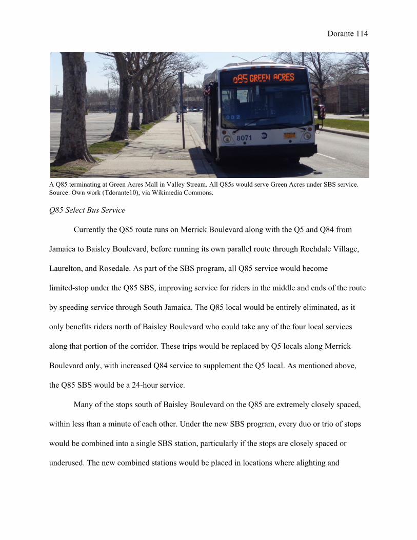
Dorante 114
A Q85 terminating at Green Acres Mall in Valley Stream. All Q85s would serve Green Acres under SBS service. Source: Own work (Tdorante10), via Wikimedia Commons. Q85 Select Bus Service
Currently the Q85 route runs on Merrick Boulevard along with the Q5 and Q84 from
Jamaica to Baisley Boulevard, before running its own parallel route through Rochdale Village,
Laurelton, and Rosedale. As part of the SBS program, all Q85 service would become
limitedstop under the Q85 SBS, improving service for riders in the middle and ends of the route
by speeding service through South Jamaica. The Q85 local would be entirely eliminated, as it
only benefits riders north of Baisley Boulevard who could take any of the four local services
along that portion of the corridor. These trips would be replaced by Q5 locals along Merrick
Boulevard only, with increased Q84 service to supplement the Q5 local. As mentioned above,
the Q85 SBS would be a 24hour service.
Many of the stops south of Baisley Boulevard on the Q85 are extremely closely spaced,
within less than a minute of each other. Under the new SBS program, every duo or trio of stops
would be combined into a single SBS station, particularly if the stops are closely spaced or
underused. The new combined stations would be placed in locations where alighting and

Dorante 115 boarding is most frequent, or where SBS infrastructure such as ticket machines can be easily
installed. This would require passengers to walk farther to the nearest bus stop, but would speed
travel times for the Q85 and create a service pattern more inline with BRT standards. For
instance, the nearby stops at Baisley Boulevard/Bedell Street and 127th Avenue (East Loop 1) in
Rochdale Village would be combined into a single intermediate stop, placed in the middle of the
block in front of the adjacent public school facility. The new “skipstop” pattern would be
similar to the changes implemented on the Q44 route in the Bronx when it was converted into an
SBS route in November 2015, in which several local stops along the Cross Bronx Expressway
were eliminated to streamline service. The only area where close stops would be maintained is 227
in Rochdale Village along Bedell Street (with the exception of the Baisley Boulevard stop), due
to the fact that residents of the complex must walk a block from their apartments to reach Bedell
Street, the sideeffect of the ingenious “Tower in the Park” design of the complex. At least ten
stops in either direction between Baisley Boulevard and the Rosedale station would be
consolidated into other stops, or eliminated altogether.
In addition to eliminating stops, the new Q85 should be rerouted in several areas on the
route with narrow roads and tight turns, to speed service and accommodate articulated buses. The
first alteration would be on the route in Springfield Gardens between Farmers Boulevard and
Springfield Boulevard. Currently, the route operates on 140th Avenue east of Rochdale Village
and Farmers Boulevard before turning south onto Springfield Boulevard and east onto Conduit
Avenue. A narrow street situated in an entirely residential area, 140th Avenue can barely
facilitate oneway traffic and cannot handle articulated buses; nor can the articulated buses make
227 “Q44 Select Bus Service Bronx Community Board 9: April 02, 2015,” (MTA, NYCDOT, 2015).

Dorante 116 the tight turns required on this portion of the route. Instead, the Q85 should be sent down
Farmers Boulevard, then directly onto Conduit Avenue, with the route on Springfield Boulevard
eliminated. This would take away direct service from passengers along 140th Avenue and
Springfield Boulevard, including students at the large Springfield Gardens High School Campus.
Travel times and passenger comfort, however, would be greatly improved with the route change
and the addition of articulated buses. Students from the high school would only have to walk a
short distance south to Conduit Avenue to take the bus. Passengers from the eliminated route
would have to walk a short distance to Farmers Boulevard, or take the Q3 or Q77 and transfer to
the Q5 SBS at Merrick Boulevard.
The second routing change would be near the Rosedale station for Jamaicabound Q85s.
In this area, westbound buses must make a sharp righthand turn and another sharp lefthand turn
in order to turn from the Sunrise Highway onto North Conduit Avenue and serve a bus stop at
230th Place in Laurelton. Articulated buses may not be able to handle these turns, especially if
traffic is high on Brookville Boulevard (the intermediate street between Sunrise and North
Conduit) which has only two narrow lanes in either direction. Buses should instead travel on
Francis Lewis Boulevard one block east, in front of the Laurelton LIRR station. While Francis
Lewis is equally narrow, the turns from the Sunrise Highway and onto North Conduit Avenue
are much smoother. This however would add two bus routes (the Q5B and the Q85) onto this
portion of Francis Lewis, and the turning Q85 could delay the Q5B and other traffic. An alternate
proposal would be to keep the Q85 SBS on Sunrise Highway until it naturally merges with North
Conduit Avenue. Under this plan, the 230th Place stop would be eliminated, and would have to be
consolidated with the next closest stop at 225th Street; passengers would have to walk through a

Dorante 117 shady and overgrown area along North Conduit, underneath the LIRR trestle and past an
industrial complex where sidewalk is not present for the entire length of the street.

Dorante 118 List of new routes along Merrick Boulevard
Of these possibilities, I recommend upgrading the Q4, Q5, and Q85 limited services to
Select Bus Service, creating the Q5H and Q5B and extending them to southern Rosedale, and
streamlining the 24hour Q85 SBS service now running to Green Acres. The Q85 local would be
eliminated, replaced with increased Q5 and Q84 local service. Weekend Q5 service to Green
Acres would be maintained by the Q5 local and the new Q5H, with the Q5B continuing to serve
Rosedale at this time. Under these plans, the service routes along the corridor would be:
Q4 Merrick/Linden Boulevards Local: Jamaica – Cambria Heights (all times)
Q4 Select Bus Service: Jamaica – Cambria Heights SBS (all times except late nights)
Q5 Merrick Boulevard Local: Jamaica – 231st Street weekdays; Jamaica – Green Acres
weekends; Jamaica – Rosedale Station late nights
Q5 Select Bus Service via Hook Creek / Francis Lewis (Q5H SBS): Jamaica – 253rd
street/149th Avenue via Francis Lewis weekdays; Jamaica – Green Acres weekends; no
latenight service
Q5 Select Bus Service via Brookfield / 243rd Street (Q5B SBS): Jamaica – 253rd
street/149th Avenue via 243rd Street (all times except late nights)
Q84 Merrick Bl/120th Avenue Local: Jamaica – Laurelton
Q85 Merrick Bl/Rochdale/Conduit Av Select Bus Service: Jamaica – Green Acres
(full route) or Rosedale Station (early mornings & short runs); Jamaica – Rosedale–147th
Avenue/243rd Street SBS late nights (replaces Q5 SBS)

Dorante 119
A 60foot Nova Bus LFS model, the standard bus used on SBS routes. Author: Own work (Tdorante10), via Wikimedia Commons. Features of Merrick Boulevard SBS
The Merrick Boulevard Select Bus Service would receive the standard SBS upgrades:
offboard fare payment, speciallybranded blue lowfloor buses, and transit signal priority along
Merrick Boulevard. TSP would be a key addition for all service along the corridor, compensating
for the numerous and poorlytimed traffic lights on the boulevard. Under the plan, new lowfloor
buses would be purchased or otherwise allocated to the corridor to expand and improve service.
Ideally the Q4, Q5 and Q85 SBS services would receive new threedoor articulated buses to
increase capacity and maintain BRT standards, though the routes could use standardlength buses
on a temporary basis as was done with the M34 SBS. Adding new and larger buses to the 228
corridor would require expediting the construction of the new Jamaica Bus Depot to
accommodate the additional vehicles.
With the prior controversy over bus lanes on Merrick Boulevard, the initial Merrick
Boulevard SBS would not feature dedicated lanes, relying on faster boarding and signal priority
to speed up service. However, should the service be successful and political opposition wane,
228 Stephen Miller, “Ridership Up 12 Percent on 34th Street, With More Improvements to Come,” (StreetsBlog NYC, 24 August 2012).

Dorante 120 busonly lanes would be a dramatic improvement for all traffic along the boulevard. Buses would
no longer have to precariously stop behind cars parked at the edge of bus stops or doublepark
due to stopping pads blocked by parked cars. Meanwhile, buses would no long obstruct other
traffic by taking up one or both mixedtraffic lanes during peak hours. Like most other SBS bus
lanes, the Merrick Boulevard lanes would be active only during peak hours. Depending on the
traffic needs of the boulevard, they could be offset (maintaining parking spaces), or curbside
(maintaining two lanes of traffic in either direction). In addition, bus stop pads should be
lengthened and “buffer” zones added between bus stops and parking spaces to prevent the
obstruction of bus operations by parked cars. Alternately, should offset bus lanes be installed,
stops along Merrick Boulevard could be converted into bus bulbs, extending the sidewalk out to
meet the bus lane. This would eliminate the need for buses to turn into the curbside lane and risk
getting wedged behind a parked car.

Dorante 121 Jamaica Center BRT Terminal
To better serve the corridor, as part of the implementation of Select Bus Service the old,
dilapidated, and openaired Jamaica Center Bus Terminal constructed along with the Archer
Avenue subway would be replaced with a railwaystyle bus rapid transit station serving all the
Merrick Boulevard routes, along with the Q83 and Q83 limited routes (currently using Bay D)
which also have significant ridership. The new terminal would be enclosed and farecontrolled,
with turnstiles installed at each end of the block (Parsons Boulevard to the east; 153rd Street to
the west) for passengers to pay their fare. This would be the second farecontrolled bus stop in
the city. The only other stop of this kind is located within the Rockaway Parkway subway station
in Canarsie, Brooklyn, used by the B42 between the station and Canarsie Pier at the Jamaica Bay
shoreline. Bus passengers at this station – either entering the station via the subway turnstiles or
exiting from the L train – simply board the bus, having already paid their fare. At Jamaica 229
Center, the current bus bays would be replaced with seven “gates” approximately 65feet in
length. Each gate would have three sets of platform screen doors that open when a bus is stopped
in front of it. The doors would allow the terminal to remain enclosed and temperature controlled
during winter and summer months, while preventing fare evasion by forcing passengers to enter
via the turnstiles. This would also remove the incentive for dollar vans to stop in the bus loading
area.
As opposed to the current setup, in which each separate service has its own bus bay, in
the new setup buses would pull up to the front most (easternmost) gate available, with the next
bus stopping behind it. This eliminates the need for passengers in the route overlap areas to
229 Hugh G. Muir, “Sonic 'Echo' Unit Stands Guard For SubwayBus Transfer,” (New York WorldTelegram, 7 December 1960).

Dorante 122 choose one bus bay and hope that bus arrives first. In addition, because the majority of transit
and commercial activity is concentrated at Parsons Boulevard, this would better serve the bulk of
passengers. The 153rd Street entrance at the west end of the terminal would be used primarily by
passengers transferring from services such as the Q44 Select Bus Service from northern Queens
and the Bronx or the Q24 from Brooklyn, and by travelers coming from the Queens Family
Court building. Ideally schedules should be shifted to allow
multiple buses to begin service simultaneously, giving passengers the option to enter any of the
arriving buses and not cluster at the front (eastern end) of the terminal. The new setup would do
away with the long lines to enter the bus via a single door, and allowing passengers to transfer to
an emptier bus when it pulls up, eliminating uneven loading. In a hypothetical scenario, two SBS
buses (one Q5 and one Q85) and one local bus (a Q5) could arrive first. Two minutes later, a Q4
SBS, a Q4 local and another Q5 local arrive, and so on. The Q84 would be moved from Bay F in
the Teardrop Canopy into the new terminal area, stopping in the same que as the other Merrick

Dorante 123 Boulevard routes. The Q83 could continue to stop in an isolated gate at the west end of the
terminal area, in order to avoid confusion with the Merrick Boulevard routes. The Q25, Q34 and
Q65, meanwhile, could share the Q30/Q31 stop at the end of the block, though it would be best
to eliminate the stop and allow these buses to run in the left lane along Archer Avenue to ease
traffic flow.
Proof of Payment System
The Jamaica Center BRT station would be the only farecontrolled stop along the new
Merrick Boulevard SBS routes; the remaining stops along the Q4, Q5, and Q85 SBS would still
utilize the standard SBS ticket machines. Because of this, passengers entering the Jamaica Center
station would need to receive proofofpayment in the event of regular fare inspection by NYCT
officials. To do this, the turnstiles at the BRT station would be designed to print and dispense
tickets to passengers. This could be done by retrofitting current turnstiles, or by designing
entirely new entry devices.
The proofofpayment tickets used at Jamaica Center would be an improvement upon the
current flimsy design, using thicker card stock instead of receipt paper. Because the tickets
would be used for multiple routes (currently, no SBS corridor features more than two services),
the bottom of the ticket would feature a list of all the routes at the terminal. Upon inspection,
NYCT officials would holepunch or mark the correct route on the ticket, as conductors do on
commuter trains. A mockup of the design is shown in Appendix C.

Dorante 124 Brewer Boulevard Corridor Improvements
New Q115 Jamaica – Rosedale Limited
Currently, residents along the Q111 route in eastern Rosedale do not have the benefit of
limitedstop service through South Jamaica towards Jamaica Center. While service is frequent,
this pattern forces these bus riders to either take the entirelylocal Q111 through the corridor, or
transfer to the Q113 or Q114 which are already full of passengers from Far Rockaway and
Nassau County. To provide better service to these passengers, a new limitedstop service to
Rosedale via 147th Avenue should be created, labeled “Q115”. Under this plan, the Q115 would
replace the Q111 along 147th Avenue in Springfield Gardens, Brookville and Rosedale,
providing speedier service to the isolated commuters in this area. The Q111 meanwhile would
only operate on Brewer Boulevard between Jamaica and Farmers Boulevard, continuing to
provide frequent local service to passengers in South Jamaica, Rochdale Village, and Springfield
Gardens. As opposed to calling the new service “Q111 Limited”, the two services would be
given different designations to avoid confusion, as was done with the Q114.
With this change, all service in the corridor operating on 147th Avenue would run
limitedstop along Brewer Boulevard towards Jamaica, giving optimal service to the most
isolated passengers along the corridor. On the portion of 147th Avenue shared between the Q114
and the Q115, the Q114 would retain its limitedstop service; the Q115 would run local through
the entire length of 147th Avenue. In addition, during evenings and overnights when the Q113 is
not running, the Q114 would continue to operate limited along Brewer Boulevard to maintain
speedy service to Nassau County and Far Rockaway. To maintain local service on Brewer

Dorante 125 Boulevard, the Q115 would run entirely local at these times along with the Q111; this would be a
service increase during this period, with three routes available on the corridor.
Depending on the ridership towards the outer terminals of the corridor (Rosedale for the
Q115; Nassau County and Far Rockaway for the Q114), the new Q115 service could be
implemented in two ways. In the first option, the Q115 would replace alternating Q114 runs. A
cost neutral option, this would be done if ridership proves to be low on the routes east/south of
Brewer Boulevard, or if funds are not available to increase the number of daily trips along the
corridor. The frequency of the Q113 would not be changed to maintain speedy service between
Far Rockaway and Jamaica. In this pattern, for every four limited buses, two would be Q113s,
with one Q114 and one Q115 (Q113, Q114, Q113, Q115, Q113, etc.…). During peak morning
rush hours for example, when a limited bus enters service every five minutes, the Q113 would
continue operate on tenminute headways. The Q114 and Q115, however, would now arrive
every twenty minutes, creating a major reduction in service for passengers in Rosedale for the
Q115, and Nassau County for the Q114; as currently constituted, the Q111 runs every three
minutes during the morning rush period, with two out of every three trips running all the way to
Rosedale. 230
The second option would implement the Q115 as additional trips along the corridor. In
the peak rush hour situation, for example, limitedstop service frequency would be increased
from two buses every ten minutes to three buses every ten minutes, or one limited bus every
threetofour minutes. This would create a less drastic service reduction for Rosedale passengers
during this period – from two Q111 buses every nine minutes to one Q115 bus every ten minutes
230 “Bus Timetable: Q111”; “Bus Timetable: Q113/Q114.”

Dorante 126 – which would be offset by the advantages of the new limitedstop service. Unlike the
conversion of the Q114, this second proposal Q115 would be a service increase, adding more
buses along the line. This would lead to an increase in operation costs, and may require
additional buses to be allotted to the Baisley Park Depot (the former Jamaica Buses garage) to
facilitate the service.
Modified versions of this proposal include:
Convert alternate Q114 buses into Q115 buses; continue to split Q111 trips between
Farmers Boulevard and Rosedale. The Q115 Limited would now be a supplement to
Q111 service, and limited stops could be instituted along 147th Avenue east of Brookville
Boulevard. With the Q115 only running every 20 minutes during peak service, however,
many passengers would still need to transfer at Brewer Boulevard to a limited service, or
ride the Q111 local all the way to their destination.
Implement Q115 as additional limitedstop trips; maintain current Q111 service.
This is the most ideal plan in terms of improving service, adding frequent limitedstop
service to complement to local service. This would also be the costliest option, however,
and service in this area may not be high enough to justify the expenditure necessary.
Out of these possibilities, I recommend truncating the Q111 to Farmers Boulevard and
instituting the Q115 Limited to serve Rosedale. At least on a temporary basis, the Q115 would be
implemented as a service expansion, adding limitedstop runs along the corridor. The Q114

Dorante 127 Limited would be expanded to operate alltimes, with the Q111 and Q115 providing local service
evenings and overnights. Under these plans, the service routes along the corridor would be:
Q111 Brewer Boulevard Local: Jamaica – Farmers Blvd (all times)
Q113 Brewer Bl/Nassau Expy Limited: Jamaica – Far Rockaway (no night service)
Q114 Brewer Bl/147th Av Limited, Nassau Local: Jamaica – Far Rockaway (all times)
Q115 Brewer Blvd Limited, 147th Av Local: Jamaica – Rosedale (local evenings and
overnights)
In addition to the changes in Southeast Queens, several other changes outside the study
area could improve service along the corridor for passengers from Nassau County and Far
Rockaway.
Widen Brookville Boulevard
Brookville Boulevard is a dangerous and inferior street crossing the wetlands between
Queens and Nassau County. The road has sizable traffic, and the Q114 must traverse the road in
order to serve Rosedale and Brookville. To improve safety for all motorists and commuters, the
city and state must go ahead with the plan to elevate the road onto a trestle and widen it to
accommodate additional QueensRockaway traffic. While this would necessitate construction on
the protected wetlands, the new sidewalled and gradeseparated road would have the added
effect of preventing future dumping along the road. The road trestle could also be built in
conjunction with a major cleanup program for the area.

Dorante 128 New Q114 and Q115 service in Cedarhurst and Valley Stream, Nassau County
Currently, there are four Q111 trips which terminate at Rockaway Turnpike and
Peninsula Boulevard in Cedarhurst. This service dates back to the route’s operation under
Jamaica Buses. Exactly who these trips serve is unclear, though based on gossip found in transit
forums and the scheduled departure times of the afternoon trips from Cedarhurst, they seem to be
designed to serve students of Lawrence High School at the Cedarhurst end of the route. These
trips run a highly illogical route in terms of serving passengers from Jamaica, continuing east and
south of Rosedale into Valley Stream, but then turning west along Peninsula Boulevard back
towards Rockaway Turnpike, intersecting with the Q113 and Q114. The distance traveled 231
along Peninsula Boulevard is just as long if not longer the distance traveled on 147th Avenue
between Brewer Boulevard and Rosedale. On the other hand, the pattern logically serves riders
from Cedarhurst to Valley Stream, connecting two neighborhoods geographically separated by
Hook Creek. Thus the Q111 Cedarhurst trips are essentially two routes (JamaicaRosedale and
Valley StreamCedarhurst) combined into a single trip.
If ridership is high enough, the runs could be reworked into two branches. The first
would run down either the Q113 (Rockaway Turnpike) or Q114 (Brookville Boulevard) routings
to Cedarhurst, then continue east along Peninsula Boulevard to either Mill Road and Peninsula,
or the Gibson LIRR station in Valley Stream, Long Island. This service would be labeled as
Q111 or Q114 depending on whether it runs local or limitedstop from Queens; under my
proposal, the runs would be Q114 Limiteds via Brookville. The second branch would be an
extension of the nowQ115 past Rosedale to the same terminal in Valley Stream. Both the
231 “Bus Timetable: Q111”; “NYCDOT Bus Ridership Survey and Route Analysis: Chapter 4”.

Dorante 129 Cedarhurst and Valley Stream junctions of the route would serve shopping centers. The
connection to the Gibson station also provides improved access to the LIRR for commuters in
the area without access to automobiles. Although the changes would take away onestop service
between Cedarhurst and Valley Stream, the new setup would expand ridership during the entire
day.
The extensions would serve an area currently without direct service from the Nassau
InterCounty Express (NICE Bus). The closest routes are the n31 and n32 buses between
Hempstead and Far Rockaway, which run farther south along West Broadway and
Broadway/Central Avenue respectively, parallel to the LIRR Far Rockaway Branch. Those
routes run individually on halfhour headways (collectively on 15minute headways). The new 232
MTA Bus routes would run on 1530 minute headways on weekdays, with schedules coordinated
at the Valley Stream terminal so that arriving Q114s line up with departing Q115s, or vice versa.
Potential weekend service would operate hourly. The major flaw in this proposal is expending
city money to expand service in areas not within the city’s jurisdiction. The two new routes
would be:
Q114 Brewer Bl/147th Av Limited, Peninsula Bl Local: Jamaica – Cedarhurst – Valley
Stream
Q115 Brewer Blvd Limited, 147th Av Local: Jamaica – Rosedale – Valley Stream
Improve bus stop signage along the Q111, Q113 and Q114 routes in Nassau County.
232 “Bus Timetable Effective as of January 17, 2016: n31/n32,” (Nassau InterCounty Express, January 2015); “System Map”, (Nassau InterCounty Express, 8 April 2012).

Dorante 130
While the Q111 only provides select service in Nassau County, the Q114 provides
24hour local service in Nassau County between mainland Queens and Far Rockaway. Both
routes, however, share the same characteristic of poorlyidentified bus stops or stops that are not
signed at all. For example, MTA Bus Time lists a stop for the Q111 at the northwest and
southeast corners of Peninsula Boulevard and Woodmere Boulevard, but there is no signage to
signify that buses stop at either corner. Potential passengers (those who know that the service and
stop exists) would theoretically have to flag down the bus, and hope that the driver acknowledges
them. The stops that are signed do not use either form of MTA signage, nor do they use the
smaller but still viable Long Island Bus/NICE Bus signs. Instead, these stops either read “NO
STOPPING BUS STOP” or “NO STOPPING ANY TIME”; the later form of signage gives no
indication that the nostanding zone is for bus service. It is safe to assume that due to the lack of
branding, many local residents may not know the bus routes exist or where they travel to, leading
to low ridership in these areas and making the Q114 a rolling waste of money.
It is wise to improve these bus stops, adding MTAstyle signage which uses a bold shade
of blue (therefore easily visible) and features the route number and schedules for bus service;
neither is currently provided. Preferably, the modern Europeanstyle bus signs should be used.
These signs, which feature destinations in addition to route numbers (for example, ”Q114 LTD –
Jamaica”), are better suited to attract new riders, in addition to the fact that they last longer than
the old metal bus stops. While it would require the MTA and the NYCDOT to spend money 233
outside the city limits, it would ultimately justify the money spent on operating bus service in
those areas.
233 Garry PierrePierre, “ColorCoded Bus Stop Signs Replacing Old, Cryptic Ones,” (The New York Times, 20 November 1998).

Dorante 131 Other Local Bus Improvements
Farmers Boulevard Corridor
The Farmers Boulevard corridor, served by the Q3 bus route, is the fourthbusiest
corridor in Southeast Queens serving over 3 million riders annually. Like the Merrick Boulevard
corridor, it cuts through the center of the study area, though running more southwesterly from
Jamaica to Springfield Gardens, connecting with nearly every major bus corridor in the area. The
Q3 also serves John F. Kennedy Airport, running south of Springfield Gardens into the Airport
proper, and terminating at Terminal 5; it formerly served all JFK passenger terminals directly
until April 2004 after the opening of AirTrain JFK. The Q3 is one of three bus routes to directly
serve the passenger area of JFK, along with the Q10 from Kew Gardens and Ozone Park, and the
B15 from Brooklyn. 234
While the Q3 has the potential to serve just as many riders as the Merrick Boulevard
corridor, it is inherently restricted by its route alignment. The Q3 begins at 165th Street Bus
Terminal, not directly served by any subway route, and only connects with the underused IND
Queens Boulevard Line along Hillside Avenue, while the Merrick routes are fed by both Archer
Avenue Lines. In addition, despite its high ridership and status as an airport connector, the Q3
does not feature any limitedstop service. Furthermore, most riders from Jamaica traveling to
JFK Airport would rather take the AirTrain directly to their terminal then the Q3. Thus, the only
contingencies of passengers that would take the Q3 to JFK are those within Southeast Queens,
and those coming from other eastern Queens areas via the Hillside Avenue bus corridor (the Q1,
Q36, and Q43 routes). For the later group of riders, however, this necessitates a long twostop
234 “Transit Committee Meeting: June 2012,” (MTA New York City Transit, June 2012).

Dorante 132 bus ride, traveling along the entirelylocal Q3, and making an additional transfer to the AirTrain
to reach their terminal.
To realize the potential of the Farmers Boulevard corridor, several service upgrades
should be made. First, limitedstop service should be added to the corridor, speeding service for
both local residents and JFKbound commuters. The new Q3 Limited when it operates would be
bidirectional, due to the line’s status as an airport connector. In addition, a new service should be
created combining the Hillside Avenue and Farmers Boulevard corridors. This service, labeled
“Q93”, would run from one of the three Hillside Avenue corridor terminals around Queens
Village and Floral Park west to Farmers Boulevard, then south along Farmers to JFK. This
would create a oneseat route for passengers from fareastern Queens to JFK, and for local
residents commuting between neighborhoods along the corridors. Due to the length of the new
route, the Q93 should ideally operate as limitedstop. It should also be evaluated to restore direct
service to the JFK terminals, similar to that executed by the buses serving LaGuardia Airport.
Changes to the Q6 and Q7 routes
The Q6 and Q7 routes are both former services of the Green Bus Lines company, now
under the MTA Bus umbrella. As mentioned above, the Q6 is the third busiest corridor in
Southeast Queens, employing peakdirection limitedstop service along Sutphin Boulevard on
the western end of the study area, running through South Jamaica and Springfield Gardens.
Limitedstop service was added to the route in 2010. The Q7, meanwhile, runs from the Euclid 235
Avenue subway station in East New York, Brooklyn along Rockaway Boulevard through South
235 “MTA Bus Company Committee Meeting: February 2010,” (MTA Bus Company, February 2010), pg. 3741.

Dorante 133 Ozone Park. It currently only operates in a small portion of the study area between the Van
Wyck Expressway and 150th Street, intersecting with the Q6 at 150th Street and
Rockaway/Sutphin Boulevards adjacent to Baisley Pond Park. South of this junction, both routes
serve separate cargo areas of John F. Kennedy Airport; the Q7 terminates at the end of 150th
Street at South Cargo Road near the passenger terminals, while the Q6 runs to the AMB Cargo
Center (JFK Building 77) at the northeastern end of the airport property near the Idlewild/Hook
Creek wetlands. The Q7 has the potential to serve a greater residential portion of Southeast 236
Queens, providing a connection to Aqueduct Racetrack and the Aqueduct Resorts World Casino,
Cross Bay Boulevard, and the IND Fulton Street subway at Cross Bay Boulevard and in East
New York.
To better utilize the Q7, the line should be rerouted away from the JFK cargo area. Under
my proposal, the Q7 would be extended past Baisley Pond Park along Baisley Boulevard, which
currently has no significant bus service except for a short segment of the Q85 route. The Q7
would be extended as far as Farmers Boulevard and Linden Boulevard at the St. Albans VA
Hospital and LIRR station. The new service would add a crosstown route serving St. Albans,
Rochdale, and South Jamaica. It would also provide direct access to August Martin High School
in Baisley Park for students coming from other areas of Southeast Queens; currently, the school
is only served by the northsouth Sutphin and Brewer Boulevard corridors running from Jamaica
Center. Should the LIRR Atlantic Branch be converted into a subway line, the new Q7 route
would become a feeder route from local residences, the VA Hospital, and the High School into
the subway station Baisley Boulevard and Bedell Street. To replace the Q7 at JFK, a new branch
236 “NYCDOT Bus Ridership Survey: Chapter 4,” pg. 58, 1011.

Dorante 134 of the Q6 would be created called the “Q6A”, running south of Rockaway Boulevard to South
Cargo Road. This new branch would replace shortrun Q6s which terminate at
Sutphin/Rockaway Boulevards during peakdirection service, and alternating Q6s during other
times. 237
Similar modifications to the Q6 and Q7 routes were originally proposed by Urbitran
Associates in 2004 for the NYCDOT, when the bus routes were still privately operated under
DOT subsidies. The Urbitran proposal suggested creating the Q6A to replace the Q7 at JFK, and
creating two new services from Euclid Avenue: an extended Q7 between Brooklyn and Green
Acres via Rockaway Boulevard and Conduit Avenue, and a new “Q96” between Brooklyn and
Cambria Heights via Linden Boulevard. The Q96 would have upgraded the Q9A/Q89 route
(another former Green Lines route), which was eliminated due to 2010 and was a poor
performing route under both Green Lines and MTA operation. 238
Extension of the Q60
When the Q89 (renamed from the Q9A under MTA operations) was discontinued in 2010
under the MTA’s systemwide budget cuts, it eliminated all local bus service on Linden
Boulevard west of Merrick Boulevard. The Q89 had experienced low ridership, due to the fact
that it only ran on weekdays between 10 AM and 5 PM with one bus per hour. Much of its route
paralleled its sister route the Q9 to South Ozone Park, itself an extremely low ridership route
237 “NYCDOT Bus Ridership Survey: Chapter 4,” pg. 58, 1011. 238 “NYCDOT Bus Ridership Survey: Chapter 4,” pg. 58, 1011.
Dorante 135 with about 1.6 million yearly riders in 2014. Because of this, the Q89 was setup to be a failure,
although its absence leave a viable bus corridor unserved. 239
To restore and improve service along this portion of Linden Boulevard, I propose
extending the Q60 bus route a short distance from its current terminus at the South Jamaica
Houses south and east to Merrick Boulevard via Linden. The Q60, another former Green Lines
route, runs along Queens Boulevard to East Midtown Manhattan via the Queensboro Bridge,
connecting the Downtown Jamaica hub, several commercial districts on Queens Boulevard
including Queens Center Mall, and Manhattan. Although entirely local and parallel to two major
subway lines, the Q60 is among the busiest routes in Queens (11th in 2004), increasing the
viability of the extension. Additionally, the Q60 could be extended farther east along Murdock
Avenue to serve isolated areas of St. Albans, particularly the Addisleigh Park district only served
by the Q42 shuttle route. The Q60 would terminate either at 180th Street near the current Q42
terminus, or at Farmers Boulevard to connect with the Q3 and Q83. The new extensions would
provide residents along Linden Boulevard and Murdock Avenue with direct access to the Q3 to
JFK, the subway, LIRR and AirTrain in Jamaica, and the commercial districts along Queens
Boulevard.
Outside of the study area, it should be evaluated to add limitedstop service for the Q60
along Queens Boulevard and other sections of the route. This would be similar to the Bx1
Limited along Grand Concourse in the Bronx, which has high ridership in spite of paralleling the
IND Concourse subway for most of its length.
239 “NYCDOT Bus Ridership Survey: Chapter 4,” pg. 58, 1011.

Dorante 136

Dorante 137 Express Bus Service Improvements
Express bus service in Southeast Queens is substandard in terms of both frequency and
scope of service, with only four routes sporadically operating during rush hours in the peak
direction. Aside from the necessary increase in trips during rush hours, several changes and
service expansions should be implemented to create better and more attractive service.
New QM21 routing and new QM91 service
Currently, the QM21 almost exclusively serves residents of the Rochdale Village
development, with the remainder of its short route running concurrent with the X63. Meanwhile,
nearby portions of Baisley Park, Rochdale, Springfield Gardens, and Brookville are without
express bus service. The QM21 should be reworked and split into several branches to better
serve local residents, with additional runs to improve service frequency.
The first change would be to shift the QM21 route outside of Rochdale Village onto new
streets to serve the western areas of Baisley Park, moving it off of Guy R. Brewer Boulevard.
West of its loop around the development, it would run along Baisley Boulevard to Rockaway
Boulevard. It would then split into two branches, one along Sutphin Boulevard (the current Q6
route), and a second branch (labeled “QM21A”) continuing along Rockaway Boulevard, then
turning north on 142nd Street (the current Q40 route). At Linden Boulevard, the routes would turn
west and join the X63 towards Manhattan. Only one QM21 stop would be discontinued, at
Brewer and Foch Boulevards serving the Baisley Park Houses and Cedar Manor Coop.
Passengers from these areas would have to walk a short distance north to Linden Boulevard for

Dorante 138 the X63, or south to Baisley Boulevard for the QM21, or simply take one of the local Brewer
Boulevard buses into Jamaica Center.
In addition, a new service would be implemented to serve Springfield Gardens and
Brookville. The route would begin at 232nd Street at the west end of Brookville Park. It would
then run west along 147th Avenue (the Q111/Q114/Q115 route), then northwest on Rockaway
Boulevard (the Q6 route) to join the new QM21 in Baisley Park. The new route would be labeled
“QM91”, and operate out of the Baisley Park Depot along with the QM21.
Beyond this, the three routes (QM21, QM21A, and QM91) would receive additional
stops along the Van Wyck Expressway service road and Queens Boulevard to provide service to
residents of South Jamaica, South Ozone Park, Richmond Hill, Briarwood, and Kew Gardens
which have minimal or no express bus service. Fourtosix stops would be added along the Van
Wyck, primarily at major roads. A stop on Queens Boulevard would be added in front of Queens
County Criminal Court (currently only served by the QM18). In addition, the three routes would
stop at the Briarwood and Union Turnpike stations, replacing the X63, X64, and X68 which
would now bypass these stops (see below).
Super express service and additional nonstop service
Passengers at the east ends of the X63, X64, and X68 routes in Rosedale, Cambria
Heights, and Queens Village respectively have extremely long commutes, with their bus routes
continuing to make stops throughout Southeast Queens before nonstop service begins on
Queens Boulevard. This is not unique to the area; routes in Northeast Queens have similarlylong
pickup sections before beginning nonstop service towards Manhattan. Several of these services,

Dorante 139 however, have a solution to better accommodate passengers at the far ends of the routes called
“Super Express” service. This service – particularly that seen on the QM8 which runs along
Union Turnpike, 188th Street, 73rd Avenue, the LIE service road, and 260th Street to Glen Oaks –
makes all stops at stops only served by that particular route, then runs nonstop on streets shared
with other routes. In the case of the QM8 super express, it makes stops along 260th Street, the
LIE, and 73rd Avenue, then runs nonstop on the 188th Street and Union Turnpike (shared with
the QM1, QM5, QM6, QM7, and nonsuper express QM8s). Super Express service dates back to
when the routes in Northeast Queens were all operated by Queens Surface Corporation. All but
one route (the QM4) employs some form of Super Express service, though only the QM8
employs the type of service described above. The Super Express concept was also employed 240
on the X21 in Staten Island, which began service in September 2014. 241
Super express service should be implemented along the long X63, X64, and X68 routes
to speed up the slow and unappealing service on these routes, to make the $6.50 premium fare
truly worth the money. For the X63 and X64, every second trip would be a super express run,
pickingup passengers at the eastern end of its route, then running nonstop through the rest of
Southeast Queens. The X63 super express would make stops in Rosedale and in Laurelton, then
run express along the rest of its route on Merrick Boulevard. The X64 super express would make
all stops along its Linden Boulevard route from its terminal in Cambria Heights to Farmers
Boulevard at the St. Albans LIRR station. It would then continue west on Linden Boulevard
running nonstop, instead of traveling the circuitous route along Farmers Boulevard and Liberty
240 “Queens Bus Map”; “Bus Timetable Effective Winter 2016: QM7/QM8,” (MTA Bus Company, January 2016). 241 Nicholas Rizzi, “'Super Express Bus' Would Whisk Staten Island Commuters to 42nd St.,” (DNAinfo, 28 March 2014);

Dorante 140 Avenue. Similar service would be created on the X68 route along Hillside Avenue. Passengers
on the skipped sections of the routes would still receive service from the X63, X64, QM21, and
QM91, which would be more frequent than current schedules. Commuters in these areas
however, particularly those on the X64 route in St. Albans and South Jamaica, may be better off
taking local bus routes into Downtown Jamaica and transferring to rail service. In addition to
this, all X63, X64, and X68 buses would run nonstop on the Van Wyck Expressway and Queens
Boulevard, due to the long distances the buses must travel.
New X67 route to Queens Village
A new branch of the X64 route would be created to serve the neighborhood of Queens
Village. This service, labeled “X67”, would split from the X64 route at Farmers Boulevard and
Murdock Avenue, running east on Murdock (the Q83 route), then north along or parallel to
Springfield Boulevard at least to Hempstead Avenue/Hempstead Turnpike near Belmont Park.
The route could extend as far north as the Queens Village LIRR station at Jamaica Avenue.
List of new express bus routes
The new express bus routes in the region would be:
X63 Rosedale/Merrick Boulevard Express: Rosedale – East Midtown
X63 Super Express (X63 SX or X63X): Rosedale – East Midtown
X64 Linden Blvd/Liberty Av Express: Cambria Heights – East Midtown
X64 Super Express (X64 SX or X64X): Cambria Heights – East Midtown
X67 Murdock Av/Liberty Av Express: Queens Village – East Midtown

Dorante 141
X68 Hillside Avenue Express: Floral Park – East Midtown
QM21 Rochdale/Sutphin Bl Express: Rochdale Village – East Midtown
QM21A Rochdale/142nd Street Express: Rochdale Village – East Midtown
QM91 147th Av/Sutphin/Rockaway Bl Express: Brookville/Springfield – Manhattan

Dorante 142
New intermediate stops on the express routes would serve the ElmhurstRego Park commercial district before heading towards Manhattan. New intraborough express bus service
Express bus services in New York City serve the sole purpose of feeding passengers into
Midtown and Downtown Manhattan. Isolated areas such as Southeast Queens, however, have
long trips not only to Manhattan but to all parts of the city, including commercial and job centers
within the same borough. Because of this, express bus routes from outer borough areas could be
expanded to add stops at major trip generators on their way towards Manhattan. In the case of the
Southeast Queens routes, a new dropoff zone would be created in Elmhurst and Rego Park just
before the routes enter the Long Island Expressway on their way towards Manhattan. This new
zone would give riders an additional transit option towards the Rego Center and Queens Center
Mall. Trips from the region to these shopping centers normally require one of two transit options:
taking buses into Downtown Jamaica, transferring to the E or F express services in Jamaica, then
transferring to the local M or R trains; or taking local buses to access the Q60 traveling along
Queens Boulevard, or the four buses along Woodhaven and Cross Bay Boulevards. The new
setup would create onestop service between Southeast Queens and the Elmhurst business

Dorante 143 district, particularly convenient for elderly and disabled passengers who would struggle with
multiple transfers and accessing the subway.
Under the new setup, Manhattanbound express buses would run nonstop on the Queens
Boulevard main (center) roadway until 63rd Road, where the buses would merge into the service
road and stop at the Rego Center. They would then stop at the foot of Queens Center Mall just
past Woodhaven Boulevard. The buses would Uturn onto Hoffman Drive (a dedicated bus stop
area), following the QM10 and QM11 routing onto the LIE; buses could make a pickup stop at
the QM10/QM11 stop, or bypass it. Coming from Manhattan, the routes would make pickups at
the foot of Queens Center, Uturn onto the eastbound Queens Boulevard service road, and make
pickups across from the Rego Center before proceeding to Southeast Queens. The new service
option would justify expanding service on the routes into midday hours. On weekends, the routes
could run primarily between the business district and Queens, with occasional trips into
Manhattan; currently there is no weekend express bus service to or from the region.