Improving the GFDL/URI Coupled Hurricane-Ocean Model for Transition to Operations Isaac Ginis
17
Improving the GFDL/URI Improving the GFDL/URI Coupled Hurricane-Ocean Coupled Hurricane-Ocean Model for Transition to Operations Model for Transition to Operations Isaac Ginis Isaac Ginis University of Rhode Island University of Rhode Island Thomas, URI J. Moon, URI Falkovich, NCEP Bender, GFDL Support is provided by JHT/USWRP
-
Upload
ulysses-savage -
Category
Documents
-
view
34 -
download
0
description
Improving the GFDL/URI Coupled Hurricane-Ocean Model for Transition to Operations Isaac Ginis University of Rhode Island. B. Thomas, URI I-J. Moon, URI A. Falkovich, NCEP M. Bender, GFDL. Support is provided by JHT/USWRP. - PowerPoint PPT Presentation
Transcript of Improving the GFDL/URI Coupled Hurricane-Ocean Model for Transition to Operations Isaac Ginis

Improving the GFDL/URI Improving the GFDL/URI Coupled Hurricane-Ocean Coupled Hurricane-Ocean
Model for Transition to OperationsModel for Transition to Operations
Isaac GinisIsaac GinisUniversity of Rhode IslandUniversity of Rhode Island
B. Thomas, URI I-J. Moon, URIA. Falkovich, NCEP M. Bender, GFDL
Support is provided by JHT/USWRP

GFDL/URI Coupled Model
Implemented to operations at NCEP in 2001 after Implemented to operations at NCEP in 2001 after three years of near-real time testing in 1998-2000three years of near-real time testing in 1998-2000
Improvements implemented in 2003: Improvements implemented in 2003: - New ocean model domain configurations New ocean model domain configurations - Ocean coupling over entire ocean domains Ocean coupling over entire ocean domains - Gulf Stream and Loop Current data assimilationGulf Stream and Loop Current data assimilation
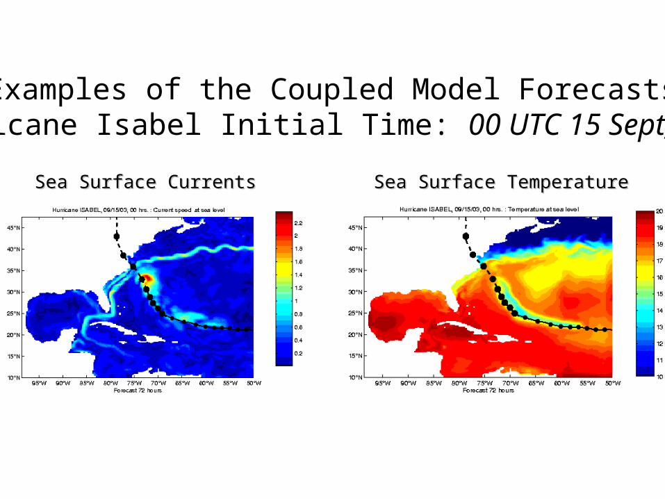
Examples of the Coupled Model ForecastsHurricane Isabel Initial Time: 00 UTC 15 Sept, 2003
Sea Surface CurrentsSea Surface Currents Sea Surface TemperatureSea Surface Temperature

Ongoing Efforts Toward Future Improvements
Ocean coupling in the Eastern Pacific basinOcean coupling in the Eastern Pacific basin
High resolution version of the GFDL modelHigh resolution version of the GFDL model
Air-sea flux parameterizationAir-sea flux parameterization
Coupled hurricane-wave-ocean systemCoupled hurricane-wave-ocean system

Hurricane IGNACIO 22-27 AUG, 2003

Hurricane Ignacio GFDL Model Forecast (12Z 24 AUG, 2003)
Red - OperationalGreen - CoupledBlack - Observed
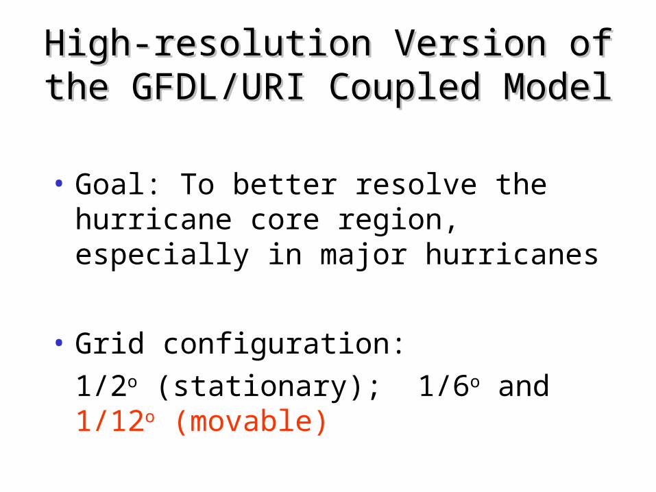
High-resolution Version of the High-resolution Version of the GFDL/URI Coupled ModelGFDL/URI Coupled Model
• Goal: To better resolve the hurricane core region, especially in major hurricanes
• Grid configuration:
1/2o (stationary); 1/6o and 1/12o (movable)

Hurricane Isabel, Sept 8 12Z, 2003
Operational GFDL model
High resolution GFDL model
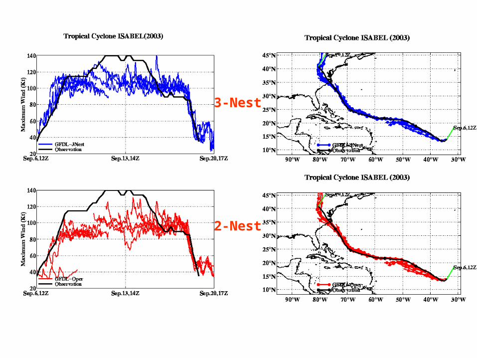
3-Nest
2-Nest
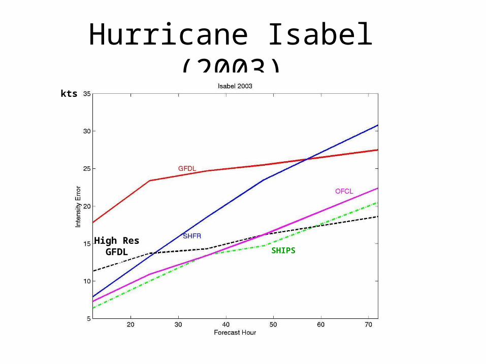
Hurricane Isabel (2003)kts
SHIPSHigh Res
GFDL
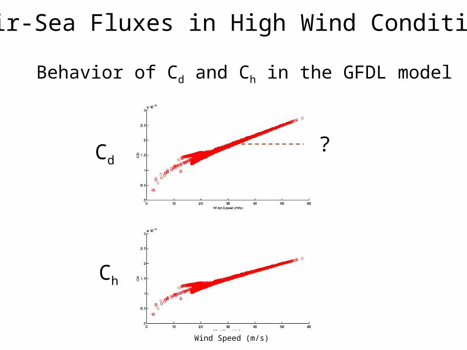
Air-Sea Fluxes in High Wind Conditions
Behavior of Cd and Ch in the GFDL model
?
Wind Speed (m/s)
Cd
Ch

Idealized Sensitivity Experiments

New Coupled Wind-Wave Model
young waves
mature waves

20 30 50
U10 (m /s)40
0
Powell et al. (2003) Large & Pond (1981)W W 3 (upper and lower bound)
3
1
Our results (upper and lower bound)
5
4
2
CD
* 1
000
Bulk, 0.0185
WW3
CWW

Wave Field in a Hurricane

GFDL(WRF)Hurricane Model
NCEPWAVEWATCH III
Flux
Wind &Air Temp.
Atmosphere
Ocean Waves
Currents,
Wave Boundary Model
SST
Wave Spectra
Flux
POM(HYCOM)
Wind &Air Temp.
Flux
GFDLHurricane Model
POM
SST &Current
SST
Flux
Atmosphere
Ocean
Elevations, & SST
Operational GFDL ModelOperational GFDL Model Future Coupled Hurricane-Wave-Ocean ModelFuture Coupled Hurricane-Wave-Ocean Model
Plans for Operational Implemantion
• Ocean coupling in the Eastern Pacific is planned for operational implementation in 2004
• The high resolution GFDL coupled model will be tested in near real-time in 2004 is planned for operational implementation in 2005
• The coupled GFDL hurricane-wave-ocean model is being developed