
Multimodal Transformer for Unaligned Multimodal Language ...

IMPLEMENTING MULTIMODAL TRANSPORTATION DISTRICTS
Connectivity, Access Management and the FIHS
This research was conducted under a grant from the Florida Department of Transportation.
FDOT Project Managers:
Gary Sokolow
Martin Guttenplan Joe Santos
The report was prepared by:
Kristine M. Williams, AICP Program Director, Planning and Corridor Management
Center for Urban Transportation Research University of South Florida, College of Engineering
4202 E. Fowler Ave., CUT 100 Tampa, FL 33620-5375
December 2001

CONTENTS
INTRODUCTION ......................................................................................................................... 3 MULTIMODAL STRATEGIES IN GAINESVILLE................................................................ 3
LONG RANGE TRANSPORTATION PLAN ....................................................................................... 3 CITY OF GAINESVILLE COMPREHENSIVE PLAN ........................................................................... 5 THE FIHS - SR 26 AND SR 331 ................................................................................................... 8 ISSUES ENCOUNTERED IN GAINESVILLE.................................................................................... 10
CONCLUSIONS AND RECOMMENDATIONS..................................................................... 12 SUMMARY.................................................................................................................................. 16 APPENDIX A – SAMPLE MULTIMODAL DEVELOPMENT REGULATIONS.............. 17
STREET PATTERN AND CONNECTIVITY...................................................................................... 17 GATED COMMUNITIES ............................................................................................................... 20 BICYCLE/PEDESTRIAN CONNECTIVITY...................................................................................... 20 BICYCLE ROUTES AND FACILITIES ............................................................................................ 22 UNIFIED ACCESS/JOINT AND CROSS ACCESS ............................................................................ 24 LIMITS ON DRIVE-THROUGHS.................................................................................................... 25 TRANSIT FACILITIES................................................................................................................... 26 PARKING .................................................................................................................................... 27 SUBDIVISION REVIEW REQUIREMENTS...................................................................................... 29 TND STREET DESIGN AND LAYOUT .......................................................................................... 30
APPENDIX B: SELECTED EXCERPTS OF THE EUGENE, OREGON CODE .............. 32 APPENDIX C: SAMPLE COMPREHENSIVE PLAN AMENDMENTS ............................ 45
CITY OF DESTIN, FLORIDA......................................................................................................... 45 REFERENCES ............................................................................................................................ 47

INTRODUCTION
This report explores issues in current practice as they relate to access management, multimodal objectives, and corridor management on the Florida Intrastate Highway System. The City of Gainesville was selected for review given the extensive efforts of the City and the Gainesville Metropolitan Transportation Planning Organization to promote a multimodal transportation environment. The findings of this study are intended to provide insight into implementation issues that surround multimodal transportation districts and potential solutions. In addition, sample land development regulations were identified as a first step toward the development of a model ordinance for multimodal transportation districts. The project was funded by a grant from the Florida Department of Transportation, Systems Planning Office.
The report begins with an overview of the planning and regulatory strategies employed by the City of Gainesville to promote a multimodal transportation environment and related efforts of the Gainesville Metropolitan Transportation Planning Organization. It proceeds with the implications of this analysis for multimodal transportation districts, particularly as they relate to access management and the Florida Intrastate Highway System. The report concludes with recommendations for implementing access management and multimodal districts and a menu of sample regulations to support multimodal transportation and development.
MULTIMODAL STRATEGIES IN GAINESVILLE
The City of Gainesville is the economic and institutional center of North Central Florida. It is home to quiet neighborhoods, busy commercial and industrial districts, an active downtown, one of the states largest medical facilities and the University of Florida. Past transportation decisions have shaped the current landscape of Gainesville. Suburban growth toward the west has been the trend in Gainesville for decades, resulting in longer commutes and increasing congestion. Most of this growth has been of a variety that requires a near absolute reliance on the automobile, placing a heavy demand on the existing road network and fueling the need for an ever-increasing expansion of roadway capacity.
Long Range Transportation Plan Understanding that today’s transportation decisions will shape the look and feel of the community in the future, the Gainesville Metropolitan Transportation Planning Organization pursued a decidedly different approach to long-range transportation planning than is typically applied. Rather than projecting future transportation needs based upon a fixed future land use scenario, as is the conventional approach, the MTPO used the long range transportation planning process to help define an integrated transportation and development vision for the future of Gainesville through extensive public involvement.
The public resoundingly rejected a future based on the existing land development trend of continued sprawl and reliance on the automobile and instead defined a vision of livable community centers and neighborhoods supported by a diverse and widely available multimodal transportation system. The vision is embodied in the 2020 Long-Range Transportation Plan (LRTP) adopted in December of 2000, entitled The Livable Community Reinvestment Plan, and is supported by three goals:
"It is very difficult, if not impossible, to have a corridor serve both high mobility and foster highly accessible places where people can gather.”
— Gainesville 2020 Long Range Transportation Plan

1. Develop and maintain a balanced transportation system that supports the economic vitality and quality of life in the Gainesville metropolitan area through expanded transportation choices, improved accessibility and the preservation of environmental, cultural and historic areas.
2. Develop and maintain a sustainable transportation system that supports and preserves the existing transportation network through compact development patterns, improved system management and operations, and inter-agency coordination.
3. Develop and maintain a safe transportation system for all users and neighbors of transportation facilities and services.
The guiding philosophy of The Livable Community Reinvestment Plan is to encourage expanded transportation choices in support of a sustainable development pattern. The concepts of multimodalism and corridor management are at the core of the guiding philosophy. The final cost feasible plan includes a balance between highway, transit and bicycle/pedestrian projects (see Figure 1). Projects include:
• Corridor capacity enhancements such as intersection improvements and median construction,
• Roadway extensions to increase connectivity and relieve existing pressure on congested roadway,
• Off road bicycle and pedestrian trails,
• Strategic lane reductions and the introduction of on-street parking and pedestrian/bicycle amenities,
• Premium transit services such as dedicated bus lanes, express bus service, superstops and an Intermodal Center to facilitate the transfer from one mode of travel to another.
In defining the transportation philosophy of the land use alternatives, the Plan states:
“There is an inherent conflict between the efficient movement of automobile traffic and the creation of an environment that is safe and inviting for pedestrians, bicyclists and transit users. It is very difficult, if not impossible, to have a corridor serve both high mobility and foster highly accessible places where people can gather. A corridor’s function falls somewhere along a continuum that ranges from a highly accessible, livable environment on one end to a high mobility context on the other end…Determining the function a corridor should serve and where it fits along this continuum should reflect the region’s land use objectives and transportation system needs.”1
Based on that philosophy, the region’s major corridors were grouped as follows:
• Regional mobility corridors (FIHS)
• Metropolitan mobility corridors
• High accessibility corridors
• Multimodal connector corridors
Regional mobility corridors (FIHS) could serve both high speed/high volume through traffic through limited/managed access and commuter-oriented transit service. Examples of non-freeway FIHS

corridors include portions of SR 26, SR 331 and SR 20. Metropolitan mobility corridors emphasize high-speed cross-town trips, primarily for commuter traffic (e.g. SR 24, US 441). High accessibility corridors are constrained for physical or policy reasons, accommodate local trips, and have an emphasis on bicycle, pedestrian and transit usage. A segment of SR 26 (University Avenue from W34th Street to Waldo Road) falls in this category as do a variety of downtown and residential streets. Multimodal connector corridors provide for a balance between automobile travel and safety/access of alternative modes. They generally have two through lanes with two-way center turn lanes, supported by bicycle, pedestrian and transit facilities. Generally non-local roads that do not fall into other categories are considered multimodal connectors.
Figure 1 Gainesville 2020 Long Range Transportation Plan.
City of Gainesville Comprehensive Plan The City of Gainesville Comprehensive Plan advances the concepts of multimodal transportation and access management in a variety of ways. The Land Use Element of the Gainesville Comprehensive Plan strives to reinforce multimodal transportation options by creating mixed-use activity center

destinations. The overall goal of the Transportation Mobility Element (draft to be adopted in early 2002) is as follows:
“Establish a transportation system that … implements the vision of the Year 2020 Livable Community Reinvestment Plan (Gainesville 2020 Transportation Plan) within the City of Gainesville. The transportation system shall provide equal attention to pedestrian, bicycle, auto and public transit needs. The system should provide vehicular, public transit and non-motorized access to activity centers, community facilities and neighborhood commercial areas. Safety and efficiency shall be enhanced by limitations and care in the locations of driveways, provision of sidewalk connections within developments and an overall effort to enhance pedestrian mobility throughout the community by improvement and provision of safe crossings, complete sidewalk and trail systems and sidewalks of adequate width to encourage pedestrian activity.”
The Transportation Mobility Element has nine supporting goals that further support this multimodal philosophy. These goals address a range of issues including creating an environment that promotes transportation choices, development of a “park once” environment at each activity center, and minimizing single-occupant vehicle trips within the metropolitan area. The Objectives and Policies of the Element call for new development and redevelopment requirements with an emphasis on multimodal interconnectivity, multimodal design standards, and multimodal system improvements. A sample of Objectives and Policies that support the development of a multimodal transportation network and access management include:
Policy 1.1.1: By 2010, the City shall modify University Avenue (SR 26) between downtown and the University of Florida (UF) to enhance the connection between these two areas, and promote transportation choice and livability. Such modifications may include sidewalk improvements, removal of travel lanes and excessive travel lane widths (in order to achieve wider sidewalks and on-street parking), installation of raised medians, infilling of surface parking fronting the Avenue with buildings, additional street trees, crosswalk improvements to make pedestrian crossings more safe and convenient, and additional on-street parking. This project shall include identification of alternative routes that can be used for non-local, non-destination trips along SR 26 (University Avenue).
Policy 1.1.3: By 2004, the City shall explore with FDOT, enhancements to N.W. 13th Street to increase the pedestrian and multimodal character of that corridor.
Policy 1.1.11: Site plans for new developments and redevelopment of non-residential sites shall be required to show any existing and proposed bicycle and pedestrian access to adjacent properties and transit stops.
Policy 1.3.2: The City shall coordinate with FDOT and Alachua County to implement Access Management.
Objective 1.4: Protect existing and future right-of-way from building encroachment to the extent that doing so promotes transportation choice.
Objective 2.1: Establish land use designations and encourage site plans that reduce trip distances.

Objective 3.2: Increase transit ridership.
Policy 4.1.1: The City shall strive to provide an interconnected bicycle system with a route to every major destination in the city.
Objective 6.1: Revise street design standards and continue installing street design features so that construction of new streets and repair of existing streets will create a safe, balanced, livable streets that can be used for all forms of travel – to the benefit of neighborhoods, local businesses, and the overall community.
Policy 7.1.4: Where appropriate, the City shall convert minimum car parking requirements to maximum requirements as a way to discourage car trips.
The Concurrency Management Element of the Gainesville Comprehensive Plan also carries out this multimodal philosophy, with a goal to, “Establish a transportation concurrency exception area (TCEA), which promotes and enhances urban redevelopment, infill development [and] a variety of transportation choices and opportunities including automotive, pedestrian, bicycle and transit…”2 The TCEA covers a majority of the City limits and is broken into two sub-areas, Zones A & B.
To encourage redevelopment of the eastern portion of the City and the area near the University of Florida (Zone A), development or redevelopment in Zone A must provide the following in order to meet the TCEA requirements:
• Sidewalk connections from the development to existing and planned public sidewalks along the development frontage,
• Cross-access connections/easements or joint driveways, where available and economically feasible,
• Deeding of land or conveyance of required easements along the property frontage to the City, as needed for the construction of public sidewalks, bus-turn out facilities and/or bus shelters,
• Closure of existing excessive, duplicative, or unsafe curb cuts or narrowing or overly wide curb cuts at the development site,
• Provide safe and convenient on-site pedestrian circulation such as sidewalks and crosswalks connecting buildings and parking areas at the development site.
The remaining parts of the TCEA (Zone B), must meet the same requirements as Zone A, plus additional development requirements depending upon the proportional impact of the new development on the roadway system. Those requirements will relate to the particular site and transportation conditions where the development is located. Multimodal requirements include, but are not limited to:
• Construction of bus shelters,
• Construction of bus turn-out facilities,
• Provision of bus pass programs provided to residents and/or employees of the development,
• Widening of existing public sidewalks to increase pedestrian mobility and safety,

• Deeding of land for the addition and construction of bicycle lanes,
• Provision of ride sharing or van pooling programs,
• Provision of park and ride facilities,
• Business operations that can prove to have limited or no peak hour roadway impact,
• Provision of shading through awnings or canopies over public sidewalk areas to promote pedestrian traffic and provide protection from the weather so that walking is encouraged,
• Enhancements to the City’s greenway system which increases its utility as a multimodal transportation route,
• Clustering of and design of the development for maximum density at the site which preserves open space, reduces the need for development of vacant lands, enhances multimodal opportunities, and provides transit-oriented densities or intensities.
• Construction of new road facilities which provide alternate routes to reduce congestion.
Additionally, the TCEA provides for additional regulation of automobile oriented development such as drive-through facilities, surface parking lots, car washes and gas stations to minimize the impact of these land uses on the transportation system in the TCEA area. The TCEA also regulates the visual characteristics of roadways in the area through streetscaping and landscaping standards in order to create a more appealing environment that supports multimodal transportation opportunities.
Access management in the City is primarily accomplished through the policies related to driveway closure and joint and cross access described above. Several Special Area Plan overlay districts have also been adopted by ordinance and include provisions to encourage reassembly of parcels and joint and cross access. City planning staff have been successful in eliminating or consolidating access through concurrency policies and overlay regulations on a case-by-case basis. The general access management requirements in the City of Gainesville Land Development Code are minimal and address basic limits on driveways and driveway design criteria.
The FIHS - SR 26 and SR 331 SR 26 is a major east-west corridor in Florida and therefore is designated as an FIHS facility, except for a segment between SR 331 and I-75 that runs through the heart of Gainesville. This segment of SR 26 goes by several local names, including 8th Avenue, Newberry Road and University Avenue. University Avenue forms the northern boundary of the campus of the University of Florida and connects downtown to the University area. Because of its proximity to downtown and the University of Florida campus, the community is working to assure that this part of Gainesville will grow into a destination and mixed-use activity center served by a multitude of transportation choices.
University Avenue/SR 26 is currently a four-lane roadway that carries a large amount of truck traffic and other non-destination, non-local traffic from areas east of the City of Gainesville to I-75 west of Gainesville. Congestion on the segment and its convenience as a direct east/west link to I-75 and designation as an FIHS facility to the east have raised questions as to the appropriate use and function of this corridor. City planning staff believe that enhanced sidewalks and bus service in the University Avenue corridor and the reduction of through movement lanes is consistent with the City’s commitment to improved multimodal opportunities, particularly given the proximity of this corridor to the University of Florida, an environment suited to an increased multimodal network.

The multimodal philosophy for the SR 26/University Avenue corridor was supported by an analysis of alternative east-west routes through Gainesville by Glatting, Jackson, et al., which concluded that a reduction in through lanes on University Avenue in the vicinity of the University of Florida would not adversely impact through movements in the City.3 The report found that the majority of traffic on SR 26 was movement from the east to I-75 to the west and that there was adequate alternative capacity on other roads to accommodate those movements in a more appropriate location through the City—particularly Williston Road or SR 331, which is a designated FIHS facility that connects to I-75 to the south (Figure 2). The report also concluded that strict access management standards and reasonable development controls are needed for the alternative bypass route (SR 331/Williston Road) to preserve its function and avoid the need for a new bypass.
Figure 2 Potential Bypass Route, Source: Glatting, Jackson, et al., West University Avenue Corridor Traffic Study – Final Report, 1999.
To advance the multimodal concepts, the Year 2020 Long-Range Transportation Plan identifies a project to reduce University Avenue from its current four-lane configuration to a two travel lane configuration with a two-way center left turn lane and widened sidewalks (Figure 3). It is envisioned that this reconfiguration of University Avenue will contribute to a more pedestrian friendly environment that would be supported by improved transit service. Related to this reconfiguration is the City’s implementation of a Special Area Plan with urban design features to enhance the corridor.

Figure 3 University Avenue Project (Gainesville Livable Communities Reinvestment Plan Summary)
Issues Encountered in Gainesville There are differences of opinion over the appropriate approach for implementing the activity center vision of the Livable Communities Reinvestment Plan. The concern relates to the Transportation Concurrency Exception Area (TCEA), which currently covers most of the City of Gainesville. Some feel that the TCEA area should be redrawn to encompass only Major Activity Center areas, thus forcing increased densities within those areas and discouraging, if not eliminating, development outside of the TCEA because of concurrency shortfalls.
Others are concerned that redrawing the TCEA boundaries to include activity centers could cause development to stagnate within the City, due to high infill costs in activity center areas and the potential for concurrency moratoria in other areas, and encourage continued sprawl in the County, where land is cheaper. 4 Some property owners within the Major Activity Centers have indicated that redevelopment opportunities would be very expensive. An example, according to City staff, is a property owner who owns 10-12 acres of outdated commercial stock within a Major Activity Center and is demanding $6+ million, a price that is currently out of line in the market.
In addition, the mixed-use activity center concepts of the Comprehensive Plan have not been supported by market forces.5 Several activity centers experienced decline and disinvestment during the planning period as newer commercial/retail centers were built in the city and the unincorporated county. Transportation concurrency had stymied redevelopment and infill, leading to the adoption of the TCEA. Also, most of the mixed-use categories were placed on existing, built commercial properties (eg shopping centers, strip commercial areas) and there was no interest in adding residential units to these sites. Another issue is that the minimum density requirements of the mixed-use categories were problematic, impeded by environmental constraints, small or substandard lots and barriers posed by existing developed sites.

The City hopes to address these various constraints to mixed-use activity centers by reducing the financial disincentives for the market. Reducing the TCEA could counter these efforts. Another strategy being pursued is adoption of urban design standards to ensure compatibility of new, higher density development with surrounding properties. In particular, the City hopes to integrate New Urbanism and Traditional Neighborhood Development principles into redevelopment projects.
City planning staff were not prepared to comment on the application of multimodal transportation districts, but felt that the requirements of the TCEA reinforce the City’s commitment to multimodalism. New development and redevelopment are required to contribute to a multimodal system through such mechanisms as improved sidewalk connections to adjacent properties and public transit facilities, new sidewalks both on and off-site, driveway consolidation and cross access, bus turnouts and shelters in some cases, improved site planning for enhanced multimodal access and other TDM strategies such as ridesharing programs, alternative work hours, and so on.
In December 2001, the MTPO Board discussed consistency issues between the City of Gainesville and Alachua County Comprehensive Plans and the MTPO’s Livable Community Reinvestment Plan. These issues related to the appropriate regulatory mechanisms needed to achieve the desired urban form to support the vision of the Livable Community Reinvestment Plan. Specifically, the discussion focused on potential modifications to the existing City of Gainesville Transportation Concurrency Exception Area (TCEA), the creation of a new TCEA in unincorporated Alachua County and the development of a Multimodal Transportation District (MMTD) around a limited number of mixed-use centers.
As a result of this discussion, the MTPO Board approved a motion to:
1) Request that the Gainesville City Commission and Alachua County Commission have their respective staff work together with MPTO and FDOT staff on the following issues:
a) Continue to work together in a joint planning effort to address consistency issues related to the City of Gainesville and Alachua County Comprehensive Plans and the MTPO’s Livable Community Reinvestment Plan;
b) Through the land development code, develop and implement tools, such as MMTDs, land development regulations and other incentive/disincentive tools that support the implementation of the Livable Community Reinvestment Plan, particularly the development of a limited number of mixed use centers;
c) Consider designating TCEAs within unincorporated Alachua County along the Archer Road Corridor (from US 441 west to Tower Road) that includes a specific plan to properly balance mixed-use centers and support multimodal transportation;
d) Develop recommendations for:
• Whether the City’s TCEA should be revised to provide incentives for growth to occur in a limited number of highly developed mixed use centers;
• How mixed use centers can support multimodal transportation, especially in TCEAs; and

• Whether City and County Comprehensive Plans should be revised to include a highly developed mixed use center land use category and designate a limited number of centers on the land use map and consideration of the appropriate number of activity centers within the unincorporated area of the County; and
2) Request that the Alachua County Commission increase the density and intensity of land uses along the length of the Archer Road corridor within the Gainesville Metropolitan Area to make it consistent with the Livable Community Reinvestment Plan.
CONCLUSIONS AND RECOMMENDATIONS
1. A clear statement of roadway function is critical to accomplishing corridor management objectives and is a necessary step in the transportation planning process for preserving the FIHS.
The importance of establishing a clear statement of roadway function among all agencies and stakeholders is evident in the Gainesville case example. This is exemplified by the contrasting designations of SR 26 from “high speed FIHS facility” to a roadway with primary emphasis on pedestrians, bicyclists and transit users. Such variation in use and function is not uncommon as a major highway transitions from rural to urban environments.
In Gainesville a decision was made to plan for those variations and reinforce them through the transportation and development program. As a result, efforts can be made to preserve alternate routes, including SR 331, through more restrictive access management, while providing a more pedestrian environment on SR 26/University Avenue to discourage it’s use for intrastate ease/west travel. However, neither the City nor the County currently have an adequate access management plan and policy for the alternate FIHS routes – a necessary next step.
It is essential to maintain continuity of the FIHS system for safe and efficient intrastate travel. However, as shown in the Gainesville example, this could be a somewhat less direct route where the potential path of high-speed, high-volume traffic conflicts with a multimodal district. The challenge for managing the FIHS and other key corridors on the state highway system is that conflicts between through traffic and non-through traffic functions are not always easily resolved. In areas where high traffic volumes on the FIHS coincide with non-through traffic functions in a community, three approaches may alleviate potential conflicts: 6
First, construction of a bypass road or designation of an alternative bypass route is an option in some instances. With traffic diverted onto a bypass, the main roadway’s design could primarily accommodate non-through traffic functions, as in the University Avenue/SR 26 example above. However, in areas where uses within the urbanized area generate the majority of trips, traffic pressure along the roadway segment may not be reduced significantly. Further, although the majority of through traffic may be diverted to the bypass, the main roadway may still require improvements to enhance safety and aesthetically integrate with the surrounding environment. In addition, high levels of access control will be needed on any bypass route to preserve its ongoing function as a through route.

Second, improvements, usually in the form of widening and median reconstructions, can be made to the roadway with priority given to the through traffic function. Although the design should incorporate higher levels of access control and pedestrian and bicycle safety techniques, increased speed and width along the improved corridor may still decrease safety and pose a barrier for these users. This is the option being pursued for much of the FIHS, including improvements to segments of US 19 – a key north/south FIHS corridor.
Third, roadway improvements can be made to facilitate non-through traffic functions. In this approach, pedestrian crossings are improved, space for cyclists is increased, access spacing is somewhat lower to reinforce block spacing (eg, 440 ft or 660 ft), and greater emphasis is placed on traffic safety rather than speed. Although priority is given to non-through traffic functions, the overall goal is to design a system where vehicles can still flow into, out of, and through the urbanized area without congestion. This option would require a greater emphasis on context sensitive design for the FIHS where it bisects urban activity center areas/multimodal transportation districts and a bypass route is not an option.
2. Many FIHS facilities will have a barrier effect on pedestrian and bicycle mobility, but they are well suited to serve as express bus corridors.
Many FIHS facilities, given their width and the volume and speed of traffic, have a barrier effect on pedestrian and bicycle activity. Alternative modes of transportation are best accommodated by internalizing retail and service activity off of the FIHS and other major arterial roadways and into activity centers or onto minor arterial and collector roadways. These roadways can be more effectively oriented toward pedestrians and are not as essential for higher speed through traffic. Highway oriented uses may be located so they are visible and easily accessible from the arterials.
Transit service should be focused on two or four lane sections, as six lane sections are hazardous to cross and discourage pedestrian activity.7 However, six lane FIHS facilities could effectively serve as express bus corridors, provided there is careful attention to the location and design of bus stops and transfer facilities to assure pedestrian safety and minimize adverse impacts on through traffic movement.
3. The access spacing standards of the FIHS can be met without compromising multimodal transportation objectives and can be reinforced through multimodal transportation districts.
As demonstrated in Gainesville, access management and multimodal objectives are highly compatible - particularly in terms of joint and cross access, unified access and circulation requirements for activity centers, supporting street connectivity, and use of raised medians. For example:
• Raised medians help to enhance pedestrian safety by accommodating midblock crossings where block or crosswalk spacing is otherwise excessive.8, 9 Landscaping in the median also helps improve the aesthetic appearance of major corridors.
• Mixed-use activity centers create transit/pedestrian destinations and are more consistent with access management principles than strip development.
• Reduction of driveways and improvements to driveway design improve safety by minimizing conflicts between bicycles, pedestrians and vehicular traffic.

• Smaller blocks and a balanced, connected network of streets and sidewalks will make an area more pedestrian, bicycle, and transit friendly, while increasing opportunities for alternative access.
One potential area of conflict relates to multimodal objectives for small blocks and numerous local street connections to support walking, bicycling and transit use. With access management, all access connections, including local streets, should conform to the adopted spacing interval. Minimizing the number of street connections helps to minimize conflicts on the major roadway and preserves safety and efficiency of the major roadway.
The FIHS provides for access spacing standards that range from ¼ mile (>45 mph) or 660 ft. (< 45 mph) in less urbanized areas (Access Class 2), to 440 feet (< 45 mph) or 660 feet (>45 mph) in urban areas (Access Class 3). The latter category would accommodate a reasonably dense network of local streets and is therefore consistent with the multimodal district concept. Where blocks exceed 660 feet in length, mid-block crosswalks and pedestrian cut-throughs should be considered – particularly where they would provide more direct access to transit stops (see Figure 4). Where smaller blocks are desired, local streets that do not conform with access spacing standards could be designed as a cul-de-sac where they abut the arterial, with a cut through provided for pedestrians and bicyclists to the arterial roadway.
.
4. Local governments should enact measures to increase the density and connectivity of street networks to support multimodal transportation, access management, and corridor management objectives.
Street systems have become less connected and more random than the grid or modified grid networks typical of past development styles. Streets now tend to wind more and have fewer connections or intersections. In addition, many mixed-use projects have focused on internal organization while neglecting the need for pedestrian circulation and connectivity with the surrounding street system. Smaller blocks and a balanced, connected network of streets will make an area more pedestrian, bicycle and transit friendly. A denser, more diverse transportation network will also provide greater opportunities for alternative access and help remove local trips from designated through traffic routes.
Most access classifications on the state highway system could accommodate a reasonably dense network of local and collector streets.
Arterial
Transit stop
Cul-de-sac
Sidewalk Cut-through
Figure 4 Sidewalk cut-through to major roadway and transit stop.

To accomplish this, local land development regulations should incorporate language implementing the following:
• Provisions for the extension and continuation of arterials, collectors, and local streets,
• Connectivity of internal streets with existing or planned streets surrounding the development,
• Limitations on cul-de-sacs,
• Street spacing and block perimeter standards that conform with adopted access spacing standards.
Appendices A and B provide sample regulations on these subjects that could be adapted for local use.
5. Local governments should incorporate measures into the land development code to promote a safe, connected and continuous system of bicycle, pedestrian and transit facilities.
Regulations could require:
• Pedestrian connections from the development to public sidewalks, parking areas, and transit stops,
• Pedestrian ways connecting adjacent buildings,
• Conveyance of easements for construction of pedestrian, bicycle, and, transit facilities,
• Elimination of excessive or unsafe curb cuts, and
• Joint driveways, cross access connections, and unified access and circulation plans.
Appendices A and B provide sample regulations on these subjects that could be adapted for local use.
6. Careful attention to urban design and market incentives will be critical to accomplishing mixed-use, higher-density urban activity centers.
Historically, many communities have responded to traffic by reducing density or by keeping densities low. Ironically, the traffic problem is attributable to growth in single occupant vehicle travel, which is a byproduct of low density, single use development patterns. Alternatively, higher densities accommodating a mix of uses are necessary to sustain alternative modes of transportation.
Unfortunately, density has become a key public indicator of good and bad in local zoning decisions. The real issue, however, is not density; it is the character of development. Higher densities and infill can add to the character of a community and neighborhood provided there is careful attention to urban design, landscaping, and layout. Maximum allowable densities should also be reasonable for the context of the surrounding area.
In addition to neighborhood resistance to density increases, the higher cost of redevelopment and infill in urban areas is an ongoing impediment to implementing mixed-use activity centers. The experiences of the Gainesville area discussed earlier in the report are indicative of the challenges that other communities will face. How the City of Gainesville and Alachua County resolve these issues will have implications for multimodal transportation districts.
The City plans to adopt urban design guidelines to assure compatibility with the surrounding

neighborhood and to promote development styles that enhance rather than detract from neighborhood character. Financial incentives are also being explored. It is hoped that this will increase the economic viability and attractiveness of these areas for new redevelopment projects and residential uses in commercial activity center areas. Potential financial incentives include community redevelopment areas/tax increment financing districts, impact fee credits, and publicly funded improvements to area infrastructure and streetscapes.
SUMMARY
Early agreement on roadway function in the transportation planning and improvement process will help to integrate transportation and land use actions for more effective corridor management. Statements of roadway function should be included in agency plans and detailed enough to clarify how the agency will address potential conflicts between through traffic and non-through traffic functions on the FIHS.
Different access management policies and spacing criteria will be appropriate in areas planned for multimodal activity, such as multimodal transportation districts, versus areas planned for through traffic, such as bypass routes. The current FDOT access classifications for FIHS facilities (Classes 2 and 3) can largely accommodate these variations. However, where a multimodal district or downtown straddles the FIHS, difficult trade-offs may need to be made. This may involve acceptance of reduced safety for alternative modes or designs and strategies to reduce the speed of through traffic.
Multimodal transportation can be readily promoted through the land development process. However, resolving financial or policy disincentives to higher density, infill development will continue to be challenging, given the availability of cheaper alternatives on the fringes of metropolitan areas. Multimodal strategies can be most readily accomplished in newly developing areas, provided land development regulations incorporate the necessary requirements. Redevelopment of older urban areas to achieve higher density and a mix of uses will likely require more effective policy and financial incentives and greater attention to urban design than has been typical in many local plans and regulations. The design guidelines of new urbanism offer effective guidance in this regard.
Local governments should carefully consider how they will increase the density and connectivity of local and collector streets to support multimodal activity and increase access control on higher priority corridors. The appendices of this report provide regulatory language that local governments can use to support multimodal transportation and other corridor management objectives. Emphasis is placed on accomplishing connectivity and continuity of streets and site circulation, pedestrian and bicycle systems, and transit facilities. Additional information on local access management policies is available at www.cutr.usf.edu under Research Programs, Access Management.

APPENDIX A – SAMPLE MULTIMODAL DEVELOPMENT REGULATIONS
Street Pattern and Connectivity Wilmington Area Planning Council
Network density. Local streets shall be designed to discourage through traffic; but to encourage linkages between neighborhoods, and access to community facilities, shopping, and schools. Provisions for the extension and continuation of arterial streets and collectors into and from adjoining areas with an average one-half mile grid or equivalent route density is required in reasonable conformity to the Middletown Comprehensive Development Plan to the Delaware Department of Transportation Long Range Transportation Plan and the Wilmington Area Planning Council Metropolitan Transportation Plan. Marginal access streets should be provided where necessary, based on proposed uses and loadings.
Interconnection preferred. Local Street patterns should be comprised of short inter-connected streets with direct routes. Loops are preferred to cul-de-sacs. Streets in commercial and industrial areas should be laid out so as to create to the greatest extend possible a pedestrian circulation pattern and scale while still accommodating truck traffic, especially with regard to corner and horizontal curve radii, and intersection design.
[Wilmington Area Planning Council. Wilmapco Mobility Friendly Design Standards. November 1997. Appendix E: Middletown Zoning Recommendations, Section 7B(1).]
Fort Collins, CO
Network Density and Street Spacing.
Spacing of Full Movement Collector and Local Street Intersection With Arterial Streets. Potentially signalized, full-movement intersections of collector or local streets with arterial streets shall be provided at least every one thousand three hundred twenty (1320) feet or one-quarter (¼) mile along arterial streets, unless rendered infeasible due to unusual topographic features, existing development or a natural area or feature. State Highway Access Control Code or specific access control plan adopted according to that code shall determine the location of collector or local street intersections with state highways. [Fort Collins Land Use Code. Section 3.6.3 (C).]
Spacing of Limited Movement Collector or Local Street Intersections with Arterial Streets. Additional nonsignalized, potentially limited movement, collector or local street intersections with arterial streets shall be spaced at intervals not to exceed six hundred sixty (660) feet between full movement collector or local street intersections, unless rendered infeasible due to unusual topographic features, existing development or a natural area or feature. [Fort Collins Land Use Code. Section 3.6.3 (D).]
Distribution of Local Traffic to Multiple Arterial Streets. All development plans shall contribute to developing a local street system that will allow access to and from the proposed development, as well as access to all existing and future development within the same section mile as the proposed development, from at least three (3) arterial streets upon development of remaining parcels within the section mile, unless rendered infeasible by unusual topographic

features, existing development or a natural area or feature. The local street system shall allow multimodal access and multiple routes from each development to existing or planned neighborhood centers, parks and schools, without requiring the use of arterial streets, unless rendered infeasible by unusual topographic features, existing development or a natural area or feature. [Fort Collins Land Use Code. Section 3.6.3 (E).]
Conformance with Master Street Plan: Streets on a project development plan or subdivision plat shall conform to the Master Street Plan where applicable. All streets shall be aligned to join with planned or existing streets. [Fort Collins Land Use Code. Section 3.6.2 (A), Street Pattern and Connectivity Standards.]
Street connectivity (general): The local street system shall provide multiple direct connections to and between local destinations such as parks, schools and shopping. Local streets must provide for both intra- and inter-neighborhood connections to knit developments together, rather than forming barriers between them. The street configuration within each parcel must contribute to the street system of the neighborhood. [Fort Collins Land Use Code. Section 3.6.3, Street Pattern and Connectivity Standards.]
Continuation of streets and local street spacing: All development plans shall incorporate and continue all sub-arterial streets stubbed to the boundary of the development plan by previously approved development plans or existing development. All development plans shall provide for future public street connections to adjacent developable parcels by providing a local street connection spaced at intervals not to exceed six hundred sixty (660) feet along each development plan boundary that abuts potentially developable or redevelopable land. [Fort Collins Land Use Code. Section 3.6.3 (F), Street Pattern and Connectivity Standards.]
Note: Where connecting to an arterial roadway, the spacing interval for local streets should equal or exceed the adopted connection spacing standard for roadways of that access category.
Limitations on private drives: Private drives shall be allowed in a development, provided that their function will only be to provide access to property within the development or additional cross-access between developments that are also connected by a street(s). Private drives shall not be permitted if (by plan or circumstance) such drives would, in the judgment of the City Engineer, attract "through traffic" in such volumes as to render such drives necessary as connections between developments, neighborhoods or other origins and destinations outside of the development plan. A private drive shall not be permitted if it prevents or diminishes compliance with any other provisions of this Land Use Code. [Fort Collins Land Use Code. Section 3.6.2 (L)(1)(a), Street Pattern and Connectivity Standards.]
City of Federal Way, WA
Street Spacing: Spacing between adjacent intersecting streets, will be per the City of Federal Way Access Management Standards, found in Section 3.2.13.
Alignment and Connectivity: Proposed streets and other primary accesses will be aligned with existing streets. Street alignments will relate where practical to natural topography and will be selected so as to minimize grading and avoid excessive runoff. Alignment and connections of newly

constructed public streets will be provided in accordance with the following conditions, unless otherwise prohibited:
1. Street connection will be provided to any existing public street or right of way “stub” abutting the proposed development.
2. Pedestrian and emergency access will be provided to any abutting public school, public building, public park, trail, bikeways or transit stop.
3. Streets will be located for the development of adjoining land.
4. Block perimeters should be no longer than 1,320 feet for non-motorized access and 2,640 feet for streets.
5. More than one connection to the existing public street system will be provided for any development, or part thereof, of four acres or more, or generating more than 250 trips per day or more (25 single-family lots). If not otherwise infeasible, each connection will be to a different street.
[City of Federal Way, Public Works Development Standards, June 2001.]
Note: The City of Federal Way has found block perimeter standards to be more effective than block length standards as they can accommodate variations in terrain and other constraints without the need for a variance and do not necessarily require grid systems. Rick Perez of the City advises not to apply such criteria to all zones as some will require larger blocks. In addition, nexus challenges (Dolan v. City of Tigard) could occur in that this could result in right-of-way dedication far in excess of that required to accommodate the new trips generated by the development (especially in low-density zones). Additional information on how to address this issue can be found in the CUTR report Managing Corridor Development – A Municipal Handbook at www.cutr.usf.edu.
Wilmington Area Planning Council, DE
Block Length. Block length shall be between two hundred (200) and five hundred (500) feet. Considerations in establishing the length, width, and shape of blocks should be determined with due regard to the mobility friendly policies of the Middletown Comprehensive Development Plan, provision of adequate sites for buildings of the type proposed, zoning requirements, topography, attractiveness, and requirements for safe and convenient vehicular and pedestrian circulation. For blocks greater than 500 feet in length, or where access to a school or shopping center is necessary, a mid-block crosswalk with a minimum right-of-way of ten feet and a paved walk of five feet in width shall be provided.[Wilmington Area Planning Council. Wilmapco Mobility Friendly Design Standards. November 1997. Appendix F: Middletown Subdivision Recommendations. Section F6 (a-e).] Fort Collins, CO
Cul-de-sacs. Cul-de-sacs shall be permitted only if they are not more than six hundred sixty (660) feet in length and have a turnaround at the end with a diameter of at least eighty (80) feet. Except as provided in above for cul-de-sacs, no dead-end streets shall be permitted except in cases where such

streets are designed to connect with future streets on adjacent land, in which case a temporary turnaround easement at the end of the street with a diameter of at least eighty (80) feet must be provided. Such turnaround easement shall not be required if no lots in the subdivision are dependent upon such street for access.[Fort Collins Land Use Code. Section 3.6.2, Streets, Streetscapes, Alleys and Easements.]
Wilmington Area Planning Council, DE
Cul-de-sacs. Cul-de-sacs shall not exceed two-hundred and fifty (250) to five hundred (500) feet in length depending on density and topography. A less dense development may have longer cul-de-sacs. Pedestrian connections shall be provided between cul-de-sacs and other cul-de-sacs, collectors, and minor arterials, and between public facilities as identified in Section 5(C)(2)(o) of this ordinance. [Wilmington Area Planning Council. Wilmapco Mobility Friendly Design Standards. November 1997. Appendix F: Middletown Subdivision Recommendations. Section F6 (a-e).]
Gated Communities Fort Collins, CO
Gated entrances prohibited. Gated street entryways into residential developments shall be prohibited. [Fort Collins Land Use Code. Section 3.6.2 (G), Street Pattern and Connectivity Standards.]
Bicycle/Pedestrian Connectivity Clark County, Washington
Sidewalk connections: An on-site pedestrian circulation system shall be provided that links the street and the primary entrances of the structures(s) on the site. Sidewalks or pedestrian ways must connect the required pedestrian system to existing pedestrian systems on adjacent developments if adequate safety and security can be maintained. Convenient pedestrian access to transit stops shall be provided. [Clark County Code, Title 18 “Zoning”; Mixed-use district (MX) Sec. 18.320.070 (L)(1). January 1995.]
Oregon Department of Transportation
Purpose: The purpose of this section is to provide for safe and convenient pedestrian, bicycle and vehicular circulation consistent with access management standards and the function of affected streets, to ensure that new development provides on-site streets and accessways that provide reasonably direct routes for pedestrian and bicycle travel in areas where pedestrian and bicycle travel is likely if connections are provided, and which avoids wherever possible levels of automobile traffic which might interfere with or discourage pedestrian or bicycle travel. [Oregon Department of Transportation. Section 660-012-0045 (3).]
Bicycle and pedestrian access to adjacent areas: On-site facilities shall be provided which accommodate safe and convenient pedestrian and bicycle access from within new subdivisions, multi-family developments, planned developments, shopping centers, and commercial districts to adjacent residential areas and transit stops, and to neighborhood activity centers within one-half mile of the development. Single-family residential developments shall generally include streets and accessways.

For the purpose of this section, “safe and convenient” means bicycle and pedestrian routes, facilities and improvements which:
1. Are reasonably free from hazards, particularly types or levels of automobile traffic which would interfere with or discourage pedestrian or cycle travel for short trips;
2. Provide a reasonable, direct route of travel between destinations, such as between a transit stop and a store; and
3. Meet travel needs of cyclists and pedestrians considering destination and length of trip and considering that the optimum trip length of pedestrians is generally ¼ to ½ mile. [Oregon Department of Transportation. Section 660-012-0045 (3)(b)-(d).]
Pedestrian access through parking lots: Pedestrian circulation through parking lots should generally be provided in the form of accessways. [Oregon Department of Transportation. Section 660-012-0045 (3)(b)-(d).]
New Jersey Transit
Pedestrian cut-throughs. Pedestrian-way easements 10 feet wide, through the center of blocks more than 660 feet long, may be required by the approving agency in order to provide convenient pedestrian access to transit stops, a station, to shopping, or other community facilities. [Planning for Transit-Sensitive Communities, Appendix B, Model Site Plan Approval Ordinance for Station Area Overlay Zone; pedestrian easements, Sec. 12.4.4(c).]
Wilmington Area Planning Council
Provision of public space. Public space shall be provided as part of all new shopping center and office development in an amount that covers no less than five (5) percent of the total site area. Public space includes parks and plazas, pedestrian amenities such as seating, lighting, special paving, planting, artwork and special recreational features but excludes pedestrian walkways and required buffer areas.
Pedestrian access to building entrances and transit stops: Pedestrian walkways shall form an on-site circulation system that minimizes the conflict between pedestrians and traffic at all points of pedestrian access to on-site parking and building entrances. Pedestrian walkways shall connect building entrances with the public right-of-way and existing or planned transit stops. Pedestrian walkways shall be provided when the pedestrian access point or any parking space is more than 75 feet from the building entrance or principal on-site destination as follows:
• All developments which contain more than one building shall provide walkways between the principal entrances of the buildings; and
• All non-residential buildings set back 100 feet or more from the public right-of-way shall provide for direct pedestrian access from the building to buildings on adjacent lots.
Vehicular and pedestrian cross access: Vehicular and pedestrian access points at property edges and to adjacent lots shall be coordinated with existing development to provide vehicular and pedestrian circulation between developments. Buildings, landscaping, fences and other

improvements shall be located to that adequate area shall be reserved for future connections to adjacent properties and as not to preclude future site-to-site connections.
Internal pedestrian circulation: Internal pedestrian circulation within new office parks and commercial developments shall be provided through clustering of buildings, construction of accessways, walkways, and similar techniques.
[Wilmington Area Planning Council. Wilmapco Mobility Friendly Design Standards. November 1997. Appendix E: Middletown Zoning Recommendations, Section 4H(1)(e)(vi)(2).]
Bicycle Routes and Facilities Santa Clara Valley Transportation Authority, CA
Bicycle boulevards: Residential streets meeting the following conditions are optimum locations for Bicycle Boulevards:
• Existing low vehicle volumes;
• Very little commercial frontage;
• Roadway is parallel to a major arterial or a high-traffic collector street (within approximately 0.25 mile);
• Not a transit or truck route
• Roadway is reasonably continuous, i.e. it extends over at least two miles; it should have few jogs with main segments at least 0.5 miles long.
The following treatments on a residential or local street will provide a very convenient, efficient through route for all types of bicyclists:
6. Installing traffic control devices so that bicyclists on bike routes can easily cross major streets and arterials.
7. Whenever possible, STOP signs are positioned so that the bicycle boulevard has the right of way.
8. If necessary, installing traffic calming measures, such as traffic circles or semi-diverters, in selected locations to ensure that motor vehicles do not divert to the bicycle boulevard.
Forced Right-turns can be used on bicycle boulevards or other locations to discourage non-local motor vehicle traffic from using the roadway in question. A sign is placed at intersections indicating that cars must turn right, but bicyclists may proceed straight.
[Santa Clara Valley Transportation Authority. VTA Bicycle Technical Guidelines, September 2, 1999.]
Note: Bicycle boulevards are bicycle priority streets where people can feel safe bicycling, even if they do not feel comfortable bicycling in traffic on ordinary streets. They are intended to have low traffic volumes, slow traffic speeds, and clear signage indicating that priority is given to bicycle traffic.

City of Federal Way, WA
Bikeways and Walkways
A. Easements. Where needed for purposes of traffic safety or access to schools, playgrounds, public parks, trails, shopping facilities, or other community facilities, public right of way for bikeways or walkways, not less than 20 feet in width, will be dedicated and installed per the Comprehensive Plan.
B. Improvement Standards. Bikeways and walkways will be surfaced with asphalt concrete and designed to the standards in Chapter 3, PWDS. Bikeways and walkways will be illuminated in accordance will the specifications set forth in this standard and FWCC. Bollards or other facilities designed to prohibit the passage of motor vehicles through pedestrian easements will be installed to the specifications of the PWDS.
C. Pedestrian and bicycle access shall be provided to develop a non-motorized network with a block perimeter of no greater than 1,320 feet, as measured on center lines. This requirement may be modified if connections cannot be made due to:
• Topographical constraints
• Environmentally sensitive areas
• Adjacent development not being conducive.
Oregon Department of Transportation
Bicycle parking required. Bicycle parking facilities are required as part of new multi-family residential developments of four units or more, new retail, office, and institutional development, and all transit transfer stations and park-and-ride lots. [Oregon Department of Transportation. Section 660-012-0045 (3)(a).]
Wilmington Area Planning Council
Bicycle racks. All parking facilities containing less than ten parking spaces shall provide one bicycle rack with no less than five (5) spaces. For parking facilities containing more than ten parking spaces the applicant shall provide one bicycle rack with no less than five spaces plus one bicycle parking space for each additional ten parking spaces in the lot. No more than 20 bicycle parking spaces shall be required in any one parking facility. The Town shall provide bicycle parking facilities at public uses such as schools, town hall, recreation facilities and libraries in accordance with the above standards. [Wilmington Area Planning Council. Wilmapco Mobility Friendly Design Standards. November 1997. Appendix E: Middletown Zoning Recommendations, Section 5.A(11).]
San Diego, CA
Bicyle racks. Bicycle racks and lockers shall be located in convenient, visible, well-lit areas, should not interfere with pedestrian traffic, and should be protected from potential damage by motor vehicles. They may be located within the public right-of-way with the approval of the City Engineer.

[San Diego Development Regulations, Ch. 14, bike locking requirements on bike racks, Sec. 141.1027(a), June 30, 1994.]
City of Palo Alto
City Policy Regarding Employee Showers In Commercial And Industrial Developments
In the commercial and industrial zone districts, employee shower facilities are required as follows:
Employee shower facilities shall be provided for any new building constructed, and for any addition or enlargement of an existing building or use in compliance with the following table.
Gross Floor Area Number of Use of New Construction Showers Required Medical Professional 0-9,999 sq. ft. No requirements General Business Offices 10,000-19,999 sq. ft. 1 Financial Services 20,000-49,999 sq. ft. 2 General Business Services 50,000 sq. ft. and up 4 Business and Trade Schools Colleges and Universities Research & Development Manufacturing Government or special district facilities designed for employee occupancy, educational facilities, etc. Gross Floor Area Number of Use of New Construction Showers Required Retail 0-24,999 sq. ft. No requirements Eating and Drinking 25,000-49,999 sq. ft. 1 Personal Services 50,000-99,999 sq. ft. 2 Automobile Services 100,00 sq. ft. and up 4
Unified Access/Joint and Cross Access CUTR/FDOT Model Land Development Regulations that Support Access Management
Unified access and circulation. In the interest of promoting unified access and circulation systems, development sites under the same ownership or consolidated for the purposes of development and comprised of more than one building site shall prepare a unified access and circulation plan. In addition, the following shall apply:
• The number of vehicular connections shall be the minimum number necessary to provide reasonable access to the overall development site and not the maximum available for that frontage under the connection spacing requirements in this policy.
• Access to outparcels shall be internalized using the shared circulation system of the principal development.
• All necessary easements and agreements shall be recorded with the deed to the property.

Unified access for abutting properties under different ownership and not part of an overall development plan shall be addressed on a case-by-case basis at the time of development or redevelopment.
Limits on outparcels. The number of outparcels shall not exceed one per ten acres of site area, with a minimum lineal frontage of 300 feet per outparcel or greater where access spacing standards for that roadway require. This frontage requirement may be waived where access is internalized using the shared circulation system of the principle development or retail center. In such cases the right of direct access to the roadway shall be dedicated to the (city/county) and recorded with the deed.
Joint and cross access: A system of joint use driveways and cross access easements shall be established wherever feasible along (name affected corridors) and the building site shall incorporate the following:
1. A continuous service drive or cross access corridor extending the entire length of each block served to provide for driveway separation consistent with the access management classification system and standards.
2. A design speed of 10 mph and sufficient width to accommodate two-way travel aisles designed to accommodate automobiles, service vehicle, and loading vehicles;
3. Stub-outs and other design features to make it visually obvious that the abutting properties may be tied in to provide cross-access via a service drive;
4. A unified access and circulation system that includes coordinated or shared parking areas is encouraged wherever feasible. [Model Land Development and Subdivision Regulations. Pg. 2-13.]
Property owners shall record all necessary easements and agreements, including an easement allowing cross access to and from the adjacent properties, an agreement to close driveways provided for access in the interim after construction of the joint use driveway(s) or service road system, and a joint maintenance agreement defining maintenance responsibilities of property owners that share the joint use driveway and cross access system.
Limits on Drive-Throughs City of Palo Alto, CA
Bike/ped access required. The following uses may be conditionally allowed in the CC district subject to the issuance of a conditional use permit in accord with Chapter 18.90: Drive-in services or take-out services associated with permitted uses, so long as drive-up facilities, excluding carwashes, provide full access to pedestrians and bicyclists. A maximum of two such services shall be permitted within 304.9 (1,000 feet) and each use shall not be less than 45.7 meters (150 feet) from one another. [Palo Alto. Section 18.43.040 Conditional Use (typical excerpt).]

Transit Facilities Fort Collins, CO
Provision of transit facilities. All development located on an existing or planned transit route shall accommodate a transit stop and other associated facilities as prescribed by the City of Fort Collins Transit Design Standards and Guidelines, unless the Director of Transportation Services determines that adequate transit facilities consistent with the Transit Design Standards already exist to serve the needs of the development. All development located on existing transit routes will accommodate the transit facilities by providing the same at the time of construction. All development located on planned routes will accommodate said facilities by including the same in the development plan and escrowing funds for their construction at the time transit service is provided to the development. For the purposes of application of this standard, the location of existing transit routes shall be defined by the Transit Route Map in effect at the time the application is approved. The location of planned transit routes shall be defined according to the City Structure Plan, as amended. [Fort Collins Land Use Code. Section 3.6.5, Transit Facility Standards.]
Clark County, WA
Provision of transit facilities If a development is located within 250 feet of an existing or proposed transit stop, the applicant shall work with the transit agency in locating a transit stop and shelter directly adjacent or as close as possible to the main building. [Clark County Code, Title 18 “Zoning”; January 1995.]
Oregon Department of Transportation
Pedestrian access to transit. To support transit in urban areas containing a population greater than 25,000, where the area is already served by a public transit system or where a determination has been made that a public transit system is feasible, new retail, office and institutional buildings at or near major transit stops shall provide for convenient pedestrian access to transit through the following measures:
• Walkways shall be provided connecting building entrances and streets adjoining the site.
• Pedestrian connections to adjoining properties shall be provided except where such a connection is impractical. Pedestrian connections shall connect the onsite circulation system to existing or proposed streets, walkways, and driveways that abut the property. Where adjacent properties are undeveloped or have potential for redevelopment, street, accessways and walkways on site shall be laid out or stubbed to allow for extension to the adjoining property.
In addition to the above, development near major transit stops shall provide the following:
• Buildings shall be located within 20 feet of the transit stop, a transit street or an intersecting street or provide a pedestrian plaza at the transit stop or a street intersection;
• A reasonable direct pedestrian connection between the transit stop and building entrances on the site;
• A transit passenger landing pad accessible to disabled person;

• An easement or dedication for a passenger shelter if required by the transit provider; and
• Lighting at the transit stop. [Oregon Department of Transportation. Section 660-012-0045 (4)(b).]
All major industrial, institutional, retail and office developments must provide either a transit stop on site or connection to a transit stop along a transit trunk route when the transit operator requires such an improvement. [Oregon Department of Transportation. Section 660-012-0045 (5)(e).]
Parking
Parking lot location
Wilmington Area Planning Council, DE
Location of off-street parking. …To minimize the impact of large expanses of parking on the pedestrian environment, parking spaces shall be located to the rear and sides of buildings. In the C-3 District limited parking shall be allowed in front of uses with a significant loading requirement such as grocery stores or home improvement centers. Upon appeal, however, the Board of Adjustment may grant variances from these configurations if a particular hardship will occur. [Wilmington Area Planning Council. Wilmapco Mobility Friendly Design Standards. November 1997. Appendix E: Middletown Zoning Recommendations, Section 5 (A)(3).]
Gresham, OR
Location of off-street parking. Surface parking lots for all developments within the Civic Neighborhood PD, except single-family detached dwellings and two-unit attached dwellings, shall comply with the following provisions: Except as provided below (parking location exemptions for some sites of less than 10 acres that have convenient access to transit), auto parking lots shall be located behind or beside buildings on one or both sides. Auto parking and maneuvering areas shall not be located between a building façade with a primary entrance and an abutting primary or secondary pedestrian street. Auto parking lots and maneuvering areas located to the side of a building cannot occupy more than 50% of a sites frontage onto a primary or secondary pedestrian street…Wherever possible, auto parking lots and maneuvering areas on corner lots should not be located adjacent to intersections. [Gresham Civic Neighborhood Plan District, location of off-street parking; Sec. 2.0671(B)(3)(a).]
Town of Markham, ON
Parking lot location. Parking lots should be avoided where they would form a barrier between the street and the building(s). Where this condition cannot be avoided, the parking lot should be designed with consideration for the flow of pedestrians. [The Corporation of the Town of Marhkam, Development Services Commission. Design Implementation Guidelines, June 1996.]
Preferential Parking for Carpools
Oregon Department of Transportation
In urban areas containing a population greater 25,000, where the area is already served by a public transit system or where a determination has been made that a public transit system is

feasible…designated employee parking areas in new developments shall provide preferential parking for carpools and vanpools. [Oregon Department of Transportation. Section 660-012-0045 (4)(c).]
Eugene, OR
New commercial and industrial developments with 20 or more employee parking spaces shall designate at least 5 percent of the employee parking spaces for carpool or vanpool parking. Employee carpool and vanpool parking shall be located closer to the building entrance or the employee entrance than other employee parking with the exception of handicap parking. The carpool/vanpool spaces shall be clearly marked “Reserved-Carpool/Vanpool Only.”[T.R.I.P. Transportation Rule Implementation Project: Code Amendments, dedicated van pool/car pool parking, Sec. 9.584(c), December 1993.]
Strategies to Reduce Off-Street Parking
Oregon Chapter of American Planning Association
Reduction in parking for transit facilities. Any existing use (within 400 feet of a transit route) may reduce the number of required parking spaces by up to 10 percent to provide a transit stop and related amenities, including a public plaza, pedestrian sitting areas, and additional landscaping (however, such landscaping shall not exceed 25 percent of the total area dedicated for transit-oriented uses). [“Recommendations for Pedestrian, Bicycle and Transit Friendly Development Ordinances.” Draft, February 1993.]
King County, WA
Parking modification allowance. An applicant may request a modification of the minimum number of required parking spaces by providing that parking demand can be met with a reduced parking requirement. In such cases, the director may approve a reduction of up to 50 percent of the minimum required number of spaces. [King County Code, Draft Amendments, reduced parking requirements, Sec. 21A.18.090B.]
Paulsbo, WA
Parking credit for bike parking. With the approval of the Director, developers may receive credit in the form of a decrease in required vehicle parking. By providing at least five covered bicycle parking facilities, one vehicle parking space will be eliminated. No more than 10 percent of the required vehicle parking for that land use shall be replaced with covered parking facilities. [Poulsbo Municipal Code, credit for decrease in required vehicle parking, Sec. 18.52.050(2)(B).]
Olympia, WA
Shared parking credit. When two or more land uses, or uses within a building (or on the same site or adjacent to each other) have distinctly different hours of operation (e.g., office and church), such uses may qualify for a shared parking credit. Required parking shall be based on the use that demands the greatest amount of parking.
Two or more uses that have similar hours of operation and combine parking facilities may qualify to decrease the number of parking stalls as follows. The Site Plan Review Committee may require a

parking demand study to ensure that sufficient parking is provided. Two uses: 5 percent reduction. Three uses: 10 percent reduction. Four or more uses: 15 percent reduction. [Olympia Unified Development Code, shared and combined parking, Sec. 18.38.180 (b)(1-2), February 24, 1995.]
Redmond, WA
Fee in lieu of parking. An in-lieu parking fee may be submitted to the city for each required parking space that is not provided on site. The in-lieu parking fee shall be determined annually by the Technical Committee based on current land and construction costs. There is hereby created a special fund within the Office of the Treasurer-Controller into which in-lieu fees shall be deposited to be used only for the construction of public parking facilities. [Redmond Development Code, fee in lieu of parking option, Sec. 20C.20.150(20)(b), December 1993.]
Oregon Department of Transportation
Parking lot redevelopment. In urban areas containing a population greater than 25,000, where the area is already served by a public transit system or where a determination has been made that a public transit system is feasible…existing development shall be allowed to redevelop a portion of existing parking areas for transit-oriented uses, including bus stops and pullouts, bus shelters, park and ride stations, transit-oriented developments, and similar facilities, where appropriate. [Oregon Department of Transportation. Section 660-012-0045 (4)(e).]
Subdivision Review Requirements Wilmington Area Planning Council
Major Subdivision Submission Procedures.
(2) The preliminary plan for a major subdivision shall show the following information:
(o) The location of each school, recreation facility, church, commercial area, post office, transit stop/station or other public or community facility (trip generators) within a one-half (1/2) mile radius of the perimeter of the proposed subdivision and a written or graphic description of the proposed connections between the proposed development and the trip generators.
(p) For residential developments, the calculated connectivity index for the proposed development including the connections to the immediately adjacent road network.
QQ1The connectivity index is a ratio of the number of street links (road sections between intersections and cul-de-sac heads) divided by the number of street nodes, or link ends (intersections and cul-de-sac heads). The more links relative to nodes, the more connectivity. A connectivity ratio of 1.4 or greater is required. (Note: Count only one half of the connections to the existing network).
(r) The location of all existing and proposed bike paths/routes within the proposed development and within one mile of the development and how the proposed development will be connected to them.

TND Street Design and Layout Martin County, FL
1. Traditional Neighborhood Developments…shall incorporate the following street layout principles:
a) Street layout should exhibit a high degree of overall connectivity, with some allowances for topographic or wetlands conditions.
b) Cul-de-sacs are generally discouraged, but may be used in moderation. c) Maximum block length in the TND should not exceed 1,320 linear feet. d) Trees should be planted within the street rights-of-way between the sidewalk and the street
curb. e) Provision should be made for on-street parking.
2. General guidelines for TND street designs are provided in Table 4.19.9.
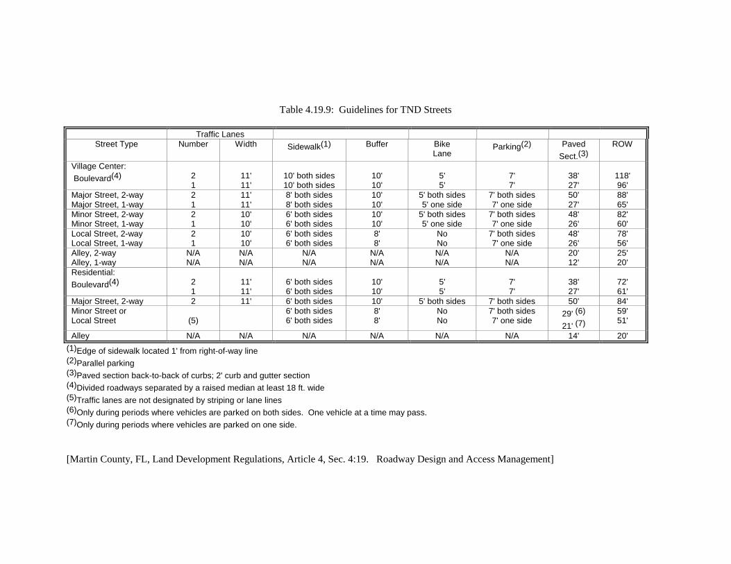
Table 4.19.9: Guidelines for TND Streets
Traffic Lanes Street Type Number Width Sidewalk(1) Buffer Bike
Lane Parking(2) Paved
Sect.(3) ROW
Village Center: Boulevard(4)
2 1
11' 11'
10' both sides 10' both sides
10' 10'
5' 5'
7' 7'
38' 27'
118' 96'
Major Street, 2-way Major Street, 1-way
2 1
11' 11'
8' both sides 8' both sides
10' 10'
5' both sides 5' one side
7' both sides 7' one side
50' 27'
88' 65'
Minor Street, 2-way Minor Street, 1-way
2 1
10' 10'
6' both sides 6' both sides
10' 10'
5' both sides 5' one side
7' both sides 7' one side
48' 26'
82' 60'
Local Street, 2-way Local Street, 1-way
2 1
10' 10'
6' both sides 6' both sides
8' 8'
No No
7' both sides 7' one side
48' 26'
78' 56'
Alley, 2-way Alley, 1-way
N/A N/A
N/A N/A
N/A N/A
N/A N/A
N/A N/A
N/A N/A
20' 12'
25' 20'
Residential: Boulevard(4)
2 1
11' 11'
6' both sides 6' both sides
10' 10'
5' 5'
7' 7'
38' 27'
72' 61'
Major Street, 2-way 2 11' 6' both sides 10' 5' both sides 7' both sides 50' 84' Minor Street or Local Street
(5)
6' both sides 6' both sides
8' 8'
No No
7' both sides 7' one side
29' (6) 21' (7)
59' 51'
Alley N/A N/A N/A N/A N/A N/A 14' 20' (1)Edge of sidewalk located 1' from right-of-way line (2)Parallel parking (3)Paved section back-to-back of curbs; 2' curb and gutter section (4)Divided roadways separated by a raised median at least 18 ft. wide (5)Traffic lanes are not designated by striping or lane lines (6)Only during periods where vehicles are parked on both sides. One vehicle at a time may pass. (7)Only during periods where vehicles are parked on one side.
[Martin County, FL, Land Development Regulations, Article 4, Sec. 4:19. Roadway Design and Access Management]

APPENDIX B: SELECTED EXCERPTS OF THE EUGENE, OREGON CODE
Source: City of Eugene, Oregon. Land Use Regulations, Ordinance Number 20224, May 29, 2001.
The following excerpts from the City of Eugene, Oregon land development code address design criteria for major commercial or multi-use developments, pedestrian circulation, transit improvements, street connectivity standards and exception criteria, and parking. Criteria are also provided relative to review of proposed land division and subdivisions (e.g.”partitions”).
9.2173 Commercial Zone Development Standards - Large Commercial Facilities.
(1) Description and Purpose. The intent of these regulations is to:
(a) Improve the appearance and function of large commercial developments in any commercial zone.
(b) Encourage efficient use of land resources and urban services.
(c) Encourage mixed use.
(d) Support transportation options.
(e) Promote detailed, human-scale site and building design.
(2) Application of Standards. In addition to the standards of EC 9.2170 Commercial Zone Development Standards - General, the standards in this section apply to any new building with 25,000 square feet or more of floor area, 9.2173 Eugene Code 9.2173 and the portion of the development site specifically affected by the new building.
(3) Building Entrances.
(a) All building sides that face an adjacent street shall feature at least one customer entrance.
(b) Where a building faces more than two adjacent streets, excluding those with limited access, this requirement shall apply only to two sides of the building.
(c) Corner entrances, placed at an angle of up to 45 degrees from the primary street, as measured from the street lot line, may be substituted for separate entrances required under subsection (b), above.
(4) Off-Street Parking.
(a) No off-street parking shall be located between the front facade of any building(s) and the primary adjacent street. This standard applies to buildings constructed or completely reconstructed after August 1, 2001.
(b) Individual parking areas may be no larger than 55,000 square feet in size. Separation between individual parking areas may be achieved by placement of internal accessways.

Such accessways used to separate parking areas shall have at least one travel lane, curbs, and sidewalks at least 8 feet in width on both sides of the access way.
(5) Vehicle Connections Between Sites. For development sites that abut an arterial or collector street, at least one internal vehicle accessway connection must be made between the subject development site and adjacent sites zoned for commercial use.
(6) On-Site Pedestrian Circulation. In place of standards set forth in EC 9.6730 Pedestrian Circulation On-Site, the following standards shall apply to large commercial facilities:
(a) A continuous internal pedestrian walkway, no less than 8 feet in width, shall be provided from the public sidewalks or right-of-way to all customer entrances of all buildings on the development site, and to all public sidewalks and paths abutting the development site.
(b) Sidewalks, no less than 8 feet in width, shall be provided along the full length of building walls featuring a customer entrance, and along any wall abutting public parking areas. Such sidewalks shall be located at least 6 feet from the wall of the building to provide planting beds for foundation landscaping, except where features such as arcades or entryways are part of the facade.
(c) Sidewalks, no less than 8 feet in width, shall be provided for direct connection to entrances of all new and existing buildings on the development site to one another, except entrances used for loading and unloading freight. 9.2173 Eugene Code 9.2173
(d) Internal pedestrian walkways provided in conformance with subsection (a) above shall provide weather protection features such as awnings or arcades within 30 feet of all customer entrances.
(e) At least one pedestrian accessway connection, a minimum of 8 feet in width, shall be made to connect the buildings on the subject development site to all adjacent sites either developed or zoned for commercial, office, residential, or institutional use.
(f) All on-site pedestrian walkways located in vehicle use areas shall be distinguished from driving surfaces through the use of durable, low maintenance surface materials such as pavers, bricks, or scored concrete to enhance pedestrian safety and comfort, as well as the attractiveness of the walkways.
(7) Interior Yard Landscaping. Interior yards abutting a lot with a residential zone shall be provided with landscaping that meets the requirements in EC 9.6210(7) Massed Landscape Standard (L-7). The required landscaping may be pierced by pedestrian and vehicular access ways.
(10) Exterior Wall Articulation, Facades, and Ground Floor Windows.
(a) Exterior building walls shall not continue along an uninterrupted plane for more than 100 feet. An uninterrupted plane is a wall that has no variation in exterior surface along its length. Except for building walls facing an alley, ground floor facades 100 feet or greater in length, measured horizontally, shall incorporate wall plane projections or recesses having a depth of at least 3 percent of the length of the facade and extending at least 20 percent of the length of the facade.)
(b) Ground floor facades that face streets adjacent to the development site shall have arcades, collonades, display windows, entry areas, awnings, or other such features along no less than 50 percent of their horizontal length.
(c) Except for building walls facing an alley, ground floor walls shall contain 9.2173 Eugene Code 9.2175 windows (as stated below) at the ground level. The windows may extend a maximum sill height of 4 feet above finished grade to any head height. The portion of window area meeting this standard is from the sill (bottom edge) to the head (top edge) including portions up to 9 feet above the finished grade. Alcoves, entryways, and extruding portions of the wall shall be treated by measuring through such areas as though along the flat wall of a building. Solid walls are prohibited along street frontages. This standard does not apply to parking structures.
1. General Standard. The windows in any walls that require windows shall occupy at least 50 percent of the length and 25 percent of the ground floor wall area. Required window areas shall be either windows that allow views into working areas or lobbies, pedestrian entrances, or display windows. The bottom of the windows shall be no more than 4 feet above the finished grade.
2. Corner Lots. On corner lots, the general ground floor window standard stated in subsection (c) must be met on one street frontage only. On the other street(s), the requirement is ½ of the general standard. The applicant may choose on which street to apply the general standard.
9.2175 Commercial Zone Development Standards - Large Multi-Tenant Commercial Facilities.
(1) Description and Purpose. The intent of these regulations is to assure that the design and layout of large multi-tenant commercial facilities (e.g. shopping centers) facilitates pedestrian safety, comfort, and convenience.
(2) Application of Standards. In addition to the standards in EC 9.2170 Commercial Zone Development Standards - General, and the standards in EC 9.2173 Commercial Zone Development Standards - Large Commercial Facilities the standards in this section apply to all development projects proposing at least 50,000 square feet of floor area within 3 or more new buildings on a development site, and the portion of the development site specifically affected by the new buildings.
(3) On-Site Vehicle Circulation. Site plans for large multi-tenant commercial facilities shall clearly indicate the types of circulation facilities to be built on site. Types to be identified include the following:
(a) Internal Accessways. Accessways are used to provide separation and 9.2175 Eugene Code 9.2180 circulation between individual parking areas on the site. See EC 9.2173(4)(b). Accessways used to provide separation between parking areas shall have at least one travel lane, curbs, and sidewalks (minimum 8' in width) on both sides of the accessway.
(b) Private Drive. Private drives are used to provide general circulation around the site and must include the following elements: two travel lanes, sidewalks (minimum 8' in width) on both side of the streets; street trees with an average spacing of 50'; pedestrian-scale lighting and on-street parking (except in required fire lanes).

(c) Shopping Streets. Shopping streets are part of the general circulation system, are designed to provide a comfortable and pleasant shopping environment for the pedestrian, and may be either public or private streets. Shopping streets must include the following elements: two travel lanes, sidewalks (minimum 12' in width) on both sides of the street; street trees planted within planting strip and with an average spacing of 50', pedestrian-scale lighting; curb extensions at intersections and on-street parking.
(4) Shopping Street Site Layout.
(a) To insure that large multi-tenant centers include pedestrian-oriented areas, the site plan must include a shopping street designed to accommodate and stimulate pedestrian activity.
(b) Shopping streets blocks shall not exceed 400' in length.
(c) Buildings shall occupy at least 80% of the frontage on both sides of the shopping street.
(5) Building Orientation.
(a) All buildings on the site must be oriented to either a public street, a private drive, or a shopping street. The building orientation standard is met when the building is placed within the maximum setback established for the zone. The maximum setback may be exceeded if the area between the building and the street or private drive is landscaped or is an enhanced pedestrian space.
(b) Private drives used to meet building orientation standards must incorporate street design elements described in EC 9.2175(3)(b). When private drives are used, the setback is measured from the back of the sidewalk.
(c) On all buildings that meet the building orientation standard, building entries must be in compliance with EC 9.2173(3)(b).
(6) Pedestrian Amenities and Community Spaces.
(a) Each development site subject to these standards shall contribute to the establishment or enhancement of community and public spaces by providing a space where at least two of the following: patio-seating area, pedestrian plaza with benches, covered playground area, kiosk area, water 9.2180 Eugene Code 9.2400 feature, clock tower or other similar focal feature or amenity. Any such area shall have direct access to the public sidewalk network and be placed in a visible location that is convenient for use as a public gathering area.
(b) The review authority may find compliance with this standard if the proposed pedestrian amenities and community spaces are incorporated as part of the shopping street. Examples include wider sidewalks, special paving, ornamental lighting, planters, public benches and seating walls, and public art.
9.6730 Pedestrian Circulation On-Site.

(1) Purpose of Pedestrian Circulation On-Site. These standards are intended to provide safe and efficient circulation for pedestrians within all developments.
(2) Applicability of Standards. As more specifically provided in this section, the standards in this section apply to any development that creates a new building entrance, but not to a building alteration or change in use.
(a) In any zone, except I-2 and I-3, on-site pedestrian paths shall be constructed in the following cases for institutional, office, commercial and industrial development:
1. Between all new building entrances and all streets adjacent to the development site. On-site pedestrian paths shall be designed and constructed to provide a direct connection to existing public right-of-way and public accessways.
2. To connect any new building entrances on a development site to all other new and existing building entrances on the same development site, except entrances used primarily for loading and unloading freight.
3. Along the exterior walls of new buildings greater than 100 feet in length when the wall of the building is located next to a street, parking lot or when a public entrance or entrances are located on the edge of the building, except in the following cases:
a. When the edge of a building is within 20 feet of a public sidewalk and the building entrance is connected to the public sidewalk by an on-site pedestrian facility, no on-site pedestrian facility on the edge of the building adjacent to the sidewalk is required. 9.6730 Eugene Code 9.6730
b. When the edge of the building is bordered by a perimeter of landscaping which does not exceed 30 feet in width, and an on-site pedestrian facility is constructed at the edge of the landscaping, no on-site pedestrian facility immediately adjacent to the landscaped building edge is required.
4. To connect institutional, office, commercial and industrial uses on the development site to adjacent existing or planned institutional, office, commercial or industrial uses, and to existing or planned transit stops, schools, or neighborhood parks where the addition of on-site pedestrian paths would reduce walking or cycling distance between the uses by 200 feet and by at least 50 percent over other available pedestrian routes.
5. Along any development site, an on-site pedestrian facility connecting the street to the main building(s) shall be provided for every 300 feet of street frontage or for every 8 rows of vehicle parking, or for whichever standard requires the most on-site pedestrian paths.
(b) In industrial developments on I-1 zoned property, on-site pedestrian paths shall be constructed in the following cases:
1. Between the main building entrance and all streets adjacent to the development site. On-site pedestrian paths shall be designed and constructed to provide a direct connection to existing public right-of-way and public accessways.

2. To connect the main building entrance on the development site to adjacent existing or planned office, commercial or industrial uses, and to existing or planned transit stops where the addition of the on-site pedestrian facility would reduce walking or cycling distance between the uses by 200 feet and by at least 50 percent over other available pedestrian routes.
(c) In all zones, on-site pedestrian paths shall be constructed within new multiple-family residential developments with 3 or more units to insure that access is provided:
1. From every unit to all other units within the residential development.
2. From every unit to all laundry, recreational and other community facilities in the residential development.
3. From every building located within 40 feet of a public or private street to the street right-of-way line.
(3) Design of On-Site Pedestrian Facilities. All on-site pedestrian paths provided for the purposes of complying with this land use code shall conform with the following standards:
(a) On-site pedestrian paths shall provide direct access from public ways to building entrances.
(b) On-site pedestrian paths shall be constructed of concrete or a comparable hard surface material.
(c) On-site pedestrian paths shall be raised to standard curb height when adjacent to public and private streets or driveways.
(d) Where necessary for traffic circulation, on-site pedestrian paths may be intersected by driving aisles as long as the crossing is marked with striping or 9.6735 Eugene Code 9.6745 constructed with a contrasting paving material to indicate a pedestrian crossing area.
(e) On-site vehicular and pedestrian circulation shall be designed to minimize vehicular/pedestrian conflicts at driveway crossings within parking lots and at vehicle ingress/egress points.
(f) Pedestrian scale lighting in conformance with the standards in EC 9.6725 Outdoor Lighting Standards shall be provided along pedestrian facilities.
9.6770 Transit Improvements. (1) The location of transit stops shall be based upon the size and trip generation of new
development adjacent to an existing or planned transit corridor. The transit operator shall review site plans and may recommend transit-related facilities be constructed for the following developments:
(a) Residential developments having an average peak hour trip rate of 25 trips or greater.

(b) Commercial and industrial developments other than office developments, 9.6770 Eugene Code 9.6780 having an average peak hour trip rate of 100 trips or greater. Office developments generating 50 or more average peak hour trips.
(c) Institutional uses and public facilities, including churches, hospitals, middle schools, high schools, universities and colleges, public parks (other than neighborhood parks), libraries, post offices, and other institutional and public facilities generating 100 or more average peak hour trips.
9.6810 Block Length. Block length for local streets shall not exceed 600 feet, unless the developer demonstrates that a block length must be greater than 600 feet because of the existence of one or more of the following conditions: (1) Physical conditions preclude a block length 600 feet or less. Such conditions may include,
but are not limited to, topography or the existence of natural resource areas such as wetlands, ponds, streams, channels, rivers, lakes or upland wildlife habitat area, or a resource on the National Wetland Inventory or under protection by state or federal law.
(2) Buildings or other existing development on adjacent lands, including previously
subdivided but vacant lots or parcels, physically preclude a block length 600 feet or less, considering the potential for redevelopment.
(3) An existing public street or streets terminating at the boundary of the development site
have a block length exceeding 600 feet, or are situated such that the extension of the street(s) into the development site would create a block length exceeding 600 feet. In such cases, the block length shall be as close to 600 feet as practicable. Special block requirements related to multiple-family developments are found in section (10) of EC 9.5500 Multiple-Family Standards.
9.6815 Connectivity for Streets.
(1) Purpose and Intent. The street connectivity standards of EC 9.6815(2) Street Connectivity Standards are established to ensure that all of the following are met:
(a) Streets are designed to efficiently and safely accommodate emergency fire and medical service vehicles.
(b) The layout of a street system does not create excessive travel lengths.
(c) The function of a local street is readily apparent to the user through its appearance and design in order to reduce non-local traffic on local residential streets.
(d) Streets are interconnected to reduce travel distance, promote the use of alternative modes, provide for efficient provision of utility and emergency services, and provide for more even dispersal of traffic.
(e) New streets are designed to meet the needs of pedestrians and cyclists and encourage walking and bicycling as transportation modes.

(f) The street circulation pattern provides connections to and from activity centers such as schools, commercial areas, parks, employment centers, and other major attractors.
(g) Street design is responsive to topography and other natural features and avoids or minimizes impacts to water-related resources and wildlife corridors.
(h) Local circulation systems and land development patterns do not detract from the efficiency of adjacent collector streets or arterial streets which are designed to accommodate heavy traffic.
(i) Streets identified as future transit routes should be designed to safely and efficiently accommodate transit vehicles, thus encouraging the use of public transit as a transportation mode.
(j) Where appropriate, the street system and its infrastructure should be utilized as an opportunity to convey and treat storm water runoff. 9.6815 Eugene Code 9.6815
(2) Street Connectivity Standards.
(a) All streets and alleys shall be public unless the developer demonstrates that a public street or alley is not necessary for compliance with this land use code or the street connectivity standards of subparagraphs (b) to (f) of this subsection.
(b) The proposed development shall include street connections in the direction of all existing or planned streets within 1/4 mile of the development site. The proposed development shall also include street connections to any streets that abut, are adjacent to, or terminate at the development site. Secondary access for fire and emergency medical vehicles is required.
(c) The proposed development shall include streets that extend to undeveloped or partially developed land that is adjacent to the development site or that is separated from the development site by a drainage channel, transmission easement, survey gap, or similar property condition. The streets shall be in locations that will not prevent the adjoining property from developing consistent with applicable standards.
(d) The proposed street alignment shall minimize excavation and embankment and avoid impacts to natural resources, including water-related features.
(e) The requirements of subparagraphs (b) and (c) of this subsection do not apply if it is demonstrated that a connection cannot be made because of the existence of one or more of the following conditions:
1. Physical conditions preclude development of the connecting street. Such conditions may include, but are not limited to, topography or likely impact to natural resource areas such as wetlands, ponds, streams, channels, rivers, lakes or upland wildlife habitat area, or a resource on the National Wetland Inventory or under protection by state or federal law.
2. Buildings or other existing development on adjacent lands, including previously subdivided but vacant lots or parcels, physically preclude a connection now or in the future, considering the potential for redevelopment.

(f) In cases where a required street connection would result in the extension of an existing street that is not improved to city standards and the street has an inadequate driving surface, the developer shall construct a temporary barrier at the entrance to the unimproved street section with provision for bicycle, pedestrian, and emergency vehicle access. The barrier shall be removed by the city at the time the existing street is improved to city standards or to an acceptable standard adopted by the public works director. In making a determination of an inadequate driving surface, the public works director shall consider the street rating according to Eugene’s Paving Management System and the anticipated traffic volume.
(g) The standards in this subsection (2) may be adjusted if consistent with the criteria of EC 9.8030(12)(a) of this land use code.
9.6820 Cul-de-Sacs. (1) All streets that terminate shall be designed as a cul-de-sac bulb, except when any of the
following conditions exist:
(a) The street will be extended in the future. 9.6830 Eugene Code 9.6840
(b) Topographic constraints, existing development, or natural features prevent the construction of a bulb.
(c) The street is less than 150 feet long.
(2) If a street qualifies for exception under subsection (1)(a), a temporary easement shall be provided and a turnaround of suitable strength constructed in an alternative location approved by the planning director. Conditions such as signage, restrictive covenants, or maintenance agreements may be required by the planning director to ensure that the turnaround area remains in good repair and available for use as intended.
(3) If a street qualifies for an exception under subsection (1)(b) or (1)(c), a hammerhead
turnaround shall be substituted where possible. (4) There shall be no cul-de-sacs more than 400 feet long from the centerline of the
intersecting street to the radius point of the cul-de-sac bulb. (5) Where needed, the planning director shall require public accessways from a cul-de-sac
longer than 150', measured from the centerline of the intersecting street to the radius point of the cul-de-sac to provide safe, convenient, and direct circulation for pedestrians, bicyclists, and emergency vehicles.
(6) An adjustment may be granted to the maximum cul-de-sac length if consistent with the
criteria for adjustment of EC 9.8030(12)(b) of this land use code.
9.6835 Public Accessways. (1) When necessary to provide safe, convenient and direct access for pedestrians and
bicyclists to and from nearby residential areas, transit stops, neighborhood activity centers, and other commercial and industrial areas, or where required by adopted plans, the city shall

require within the development the dedication to the public and improvement of accessways to connect to cul-de-sacs, or to pass through blocks, provided the city makes findings to demonstrate consistency with constitutional requirements. “Nearby" means uses within 1/4 mile that can reasonably be expected to be used by pedestrians, and uses within 2 miles that can reasonably be expected to be used by bicyclists. Public accessways shall conform to design standards for accessways contained in the “Design Standards for Eugene 9.6840 Eugene Code 9.6860 Streets, Sidewalks, Bikeways and Accessways”.
(2) When necessary to provide connectivity, the city shall require improvements to existing
unimproved public accessways on properties adjacent to the development, provided the city makes findings to demonstrate consistency with constitutional requirements. Said improvements to unimproved public accessways shall connect to the closest public street or developed accessway. Where possible, accessways may also be employed to accommodate the uses included in EC 9.6500 Easements.
9.8030 Adjustment Review - Approval Criteria. The planning director shall approve, conditionally approve, or deny an adjustment review application. Approval or conditional approval shall be based on compliance with the following applicable criteria.
(10) Motor Vehicle Parking and Loading Standards Adjustment. Where this land use code provides that the motor vehicle parking standards may be adjusted, the standards may be adjusted upon finding the applicable corresponding criteria are met.
(a) Number of Required Off-Street Parking Spaces. Adjustments may be made to the required
number of off-street parking space provisions of EC 9.6410 based on the following criteria:
1. The minimum required off-street parking spaces may be reduced by up to 50 percent
when the applicant for a development can demonstrate, in a parking-traffic study prepared by a traffic engineer, that both of the following conditions exist:
a. The use of alternative modes of transportation, including transit, bicycles, and
walking, and/or special characteristics of the customer, client, employee or resident population will reduce expected vehicle use and parking space demand for this development, as compared to standard Institute of Transportation Engineers vehicle trip generation rates and minimum city parking requirements.
b. A Transportation Demand Management (TDM) Program has been approved by the
city that contains strategies for reducing vehicle use and parking demand generated by the development and establishes benchmarks by which the program’s effectiveness will be measured annually.
2. In the case of an existing use proposing to provide a transit stop and related amenities
such as a public plaza, pedestrian sitting areas, transit-supportive development, and additional landscaping, the number of required off-street parking spaces may be reduced by up to 10 percent.

(d) Shared Off-Street Parking. The shared off-street parking space requirements of EC 9.6430 may be adjusted as follows:
1. Joint Use at Different Times. The joint use of required facilities at different times may
be allowed provided all of the following exist: a. The applicant shows there will be no substantial conflict in the principal operating
hours of the buildings or uses for which the joint parking use is proposed. b. The parking facility will be within 1/4 mile or 1,320 feet of buildings or uses it will
serve.
c. The parties involved in the joint parking facility agree to the joint use arrangement in a legal document approved by the city attorney.
d. The legal document is recorded in the office of the Lane County recorder and a copy
filed with the city's Building and Permit Services Division. 2. Joint Use Simultaneously. The simultaneous joint use of required facilities may be
allowed provided all of the following exist:
a. No more than 2 uses under separate ownership or 9.8030 Eugene Code 9.8030 occupancy shall be involved.
b. The uses will occur on the same development site. c. It can be reasonably anticipated that a number of customers or clients will be served
by both uses while on the development site.
(12) Streets, Alleys, and Other Public Way Standards Adjustment. As set out below, specific standards set forth in EC 9.6815 through 9.6830 pertaining to streets may be adjusted if the corresponding criteria are met.
(a) Street Connectivity Standards. As an alternative to compliance with the standards of EC
9.6815(2) Street Connectivity Standards (a)-(d), the applicant may, at his or her expense, provide to the city a local street connection study that demonstrates how the proposed street system meets the intent of street connectivity provisions of this land use code as expressed in EC 9.6815(1), and how undeveloped or partially developed properties within a quarter mile can be adequately served by alternative street layouts. Approval of the street connection study by the city shall constitute an adjustment to the standards of EC 9.6815(2).
(b) Cul-de-Sacs. The limitation of a 400 foot maximum length for a cul-de-sac in EC 9.6820
may be adjusted if all of the following conditions exist:
1. The physical shape of the property prevents alternative development patterns and there are no practical alternative street layouts available that would meet street connectivity.
2. The physical conditions of the property preclude the ability to achieve the density
permitted according to the zoning of the property with a cul-de-sac of only 400 feet.

Such conditions may 9.8030 Eugene Code 9.8030 include, but are not limited to, topography or the existence of natural resource areas such as wetlands, ponds, streams, channels, rivers, lakes or upland wildlife habitat area, or a resource on the National Wetland Inventory or under protection by state or federal law.
9.8215 Partition, Tentative Plan Approval Criteria- General. The planning director shall approve, approve with conditions, or deny a partition, with findings and conclusions. Approval, or approval with conditions, shall be based on compliance with the following criteria: 9.8215 Eugene Code 9.8215
(2) The proposed partition will not create a new nonconforming situation.
(3) Partitions abutting collector and arterial streets comply with access management guidelines of the agency having jurisdiction over the street.
(4) If the provisions of EC 9.8215(1) require a public street, or if the applicant proposes the creation of a public street, all of the following criteria also apply:
(a) The proposal will not impede the future best use of the remainder of the property under the same ownership or adversely affect the development of the remainder or any adjoining land or access thereto.
(c) The proposed partition provides direct bicycle and pedestrian access to nearby and adjacent residential areas, transit stops, neighborhood activity centers, commercial areas, and industrial areas, and provides safe, convenient and direct transit circulation, provided the city makes findings to demonstrate consistency with constitutional requirements. “Nearby” means uses within 1/4 mile that can reasonably be expected to be used by pedestrians, and uses within 2 miles that can be reasonably expected to be used by bicyclists.
(6) If the partition results in a parcel greater than 13,500 square feet in size, the application shall indicate the location of parcel lines and other details of layout that show future division may be made without violating the requirements of this 9.8215 Eugene Code 9.8220 land use code and without interfering with the orderly extension of adjacent streets, bicycle paths, and accessways. If the planning director deems it necessary for the purpose of future land division, any restriction of buildings within future street, bicycle path, and accessway locations shall be made a matter of record in the tentative plan approval. (Section 9.8215 amended by Ordinance No. 20235, enacted October 8, 2001, effective October 10, 2001.)
9.8220 Partition, Tentative Plan Approval Criteria- Needed Housing. The planning director shall approve, conditionally approve, or deny the partition application. Unless the applicant elects to use the general criteria contained in EC 9.8215 Partition, Tentative Plan Approval Criteria- General, where the applicant proposes needed housing, as defined by the State statutes, the planning director shall approve or approve with conditions a partition based on compliance with the following criteria:
(3) The proposed partition will not cause any existing improvements on proposed lots to be inconsistent with applicable standards in this land use code.

(4) Partitions abutting collector and arterial streets comply with access management guidelines of the agency having jurisdiction over the street.
(5) If the provisions of EC 9.8220(1) require a public street, or if the applicant proposes the creation of a public street, the following criteria also apply:
(a) The proposed land uses and densities within the partition are consistent with the land use designation(s) shown on the Metro Plan Land Use Diagram, as refined in any applicable refinement plan.
(b) Provision of pedestrian, bicycle and transit circulation, including related facilities, as needed among buildings and related uses on the development site, as well as to adjacent and nearby residential areas, transit stops, 9.8220 Eugene Code 9.8235 neighborhood activity centers, office parks, and industrial parks, provided the city makes findings to demonstrate consistency with constitutional requirements. “Nearby” means uses within 1/4 mile that can reasonably be expected to be used by pedestrians, and uses within 2 miles that can reasonably be expected to be used by bicyclists.
(c) The street layout of the proposed partition shall disperse motor vehicle traffic onto more than one public local street when the sum of proposed partition parcels and the existing lots utilizing a local street as the single means of ingress and egress exceeds 19.
(7) If the partition results in a parcel greater than 13,500 square feet in size, the application shall indicate the location of parcel lines and other details of layout that show future division may be made without violating the requirements of this land use code and without interfering with the orderly extension of adjacent streets, bicycle paths, and accessways. If the planning director deems it necessary for the purpose of future land division, any restriction of buildings within future street, bicycle path, and accessway locations shall be made a matter of record in the tentative plan approval. (Section 9.8220 amended by Ordinance No. 20235, enacted October 8, 2001, effective October 10, 2001.)

APPENDIX C: SAMPLE COMPREHENSIVE PLAN AMENDMENTS
City of Destin, Florida City of Destin Comprehensive Plan, Transportation Element. 2001.
Objective 2-1.3: PLAN AND DESIGN MULTIMODAL TRANSPORTATION SYSTEM. The City shall plan and design a multimodal transportation system that promotes the increased use of alternative modes of transport such as bicycle, pedestrian and public transit, by providing a safe, attractive and convenient environment through implementation of pedestrian and transit friendly urban design, land use and traffic circulation strategies. Such traffic circulation system shall support and be consistent with the existing and desired development patterns as characterized by the Future Land Uses shown on the Future Land Use Maps (Map No.___, ___ and ___) and by implementing the following measurable policies.
Policy 2-1.3.1: Bicycle and Pedestrian Facilities. The City shall develop a bicycle and pedestrian facilities long-range plan by 2005 providing or requiring the provision of bicycle and pedestrian facilities to link residential areas with recreational and commercial areas in a safe, comfortable, and convenient manner. The plan shall consider previous planning efforts described in the Pathways Master Plan, the Destin Harbor Area Master Plan, the Destin Town Center Redevelopment Area Plan and the Destin’s Vision 2000 Plan. Implementing this plan shall be made part of the Capital Improvement Element /Capital Improvement Plan.
The City shall evaluate the potential of implementing locally oriented transit service by identifying: desired transit corridors, employment centers, high density residential areas and populations to be served, community facilities, activity centers and intermodal transfer points. The City shall evaluate each potential transit corridor for its technical feasibility and estimate initial capital outlay, operational and maintenance costs.
Policy 2-1.3.4: Efficient On-Site Traffic Circulation. All developments, including but not limited to, planned unit developments, commercial subdivisions, shopping centers, multi-family residential projects shall be required to provide safe and convenient on-site traffic flow, sufficient vehicular parking, and a safe, convenient, and attractive pedestrian environment, by integrating the policies of this chapter (element).
Policy 2-1.3.5: Coordinate Multimodal Plans with Other City and County Plans. The City shall coordinate all multimodal transportation planning efforts with City and County plans for the park system, schools, and other public places.
Objective 2-1.4: MULTIMODAL TRANSPORTATION DISTRICT ESTABLISHED. The City hereby designates …as a Multimodal Transportation District (MTD) pursuant to Florida Statutes - Chapter 163.3180(15)(a) and as designated on Map X, Multimodal District Boundaries of the Transportation Element and Map __ of the Future Land Use Element. A MTD allows for a creative approach to concurrency by establishing performance measures for non-auto travel modes. In this district priority is placed on establishing a safe, convenient, and attractive pedestrian environment. Good pedestrian access and convenient connections to future transit service shall be promoted/required in this district.
Policy 2-1.4.1: Performance Measures for Multimodal System. The City shall establish multimodal performance measures for pedestrian and bicycle travel modes to

help evaluate the concurrency status of transportation facilities in the MTD. In doing so, the City will review the measures currently being developed for the Florida DOT and the MPO Congestion Management System (CMS).
Policy 2-1.4.2: Design Guidelines for Pedestrian and Transit Facilities. The City shall develop new pedestrian and transit friendly urban design guidelines to direct new development and redevelopment activities in the MTD. These urban design guidelines shall be adopted as a component of the City’s Land Development Code.
Policy 2-1.4.3: Road Impact Fee Credits to Promote MTD Improvements. The City shall consider revising its existing road impact fee ordinance to provide credits to future development and redevelop activity in the MTD that incorporate the pedestrian and transit friendly urban design features adopted pursuant with Policy 2.A.4.2 above.
Policy 2-1.4.5: Level of Service Standards for Multimodal Transportation System. By 2003, the City shall adopt multimodal level-of-service standards to evaluate the existing non-auto transportation system and determine current levels-of-service using professionally accepted multimodal performance methodologies.
Policy 2-1.4.6: Schedule to Incorporate Multimodal Transportation System into the Comprehensive Plan. By 2003, the Multimodal Transportation System Plan (MTSP) shall be incorporated as a component of the Transportation Element. The MTSP shall identify pedestrian, bicycle and transit system deficiencies in addition to identifying transportation improvement projects, traffic calming measures and a parking plan to correct those deficiencies. These improvement projects shall be prioritized and programmed in the Capital Facilities Element so that these non-auto capacity improvements can be considered available for the purpose of concurrency assessment.
Policy 2-1.4.7: Bicycle Parking Standards. By 2003, the vehicle parking standards contained in the Land Development Code shall be revised to include minimum parking standards for bicycles.

REFERENCES
1 Gainesville Metropolitan Transportation Planning Organization, Year 2020 Transportation Needs Plan, pp. 3-3 to 3-5.
2 The concurrency laws of the State of Florida permit new development and redevelopment to occur only where the infrastructure of a jurisdiction, including transportation infrastructure, will support such development as determined by a level of service analysis. A Transportation Concurrency Exception Area (TCEA) allows for an exception to transportation concurrency requirements in designated areas, provided there is a community commitment to pursue an alternative transportation system and urban forms that will reduce single occupant vehicle trips and automobile use. To qualify for TCEA designation, an area must meet the following criteria: no more than 10% undeveloped land, five dwelling units per acre for residential areas, and a floor-area-ratio (FAR) of 1.0 for nonresidential land uses. This type of district is primarily intended to promote development of public transportation.
3 Glatting Jackson Kercher Anglin Lopez Rinehart, Inc. West University Avenue Corridor Traffic Study – Final Report, 1999.
4 Interview with Ralph Hillard, City of Gainesville, Florida, December 2001.
5 City of Gainesville Planning Division, Analysis of Major Issues Related to the Comprehensive Plan, Achievement of Goals and Identification of Actions to Address Major Issues, undated, http://www.state.fl.us/gvl/Government/Documents/MajorIssues.pdf
6 PIARC Technical Committee on Interurban Roads and Roads in Urban Areas. “Through Traffic in Small Towns.” 1991. pg. 8-10 and 13.
7 R. Ewing, Pedestrian and Transit-Friendly Design, prepared for the Florida Department of Transportation, March 1996.
8 Pedestrian and Transit-Friendly Design, op cit.
9 S/K Transportation Consultants, Access Management, Location and Design, Participant Notes for NHI Course No. 133078, National Highway Institute, Federal Highway Administration, April 1998, revised April 2000.


![Monitoria multimodal cerebral multimodal monitoring[2]](https://static.fdocuments.net/doc/165x107/552957004a79599a158b46fd/monitoria-multimodal-cerebral-multimodal-monitoring2.jpg)