IMPLEMENTATION REPORT AND RESETTLEMENT ACTION...
189
1 KERALA STATE TRANSPORT PROJECT - II PUBLIC WORKS DEPARTMENT GOVERNMENT OF KERALA IMPLEMENTATION REPORT AND RESETTLEMENT ACTION PLAN FINAL REPORT DECEMBER 2012
Transcript of IMPLEMENTATION REPORT AND RESETTLEMENT ACTION...
1
KERALA STATE TRANSPORT PROJECT - II PUBLIC WORKS DEPARTMENT
GOVERNMENT OF KERALA
IMPLEMENTATION REPORT
AND
RESETTLEMENT ACTION PLAN
FINAL REPORT
DECEMBER 2012
2
CONTENTS
Abbreviations … i
Executive Summary … ii
Chapter I Introduction … 1
Chapter II R&R Policy … 9
Chapter III Institutional Arrangements – Roles and Responsibility 18
Chapter IV Implementation Process and Progress 28
Chapter V Action Plan for completion of RAP Implementation 45
Chapter VI Conclusion … 48
Annexures … 51
Annexure‐1 Land Schedule of Link 4 Chengannur‐Ettumanoor Road
Annexure‐2 Land Schedule of Link 5 Ettumanoor‐Muvattupuzha Road
Annexure‐3 Land Schedule of Link 68 Pilathara‐Pappinissery Road
Annexure‐4 Land Schedule of Link 69 Kasaragor‐Kanhangad Road
Annexure‐5 Land Schedule of Link 74 Thalassery‐Valavupara Road
Annexure‐6 Land Schedule of Link 84.1 Punalur‐Ponkunnam Road
Annexure‐7 Land Schedule of Link 84.2 Ponkunnam‐Thodupuzha Road
Annexure‐8 Photographs of displaced and resettled structures
3
Abbreviations
AP Affected Person BPL Below Poverty Line COI Corridor of Impact CPR Common Property Resources DLPC District Level Purchase Committee EP Entitled Person ESC Environmental and Social Cell GOK Government of Kerala GRC Grievance Redressal Committee IRC Indian Roads Congress Km Kilometer KSTP Kerala State Transport Project MDR Major District Road NGO Non‐Government Organization NH National Highway NTH Non‐title holder NTHs Non‐title holder shopkeeper NV Non‐Vulnerable OD Operational Directive ODR Other District Roads OP Operational Policy PAP Project Affected Person PAF Project Affected Family PCC Project Coordination Consultant PDP Project Displaced Person PDF Project Displaced Family PIU Project Implementation Unit PWD Public Works Department R&R Resettlement and Rehabilitation RAP Resettlement Action Plan RoW Right of Way SC Scheduled Caste SLEC State Level Empowered Committee SOS Strategic Option Study Sq m. Square meter ST Scheduled Tribe TH Title holder WB World Bank
4
CHAPTER – I
INTRODUCTION
5
1.1 Prologue
Government of Kerala (GoK) launched a comprehensive fiscal reform in 2001 to bring its finances under control to reverse the trend of deteriorating state finances. In this context, GoK published a white paper on the state’s finances bringing to the public attention, the unsustainable trends in the state’s finances and the need to take urgent corrective action. The medium term fiscal reform programme submitted by GoK to Government of India highlighted the fact that past state expenditure policies have neglected physical infrastructure in the state’s expenditure priorities, thereby lowering economic performance below its potential. The report emphasized the need to correct this policy weakness and identified road sector as the key area thereby proposing removal of traffic bottlenecks to promote economic growth.
The State has one of the most developed and congested road networks in the country with 1550 km of National Highways (NH), 3330 km of State Highways (SH), 11320 km of Major District Roads (MDR), 3810 km of Other District Roads (ODR) and 3346 km of Village Roads (VR). The rest of the total network of 119,218 km includes roads managed by forest, irrigation and also by the three-tier Panchayati Raj Institutions. From 1992-97, the length of the State road network in the State has grown by about 11.50% and PWD road by 7.93% while its paved portion has increased from 66% to 91%. During the same period, most of the expansion in the State road network has occurred on the low capacity Village Road Network, while State Motor Vehicle registrations have increased by about 14% per year and traffic by about the same amount. Because of high vehicle registration growth in Kerala, motor vehicles per every 100 sq.km are 5000. Although the successive five year plans the State Government provided funds for construction and road maintenance of networks in the country, the required allocations to the road sector could not be provided by the State, leaving a gap between the requirement of funds for construction and maintenance of road network and the actual allocation of funds. As a result, the quality of road maintenance suffered. Therefore the GoK undertook several initiatives such as strategic options study and the formulation of Road Development Policy to promote a sustainable road network providing connection to all cities, towns and villages and allowing safe and efficient travel between them. Kerala State Transport Project (KSTP) is the first comprehensive project which addresses 1) the network deficiencies and improving road sector financing 2) enhancing institutional capacities 3) reducing accident rates and mitigating environmental and social impacts.
The KSTP was designed to upgrade 581 km and cover 1000 km under maintenance in
two Phases. However, due to several reasons including delay in land acquisition, only 254 km of Phase I road was upgraded and maintenance works for 1180 km were carried out from June 2002 and December 2009. Even though civil works on remaining 327 km for upgradation could not be undertaken, land acquisition and Resettlement and Rehabilitation of affected people continued. As a result, the preparation phase of KSTP II coincides with the implementation of Resettlement Action Plan for Phase II roads (Addendum I). Therefore, it is appropriate to prepare
6
Implementation Progress Report and action plan to implement the balance activities along 7 links and link 41&47.
1.2 Urban and Rural Areas A village in Kerala has little resemblance to the characteristics of a typical Indian village.
As development in Kerala is along the road, almost all villages are urbanized and are not isolated patches of habitation. As a result, the urban - rural divide in Kerala, is very thin. The official divide for the urban area (part of a city, municipality or town) and rural area in the census is based on the category and boundary of the Local Self Government (LSG) such as Corporation, Municipality and Grama Panchayat.
1.3 Special Features of KSTP
Kerala State Transport Project is not just a road project but a project of excellence with wide implication and the following special features.
1.3.1 Capacity Expansion for Primary Road Networking The project had provisions for widening and upgrading of state highways and periodic
heavy maintenance of major district roads to comply with the Indian Road Congress norms. Strategies to increase the capacity included controlling encroachments and providing footpaths wherever pedestrian traffic is high.
1.3.2 Strengthening Capacity of Road Sector Institutions
The project’s second component has its focus on reforming Public Works Department (PWD) of Kerala and enhancing its institutional capacity to efficiently manage and develop the agency to meet the demands of increasing infrastructure requirements. This includes restructuring of PWD and its existing service delivery functions, training engineers and administrators of the department in the modern project management techniques, quality control and use of modern technical aids and thus upgrades the PWD’s capacity in project design and supervision of construction and maintenance operations. Participation of private sector consulting firms and contractors in the design, construction and maintenance of the state’s roads and promotion of joint venture among international and local contractors are the methodology advocated to usher in the technological and managerial revolution in infrastructure development through exposure and training for capacity building.
1.3.3 Introducing Environmental and Social Impact Monitoring Whereas the economic benefits of road development are well established as reduced
travel time, lower transport costs, increased access to jobs, markets, education and health services, there is also the likelihood of negative environmental and social impacts if appropriate management systems are not adopted during the design, construction and operation stages of road development. KSTP I and II encourage adoption of environmentally and socially sound
7
management practices to mainstream environmental and social concerns in highway projects including impact monitoring.
1.3.4 Improving Road Maintenance Management
The project also seeks to develop an effective road maintenance management system in PWD and thereby reduce the maintenance of backlog for high priority roads by implementing road rehabilitation component. It is intended to improve PWD’s maintenance planning capability and budget procedures. This is to be achieved through road maintenance management study, traffic and road user surveys throughout the state and by establishing modern geographical information system (GIS) based road information and maintenance management system (RIMMS), which is meant to lead to multi-year maintenance plans prioritized by economic criteria.
1.3.5 Improving Road Safety and Reducing Accident Risks
Road accident rate in Kerala is very high and reducing traffic accidents on roads is another objective of the project, which forms a major component. Therefore the project included measures to address road safety through immediate and long term plans such as road safety audits, identification and treatment of black spots, improving pavement conditions and providing traffic signs and road markings, improving the system of accident recording and analysis, strengthening traffic law enforcement, training road safety personnel, greater road safety awareness and interagency road safety coordination.
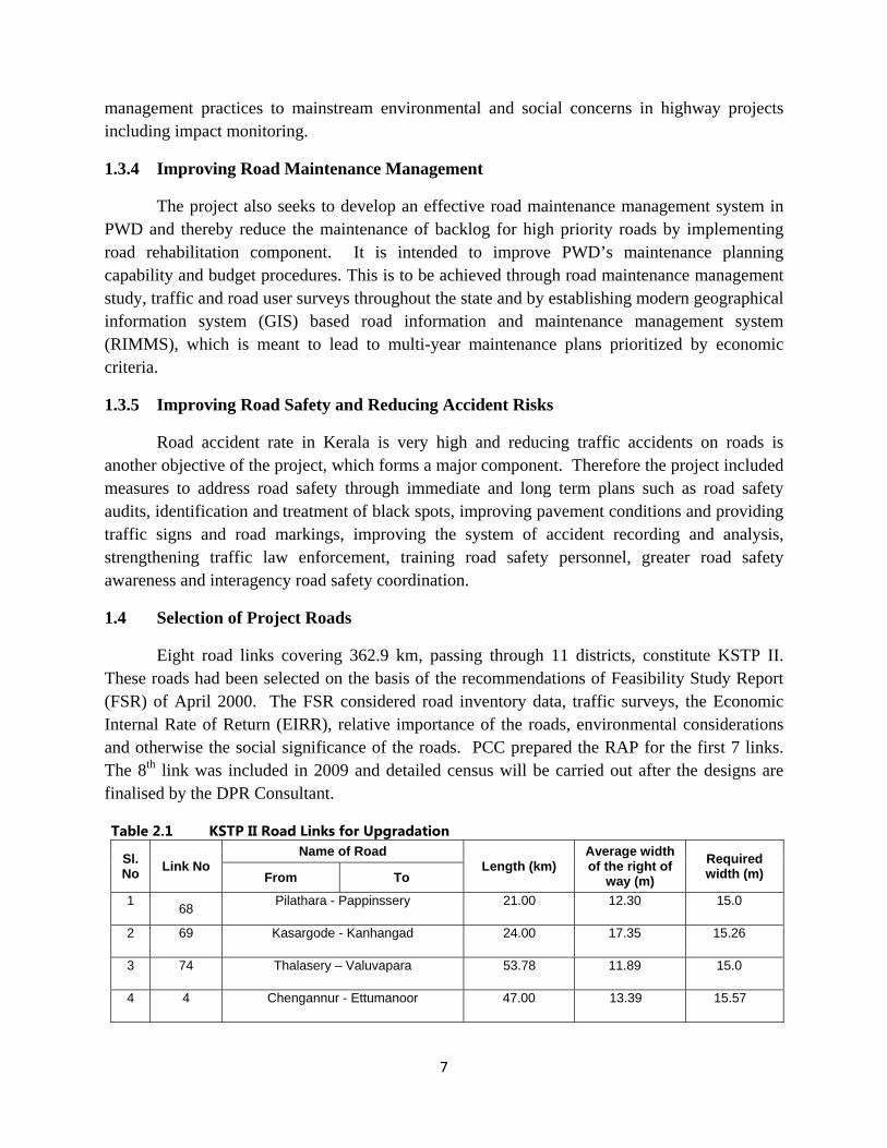
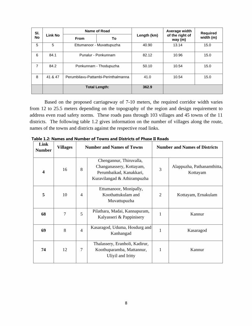
1.4 Selection of Project Roads
Eight road links covering 362.9 km, passing through 11 districts, constitute KSTP II. These roads had been selected on the basis of the recommendations of Feasibility Study Report (FSR) of April 2000. The FSR considered road inventory data, traffic surveys, the Economic Internal Rate of Return (EIRR), relative importance of the roads, environmental considerations and otherwise the social significance of the roads. PCC prepared the RAP for the first 7 links. The 8th link was included in 2009 and detailed census will be carried out after the designs are finalised by the DPR Consultant.
Table 2.1 KSTP II Road Links for Upgradation
Sl. No Link No
Name of Road Length (km)
Average width of the right of
way (m) Required width (m) From To
1 68 Pilathara - Pappinssery 21.00 12.30 15.0
2 69 Kasargode - Kanhangad 24.00 17.35 15.26
3 74 Thalasery – Valuvapara 53.78 11.89 15.0
4 4 Chengannur - Ettumanoor 47.00 13.39 15.57
8
Sl. No Link No
Name of Road Length (km)
Average width of the right of
way (m) Required width (m) From To
5 5 Ettumanoor - Muvattupuzha 40.90 13.14 15.0
6 84.1 Punalur - Ponkunnam 82.12 10.96 15.0
7 84.2 Ponkunnam - Thodupuzha 50.10 10.54 15.0
8 41 & 47 Perumbilavu-Pattambi-Perinthalmanna 41.0 10.54 15.0
Total Length: 362.9
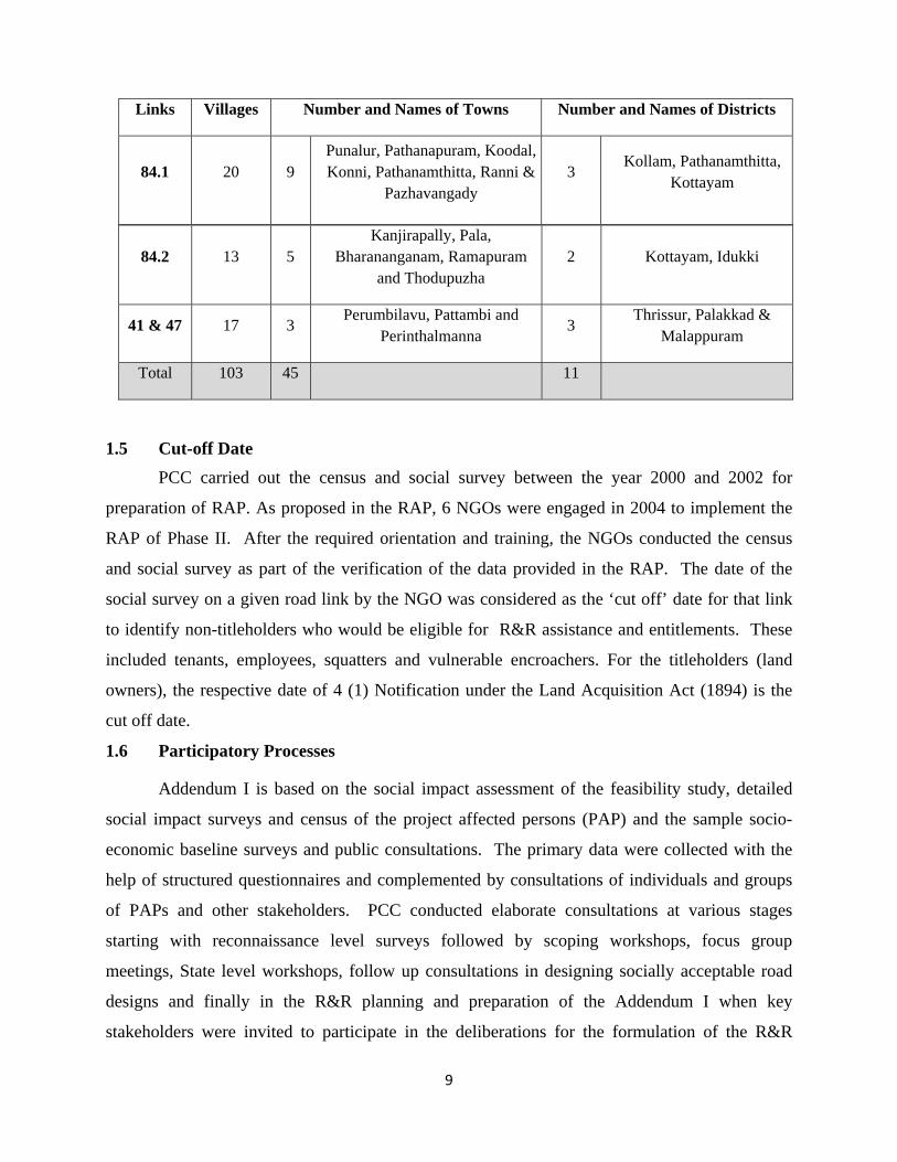
Based on the proposed carriageway of 7-10 meters, the required corridor width varies from 12 to 25.5 meters depending on the topography of the region and design requirement to address even road safety norms. These roads pass through 103 villages and 45 towns of the 11 districts. The following table 1.2 gives information on the number of villages along the route, names of the towns and districts against the respective road links.
Table 1.2: Names and Number of Towns and Districts of Phase II Roads Link
Number Villages Number and Names of Towns Number and Names of Districts
4 16 8
Chengannur, Thiruvalla, Changanassery, Kottayam, Perumbaikad, Kanakkari,
Kuravilangad & Athirampuzha
3 Alappuzha, Pathanamthitta,
Kottayam
5 10 4 Ettumanoor, Monipally,
Koothattukulam and Muvattupuzha
2 Kottayam, Ernakulam
68 7 5 Pilathara, Madai, Kannapuram,
Kalyasseri & Pappinisery 1 Kannur
69 8 4 Kasaragod, Uduma, Hosdurg and
Kanhangad 1 Kasaragod
74 12 7 Thalassery, Eranholi, Kadirur, Koothuparamba, Mattannur,
Uliyil and Iritty 1 Kannur
9
Links Villages Number and Names of Towns Number and Names of Districts
84.1 20 9 Punalur, Pathanapuram, Koodal, Konni, Pathanamthitta, Ranni &
Pazhavangady 3
Kollam, Pathanamthitta, Kottayam
1.5 Cut-off Date PCC carried out the census and social survey between the year 2000 and 2002 for
preparation of RAP. As proposed in the RAP, 6 NGOs were engaged in 2004 to implement the
RAP of Phase II. After the required orientation and training, the NGOs conducted the census
and social survey as part of the verification of the data provided in the RAP. The date of the
social survey on a given road link by the NGO was considered as the ‘cut off’ date for that link
to identify non-titleholders who would be eligible for R&R assistance and entitlements. These
included tenants, employees, squatters and vulnerable encroachers. For the titleholders (land
owners), the respective date of 4 (1) Notification under the Land Acquisition Act (1894) is the
cut off date.
1.6 Participatory Processes
Addendum I is based on the social impact assessment of the feasibility study, detailed
social impact surveys and census of the project affected persons (PAP) and the sample socio-
economic baseline surveys and public consultations. The primary data were collected with the
help of structured questionnaires and complemented by consultations of individuals and groups
of PAPs and other stakeholders. PCC conducted elaborate consultations at various stages
starting with reconnaissance level surveys followed by scoping workshops, focus group
meetings, State level workshops, follow up consultations in designing socially acceptable road
designs and finally in the R&R planning and preparation of the Addendum I when key
stakeholders were invited to participate in the deliberations for the formulation of the R&R
84.2 13 5 Kanjirapally, Pala,
Bharananganam, Ramapuram and Thodupuzha
2 Kottayam, Idukki
41 & 47 17 3 Perumbilavu, Pattambi and
Perinthalmanna 3
Thrissur, Palakkad & Malappuram
Total 103 45 11
10
plans. These included the consultations with the Panchayat/Municipal Council, Project affected
persons, local leaders and elected representatives and people who are interested in the
development of the state. The consultations have influenced the engineering design parameters to
a large extent and have helped to minimise the negative social impacts. The social impact
surveyors interviewed the family members/ owners namely, residential, commercial, agricultural
and other categories of properties that were shown as affected in the preliminary engineering
design. While each person in a given commercial building was enlisted as a “family” the
number of families in the residential building was based on their sociological nuclear family for
the purpose of entitlement.
1.7 Impact Minimizing Exercise
As private land acquisition is inevitable for the project, a number of measures had been
taken to minimise land take and the displacement of people. During project preparation,
emphasis was on minimising the impacts within the limitations of technical feasibility and cost
effectiveness. The options considered for minimising negative social impacts included design
considerations such as accommodating footpaths over drains to minimise the negative social
impact with regard to both land required and road safety. Junction designs will ensure smooth
traffic flow and safe driving, but care has been taken not to acquire any unnecessary extra land.
Inclusion of bypasses reduced impact on buildings, thus minimising displacement of people.
Public consultations and representations of aggrieved people and analysis of alternatives led to
the selection of three bypasses to deviate from the congested Thiruvalla town on Link 4
(Chengannur-Ettumanoor Road), Pala and Thodupuzha towns on Link 84.2 Ponkunnam-
Thodupuzha Road.
1.8 Income Restoration
Public roadsides are the main focus areas for various types of commercial transactions. A
good number of traders and employees carrying out their trade on the roadsides were affected by
the project. People losing their commercial units and employment therein are economically
displaced persons and are equivalent to those displaced from their properties and residences. In
accordance with the R&R Principles and Policy with entitlement matrix, KSTP provided
transitional allowance to commercial units’ owners for six months as income restoration
measures. The employees received assistance equal to three month’s lost income while squatters
and the agricultural families received transitional allowance for six months. In addition, the wage
11
employees, agricultural families and squatters were given the option for training to upgrade their
skills for better employment. The vulnerable groups were eligible for an additional economic
rehabilitation support as grant to stabilise their earning capacity.
12
CHAPTER II
RESETTLEMENT AND
REHABILITATION POLICY
13
2.0 Introduction
In the ongoing discourse on development and the search for a model of sustainable
development, displacement has become a crucial concern. The basic assumption is that
development projects require land acquisition which results in the loss of assets, impairment of
livelihoods, or the physical relocation of individuals, households or community. In order to
mitigate adverse effects, compensate losses, and provide development benefits to persons and
communities affected by an investment project, NGOs and bilateral funding agencies advocated
adoption and implementation of resettlement and rehabilitation policy by the implementing
agencies of development projects. The Public Works Department of Kerala anticipating the
negative impacts within the corridor of impact engaged experts to prepare an R&R Policy
document for the implementation of Kerala State Transport Project in accordance with the
principles laid down in the World Bank’s OD 4.30 on Involuntary Resettlement (During the
course of implementation the World Bank’s OD was replaced with Operational Policy 4.12 on
Involuntary Resettlement) the Kerala State Government approved this policy document, vide
Government Order No. GO (MS) 64/2000, dated 09.10.2000.
2.1 Principles of the Policy
The basic principles for addressing the adverse effects of involuntary resettlement
associated with development projects are:
• Involuntary resettlement should be avoided.
• Where involuntary resettlement is unavoidable, all people affected by it should be
compensated fully and fairly for lost assets.
• Involuntary resettlement should be conceived as an opportunity for improving the
livelihoods of the affected people and undertaken accordingly.
• All people affected by involuntary resettlement should be consulted and involved in
resettlement planning to ensure that the mitigation of adverse effects as well as the
benefits of resettlement are appropriate and sustainable.
2.2 Broad Legal Framework
The R&R policy of the project provides for a comprehensive package of compensation
and assistance to entitled persons, families and groups suffering losses as a result of the project.
It provides mitigating measures for:
14
i) Loss of assets, including land , house or work place
ii) Loss of livelihood or income opportunities; and
iii) Collective impacts on groups, such as loss of community assets, common property
resources and others.
iv) Even in cases where no compensation for land is possible, as in the case of encroachers
and squatters who are illegal occupants of land, the project will offer compensation and
for physical structures, relocation and rehabilitation.
v) The implementation of the administration of compensation will be based on specific
provisions as agreed in the Addendum I
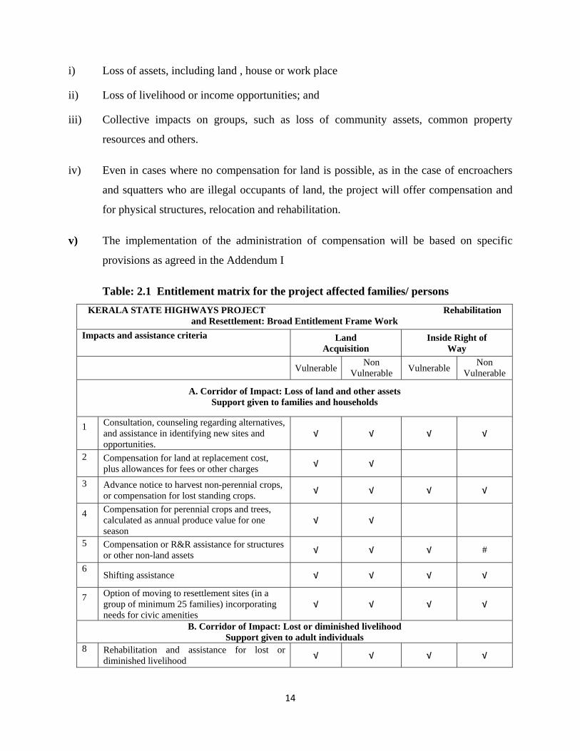
Table: 2.1 Entitlement matrix for the project affected families/ persons KERALA STATE HIGHWAYS PROJECT Rehabilitation
and Resettlement: Broad Entitlement Frame Work Impacts and assistance criteria Land
Acquisition Inside Right of
Way Vulnerable Non
Vulnerable Vulnerable Non Vulnerable
A. Corridor of Impact: Loss of land and other assets Support given to families and households
1 Consultation, counseling regarding alternatives, and assistance in identifying new sites and opportunities.
√ √ √ √
2 Compensation for land at replacement cost, plus allowances for fees or other charges √ √
3 Advance notice to harvest non-perennial crops, or compensation for lost standing crops. √ √ √ √
4 Compensation for perennial crops and trees, calculated as annual produce value for one season
√ √
5 Compensation or R&R assistance for structures or other non-land assets √ √ √ #
6 Shifting assistance √ √ √ √
7 Option of moving to resettlement sites (in a group of minimum 25 families) incorporating needs for civic amenities
√ √ √ √
B. Corridor of Impact: Lost or diminished livelihood Support given to adult individuals
8 Rehabilitation and assistance for lost or diminished livelihood √ √ √ √
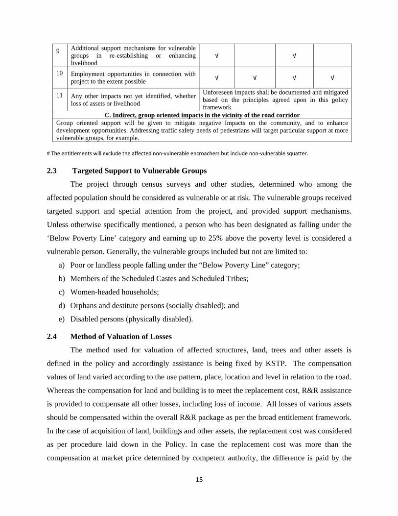
15
9 Additional support mechanisms for vulnerable groups in re-establishing or enhancing livelihood
√ √
10 Employment opportunities in connection with project to the extent possible √ √ √ √
11 Any other impacts not yet identified, whether loss of assets or livelihood
Unforeseen impacts shall be documented and mitigated based on the principles agreed upon in this policy framework
C. Indirect, group oriented impacts in the vicinity of the road corridor Group oriented support will be given to mitigate negative Impacts on the community, and to enhance development opportunities. Addressing traffic safety needs of pedestrians will target particular support at more vulnerable groups, for example.
# The entitlements will exclude the affected non‐vulnerable encroachers but include non‐vulnerable squatter.
2.3 Targeted Support to Vulnerable Groups
The project through census surveys and other studies, determined who among the
affected population should be considered as vulnerable or at risk. The vulnerable groups received
targeted support and special attention from the project, and provided support mechanisms.
Unless otherwise specifically mentioned, a person who has been designated as falling under the
‘Below Poverty Line’ category and earning up to 25% above the poverty level is considered a
vulnerable person. Generally, the vulnerable groups included but not are limited to:
a) Poor or landless people falling under the “Below Poverty Line” category;
b) Members of the Scheduled Castes and Scheduled Tribes;
c) Women-headed households;
d) Orphans and destitute persons (socially disabled); and
e) Disabled persons (physically disabled).
2.4 Method of Valuation of Losses
The method used for valuation of affected structures, land, trees and other assets is
defined in the policy and accordingly assistance is being fixed by KSTP. The compensation
values of land varied according to the use pattern, place, location and level in relation to the road.
Whereas the compensation for land and building is to meet the replacement cost, R&R assistance
is provided to compensate all other losses, including loss of income. All losses of various assets
should be compensated within the overall R&R package as per the broad entitlement framework.
In the case of acquisition of land, buildings and other assets, the replacement cost was considered
as per procedure laid down in the Policy. In case the replacement cost was more than the
compensation at market price determined by competent authority, the difference is paid by the
16
project in the form of assistance. However, the entitlement of compensation and assistance will
be extended to only those PAPs who are so identified on or prior to the cutoff date. Claims
regarding R&R assistance were dealt by the Grievance Redressal Committee.
2.5 Evolution of Resettlement and Rehabilitation Policy
KSTP being the first project to implement Resettlement and Rehabilitation Policy in
Kerala, PAPs and other stakeholders including the general public keenly watched every process
critically and appreciated the best efforts, principles and practices. Mass media provided good
coverage about this new initiative of the Government and pointed out the limitations particularly
of the assistances opening the flood gates of debates and discourses. Soon the media exposed the
sad plight of persons and families affected by other development projects in comparison with
KSTP and started the forum for discussion. Opinion leaders, elected representatives and NGOs
advised the Government for replication of the R&R package of KSTP for other development
projects.
2.5.1 R&R Policy of Fast Tack Projects
Responding positively, GoK in November 2004 adopted R&R Policy of KSTP for all
Fast Track Projects (FTP), vide GO (MS) No.331/2004, dated 05.11.2004. Approval of the
Council of Ministers was the pre-condition to confer the status of FTP to any project. Besides
KSTP the other FTPs were, 1) Doubling/ Gauge Conversion of Railway lines 2) Four-laning of
National Highways 3) Vallarpadam Container Terminal Rail and Road Connectivity 4)
Development of International Airports of Thiruvananthapuram and Kozhikode.
2.5.2 Revision of R&R Assistance
In 2007 GoK cleared the proposal for acquisition of land for Kannur Airport, a
Greenfield project under the fast track mode. As the peoples’ campaign for adequate R&R
package for the affected and displaced families had already gained momentum, assistance to the
displaced family was enhanced by including resettlement site of 400 M2 (10 Cents of land) and
150% of the structural value as per the relevant PWD schedule of rates.
Again in 2009 when the Government decided to acquire 120 hectares of land to develop
‘Vizhinjam International Seaport and Container Terminal’, R&R package was revised, limiting
the size of resettlement site to displaced residential families to 200 M2 in the neighbourhood with
access to basic infrastructure facilities and the structure value of 125% at the PWD schedule of
17
rates. Considering the vulnerability of the BPL families and the residential squatters, minimum
value of a residential structure was fixed at Rs.300,000.
2.6 Rehabilitation and Resettlement Policy of Government of Kerala (2011)
Although several efforts were made by the state to acquire land for NHAI to widen the
existing National Highways in Kerala to 45 meter width, because of organized resistance on the
part of the PAPs and the public, acquisition process had to be abandoned the midway.
Considering all these and the need to facilitate the emerging development projects in the State,
State Government was compelled to develop a comprehensive resettlement and rehabilitation
policy for projects in the state under different sectors. Thus on 15th November 2011, a new R&R
Policy was issued by the State Government; vide GO (MS) 419/2011/RD.
Government will resort to land acquisition when adequate or suitable public land is not
available for any specific public purpose including infrastructure and development projects.
Because of Kerala’s high population density, people are likely to be displaced. Hence a
comprehensive Relief, Resettlement and Rehabilitation Policy became essential.
2.6.1 Aims and Objectives of the Relief, Resettlement and Rehabilitation Policy a) The project affected persons (PAPs) are provided with a just and reasonable
compensation. b) Ensure that socio-economic status of project affected persons does not fall below what it
was before the acquisition. c) Transform affected persons into stakeholders of the project with their active participation
in land acquisition and implementation of the project with transparency and accountability.
d) Ensure that project is implemented with minimum disruption or disturbance to the daily lives of the PAPs.
e) Disbursement of compensation and entitled assistance is to be made prior to dispossession of the assets.
2.6.2 Basic Fame work of the Policy
Land acquisition should be for a declared and established public purpose which is defined clearly right at the commencement.
1) Project proposal should indicate the total area required and justification for acquisition. Land acquisition will commence only after the approval of the project by the State Level Committee, headed by the Chief Secretary to Government.
18
2) Administrative Department should carry out Social Impact Assessment before commencement of land acquisition and clearance of the SIA report by the High Level Committee is necessary.
3) Project details are disclosed to Affected Persons (PAPs) in a form and manner that is comprehensible to the common man.
4) Administrative sanction for land acquisition is issued only on compliance of the abovementioned three points.
5) A District Level Purchase Committee (DLPC) would decide the classification and the value of lands through negotiations with land owners. The value of the land proposed by the DLPC would be subject to approval by the State Level Empowered Committee (SLEC).
6) Urgency clause shall be invoked only in the rarest of rare cases, with adequate justification and recommendation of the High Level Committee.
7) Acquired land should be utilized within three years, failing which the land will be taken over by the Government in Revenue Department and assigned for any other public purpose.
8) The compensation payable includes the land value based on a negotiated price and the value of the structures without depreciation.
9) A family rendered landless and homeless with an annual income below Rs.75,000 is entitled to three cents of land.
10) In the employment generating projects, providing jobs with permanent income to one member of the ousted family may be considered by the Requisitioning Authority.
11) Those displaced from residences and without another house to stay, should be paid rent allowance for a minimum period of 6 (six) months.
12) Tenants in occupation for a minimum of 3 years who lose their source of income will be paid a one-time allowance.
13) In cases where the title is not clear or in cases where the land value decided by the DLPC is not acceptable to the land owner, further land acquisition as permissible shall be carried out under the provision of Land Acquisition Act 1894 or NHAI Act, as the case may be.
2.6.3 Alternate Methodologies
The Government also proposes to try out alternate methodologies for land acquisition in specific cases depending upon their applicability as per the recommendation of the Cabinet Sub Committee.
• For developmental and infrastructure projects, the PAP shall also be given a chance to become shareholders in the upcoming project and offered with stocks up to the value of the land acquired in lieu of the compensation.
• The LSG institutions shall give priority to the PAP tenants who were running shops and other business establishments, in assignment of commercial space in PRI run commercial complex.
19
• Where the land owner whose land is acquired, is left with less than 50% of his land and is willing to have the balance land also acquired, Government will acquire such land and utilize it for public purpose.
• In the case of every acquisition, the owner who loses his entire land will be given the option to claim either the compensation or to take 25% of the quantum of land acquired from him as compensation, in the vicinity of the project site or along the new or widened road. This will enable the PAP to get advantage of the land value appreciation that will take place with the advent of the project.
2.6.4 Resettlement and Rehabilitation Government will ensure that land owners who lose their land and other assets through
land acquisition get compensation and resettlement benefits specified under each of the various categories of project. 2.6.5 Categorization of Projects For the facilitating land acquisition, resettlement and rehabilitation of PAPs, all projects are categorized into: i) Special Projects other than Roads ii) Road Sector Projects iii) National Highways and iv) Irrigation Projects. 2.6.6 Categorization of Project Affected Persons
Affected persons have been categorized into various categories to identify the extent of impact in a realistic manner. Beyond the usual categorization of titleholders and non-titleholders, the Policy has made the following exhaustive list.
i) Those who lose only land and residential structures but are not residing there ii) Those who lose land and residential structures and are residing there iii) Land holders who have given their commercial structure for rent iv) Those who lose commercial structures and are themselves running the commercial
establishments v) Residential tenants vi) Commercial tenants running establishments for at least 3 years vii) Employees working in commercial establishments for at least 3 years viii) Encroachers who live or run their small business or ‘puramboke’ land for a minimum
period of 3 years. ix) Places of worship, socio-cultural and education centers.
2.6.7 Institutional Mechanism for Implementation
Each project will have a Resettlement and Rehabilitation (R&R) Cell with a Rehabilitation Officer, who will coordinate the R & R activities. In the districts, the District Collector or his representative will act as the R&R officer. The High Level Committee headed by the Chief Secretary will coordinate the R&R activities in the State. 2.6.8 Kerala Infrastructure Bonds
20
Besides the land acquisition policy adverted above, Government is actively considering a novel idea of assigning Kerala Infrastructure Bonds in lieu of compensation in full or part which may aid the PAPs to avail themselves of the hike in land price in future. This shall be assigned for study and report within six months by an expert committee since the model calls for better clarity regarding assessment of land value, transfer of bonds identifying implementing agency and the structures that need to be in place for implementing such model. 2.6.9 Proposed Compensation Package
i) Those who lose only land and/ or residential structures but are not residing there: a) Land value determined by the DLPC. b) Structure value without depreciation.
ii) Those who lose land and residential structures and are residing there: a) Land value determined by the DLPC. b) Structure value without depreciation. c) Rent @ Rs.5,000 per month for 6 months from the date of take over of the land or
till the compensation paid, whichever is later. d) Shifting allowance of Rs 25,000/-
i) Those who lose land and commercial structures which are acquired but who are not running these themselves: a) Land value determined by the DLPC. b) Structure value without depreciation.
ii) Those who lose commercial structures and are themselves running the commercial establishments: a) Land value determined by the DLPC. b) Structure value without depreciation. c) Rent @ Rs.5,000/month for 6 months d) Shifting allowance of Rs 25,000/-
iii) Residential Tenants: a) Rent @ Rs.5,000/month for 6 months b) Shifting allowance of Rs 25,000/-
iv) Commercial Tenants: One time assistance of Rs.2,00,000/- to meet all shifting charges and social costs. However, such assistance would not be provided to companies, banks, financial institutions and large shops, shopping malls, etc.
v) A maximum of two employees working in commercial establishments who have been working for a minimum period of three years will apply only for small establishments excluding banks, financial institutions, companies, malls , etc., would be given a) Two employees of each establishment would be given Rs.6000/month for 6
months for loss of livelihood vi) Encroachers who live or run their small business on ‘puramboke’ (Government) land
for a period of 3 years: a) Rs 6,000/month for 6 months for loss of livelihood b) Cost of structure subject to a minimum of Rs.25,000
vii) Socio-Cultural & Educational Centers of place of worship: a) Land value determined by the DLPC. b) Structure value.
21
CHAPTER – III
INSTITUTIONAL ARRANGEMENTS
ROLES AND RESPONSIBILITIES
22
3.1 Introduction
Land acquisition for public purpose is carried out under the provisions of Land Acquisition Act
1894. In the case of KSTP I & II, besides the customary land acquisition process, direct purchase (DP)
method was also adopted to save time. DP involved active participation of the PAPs and entitled persons
in fixing the value of land through negotiation. As land acquisition in KSTP is linked with R&R Policy,
implementation of the Addendum I involved progression of a series of the following 11 stages.
• Deployment and training of identified PWD staff and NGOs, sociologists and field level
revenue staff.
• Issuing of legal notification under section 4 (1) for land acquisition, hearing objections,
conducting land survey and sub-division works and publication of Declaration under section
6(1) and preparation of Base Value Report.
• Verification of entitled persons (EP) and estimating their type and level of losses; Preparing a
list of EPs for relocation, counselling and educating PAPs of their rights and entitlements.
• Fixing the replacement value of land through negotiation with the entitled persons by the DLPC
and getting it approved by the SLEC
• Valuation of structures and other assets
• Preparation of micro plans as per the R&R policy and getting them approved by PMT.
• Implementation of micro plans and disbursement of assistances
• Direct purchase of land by executing sale deed or passing the award by the Collector, in
accordance with the LA Act.
• Resettlement and rehabilitation displaced persons and families.
• Taking possession of the acquired land
• Monitoring and evaluation of LA and the R&R implementation.
3.2 Institutional Arrangements for Project Implementation
Addendum I outlined the institutional arrangements necessary for project
implementation. The Steering/Empowered Committee at the State level made policy decisions
for KSTP. Project Management Team was strengthened with Environmental and Social Cell by
inducting environmental and social experts. At the field level, Executive Engineers of the three
KSTP Phase-II divisions functioned as Resettlement and Rehabilitation Officers supported by
PWD Engineers, NGOs and Sociologists.
23
In the implementation of LA and Addendum I, District Administration has an indispensible role.
District Collectors functioned as Collector for land acquisition and Chairman of both District Level
Purchase Committee and Grievance Redressal Committee. Collector is assisted by Deputy Collectors,
Survey Superintendents and Special Tahsildars, Revenue Inspectors and Valuers.
Further, District Level Resettlement Committee (DLRC) and District Level Purchase
Committee (DLPC) were formed under the Chairmanship of the District Collector to advise,
guide and monitor implementation of land acquisition, fix replacement value for the land and
related matters on resettlement and rehabilitation. District Level Grievance Redressal
Committee (GRC) was also constituted to ensure that grievances of project affected persons were
heard and redressed empathetically and urgently. District Collector is the Chairman of all three
District Committees.
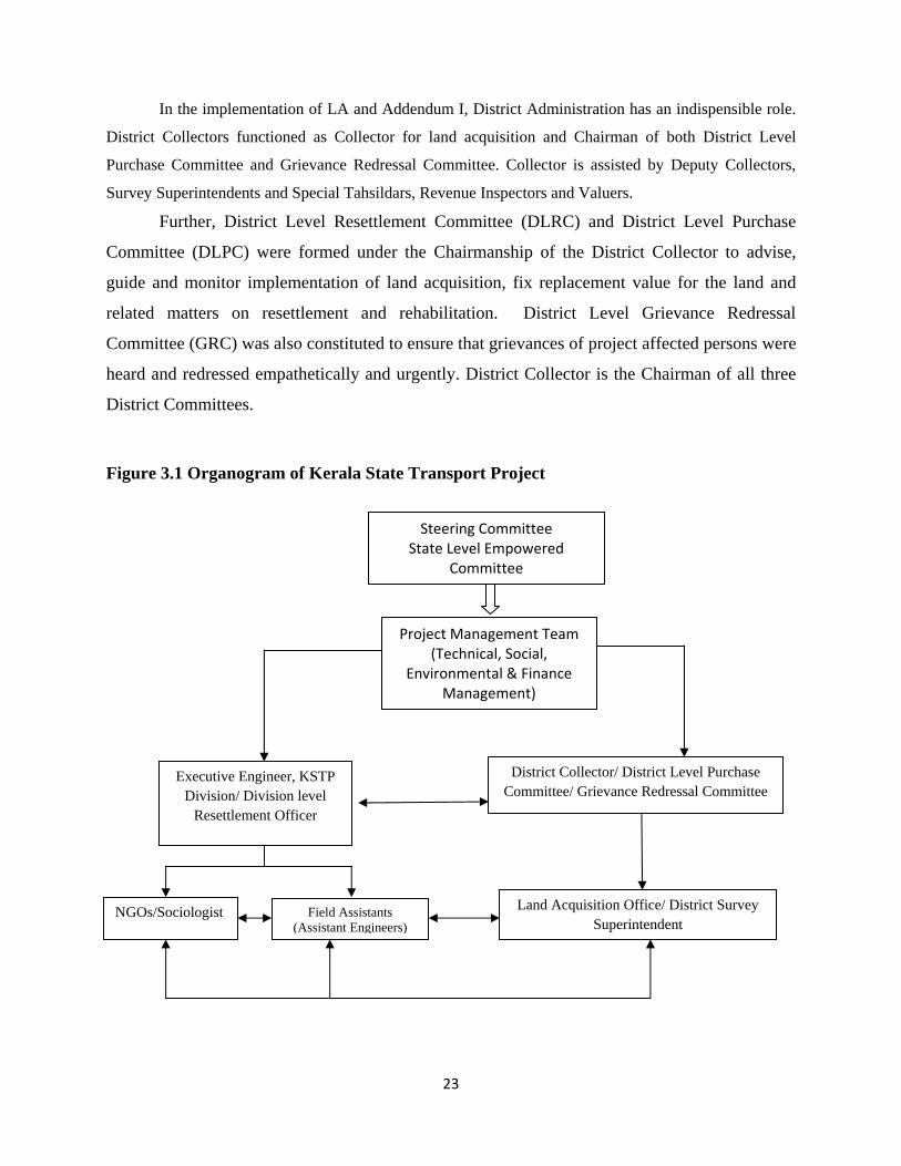
Figure 3.1 Organogram of Kerala State Transport Project
Steering Committee State Level Empowered
Committee
Project Management Team (Technical, Social,
Environmental & Finance Management)
District Collector/ District Level Purchase Committee/ Grievance Redressal Committee
Executive Engineer, KSTP Division/ Division level
Resettlement Officer
Land Acquisition Office/ District Survey Superintendent
Field Assistants (Assistant Engineers)
NGOs/Sociologist
24
3.2.1 Project Management Team (PMT)
PMT consisting of the Technical, Social, Environmental and Finance Management Cells is
headed the Project Director. Project Director is responsible for overall performance of all Cells. Chief
Engineer (Projects) heads the Technical Wing, Social cell is responsible for implementation of Addendum
I and action plan laid down in Chapter 6.
3.2.2 Arrangements at Division Level
At the field level, Executive Engineer of the Division assisted by NGOs/Sociologists and Field
Engineers implement Addendum I and provisions of Chapter 6. For land acquisition, Executive Engineer
gets the support and cooperation of District Collector assisted by Special Tahsildar and his team.
3.3 Roles and Responsibilities
Following table presents the roles and responsibilities of the key staff on deputation from the
Public Works Department and the NGOs and Sociologists procured on contract basis and posted at the
office of the PMT and at the KSTP Divisions. The Exception is the collegiums of Secretaries constituting
the Steering and Empowered Committees and the personnel from the Revenue Department working at the
district level for land acquisition under the LA units, DLPC and GRC.
Table 3.1 Roles and Responsibilities of Key Staff
Committee/Staff Roles and Responsibilities
Steering Committee/ State Level Empowered Committee (SLEC)
• Policy level decisions • Approval of financial commitments, budgets, estimates and
expenditures • Approval of land value fixed through negotiation with the land owners
by DLPC Project Director • Oversees the progress of land acquisition and R & R activities.
• Conducts review meetings of KSTP at state level • Contracts consultants, contractors and NGOs for the implementation of
the Addendum I and II. • Coordinates with other Government line Departments and NGOs for
ensuring effective delivery of mitigation and rehabilitation support. • Approves microplans and the R&R assistance
25
Committee/Staff Roles and Responsibilities
Chief Engineer • Monitors and oversees the progress of land acquisition and RAP Implementation activities.
• Participates in the district level committees to facilitate land acquisition.
• Conducts review meetings at division/district level • Coordinates with other Government line Departments and NGOs for
ensuring effective delivery of mitigation and rehabilitation support. • Sends requisitions for land acquisition to the Revenue Department. • Coordinates and supervises the civil works among the PWD Divisions. • Ensures that the contractor has paid the mutually agreed amount to
the people for the land taken over as borrow areas. And ensure that the land is returned to the owner within the stipulated time as per the agreement and has not been made unproductive.
R&R Coordinator, Social Cell, PMT
• Prepares Land acquisition and implementation plans, coordinates LA and R & R implementation activities at division level with in‐house field staff, sociologists and NGOs.
• Makes budgetary provisions for land acquisition and R & R activities at the division level and state level.
• Coordinates and conducts capacity building programmes for NGOs and in house staff engaged in R&R implementation
• Prepares monthly and quarterly progress reports
R&R Coordinator, Social Cell, PMT (continued)
• Prepares terms of reference and facilitate the appointment of external
agencies for monitoring and evaluation (M&E). • Monitors performance of NGOs and sociologists at division level and
recommends corrective measures • Monitors the progress of land acquisition, public consultations at the
road link level, and grievance redressal at district level. • Convenes review meetings in consultation with Project Director/Chief
Engineer at PMT level • Makes regular field visits and attends division level review meetings
clears doubts and provides expert guidance. • Consolidates DLPC reports and presents to SLEC for approval • Advises Project Director and Chief Engineer on LA and R&R
implementation • Scrutinizes consolidated microplans and recommends allocation of
funds for LA and R&R implementation
Finance Controller and Finance Manager (Finance Management Services (PFMS)
• Keeps formal accounts for all project funding and prepares financial statements for various purposes and cooperate with Government audits
26
Committee/Staff Roles and Responsibilities
Division level R & R Officer (Executive Engineer)
• Prepares land acquisition plans at district level and submits requisition to District Collector.
• Makes budgetary provisions for land acquisition and R & R activities at the division level.
• Coordinates land acquisition activities and implementation of R & R activities with in‐house field staff, sociologists and NGOs.
• Consolidates the microplans prepared by the NGO on physical and financial needs and prepares implementation plans on a monthly and quarterly basis and reports to PMT regularly.
• Coordinates, supervises and monitors LA and R&R activities at division level.
• Liaises with district administration for support for land acquisition and implementation of R & R.
• Organizes direct purchase of land after successful negotiation with the PAPs by the DLPC
• Organizes timely disbursement of cheques for assistance and compensation to the entitled persons based on progress in asset acquisition/utilization based on the installments agreed upon
• Convenes DLPC meetings and Grievance Redressal meetings in consultation with District Collector, the Chairman
• Prepares monthly progress reports.
Division level R & R Officer‐ Executive Engineer (continued)
• Chairs public consultations at the road link level and clears doubts on technical and financial matters and implications.
• Prepares terms of reference and facilitate the appointment of external agencies for monitoring and evaluation (M&E).
• Coordinates with the NGOs appointed for the implementation of the R & R.
• Organizes monthly meetings with the NGOs to review the progress on R & R.
• Keeps formal accounts for all project funding and prepare for and cooperate with Government audits.
District Level Grievance Redress Committee (GRC)
• Effects redress of grievances PAFs and PDFs related to category of land,
perceived inadequacy compensation and assistance, disputes on extent of land being acquired, etc.
District Level Purchase Committee (DLPC): District Collector: Chairman Executive Engineer: Convener Members: Revenue Division Officer Finance Officer of Collectorate Deputy Collector (LA)
• Responsible for land acquisition and R & R activities in the field. • Keep abreast with the different categories of affected land and the
market price and Government approved fair value of each • Convenes and participates in the DLPC, facilitates the reaching
consensus. • Monitors implementation of the R&R without any room for grievances
from PAPs. • Reports to the SLEC • Reviews and revises land value based on negotiation and in response
to grievance redressal. • Participates in the allotment of residential, commercial and agricultural
plots.
27
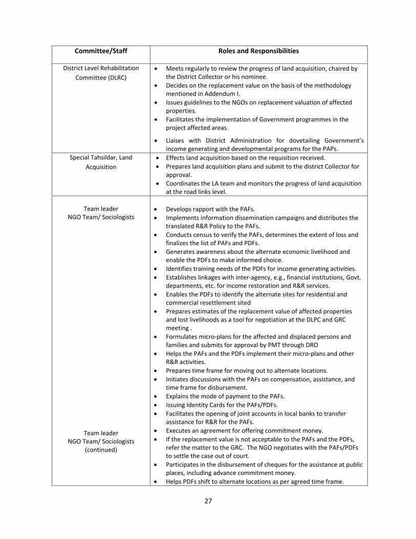
Committee/Staff Roles and Responsibilities
District Level Rehabilitation Committee (DLRC)
• Meets regularly to review the progress of land acquisition, chaired by the District Collector or his nominee.
• Decides on the replacement value on the basis of the methodology mentioned in Addendum I.
• Issues guidelines to the NGOs on replacement valuation of affected properties.
• Facilitates the implementation of Government programmes in the project affected areas.
• Liaises with District Administration for dovetailing Government’s income generating and developmental programs for the PAPs.
Special Tahsildar, Land Acquisition
• Effects land acquisition based on the requisition received. • Prepares land acquisition plans and submit to the district Collector for
approval. • Coordinates the LA team and monitors the progress of land acquisition
at the road links level.
Team leader NGO Team/ Sociologists
Team leader NGO Team/ Sociologists
(continued)
• Develops rapport with the PAFs. • Implements information dissemination campaigns and distributes the
translated R&R Policy to the PAFs. • Conducts census to verify the PAFs, determines the extent of loss and
finalizes the list of PAFs and PDFs. • Generates awareness about the alternate economic livelihood and
enable the PDFs to make informed choice. • Identifies training needs of the PDFs for income generating activities. • Establishes linkages with inter‐agency, e.g., financial institutions, Govt.
departments, etc. for income restoration and R&R services. • Enables the PDFs to identify the alternate sites for residential and
commercial resettlement sited • Prepares estimates of the replacement value of affected properties
and lost livelihoods as a tool for negotiation at the DLPC and GRC meeting .
• Formulates micro‐plans for the affected and displaced persons and families and submits for approval by PMT through DRO
• Helps the PAFs and the PDFs implement their micro‐plans and other R&R activities.
• Prepares time frame for moving out to alternate locations. • Initiates discussions with the PAFs on compensation, assistance, and
time frame for disbursement. • Explains the mode of payment to the PAFs. • Issuing Identity Cards for the PAFs/PDFs. • Facilitates the opening of joint accounts in local banks to transfer
assistance for R&R for the PAFs. • Executes an agreement for offering commitment money. • If the replacement value is not acceptable to the PAFs and the PDFs,
refer the matter to the GRC. The NGO negotiates with the PAFs/PDFs to settle the case out of court.
• Participates in the disbursement of cheques for the assistance at public places, including advance commitment money.
• Helps PDFs shift to alternate locations as per agreed time frame.
28
Committee/Staff Roles and Responsibilities
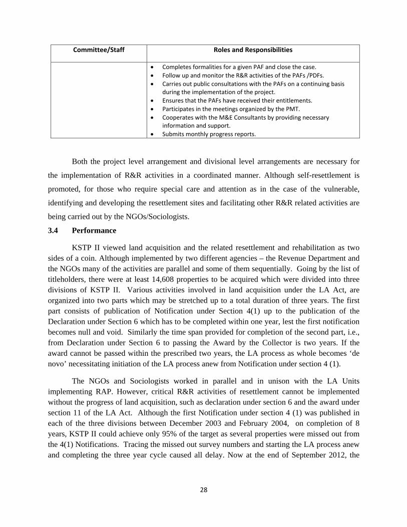
• Completes formalities for a given PAF and close the case. • Follow up and monitor the R&R activities of the PAFs /PDFs. • Carries out public consultations with the PAFs on a continuing basis
during the implementation of the project. • Ensures that the PAFs have received their entitlements. • Participates in the meetings organized by the PMT. • Cooperates with the M&E Consultants by providing necessary
information and support. • Submits monthly progress reports.
Both the project level arrangement and divisional level arrangements are necessary for
the implementation of R&R activities in a coordinated manner. Although self-resettlement is
promoted, for those who require special care and attention as in the case of the vulnerable,
identifying and developing the resettlement sites and facilitating other R&R related activities are
being carried out by the NGOs/Sociologists.
3.4 Performance
KSTP II viewed land acquisition and the related resettlement and rehabilitation as two sides of a coin. Although implemented by two different agencies – the Revenue Department and the NGOs many of the activities are parallel and some of them sequentially. Going by the list of titleholders, there were at least 14,608 properties to be acquired which were divided into three divisions of KSTP II. Various activities involved in land acquisition under the LA Act, are organized into two parts which may be stretched up to a total duration of three years. The first part consists of publication of Notification under Section 4(1) up to the publication of the Declaration under Section 6 which has to be completed within one year, lest the first notification becomes null and void. Similarly the time span provided for completion of the second part, i.e., from Declaration under Section 6 to passing the Award by the Collector is two years. If the award cannot be passed within the prescribed two years, the LA process as whole becomes ‘de novo’ necessitating initiation of the LA process anew from Notification under section 4 (1).
The NGOs and Sociologists worked in parallel and in unison with the LA Units implementing RAP. However, critical R&R activities of resettlement cannot be implemented without the progress of land acquisition, such as declaration under section 6 and the award under section 11 of the LA Act. Although the first Notification under section 4 (1) was published in each of the three divisions between December 2003 and February 2004, on completion of 8 years, KSTP II could achieve only 95% of the target as several properties were missed out from the 4(1) Notifications. Tracing the missed out survey numbers and starting the LA process anew and completing the three year cycle caused all delay. Now at the end of September 2012, the
29
achievement is 98% and the attempt is to complete the remaining 2% before the end of 2012. In addition, land for link 41&47 of 10.2 ha will be acquired by end of 2013.
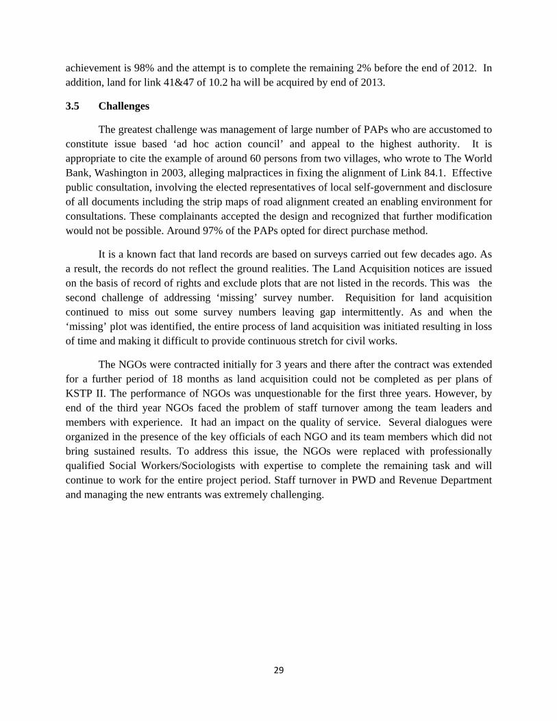
3.5 Challenges
The greatest challenge was management of large number of PAPs who are accustomed to constitute issue based ‘ad hoc action council’ and appeal to the highest authority. It is appropriate to cite the example of around 60 persons from two villages, who wrote to The World Bank, Washington in 2003, alleging malpractices in fixing the alignment of Link 84.1. Effective public consultation, involving the elected representatives of local self-government and disclosure of all documents including the strip maps of road alignment created an enabling environment for consultations. These complainants accepted the design and recognized that further modification would not be possible. Around 97% of the PAPs opted for direct purchase method.
It is a known fact that land records are based on surveys carried out few decades ago. As a result, the records do not reflect the ground realities. The Land Acquisition notices are issued on the basis of record of rights and exclude plots that are not listed in the records. This was the second challenge of addressing ‘missing’ survey number. Requisition for land acquisition continued to miss out some survey numbers leaving gap intermittently. As and when the ‘missing’ plot was identified, the entire process of land acquisition was initiated resulting in loss of time and making it difficult to provide continuous stretch for civil works.
The NGOs were contracted initially for 3 years and there after the contract was extended for a further period of 18 months as land acquisition could not be completed as per plans of KSTP II. The performance of NGOs was unquestionable for the first three years. However, by end of the third year NGOs faced the problem of staff turnover among the team leaders and members with experience. It had an impact on the quality of service. Several dialogues were organized in the presence of the key officials of each NGO and its team members which did not bring sustained results. To address this issue, the NGOs were replaced with professionally qualified Social Workers/Sociologists with expertise to complete the remaining task and will continue to work for the entire project period. Staff turnover in PWD and Revenue Department and managing the new entrants was extremely challenging.
30
CHAPTER – IV
IMPLEMENTATION PROCESS AND
PROGRESS OF ADDENDUM I
31
4.0 Introduction
As already stated in the previous chapters, Addendum I is the outcome of several
studies such as reconnaissance, social impact assessment, social survey and census conducted by
the PCC based on the area marked for acquisition. In order to implement Addendum I, NGOs
were hired and under the direct supervision of the Executive Engineer of the KSTP Division, that
was initiated in November 2003 and is going on. There is a balance of about 3% of land along 7
links to be acquired and associated R&R which will be completed before the end of 2012 and
10.2 ha for link 41 and 47 to be completed by end 2014.
4.1 Information Dissemination and Consultation
The first initiative was to disseminate to the people living along on either side of the
project road about the project – upgradation of the road. Meetings were organised locality-wise
and the participants were given the details of the new road along with the advantages of a
developed road in user friendly language. They were also informed about the potential adverse
impact caused by land acquisition. In addition, information about NGOs’ scope of work was also
disseminated; the teams were introduced to the people; they would work to facilitate the process
of land acquisition, resettlement and rehabilitation over the next three years. Further, they were
informed of the principles and objectives of the R&R Policy which upholds participation of the
people, transparency in the processes and procedures and accountability to the public. The
assurance that all documents would be available for perusal at the Grama Panchyats, NGO’s
office, District Head Quarters and the KSTP Division Office and disclosure of contact persons,
address and phone numbers added credibility and reduced their anxiety.
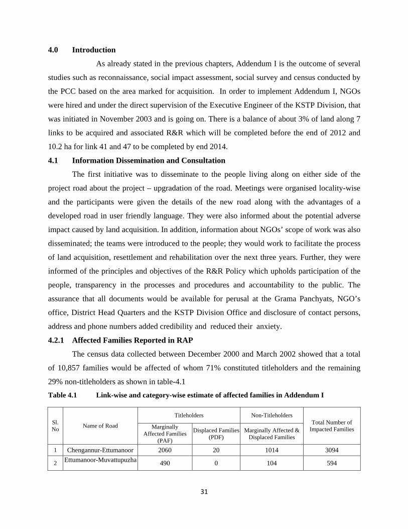
4.2.1 Affected Families Reported in RAP
The census data collected between December 2000 and March 2002 showed that a total
of 10,857 families would be affected of whom 71% constituted titleholders and the remaining
29% non-titleholders as shown in table-4.1
Table 4.1 Link-wise and category-wise estimate of affected families in Addendum I
Sl. No Name of Road
Titleholders Non-Titleholders Total Number of
Impacted Families Marginally Affected Families
(PAF)
Displaced Families (PDF)
Marginally Affected & Displaced Families
1 Chengannur-Ettumanoor 2060 20 1014 3094
2 Ettumanoor-Muvattupuzha 490 0 104 594
32
3 Pilathara-Pappinissery 448 6 178 632
4 Kasaragod-Kanhangad 186 9 133 328
5 Thalassery- Valavupara 1206 56 665 1927
6 Punalur-Ponkunnam 2007 73 685 2765
7 Ponkunnam-Thodupuzha 1015 131 371 1517
4 Total 7412 295 3150 10857 5 Percentage 68.27 2.72 29.01 100.0
4.2.2 Number of Affected Families at the Time of Implementation
After necessary orientation and training, six NGO teams conducted the census and socio-
economic survey of affected families within the corridor of impact (CoI) using structured
interview schedules. The NGO conducted census survey including the socioeconomic profile of
the family, analyzed the data and assessed the extent of loss, classified the impact and
documented the same using the database management system and generated a land schedule and
compared the same with the data provided in Addendum I and prepared relevant reports. Based
on the analysis of the data gathered during the social survey, the NGOs categorized the PAFs/
PAPs into broad categories of viz., Title holder Non-Title holder, Vulnerable, Non-vulnerable,
and displaced and affected. Project Affected Families (PAFs) included owners and users of the
property. Census revealed that the number of affected families increased by 91% above the
estimate in Addendum I.
When titleholders and non-titleholders are considered separately the difference in non-
titleholders is slightly higher with 94.86% increase. Possibility of increase in number was
primarily due to (a) PCC had stated as unknown when owner could not be identified. These
unidentified and unknown land owners staying elsewhere responded when land acquisition
process started, (b) fragmentation of property by partitioning of family property, (c) sales of land
in the wake of real estate boom, (d) there was possible under-reporting of employees by the shop
owners fearing Government action for non-implementation of labour welfare measures on their
part, (e) squatters were left out from the PCC’s enumeration, were subsequently identified by the
NGOs, in spite of the fact that they were bona fide residents of the place for long time having
house numbers possessing ration card and voter identity cards.

33
4.2.3 Extent of Impact on Families
Social survey applied the bandwidth technique to categorise the impact which was based
on the extent of loss. As land acquisition is along the existing road on either side, the affected
property happens to be a narrow strip of land in most cases. Those who lost less than 10% of
their landed property are grouped as marginally affected families. These properties may be with
or without compound walls. The second category is listed as significantly affected. This group
consists of those who lost 10-20% of their property involving part of their residential or
commercial structures. The third category consists of displaced families from their residence or
commercial establishments or other avocations due to acquisition of land and demolition of the
structures. Table 4.2 Impact on Families – Titleholders and Non-titleholders
Sl. No
Name of Road
TITLEHOLDERS NON‐TITLEHOLDERS Grand Total
Marginally affected families
Significantly affected families
Displaced families
TOTAL Displaced Families
Significantly affected families
TOTAL
1 Chengannur Ettumanoor
2278 273 51
2602 348 724 1072 3674
2 Ettumanoor‐Muvattupuzha 1464 72 76 1612 530 431 961 2573
3 Pilathara‐
Pappinissery 1125 20 91 1236 232 166 398 1634
4 Kasaragod‐ Kanhangad
381 9 63
453 360 124 484 937
5
Thalassery‐ Valavupara
2412 617 62 3091 491 1384 1875 4966
6 Punalur‐
Ponkunnam 2231 79 89 2399 350 332 682 3081
7 Ponkunnam‐Thodupuzha 2990 110 115 3215 420 196 616 3831
8
Total 12881 1144 583 14608 2731 3357 6088 20696
9
Percentage 62.2 5.7 2.6 70.6 13.2 16.2 29.4 100.0
Average size of family in Kerala being five, total affected persons (20696 x 5) by 7 road
links are about 103,480 of whom displaced persons are 16,570 and constitute 15.8% of the total
impacted by KSTP-II. As Table 4.2 shows, nearly two thirds of the families are marginally
affected while significantly affected families due to partial demolition of the structures
constituted about 22% of the impacted population.
34
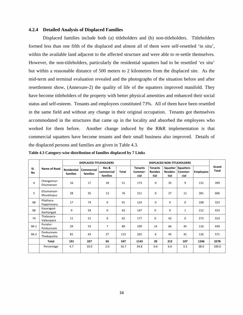
4.2.4 Detailed Analysis of Displaced Families
Displaced families include both (a) titleholders and (b) non-titleholders. Titleholders
formed less than one fifth of the displaced and almost all of them were self-resettled ‘in situ’,
within the available land adjacent to the affected structure and were able to re-settle themselves.
However, the non-titleholders, particularly the residential squatters had to be resettled ‘ex situ’
but within a reasonable distance of 500 meters to 2 kilometres from the displaced site. As the
mid-term and terminal evaluation revealed and the photographs of the situation before and after
resettlement show, (Annexure-2) the quality of life of the squatters improved manifold. They
have become titleholders of the property with better physical amenities and enhanced their social
status and self-esteem. Tenants and employees constituted 73%. All of them have been resettled
in the same field and without any change in their original occupation. Tenants got themselves
accommodated in the structures that came up in the locality and absorbed the employees who
worked for them before. Another change induced by the R&R implementation is that
commercial squatters have become tenants and their small business also improved. Details of
the displaced persons and families are given in Table 4.3. Table 4.3 Category-wise distribution of families displaced by 7 Links
Sl. No
Name of Road
DISPLACED TITLEHOLDERS DISPLACED NON‐TITLEHOLDERS Grand Total Residential
families Commercial families
Res & commercial families
Total Tenants Commer‐
cial
Tenants Residential
Squatter Residen‐
tial
Squatters Commer‐
cial Employees
4 Chengannur‐Ettumanoor
16 17 18 51 173 0 35 9 131 399
5 Ettumanoor‐Muvattupuz
28 35 13 76 211 0 27 11 281 606
68 Pilathara‐ Pappinissery
17 74 0 91 124 0 0 0 108 323
68 Kasaragod‐ Kanhangad
9 54 0 63 147 0 0 1 212 423
74 Thalassery‐ Valavupara
11 51 0 62 177 0 42 0 272 553
84.1 Punalur‐Ponkunnam
29 53 7 89 109 14 66 45 116 439
84.2 Ponkunnam‐Thodupuzha
81 43 27 115 202 6 45 41 126 571
Total 191 327 65 547 1143 20 215 107 1246 3278
Percentage 4.7 10.0 2.0 16.7 34.8 0.6 6.6 3.3 38.0 100.0
35
4.3 Issuing Identity Cards
On completion of the social survey, survey of the land, verification and categorization of the
PAF, identity cards were issued to Entitled Persons (EP) authenticated by the Executive Engineer, KSTP.
These identity cards also contained details of lost assets, their compensation and the various categories of
assistance due to the EP. This and the disclosure of project details made project implementation
transparent which the opinion leaders and the general public appreciated.
4.4 Preparation of Micro Plans
One of the most important tasks of the NGO was preparation of the micro plan in consultation
with the PAPs. Participatory methodologies were applied to involve family members, particularly women
in the family to positively assess the loss, constructively plan the resettlement and rehabilitation and
effectively utilize the replacement value and other assistances. Restoration of lost livelihood, assets and
opportunities was given prime importance. All efforts in the preparation of the microplan were geared
towards the improvement of the standard of living utilizing the available opportunities, including
upgradation of skills. Documented microplan has two dimensions. The first part of the micro plan is a
case study (summarized write up of each case) and the second part is the financial aspect which quantifies
all the entitlements of a PAP/PDP in monitory terms under various heads in appropriate formats of
microplan of Titleholders, Non-titleholders, Cultural Property or Community Property Resources, as the
case could be.
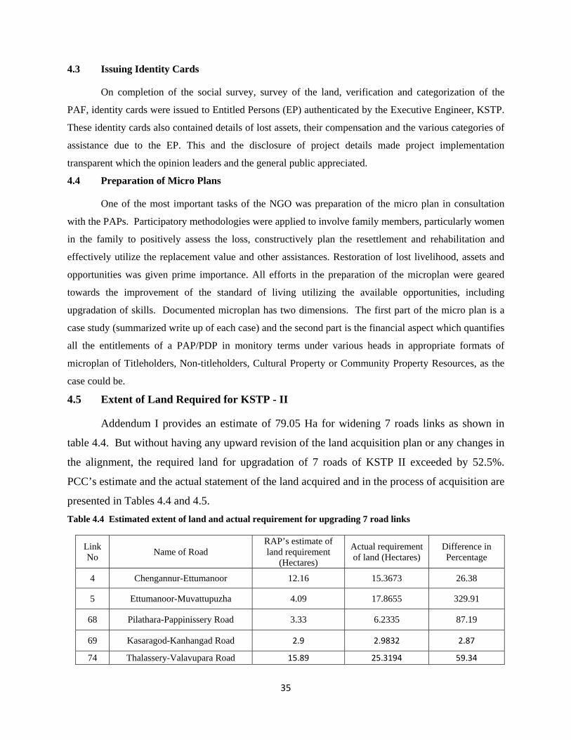
4.5 Extent of Land Required for KSTP - II
Addendum I provides an estimate of 79.05 Ha for widening 7 roads links as shown in
table 4.4. But without having any upward revision of the land acquisition plan or any changes in
the alignment, the required land for upgradation of 7 roads of KSTP II exceeded by 52.5%.
PCC’s estimate and the actual statement of the land acquired and in the process of acquisition are
presented in Tables 4.4 and 4.5. Table 4.4 Estimated extent of land and actual requirement for upgrading 7 road links
Link No Name of Road
RAP’s estimate of land requirement
(Hectares)
Actual requirement of land (Hectares)
Difference in Percentage
4 Chengannur-Ettumanoor 12.16 15.3673 26.38
5 Ettumanoor-Muvattupuzha 4.09 17.8655 329.91
68 Pilathara-Pappinissery Road 3.33 6.2335 87.19
69 Kasaragod-Kanhangad Road 2.9 2.9832 2.87
74 Thalassery-Valavupara Road 15.89 25.3194 59.34
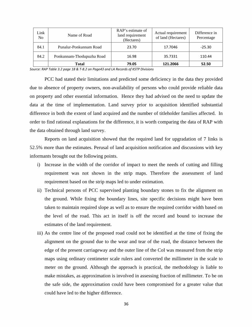
36
Link No Name of Road
RAP’s estimate of land requirement
(Hectares)
Actual requirement of land (Hectares)
Difference in Percentage
84.1 Punalur-Ponkunnam Road 23.70 17.7046 ‐25.30
84.2 Ponkunnam-Thodupuzha Road 16.98 35.7331 110.44
Total 79.05 121.2066 52.50 Source: RAP Table 3.2 page 18 & T‐8.2 on Page43 and LA Records of KSTP Divisions
PCC had stated their limitations and predicted some deficiency in the data they provided
due to absence of property owners, non-availability of persons who could provide reliable data
on property and other essential information. Hence they had advised on the need to update the
data at the time of implementation. Land survey prior to acquisition identified substantial
difference in both the extent of land acquired and the number of titleholder families affected. In
order to find rational explanations for the difference, it is worth comparing the data of RAP with
the data obtained through land survey.
Reports on land acquisition showed that the required land for upgradation of 7 links is
52.5% more than the estimates. Perusal of land acquisition notification and discussions with key
informants brought out the following points.
i) Increase in the width of the corridor of impact to meet the needs of cutting and filling
requirement was not shown in the strip maps. Therefore the assessment of land
requirement based on the strip maps led to under estimation.
ii) Technical persons of PCC supervised planting boundary stones to fix the alignment on
the ground. While fixing the boundary lines, site specific decisions might have been
taken to maintain required slope as well as to ensure the required corridor width based on
the level of the road. This act in itself is off the record and bound to increase the
estimates of the land requirement.
iii) As the centre line of the proposed road could not be identified at the time of fixing the
alignment on the ground due to the wear and tear of the road, the distance between the
edge of the present carriageway and the outer line of the CoI was measured from the strip
maps using ordinary centimeter scale rulers and converted the millimeter in the scale to
meter on the ground. Although the approach is practical, the methodology is liable to
make mistakes, as approximation is involved in assessing fraction of millimeter. To be on
the safe side, the approximation could have been compromised for a greater value that
could have led to the higher difference.
37
iv) Another important finding is that the RoW in the old records showed availability of large
tracts of land along the existing road as revenue ‘puramboke’. But over the years,
Government allotted these lands to persons and institutions. But change in the ownership
was not updated in the revenue records. Hence village records showed outdated data
which caused incorrect estimate. During land acquisition process, quite a few properties
considered to be government land had already become private land.
4.5.1 Process of Land Acquisition, Resettlement and Rehabilitation
Land Acquisition Act, 1894 (amended in 1984) is the law for procedures to be followed
for acquisition of land by the Government for public purposes and for determining
compensation. While this Act does not per se provide for mitigation measures, its Section 23
discusses compensation at market price, the market value of land being determined "at the date
of the publication of the notification."
For any land acquisition by the Government, the Land Acquisition Act under section 4(1)
stipulates publication of a notification to that effect in the official Gazette and in two daily
newspapers circulated in the locality. After a statutory period of 30 days for filing objections the
Land Acquisition Officer (LAO) will hear objections to the proposed acquisition under section
5A of the LA Act. As KSTP places special emphasis on the information dissemination process
through personal contact and the audio-visual media, R&R units in each division are to ensure
that each affected PAP is fully aware of the procedures and their possibilities and rights to
participate in the process.
In order to proceed with the acquisition of the notified land or any portion of it, a
declaration under section 6 of the Act specifying the precise boundaries of the area of the land
need to be made. Every declaration is to be published in the official gazette and in two daily
newspapers, which have circulation in the local areas. With the appearance of the notification
under section 6 of the Act in the Gazette, the Revenue Department issues a direction to the
Collector under section 7 of the Act to issue the order for acquisition of the notified land and/or
other immovable properties. Section 8 of the Act requires land to be marked out, measured and
planned, while under section 9 notices are served to the concerned person stating the intention of
the Government to take possession of the land and that any claims for compensation should be
made to the Collector. Finally, the award of compensation is made by the Collector under
38
section 11 of the Act after enquiring into objections (if any) in pursuant to the notice given under
section 9, to the measurements made under section 8 and into the value of the land on the date of
publication of the notification under section 4(1). The award under section 11 is made within
two years from the date of publication of the declaration and if no award is made within this
period the entire proceedings of the land acquisition lapses and a fresh notification needs to be
initiated. Once the award is made, the Collector takes possession of the land, which thereupon
vests absolutely in the Government free from all encumbrances. Completion of these processes
is expected to take about 3 years, i.e., one year from Notification under Section 4 (1) to
declaration under Section 6(1) and two years from Declaration 6(1) to award under section 11.
Therefore, to cut short the long drawn process, KSTP adopted direct purchase method after
publishing the Declaration under section 6 (1).
4.5.2 Direct Purchase Method
The main tool for direct purchase is the negotiation by the DLPC with the land owners in
groups and on reaching a consensus an agreement is signed to register the sale deed on payment
of the amount mutually agreed. However, if the owner of the land does not have the required
documents to transact the sale deed, or he/she is not cooperative, the LA process will be
completed till award under section 11 of the LA Act. Irrespective of the method of land
acquisition, KSTP utilised the services of NGOs and Sociologists who counselled the affected
and entitled persons to ensure their active participation in the implementation of the RAP. These
practices led to a positive attitudinal change in the people of Kerala towards land acquisition for
development projects.
4.5.3 Counselling the Entitled Persons
Anticipating the issues that accompany the land acquisition process, whether by LA
process or by direct purchase, the NGOs informed the entitled persons to keep ready all required
original documents necessary for receiving compensation and R&R entitlements. The process
of collecting relevant documents required adequate time. In the absence of the necessary
documents to prove the ownership of the property, the land acquisition office would have to
proceed with land acquisition process by depositing the compensation in the Court. Situation
arising from the death of the titleholder or dispute among the titleholders who jointly owned the
property also caused problems in receiving the compensation Hence the PAPs were provided
39
written information well in advance to keep those documents ready for compensation. The
NGO facilitated this process and implementation of LA and R&R went off smoothly.
The non-titleholders (tenants, squatters, encroachers and employees) were also
counselled of their rights to the entitlements in accordance with the R&R Policy. Residential
Squatters were required to produce a certificate from the village officer to prove their squatter
status, that is, they do not possess any land in the village. All Non-titleholders were assisted in
planning their resettlement, utilizing the opportunity to upgrade or develop new skills to improve
coping capacity and their living standard as well.
4.6 Participatory Process in Fixing Replacement Value of Land
Fixing replacement value of land was a major challenge KSTP. Land is the scarcest
resource and its location is linked with opportunities. In order to systematically assess the value
of land, Approved Valuers from the Institution of Engineers were engaged till the project
officials learnt the process. After preparing the assessment, affected land owners of each village
were grouped under specific category of land and the District Level Purchase Committee
(DLPC) negotiated with each group of land owners until consensus was reached. The process of
negotiation with the DLPC turned out to be an empowering experience for most of the EPs.
4.7 Time Taken to Implement Land Acquisition and R&R Processes of Phase II
Land acquisition process for Phase II started in 2004 in three KSTP divisions to which
the implementation of RAP was linked. Although the LA process covering 61.43 Ha (50.77%)
was completed by the end of 2006, it was realised that 1443 plots of land and properties
measuring 3.5964 hectares were excluded from acquisition. Survey numbers of these properties
were not included in the original list published under Section 4 (1) of the Land Acquisition Act.
Hence the process had to be started again for those missed out properties. Similarly when the
LA process at other villages were completed in 2008 and 2010 another 1162 properties totalling
4.58 hectares were identified to have been missed out, requiring initiation of LA process anew.
Table 3.2 gives the details of LA process for each road showing the series of notifications which
excludes the last tranche of ‘missing’ survey numbers covering 566 properties with an extent of
3.46 hectares. On an average it took a year and half to acquire land.
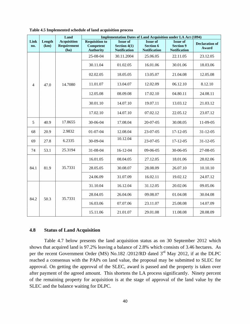
40
Table 4.5 Implemented schedule of land acquisition process
Link no.
Length (km)
Land Acquisition
Requirement (ha)
Implementation Dates of Land Acquisition under LA Act (1894) Requisition to
Competent Authority
Issue of Section 4(1) Notification
Issue of Section 6
Notification
Issue of Section 9
Notification
Declaration of Award
4 47.0 14.7080
25-08-04 30.11.2004 25.06.05 22.11.05 23.12.05
30.11.04 01.02.05 16.01.06 30.01.06 18.03.06
02.02.05 18.05.05 13.05.07 21.04.08 12.05.08
11.01.07 13.04.07 12.02.09 06.12.10 8.12.10
12.05.08 08.09.08 17.02.10 04.80.11 24.08.11
30.01.10 14.07.10 19.07.11 13.03.12 21.03.12
17.02.10 14.07.10 07.02.12 22.05.12 23.07.12
5 40.9 17.8655 30-06-04 17.08.04 20-07-05 30.08.05 11-09-05
68 20.9 2.9832 01-07-04 12.08.04 23-07-05 17-12-05 31-12-05
69 27.8 6.2335 30-09-04 10.12.04 23-07-05 17-12-05 31-12-05
74 53.1 25.3194 31-08-04 16-12-04 09-06-05 30-06-05 27-08-05
84.1 81.9 35.7331
16.01.05 08.04.05 27.12.05 18.01.06 28.02.06
28.05.05 30.08.07 28.08.09 26.07.10 10.10.10
24.06.09 31.07.09 16.02.11 19.02.12 24.07.12
84.2 50.3 35.7331
31.10.04 16.12.04 31.12.05 20.02.06 09.05.06
28.04.05 26.04.06 09.08.07 01.04.08 30.04.08
16.03.06 07.07.06 23.11.07 25.08.08 14.07.09
15.11.06 21.01.07 29.01.08 11.08.08 28.08.09
4.8 Status of Land Acquisition
Table 4.7 below presents the land acquisition status as on 30 September 2012 which shows that acquired land is 97.2% leaving a balance of 2.8% which consists of 3.46 hectares. As per the recent Government Order (MS) No.182 /2012/RD dated 3rd May 2012, if at the DLPC reached a consensus with the PAPs on land value, the proposal may be submitted to SLEC for approval. On getting the approval of the SLEC, award is passed and the property is taken over after payment of the agreed amount. This shortens the LA process significantly. Ninety percent of the remaining property for acquisition is at the stage of approval of the land value by the SLEC and the balance waiting for DLPC.
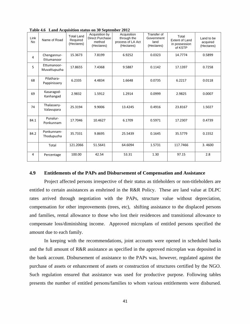
41
Table 4.6 Land Acquisition status on 30 September 2012
Link No Name of Road
Total Land Required
(Hectares)
Acquisition by Direct Purchase
method (Hectares)
Acquisition through the
process of LA Act (Hectares)
Transfer of Government
land (Hectares)
Total Extent of Land in possession
of KSTP
Land to be acquired
(Hectares)
4 Chengannur‐Ettumanoor
15.3673 7.8199 6.9252 0.0323 14.7774 0.5899
5 Ettumanoor‐Muvattupuzha
17.8655 7.4368 9.5887 0.1142 17.1397 0.7258
68 Pilathara‐Pappinissery
6.2335 4.4834 1.6648 0.0735 6.2217 0.0118
69 Kasaragod‐Kanhangad
2.9832 1.5912 1.2914 0.0999 2.9825 0.0007
74 Thalassery‐ Valavupara
25.3194 9.9006 13.4245 0.4916 23.8167 1.5027
84.1 Punalur‐Ponkunnam
17.7046 10.4627 6.1709 0.5971 17.2307 0.4739
84.2 Ponkunnam‐Thodupuzha
35.7331 9.8695 25.5439 0.1645 35.5779 0.1552
Total 121.2066 51.5641 64.6094 1.5731 117.7466 3. 4600
4 Percentage 100.00 42.54 53.31 1.30 97.15 2.8
4.9 Entitlements of the PAPs and Disbursement of Compensation and Assistance
Project affected persons irrespective of their status as titleholders or non-titleholders are
entitled to certain assistances as enshrined in the R&R Policy. These are land value at DLPC
rates arrived through negotiation with the PAPs, structure value without depreciation,
compensation for other improvements (trees, etc), shifting assistance to the displaced persons
and families, rental allowance to those who lost their residences and transitional allowance to
compensate loss/diminishing income. Approved microplans of entitled persons specified the
amount due to each family.
In keeping with the recommendations, joint accounts were opened in scheduled banks
and the full amount of R&R assistance as specified in the approved microplan was deposited in
the bank account. Disbursement of assistance to the PAPs was, however, regulated against the
purchase of assets or enhancement of assets or construction of structures certified by the NGO.
Such regulation ensured that assistance was used for productive purpose. Following tables
presents the number of entitled persons/families to whom various entitlements were disbursed.
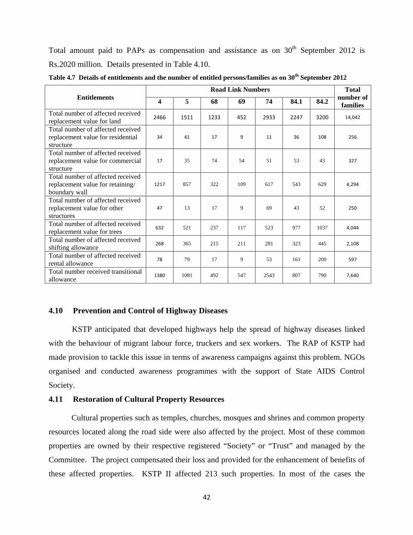
42
Total amount paid to PAPs as compensation and assistance as on 30th September 2012 is
Rs.2020 million. Details presented in Table 4.10. Table 4.7 Details of entitlements and the number of entitled persons/families as on 30th September 2012
Entitlements Road Link Numbers Total
number of families 4 5 68 69 74 84.1 84.2
Total number of affected received replacement value for land 2466 1511 1233 452 2933 2247 3200 14,042
Total number of affected received replacement value for residential structure
34 41 17 9 11 36 108 256
Total number of affected received replacement value for commercial structure
17 35 74 54 51 53 43 327
Total number of affected received replacement value for retaining/ boundary wall
1217 857 322 109 617 543 629 4,294
Total number of affected received replacement value for other structures
47 13 17 9 69 43 52 250
Total number of affected received replacement value for trees 632 521 237 117 523 977 1037 4,044
Total number of affected received shifting allowance 268 365 215 211 281 323 445 2,108
Total number of affected received rental allowance 78 79 17 9 53 161 200 597
Total number received transitional allowance 1380 1081 492 547 2543 807 790 7,640
4.10 Prevention and Control of Highway Diseases KSTP anticipated that developed highways help the spread of highway diseases linked
with the behaviour of migrant labour force, truckers and sex workers. The RAP of KSTP had
made provision to tackle this issue in terms of awareness campaigns against this problem. NGOs
organised and conducted awareness programmes with the support of State AIDS Control
Society.
4.11 Restoration of Cultural Property Resources
Cultural properties such as temples, churches, mosques and shrines and common property
resources located along the road side were also affected by the project. Most of these common
properties are owned by their respective registered “Society” or “Trust” and managed by the
Committee. The project compensated their loss and provided for the enhancement of benefits of
these affected properties. KSTP II affected 213 such properties. In most of the cases the
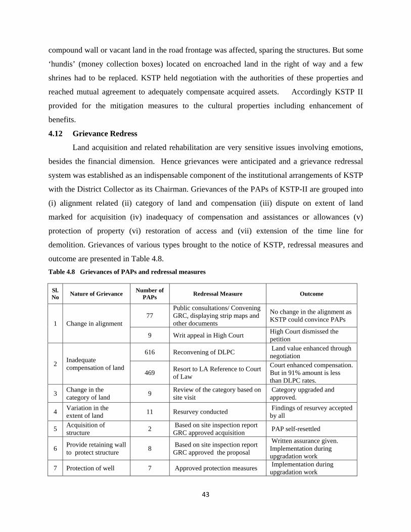
43
compound wall or vacant land in the road frontage was affected, sparing the structures. But some
‘hundis’ (money collection boxes) located on encroached land in the right of way and a few
shrines had to be replaced. KSTP held negotiation with the authorities of these properties and
reached mutual agreement to adequately compensate acquired assets. Accordingly KSTP II
provided for the mitigation measures to the cultural properties including enhancement of
benefits.
4.12 Grievance Redress
Land acquisition and related rehabilitation are very sensitive issues involving emotions,
besides the financial dimension. Hence grievances were anticipated and a grievance redressal
system was established as an indispensable component of the institutional arrangements of KSTP
with the District Collector as its Chairman. Grievances of the PAPs of KSTP-II are grouped into
(i) alignment related (ii) category of land and compensation (iii) dispute on extent of land
marked for acquisition (iv) inadequacy of compensation and assistances or allowances (v)
protection of property (vi) restoration of access and (vii) extension of the time line for
demolition. Grievances of various types brought to the notice of KSTP, redressal measures and
outcome are presented in Table 4.8. Table 4.8 Grievances of PAPs and redressal measures
Sl. No Nature of Grievance Number of
PAPs Redressal Measure Outcome
1 Change in alignment 77
Public consultations/ Convening GRC, displaying strip maps and other documents
No change in the alignment as KSTP could convince PAPs
9 Writ appeal in High Court High Court dismissed the petition
2 Inadequate compensation of land
616 Reconvening of DLPC Land value enhanced through negotiation
469 Resort to LA Reference to Court of Law
Court enhanced compensation. But in 91% amount is less than DLPC rates.
3 Change in the category of land 9 Review of the category based on
site visit Category upgraded and approved.
4 Variation in the extent of land 11 Resurvey conducted Findings of resurvey accepted
by all
5 Acquisition of structure 2 Based on site inspection report
GRC approved acquisition PAP self-resettled
6 Provide retaining wall to protect structure 8 Based on site inspection report
GRC approved the proposal
Written assurance given. Implementation during upgradation work
7 Protection of well 7 Approved protection measures Implementation during upgradation work
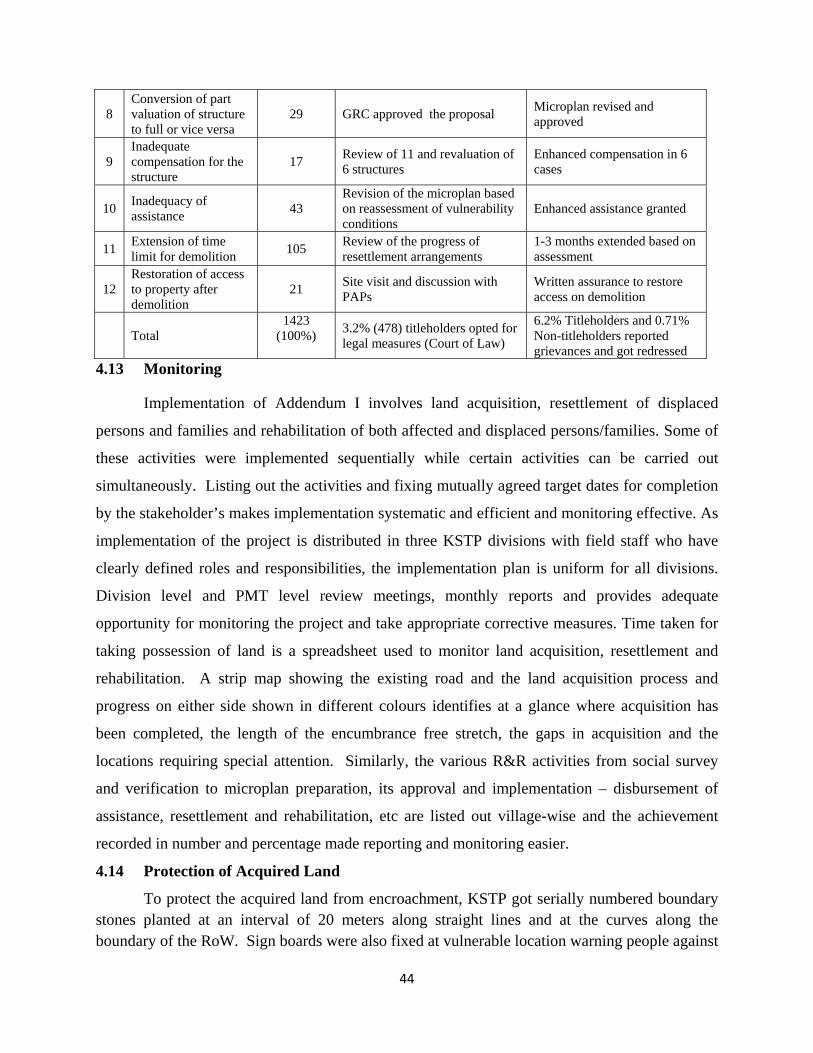
44
8 Conversion of part valuation of structure to full or vice versa
29 GRC approved the proposal Microplan revised and approved
9 Inadequate compensation for the structure
17 Review of 11 and revaluation of 6 structures
Enhanced compensation in 6 cases
10 Inadequacy of assistance 43
Revision of the microplan based on reassessment of vulnerability conditions
Enhanced assistance granted
11 Extension of time limit for demolition 105 Review of the progress of
resettlement arrangements 1-3 months extended based on assessment
12 Restoration of access to property after demolition
21 Site visit and discussion with PAPs
Written assurance to restore access on demolition
Total 1423
(100%)
3.2% (478) titleholders opted for legal measures (Court of Law)
6.2% Titleholders and 0.71% Non-titleholders reported grievances and got redressed
4.13 Monitoring
Implementation of Addendum I involves land acquisition, resettlement of displaced
persons and families and rehabilitation of both affected and displaced persons/families. Some of
these activities were implemented sequentially while certain activities can be carried out
simultaneously. Listing out the activities and fixing mutually agreed target dates for completion
by the stakeholder’s makes implementation systematic and efficient and monitoring effective. As
implementation of the project is distributed in three KSTP divisions with field staff who have
clearly defined roles and responsibilities, the implementation plan is uniform for all divisions.
Division level and PMT level review meetings, monthly reports and provides adequate
opportunity for monitoring the project and take appropriate corrective measures. Time taken for
taking possession of land is a spreadsheet used to monitor land acquisition, resettlement and
rehabilitation. A strip map showing the existing road and the land acquisition process and
progress on either side shown in different colours identifies at a glance where acquisition has
been completed, the length of the encumbrance free stretch, the gaps in acquisition and the
locations requiring special attention. Similarly, the various R&R activities from social survey
and verification to microplan preparation, its approval and implementation – disbursement of
assistance, resettlement and rehabilitation, etc are listed out village-wise and the achievement
recorded in number and percentage made reporting and monitoring easier.
4.14 Protection of Acquired Land
To protect the acquired land from encroachment, KSTP got serially numbered boundary stones planted at an interval of 20 meters along straight lines and at the curves along the boundary of the RoW. Sign boards were also fixed at vulnerable location warning people against
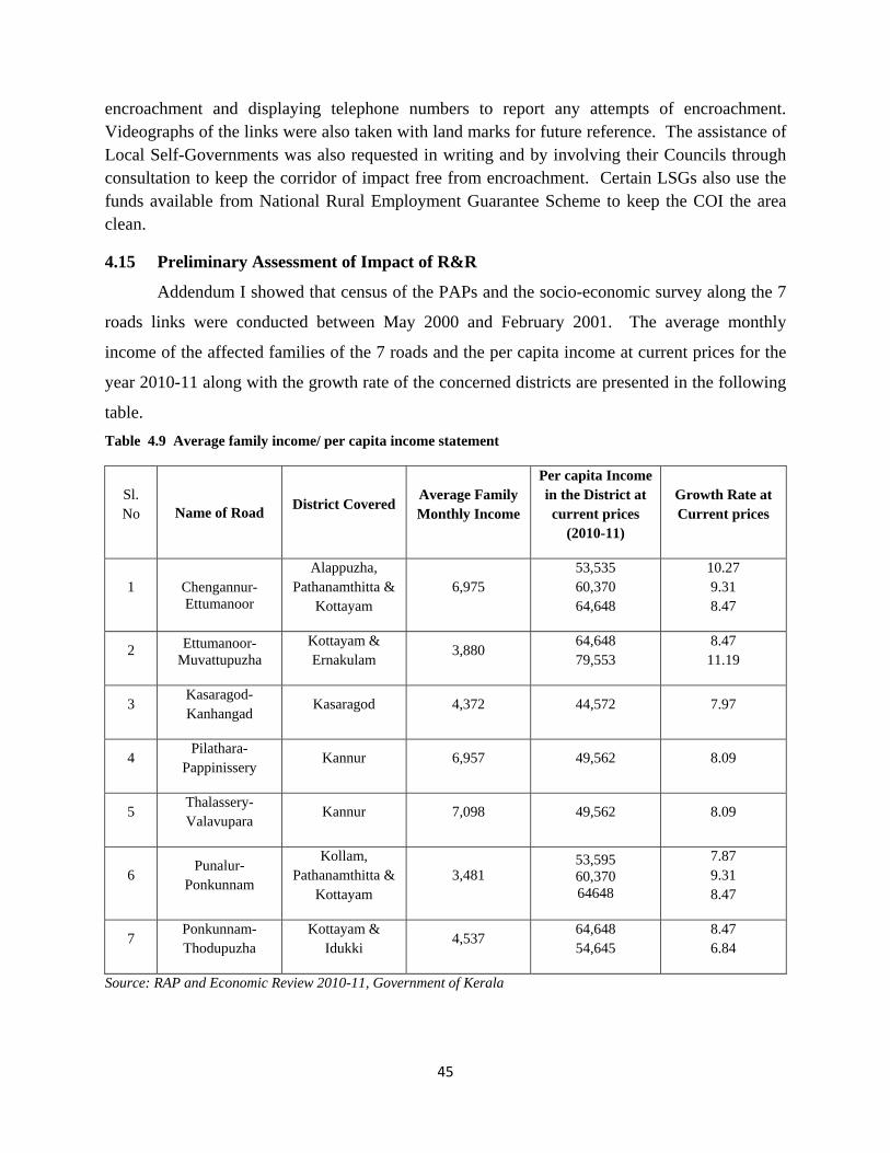
45
encroachment and displaying telephone numbers to report any attempts of encroachment. Videographs of the links were also taken with land marks for future reference. The assistance of Local Self-Governments was also requested in writing and by involving their Councils through consultation to keep the corridor of impact free from encroachment. Certain LSGs also use the funds available from National Rural Employment Guarantee Scheme to keep the COI the area clean.
4.15 Preliminary Assessment of Impact of R&R
Addendum I showed that census of the PAPs and the socio-economic survey along the 7
roads links were conducted between May 2000 and February 2001. The average monthly
income of the affected families of the 7 roads and the per capita income at current prices for the
year 2010-11 along with the growth rate of the concerned districts are presented in the following
table. Table 4.9 Average family income/ per capita income statement
Sl. No Name of Road District Covered
Average Family Monthly Income
Per capita Income in the District at current prices
(2010-11)
Growth Rate at Current prices
1 Chengannur- Ettumanoor
Alappuzha, Pathanamthitta &
Kottayam 6,975
53,535 60,370 64,648
10.27 9.31 8.47
2 Ettumanoor- Muvattupuzha
Kottayam & Ernakulam
3,880 64,648 79,553
8.47 11.19
3 Kasaragod-Kanhangad
Kasaragod 4,372 44,572 7.97
4 Pilathara-
Pappinissery Kannur 6,957 49,562 8.09
5 Thalassery-Valavupara
Kannur 7,098 49,562 8.09
6 Punalur-
Ponkunnam
Kollam, Pathanamthitta &
Kottayam 3,481
53,595 60,370 64648
7.87 9.31 8.47
7 Ponkunnam-Thodupuzha
Kottayam & Idukki
4,537 64,648 54,645
8.47 6.84
Source: RAP and Economic Review 2010-11, Government of Kerala
46
The information in Table 4.9 when linked with the findings of the terminal evaluation of
KSTP, it can be affirmed that implementation of R&R Policy enabled the project to achieve the
objectives of Operational Policy 4.12 of The World Bank (2002). It assisted displaced persons to
improve their livelihoods and standards of living in real terms, to pre-displacement.
The terminal evaluation appreciated positive changes in the living standards of the project
affected families in the post-displacement period. 66% of the families belonged to forward
communities while 1.34% consisted of scheduled castes (SC) and the remaining 32.66%
belonged to other backward communities (OBC). There has not been any major shift in the
previous occupation but identified a slight decrease in the farm labour which is in line with the
general trend in Kerala, a shift from the agriculture to service sector.
There has been a very significant positive change in the resource and asset base of the
PAFs who acquired durable domestic assets. Among the displaced, majority demonstrated
upward mobility which showed 13% increase in pucca (permanent) structures which was directly
linked with the decrease in kutcha (shackle) and semi-pucca structures. Other amenities
accessed by the PAFs/PDFs were, drinking water, electric connection and cooking gas showing a
shift from firewood by 4.4%. The evaluation also found that the displaced families could retain
their income levels and some could improve their household income due to productive use of
R&R assistance. The new structures that have come up along the project roads after the
acquisition tells the tale of the upward movement of PAPs in social status, asset acquisition and
utilization of compensation and assistance towards development.
4.16 Budget and the Expenditure
Addendum I provided an estimate for each package to cover land acquisition, resettlement and rehabilitation. In the context of the increased extent of required land and the number of affected families, it is quite natural that the budget provisions happened to be under estimated. However, an effort is made to consolidate the payments made under various categories as compensation and R&R assistance and provide a comparison. Provision has also been made for the pending payments related to the 3.46 hectares of land as lump sum to cover cost of land and R&R assistances.
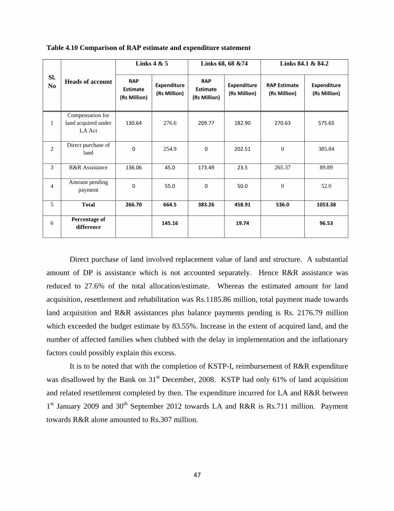
47
Table 4.10 Comparison of RAP estimate and expenditure statement
Sl. No
Heads of account
Links 4 & 5 Links 68, 68 &74 Links 84.1 & 84.2
RAP Estimate
(Rs Million)
Expenditure (Rs Million)
RAP Estimate
(Rs Million)
Expenditure (Rs Million)
RAP Estimate (Rs Million)
Expenditure (Rs Million)
1 Compensation for
land acquired under LA Act
130.64 276.6 209.77 182.90 270.63 575.65
2 Direct purchase of
land 0 254.9 0 202.51 0 385.84
3 R&R Assistance 136.06 45.0 173.49 23.5 265.37 89.89
4 Amount pending
payment 0 55.0 0 50.0 0 52.0
5 Total 266.70 664.5 383.26 458.91 536.0 1053.38
6 Percentage of difference
145.16 19.74 96.53
Direct purchase of land involved replacement value of land and structure. A substantial
amount of DP is assistance which is not accounted separately. Hence R&R assistance was
reduced to 27.6% of the total allocation/estimate. Whereas the estimated amount for land
acquisition, resettlement and rehabilitation was Rs.1185.86 million, total payment made towards
land acquisition and R&R assistances plus balance payments pending is Rs. 2176.79 million
which exceeded the budget estimate by 83.55%. Increase in the extent of acquired land, and the
number of affected families when clubbed with the delay in implementation and the inflationary
factors could possibly explain this excess.
It is to be noted that with the completion of KSTP-I, reimbursement of R&R expenditure
was disallowed by the Bank on 31st December, 2008. KSTP had only 61% of land acquisition
and related resettlement completed by then. The expenditure incurred for LA and R&R between
1st January 2009 and 30th September 2012 towards LA and R&R is Rs.711 million. Payment
towards R&R alone amounted to Rs.307 million.
48
CHAPTER V
ACTION PLAN TO COMPLETE IMPLEMENTATION OF R&R POLICY
(Link 41&47 and balance activities of 7 Links)
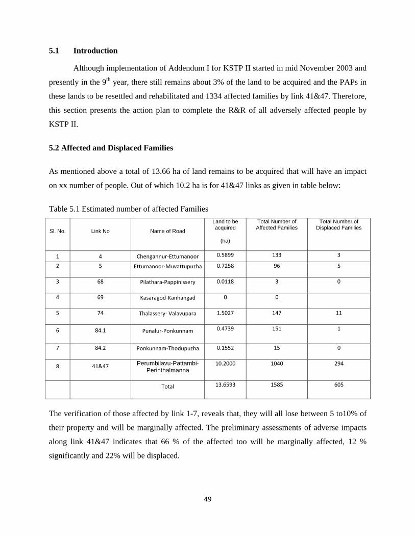
49
5.1 Introduction
Although implementation of Addendum I for KSTP II started in mid November 2003 and
presently in the 9th year, there still remains about 3% of the land to be acquired and the PAPs in
these lands to be resettled and rehabilitated and 1334 affected families by link 41&47. Therefore,
this section presents the action plan to complete the R&R of all adversely affected people by
KSTP II.
5.2 Affected and Displaced Families
As mentioned above a total of 13.66 ha of land remains to be acquired that will have an impact
on xx number of people. Out of which 10.2 ha is for 41&47 links as given in table below:
Table 5.1 Estimated number of affected Families
Sl. No. Link No Name of Road
Land to be acquired
(ha)
Total Number of Affected Families
Total Number of Displaced Families
1 4 Chengannur‐Ettumanoor 0.5899 133 3
2 5 Ettumanoor‐Muvattupuzha 0.7258 96 5
3 68 Pilathara‐Pappinissery 0.0118 3 0
4 69 Kasaragod‐Kanhangad 0 0
5 74 Thalassery‐ Valavupara 1.5027 147 11
6 84.1 Punalur‐Ponkunnam 0.4739 151 1
7 84.2 Ponkunnam‐Thodupuzha 0.1552 15 0
8 41&47 Perumbilavu-Pattambi-Perinthalmanna
10.2000 1040 294
Total 13.6593 1585 605
The verification of those affected by link 1-7, reveals that, they will all lose between 5 to10% of
their property and will be marginally affected. The preliminary assessments of adverse impacts
along link 41&47 indicates that 66 % of the affected too will be marginally affected, 12 %
significantly and 22% will be displaced.
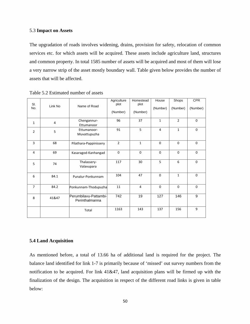
50
5.3 Impact on Assets
The upgradation of roads involves widening, drains, provision for safety, relocation of common
services etc. for which assets will be acquired. These assets include agriculture land, structures
and common property. In total 1585 number of assets will be acquired and most of them will lose
a very narrow strip of the asset mostly boundary wall. Table given below provides the number of
assets that will be affected.
Table 5.2 Estimated number of assets
Sl. No. Link No Name of Road
Agriculture plot
(Number)
Homestead plot
(Number)
House
(Number)
Shops
(Number)
CPR
(Number)
1 4 Chengannur‐Ettumanoor
96 37 1 2 0
2 5 Ettumanoor‐Muvattupuzha
91 5 4 1 0
3 68 Pilathara‐Pappinissery 2 1 0 0 0
4 69 Kasaragod‐Kanhangad 0 0 0 0 0
5 74 Thalassery‐ Valavupara
117 30 5 6 0
6 84.1 Punalur‐Ponkunnam 104 47 0 1 0
7 84.2 Ponkunnam‐Thodupuzha 11 4 0 0 0
8 41&47 Perumbilavu-Pattambi-Perinthalmanna
742 19 127 146 9
Total 1163 143 137 156 9
5.4 Land Acquisition
As mentioned before, a total of 13.66 ha of additional land is required for the project. The
balance land identified for link 1-7 is primarily because of ‘missed’ out survey numbers from the
notification to be acquired. For link 41&47, land acquisition plans will be firmed up with the
finalization of the design. The acquisition in respect of the different road links is given in table
below:
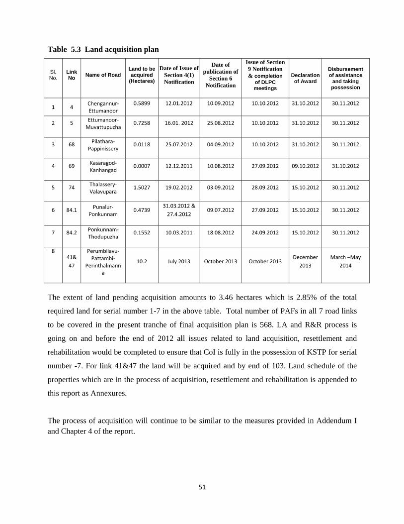
51
Table 5.3 Land acquisition plan
Sl. No.
Link No Name of Road
Land to be acquired
(Hectares)
Date of Issue of Section 4(1) Notification
Date of publication of
Section 6 Notification
Issue of Section 9 Notification & completion
of DLPC meetings
Declaration of Award
Disbursement of assistance
and taking possession
1 4 Chengannur‐Ettumanoor
0.5899 12.01.2012 10.09.2012 10.10.2012 31.10.2012 30.11.2012
2 5 Ettumanoor‐Muvattupuzha
0.7258 16.01. 2012 25.08.2012 10.10.2012 31.10.2012 30.11.2012
3 68 Pilathara‐Pappinissery
0.0118 25.07.2012 04.09.2012 10.10.2012 31.10.2012 30.11.2012
4 69 Kasaragod‐Kanhangad
0.0007 12.12.2011 10.08.2012 27.09.2012 09.10.2012 31.10.2012
5 74 Thalassery‐ Valavupara
1.5027 19.02.2012 03.09.2012 28.09.2012 15.10.2012 30.11.2012
6 84.1 Punalur‐Ponkunnam
0.4739 31.03.2012 & 27.4.2012
09.07.2012 27.09.2012 15.10.2012 30.11.2012
7 84.2 Ponkunnam‐Thodupuzha
0.1552 10.03.2011 18.08.2012 24.09.2012 15.10.2012 30.11.2012
8 41&47
Perumbilavu‐Pattambi‐
Perinthalmanna
10.2 July 2013 October 2013 October 2013 December
2013 March –May
2014
The extent of land pending acquisition amounts to 3.46 hectares which is 2.85% of the total
required land for serial number 1-7 in the above table. Total number of PAFs in all 7 road links
to be covered in the present tranche of final acquisition plan is 568. LA and R&R process is
going on and before the end of 2012 all issues related to land acquisition, resettlement and
rehabilitation would be completed to ensure that CoI is fully in the possession of KSTP for serial
number -7. For link 41&47 the land will be acquired and by end of 103. Land schedule of the
properties which are in the process of acquisition, resettlement and rehabilitation is appended to
this report as Annexures.
The process of acquisition will continue to be similar to the measures provided in Addendum I and Chapter 4 of the report.
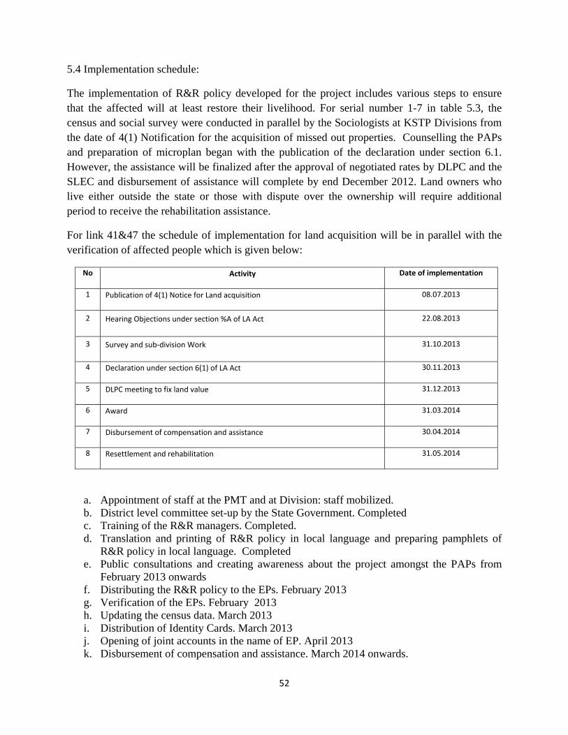
52
5.4 Implementation schedule:
The implementation of R&R policy developed for the project includes various steps to ensure that the affected will at least restore their livelihood. For serial number 1-7 in table 5.3, the census and social survey were conducted in parallel by the Sociologists at KSTP Divisions from the date of 4(1) Notification for the acquisition of missed out properties. Counselling the PAPs and preparation of microplan began with the publication of the declaration under section 6.1. However, the assistance will be finalized after the approval of negotiated rates by DLPC and the SLEC and disbursement of assistance will complete by end December 2012. Land owners who live either outside the state or those with dispute over the ownership will require additional period to receive the rehabilitation assistance.
For link 41&47 the schedule of implementation for land acquisition will be in parallel with the verification of affected people which is given below:
No Activity Date of implementation
1 Publication of 4(1) Notice for Land acquisition 08.07.2013
2 Hearing Objections under section %A of LA Act 22.08.2013
3 Survey and sub‐division Work 31.10.2013
4 Declaration under section 6(1) of LA Act 30.11.2013
5 DLPC meeting to fix land value 31.12.2013
6 Award 31.03.2014
7 Disbursement of compensation and assistance 30.04.2014
8 Resettlement and rehabilitation 31.05.2014
a. Appointment of staff at the PMT and at Division: staff mobilized. b. District level committee set-up by the State Government. Completed c. Training of the R&R managers. Completed. d. Translation and printing of R&R policy in local language and preparing pamphlets of
R&R policy in local language. Completed e. Public consultations and creating awareness about the project amongst the PAPs from
February 2013 onwards f. Distributing the R&R policy to the EPs. February 2013 g. Verification of the EPs. February 2013 h. Updating the census data. March 2013 i. Distribution of Identity Cards. March 2013 j. Opening of joint accounts in the name of EP. April 2013 k. Disbursement of compensation and assistance. March 2014 onwards.
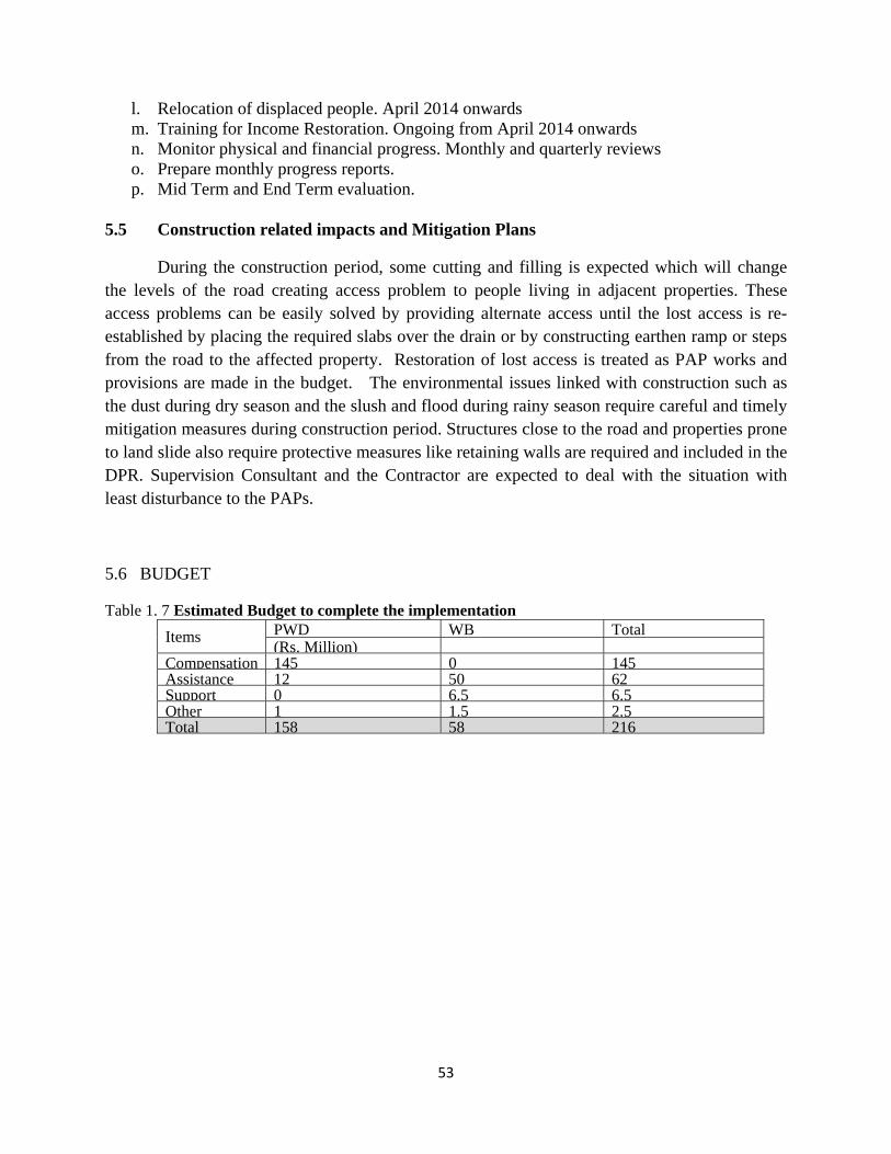
53
l. Relocation of displaced people. April 2014 onwards m. Training for Income Restoration. Ongoing from April 2014 onwards n. Monitor physical and financial progress. Monthly and quarterly reviews o. Prepare monthly progress reports. p. Mid Term and End Term evaluation.
5.5 Construction related impacts and Mitigation Plans
During the construction period, some cutting and filling is expected which will change the levels of the road creating access problem to people living in adjacent properties. These access problems can be easily solved by providing alternate access until the lost access is re-established by placing the required slabs over the drain or by constructing earthen ramp or steps from the road to the affected property. Restoration of lost access is treated as PAP works and provisions are made in the budget. The environmental issues linked with construction such as the dust during dry season and the slush and flood during rainy season require careful and timely mitigation measures during construction period. Structures close to the road and properties prone to land slide also require protective measures like retaining walls are required and included in the DPR. Supervision Consultant and the Contractor are expected to deal with the situation with least disturbance to the PAPs.
5.6 BUDGET
Table 1. 7 Estimated Budget to complete the implementation
Items PWD WB Total (Rs. Million)
Compensation 145 0 145 Assistance 12 50 62 Support 0 6.5 6.5 Other 1 1.5 2.5 Total 158 58 216
Executive Summary Page 1
Overview 1. The Government of Kerala (GOK) while preparing the Kerala State Transport Project (KSTP) in
2000 with assistance from the World Bank, engaged Project Coordinating Consultants (PCC) to
identify 600 km from the 2810 km of priority roads for upgadation. The Strategic Option Study
identified 581 kms of roads for upgradation and 1000 kms of roads for heavy maintenance to be
taken up for construction in two phases. Due to several reasons including delay in land
acquisition, only 254 km of Phase I road was upgraded and maintenance works for 1180 km were
carried out from June 2002 to December 2009. Even though civil works on remaining 327 km
for upgradation could not be undertaken, land acquisition and resettlement and rehabilitation of
affected people continued. As a result, the preparation phase of KSTP II coincides with the
implementation of Resettlement Action Plan (RAP) for Phase II roads (Addendum I). In
addition, two more links number 41 and 47 Perumpilalavu-Pattambi and Pattambi-
Perinthalmanna of 41 km are included in the project. Hence this is an Implementation Progress
Report of RAP (Addendum I) and estimates of affected people along the two links 41&47 and an
action plan to implement the balance acitivities.
2. The GOK adopted a Resettlement and Rehabilitation (R&R) Policy for KSTP to address the
adverse impacts arising out of this project. The efficacy of the R&R Policy motivated GOK to
make it applicable to all fast track projects in the stat and after enhancement of monetary
assistance on 15 November 2011, GOK developed a comprehensive state level resettlement and
rehabilitation policy that is applicable to all sectors.
3. As proposed in the Addendum I, institutional mechanisms were established to implement the
RAP. Steering Committee/State Level Empowered Committee decided policy matters while
Project Management Team implemented and monitored the project through KSTP Divisions at
the field level and Land Acquisition units at the district level. District Level Purchase Committees
under the Chairmanship of the District Collector were established to arrive at a land value
through negotiation with the PAPs. Grievance Redressal Committees were also formed at the
district level to redress grievances of PAPs. NGOs were engaged to function as a bridge between
the Project and the PAPs promoting participatory processes in the implementation of RAP.
NGOs conducted census and social survey, public consultation and provided counseling and
educated the PAPs of their entitlements. They prepared microplans through consultative process,
disbursed assistance and helped PAPs to resettle and rehabilitate.
4. The process of implementation of Addendum I involved information sharing and public
consultation and disclosure of documents of KSTP II, census and counseling the entitled persons
Executive Summary Page 2
of their rights and entitlements, issuing identity cards, fixing land value through negotiation with
the entitled persons by the District Level Purchase Committee, preparation of microplans through
participatory process, completion of land acquisition under LA Act or through direct purchase
method, disbursement of compensation and assistance to titleholders and non-titleholders,
grievance redress and monitoring.
5. Date of social survey by the NGO and the notification for acquisition of land under Section 4(1)
of the Land Acquisition Act remained the cutoff date for the non-titleholders and titleholders
respectively.
6. The census data collected between December 2000 and March 2002 showed that a total of 10,857
families would be affected of whom 71% constituted titleholders and the remaining 29% non-
titleholders. However, the verification during implementation of Addendum I revealed 91%
increase in the estimate showing the impacted families of KSTP II as 20696. Whereas over 62%
of these families are marginally affected, the significantly affected families due to partial
demolition of the structures constituted about 22% and the displaced families formed 15.8%. The
overall impacted population by KSTP II is around 103,480 and displaced persons constituted
16,570.
7. Land acquisition proposal in the Addendum I for road widening and other improvements was for
79.05 hectares of private land as well as transfer of 1.09 ha government land to PWD. Land
survey for acquisition process revealed that the required land for upgradation was 121 Ha which
is 52.5% above the estimated extent.
8. It is a known fact that land records are based on surveys carried out few decades ago as a result
land records in the village offices were not up-dated. In the absence of updated or digitalized land
records all survey numbers of the land within the corridor of impact could not be identified. The
Land acquisition notices were issued on the basis of record of rights and excluded plots that were
not listed in the records from the preliminary notices. This led to identification of ‘missing’
survey number. Requisition for land acquisition continued to exclude some survey numbers
leaving gap intermittently across the link. As and when the ‘missing’ plot was identified, the
entire process of land acquisition was initiated, resulting in loss of time that hampered progress.
9. Replacement value of the land being acquired for KSTP II was fixed in consultation with the
Entitled Persons by the District Level Purchase Committee (DLPC) chaired by the District
Collector. This was the most acclaimed process of empowerment in the implementation of R&R
of KSTP. In order to ensure that valuation of property was done objectively and systematically,
KSTP procured the services of Approved Valuers from the Institution of Engineers until KSTP
Executive Summary Page 3
personnel became capable of performing the task. Replacement value as per PWD schedule of
rates without considering age or depreciation was offered for affected structures. Further, PAPs
were permitted to use the salvaged materials of their old structure.
10. KSTP II affected 213 Cultural property resources. In most of the cases the compound wall or
vacant land in the road frontage was affected, sparing the structures. But some ‘hundis’ (money
collection boxes) located on encroached land in the right of way and a few shrines had to be
replaced. KSTP held negotiation with the authorities of these properties and provided for the
mitigation measures including enhancement of benefits as per agreement reached through
negotiation.
11. Total number of grievances received and recorded was 1423 out of which 469 were LA
references forwarded to the Sub Court as per LA Act for enhancement of compensation.
Remaining 954 cases were heard and settled through the Grievance Redressal System of the
project.
12. Socio economic analysis of the PAPs based in Addendum I and the findings of terminal
evaluation by external consultant showed that implementation of R&R Policy enabled the project
to achieve the objectives as conceived in the Operational Directive 4.121 of The World Bank.
KSTP assisted displaced persons to improve their social status, self-esteem, livelihoods and
standards of living in real terms to pre-displacement. Among the displaced, majority
demonstrated upward mobility which showed 13% increase in pucca (permanent) structures
which was directly linked with the decrease in kutcha (shackle) and semi-pucca structures. Other
amenities accessed by the PAFs/PDFs were, drinking water, electric connection and cooking gas
showing a shift from firewood by 4.4%. The evaluation also found that the displaced families
could retain their income levels and some could improve their household income due to
productive use of R&R assistance.
13. Analysis of budget showed an increase in the expenditure by 84% covering land acquisition and
rehabilitation which is justified considering the increase in the acquired land and the delay in
implementation of Addendum I which dates back to 2002. The expenditure of LA and R&R of
KSTP II which includes the balance payment due for 3.5 hectares from 566 persons is Rs.2177
1 The preparation of KSTP was initiated in 2000 and World Bank’s Operational Directive 4.12 was applicable which was replaced with Operational Policy 4.12 in 2002.
Executive Summary Page 4
million. However the amount spent from 1st January 2010 to 30th September 2012 is Rs.711
million of which R&R assistance constituted Rs.307 million.
14. The process is on-going for land acquisition along the 7 links where implementation was RAP
continued. A balance of 3.46 hectares, which is 2.85% of the total required land, is yet to be
acquired and is pending as on 30th September 2012. LA and R&R process is being implemented
and is likely to complete before the end of 2012 to ensure that corridor of impact is fully in the
possession of project authority. Balance of total number of entitled persons in all 7 road links, to
be supported under R&R policy, is 566 and are in possession of the remaining 2.85% of land to
be acquired. In addition, 1334 number of affected by link 41 & 47 will be resettled and
rehabilitated in accordance with the policy.
15. Although implementation of land acquisition as well as resettlement and rehabilitation was started
in the year 2003 for KSTP II, it could not be completed by the mid year 2012. Missed out survey
numbers of properties from the notification under Section 4(1) of the LA Act was a major
impediment which necessitated subsequent issue of notifications. The remaining is 2.85% of the
total required land for which an action plan is being implemented and will be completed by end
2012. November, 2012. For link 41&47, it proposed to acquire the land by end of 2013.
16. Frequent turnover of project personnel including the Team leader and members of the NGOs, the
Executive Engineers in the field and Land Acquisition Officers further delayed the
implementation of Addendum I.
17. Lessons Learnt
• Whereas land acquisition under LA Act took around three years to complete the process, direct
purchase method introduced by KSTP through negotiation with the land owners, shortened the
duration by half.
• District Level Purchase Committee constituted under the Chairmanship of the District Collector
emerged as a viable institutional arrangement to firm up land value through negotiation with the
land owners in groups. This approach is simulated in other projects and in the new R&R Policy as
well.
• Engaging Approved Valuers from the Institution of Valuers helped KSTP to improve and
enhance the valuation technique.
• Providing replacement value of structures to the affected families including the use of salvaged
materials helped the PAFs build structures of improved quality.
Executive Summary Page 5
• Disclosure of project details and entitlements of PAPs as well as the grievance redressal
mechanism enhanced the transparency of the project.
• Vulnerable category of project affected families and persons required preferential treatment and
special package. It enabled them to improve their livelihood status.
• The Social Cell in development of the project was recognized for effectively managing the
implementation of Addendum I .
Kerala State Transport Project-II Resettlement Action Plan
Louis Berger International/Sheladia Associates/CES/ICT i
Table of Contents
1 PROJECT DESCRIPTION ........................................................................................................ 1
1.1 PROJECT PURPOSE ....................................................................................................................................................... 1 1.2 PROJECT OBJECTIVE AND THE RAP ............................................................................................................................ 1 1.3 ADDITIONAL WORK IN PHASE II FOR THE PHASE I ROADS ..................................................................................... 1 1.4 PROJECT DESCRIPTION ................................................................................................................................................ 2 1.5 DEFINITIONS ................................................................................................................................................................. 5 1.6 METHODOLOGY ............................................................................................................................................................ 6 1.7 IMPACT MINIMISING EFFORTS AND BYPASSES ......................................................................................................... 6 1.8 RESETTLEMENT POLICY ................................................................................................................................................ 7 1.9 THE PARTICIPATORY PROCESS .................................................................................................................................... 7 1.10 LAND ACQUISITION AND RESETTLEMENT ................................................................................................................. 7 1.11 INCOME RESTORATION ................................................................................................................................................ 8 1.12 COMMON PROPERTY RESOURCES .............................................................................................................................. 9 1.13 THE KSTP AND HIV/AIDS......................................................................................................................................... 9 1.14 ROAD SAFETY AND PARKING OF VEHICLES ............................................................................................................... 9 1.15 INSTITUTIONAL ARRANGEMENTS AND PROJECT IMPLEMENTATION ....................................................................... 9 1.16 CONSOLIDATED BUDGET ........................................................................................................................................... 10 1.17 GRIEVANCE REDRESS ................................................................................................................................................. 10 1.18 MONITORING AND EVALUATION ............................................................................................................................. 10 1.19 PUBLIC DISCLOSURE OF THE RAP ............................................................................................................................ 12
2 METHODOLOGY .................................................................................................................. 13
2.1 INTRODUCTION ........................................................................................................................................................... 13 2.2 THE VERIFICATION EXERCISE ..................................................................................................................................... 13 2.3 SURVEYS ...................................................................................................................................................................... 13 2.4 CONSULTATION METHODS ....................................................................................................................................... 16 2.5 STRIP MAPS AND LAND SCHEDULES........................................................................................................................ 17 2.6 LIMITATIONS .......................................................................................................................................................... 18
3 MINIMISING NEGATIVE SOCIAL IMPACT ......................................................................... 19
3.1 INTRODUCTION ........................................................................................................................................................... 19 3.2 OPTIONS CONSIDERED FOR MINIMISING NEGATIVE SOCIAL IMPACTS ............................................................... 19 3.3 RESULTS OF MINIMISING NEGATIVE IMPACTS ........................................................................................................ 23 3.4 MINIMISING RESETTLEMENT ..................................................................................................................................... 25
4 FINDINGS OF THE CENSUS AND SOCIO-ECONOMIC SURVEY RESULTS ........................ 27
4.1 DEMOGRAPHIC PROFILE: AFFECTED POPULATION ................................................................................................. 27 4.2 FAMILY ECONOMY/RESOURCE BASE ....................................................................................................................... 28 4.3 SOCIO-ECONOMIC PROFILE OF THE PAPS.............................................................................................................. 30
5 THE VULNERABLE GROUPS ............................................................................................... 33
5.1 INTRODUCTION ........................................................................................................................................................... 33 5.2 “BELOW POVERTY LINE” (BPL) ................................................................................................................................. 33 5.3 SCHEDULED CASTES (SC) AND SCHEDULED TRIBES (ST) ...................................................................................... 34 5.4 WOMEN HEADED AND OTHER VULNERABLE FAMILIES .......................................................................................... 35 5.5 SOCIAL CHARACTERISTICS OF THE VULNERABLE GROUPS ON THE PROJECT ROADS ........................................ 36 5.6 SQUATTERS ................................................................................................................................................................. 37
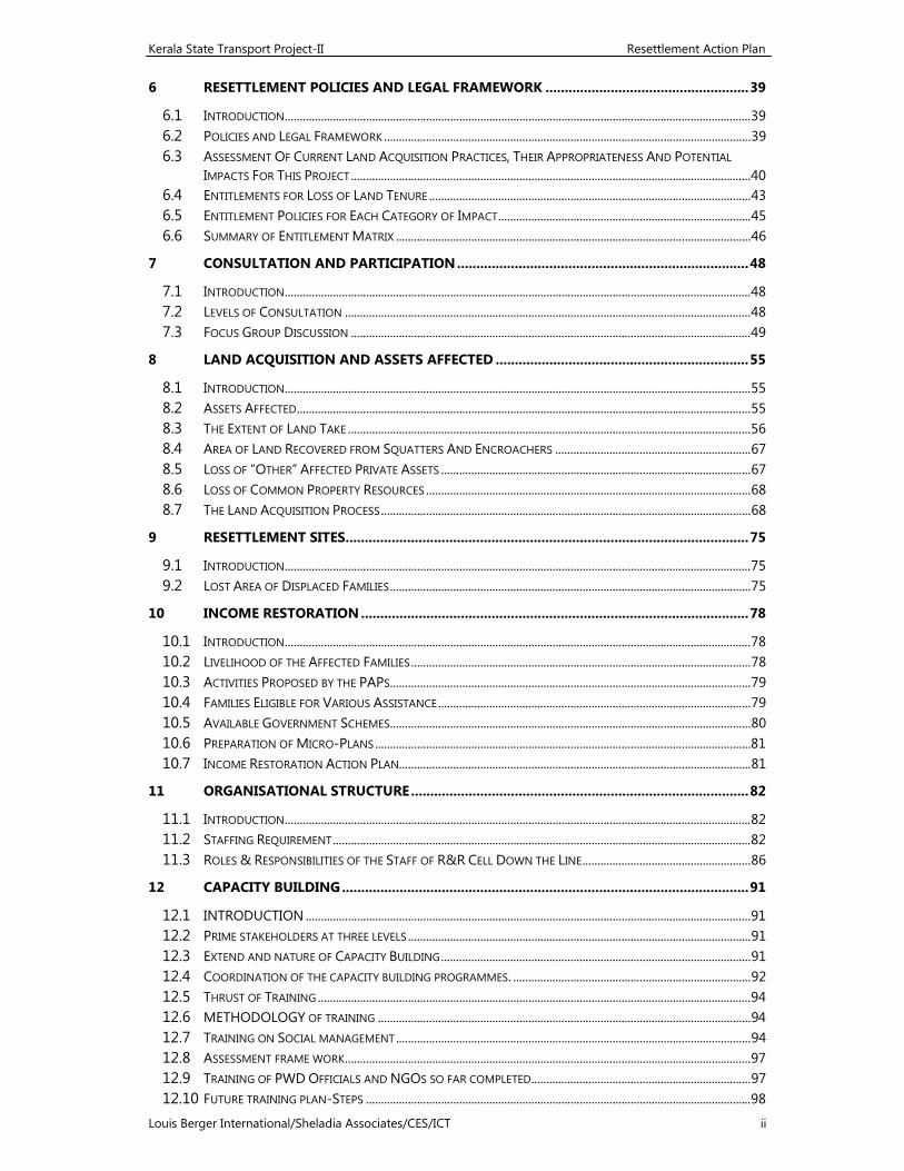
Kerala State Transport Project-II Resettlement Action Plan
Louis Berger International/Sheladia Associates/CES/ICT ii
6 RESETTLEMENT POLICIES AND LEGAL FRAMEWORK ..................................................... 39
6.1 INTRODUCTION ........................................................................................................................................................... 39 6.2 POLICIES AND LEGAL FRAMEWORK .......................................................................................................................... 39 6.3 ASSESSMENT OF CURRENT LAND ACQUISITION PRACTICES, THEIR APPROPRIATENESS AND POTENTIAL
IMPACTS FOR THIS PROJECT ..................................................................................................................................... 40 6.4 ENTITLEMENTS FOR LOSS OF LAND TENURE ........................................................................................................... 43 6.5 ENTITLEMENT POLICIES FOR EACH CATEGORY OF IMPACT .................................................................................... 45 6.6 SUMMARY OF ENTITLEMENT MATRIX ...................................................................................................................... 46
7 CONSULTATION AND PARTICIPATION ............................................................................ 48
7.1 INTRODUCTION ........................................................................................................................................................... 48 7.2 LEVELS OF CONSULTATION ....................................................................................................................................... 48 7.3 FOCUS GROUP DISCUSSION ..................................................................................................................................... 49
8 LAND ACQUISITION AND ASSETS AFFECTED .................................................................. 55
8.1 INTRODUCTION ........................................................................................................................................................... 55 8.2 ASSETS AFFECTED ....................................................................................................................................................... 55 8.3 THE EXTENT OF LAND TAKE ...................................................................................................................................... 56 8.4 AREA OF LAND RECOVERED FROM SQUATTERS AND ENCROACHERS ................................................................. 67 8.5 LOSS OF “OTHER” AFFECTED PRIVATE ASSETS ....................................................................................................... 67 8.6 LOSS OF COMMON PROPERTY RESOURCES ............................................................................................................ 68 8.7 THE LAND ACQUISITION PROCESS ........................................................................................................................... 68
9 RESETTLEMENT SITES ......................................................................................................... 75
9.1 INTRODUCTION ........................................................................................................................................................... 75 9.2 LOST AREA OF DISPLACED FAMILIES ........................................................................................................................ 75
10 INCOME RESTORATION ..................................................................................................... 78
10.1 INTRODUCTION ........................................................................................................................................................... 78 10.2 LIVELIHOOD OF THE AFFECTED FAMILIES ................................................................................................................. 78 10.3 ACTIVITIES PROPOSED BY THE PAPS ........................................................................................................................ 79 10.4 FAMILIES ELIGIBLE FOR VARIOUS ASSISTANCE ........................................................................................................ 79 10.5 AVAILABLE GOVERNMENT SCHEMES........................................................................................................................ 80 10.6 PREPARATION OF MICRO-PLANS ............................................................................................................................. 81 10.7 INCOME RESTORATION ACTION PLAN..................................................................................................................... 81
11 ORGANISATIONAL STRUCTURE ........................................................................................ 82
11.1 INTRODUCTION ........................................................................................................................................................... 82 11.2 STAFFING REQUIREMENT ........................................................................................................................................... 82 11.3 ROLES & RESPONSIBILITIES OF THE STAFF OF R&R CELL DOWN THE LINE ........................................................ 86
12 CAPACITY BUILDING .......................................................................................................... 91
12.1 INTRODUCTION .................................................................................................................................................... 91 12.2 PRIME STAKEHOLDERS AT THREE LEVELS .................................................................................................................. 91 12.3 EXTEND AND NATURE OF CAPACITY BUILDING ....................................................................................................... 91 12.4 COORDINATION OF THE CAPACITY BUILDING PROGRAMMES. ............................................................................... 92 12.5 THRUST OF TRAINING ................................................................................................................................................ 94 12.6 METHODOLOGY OF TRAINING ............................................................................................................................ 94 12.7 TRAINING ON SOCIAL MANAGEMENT ...................................................................................................................... 94 12.8 ASSESSMENT FRAME WORK ....................................................................................................................................... 97 12.9 TRAINING OF PWD OFFICIALS AND NGOS SO FAR COMPLETED......................................................................... 97 12.10 FUTURE TRAINING PLAN-STEPS ................................................................................................................................ 98
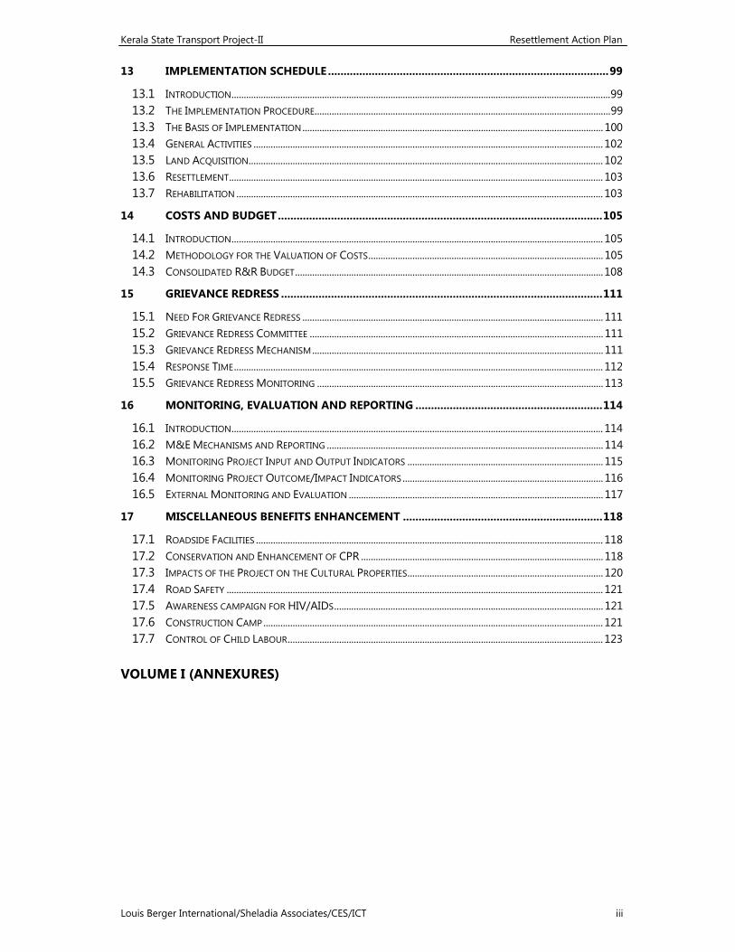
Kerala State Transport Project-II Resettlement Action Plan
Louis Berger International/Sheladia Associates/CES/ICT iii
13 IMPLEMENTATION SCHEDULE .......................................................................................... 99
13.1 INTRODUCTION ........................................................................................................................................................... 99 13.2 THE IMPLEMENTATION PROCEDURE......................................................................................................................... 99 13.3 THE BASIS OF IMPLEMENTATION ........................................................................................................................... 100 13.4 GENERAL ACTIVITIES ............................................................................................................................................... 102 13.5 LAND ACQUISITION ................................................................................................................................................. 102 13.6 RESETTLEMENT ......................................................................................................................................................... 103 13.7 REHABILITATION ...................................................................................................................................................... 103
14 COSTS AND BUDGET ........................................................................................................ 105
14.1 INTRODUCTION ........................................................................................................................................................ 105 14.2 METHODOLOGY FOR THE VALUATION OF COSTS ................................................................................................ 105 14.3 CONSOLIDATED R&R BUDGET .............................................................................................................................. 108
15 GRIEVANCE REDRESS ....................................................................................................... 111
15.1 NEED FOR GRIEVANCE REDRESS ........................................................................................................................... 111 15.2 GRIEVANCE REDRESS COMMITTEE ........................................................................................................................ 111 15.3 GRIEVANCE REDRESS MECHANISM ....................................................................................................................... 111 15.4 RESPONSE TIME ....................................................................................................................................................... 112 15.5 GRIEVANCE REDRESS MONITORING ..................................................................................................................... 113
16 MONITORING, EVALUATION AND REPORTING ............................................................ 114
16.1 INTRODUCTION ........................................................................................................................................................ 114 16.2 M&E MECHANISMS AND REPORTING ................................................................................................................. 114 16.3 MONITORING PROJECT INPUT AND OUTPUT INDICATORS ................................................................................ 115 16.4 MONITORING PROJECT OUTCOME/IMPACT INDICATORS .................................................................................. 116 16.5 EXTERNAL MONITORING AND EVALUATION ........................................................................................................ 117
17 MISCELLANEOUS BENEFITS ENHANCEMENT ................................................................ 118
17.1 ROADSIDE FACILITIES .............................................................................................................................................. 118 17.2 CONSERVATION AND ENHANCEMENT OF CPR ................................................................................................... 118 17.3 IMPACTS OF THE PROJECT ON THE CULTURAL PROPERTIES ................................................................................ 120 17.4 ROAD SAFETY .......................................................................................................................................................... 121 17.5 AWARENESS CAMPAIGN FOR HIV/AIDS .............................................................................................................. 121 17.6 CONSTRUCTION CAMP ........................................................................................................................................... 121 17.7 CONTROL OF CHILD LABOUR ................................................................................................................................. 123
VOLUME I (ANNEXURES)
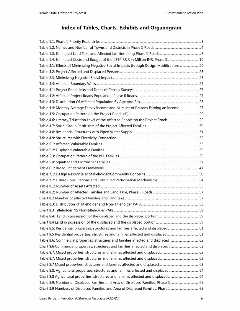
Kerala State Transport Project-II Resettlement Action Plan
Louis Berger International/Sheladia Associates/CES/ICT iv
Index of Tables, Charts, Exhibits and Organogram Table 1.1: Phase II Priority Road Links .............................................................................................................................. 3 Table 1.2: Names and Number of Towns and Districts in Phase II Roads .......................................................... 4 Table 1.3: Estimated Land Take and Affected families along Phase II Roads .................................................... 8 Table 1.4: Estimated Costs and Budget of the KSTP R&R in Million INR, Phase II ........................................ 10 Table 3.1: Effects of Minimizing Negative Social Impacts through Design Modifications ........................ 20 Table 3.2: Project Affected and Displaced Persons ................................................................................................... 23 Table 3.3: Minimizing Negative Social Impact ............................................................................................................. 23 Table 3.4: Affected Boundary Walls ................................................................................................................................. 25 Table 4.1: Project Road Links and Dates of Census Surveys .................................................................................. 27 Table 4.2: Affected Project Roads Population, Phase II Roads .............................................................................. 27 Table 4.3: Distribution Of Affected Population By Age And Sex .......................................................................... 28 Table 4.4: Monthly Average Family Income and Number of Persons Earning an Income ......................... 28 Table 4.5: Occupation Pattern on the Project Roads (%) ........................................................................................ 29 Table 4.6: Literacy/Education Level of the Affected People on the Project Roads ....................................... 29 Table 4.7: Social Group Particulars of the Project Affected Families .................................................................. 30 Table 4.8: Residential Structures with Piped Water Supply .................................................................................... 31 Table 4.9: Structures with Electricity Connection ....................................................................................................... 32 Table 5.1: Affected Vulnerable Families ......................................................................................................................... 35 Table 5.2: Displaced Vulnerable Families ....................................................................................................................... 35 Table 5.3: Occupation Pattern of the BPL Families .................................................................................................... 36 Table 5.4: Squatter and Encroacher Families................................................................................................................ 37 Table 6.1: Broad Entitlement Framework ....................................................................................................................... 47 Table 7.1: Design Response to Stakeholder/Community Concerns ................................................................... 50 Table 7.2: Future Consultations and Continued Participation Mechanisms .................................................... 54 Table 8.1: Number of Assets Affected ............................................................................................................................ 55 Table 8.2: Number of Affected Families and Land Take, Phase II Roads .......................................................... 57 Chart 8.2 Number of affected families and Land take ............................................................................................. 57 Table 8.3: Distribution of Titleholder and Non-Titleholder PAFs ......................................................................... 58 Chart 8.3 Titleholder NS Non-titleholder PAPs ........................................................................................................... 59 Table 8.4: Land in possession of the displaced and the displaced portion .................................................... 59 Chart 8.4 Land in possession of the displaced and the displaced portion ...................................................... 59 Table 8.5: Residential properties, structures and families affected and displaced ....................................... 61 Chart 8.5 Residential properties, structures and families affected and displaced ........................................ 61 Table 8.6: Commercial properties, structures and families affected and displaced ..................................... 62 Chart 8.6 Commercial properties, structures and families affected and displaced ...................................... 62 Table 8.7: Mixed properties, structures and families affected and displaced ................................................. 62 Table 8.7: Mixed properties, structures and families affected and displaced ................................................. 63 Chart 8.7 Mixed properties, structures and families affected and displaced .................................................. 63 Table 8.8: Agricultural properties, structures and families affected and displaced ...................................... 64 Chart 8.8 Agricultural properties, structures and families affected and displaced ....................................... 64 Table 8.9: Number of Displaced Families and Area of Displaced Families, Phase II ..................................... 65 Chart 8.9 Numbers of Displaced Families and Area of Displaced Families, Phase II .................................... 65
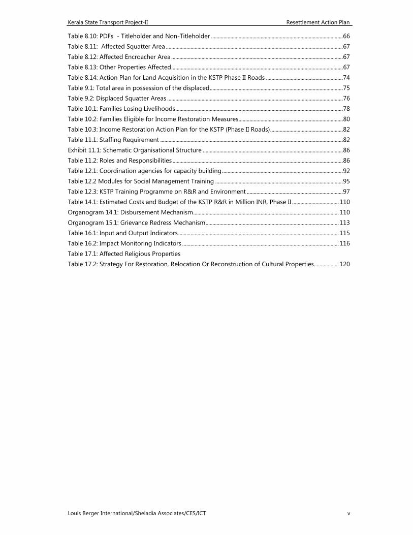
Kerala State Transport Project-II Resettlement Action Plan
Louis Berger International/Sheladia Associates/CES/ICT v
Table 8.10: PDFs - Titleholder and Non-Titleholder ................................................................................................ 66 Table 8.11: Affected Squatter Area ................................................................................................................................. 67 Table 8.12: Affected Encroacher Area ............................................................................................................................. 67 Table 8.13: Other Properties Affected ............................................................................................................................. 67 Table 8.14: Action Plan for Land Acquisition in the KSTP Phase II Roads ........................................................ 74 Table 9.1: Total area in possession of the displaced ................................................................................................. 75 Table 9.2: Displaced Squatter Areas ................................................................................................................................ 76 Table 10.1: Families Losing Livelihoods .......................................................................................................................... 78 Table 10.2: Families Eligible for Income Restoration Measures ............................................................................ 80 Table 10.3: Income Restoration Action Plan for the KSTP (Phase II Roads) ..................................................... 82 Table 11.1: Staffing Requirement ..................................................................................................................................... 82 Exhibit 11.1: Schematic Organisational Structure ...................................................................................................... 86 Table 11.2: Roles and Responsibilities ............................................................................................................................ 86 Table 12.1: Coordination agencies for capacity building ........................................................................................ 92 Table 12.2 Modules for Social Management Training ............................................................................................. 95 Table 12.3: KSTP Training Programme on R&R and Environment ...................................................................... 97 Table 14.1: Estimated Costs and Budget of the KSTP R&R in Million INR, Phase II .................................. 110 Organogram 14.1: Disbursement Mechanism .......................................................................................................... 110 Organogram 15.1: Grievance Redress Mechanism ................................................................................................. 113 Table 16.1: Input and Output Indicators ..................................................................................................................... 115 Table 16.2: Impact Monitoring Indicators .................................................................................................................. 116
Table 17.1: Affected Religious Properties Table 17.2: Strategy For Restoration, Relocation Or Reconstruction of Cultural Properties .................. 120
Kerala State Transport Project-II Resettlement Action Plan
Louis Berger International/Sheladia Associates/CES/ICT vi
Acronyms
BOQ Bill of Quantity BPL Below Poverty Line COI Corridor of Impact CPR Common Property Resources EIA Environmental Impact Assessment EMP Environmental Management Plan EP Entitled Person ESC Environmental and Social Cell ESMP Environmental and Social Management Plan IAS Indian Administration Service IPDP Indigenous People's Development Plan IRC Indian Roads Congress IRDP Integrated Rural Development Programme KSACS Kerala State AIDS Control Society KSTP Kerala State Transport Project Lin.m. Linear Metre NGO Non-Government Organisation
NITHE National Institute for the Training of Highway Engineers
NTH Non-title holder NTHS Non-title holder shopkeeper OD Operational Directive OP Operational Policy PAP Project Affected Person PAF Project Affected Family PDP Project Displaced Person PDF Project Displaced Family PIU Project Implementation Unit PWD Public Works Department R&R Resettlement and Rehabilitation RAP Resettlement Action Plan RMC Road Maintenance Contract ROW Right of Way SC Scheduled Caste SOS Strategic Option Study Sq m. Square metre ST Scheduled Tribe TH Title holder UNDB United Nations Development Business WB World Bank
Kerala State Transport Project-II Resettlement Action Plan
Louis Berger International/Sheladia Associates/CES/ICT vii
Kerala State Transport Project: Resettlement Action Plan - Phase II
Louis Berger International/Sheladia Associates/CES/ICT 1
1 PROJECT DESCRIPTION
1.1 PROJECT PURPOSE
The Kerala State Transport Project (KSTP) aims to improve the performance of the State’s road transport network by upgrading the road conditions and capacity, together with development of the in-house capabilities of the Kerala State Public Works Department (PWD) to plan, develop and maintain the road network.
The KSTP is implemented in two phases. Phase I involves upgradation of 255 km of state highways and 95 K.m. Inland waterways. Phase II involves upgradation works in 330 Km State Highways, located in 6 discrete sections of road identified in Links 4,5, 68, 69, 74 and 84. Besides these 4 bypass roads and upgradation works in 5 places in the RMC-10 (Link 121) suggested through public consultations during phase-I construction, were also taken up and added to Phase-II construction works.
1.2 PROJECT OBJECTIVE AND THE RAP
The objective of the project is to maximise the benefits to the road users arising from the road rehabilitation programme while minimising the negative social impacts by incorporating the social safety measures. Where large-scale population displacement is unavoidable, a detailed resettlement plan with timetable and budget need to be prepared as the Resettlement Action Plan (RAP). These Resettlement plans should be built around a development strategy and package aimed at improving or at least restoring the economic base for those relocated. More specifically, the social impact objective of the project is to ensure the improvement of the former living standards, income earning capacities and production levels of the project affected persons, or at least to help maintain their previous standards of living, as well as to reduce the high road accident rates in the State. The Resettlement Action Plan (RAP) is a report to address these issues .It is compiled in 3 volumes. The first volume consists of the main interpretations for the RAP, detailed in 16 chapters along with 3 Annexures (Annexure, 4 , 5 and 6) . Volume 2 consists or attachments including the stratified land schedules. Volume 3 consists of Land schedules pertaining to all roads in phase .2 ,
The RAP complies with the World Bank directives (Operational Directive 4.30: Involuntary Resettlement and Operational Directive 4.20: Indigenous Peoples) and the Government of Kerala requirements. This RAP relates to the Phase II roads of the KSTP. The RAP for the Phase I roads is currently being implemented.
The modifications suggested by the World Bank in Aide-memoire (November 09-20.2003), reviewing the draft RAP was incorporated in this final RAP
1.3 ADDITIONAL WORK IN PHASE II FOR THE PHASE I ROADS
As the Phase I project implementation works were initiated, people’s representatives in many areas came up with requests to construct bypasses in their respective towns. Adoor, Pala and Thiruvalla bypasses were proposed strongly by local leaders. Similarly the local PWD at Muvattupuzha (for Link 70: Muvattupuzha-Thodupuzha, Phase I road) came up with a proposal for a 3 km-long bypass to connect Link 70 with Link 84.5-7 (Ponkunnam-Thodupuzha) of the Phase II roads. The intention was
Kerala State Transport Project: Resettlement Action Plan - Phase II
Louis Berger International/Sheladia Associates/CES/ICT 2
to fit the existing local level PWD plans with the KSTP to broad base the reach of the project, as they have already built a bridge over the Thodupuzha River, waiting to be connected by a road.
In the RMC-10, Thaliparambu-Iritty (SH-36) KSTP road under the first year maintenance programme, as the contractor, M/s Chandragiri Construction Company, started work, people complained of two low-lying sections, Chengalai (chainage 0.000-1.929) and Sreekandapuram (chainage 0.00-0.738), which get flooded and the late rains in September 2002 totally flooded these sections. Moreover, another section at Nilamattom (chainage 0.000-0.296) has a 150 years old bridge, which is in a very bad condition, needing replacement. A fourth section at Thanithode (chainage 0.000-0.540) and a fifth section at Irikkur (chainage) too needs upgradation works. The local people made representations to the KSTP for upgrading these portions of the road. After discussing the matter with the World Bank, the KSTP decided to upgrade these 5 sections covering approximately 3.5 km in total length, while the remaining length would be under the maintenance programme. (RAP for this portion will be separately presented as a Phase II RAP Supplement, as Engineering surveys for the additional work are in progress, to be followed by the social surveys and analysis.
The Aide Memoire of the Bank’s supervision mission in November 2002 noted (Clause No. 72) that the RAP for the Phase II roads would include a few additional stretches of roads under the Phase I programme, viz., (a) a 2.5 km minor realignment at Adur, Link 2 (to be constructed as a part of Phase I, Contract Package 1), and (b) about 3 km of upgrading works to be carried out in RMC-10, Thaliparambu-Iritty under the First Year Maintenance Programme (to be constructed as a part of Phase II, Contract Package 5, Link No. 74: Thalaserry - Valavupara). In addition, there have been proposals for minor deviations on Link 69: Kasaragod-Kanhangad and Link 74: Thalaserry - Valavupara, both of the Phase II roads.
1.4 PROJECT DESCRIPTION
The Government of Kerala has obtained a loan (Loan No. 4653-IN) from the World Bank (WB or the Bank) for the Kerala State Transport Project. Along with the highways component, the project has a pilot waterways component. The Kerala State PWD is the executing agency for the project. The Phase I activities, including three contract packages for the highways and one contract package for the waterways, are currently being implemented. This infrastructure development is expected to encourage investment in the State’s industrial development.
As indicated above, the project is divided between Phase II and I. Phase I comprises approximately 255 km roads and Phase II ,319 km. The Phase II now has an additional length of 2.14 km for the Adur Bypass of Phase I. In addition, there is a road maintenance component for roads that are not part of the road improvement programme. The total length of such roads is 1,010 km. The maintenance activity will be completed over a period of three years. The maintenance roads have been separately dealt with in the report Environmental and Social Management Plan for the Maintenance Road (January 2002).
Kerala State Transport Project: Resettlement Action Plan - Phase II
Louis Berger International/Sheladia Associates/CES/ICT 3
1.4.1 The Kerala Roadside
An important characteristic of Kerala is that heavily built up areas surround most of the roads. The project affected population in Kerala is educated and generally of middle class base. Rapid urbanization through ribbon development has been a common feature here. The built up areas along the road links consist of expensive pucca, that is, permanent, structures. This scenario contributes to the complexity in upgrading and widening the roads without causing negative social impacts.
In addition, the State itself being a narrow strip of land does not provide land beyond the existing narrow corridor of roads. A typical Kerala road does not have width more than 10-12 metres. In such a scenario, the road upgrading activities will cause people to lose productive land, house plots, buildings, wells, trees or other assets, or lose their income, thus giving rise to negative social impacts. The RAP addresses these issues to resettle and rehabilitate the affected families.
1.4.2 Project Location
The project is upgrading roads in 12 of the 14 districts of the State (Map 1.1). The Phase II roads of approximately 319 km length are spread over the following 8 districts.
Kollam Alappuzha Idukki Kannur
Pathanamthitta Kottayam Ernakulam Kasaragod
1.4.3 Indigenous People’s Development Plan
The KSTP road improvement and maintenance activities are limited to the existing roads. As no incursion is made into any new area, no area with defined indigenous populations has been affected. Therefore, a separate Indigenous People’s Development Plan (IPDP), as mandated in the Bank’s OD 4.20 has not been attempted. The social surveys identified six tribal families, one each on Links 5 and 74 and four on Link 84.5-7, as project affected families, conducting their livelihoods in the road’s ribbon development area along with non-tribal families and the matter has been dealt with according to the project’s R&R Policy.
1.4.4 Selection of Project Roads
Seven road Links, 326.27 km in length, passing through 8 districts, make up the three Contract Packages (5, 6 and 7) in Phase II. In addition, Adur Bypass of Links 2+3 of Phase I roads are also included, as referred to above in Section 1.3. The three Phase II bypasses are also indicated. The bypasses have been identified with a <.x> following the link number. These are presented in Table 1.1 and shown in Map 1.1. The individual road links are marked in square boxes in the map. Table 1.1: Phase II Priority Road Links
Sl. No. Link No. Road CodeRoute Length
(km)
Proposed Carriageway Width (m) From To
Package 5: 1 68 NK-3 Pilathara - Pappinssery 21.00 7.0 2 69 NSH-18 Kasargode - Kanhangad 24.00 7.0 3 74 SH-31 Thalasery – Valuvapara 53.78 7.0
Kerala State Transport Project: Resettlement Action Plan - Phase II
Louis Berger International/Sheladia Associates/CES/ICT 4
Sl. No. Link No. Road CodeRoute Length
(km)
Proposed Carriageway Width (m) From To
Package 6: 4 3.x SH-1 Adur Bypass (Phase I) 2.14 10.0 5 4 SH-1 Chenganur - Ettumanoor 47.00 10.0 6 4.x SH-1 Thiruvalla Bypass 2.28 10.07 5 SH-1 Ettumanoor - Muvattupuzha 40.90 7.0
Package 7: 8 84.1-84.4 SH-8 Punalur - Ponkunnam 82.12 7.09 84.5-84.8 SH-8 Ponkunnam - Thodupuzha 50.10 7.0
10 84.5-7.x SH-8 Pala Bypass 01.06 7.0 11 84. 1.x SH-8 Thodupuzha Bypass 02.67 7.0
Total Length: 326.27
Based on the proposed carriageway width as shown in the table, the proposed corridor width varies from 12 to 15 metres and more depending on the topography of the land and the needs of the road design, including road safety norms. The proposed corridor widths are parts of the engineering design reports, measured for a cross section at every 50 metres. This RAP presents the corridor widths for the Phase II roads at every 250 metres in Annex 8.1. All the roads have been selected on the basis of the Feasibility Study Report Recommendations and Conclusions of April 2000. The recommendations considered road inventory data, traffic surveys, the EIRR (Economic Internal Rate of Return), relative importance of the roads, environmental considerations and otherwise the social significance of the roads, such as the Sabarimala Road (Link 84), which leads to the pilgrimage centre of the Sabarimala Temple.
The Phase II project roads pass through 86 villages and 18 towns of the 8 project districts. The following table shows the names of the towns and districts against the respective road links. The link-wise details of all the villages, with information of to and from chainage of the road link passing through a given village, has been presented in Annex 1.1.
Table 1.2: Names and Number of Towns and Districts in Phase II Roads
Links Village
s Number and Names of Towns Number and Names of Districts
4 16 5 Chengannur, Thiruvalla, Changanaserry, Kottayam, Ettumanoor 3
Alappuzha, Pathanamthitta, Kottayam
5 10 2 Ettumanoor, Muvattupuzha 2 Kottayam, Ernakulam 68 7 2 Pilathara, Pappinssery 1 Kannur 69 8 3 Kasargode, Kanhangad 1 Kasaragod 74 12 2 Thalaserry, Valavupara 1 Kannur 84.1-4 20 1 Punalur, Ponkunnam 3 Kollam, Pathanamthitta, Kottayam84.5-7 13 3 Ponkunnam, Thodupuzha 2 Kottayam, Idukki
Total 86 18 8
Kerala State Transport Project: Resettlement Action Plan - Phase II
Louis Berger International/Sheladia Associates/CES/ICT 5
1.5 DEFINITIONS
1.5.1 Right of Way versus Corridor of Impact
The right of way (ROW) is public land under the control of the PWD and is usually defined as that area over which the public has unhindered access. The corridor of impact is a part of the right of way and sometimes is synonymous with the right of way.
The corridor of impact (COI) is the width required for the actual construction of the road, including the new pavements, footpaths, shoulders, support slopes, embankments, drainage, and necessary safety zones. Within this corridor, there should be no structure or hindrance. The COI is, thus, the area that will be impacted by the proposed project.
1.5.2 Family
The KSTP has adopted “family” as the unit for compensation entitlement purpose. In this sense, every “family” is an entitled person (EP). The R&R Principles and Policy document of the project (Annex 6) defines family in three ways for this purpose:
A "Family" shall mean husband/wife and minor children. Every son or unmarried daughter above the age of 18 years on or before the cut-
off-date will be treated as separate family. Every divorced or widowed daughter living with the family on or prior to cut off
date will be treated as separate family.
1.5.3 Urban and Rural Areas
Following the Indian Government tradition of identifying an area as urban or rural, the social impact surveys also identified places as rural or urban. By “rural population” is generally meant the population living in villages. A village follows the limits of a revenue village, which is recognized by the district administration.
In Kerala a village has little resemblance to the characteristics of a village, as they are urbanized and are not isolated patches of habitation. Especially in the past twenty years many people from the State immigrated to West Asia (also known as the Middle East) for livelihoods. As a result, the urban - rural divide in Kerala, is very thin. The official divide for the urban area (a town or a city) and rural area in the census is based on the local administration as a municipality/ corporation or Panchayat1.
1.5.4 Cut-off Date
The date of the social survey on a given road link is the cut off date for that link to determine the R&R assistance entitlement of the non-titleholders of property, who include tenants and squatters. This has been described in Section 4.
1 A panchayat is the lowest level of administration in India. It is an elected local self-governing
body, which actually means an association of five persons, usually village elders.
Kerala State Transport Project: Resettlement Action Plan - Phase II
Louis Berger International/Sheladia Associates/CES/ICT 6
1.6 METHODOLOGY
This Report is based on the reconnaissance level social impact surveys, detailed social impact surveys including the census of the project affected persons (PAP) and the sample socio-economic baseline surveys, the Social Impact Assessment Report, the Feasibility Study Report, and public consultations.
The primary data were collected with the help of structured questionnaires and complemented by consultations, both individual and group, with the PAPs and other stakeholders. The consultations have influenced the engineering design parameters to a large extent and have helped to minimise the negative social impacts.
The social impact surveyors interviewed the family members /owners of the properties (residential, commercial and agricultural) that were shown as affected in the preliminary engineering design. While every person in the commercial buildings were enlisted as a “family” as indicated in 1.4.2, the number of families in the residential buildings was derived based on their age and marital status for the purpose of entitlement.
1.7 IMPACT MINIMISING EFFORTS AND BYPASSES
As private land acquisition is unavoidable in the KSTP, a number of measures have been taken to minimise land take and the displacement of people. While preparing the project, emphasis was put on minimising the impacts within the limitations of technical feasibility and cost effectiveness. The options considered for minimising negative social impacts included design considerations, public consultations and aggrieved people’s representations, and analysis of alternative, including two short bypasses (“deviations”) to bypass the congested Thiruvalla town on Link 4 (2.28 km) and Pala town on Link 84.5-7 (1.08 km). In addition, bypasses for Adur town of Links 2+3 (Phase I) and Thodupuzha (Link 70: Muvattupuzha-Thodupuzha, Phase I road) has been included in Phase II.
Design considerations included footpaths over drains, useful to minimise the negative social impact with regard to both land take and road safety. In Junction designs, especially which purported for a smooth traffic flow and safe driving, has taken care not to acquire additional land. The proposed bypasses helped to reduce the number of buildings to be affected,minimising displacement of people.
Vulnerable Groups
The KSTP defines vulnerable group as those earning up to 25% above the officially recognised “below poverty line” (BPL). The BPL is determined by a survey conducted by the Rural Development Department of the respective State Governments, popularly known as the IRDP (Integrated Rural Development Programme) Survey. The BPL in Kerala currently stands at Rs. 21000 per annum for a family of five members in the rural areas. Usually, the vulnerable groups may include but are not limited to the following categories of persons:
Kerala State Transport Project: Resettlement Action Plan - Phase II
Louis Berger International/Sheladia Associates/CES/ICT 7
Poor or landless people falling under the “below poverty line” category; Members of the Scheduled Castes (SC) and Scheduled Tribes (ST); Women headed households (WH); Orphans or destitute persons (socially handicapped); and Disabled persons (physically or mentally challenged).
1.8 RESETTLEMENT POLICY
Anticipating adverse impacts of the project on the people living and earning livelihoods along the project roads, the KSTP prepared a project specific Resettlement &Rehabilitation Principles and Policy Framework which was approved by the State Cabinet in August 2000. The Policy recognises three broad types of entitlement:
1. Entitlement for project affected families
2. Entitlement for project affected persons
3. Entitlement for project affected groups.
The potential project affected persons listed in this document belong to various entitlement criteria under different categories such as - Agricultural, Residential, Commercial property holders, Encroachers and Squatters and Vulnerable groups such as - SC, ST, BPL categories and women headed households.
1.9 THE PARTICIPATORY PROCESS
The KSTP has carried out consultations at various stages of the RAP preparation and the key stakeholders were invited to participate in the deliberations for the formulation of the R&R plans. The consultations were started with the reconnaissance level surveys followed by scoping workshops, focus group meetings, State level workshops, and follow up consultations. The opinions of stakeholders were documented and incorporated in the R&R planning as well as in designing socially acceptable road designs. This report presents the results of the public consultations carried out for the Phase II roads.
1.10 LAND ACQUISITION AND RESETTLEMENT
The improvement proposed in this project is mainly along the existing roads and most of the works will be confined to the existing corridor width. But there are several areas where additional land is required for widening realigning a road. If the available corridor width does not accommodate the proposed corridor, land from private owners would be acquired. This information has been mapped in the link-wise Strip Maps/Land plans and recorded in the land schedules attached to the land maps.
1.10.1 Land Requirement
The total additional land required for widening and upgrading the Phase II project roads, including the Bypass roads, is 82.67 Ha for the Phase II roads, of which the estimated government land area is 4.36 Ha. Preliminary joint verification by the
Kerala State Transport Project: Resettlement Action Plan - Phase II
Louis Berger International/Sheladia Associates/CES/ICT 8
PWD and the Forest Department establishes that the Government land area includes 1.9 Ha of forestland identified along Link 84.1-4, which passes near a forest area. Category-wise land schedules (residential, commercial, agricultural, etc. have been presented in this Report in Annex 8.2, Schedules of Project Affected Families. Otherwise, they are appended to the strip maps/land plans, discussed in Section 2.
1.10.2 Project Affected Families (PAF)
The project-affected families along the Phase II roads are estimated to be 10928 and the area of land affected is 82.67 Ha.
1.10.3 Project Displaced Families (PDF)
The Phase II roads are estimated to displace 849 families and the total area thus affected is estimated to be 3.55 Ha. The following table summarises the estimated land take and affected/displaced persons and families according to the two phases: Table 1.3: Estimated Land Take and Affected families along Phase II Roads Length (km) Land Take (ha) PAF PDF
Phase II Roads 326.27 82.67 10,928 849
1.10.4 Resettlement Sites
During the course of the social survey the project noted apparently vacant private plots of land and these are reflected in the project road link specific strip maps. More enquiries are required to find out the owners of these plots and to get their consent to acquire the land. NGOs engaged locally will be able to do follow up works in this connection.
1.11 INCOME RESTORATION
Public roadsides are the main focus areas for various types of commercial transactions. A good number of traders, employers and employees doing their trade in the roadsides will be affected by the project. People losing their commercial units and employment therein are economically displaced persons and is equivalent to those displaced from their properties and residences. KSTP Phase II works will affect the livelihoods of 17 agricultural families, 544 commercial families (283 owners and 261 Tenants/ employees), and 30 squatters, in addition to displacing 258 residential PAF and 34 residential cum commercial (mixed) units (437 titleholders and 412 non-titleholders).
In accordance with the R&R Principles and Policy Framework, KSTP provides transitional assistance to commercial units owners for six months as income restoration measures. The employees will receive assistance equal to three month’s lost income, the agricultural families will receive transitional assistance for six months and the squatters will receive transitional allowance for six months. In addition, the wage employees, agricultural families and the squatters can be trained to upgrade their skills for better employment. The vulnerable groups will be eligible for an additional economic rehabilitation support worth Rs. 24,000 as grant to stabilise their earning capacity. The residential PDFs will be eligible for transitional assistance up to six months.
Kerala State Transport Project: Resettlement Action Plan - Phase II
Louis Berger International/Sheladia Associates/CES/ICT 9
1.12 COMMON PROPERTY RESOURCES
Common property resources (CPR) such as schools, hospitals, public wells, water taps, trees and cultural properties such as temples, churches, mosques and shrines located in the road side will be affected by the project. Some of these common properties are owned by their respective registered “Society” or “Trust” and are considered as private properties, utilised by the public. The project will compensate their loss and has planned the benefit enhancement of the cultural properties. These are discussed in detail under the Environmental Management Plan (EMP).
1.12.1 Tree Plantation and CPR Rehabilitation
The project Environmental Management Plan has provision for tree planting and rehabilitation of affected public wells and taps in association with the local governments and Kerala Water Authority. No additional land will be acquired for the tree plantation. But proposes to purchase 3 Ha of mangrove in package 5.(refer EMP for details)
1.12.2 Cultural Properties
The Project will affect 110 cultural properties along the Phase II roads. In most of the cases the compound wall or vacant land in the in the frontage will be affected, sparing the structures. But some money collection boxes (hyundi) located on encroached land on the public right of way will have to be replaced. The Project will adopt mitigate measures to these cultural properties and expenses in this connection are included in the project’s environmental costs.
1.13 THE KSTP AND HIV/AIDS
Highways are inadvertently associated with HIV/AIDS due to the behaviour of long distance truckers and related reasons. The RAP for the Phase I roads of the KSTP addressed this issue in terms of awareness campaigns against this problem, which would be followed for the Phase II roads as well. No separate discussion on this issue has been made in the Phase II RAP, although the item has been budgeted.
1.14 ROAD SAFETY AND PARKING OF VEHICLES
Kerala occupies the dubious distinction of leading in the road related accidents in India, with 38,361 accidents and 2,674 deaths in 2001. The mixture of buses, trucks, cars, auto rickshaws, motorcycles and pedestrians travelling at various speeds create extremely unsafe driving conditions. The project has a separate action plan and budget for addressing the road safety issues, which were discussed in the RAP for the Phase I roads and are not repeated in this RAP. It is only emphasised here that the design for road improvement has built-in design for bus bays and taxi and auto rickshaw stands as well as public parking areas.
1.15 INSTITUTIONAL ARRANGEMENTS AND PROJECT IMPLEMENTATION
The R&R and environmental personnel in the PMT of the PWD together constitute the Environmental and Social Cell (ESC). Presently all required personnel in the ESC of the PMT are in place. The NGOs for the Phase II roads also are in place .The implementation of the RAP consists of seven major stages, which are being carried out for the Phase I roads and will be continued for the Phase II roads:
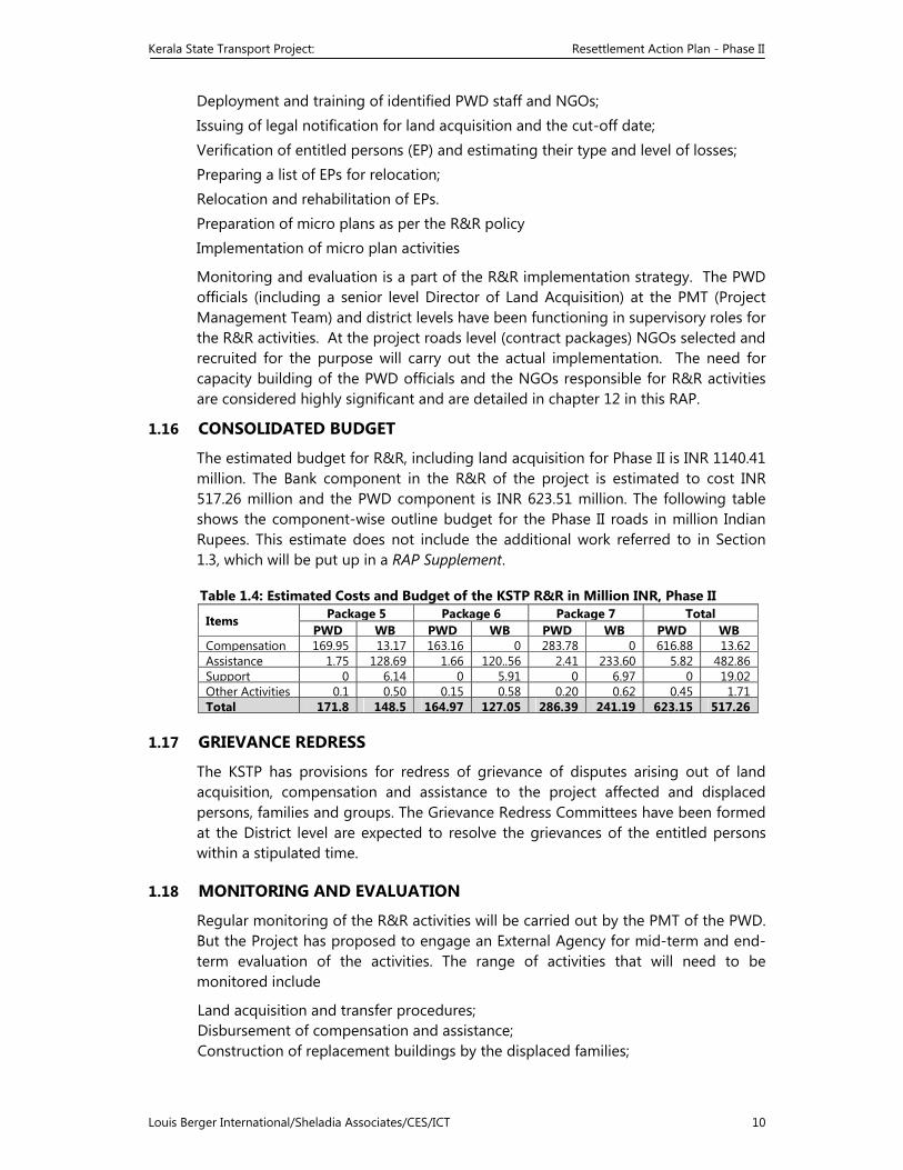
Kerala State Transport Project: Resettlement Action Plan - Phase II
Louis Berger International/Sheladia Associates/CES/ICT 10
Deployment and training of identified PWD staff and NGOs; Issuing of legal notification for land acquisition and the cut-off date; Verification of entitled persons (EP) and estimating their type and level of losses; Preparing a list of EPs for relocation; Relocation and rehabilitation of EPs. Preparation of micro plans as per the R&R policy Implementation of micro plan activities
Monitoring and evaluation is a part of the R&R implementation strategy. The PWD officials (including a senior level Director of Land Acquisition) at the PMT (Project Management Team) and district levels have been functioning in supervisory roles for the R&R activities. At the project roads level (contract packages) NGOs selected and recruited for the purpose will carry out the actual implementation. The need for capacity building of the PWD officials and the NGOs responsible for R&R activities are considered highly significant and are detailed in chapter 12 in this RAP.
1.16 CONSOLIDATED BUDGET
The estimated budget for R&R, including land acquisition for Phase II is INR 1140.41 million. The Bank component in the R&R of the project is estimated to cost INR 517.26 million and the PWD component is INR 623.51 million. The following table shows the component-wise outline budget for the Phase II roads in million Indian Rupees. This estimate does not include the additional work referred to in Section 1.3, which will be put up in a RAP Supplement.
Table 1.4: Estimated Costs and Budget of the KSTP R&R in Million INR, Phase II
Items Package 5 Package 6 Package 7 Total PWD WB PWD WB PWD WB PWD WB
Compensation 169.95 13.17 163.16 0 283.78 0 616.88 13.62Assistance 1.75 128.69 1.66 120..56 2.41 233.60 5.82 482.86Support 0 6.14 0 5.91 0 6.97 0 19.02Other Activities 0.1 0.50 0.15 0.58 0.20 0.62 0.45 1.71Total 171.8 148.5 164.97 127.05 286.39 241.19 623.15 517.26
1.17 GRIEVANCE REDRESS
The KSTP has provisions for redress of grievance of disputes arising out of land acquisition, compensation and assistance to the project affected and displaced persons, families and groups. The Grievance Redress Committees have been formed at the District level are expected to resolve the grievances of the entitled persons within a stipulated time.
1.18 MONITORING AND EVALUATION
Regular monitoring of the R&R activities will be carried out by the PMT of the PWD. But the Project has proposed to engage an External Agency for mid-term and end-term evaluation of the activities. The range of activities that will need to be monitored include
Land acquisition and transfer procedures; Disbursement of compensation and assistance; Construction of replacement buildings by the displaced families;
Kerala State Transport Project: Resettlement Action Plan - Phase II
Louis Berger International/Sheladia Associates/CES/ICT 11
Rehabilitation of displaced families and business enterprises; Rehabilitation of income levels.
Kerala State Transport Project: Resettlement Action Plan - Phase II
Louis Berger International/Sheladia Associates/CES/ICT 12
The monitoring indicators include both input/output indicators and outcome/impact indicators. The input/output indicators relate to the physical progress and the outcome/impact indicators relate to the qualitative progress of the project objectives as stated in the R&R policy. These aspects were discussed in detail in the RAP for the Phase I roads along with sample formats for monitoring. These will be continued through the Phase II roads implementation.
1.19 PUBLIC DISCLOSURE OF THE RAP
Disclosing the details of the project to the public is highly significant to achieve their confidence and cooperation. For information dissemination mass media can be utilised as 90% people of the State are literate and almost everybody reads the newspaper daily. A copy of the RAP for the Phase I roads was kept at the District Information Offices of the project districts, where people have free access. This information will be shared through newspapers advertisements. The same procedure will be followed for the Phase II RAP.
A Malayalam version of the RAP Executive Summary RAP will be kept at affected village offices, in addition to the respective District Information Office.
The RAP will also be available at the World Bank Info shop, Washington DC and New Delhi.
Kerala State Transport Project: Resettlement Action Plan - Phase II
Louis Berger International/Sheladia Associates/CES/ICT 13
2 METHODOLOGY
2.1 INTRODUCTION
This chapter describes the methodology adopted for the collection and analysis of data on social impacts and the plotting of strip maps. It also discusses the method involved for screening and identification of areas of concern and the recommended methodology for the preparation of the RAP. The basic objective of this exercise is to assess the socio-economic and cultural status of the project affected persons.
The action plan is based on primary and secondary data and extensive consultation with the stakeholders. Two sets of questionnaires2 were prepared to collect the primary data: one for collecting information on the resource base of the affected population (a census of population and their assets inventory) and the other to develop the socio-economic database for monitoring and evaluation. These are appended to this Report as Annex 2. The consultations were organised to ensure participation of the stakeholders in the project preparation and to address the needs of different social groups. In summary, a social impact assessment was undertaken, followed by a census and socio-economic surveys of potentially affected persons.
2.2 THE VERIFICATION EXERCISE
The Kerala PWD undertook a joint verification with the State Revenue Department of the road links selected for the Project, to establish the legal boundaries of the right of way (ROW), identify current usage of the land in terms of squatters, land encroachments, fixed and moveable structures, trees and wells, etc.
The information on the revenue survey numbers of the proposed affected families was obtained from the affected persons, if available, and from the respective revenue local level offices. As the revenue litho maps available in the village offices are very big in size, they were conceptually drawn for the project to facilitate the verification exercise.
2.3 SURVEYS
2.3.1 Reconnaissance Level Screening
The purpose of this survey was to assess the possible impact of the project on the people living and/or working along the project roads in terms of loss of shelter and livelihood. The survey also aimed at finding out the potential project affected persons' perception about the project and the initial reaction to the idea of relocation and resettlement. To facilitate the screening process, data were analysed both manually and through a computer model. The computer model generated an overview of the number of persons that would be affected, the extent of land take, and the cost of relocation and rebuilding of structures.
2 Annex 2.1, Schedule for Census Survey of 100% Potential PAPs; and Annex 2.2, Schedule for Baseline Socio-
Economic Survey.
Kerala State Transport Project: Resettlement Action Plan - Phase II
Louis Berger International/Sheladia Associates/CES/ICT 14
The results of the surveys were incorporated into a series of computer models especially developed for the project. For each link the distance to the edge of the corridor, the distance to buildings and the distance between buildings parallel to the road were entered into a spreadsheet and the following were calculated:
Kerala State Transport Project: Resettlement Action Plan - Phase II
Louis Berger International/Sheladia Associates/CES/ICT 15
Width of corridor
• Distance between buildings across the corridor
• The proportion of road (percent) in four width categories: over 20 m, 12-20 m, 10-12 m, and under 10 m
For each of four corridor widths selected by the user (currently set at 9.2, 12, 15 and 30 m representing a 30 foot corridor, a minimum corridor, a 15 m corridor to IRC standards and a dual carriageway respectively) the following were calculated:
Land required to be purchased in order to establish the corridor width
Cost of land required to be purchased
Number of buildings to be demolished
The value of the buildings to be acquired
The number of project affected persons (PAPs)
The number of PAPs per kilometre.
Photographs and informal discussions supplemented the reconnaissance level screening survey with the potentially affected persons to provide an overview of the likely impact. A team of 12 surveyors collected this information, supervised by a senior professional.
2.3.2 Census
The purpose of the household census survey was to gather quantitative information on the loss of land and other productive resources, loss of structures, loss of access to public services, loss of livelihood, loss of access to common property resources, etc. due to the project, for facilitating compensation, resettlement and rehabilitation.
The data for the 100% detailed census survey were collected through the interview method with the help of a structured questionnaire. Based on the preliminary engineering design, property owners and otherwise users likely to be affected by the proposed corridor of impact (COI) were included in the interviews.
Every property (structure and land) coming within the COI was measured from the centreline of the road and along the road. Photographs of affected persons or groups were taken and video documentation of proposed project roads were done. The land parcels were identified by the name of the owners and the Revenue Department survey numbers, if available from the respective Village Offices, which maintain the local land records. The structures were identified by the names and addresses of the owners and/or users, and the people living therein as household members or working there for livelihoods were included in the census. Their social group information was recorded to facilitate privileged dispensation of compensation to the vulnerable groups, as outlined in the R&R policy document. Other demographic features included literacy level, occupation, income of the household members and skills possessed by them, if any. Tenants, encroachers and squatters within the COI were identified based on their statements.
Kerala State Transport Project: Resettlement Action Plan - Phase II
Louis Berger International/Sheladia Associates/CES/ICT 16
The assets inventory included, in addition to structures, agricultural/plantation land, trees (coconuts are the primary cash crop of the State), and private water source. The construction type, viz., pucca (concrete built) and kutcha (mud wall/thatched roof), wall construction material, roofing material and flooring material were also recorded.
The structures were link-wise and left/right side-wise (in progressive chainage direction) serially numbered and within a given structure its multiple units were identified. The structures are further identifiable according to chainage. These numerical orders corresponded with those in the strip mapping exercise that was conducted at the same time.
2.3.3 Socio-Economic Baseline Survey
The purpose of the baseline socio-economic survey was to gather qualitative information on the life style of the PAPs as well as the details of their losses and other adverse impacts such as disruption of social, cultural, religious, or economic activities, due to the project. A sample survey of 25% of the households selected were from the socially and economically poorer sections was also conducted to facilitate monitoring, evaluation and implementation of the RAP.
The information generated through the socio-economic surveys includes- economic activities of the PAPs, household consumption/expenditure patterns, migration patterns, perception about the project, women’s participation in domestic chores, women’s role in household decision making, indebtedness, health status, utility connections at home, etc.
2.3.4 Data Computerisation and Analysis
The interview schedules, completed every day of the surveys, were verified and on completion of data collection in a given link, the data were entered into the computers in the project office using Microsoft Access data programming and processing software.
2.3.5 Data Updating
The lists of affected persons and assets will be updated during the consultancy period as well as during the project implementation phase. Cross verification by the NGOs in the field will be helpful to effect modifications at the time of implementation.
2.4 CONSULTATION METHODS
Public consultations will be helpful to disseminate information about the project to the potentially affected population and to incorporate their views and suggestions in the preparation of the final engineering design and the RAP. Three State level workshops were held at three geographical areas to generate ideas and opinions about the project. The social impact survey team members facilitated extensive consultations at the project road level. The participants of these meetings include members of the local community and the village/panchayath representatives and officials. Public meetings were also held at a number of places on the project links, especially in high level of impacts areas such as narrow corridors where a number of
Kerala State Transport Project: Resettlement Action Plan - Phase II
Louis Berger International/Sheladia Associates/CES/ICT 17
structures or livelihoods are likely to be affected. All these consultations were also helpful to focus attention on public amenities like bus stops, access roads, etc.
Different social and interest groups, such as people engaged in commercial activities, members of the Scheduled Castes and Other Backward Communities, selected on the basis of the socio-economic survey, were invited to focus group discussions. This exercise enabled the Consultants to prepare the RAP vis-a-vis their needs.
2.5 STRIP MAPS AND LAND SCHEDULES
The strip maps represent the land plans as well as the details of the project roads. The strip maps were prepared by walking along the project roads at the same time as the census surveys. The basis of these maps is the preliminary engineering designs. The professional responsible for the strip maps marked every metre of land use on both sides of the road in the maps, which included the details of buildings, bus stops, water sources, water bodies, trees, place names and the administrative unit names. The details of buildings included such information as the use of the building – residential, commercial, governmental, religious, school, health care facility, etc.; number of floors; identification of properties other than buildings, etc.
The maps were subsequently computerised in the project office and the data on land take based on the census, were entered into the maps and the affected areas to be acquired were measured and marked on the maps, to facilitate the setting out of land areas in the field. The ownership of the area between two properties parallel to the road is not clear. It is presumed that this patch of land is Government property.
The strip maps/land plans are accompanied with the land schedules of the respective road links. The schedules contained the computer identification number of each property arranged according to progressive chainage and serial number according to the left and right sides, the use of the property, name of the owner/user, revenue survey number, name of the village and address of the property, the number of affected families (entitled persons) in that property, the total property area and the affected property area, the total building area and the affected building area (if at all), and the vulnerability categories of the affected families. The total property area is inclusive of the building area.
It is necessary to mention that the revenue maps were rarely available with the revenue offices and even when updated versions were not available (For eg in the Link 70, it was last updated in 1920). Moreover, while the PCC design maps are of 1:2000 scales, the maps available with the revenue offices are of disproportionate scales. Therefore, conceptual replica of those maps was prepared.
It should also be noted that the revenue offices have not, in many cases, updated the sub-divided revenue numbers (thandapar number) of a plot. So the Consultants were compelled to record the available information from the revenue offices and the proposed affected persons with regard to the collection of revenue numbers
Kerala State Transport Project: Resettlement Action Plan - Phase II
Louis Berger International/Sheladia Associates/CES/ICT 18
2.6 LIMITATIONS
The limitation in this project has been defined by the fact that the project roadsides are heavily built up with large and permanent structures. Most buildings on the project roads were identified in congested market areas. With the highest population density in the country, social impact data collection along the project roads in the State proved to be a most time consuming exercise.
Moreover, with a twenty-year old history of people migrating or emigrating from the State in search of livelihoods, many affected structures were found locked or otherwise inaccessible and neighbours could not provide any useful information regarding ownership. Locating the owners of the rubber plantations and other agricultural areas along the project roads proved to be a difficult proposition and sometimes an impossible exercise. In such cases, the land schedules marked the property owners as “not known”.
The affected people often gave apparently wrong information on their income and expenditure. In many cases people even refused to talk about their incomes. People were, otherwise, cooperative with the survey process, but the local small businesses, especially the eating places, believed the surveyors to be sales tax agents, sent by the State Revenue Department. In almost all cases the owners of the commercial establishments did not allow the recording of the names and other details of their employees, beyond mentioning their numbers.
When the implementation of the RAP for the Phase I roads was initiated, it is noticed that the number of Eligible Persons recorded is much more. The corridor of impact will be clear only when the stones are laid and then it is easier for the NGOs to identify all eligible persons within the COI.
Similarly, the definition of ”family” in the R&R policy was confusing, as it does not match with the local definitions or usual census definitions. So the total number of PAPs might vary considerably, as all adult members other that the father & mother are to be counted as separate families in a residential plot and all members such as the employer, employee etc as a separate families in a commercial plots, confusing the total number of PAFs. So the NGOs need to closely verify these details for accurate information.. Due to all these close verification of the details in this document by the NGOs is strongly recommended to update these details, when they conduct the verification surveys.
Kerala State Transport Project: Resettlement Action Plan - Phase II
Louis Berger International/Sheladia Associates/CES/ICT 19
3 MINIMISING NEGATIVE SOCIAL IMPACT
3.1 INTRODUCTION
The R&R component of the Project has been prepared according to the R&R Principles and Policy Framework (approved by the Kerala State Government in August 2000), adopted by the Kerala State Transport Project and the World Bank guidelines.3 The Bank policy emphasises the need to avoid or minimise involuntary resettlement on development projects. The KSTP policy, also, acknowledges the importance of avoiding adverse socio-economic impacts in road design and construction. The success of a project depends to a large extent on the improvement that it brings about in the living standards of the people, both in the short and the long term. While preparing the engineering design, the prime consideration has been to minimise the social negative impacts within the limitations of technical requirements and cost effectiveness and to enhance the benefits. Despite the best efforts to minimise the negative social impact, however, land take and resettlement has been unavoidable. The project area on each Link was divided into three broad categories for the assessment of land take, which has implications upon costs and budgeting: Congested market areas with dense placement of structures, including legal title
holders of land plots and structures, and legal4 or illegal squatters; Built up residential areas along the road where there is a requirement for acquisition
of land from existing compound walls and parts of the compound and/or structures;
Roadside agricultural/plantation land.
3.2 OPTIONS CONSIDERED FOR MINIMISING NEGATIVE SOCIAL IMPACTS
3.2.1 Design Considerations
According to the three broad categories mentioned above, a joint decision among the engineering, environmental and social impact teams was taken to avoid land take from religious structures, such as, churches, mosques, temples, graves, sacred groves, etc., congested market areas (which would save both displacement and livelihoods as well as excessive costs), and avoid splitting agricultural fields as far as possible. A set of guidelines with social concern was prepared for the reference of the design engineers and is appended to this Report as Annex 3.1. Realignments have been proposed at a number of places on several of the road links, each length varying from 100 metres to 400 metres. The Environmental
3 OD 4.30/OP 4.12: Involuntary Resettlement. The World Bank, Washington, DC, 1990/1999. 4 Squatting is by definition illegal, but “legal” squatters are those who are authorized by the civic authorities,
such as the municipality or the panchayat, to set up small businesses on small structures, usually raised on a platform, on public lands for a license fee. Locally called bunk, these are usually wooden structures with tin roof.
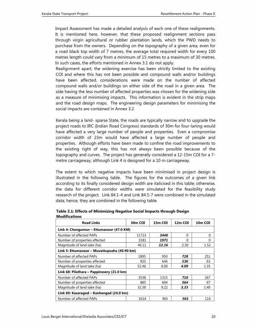
Kerala State Transport Project: Resettlement Action Plan - Phase II
Louis Berger International/Sheladia Associates/CES/ICT 20
Impact Assessment has made a detailed analysis of each one of these realignments. It is mentioned here, however, that these proposed realignment sections pass through virgin agricultural or rubber plantation lands, which the PWD needs to purchase from the owners. Depending on the topography of a given area, even for a road black top width of 7 metres, the average total required width for every 100 metres length could vary from a minimum of 15 metres to a maximum of 30 metres. In such cases, the efforts mentioned in Annex 3.1 do not apply. Realignment apart, the widening exercise has been strictly limited to the existing COI and where this has not been possible and compound walls and/or buildings have been affected, considerations were made on the number of affected compound walls and/or buildings on either side of the road in a given area. The side having the less number of affected properties was chosen for the widening side as a measure of minimising impacts. This information is evident in the strip maps and the road design maps. The engineering design parameters for minimising the social impacts are contained in Annex 3.2. Kerala being a land- sparse State, the roads are typically narrow and to upgrade the project roads to IRC (Indian Road Congress) standards of 30m for four-laning would have affected a very large number of people and properties. Even a compromise corridor width of 23m would have affected a large number of people and properties. Although efforts have been made to confine the road improvements to the existing right of way, this has not always been possible because of the topography and curves. The project has generally considered a 12-15m COI for a 7-metre carriageway, although Link 4 is designed for a 10 m carriageway. The extent to which negative impacts have been minimised in project design is illustrated in the following table. The figures for the outcomes of a given link according to its finally considered design width are italicised in this table; otherwise, the data for different corridor widths were simulated for the feasibility study research of the project. Link 84.1-4 and Link 84.5-7 were combined in the simulated data; hence, they are combined in the following table. Table 3.1: Effects of Minimizing Negative Social Impacts through Design Modifications
Road Links 30m COI 15m COI 12m COI 10m COI
Link 4: Chengannur – Ettumanoor (47.0 KM) Number of affected PAPs 11723 3440 0 0Number of properties affected 3181 1971 0 0 Magnitude of land take (ha) 46.11 12.16 2.30 1.52Link 5: Ettumanoor – Muvattupuzha (40.90 km) Number of affected PAPs 1895 950 728 251 Number of properties affected 925 646 536 63 Magnitude of land take (ha) 52.46 6.00 4.09 1.35Link 68: Pilathara – Pappinssery (21.0 km) Number of affected PAPs 3538 1315 710 267 Number of properties affected 885 604 564 67 Magnitude of land take (ha) 32.38 9.22 3.33 1.40Link 69: Kasaragod – Kanhangad (24.0 km) Number of affected PAPs 1614 965 563 114
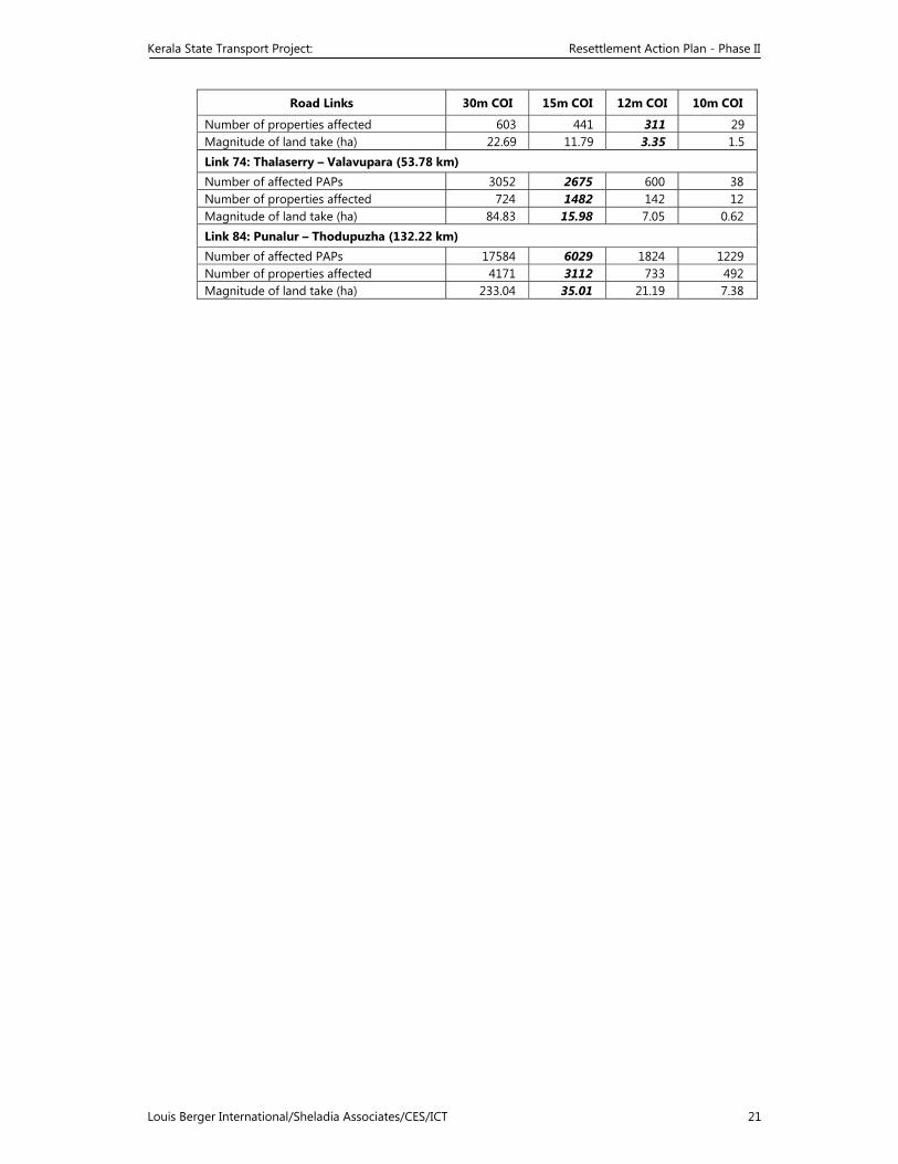
Kerala State Transport Project: Resettlement Action Plan - Phase II
Louis Berger International/Sheladia Associates/CES/ICT 21
Road Links 30m COI 15m COI 12m COI 10m COI
Number of properties affected 603 441 311 29 Magnitude of land take (ha) 22.69 11.79 3.35 1.5 Link 74: Thalaserry – Valavupara (53.78 km) Number of affected PAPs 3052 2675 600 38Number of properties affected 724 1482 142 12 Magnitude of land take (ha) 84.83 15.98 7.05 0.62 Link 84: Punalur – Thodupuzha (132.22 km) Number of affected PAPs 17584 6029 1824 1229 Number of properties affected 4171 3112 733 492 Magnitude of land take (ha) 233.04 35.01 21.19 7.38
Kerala State Transport Project: Resettlement Action Plan - Phase II
Louis Berger International/Sheladia Associates/CES/ICT 22
This table is based on the engineering design. It excludes the Bypass roads, which were not subjected to the original feasibility study but considered to minimise land take and there by reduce the number of affected people, to the extent possible. As the table illustrates, adopting a 30m-road width parameter would have created a major R&R problem, considering the number of affected persons, number of affected structures and the magnitude of land take involved. A COI varying between 12m and 15m has moderately affected the R&R aspects of the project. In this way, the project has made a maximum effort to minimise negative social impacts. As a result of integrating social issues in project preparation, displacement and the need to resettle and/or rehabilitate affected households and persons has been considerably reduced. Additionally, during the verification of the strip maps against the road design maps, whenever it was found that the new road line was just touching by a compound wall or a building, or a compound wall or a building was affected only by half-a-metre to one metre area, the property was marked for saving in the contractor’s maps. Approximately 0.05% properties have been thus additionally saved from being affected.
3.2.2 Public Consultations
Public consultations, discussed in Chapter 7, created another avenue for minimising negative social impacts. The purpose of these consultations was to obtain the views and suggestions of the potentially affected persons on the road design and its potential impacts on the affected people. The affected persons were consulted as “focus groups”, such as a group of affected residents, a group of affected agricultural families, and a group of affected shop owners/traders. These are also interest groups. These interest groups very often came up with alternative suggestions on the alignments. All attempts have been made to accommodate their views and suggestions within the technical feasibility.
3.2.3 Aggrieved People’s Representations
As the census and social impact surveys progressed and the project evolved, more and more potentially affected people and institutions (e.g., religious places, academic institutions, etc.) represented to the project office, requesting to spare their respective properties from land acquisition. Political pressures accompanied certain cases. These requests have been accommodated where ever; it is compatible with the technical feasibility.
3.2.4 Analysis of Alternative and Bypass
The guiding principle with regard to the congested areas has been to limit the road upgrading activities within the available corridor. Design of footpaths over drains and limiting design speed also helped minimise the negative social impact with regard to both land take and road safety. Four bypasses have been proposed for the Phase II roads, (1) Thiruvalla Bypass, (2) Pala Bypass,(3) Adur Bypass and (4) Thodupuzha Bypass. The total length of these four bypasses is approximately 8.2 m, which are actually deviations from the main road..In addition, the Bypass roads save properties/structures on the original route from being severely affected, although it affects agricultural plots.
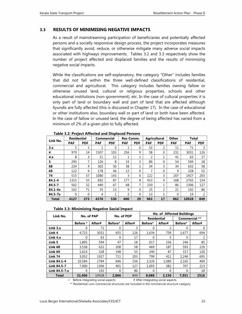
Kerala State Transport Project: Resettlement Action Plan - Phase II
Louis Berger International/Sheladia Associates/CES/ICT 23
3.3 RESULTS OF MINIMISING NEGATIVE IMPACTS
As a result of mainstreaming participation of beneficiaries and potentially affected persons and a socially responsive design process, the project incorporates measures that significantly avoid, reduce, or otherwise mitigate many adverse social impacts associated with highways improvements. Tables 3.2 and 3.3 respectively show the number of project affected and displaced families and the results of minimising negative social impacts.
While the classifications are self-explanatory, the category “Other” includes families that did not fall within the three well-defined classifications of residential, commercial and agricultural. This category includes families owning fallow or otherwise unused land, cultural or religious properties, schools and other educational institutions (non-government), etc. In the case of cultural properties it is only part of land or boundary wall and part of land that are affected although hyundis are fully affected (this is discussed in Chapter 17). In the case of educational or other institutions also, boundary wall or part of land or both have been affected. In the case of fallow or unused land, the degree of being affected has varied from a minimum of 2% of a given plot to fully affected.
Table 3.2: Project Affected and Displaced Persons
Link No. Residential Commercial Res-Comm. Agricultural Other Total PAF PDF PAF PDF PAF PDF PAF PDF PAF PAF PDF
3.x 5 1 1 0 1 0 53 2 11 71 34 979 14 1507 103 256 9 58 0 231 3031 1264.x 8 3 11 12 1 1 2 1 41 63 17 5 295 7 126 8 33 3 86 0 54 594 1868 224 4 302 50 38 1 34 3 34 632 5869 122 9 178 46 12 0 7 0 9 328 55 74 515 57 1080 143 3 0 122 3 207 1927 203 84.1-4 1315 55 692 87 177 8 413 4 168 2765 15484.5-7 562 52 440 67 68 7 150 1 86 1306 127 84.1-4x 10² 71 35 13 9 0 25 2 21 192 86 84.5-7x 0 0 4 1 2 0 13 1 0 19 2
Total 4127 273 4376 530 600 29 963 17 862 10928 849 Table 3.3: Minimizing Negative Social Impact Link No. No. of PAP No. of PDP
No. of Affected Buildings Residential Commercial **
Before * After# Before* After# Before* After# Before* After# Link 3.x 0 71 0 3 0 2 0 0Link 4 4,723 3031 655 126 1,634 759 1,677 694 Link 4.x 0 63 0 17 0 5 0 2Link 5 1,895 594 47 18 617 236 246 85 Link 68 3,538 632 208 58 469 187 593 220Link 69 1,614 328 198 55 240 87 317 120 Link 74 3,052 1927 711 203 799 412 2,246 695 Link 84.1-4 10,584 2784 646 156 3,326 1,080 2,165 469Link 84.5-7 7,000 1306 401 127 1,003 382 707 213 Link 84.5-7.x 0 192 0 86 0 0 0 18
Total 32,406 10928 2,866 849 8,088 3,150 7,951 2516 ∗ Before integrating social aspects # After integrating social aspects ** Residential-cum-commercial structures are included in the commercial structure category
Kerala State Transport Project: Resettlement Action Plan - Phase II
Louis Berger International/Sheladia Associates/CES/ICT 24
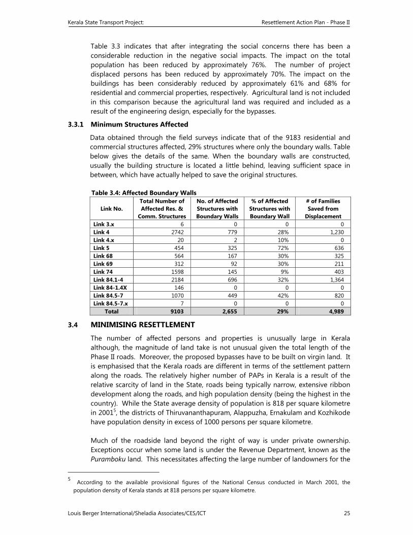
Kerala State Transport Project: Resettlement Action Plan - Phase II
Louis Berger International/Sheladia Associates/CES/ICT 25
Table 3.3 indicates that after integrating the social concerns there has been a considerable reduction in the negative social impacts. The impact on the total population has been reduced by approximately 76%. The number of project displaced persons has been reduced by approximately 70%. The impact on the buildings has been considerably reduced by approximately 61% and 68% for residential and commercial properties, respectively. Agricultural land is not included in this comparison because the agricultural land was required and included as a result of the engineering design, especially for the bypasses.
3.3.1 Minimum Structures Affected
Data obtained through the field surveys indicate that of the 9183 residential and commercial structures affected, 29% structures where only the boundary walls. Table below gives the details of the same. When the boundary walls are constructed, usually the building structure is located a little behind, leaving sufficient space in between, which have actually helped to save the original structures. Table 3.4: Affected Boundary Walls
Link No. Total Number of Affected Res. &
Comm. Structures
No. of Affected Structures with Boundary Walls
% of Affected Structures with Boundary Wall
# of Families Saved from
Displacement Link 3.x 6 0 0 0 Link 4 2742 779 28% 1,230 Link 4.x 20 2 10% 0Link 5 454 325 72% 636 Link 68 564 167 30% 325 Link 69 312 92 30% 211Link 74 1598 145 9% 403Link 84.1-4 2184 696 32% 1,364 Link 84-1.4X 146 0 0 0 Link 84.5-7 1070 449 42% 820Link 84.5-7.x 7 0 0 0
Total 9103 2,655 29% 4,989
3.4 MINIMISING RESETTLEMENT
The number of affected persons and properties is unusually large in Kerala although, the magnitude of land take is not unusual given the total length of the Phase II roads. Moreover, the proposed bypasses have to be built on virgin land. It is emphasised that the Kerala roads are different in terms of the settlement pattern along the roads. The relatively higher number of PAPs in Kerala is a result of the relative scarcity of land in the State, roads being typically narrow, extensive ribbon development along the roads, and high population density (being the highest in the country). While the State average density of population is 818 per square kilometre in 20015, the districts of Thiruvananthapuram, Alappuzha, Ernakulam and Kozhikode have population density in excess of 1000 persons per square kilometre. Much of the roadside land beyond the right of way is under private ownership. Exceptions occur when some land is under the Revenue Department, known as the Puramboku land. This necessitates affecting the large number of landowners for the
5 According to the available provisional figures of the National Census conducted in March 2001, the
population density of Kerala stands at 818 persons per square kilometre.
Kerala State Transport Project: Resettlement Action Plan - Phase II
Louis Berger International/Sheladia Associates/CES/ICT 26
improvement of the roads. Fortunately, the number of project-displaced families is much smaller compared to those, which are affected, approximately 8%. Therefore, the intensity of the resettlement activity in the project is relatively less. Another area of relief is that encroaching and/or squatting on public land is not common on the project roads, although almost all the links have been identified as having a small number of encroacher and squatter families, total 45 and 115, respectively. Otherwise, the non-titleholders are tenants, both residential and commercial. The RAP adequately addresses the issues of rehabilitating the non-titleholders according to the Project’s R&R Principles and Policy. To sum up, several measures have been adopted for minimising the negative social impacts in the Kerala State Transport Project. These include applying socially sensitive design parameters, alternative alignments, introducing bypasses, consultations with the residents, shop owners and aggrieved persons, and limiting land take of private properties, wherever possible, to boundary wall and the compound to avoid or minimise displacement of the families. In light of the evaluation of options discussed in this chapter for minimising negative social impacts, it is emphasised that the magnitude of land take and the number of affected persons and properties have been minimised to the extent possible and the resettlement planned is essential and unavoidable for the improvement of the roads in the State.
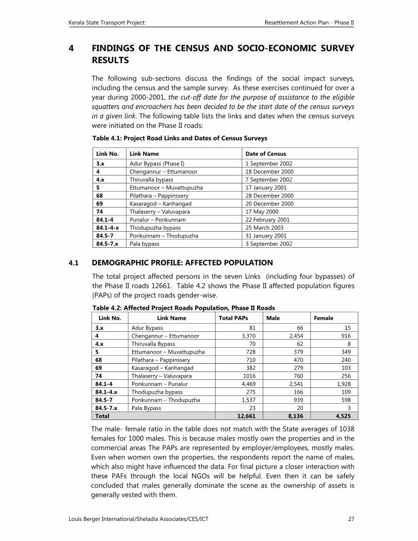
Kerala State Transport Project: Resettlement Action Plan - Phase II
Louis Berger International/Sheladia Associates/CES/ICT 27
4 FINDINGS OF THE CENSUS AND SOCIO-ECONOMIC SURVEY RESULTS
The following sub-sections discuss the findings of the social impact surveys, including the census and the sample survey. As these exercises continued for over a year during 2000-2001, the cut-off date for the purpose of assistance to the eligible squatters and encroachers has been decided to be the start date of the census surveys in a given link. The following table lists the links and dates when the census surveys were initiated on the Phase II roads:
Table 4.1: Project Road Links and Dates of Census Surveys
4.1 DEMOGRAPHIC PROFILE: AFFECTED POPULATION
The total project affected persons in the seven Links (including four bypasses) of the Phase II roads 12661. Table 4.2 shows the Phase II affected population figures (PAPs) of the project roads gender-wise.
Table 4.2: Affected Project Roads Population, Phase II Roads Link No. Link Name Total PAPs Male Female
3.x Adur Bypass 81 66 15 4 Chengannur – Ettumanoor 3,370 2,454 916 4.x Thiruvalla Bypass 70 62 85 Ettumanoor – Muvattupuzha 728 379 349 68 Pilathara – Pappinssery 710 470 240 69 Kasaragod – Kanhangad 382 279 10374 Thalaserry – Valuvapara 1016 760 25684.1-4 Ponkunnam – Punalur 4,469 2,541 1,928 84.1-4.x Thodupuzha bypass 275 166 10984.5-7 Ponkunnam – Thodupuzha 1,537 939 59884.5-7.x Pala Bypass 23 20 3 Total 12,661 8,136 4,525
The male- female ratio in the table does not match with the State averages of 1038 females for 1000 males. This is because males mostly own the properties and in the commercial areas The PAPs are represented by employer/employees, mostly males. Even when women own the properties, the respondents report the name of males, which also might have influenced the data. For final picture a closer interaction with these PAFs through the local NGOs will be helpful. Even then it can be safely concluded that males generally dominate the scene as the ownership of assets is generally vested with them.
Link No. Link Name Date of Census
3.x Adur Bypass (Phase I) 1 September 2002 4 Chengannur – Ettumanoor 18 December 2000 4.x Thiruvalla bypass 7 September 20025 Ettumanoor – Muvattupuzha 17 January 2001 68 Pilathara – Pappinssery 28 December 2000 69 Kasaragod – Kanhangad 20 December 2000 74 Thalaserry – Valuvapara 17 May 200084.1-4 Punalur – Ponkunnam 22 February 2001 84.1-4-x Thodupuzha bypass 25 March 200384.5-7 Ponkunnam – Thodupuzha 31 January 200184.5-7.x Pala bypass 3 September 2002
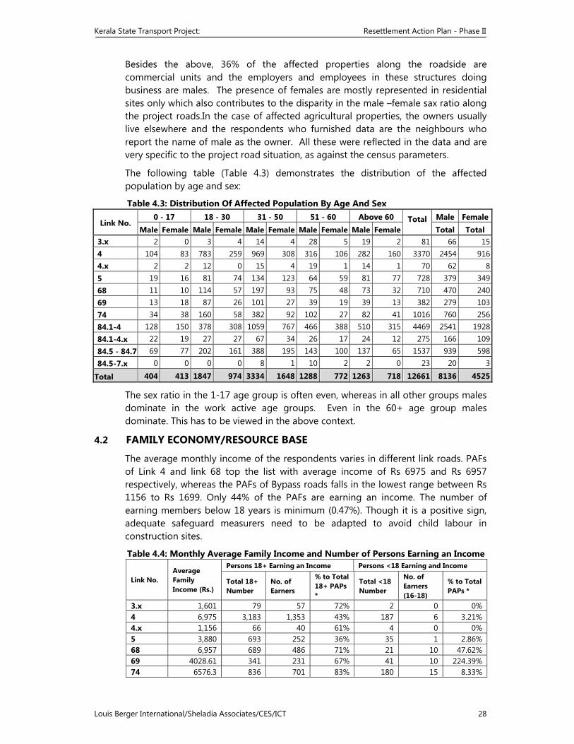
Kerala State Transport Project: Resettlement Action Plan - Phase II
Louis Berger International/Sheladia Associates/CES/ICT 28
Besides the above, 36% of the affected properties along the roadside are commercial units and the employers and employees in these structures doing business are males. The presence of females are mostly represented in residential sites only which also contributes to the disparity in the male –female sax ratio along the project roads.In the case of affected agricultural properties, the owners usually live elsewhere and the respondents who furnished data are the neighbours who report the name of male as the owner. All these were reflected in the data and are very specific to the project road situation, as against the census parameters.
The following table (Table 4.3) demonstrates the distribution of the affected population by age and sex:
Table 4.3: Distribution Of Affected Population By Age And Sex
Link No. 0 - 17 18 - 30 31 - 50 51 - 60 Above 60 Total
Male Female
Male Female Male Female Male Female Male Female Male Female Total Total 3.x 2 0 3 4 14 4 28 5 19 2 81 66 154 104 83 783 259 969 308 316 106 282 160 3370 2454 9164.x 2 2 12 0 15 4 19 1 14 1 70 62 85 19 16 81 74 134 123 64 59 81 77 728 379 34968 11 10 114 57 197 93 75 48 73 32 710 470 24069 13 18 87 26 101 27 39 19 39 13 382 279 10374 34 38 160 58 382 92 102 27 82 41 1016 760 25684.1-4 128 150 378 308 1059 767 466 388 510 315 4469 2541 192884.1-4.x 22 19 27 27 67 34 26 17 24 12 275 166 10984.5 - 84.7 69 77 202 161 388 195 143 100 137 65 1537 939 59884.5-7.x 0 0 0 0 8 1 10 2 2 0 23 20 3
Total 404 413 1847 974 3334 1648 1288 772 1263 718 12661 8136 4525
The sex ratio in the 1-17 age group is often even, whereas in all other groups males dominate in the work active age groups. Even in the 60+ age group males dominate. This has to be viewed in the above context.
4.2 FAMILY ECONOMY/RESOURCE BASE
The average monthly income of the respondents varies in different link roads. PAFs of Link 4 and link 68 top the list with average income of Rs 6975 and Rs 6957 respectively, whereas the PAFs of Bypass roads falls in the lowest range between Rs 1156 to Rs 1699. Only 44% of the PAFs are earning an income. The number of earning members below 18 years is minimum (0.47%). Though it is a positive sign, adequate safeguard measurers need to be adapted to avoid child labour in construction sites.
Table 4.4: Monthly Average Family Income and Number of Persons Earning an Income
Link No. Average Family Income (Rs.)
Persons 18+ Earning an Income Persons <18 Earning and Income
Total 18+ Number
No. of Earners
% to Total 18+ PAPs *
Total <18 Number
No. of Earners (16-18)
% to Total PAPs *
3.x 1,601 79 57 72% 2 0 0% 4 6,975 3,183 1,353 43% 187 6 3.21% 4.x 1,156 66 40 61% 4 0 0%5 3,880 693 252 36% 35 1 2.86% 68 6,957 689 486 71% 21 10 47.62% 69 4028.61 341 231 67% 41 10 224.39%74 6576.3 836 701 83% 180 15 8.33%
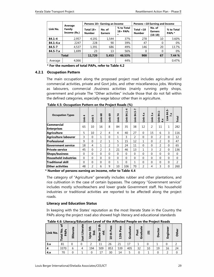
Kerala State Transport Project: Resettlement Action Plan - Phase II
Louis Berger International/Sheladia Associates/CES/ICT 29
Link No. Average Family Income (Rs.)
Persons 18+ Earning an Income Persons <18 Earning and Income
Total 18+ Number
No. of Earners
% to Total 18+ PAPs *
Total <18 Number
No. of Earners (16-18)
% to Total PAPs *
84.1-4 2,957 4,191 1,544 37% 278 10 3.60% 84.1-4.x 2247 228 90 39% 47 0 0%84.5-7 4,537 1,391 686 49% 146 20 13.7%84.5-7.x 1,699 23 13 56% 0 0 0%
Total 11,720 5,453 46.53% 900 67 7.44 %
Average 4,066 44% 0.47%
* For the numbers of total PAPs, refer to Table 4.2
4.2.1 Occupation Pattern
The main occupation along the proposed project road includes agricultural and commercial activities, private and Govt jobs, and other miscellaneous jobs. Working as labourers, commercial /business activities (mainly running petty shops, government and private The “Other activities” include those that do not fall within the defined categories, especially wage labour other than in agriculture.
Table 4.5: Occupation Pattern on the Project Roads (%)
Occupation Types
Link
4
Link
5
Link
68
Link
69
Link
74
Link
84.
1-4
Link
84.
5-7
Link
4.x
Link
3.x
Link
84.
1-4.
x Link
84.
5-7.
x
Tota
l
Commercial Enterprises 65 10 16 8 84 35 38 12 2 11 1 282
Agriculture 5 10 2 4 4 40 27 0 15 6 3 116 Agriculture labourer 3 0 1 0 1 3 2 0 0 2 0 12Professional 9 0 2 1 5 15 12 1 0 2 0 47 Government service 18 4 1 2 3 24 11 0 0 2 0 65Private service 45 0 2 3 21 46 13 1 3 2 0 136 Shops/business 0 0 0 0 0 0 0 0 0 0 0 0Household industries 0 0 0 0 0 0 0 0 0 0 0 0 Traditional skill 0 0 0 0 1 0 1 0 0 0 0 2 Other activities 48 2 6 9 10 106 70 2 4 3 0 260
* Number of persons earning an income, refer to Table 4.4
The category of “Agriculture” generally includes rubber and other plantations, and rice cultivation in the case of certain bypasses. The category “Government service” includes mostly schoolteachers and lower grade Government staff. No household industries or traditional activities are reported to be affectedl along the project roads.
Literacy and Education Status
In keeping with the States’ reputation as the most literate State in the Country the PAPs along the project road also showed high literacy and educational standards
Table 4.6: Literacy/Education Level of the Affected People on the Project Roads
Link No.
Tota
l No.
of
PAPs
Illit
erat
e
Just
Lit
erat
e
Upt
o 5t
h St
d.
Belo
w 1
0 th
st
d.
10 t
h Pa
ss
12th
Pas
s
Gra
duat
e
Post
G
radu
ate
ITI
Doc
tor
Engi
neer
Oth
er
3.x 81 0 0 2 11 26 21 17 1 0 1 0 2 4 3370 6 4 194 509 853 539 405 32 10 19 16 24 4.x 70 0 1 0 17 30 14 5 0 1 0 2 0
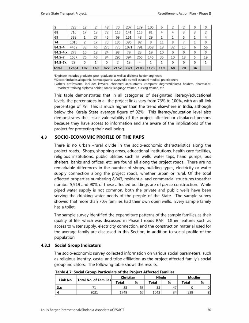
Kerala State Transport Project: Resettlement Action Plan - Phase II
Louis Berger International/Sheladia Associates/CES/ICT 30
5 728 12 2 48 70 207 179 105 6 2 2 0 0 68 710 17 13 72 115 141 115 81 4 4 3 3 2 69 382 1 27 45 69 151 48 29 1 1 5 1 4 74 1016 2 17 73 186 396 92 8 11 8 7 1 084.1-4 4469 33 46 275 775 1071 791 358 18 32 15 6 56 84.1-4.x 275 10 12 24 98 79 23 19 10 0 0 0 0 84.5-7 1537 26 46 84 290 394 265 145 35 10 18 5 19 84.5-7x 23 0 1 0 2 13 4 1 1 0 0 0 1
Total 12661 107 169 822 2152 3371 2103 1173 119 68 70 34
*Engineer includes graduate, post-graduate as well as diploma holder engineers **Doctor includes allopathic, homoeopathic, ayurvedic as well as unani medical practitioners +Others professional includes lawyers, chartered accountants, computer degree/diploma holders, pharmacist,
teachers’ training diploma holder, Arabic language trained, nursing trained, etc.
This table demonstrates that in all categories of designated literacy/educational levels, the percentages in all the project links vary from 73% to 100%, with an all-link percentage of 79. This is much higher than the trend elsewhere in India, although below the Kerala State average figure of 92%. This literacy/education level also demonstrates the lesser vulnerability of the project affected or displaced persons because they have access to information and are aware of the implications of the project for protecting their well being.
4.3 SOCIO-ECONOMIC PROFILE OF THE PAPS
There is no urban –rural divide in the socio-economic characteristics along the project roads. Shops, shopping areas, educational institutions, health care facilities, religious institutions, public utilities such as wells, water taps, hand pumps, bus shelters, banks and offices, etc. are found all along the project roads. There are no remarkable differences in the number of shops, building types, electricity or water supply connection along the project roads, whether urban or rural. Of the total affected properties numbering 8,043, residential and commercial structures together number 5,919 and 90% of these affected buildings are of pucca construction. While piped water supply is not common, both the private and public wells have been serving the drinking water needs of the people of the State. The sample survey showed that more than 70% families had their own open wells. Every sample family has a toilet.
The sample survey identified the expenditure patterns of the sample families as their quality of life, which was discussed in Phase I roads RAP. Other features such as access to water supply, electricity connection, and the construction material used for the average family are discussed in this Section, in addition to social profile of the population.
4.3.1 Social Group Indicators
The socio-economic survey collected information on various social parameters, such as religious identity, caste, and tribe affiliation as the project affected family’s social group indicators. The following table shows the results.
Table 4.7: Social Group Particulars of the Project Affected Families
Link No. Total No. of FamiliesChristian Hindu Muslim
Total % Total % Total % 3.x 71 38 53 33 47 0 04 3031 1749 57 1043 34 239 8
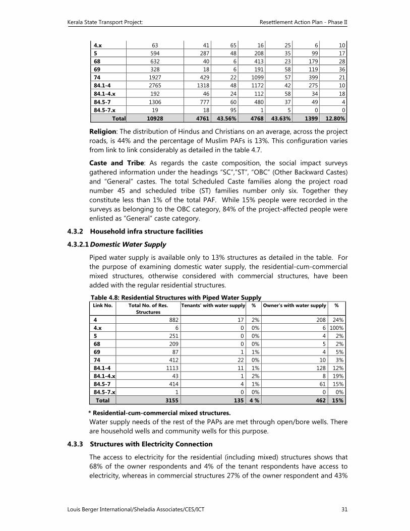
Kerala State Transport Project: Resettlement Action Plan - Phase II
Louis Berger International/Sheladia Associates/CES/ICT 31
4.x 63 41 65 16 25 6 105 594 287 48 208 35 99 1768 632 40 6 413 23 179 2869 328 18 6 191 58 119 3674 1927 429 22 1099 57 399 2184.1-4 2765 1318 48 1172 42 275 1084.1-4.x 192 46 24 112 58 34 1884.5-7 1306 777 60 480 37 49 484.5-7.x 19 18 95 1 5 0 0
Total 10928 4761 43.56% 4768 43.63% 1399 12.80%
Religion: The distribution of Hindus and Christians on an average, across the project roads, is 44% and the percentage of Muslim PAFs is 13%. This configuration varies from link to link considerably as detailed in the table 4.7.
Caste and Tribe: As regards the caste composition, the social impact surveys gathered information under the headings “SC”,”ST”, “OBC” (Other Backward Castes) and “General” castes. The total Scheduled Caste families along the project road number 45 and scheduled tribe (ST) families number only six. Together they constitute less than 1% of the total PAF. While 15% people were recorded in the surveys as belonging to the OBC category, 84% of the project-affected people were enlisted as “General” caste category.
4.3.2 Household infra structure facilities
4.3.2.1 Domestic Water Supply
Piped water supply is available only to 13% structures as detailed in the table. For the purpose of examining domestic water supply, the residential-cum-commercial mixed structures, otherwise considered with commercial structures, have been added with the regular residential structures.
Table 4.8: Residential Structures with Piped Water Supply Link No. Total No. of Res.
Structures Tenants' with water supply % Owner's with water supply %
4 882 17 2% 208 24%4.x 6 0 0% 6 100%5 251 0 0% 4 2%68 209 0 0% 5 2%69 87 1 1% 4 5%74 412 22 0% 10 3%84.1-4 1113 11 1% 128 12%84.1-4.x 43 1 2% 8 19%84.5-7 414 4 1% 61 15%84.5-7.x 1 0 0% 0 0%Total 3155 135 4 % 462 15%
* Residential-cum-commercial mixed structures. Water supply needs of the rest of the PAPs are met through open/bore wells. There are household wells and community wells for this purpose.
4.3.3 Structures with Electricity Connection
The access to electricity for the residential (including mixed) structures shows that 68% of the owner respondents and 4% of the tenant respondents have access to electricity, whereas in commercial structures 27% of the owner respondent and 43%
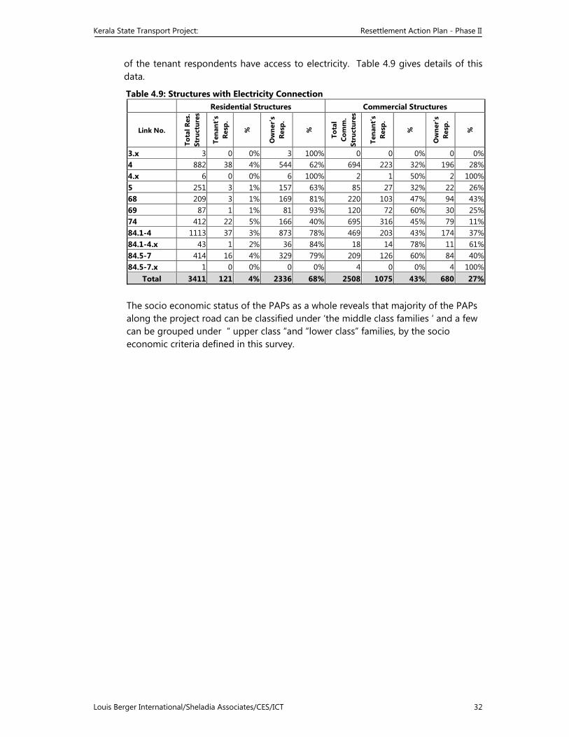
Kerala State Transport Project: Resettlement Action Plan - Phase II
Louis Berger International/Sheladia Associates/CES/ICT 32
of the tenant respondents have access to electricity. Table 4.9 gives details of this data.
Table 4.9: Structures with Electricity Connection Residential Structures Commercial Structures
Link No.
Tota
l Res
. St
ruct
ures
Tena
nt's
Re
sp.
%
Ow
ner'
s Re
sp.
%
Tota
l Co
mm
. St
ruct
ures
Tena
nt's
Re
sp.
%
Ow
ner'
s Re
sp.
%
3.x 3 0 0% 3 100% 0 0 0% 0 0%4 882 38 4% 544 62% 694 223 32% 196 28%4.x 6 0 0% 6 100% 2 1 50% 2 100%5 251 3 1% 157 63% 85 27 32% 22 26%68 209 3 1% 169 81% 220 103 47% 94 43%69 87 1 1% 81 93% 120 72 60% 30 25%74 412 22 5% 166 40% 695 316 45% 79 11%84.1-4 1113 37 3% 873 78% 469 203 43% 174 37%84.1-4.x 43 1 2% 36 84% 18 14 78% 11 61%84.5-7 414 16 4% 329 79% 209 126 60% 84 40%84.5-7.x 1 0 0% 0 0% 4 0 0% 4 100%
Total 3411 121 4% 2336 68% 2508 1075 43% 680 27%
The socio economic status of the PAPs as a whole reveals that majority of the PAPs along the project road can be classified under ‘the middle class families ‘ and a few can be grouped under “ upper class “and “lower class” families, by the socio economic criteria defined in this survey.
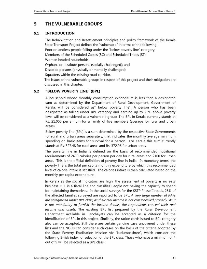
Kerala State Transport Project: Resettlement Action Plan - Phase II
Louis Berger International/Sheladia Associates/CES/ICT 33
5 THE VULNERABLE GROUPS
5.1 INTRODUCTION
The Rehabilitation and Resettlement principles and policy framework of the Kerala State Transport Project defines the “vulnerable” in terms of the following. Poor or landless people falling under the “below poverty line” category; Members of the Scheduled Castes (SC) and Scheduled Tribes (ST); Women headed households; Orphans or destitute persons (socially challenged); and Disabled persons (physically or mentally challenged). Squatters within the existing road corridor. The issues of the vulnerable groups in respect of this project and their mitigation are discussed in this chapter.
5.2 “BELOW POVERTY LINE” (BPL)
A household whose monthly consumption expenditure is less than a designated sum as determined by the Department of Rural Development, Government of Kerala, will be considered as“ below poverty line”. A person who has been designated as falling under BPL category and earning up to 25% above poverty level will be considered as a vulnerable group. The BPL in Kerala currently stands at Rs. 21,000 per annum for a family of five members (average for rural and urban areas). Below poverty line (BPL) is a sum determined by the respective State Governments for rural and urban areas separately, that indicates the monthly average minimum spending on basic items for survival for a person. For Kerala this sum currently stands at Rs. 327.48 for rural areas and Rs. 372.96 for urban areas. The poverty line in India is defined on the basis of recommended nutritional requirements of 2400 calories per person per day for rural areas and 2100 for urban areas. This is the official definition of poverty line in India. In monetary terms, the poverty line is the total per capita monthly expenditure by which this recommended level of calorie intake is satisfied. The calories intake is then calculated based on the monthly per capita expenditure.
In Kerala as the social indicators are high, the assessment of poverty is no easy business. BPL is a fiscal line and classifies People not having the capacity to spend for maintaining themselves. In the social surveys for the KSTP Phase II roads, 28% of the affected families surveyed are reported to be BPL. A very large number of PAFs are categorised under BPL class, as their real income is not crosschecked properly. As it is not mandatory to furnish the income details, the respondents conceal their real income and assets. The existing BPL list prepared by the Rural Development Department available in Panchayats can be accepted as a criterion for the identification of BPL in this project. Similarly, the ration cards issued to BPL category also can be accepted. Still there are certain genuine case uncovered under these lists and the NGOs can consider such cases on the basis of the criteria adopted by the State Poverty Eradication Mission viz “kudumbashree”, which consider the following 9-risk index for selection of the BPL class. Those who have a minimum of 4 out of 9 will be selected as a BPL class.
Kerala State Transport Project: Resettlement Action Plan - Phase II
Louis Berger International/Sheladia Associates/CES/ICT 34
• Families having no land or less than 5 cents of land • No house or dilapidated house • No sanitary latrines • No access to safe drinking water (300m in rural, 150m in urban) • Women headed families/presence of widows/divorcee/abandoned
lady/unwedded mother • No regularly employed in the family • Scheduled caste or scheduled tribe family • Presence of physically or mentally challenged / chronically ill in the family • Family without colour TV set A family with at least 4 of the above 9 indicators was considered a “high risk” or poor family. NGOs can verify to identify the BPL families on the basis of the above for further cross checking of BPL families.
5.3 SCHEDULED CASTES (SC) AND SCHEDULED TRIBES (ST)
All PAPs belonging to the castes classified under Scheduled caste and tribe by the State Government, vide State gazette, can be considered so. They are considered as vulnerable category, as they are the socially and economically deprived sections of the population. In several socio economic indicators such as education, occupational status and income level, these communities lag behind. These deprivations make them vulnerable and special privileges are reserved to ensure them better status in any development/welfare scheme. In KSTP too special consideration is given to SC/ST class. 45 project affected SC families and 6 ST families along the project roads were identified to be eligible for such special privileges.
5.3.1 The Tribal Peoples
The tribal people are variously known as indigenous ethnic minorities. These terms refer to social groups with distinct social and cultural identity and are separate from the dominant society that makes them vulnerable to being disadvantaged in the development process.6
The term “tribal” is often pejorative and has political connotations. The people so described have been traditionally marginalized and exploited all over the world by peoples who have occupied their lands. The Constitution of India provides for a special treatment for the uplift of the tribal peoples in India, known as the Scheduled Tribes (ST).
It was mentioned earlier that the social impact surveys listed only six tribal families as PAF who will be treated according to the R&R Principles and Policy Framework. Though classified as tribals, these six families are very much similar to non-tribals as they are staying in the project roads interacting with others. Surveys established that the’ socio-economic profile, ownership pattern, resource base, participation and institutional arrangement of these families are not different from non-tribals. Moreover, this project does not make any incursion into the virgin tribal areas /settlements which is mostly in interior areas. Hence no attempt has been made to prepare a separate indigenous people’s development plan (IPDP) for KSTP.
6 Operational Directive 4.20: Indigenous Peoples. Washington, DC, The World Bank, 1991.
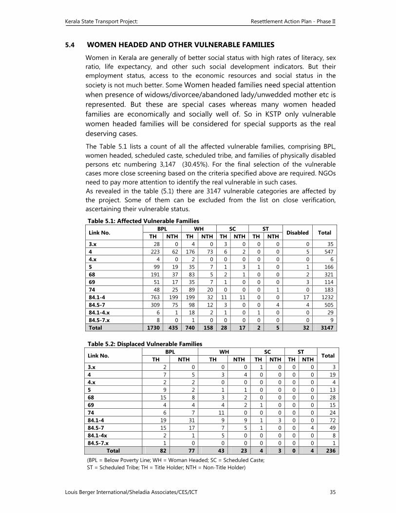
Kerala State Transport Project: Resettlement Action Plan - Phase II
Louis Berger International/Sheladia Associates/CES/ICT 35
5.4 WOMEN HEADED AND OTHER VULNERABLE FAMILIES
Women in Kerala are generally of better social status with high rates of literacy, sex ratio, life expectancy, and other such social development indicators. But their employment status, access to the economic resources and social status in the society is not much better. Some Women headed families need special attention when presence of widows/divorcee/abandoned lady/unwedded mother etc is represented. But these are special cases whereas many women headed families are economically and socially well of. So in KSTP only vulnerable women headed families will be considered for special supports as the real deserving cases.
The Table 5.1 lists a count of all the affected vulnerable families, comprising BPL, women headed, scheduled caste, scheduled tribe, and families of physically disabled persons etc numbering 3,147 (30.45%). For the final selection of the vulnerable cases more close screening based on the criteria specified above are required. NGOs need to pay more attention to identify the real vulnerable in such cases. As revealed in the table (5.1) there are 3147 vulnerable categories are affected by the project. Some of them can be excluded from the list on close verification, ascertaining their vulnerable status.
Table 5.1: Affected Vulnerable Families
Link No. BPL WH SC ST
Disabled Total TH NTH TH NTH TH NTH TH NTH
3.x 28 0 4 0 3 0 0 0 0 35 4 223 62 176 73 6 2 0 0 5 547 4.x 4 0 2 0 0 0 0 0 0 65 99 19 35 7 1 3 1 0 1 166 68 191 37 83 5 2 1 0 0 2 321 69 51 17 35 7 1 0 0 0 3 11474 48 25 89 20 0 0 0 1 0 18384.1-4 763 199 199 32 11 11 0 0 17 1232 84.5-7 309 75 98 12 3 0 0 4 4 50584.1-4.x 6 1 18 2 1 0 1 0 0 2984.5-7.x 8 0 1 0 0 0 0 0 0 9 Total 1730 435 740 158 28 17 2 5 32 3147 Table 5.2: Displaced Vulnerable Families
Link No. BPL WH SC ST
Total TH NTH TH NTH TH NTH TH NTH
3.x 2 0 0 0 1 0 0 0 3 4 7 5 3 4 0 0 0 0 19 4.x 2 2 0 0 0 0 0 0 45 9 2 1 1 0 0 0 0 1368 15 8 3 2 0 0 0 0 28 69 4 4 4 2 1 0 0 0 1574 6 7 11 0 0 0 0 0 2484.1-4 19 31 9 9 1 3 0 0 72 84.5-7 15 17 7 5 1 0 0 4 49 84.1-4x 2 1 5 0 0 0 0 0 884.5-7.x 1 0 0 0 0 0 0 0 1
Total 82 77 43 23 4 3 0 4 236
(BPL = Below Poverty Line; WH = Woman Headed; SC = Scheduled Caste; ST = Scheduled Tribe; TH = Title Holder; NTH = Non-Title Holder)
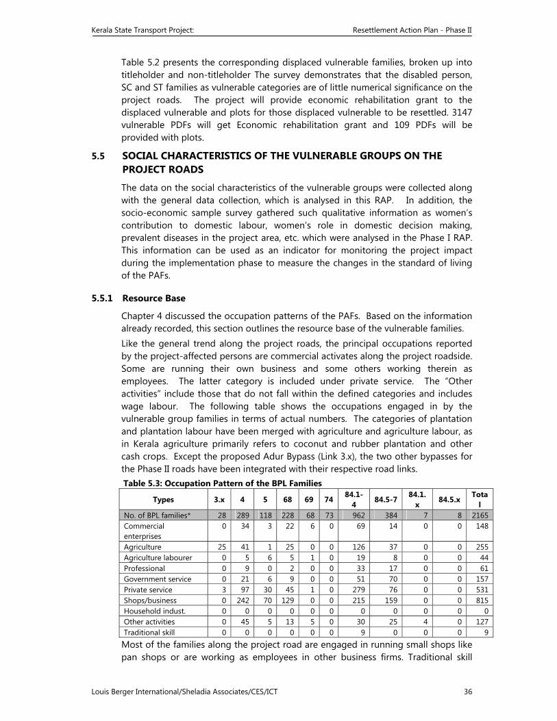
Kerala State Transport Project: Resettlement Action Plan - Phase II
Louis Berger International/Sheladia Associates/CES/ICT 36
Table 5.2 presents the corresponding displaced vulnerable families, broken up into titleholder and non-titleholder The survey demonstrates that the disabled person, SC and ST families as vulnerable categories are of little numerical significance on the project roads. The project will provide economic rehabilitation grant to the displaced vulnerable and plots for those displaced vulnerable to be resettled. 3147 vulnerable PDFs will get Economic rehabilitation grant and 109 PDFs will be provided with plots.
5.5 SOCIAL CHARACTERISTICS OF THE VULNERABLE GROUPS ON THE PROJECT ROADS
The data on the social characteristics of the vulnerable groups were collected along with the general data collection, which is analysed in this RAP. In addition, the socio-economic sample survey gathered such qualitative information as women’s contribution to domestic labour, women’s role in domestic decision making, prevalent diseases in the project area, etc. which were analysed in the Phase I RAP. This information can be used as an indicator for monitoring the project impact during the implementation phase to measure the changes in the standard of living of the PAFs.
5.5.1 Resource Base
Chapter 4 discussed the occupation patterns of the PAFs. Based on the information already recorded, this section outlines the resource base of the vulnerable families. Like the general trend along the project roads, the principal occupations reported by the project-affected persons are commercial activates along the project roadside. Some are running their own business and some others working therein as employees. The latter category is included under private service. The “Other activities” include those that do not fall within the defined categories and includes wage labour. The following table shows the occupations engaged in by the vulnerable group families in terms of actual numbers. The categories of plantation and plantation labour have been merged with agriculture and agriculture labour, as in Kerala agriculture primarily refers to coconut and rubber plantation and other cash crops. Except the proposed Adur Bypass (Link 3.x), the two other bypasses for the Phase II roads have been integrated with their respective road links. Table 5.3: Occupation Pattern of the BPL Families
Types 3.x 4 5 68 69 74 84.1-4
84.5-7 84.1.x
84.5.x Total
No. of BPL families* 28 289 118 228 68 73 962 384 7 8 2165 Commercial enterprises
0 34 3 22 6 0 69 14 0 0 148
Agriculture 25 41 1 25 0 0 126 37 0 0 255Agriculture labourer 0 5 6 5 1 0 19 8 0 0 44 Professional 0 9 0 2 0 0 33 17 0 0 61 Government service 0 21 6 9 0 0 51 70 0 0 157Private service 3 97 30 45 1 0 279 76 0 0 531 Shops/business 0 242 70 129 0 0 215 159 0 0 815 Household indust. 0 0 0 0 0 0 0 0 0 0 0Other activities 0 45 5 13 5 0 30 25 4 0 127Traditional skill 0 0 0 0 0 0 9 0 0 0 9
Most of the families along the project road are engaged in running small shops like pan shops or are working as employees in other business firms. Traditional skill
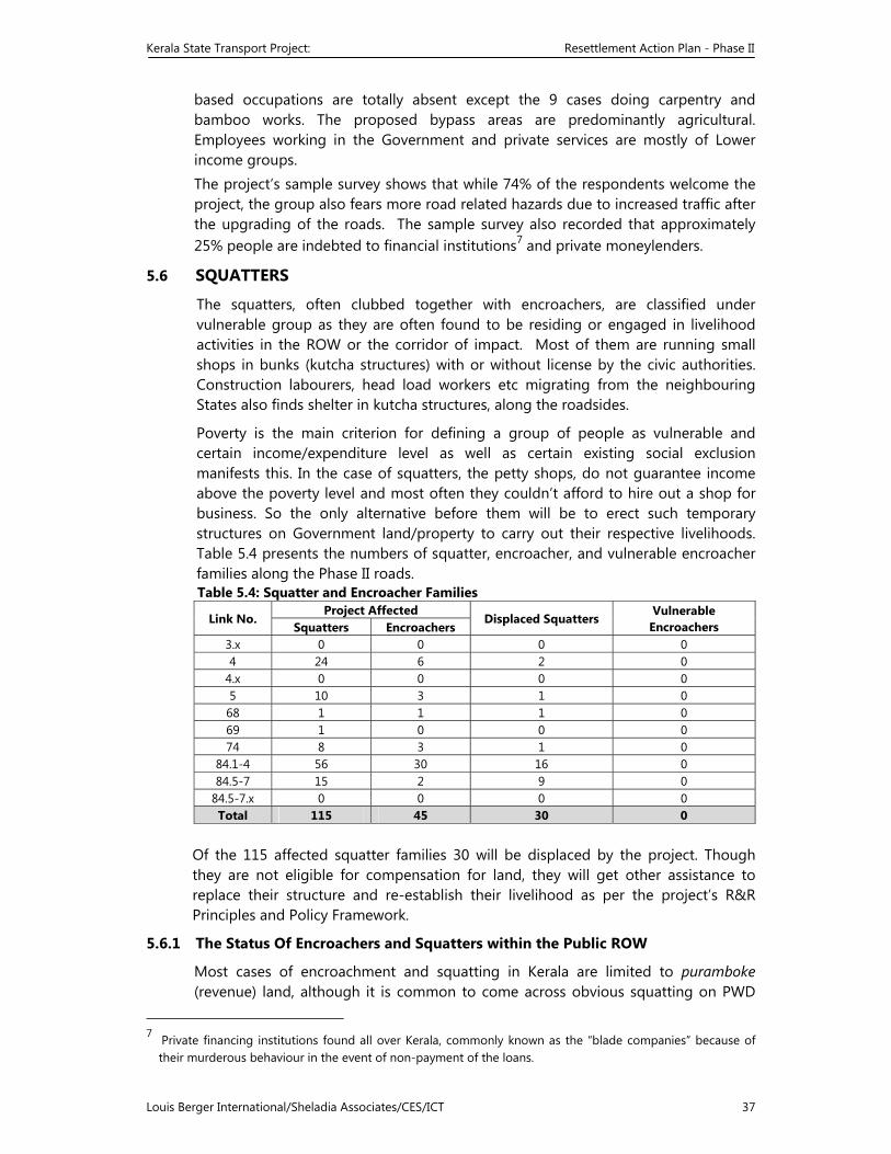
Kerala State Transport Project: Resettlement Action Plan - Phase II
Louis Berger International/Sheladia Associates/CES/ICT 37
based occupations are totally absent except the 9 cases doing carpentry and bamboo works. The proposed bypass areas are predominantly agricultural. Employees working in the Government and private services are mostly of Lower income groups. The project’s sample survey shows that while 74% of the respondents welcome the project, the group also fears more road related hazards due to increased traffic after the upgrading of the roads. The sample survey also recorded that approximately 25% people are indebted to financial institutions7 and private moneylenders.
5.6 SQUATTERS
The squatters, often clubbed together with encroachers, are classified under vulnerable group as they are often found to be residing or engaged in livelihood activities in the ROW or the corridor of impact. Most of them are running small shops in bunks (kutcha structures) with or without license by the civic authorities. Construction labourers, head load workers etc migrating from the neighbouring States also finds shelter in kutcha structures, along the roadsides.
Poverty is the main criterion for defining a group of people as vulnerable and certain income/expenditure level as well as certain existing social exclusion manifests this. In the case of squatters, the petty shops, do not guarantee income above the poverty level and most often they couldn’t afford to hire out a shop for business. So the only alternative before them will be to erect such temporary structures on Government land/property to carry out their respective livelihoods. Table 5.4 presents the numbers of squatter, encroacher, and vulnerable encroacher families along the Phase II roads. Table 5.4: Squatter and Encroacher Families
Link No. Project Affected
Displaced Squatters Vulnerable
Encroachers Squatters Encroachers 3.x 0 0 0 0 4 24 6 2 0
4.x 0 0 0 0 5 10 3 1 0 68 1 1 1 0 69 1 0 0 0 74 8 3 1 0
84.1-4 56 30 16 0 84.5-7 15 2 9 0
84.5-7.x 0 0 0 0 Total 115 45 30 0
Of the 115 affected squatter families 30 will be displaced by the project. Though they are not eligible for compensation for land, they will get other assistance to replace their structure and re-establish their livelihood as per the project’s R&R Principles and Policy Framework.
5.6.1 The Status Of Encroachers and Squatters within the Public ROW
Most cases of encroachment and squatting in Kerala are limited to puramboke (revenue) land, although it is common to come across obvious squatting on PWD
7 Private financing institutions found all over Kerala, commonly known as the “blade companies” because of
their murderous behaviour in the event of non-payment of the loans.
Kerala State Transport Project: Resettlement Action Plan - Phase II
Louis Berger International/Sheladia Associates/CES/ICT 38
land, such as a roadside vendor on the ROW. The surveys showed that most of the squatters are small shop owners who are licensed to carry out their livelihood activities on the municipality or panchayat or puramboke land. Some are without license.
The surveys identified only those bunks as squatters whose owners did not have a license from the civic authorities (Municipality or Panchayath, as the case may be). Those who have licence were recorded as commercial enterprises and even though the individuals did not own the land on which the bunks were raised. Other squatters included labourers residing on the roadside.
Kerala State Transport Project: Resettlement Action Plan - Phase II
Louis Berger International/Sheladia Associates/CES/ICT 39
6 RESETTLEMENT POLICIES AND LEGAL FRAMEWORK
6.1 INTRODUCTION
The Public Works Department of Kerala has prepared the R&R Principles and Policy Framework for the Kerala State Transport Project in accordance with the principles laid down in the World Bank OD 4.30 on Involuntary Resettlement, OD 4.20 on Indigenous Peoples and the legal framework of the Government of India. The Kerala State Government approved this policy document in August 2000. This action plan has been prepared on the basis of the broad outlines formulated in the policy document (Annex 6.1).
6.2 POLICIES AND LEGAL FRAMEWORK
6.2.1 The World Bank Policy
The World Bank has set out certain mandatory social impact mitigation requirements for its loan projects. The OD 4.30 describes the Bank policy and procedures for projects that involve involuntary resettlement. This policy aims to improve, or at a minimum, restore the welfare of the people who will be displaced because of a development project. This policy also requires that projects minimize the need for involuntary resettlement. Where displacement is unavoidable, resettlement plans should pay particular attention to the vulnerable groups. The other relevant Bank document, OD 4.20 provides specific safeguards when indigenous peoples are anticipated to be adversely affected by a development project.
6.2.2 The Indian Legal Framework
The most relevant Indian regulations for facilitating resettlement and rehabilitation are: The Land Acquisition Act, 1894 (amended 1984). This Act is the principal document for procedures to be followed for acquisition of land by the Government for public purposes and for determining compensation. While this Act does not per se provide for mitigation measures, its Section 23 discusses compensation at market price, the market value of land being determined "at the date of the publication of the notification." The Environmental Guidelines for Rail/Road/Highway Projects, Ministry of Environment & Forest, Government of India, 1989, on relocation of project affected persons. These are just guidelines and the Government is not bound to implement these provisions. Nevertheless, the Guidelines have a section on relocation, which recommends the following mitigation measures for social impacts: (a) Advance notification of enough (say, two years) time must be given to enable
the relocatees to find a suitable place. At the same time, the project authorities could arrange for public relations through television, radio, and advertisement on the need for the project and how land acquisition and compensation will be effected.
(b) Advance realistic payment should be available in some form for the relocatees to secure a new unit.
Kerala State Transport Project: Resettlement Action Plan - Phase II
Louis Berger International/Sheladia Associates/CES/ICT 40
(c) The estimation of compensation for land and property should be based on the fair market value. The term fair market value is defined as being the amount at which the property would exchange between a willing buyer and a willing seller and both parties should have reasonable knowledge of all relevant facts.
(d) The choice of replacement of a living unit organized by the project authority may be made available for the relocatees who are not satisfied with the compensation amount or who cannot find a suitable house.
(e) Re-establishment cost must be carefully considered to offset the loss in income, increase in expenditure resulting from disconnection of public utility services and moving cost. Special attention must be paid to the possible loss of job or business that cannot be re-established.
(f) In case of any squatters, a special programme for construction of a low cost housing unit (the labour provided by relocatees) may be set up.
(g) A social work subsection should be established to follow up and monitor the problems faced by the relocatees. This sub-section should also be entrusted with the responsibility to ensure that individual households relocated receive sufficient compensation with enough lead-time to secure a living unit.
The Environmental Impact Assessment Notification, 1994, on comprehensive rehabilitation plan. This Notification, which applies to highway projects costing more than Rs. 50 crore (Rs. 500 million), has a provision for a comprehensive rehabilitation plan, if more than 1000 persons are likely to be displaced. It requires the impact assessment agency (i.e., the PWD) to prepare a set of recommendations based on technical assessment of documents and data, in interaction with the affected people and environmental groups.
6.3 ASSESSMENT OF CURRENT LAND ACQUISITION PRACTICES, THEIR APPROPRIATENESS AND POTENTIAL IMPACTS FOR THIS PROJECT
6.3.1 The Land Acquisition Act, 1891
The LA Act, legislated in British India and amended as late as 1984, guides the basis of the Indian land acquisition practices. The salient features of the LA Act, relevant for this project, are listed below:
"Whenever it appears to the appropriate Government that land in any locality is needed or is likely to be needed for any public purpose,a notification to that effect shall be published in the Official Gazette and in two daily newspapers circulating in that locality, of which at least one shall be in the regional language and the Collector shall cause public notice of the substance of such notification to be given at convenient places in the said locality." (The LA Act, 4.1)
The LA Act explains the expression public purpose and the nearest explanation for this project approximates "the provision of land for town or rural planning." (The LA Act, 3.f.ii)
It would be lawful for a government representative to enter upon and survey a person’s property only after issuing the notification mentioned above. (The LA Act, 4.2)
Kerala State Transport Project: Resettlement Action Plan - Phase II
Louis Berger International/Sheladia Associates/CES/ICT 41
Any person receiving a notice under section 4.1 has a right to file his objection, if any, to the acquisition of his land within 30 days of the issue of the notification. (The LA Act, 5A.1)
Such objections are to be made to the Collector in writing. The Collector will give the objector an opportunity to be heard and, based on that and after further inquiry will write his recommendations on the objections. However, the decision of the appropriate Government on the objections will be final. (The LA Act, 5A.2)
The Collector is empowered to fix the amount of compensation, by agreement, if possible. (The LA Act, 11)
The land acquisition process has to be completed within two years from the last of the publication dates. If it is not so done, the entire proceedings for the acquisition of the land will lapse. (The LA Act, 11A)8
However, in cases of urgency, the Collector is empowered to take possession of a notified land after 15 days of the expiry of the last notification, even if no award has been made. (The LA Act, 17)
Any affected person not satisfied with the award of the Collector has a right to make a reference to a Court within six weeks from the date of the Collector’s award with regard to (1) the measurement of the land, (2) the amount of the compensation, (3) the persons to whom it is payable, and (4) the apportionment of the award among the persons affected. (The LA Act, 18)
In determining the amount of compensation, the Court will consider compensation at “market value”, the market value of the land being determined “at the date of the publication of the notification.” (The LA Act, 23)
In addition to the market value of the land, the Court will also award in every such case a solatium of 30% on such market value, in consideration of the compulsory nature of the acquisition. (The LA Act, 23.2)
The amount of compensation awarded by the Court will not be lower than the amount awarded by the Collector. (The LA Act, 25)
No award or agreement made under the Land Acquisition Act 1894/1984 will be chargeable with stamp duty, and no person claiming under any such award or agreement would be liable to pay any fee for a copy of the same. (The LA Act, 51)
Discussion
For any land acquisition by the Government, the Land Acquisition Act under section 4(1) stipulates publication of a notification to that effect in the official Gazette and in two daily newspapers circulated in the locality, of which at least shall be in the regional (“vernacular”) language. After the notification, the Land Acquisition Officer (LAO) will make a preliminary survey to ascertain the suitability of the land in question and determine the exact portion of the land to be required. The conclusions arrived at are announced in the form of a public notice at a convenient place in the locality in which the land is to be acquired. Such a notification provides
8 In computing the period of two years referred to in this section, the period during which any action is stayed
by an order of a Court is to be excluded.
Kerala State Transport Project: Resettlement Action Plan - Phase II
Louis Berger International/Sheladia Associates/CES/ICT 42
an opportunity to the affected parties to file objections to the proposed acquisition under section 5A of the LA Act.
It is to be emphasised, however, that written notices in public places are not sufficient. This project proposes special emphasis on the information dissemination process through personal contact and the audio-visual media. It will be the duty of the R&R Committees in each district to fully ensure that each affected PAP is fully aware of the procedures and their possibilities and rights to participate in the process.
As the Government acquires private land for “public purposes” which are defined in the Act, a court of law is not empowered to entertain any litigation regarding the appropriateness of the “public purpose”. The law is also silent if any person, other than the “interested person” can object to the Government order under section 4(1) for acquisition of private land.
Kerala State Transport Project: Resettlement Action Plan - Phase II
Louis Berger International/Sheladia Associates/CES/ICT 43
In order to proceed with the acquisition of the notified land or any portion of it, a declaration under section 6 of the Act specifying the precise boundaries of the area of the land need to be made. Every declaration is to be published in the official gazette and in two daily newspapers, which have circulation in the local areas. With the appearance of the notification under section 6 of the Act in the Gazette, the Revenue Department issues a direction to the Collector under section 7 of the Act to issue the order for acquisition of the notified land and/or other immovable properties. Section 8 of the Act requires land to be marked out, measured and planned, while under section 9 notices are served to the concerned person stating the intention of the Government to take possession of the land and that any claims for compensation should be made to the Collector. Finally, the award of compensation is made by the Collector under section 11 of the Act after enquiring into objections (if any) in pursuant to the notice given under section 9, to the measurements made under section 8 and into the value of the land on the date of publication of the notification under section 4(1). The award under section 11 is made within two years from the date of publication of the declaration and if no award is made within this period the entire proceedings of the land acquisition lapses and a fresh notification needs to be initiated. Once the award is made, the Collector takes possession of the land, which thereupon vests absolutely in the Government free from all encumbrances. This process is exhibited in the accompanying flow chart.
Land is in the Eminent Domain under the Indian laws and in case of an emergency, section 17 of the Act empowers the Collector to take possession of the land after 15 days of issuing notice under section 4(1). However, section 17 of the LA Act is invoked only when it is considered to be absolutely necessary.
The above discussion makes it clear that the Indian LA Act has built in safeguard measures to protect the interests of the common man titleholder of land under normal circumstances. If an “interested person” is not satisfied with the award or with the measurement of his land to be acquired by the Government, he is free to approach a court of law for redress of his grievances. Experience and precedents show, however, that this is a lengthy exercise and takes a long time to resolve. Moreover, social impact assessment is a part of the greater environmental concern and the formal land acquisition process cannot commence until the Ministry of Environment and Forest of the Government of India, has approved the Environmental Impact Assessment. This is an integrated programme which itself takes a long time to effect, and the whole process inordinately delays the current land acquisition practice.
6.4 ENTITLEMENTS FOR LOSS OF LAND TENURE
The R&R policy framework of the KSTP provides for the compensation of agricultural land at replacement value. The land tenure consists of only ownership. Land is under the State subject in the Constitution of India and the land laws of Kerala abolished the system of land tenure based on sharecropping or tenancy in the 1960s. The social impact surveys identified persons who worked as labourers on agricultural land, eligible for receiving assistance for the loss of their wage income.
Kerala State Transport Project: Resettlement Action Plan - Phase II
Louis Berger International/Sheladia Associates/CES/ICT 44
6.4.1 The Resettlement Policy
The Kerala State Transport Project’s Resettlement & Rehabilitation Principles and Policy Framework provides guidance for a developmental approach to resettle and rehabilitate the people affected by the project. In particular the policy document highlights that: Wherever possible, displacement will be reduced or avoided altogether by sensitive
design of civil works (viz., alternative designs or modifications to the design). Where displacement is unavoidable, those displaced will have their living standards
improved. As far as possible, the displaced persons from one location will be located as a
single unit. Particular attention will be paid to the needs of the most vulnerable groups to be resettled.
The PAPs will be compensated at replacement cost for assets lost, irrespective of their legal standing in the project area. Special assistance will be extended to the vulnerable to enhance their earning opportunities.
The PAPs and the host communities will be encouraged to participate in the design and the implementation of the RAP.
6.4.2 Definitions
The policy document, to be found as Annex 6.1, describes all of the relevant definitions of the terms used. Some of the important definitions are highlighted here:
The cut-off date for titleholders will be the date of issue of the notice under section 4(1) of The Land Acquisition Act (1894/1984). In the case of non-title holders it is the date of the start of the census survey in the respective road links.
A person above the age of 18 years has been defined as a separate family unit and will be eligible for support, if affected by the project.
A project affected person (PAP) is one who sustains damage as a consequence of the project by (a) reasons of severing such land or (b) affecting his/her immovable properties in any manner or (c) adversely affecting his/her livelihood/earnings calculated by an objective assessment. This category includes project displaced persons.
A project displaced person (PDP) is one who is compelled to change his/her place of residence and/or work place or place of business due to the project.
The category of vulnerable group of persons is defined as those persons falling under the "Below Poverty Line" category and earning up to 25% above the poverty level. This group includes the disadvantaged persons belonging to the Scheduled Castes and Tribes, disabled persons, orphans, destitute persons and women headed households.
Below poverty line (BPL) is a sum determined by the respective State Governments for rural and urban areas separately, that indicates the monthly average minimum spending on basic items for survival for a person. For Kerala this sum currently stands at Rs. 327.48 for rural areas and Rs. 372.96 for urban areas.
Kerala State Transport Project: Resettlement Action Plan - Phase II
Louis Berger International/Sheladia Associates/CES/ICT 45
The poverty line in India is defined on the basis of recommended nutritional requirements of 2400 calories per person per day for rural areas and 2100 for urban areas. This is the official definition of poverty line in India. In monetary terms, the poverty line is the total per capita monthly expenditure by which this recommended level of calorie intake is satisfied. The calories intake is then calculated based on the monthly per capita expenditure.
An encroacher is a person who has trespassed on Government land, adjacent to his/her own land or asset to which he/she is not entitled and who derives his/her livelihood and housing from the encroached land prior to the cut-off date.
A squatter is a person who has settled on Government owned land (and other private land) for housing or livelihood without permission or who has been occupying publicly owned building without authority prior to the cut-off date.
6.5 ENTITLEMENT POLICIES FOR EACH CATEGORY OF IMPACT
The R&R policy of the project provides for a comprehensive package of compensation and assistance to entitled persons, families and groups suffering losses as a result of the project. It provides mitigating measures for:
Loss of assets, including land , house or work place; Loss of livelihood or income opportunities; and Collective impacts on groups, such as loss of community assets, common property
resources and others. Even in cases where no compensation for land is possible, as in the case of encroachers and squatters who are illegal occupants of land, the project will offer compensation and assistance for physical structures, relocation and rehabilitation.
The implementation of the administration of compensation will be based on specific provisions as agreed in the RAP.
6.5.1 Method of Valuation of Losses
The method of valuation of compensation used for affected structures, land, trees, other assets and assistance has been detailed in Chapter 16. The compensation values vary according to the use pattern and place, but an average amount has been used for indicative purposes.
6.5.2 Measures to avoid Litigation
Precedents show that land transfer almost always involves litigation, which is costly and time consuming. Under the Land Acquisition Act 1894/1984, an affected person may accept the award of compensation under protest and appeal to a court of law for further reference. To avoid litigation, the R&R policy of the project has a provision for setting up State and district level committees to assess the replacement value of a property and advise the R&R Cell of the PWD accordingly. The most important expected outcome of these committees is the deliberation of the difference of valuation between the amount of award of compensation by the District Collector and the replacement value of the property. The agreeable
Kerala State Transport Project: Resettlement Action Plan - Phase II
Louis Berger International/Sheladia Associates/CES/ICT 46
difference will be offered to the affected persons under the head of replacement value.
6.6 SUMMARY OF ENTITLEMENT MATRIX
The broad entitlement framework comprising the compensation and assistance is summarized in Table 6.1.
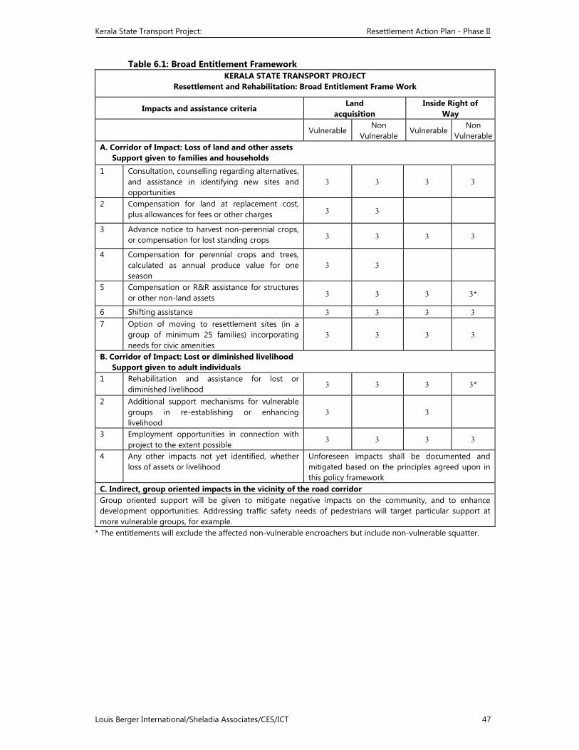
Kerala State Transport Project: Resettlement Action Plan - Phase II
Louis Berger International/Sheladia Associates/CES/ICT 47
Table 6.1: Broad Entitlement Framework KERALA STATE TRANSPORT PROJECT
Resettlement and Rehabilitation: Broad Entitlement Frame Work
Impacts and assistance criteria Land
acquisition Inside Right of
Way
Vulnerable Non
Vulnerable Vulnerable
NonVulnerable
A. Corridor of Impact: Loss of land and other assets Support given to families and households
1 Consultation, counselling regarding alternatives, and assistance in identifying new sites and opportunities
3 3 3 3
2 Compensation for land at replacement cost, plus allowances for fees or other charges 3 3
3 Advance notice to harvest non-perennial crops, or compensation for lost standing crops 3 3 3 3
4 Compensation for perennial crops and trees, calculated as annual produce value for one season
3 3
5 Compensation or R&R assistance for structures or other non-land assets 3 3 3 3*
6 Shifting assistance 3 3 3 3 7 Option of moving to resettlement sites (in a
group of minimum 25 families) incorporating needs for civic amenities
3 3 3 3
B. Corridor of Impact: Lost or diminished livelihoodSupport given to adult individuals
1 Rehabilitation and assistance for lost or diminished livelihood 3 3 3 3*
2 Additional support mechanisms for vulnerable groups in re-establishing or enhancing livelihood
3 3
3 Employment opportunities in connection with project to the extent possible
3 3 3 3
4 Any other impacts not yet identified, whether loss of assets or livelihood
Unforeseen impacts shall be documented and mitigated based on the principles agreed upon in this policy framework
C. Indirect, group oriented impacts in the vicinity of the road corridor Group oriented support will be given to mitigate negative impacts on the community, and to enhance development opportunities. Addressing traffic safety needs of pedestrians will target particular support at more vulnerable groups, for example.
* The entitlements will exclude the affected non-vulnerable encroachers but include non-vulnerable squatter.
Kerala State Transport Project: Resettlement Action Plan - Phase II
Louis Berger International/Sheladia Associates/CES/ICT 48
7 CONSULTATION AND PARTICIPATION
7.1 INTRODUCTION
Development projects are by definition external interventions in which the intended target groups or their representatives have no direct involvement in the process of project preparation and negotiation. But for sustainable development, participation and involvement of the beneficiaries is considered inevitable in modern thinking. Development institutions are using various methods participatory methods that come under the name of "participatory development" or "people's participation", which is considered as a prerequisite for sustainable development.
In this project context, participatory consultation and involvement of people are considered crucial. Experience indicates that involuntary resettlement generally leads to a number of problems for the affected population. But when people are properly informed and consulted about the project, allowing them to make meaningful choices through informed decision-making, problems are much less and atleast they themselves are competent to solve the problems with lesser efforts. People also feel secure and confident.
Therefore, as indicated in Chapter 2, the project preparation involved consultations with stakeholders, proposed project affected persons and groups in the forms of scoping workshops, project level individual and focus group meetings, district and State level meetings.
7.2 LEVELS OF CONSULTATION
The public consultation exercise during the project preparation involved information dissemination - informing the people about the details of the project and to invite their comments before finalizing the engineering design. The consultations were carried out with individuals during the screening survey stage and with both individuals and groups during the detailed social impact surveys. In addition, three State level scoping workshops were conducted in three different key locations during January-February, 2000.
Detailed project information brochures were prepared and distributed to nearly 200 NGOs, Government Agencies, university and research institute experts and other interested parties, and they were invited to take part in or provide information to the scoping workshops organised by the PCC. These consultations were intended to substantially enrich project planning and design, improve public awareness of development objectives of the Government of Kerala and promote project acceptability and transparency.
The consultations and their methodology were reported in the RAP for the Phase I roads and the follow up consultations were reported separately. In this Phase II RAP consultations organised along the Phase II roads are included as Annex 7. These public consultations were helpful to save cultural sights, common property resources and private utilities, through realignment s.
But more intensified information disclosure at Panchayat level are required through the NGOs for establishing a more responsive feedback and grievance Redressal mechanism including effective monitoring and reporting system.
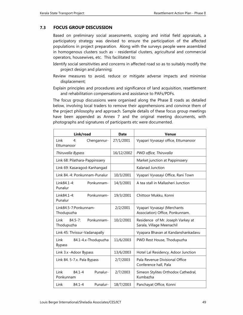
Kerala State Transport Project: Resettlement Action Plan - Phase II
Louis Berger International/Sheladia Associates/CES/ICT 49
7.3 FOCUS GROUP DISCUSSION
Based on preliminary social assessments, scoping and initial field appraisals, a participatory strategy was devised to ensure the participation of the affected populations in project preparation. Along with the surveys people were assembled in homogenous clusters such as - residential clusters, agricultural and commercial operators, housewives, etc. This facilitated to: Identify social sensitivities and concerns in affected road so as to suitably modify the
project design and planning; Review measures to avoid, reduce or mitigate adverse impacts and minimise
displacement; Explain principles and procedures and significance of land acquisition, resettlement
and rehabilitation compensations and assistance to PAFs/PDFs. The focus group discussions were organised along the Phase II roads as detailed below, involving local traders to remove their apprehensions and convince them of the project philosophy and approach. Sample details of these focus group meetings have been appended as Annex 7 and the original meeting documents, with photographs and signatures of participants etc were documented.
Link/road Date Venue
Link 4: Chengannur-Ettumanoor
27/1/2001 Vyapari Vyvasayi office, Ettumanoor
Thiruvalla Bypass 16/12/2002 PWD office, Thiruvalla
Link 68: Pilathara-Pappinssery Market junction at Pappinssery
Link 69: Kasaragod-Kanhangad Kalanad Junction
Link 84.-4: Ponkunnam-Punalur 10/3/2001 Vyapari Vyvasayi Office, Rani Town
Link84.1-4: Ponkunnam-Punalur
14/3/2001 A tea stall in Mallasheri Junction
Link84.1-4: Ponkunnam-Punalur
19/3/2001 Chittoor Mukku, Konni
Link84.5-7:Ponkunnam-Thodupuzha
2/2/2001 Vyapari Vyvasayi (Merchants Association) Office, Ponkunnam.
Link 84.5-7: Ponkunnam-Thodupuzha
10/2/2001 Residence of Mr. Joseph Varkey at Sarala, Village Meenachil
Link 45: Thrissur-Vadanapally Vyapara Bhavan at Kandanshankadavu
Link 84.1-4.x-Thodupuzha Bypass
11/6/2003 PWD Rest House, Thodupuzha
Link 3.x -Adoor Bypass 13/6/2003 Hotel Lal Residency, Adoor Junction
Link 84. 5-7.x. Pala Bypass 2/7/2003 Pala Revenue Divisional Office Conference hall, Pala
Link 84.1-4 Punalur-Ponkunnam
2/7/2003 Simeon Stylites Orthodox Cathedral, Kumbazha
Link 84.1-4 Punalur- 18/7/2003 Panchayat Office, Konni
Kerala State Transport Project: Resettlement Action Plan - Phase II
Louis Berger International/Sheladia Associates/CES/ICT 50
Ponkunnam
Link 84.1-4 Punalur-Ponkunnam
18/7/2003 Panchayat office, Pramadam, Pathanamthitta
Three more consultations were organised in along, at the Kanjani Vyapari Vyvasayi Ekopana Samithi at Kanjani, also along Link 45: Thrissur-Vadanapally, and at the Vyapari Vyvasayi Office at Karthikapuram along Link 67: Thaliparamba-Manakadavu. These consultations have not been included, as these road links were deleted from the priority road links of the KSTP.
The views and suggestions of the stakeholders raised in such meetings were incorporated into the engineering design, wherever feasible, so as to reduce the negative impacts likely to be caused by the project The following table presents the broad issues and concerns raised in the consultations and action taken in this connection.
Table 7.1: Design Response to Stakeholder/Community Concerns
# Stakeholder or Community
Concerns/Suggestions Project Design Outcome/Action Taken
I. Individual Concerns/Suggestions 1 Road congested; require footpath/ cycle path and
parking area . Footpaths and street lighting have been provided in the design for school and congested areas and parking areas provided in market areas.
2 Drainage and water logging problems The project design has provision for covered drains in town areas and line drain in other areas.
3 Protection of paddy fields; provision of slopes The design has taken care of this. 4 Road safety problems: road signing, speed
reducing bumps, curve straightening and sight distance needed
Road signing and lining have been proposed. Realignments and bypasses have taken care of the curve problems to a large extent.
5 Provide bus bays and waiting sheds Bus lay bys have been planned as per land availability. 6 Build a circle at the Nedumbassery International
Airport junction. Has been considered in the design.
7 Provide signal post at every junction. Not recommended but a system of priorities has been designed for each major junction.
8 Provide permanent arrangements for lying of cables, pipelines, etc. by the side of the road to prevent periodic cutting of the roadsides.
Has been incorporated in designs for urban areas.
9 Avoid height difference between soil area and tarring area at both sides of the road.
Agreed good highways practice and has been incorporated in designs.
10 Use reflectors to show the demarcation line. Cat’s eyes are not general practice but have been recommended.
11 BTR number and Field Survey Maps should be consulted and compared before field investigation for identifying encroachment.
Suggestion well taken.
II. Focus Group Concerns/Suggestions 1 Focus group discussion with a group of affected
traders at Ettumanoor on Link 4. Queries included:
The extent to which their properties would be affected and the level of compensation.
Will it be possible to harvest the products before acquisition?
A bypass for Ettumanoor and Kottayam towns via Thavalakuzhy Junction, Poovathimudu and Thiruvanchoor.
After the acquisition of private land, when an owner rebuilds his house, would there be a
Explained in detail.
Yes, sufficient time allotted for harvesting.
Under consideration,.
In the case of small land holdings, building rules provide
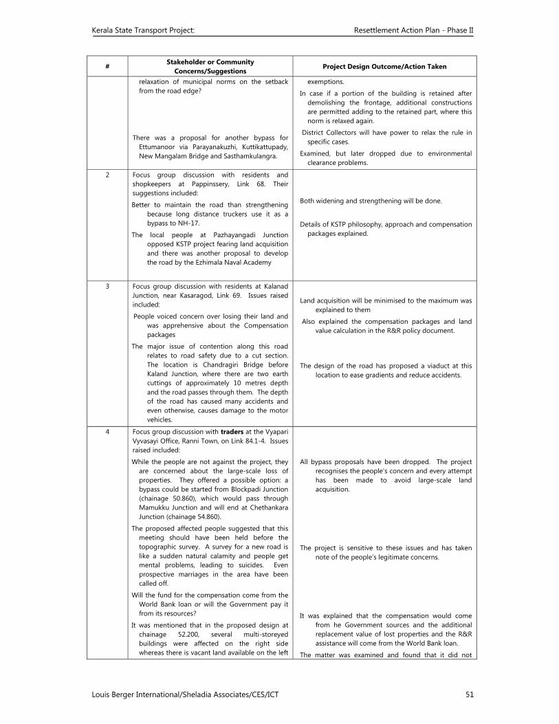
Kerala State Transport Project: Resettlement Action Plan - Phase II
Louis Berger International/Sheladia Associates/CES/ICT 51
# Stakeholder or Community
Concerns/Suggestions Project Design Outcome/Action Taken
relaxation of municipal norms on the setback from the road edge?
There was a proposal for another bypass for Ettumanoor via Parayanakuzhi, Kuttikattupady, New Mangalam Bridge and Sasthamkulangra.
exemptions.
In case if a portion of the building is retained after demolishing the frontage, additional constructions are permitted adding to the retained part, where this norm is relaxed again.
District Collectors will have power to relax the rule in specific cases.
Examined, but later dropped due to environmental clearance problems.
2 Focus group discussion with residents and shopkeepers at Pappinssery, Link 68. Their suggestions included:
Better to maintain the road than strengthening because long distance truckers use it as a bypass to NH-17.
The local people at Pazhayangadi Junction opposed KSTP project fearing land acquisition and there was another proposal to develop the road by the Ezhimala Naval Academy
Both widening and strengthening will be done.
Details of KSTP philosophy, approach and compensation packages explained.
3 Focus group discussion with residents at Kalanad Junction, near Kasaragod, Link 69. Issues raised included:
People voiced concern over losing their land and was apprehensive about the Compensation packages
The major issue of contention along this road relates to road safety due to a cut section. The location is Chandragiri Bridge before Kaland Junction, where there are two earth cuttings of approximately 10 metres depth and the road passes through them. The depth of the road has caused many accidents and even otherwise, causes damage to the motor vehicles.
Land acquisition will be minimised to the maximum was explained to them
Also explained the compensation packages and land value calculation in the R&R policy document.
The design of the road has proposed a viaduct at this location to ease gradients and reduce accidents.
4 Focus group discussion with traders at the Vyapari Vyvasayi Office, Ranni Town, on Link 84.1-4. Issues raised included:
While the people are not against the project, they are concerned about the large-scale loss of properties. They offered a possible option: a bypass could be started from Blockpadi Junction (chainage 50.860), which would pass through Mamukku Junction and will end at Chethankara Junction (chainage 54.860).
The proposed affected people suggested that this meeting should have been held before the topographic survey. A survey for a new road is like a sudden natural calamity and people get mental problems, leading to suicides. Even prospective marriages in the area have been called off.
Will the fund for the compensation come from the World Bank loan or will the Government pay it from its resources?
It was mentioned that in the proposed design at chainage 52.200, several multi-storeyed buildings were affected on the right side whereas there is vacant land available on the left
All bypass proposals have been dropped. The project recognises the people’s concern and every attempt has been made to avoid large-scale land acquisition.
The project is sensitive to these issues and has taken note of the people’s legitimate concerns.
It was explained that the compensation would come from he Government sources and the additional replacement value of lost properties and the R&R assistance will come from the World Bank loan.
The matter was examined and found that it did not
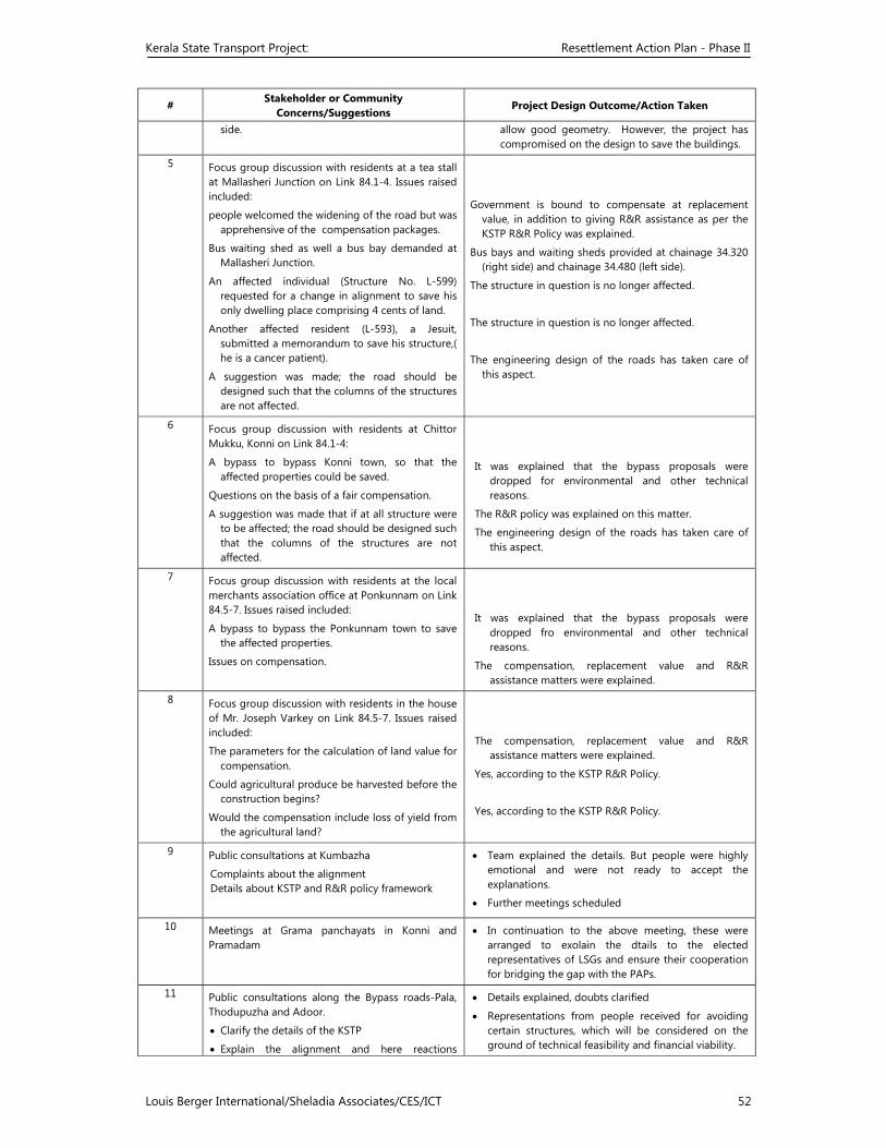
Kerala State Transport Project: Resettlement Action Plan - Phase II
Louis Berger International/Sheladia Associates/CES/ICT 52
# Stakeholder or Community
Concerns/Suggestions Project Design Outcome/Action Taken
side. allow good geometry. However, the project has compromised on the design to save the buildings.
5 Focus group discussion with residents at a tea stall at Mallasheri Junction on Link 84.1-4. Issues raised included:
people welcomed the widening of the road but was apprehensive of the compensation packages.
Bus waiting shed as well a bus bay demanded at Mallasheri Junction.
An affected individual (Structure No. L-599) requested for a change in alignment to save his only dwelling place comprising 4 cents of land.
Another affected resident (L-593), a Jesuit, submitted a memorandum to save his structure,( he is a cancer patient).
A suggestion was made; the road should be designed such that the columns of the structures are not affected.
Government is bound to compensate at replacement value, in addition to giving R&R assistance as per the KSTP R&R Policy was explained.
Bus bays and waiting sheds provided at chainage 34.320 (right side) and chainage 34.480 (left side).
The structure in question is no longer affected.
The structure in question is no longer affected.
The engineering design of the roads has taken care of this aspect.
6 Focus group discussion with residents at Chittor Mukku, Konni on Link 84.1-4:
A bypass to bypass Konni town, so that the affected properties could be saved.
Questions on the basis of a fair compensation.
A suggestion was made that if at all structure were to be affected; the road should be designed such that the columns of the structures are not affected.
It was explained that the bypass proposals were dropped for environmental and other technical reasons.
The R&R policy was explained on this matter.
The engineering design of the roads has taken care of this aspect.
7 Focus group discussion with residents at the local merchants association office at Ponkunnam on Link 84.5-7. Issues raised included:
A bypass to bypass the Ponkunnam town to save the affected properties.
Issues on compensation.
It was explained that the bypass proposals were dropped fro environmental and other technical reasons.
The compensation, replacement value and R&R assistance matters were explained.
8 Focus group discussion with residents in the house of Mr. Joseph Varkey on Link 84.5-7. Issues raised included:
The parameters for the calculation of land value for compensation.
Could agricultural produce be harvested before the construction begins?
Would the compensation include loss of yield from the agricultural land?
The compensation, replacement value and R&R assistance matters were explained.
Yes, according to the KSTP R&R Policy.
Yes, according to the KSTP R&R Policy.
9 Public consultations at Kumbazha
Complaints about the alignment Details about KSTP and R&R policy framework
• Team explained the details. But people were highly emotional and were not ready to accept the explanations.
• Further meetings scheduled
10 Meetings at Grama panchayats in Konni and Pramadam
• In continuation to the above meeting, these were arranged to exolain the dtails to the elected representatives of LSGs and ensure their cooperation for bridging the gap with the PAPs.
11 Public consultations along the Bypass roads-Pala, Thodupuzha and Adoor.
• Clarify the details of the KSTP
• Explain the alignment and here reactions
• Details explained, doubts clarified
• Representations from people received for avoiding certain structures, which will be considered on the ground of technical feasibility and financial viability.
Kerala State Transport Project: Resettlement Action Plan - Phase II
Louis Berger International/Sheladia Associates/CES/ICT 53
# Stakeholder or Community
Concerns/Suggestions Project Design Outcome/Action Taken
/suggestions
Suggested Future Consultations
Public consultations are effective. People like to here the details from the authorities directly. Patient hearing and sympathetic consideration to the genuine grievances will yield positive results.
NGOs engaged for RAP implementation can carry this forward through close interactions with the people.
The District R&R Team needs to closely monitor the field reactions and initiate timely actions to solve issues as and when it arises.
Elected representatives can play positive role in bridging the gaps with the aggrieved PAPs, once they are convinced of the details. Road development is an area of their keen interest and involvement.
Coordinator in the R&R Cell of the PMT will be responsible for monitoring this suggested consultations to be carried out throughout the project period are outlined below:
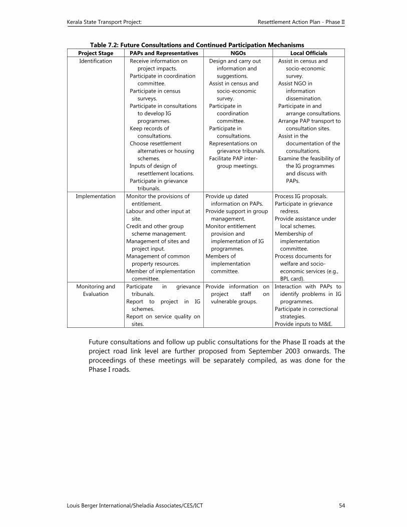
Kerala State Transport Project: Resettlement Action Plan - Phase II
Louis Berger International/Sheladia Associates/CES/ICT 54
Table 7.2: Future Consultations and Continued Participation Mechanisms Project Stage PAPs and Representatives NGOs Local Officials Identification Receive information on
project impacts. Participate in coordination
committee. Participate in census
surveys. Participate in consultations
to develop IG programmes.
Keep records of consultations.
Choose resettlement alternatives or housing schemes.
Inputs of design of resettlement locations.
Participate in grievance tribunals.
Design and carry out information and suggestions.
Assist in census and socio-economic survey.
Participate in coordination committee.
Participate in consultations.
Representations on grievance tribunals.
Facilitate PAP inter-group meetings.
Assist in census and socio-economic survey.
Assist NGO in information dissemination.
Participate in and arrange consultations.
Arrange PAP transport to consultation sites.
Assist in the documentation of the consultations.
Examine the feasibility of the IG programmes and discuss with PAPs.
Implementation Monitor the provisions of entitlement.
Labour and other input at site.
Credit and other group scheme management.
Management of sites and project input.
Management of common property resources.
Member of implementation committee.
Provide up dated information on PAPs.
Provide support in group management.
Monitor entitlement provision and implementation of IG programmes.
Members of implementation committee.
Process IG proposals. Participate in grievance
redress. Provide assistance under
local schemes. Membership of
implementation committee.
Process documents for welfare and socio-economic services (e.g., BPL card).
Monitoring and Evaluation
Participate in grievance tribunals.
Report to project in IG schemes.
Report on service quality on sites.
Provide information on project staff on vulnerable groups.
Interaction with PAPs to identify problems in IG programmes.
Participate in correctional strategies.
Provide inputs to M&E.
Future consultations and follow up public consultations for the Phase II roads at the project road link level are further proposed from September 2003 onwards. The proceedings of these meetings will be separately compiled, as was done for the Phase I roads.
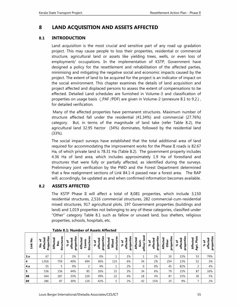
Kerala State Transport Project: Resettlement Action Plan - Phase II
Louis Berger International/Sheladia Associates/CES/ICT 55
8 LAND ACQUISITION AND ASSETS AFFECTED
8.1 INTRODUCTION
Land acquisition is the most crucial and sensitive part of any road up gradation project. This may cause people to loss their properties, residential or commercial structure, agricultural land or assets like yielding trees, wells, or even loss of employment/ occupations. In the implementation of KSTP, Government have designed a policy for the resettlement and rehabilitation of the affected parties, minimising and mitigating the negative social and economic impacts caused by the project. The extent of land to be acquired for the project is an indicator of impact on the social environment. This chapter examines the details of land acquisition and project affected and displaced persons to assess the extent of compensations to be effected. Detailed Land schedules are furnished in Volume-3 and classification of properties on usage basis (_PAF /PDF) are given in Volume-2 (annexure 8.1 to 9.2.) , for detailed verification.
Many of the affected properties have permanent structures. Maximum number of structure affected fall under the residential (41.34%) and commercial (27.76%) category. But, in terms of the magnitude of land take (refer Table 8.2), the agricultural land 32.95 hector (34%) dominates, followed by the residential land (33%).
The social impact surveys have established that the total additional area of land required for accommodating the improvement works for the Phase II roads is 82.67 Ha, of which private land is 78.31 Ha (Table 8.2). The government property includes 4.36 Ha of land area, which includes approximately 1.9 Ha of forestland and structures that were fully or partially affected, as identified during the surveys. Preliminary joint verification by the PWD and the Forest Department determined that a few realignment sections of Link 84.1-4 passed near a forest area. The RAP will, accordingly, be updated as and when confirmed information becomes available.
8.2 ASSETS AFFECTED
The KSTP Phase II will affect a total of 8,081 properties, which include 3,150 residential structures, 2,516 commercial structures, 282 commercial-cum-residential mixed structures, 917 agricultural plots, 197 Government properties (buildings and land) and 1,019 properties not belonging to any of these categories, classified under “Other” category Table 8.1 such as fallow or unused land, bus shelters, religious properties, schools, hospitals, etc. Table 8.1: Number of Assets Affected
Link
No.
No.
of
Aff
ecte
d Pr
oper
ties
Aff
ecte
d Re
s.
Stru
ctur
es
% o
f af
fect
ed
prop
erti
es
Aff
ecte
d Co
mm
. St
ruct
ures
% o
f af
fect
ed
prop
erti
es
Aff
ecte
d M
ixed
st
ruct
ures
% o
f af
fect
ed
prop
erti
es
Aff
ecte
d G
ovt.
of
fice
/ la
nd
% o
f af
fect
ed
prop
erti
es
Aff
ecte
d O
ther
pr
oper
ties
% o
f af
fect
ed
prop
erti
es
Aff
ecte
d A
gri.
Plot
s
% o
f af
fect
ed
prop
erti
es
3.x 67 2 3% 0 0% 1 1% 1 1% 10 15% 53 79%
4 1,916 759 40% 694 36% 123 6% 34 2% 254 13% 52 3%
4.x 55 5 9% 2 4% 1 2% 0 0% 45 82% 2 4%
5 536 236 44% 85 16% 15 3% 34 6% 79 15% 87 16%
68 564 187 33% 220 39% 22 4% 18 3% 87 15% 30 5%
69 286 87 30% 120 42% 5 2% 42 15% 25 9% 7 2%
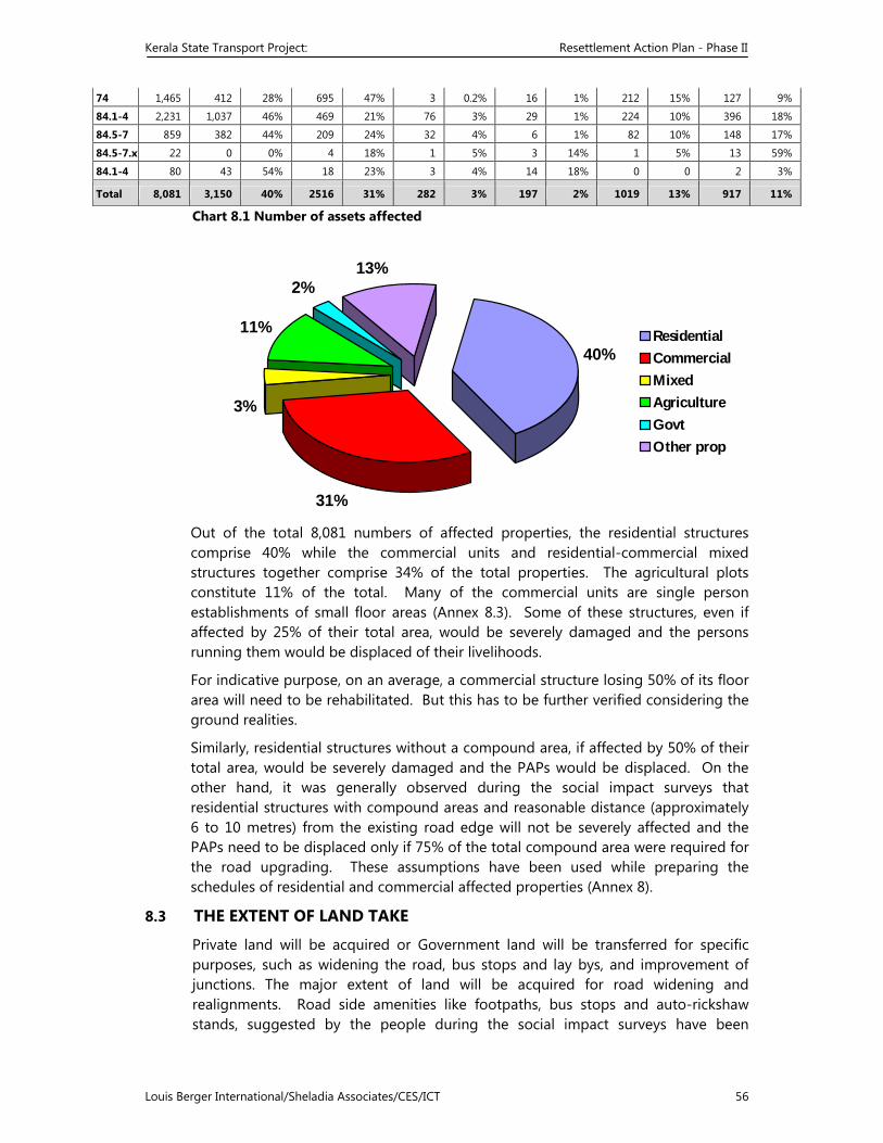
Kerala State Transport Project: Resettlement Action Plan - Phase II
Louis Berger International/Sheladia Associates/CES/ICT 56
74 1,465 412 28% 695 47% 3 0.2% 16 1% 212 15% 127 9%
84.1-4 2,231 1,037 46% 469 21% 76 3% 29 1% 224 10% 396 18%
84.5-7 859 382 44% 209 24% 32 4% 6 1% 82 10% 148 17%
84.5-7.x 22 0 0% 4 18% 1 5% 3 14% 1 5% 13 59%
84.1-4 80 43 54% 18 23% 3 4% 14 18% 0 0 2 3%
Total 8,081 3,150 40% 2516 31% 282 3% 197 2% 1019 13% 917 11%
Chart 8.1 Number of assets affected
40%
31%
3%
11%
2%13%
ResidentialCommercialMixedAgricultureGovtOther prop
Out of the total 8,081 numbers of affected properties, the residential structures comprise 40% while the commercial units and residential-commercial mixed structures together comprise 34% of the total properties. The agricultural plots constitute 11% of the total. Many of the commercial units are single person establishments of small floor areas (Annex 8.3). Some of these structures, even if affected by 25% of their total area, would be severely damaged and the persons running them would be displaced of their livelihoods.
For indicative purpose, on an average, a commercial structure losing 50% of its floor area will need to be rehabilitated. But this has to be further verified considering the ground realities.
Similarly, residential structures without a compound area, if affected by 50% of their total area, would be severely damaged and the PAPs would be displaced. On the other hand, it was generally observed during the social impact surveys that residential structures with compound areas and reasonable distance (approximately 6 to 10 metres) from the existing road edge will not be severely affected and the PAPs need to be displaced only if 75% of the total compound area were required for the road upgrading. These assumptions have been used while preparing the schedules of residential and commercial affected properties (Annex 8).
8.3 THE EXTENT OF LAND TAKE
Private land will be acquired or Government land will be transferred for specific purposes, such as widening the road, bus stops and lay bys, and improvement of junctions. The major extent of land will be acquired for road widening and realignments. Road side amenities like footpaths, bus stops and auto-rickshaw stands, suggested by the people during the social impact surveys have been
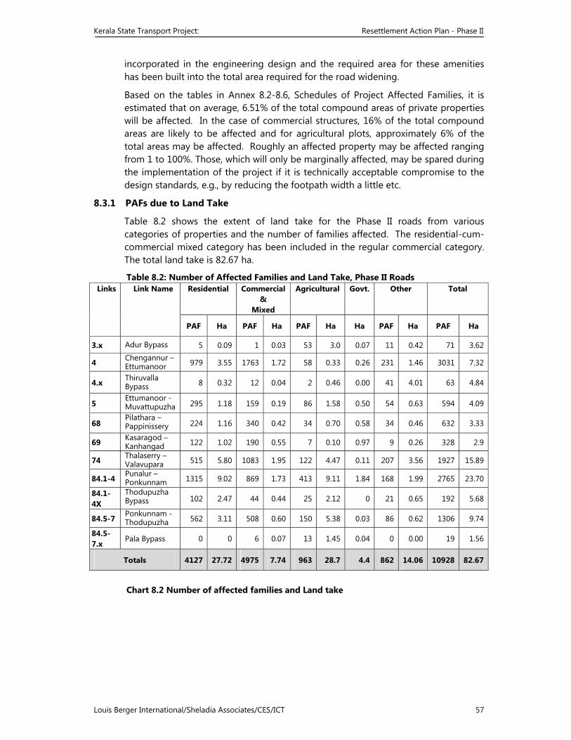
Kerala State Transport Project: Resettlement Action Plan - Phase II
Louis Berger International/Sheladia Associates/CES/ICT 57
incorporated in the engineering design and the required area for these amenities has been built into the total area required for the road widening.
Based on the tables in Annex 8.2-8.6, Schedules of Project Affected Families, it is estimated that on average, 6.51% of the total compound areas of private properties will be affected. In the case of commercial structures, 16% of the total compound areas are likely to be affected and for agricultural plots, approximately 6% of the total areas may be affected. Roughly an affected property may be affected ranging from 1 to 100%. Those, which will only be marginally affected, may be spared during the implementation of the project if it is technically acceptable compromise to the design standards, e.g., by reducing the footpath width a little etc.
8.3.1 PAFs due to Land Take
Table 8.2 shows the extent of land take for the Phase II roads from various categories of properties and the number of families affected. The residential-cum-commercial mixed category has been included in the regular commercial category. The total land take is 82.67 ha.
Table 8.2: Number of Affected Families and Land Take, Phase II Roads Links Link Name Residential Commercial
& Mixed
Agricultural Govt. Other Total
PAF Ha PAF Ha PAF Ha Ha PAF Ha PAF Ha
3.x Adur Bypass 5 0.09 1 0.03 53 3.0 0.07 11 0.42 71 3.62
4 Chengannur – Ettumanoor 979 3.55 1763 1.72 58 0.33 0.26 231 1.46 3031 7.32
4.x Thiruvalla Bypass 8 0.32 12 0.04 2 0.46 0.00 41 4.01 63 4.84
5 Ettumanoor -Muvattupuzha 295 1.18 159 0.19 86 1.58 0.50 54 0.63 594 4.09
68 Pilathara – Pappinissery 224 1.16 340 0.42 34 0.70 0.58 34 0.46 632 3.33
69 Kasaragod – Kanhangad 122 1.02 190 0.55 7 0.10 0.97 9 0.26 328 2.9
74 Thalaserry – Valavupara 515 5.80 1083 1.95 122 4.47 0.11 207 3.56 1927 15.89
84.1-4 Punalur – Ponkunnam 1315 9.02 869 1.73 413 9.11 1.84 168 1.99 2765 23.70
84.1-4X
Thodupuzha Bypass 102 2.47 44 0.44 25 2.12 0 21 0.65 192 5.68
84.5-7 Ponkunnam -Thodupuzha 562 3.11 508 0.60 150 5.38 0.03 86 0.62 1306 9.74
84.5-7.x Pala Bypass 0 0 6 0.07 13 1.45 0.04 0 0.00 19 1.56
Totals 4127 27.72 4975 7.74 963 28.7 4.4 862 14.06 10928 82.67
Chart 8.2 Number of affected families and Land take
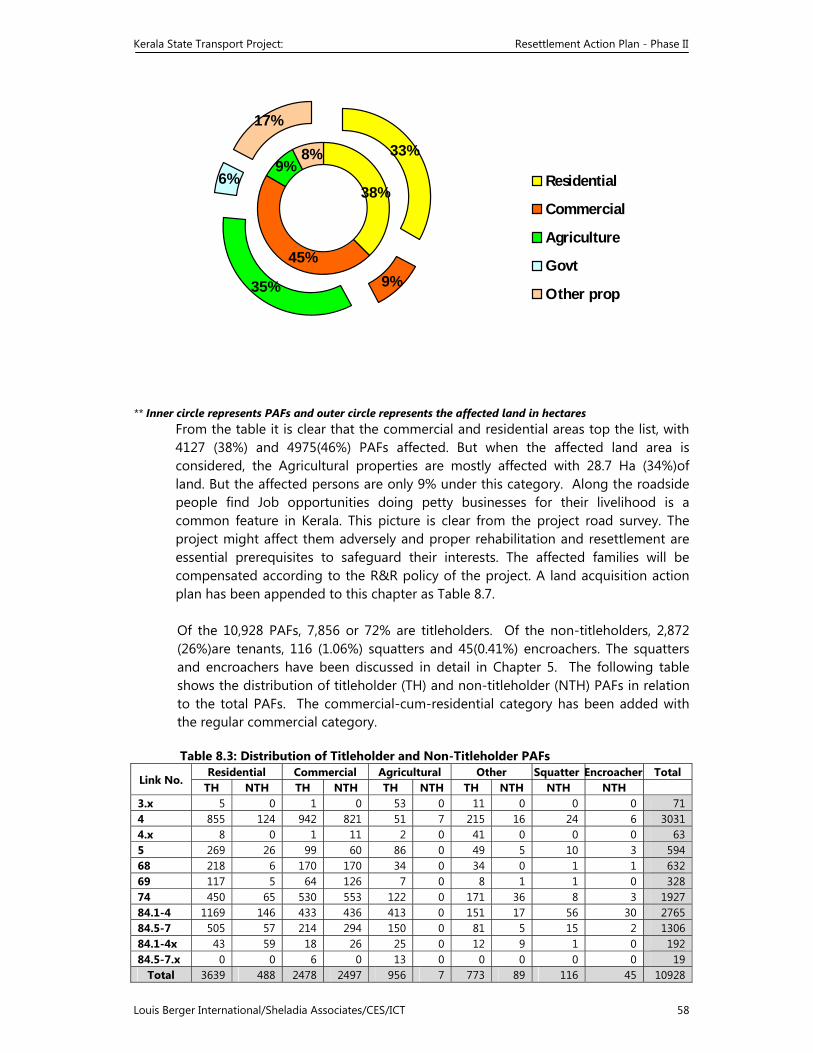
Kerala State Transport Project: Resettlement Action Plan - Phase II
Louis Berger International/Sheladia Associates/CES/ICT 58
38%
45%
9%8%
17%
6%
35% 9%
33%
Residential
Commercial
Agriculture
Govt
Other prop
** Inner circle represents PAFs and outer circle represents the affected land in hectares From the table it is clear that the commercial and residential areas top the list, with 4127 (38%) and 4975(46%) PAFs affected. But when the affected land area is considered, the Agricultural properties are mostly affected with 28.7 Ha (34%)of land. But the affected persons are only 9% under this category. Along the roadside people find Job opportunities doing petty businesses for their livelihood is a common feature in Kerala. This picture is clear from the project road survey. The project might affect them adversely and proper rehabilitation and resettlement are essential prerequisites to safeguard their interests. The affected families will be compensated according to the R&R policy of the project. A land acquisition action plan has been appended to this chapter as Table 8.7.
Of the 10,928 PAFs, 7,856 or 72% are titleholders. Of the non-titleholders, 2,872 (26%)are tenants, 116 (1.06%) squatters and 45(0.41%) encroachers. The squatters and encroachers have been discussed in detail in Chapter 5. The following table shows the distribution of titleholder (TH) and non-titleholder (NTH) PAFs in relation to the total PAFs. The commercial-cum-residential category has been added with the regular commercial category. Table 8.3: Distribution of Titleholder and Non-Titleholder PAFs
Link No. Residential Commercial Agricultural Other Squatter Encroacher Total
TH NTH TH NTH TH NTH TH NTH NTH NTH 3.x 5 0 1 0 53 0 11 0 0 0 71 4 855 124 942 821 51 7 215 16 24 6 30314.x 8 0 1 11 2 0 41 0 0 0 63 5 269 26 99 60 86 0 49 5 10 3 594 68 218 6 170 170 34 0 34 0 1 1 63269 117 5 64 126 7 0 8 1 1 0 32874 450 65 530 553 122 0 171 36 8 3 1927 84.1-4 1169 146 433 436 413 0 151 17 56 30 276584.5-7 505 57 214 294 150 0 81 5 15 2 130684.1-4x 43 59 18 26 25 0 12 9 1 0 192 84.5-7.x 0 0 6 0 13 0 0 0 0 0 19
Total 3639 488 2478 2497 956 7 773 89 116 45 10928
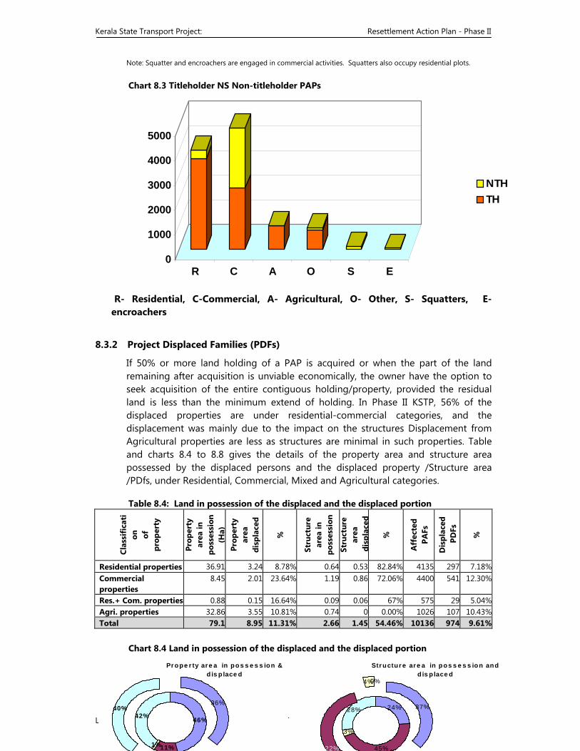
Kerala State Transport Project: Resettlement Action Plan - Phase II
Louis Berger International/Sheladia Associates/CES/ICT 59
Note: Squatter and encroachers are engaged in commercial activities. Squatters also occupy residential plots. Chart 8.3 Titleholder NS Non-titleholder PAPs
0
1000
2000
3000
4000
5000
R C A O S E
NTHTH
R- Residential, C-Commercial, A- Agricultural, O- Other, S- Squatters, E- encroachers
8.3.2 Project Displaced Families (PDFs)
If 50% or more land holding of a PAP is acquired or when the part of the land remaining after acquisition is unviable economically, the owner have the option to seek acquisition of the entire contiguous holding/property, provided the residual land is less than the minimum extend of holding. In Phase II KSTP, 56% of the displaced properties are under residential-commercial categories, and the displacement was mainly due to the impact on the structures Displacement from Agricultural properties are less as structures are minimal in such properties. Table and charts 8.4 to 8.8 gives the details of the property area and structure area possessed by the displaced persons and the displaced property /Structure area /PDfs, under Residential, Commercial, Mixed and Agricultural categories.
Table 8.4: Land in possession of the displaced and the displaced portion
Clas
sifi
cati
on
of
prop
erty
Prop
erty
ar
ea in
po
sses
sion
(Ha)
Pr
oper
ty
area
di
spla
ced
%
Stru
ctur
e
area
in
poss
essi
on
Stru
ctur
e
area
di
spla
ced
%
Aff
ecte
d
PAFs
Dis
plac
ed
PD
Fs
%
Residential properties 36.91 3.24 8.78% 0.64 0.53 82.84% 4135 297 7.18%Commercial properties
8.45 2.01 23.64% 1.19 0.86 72.06% 4400 541 12.30%
Res.+ Com. properties 0.88 0.15 16.64% 0.09 0.06 67% 575 29 5.04%Agri. properties 32.86 3.55 10.81% 0.74 0 0.00% 1026 107 10.43%Total 79.1 8.95 11.31% 2.66 1.45 54.46% 10136 974 9.61%
Chart 8.4 Land in possession of the displaced and the displaced portion
Pr ope r ty ar e a in po s s e s s ion & d is p lace d
46%
11%1%
42%
36%40%
Str uctur e ar e a in po s s e s s ion and d is p lace d
24%
45%
3%
28% 37%
4%0%
22%
Kerala State Transport Project: Resettlement Action Plan - Phase II
Louis Berger International/Sheladia Associates/CES/ICT 60
Link wise details of such displacements in various categories of properties are clear from the following tables and graphs.
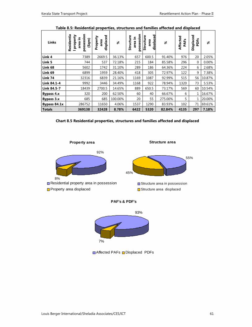
Kerala State Transport Project: Resettlement Action Plan - Phase II
Louis Berger International/Sheladia Associates/CES/ICT 61
Table 8.5: Residential properties, structures and families affected and displaced
Links
Resi
dent
ial p
rope
rty
area
in
poss
essi
on
(Sqm
)
Prop
erty
ar
ea
disp
lace
d
%
Stru
ctur
e a
rea
in
poss
essi
on
Stru
ctur
e
area
d
ispl
aced
%
Aff
ecte
d PA
Fs
Dis
plac
ed
PD
Fs
%
Link 4 7389 2669.5 36.13% 657 600.5 91.40% 976 20 2.05% Link 5 744 537 72.18% 215 184 85.58% 296 0 0.00% Link 68 5602 1742 31.10% 289 186 64.36% 224 6 2.68% Link 69 6899 1959 28.40% 418 305 72.97% 122 9 7.38% Link 74 32316 6839 21.16% 1169 1087 92.99% 515 56 10.87% Link 84.1-4 9992 3446 34.49% 1168 922 78.94% 1320 73 5.53% Link 84.5-7 18439 2700.5 14.65% 889 650.5 73.17% 569 60 10.54% Bypass 4.x 320 200 62.50% 60 40 66.67% 6 1 16.67% Bypass 3.x 685 685 100.00% 20 55 275.00% 5 1 20.00% Bypass 84.1x 286752 11650 4.06% 1537 1290 83.93% 102 71 69.61% Totals 369138 32428 8.78% 6422 5320 82.84% 4135 297 7.18%
Chart 8.5 Residential properties, structures and families affected and displaced
Property area
92%
8%Residential property area in possession Property area displaced
Structure area
55%
45%
Structure area in possession
Structure area displaced
PAF's & PDF's
93%
7%
Affected PAFs Displaced PDFs
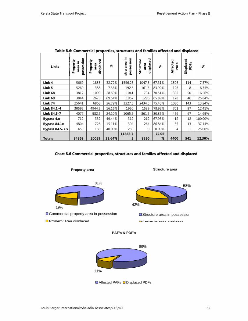
Kerala State Transport Project: Resettlement Action Plan - Phase II
Louis Berger International/Sheladia Associates/CES/ICT 62
Table 8.6: Commercial properties, structures and families affected and displaced
Links Co
mm
erci
al
Prop
erty
ar
ea in
po
sses
sion
(S
M)
Prop
erty
ar
ea
disp
lace
d
%
stru
are
a in
po
sses
sion
Stru
ctur
e
area
d
ispl
aced
%
Aff
ecte
d
PAFs
Dis
plac
ed
PD
Fs
%
Link 4 5669 1855 32.72% 1556.25 1047.5 67.31% 1506 114 7.57% Link 5 5269 388 7.36% 192.5 161.5 83.90% 126 8 6.35% Link 68 3812 1090 28.59% 1041 734 70.51% 302 50 16.56% Link 69 3844 2673 69.54% 1967 1296 65.89% 178 46 25.84% Link 74 25641 6868 26.79% 3227.5 2434.5 75.43% 1080 143 13.24% Link 84.1-4 30592 4944.5 16.16% 1950 1539 78.92% 701 87 12.41% Link 84.5-7 4077 982.5 24.10% 1065.5 861.5 80.85% 456 67 14.69% Bypass 4.x 712 352 49.44% 312 212 67.95% 12 12 100.00% Bypass 84.1x 4804 726 15.11% 304 264 86.84% 35 13 37.14% Bypass 84.5-7.x 450 180 40.00% 250 0 0.00% 4 1 25.00%
Totals 84869 20059 23.64%11865.7
5 8550 72.06
% 4400 541 12.30%
Chart 8.6 Commercial properties, structures and families affected and displaced
Property area
81%
19%
Commercial property area in possession
Property area displaced
Structure area
58%
42%
Structure area in possession
Structure area displaced
PAF's & PDF's
89%
11%
Affected PAFs Displaced PDFs
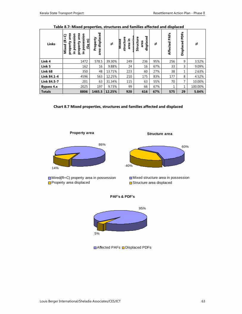
Kerala State Transport Project: Resettlement Action Plan - Phase II
Louis Berger International/Sheladia Associates/CES/ICT 63
Table 8.7: Mixed properties, structures and families affected and displaced
Links
Mix
ed (R
+C)
pr
oper
ty a
rea
in p
osse
ssio
n pr
oper
ty a
rea
in
pos
sess
ion
(Sq
m)
Prop
erty
ar
ea d
ispl
aced
%
Mix
ed
stru
ctur
e
area
in
poss
essi
onSt
ruct
ure
ar
ea
dis
plac
ed
%
Aff
ecte
d PA
Fs
Dis
plac
ed P
DFs
%
Link 4 1472 578.5 39.30% 249 236 95% 256 9 3.52%Link 5 162 16 9.88% 24 16 67% 33 3 9.09%Link 68 350 48 13.71% 223 60 27% 38 1 2.63%Link 84.1-4 4596 563 12.25% 210 175 83% 177 8 4.52%Link 84.5-7 201 63 31.34% 115 63 55% 70 7 10.00%Bypass 4.x 2025 197 9.73% 99 66 67% 1 1 100.00%Totals 8806 1465.5 12.25% 920 616 67% 575 29 5.04%
Chart 8.7 Mixed properties, structures and families affected and displaced
Structure area
60%
40%
Mixed structure area in possession Structure area displaced
Property area
86%
14%
Mired(R+C) property area in possession Property area displaced
PAF's & PDF's
95%
5%
Affected PAFs Displaced PDFs
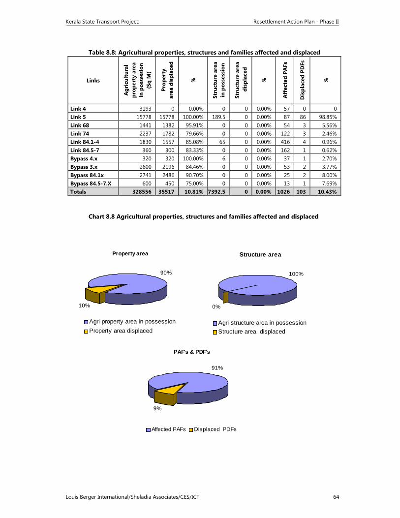
Kerala State Transport Project: Resettlement Action Plan - Phase II
Louis Berger International/Sheladia Associates/CES/ICT 64
Table 8.8: Agricultural properties, structures and families affected and displaced
Links
Agr
icul
tura
l pr
oper
ty a
rea
in
pos
sess
ion
(Sq
M)
Prop
erty
ar
ea d
ispl
aced
%
Stru
ctur
e ar
ea
in p
osse
ssio
n
Stru
ctur
e ar
ea
dis
plac
ed
%
Aff
ecte
d PA
Fs
Dis
plac
ed P
DFs
%
Link 4 3193 0 0.00% 0 0 0.00% 57 0 0 Link 5 15778 15778 100.00% 189.5 0 0.00% 87 86 98.85% Link 68 1441 1382 95.91% 0 0 0.00% 54 3 5.56% Link 74 2237 1782 79.66% 0 0 0.00% 122 3 2.46% Link 84.1-4 1830 1557 85.08% 65 0 0.00% 416 4 0.96% Link 84.5-7 360 300 83.33% 0 0 0.00% 162 1 0.62% Bypass 4.x 320 320 100.00% 6 0 0.00% 37 1 2.70% Bypass 3.x 2600 2196 84.46% 0 0 0.00% 53 2 3.77% Bypass 84.1x 2741 2486 90.70% 0 0 0.00% 25 2 8.00% Bypass 84.5-7.X 600 450 75.00% 0 0 0.00% 13 1 7.69% Totals 328556 35517 10.81% 7392.5 0 0.00% 1026 103 10.43%
Chart 8.8 Agricultural properties, structures and families affected and displaced
Property area
90%
10%
Agri property area in possession Property area displaced
Structure area
100%
0%
Agri structure area in possession Structure area displaced
PAF's & PDF's
91%
9%
Affected PAFs Displaced PDFs
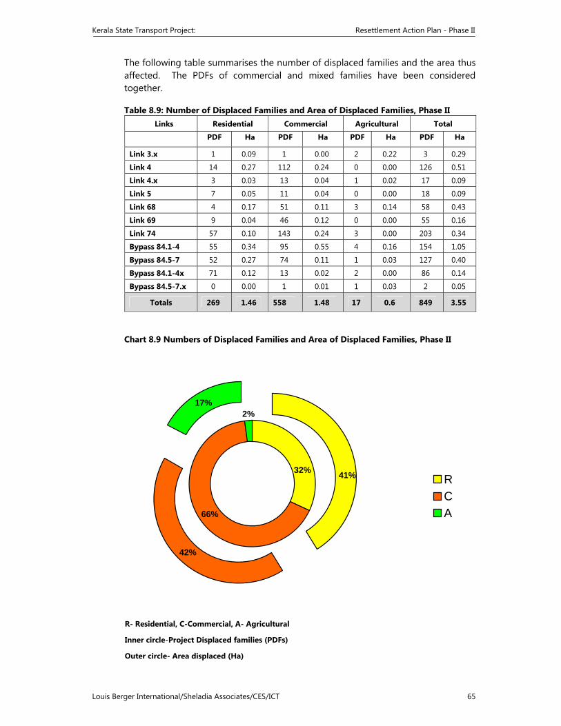
Kerala State Transport Project: Resettlement Action Plan - Phase II
Louis Berger International/Sheladia Associates/CES/ICT 65
The following table summarises the number of displaced families and the area thus affected. The PDFs of commercial and mixed families have been considered together.
Table 8.9: Number of Displaced Families and Area of Displaced Families, Phase II Links Residential Commercial Agricultural Total
PDF Ha PDF Ha PDF Ha PDF Ha
Link 3.x 1 0.09 1 0.00 2 0.22 3 0.29
Link 4 14 0.27 112 0.24 0 0.00 126 0.51
Link 4.x 3 0.03 13 0.04 1 0.02 17 0.09
Link 5 7 0.05 11 0.04 0 0.00 18 0.09
Link 68 4 0.17 51 0.11 3 0.14 58 0.43
Link 69 9 0.04 46 0.12 0 0.00 55 0.16
Link 74 57 0.10 143 0.24 3 0.00 203 0.34
Bypass 84.1-4 55 0.34 95 0.55 4 0.16 154 1.05
Bypass 84.5-7 52 0.27 74 0.11 1 0.03 127 0.40
Bypass 84.1-4x 71 0.12 13 0.02 2 0.00 86 0.14
Bypass 84.5-7.x 0 0.00 1 0.01 1 0.03 2 0.05
Totals 269 1.46 558 1.48 17 0.6 849 3.55
Chart 8.9 Numbers of Displaced Families and Area of Displaced Families, Phase II
66%
42%
17%
32%
2%
41% RCA
R- Residential, C-Commercial, A- Agricultural
Inner circle-Project Displaced families (PDFs)
Outer circle- Area displaced (Ha)
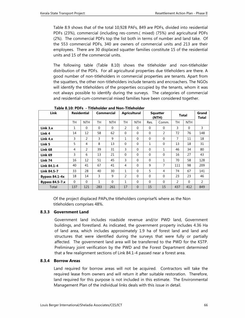
Kerala State Transport Project: Resettlement Action Plan - Phase II
Louis Berger International/Sheladia Associates/CES/ICT 66
Table 8.9 shows that of the total 10,928 PAFs, 849 are PDFs, divided into residential PDFs (23%), commercial (including res-comm.( mixed) (75%) and agricultural PDFs (2%). The commercial PDFs top the list both in terms of number and land take. Of the 553 commercial PDFs, 340 are owners of commercial units and 213 are their employees. There are 30 displaced squatter families constitute 15 of the residential units and 15 of the commercial units.
The following table (Table 8.10) shows the titleholder and non-titleholder distribution of the PDFs. For all agricultural properties due titleholders are there. A good number of non-titleholders in commercial properties are tenants. Apart from the squatters, the other non-titleholders include tenants and encroachers. The NGOs will identify the titleholders of the properties occupied by the tenants, whom it was not always possible to identify during the surveys. The categories of commercial and residential-cum-commercial mixed families have been considered together.
Table 8.10: PDFs - Titleholder and Non-Titleholder Link Residential Commercial Agricultural Squatter
(NTH) Total
Grand Total
TH NTH TH NTH TH NTH Res. Comm. TH NTH
Link 3.x 1 0 0 0 2 0 0 0 3 0 3
Link 4 14 12 58 62 0 0 0 2 72 76 148
Link 4.x 3 2 3 9 1 0 0 0 7 11 18
Link 5 5 4 8 13 0 0 1 0 13 18 31
Link 68 4 2 39 31 3 0 0 1 46 34 80
Link 69 3 6 13 21 0 0 0 0 16 27 43
Link 74 16 12 51 45 3 0 0 1 70 58 128
Link 84.1-4 40 41 67 41 4 0 9 7 111 98 209
Link 84.5-7 33 28 40 30 1 0 5 4 74 67 141
Bypass 84.1-4x 18 14 3 9 2 0 0 0 23 23 46
Bypass 84.5-7.x 0 0 1 0 1 0 0 0 2 0 2 Total 137 121 283 261 17 0 15 15 437 412 849
Of the project displaced PAPs,the titleholders comprise% where as the Non titleholders comprises 48%.
8.3.3 Government Land
Government land includes roadside revenue and/or PWD land, Government buildings, and forestland. As indicated, the government property includes 4.36 Ha of land area, which includes approximately 1.9 ha of forest land and land and structures that were identified during the surveys that were fully or partially affected. The government land area will be transferred to the PWD for the KSTP. Preliminary joint verification by the PWD and the Forest Department determined that a few realignment sections of Link 84.1-4 passed near a forest area.
8.3.4 Borrow Areas
Land required for borrow areas will not be acquired. Contractors will take the required lease from owners and will return it after suitable restoration. Therefore, land required for this purpose is not included in this estimate. The Environmental Management Plan of the individual links deals with this issue in detail.
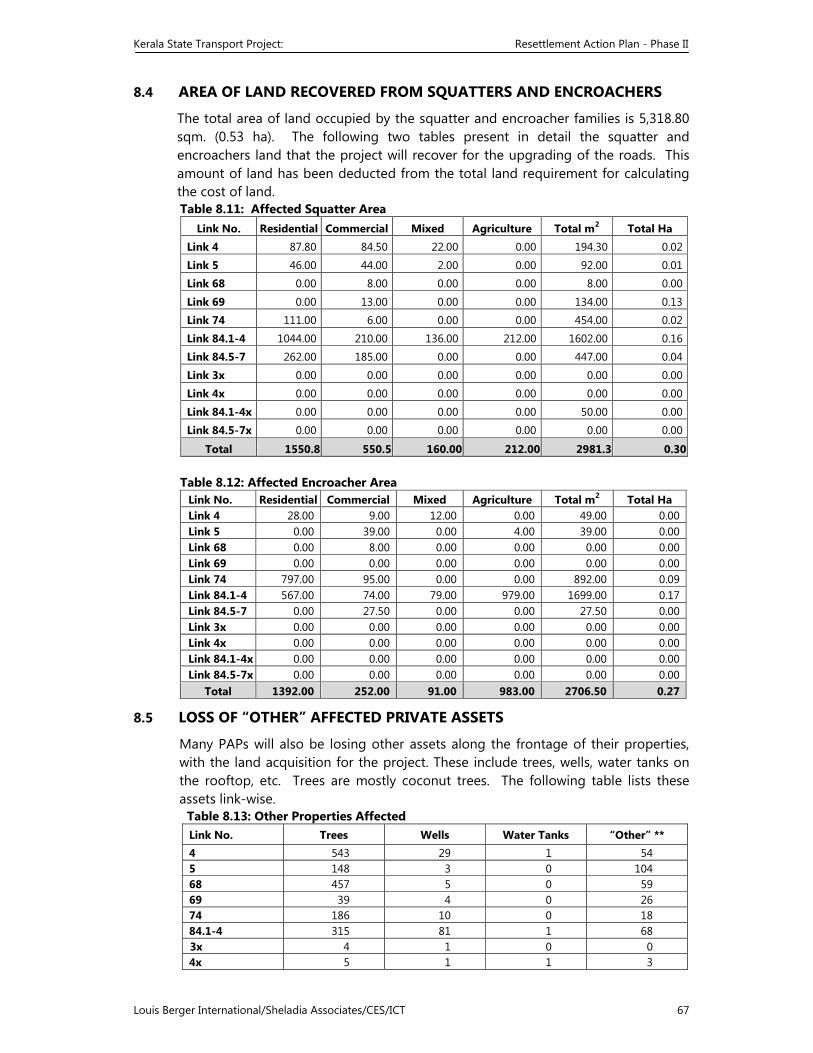
Kerala State Transport Project: Resettlement Action Plan - Phase II
Louis Berger International/Sheladia Associates/CES/ICT 67
8.4 AREA OF LAND RECOVERED FROM SQUATTERS AND ENCROACHERS
The total area of land occupied by the squatter and encroacher families is 5,318.80 sqm. (0.53 ha). The following two tables present in detail the squatter and encroachers land that the project will recover for the upgrading of the roads. This amount of land has been deducted from the total land requirement for calculating the cost of land. Table 8.11: Affected Squatter Area
Link No. Residential Commercial Mixed Agriculture Total m2 Total Ha Link 4 87.80 84.50 22.00 0.00 194.30 0.02
Link 5 46.00 44.00 2.00 0.00 92.00 0.01Link 68 0.00 8.00 0.00 0.00 8.00 0.00
Link 69 0.00 13.00 0.00 0.00 134.00 0.13Link 74 111.00 6.00 0.00 0.00 454.00 0.02
Link 84.1-4 1044.00 210.00 136.00 212.00 1602.00 0.16Link 84.5-7 262.00 185.00 0.00 0.00 447.00 0.04
Link 3x 0.00 0.00 0.00 0.00 0.00 0.00
Link 4x 0.00 0.00 0.00 0.00 0.00 0.00
Link 84.1-4x 0.00 0.00 0.00 0.00 50.00 0.00
Link 84.5-7x 0.00 0.00 0.00 0.00 0.00 0.00
Total 1550.8 550.5 160.00 212.00 2981.3 0.30 Table 8.12: Affected Encroacher Area
Link No. Residential Commercial Mixed Agriculture Total m2 Total Ha Link 4 28.00 9.00 12.00 0.00 49.00 0.00Link 5 0.00 39.00 0.00 4.00 39.00 0.00Link 68 0.00 8.00 0.00 0.00 0.00 0.00Link 69 0.00 0.00 0.00 0.00 0.00 0.00Link 74 797.00 95.00 0.00 0.00 892.00 0.09Link 84.1-4 567.00 74.00 79.00 979.00 1699.00 0.17Link 84.5-7 0.00 27.50 0.00 0.00 27.50 0.00Link 3x 0.00 0.00 0.00 0.00 0.00 0.00Link 4x 0.00 0.00 0.00 0.00 0.00 0.00Link 84.1-4x 0.00 0.00 0.00 0.00 0.00 0.00Link 84.5-7x 0.00 0.00 0.00 0.00 0.00 0.00
Total 1392.00 252.00 91.00 983.00 2706.50 0.27
8.5 LOSS OF “OTHER” AFFECTED PRIVATE ASSETS
Many PAPs will also be losing other assets along the frontage of their properties, with the land acquisition for the project. These include trees, wells, water tanks on the rooftop, etc. Trees are mostly coconut trees. The following table lists these assets link-wise. Table 8.13: Other Properties Affected
Link No. Trees Wells Water Tanks “Other” ** 4 543 29 1 54 5 148 3 0 104 68 457 5 0 59 69 39 4 0 26 74 186 10 0 18 84.1-4 315 81 1 68 3x 4 1 0 0 4x 5 1 1 3
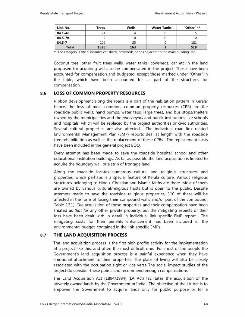
Kerala State Transport Project: Resettlement Action Plan - Phase II
Louis Berger International/Sheladia Associates/CES/ICT 68
Link No. Trees Wells Water Tanks “Other” ** 84.1-4x 21 4 0 5 84.5-7x 2 0 0 0 84.5-7 106 25 0 181
Total 1826 163 3 518 ** The category “Other” includes car sheds, cowsheds, shops adjacent to the main building, etc.
Coconut tree, other fruit trees wells, water tanks, cowsheds, car etc in the land proposed for acquiring will also be compensated in the project. These have been accounted for compensation and budgeted, except those marked under “Other” in the table, which have been accounted for as part of the structures for compensation.
8.6 LOSS OF COMMON PROPERTY RESOURCES
Ribbon development along the roads is a part of the habitation pattern in Kerala; hence, the loss of most common, common property resources (CPR) are the roadside public wells, hand pumps, water taps, large trees, and bus stops/shelters owned by the municipalities and the panchayats and public institutions like schools and hospitals, which will be replaced by the project authorities or civic authorities. Several cultural properties are also affected. The individual road link related Environmental Management Plan (EMP) reports deal at length with the roadside tree rehabilitation as well as the replacement of these CPRs. The replacement costs have been included in the general project BOQ.
Every attempt has been made to save the roadside hospital, school and other educational institution buildings. As far as possible the land acquisition is limited to acquire the boundary wall or a strip of frontage land.
Along the roadside locates numerous cultural and religious structures and properties, which perhaps is a special feature of Kerala culture. Various religious structures belonging to Hindu, Christian and Islamic faiths are there. Most of them are owned by various cultural/religious trusts but is open to the public. Despite attempts made to save the roadside religious properties, 110 of these will be affected in the form of losing their compound walls and/or part of the compound( Table-17.1). The acquisition of these properties and their compensation have been treated as that for any other private property, but the mitigating aspects of their loss have been dealt with in detail in individual link specific EMP report. The mitigating costs for their benefits enhancement has been included in the environmental budget, contained in the link-specific EMPs.
8.7 THE LAND ACQUISITION PROCESS
The land acquisition process is the first high profile activity for the implementation of a project like this, and often the most difficult one. For most of the people the Government’s land acquisition process is a painful experience when they have emotional attachment to their properties. The place of living will also be closely associated with the occupation sight or vice versa The social impact studies of the project do consider these points and recommend enough compensations.
The Land Acquisition Act [1894/1984] (LA Act) facilitates the acquisition of the privately owned lands by the Government in India. The objective of the LA Act is to empower the Government to acquire lands only for public purpose or for a
Kerala State Transport Project: Resettlement Action Plan - Phase II
Louis Berger International/Sheladia Associates/CES/ICT 69
company. If lands are needed for a public purpose they cannot be acquired by an executive action without following the provisions of the LA Act. The provisions of the Act will apply only to the private lands. There are separate rules for alienation or transfer of Government land in favour of any other Government department for public purposes. The land acquisition process has been presented in a flow chart as follows. The respective responsibilities, indicative numerical months and actual months for performing a given task, and the relevant sections of the Land Acquisition Act have been indicated.
The time frame for land acquisition shown in the land acquisition process flow chart and in Table 8.9 integrates the environmental clearance requirements in respect of Link 68 and Link 69 for the CRZ (coastal regulation zone) and STEC (State Committee on Science, Technology and Environment) and MoEF (Ministry of Environment and Forest) clearance for Link 84.1-4. The environmental procedures will take four months to complete and integrated with the land acquisition process as shown in the land acquisition process flow chart. This matter has been dealt with in the KSTP’s Environmental Impact Assessment (EIA) report for the Phase II roads.
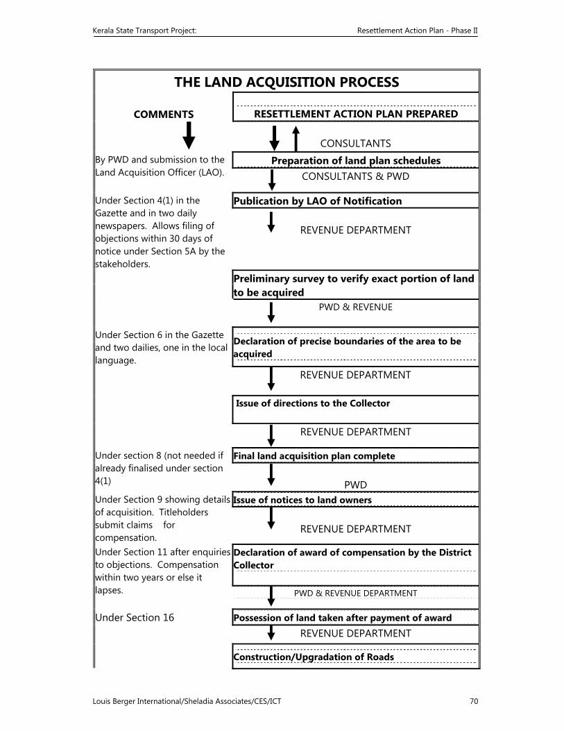
Kerala State Transport Project: Resettlement Action Plan - Phase II
Louis Berger International/Sheladia Associates/CES/ICT 70
THE LAND ACQUISITION PROCESS
COMMENTS RESETTLEMENT ACTION PLAN PREPARED
CONSULTANTS
By PWD and submission to the Land Acquisition Officer (LAO).
Preparation of land plan schedules CONSULTANTS & PWD
Under Section 4(1) in the Gazette and in two daily newspapers. Allows filing of objections within 30 days of notice under Section 5A by the stakeholders.
Publication by LAO of Notification
REVENUE DEPARTMENT
Preliminary survey to verify exact portion of land to be acquired
PWD & REVENUE
Under Section 6 in the Gazette and two dailies, one in the local language.
Declaration of precise boundaries of the area to be acquired
REVENUE DEPARTMENT
Issue of directions to the Collector
REVENUE DEPARTMENT
Under section 8 (not needed if already finalised under section 4(1)
Final land acquisition plan complete
PWD Under Section 9 showing details of acquisition. Titleholders submit claims for compensation.
Issue of notices to land owners
REVENUE DEPARTMENT
Under Section 11 after enquiries to objections. Compensation within two years or else it lapses.
Declaration of award of compensation by the District Collector
PWD & REVENUE DEPARTMENT
Under Section 16
Possession of land taken after payment of award
REVENUE DEPARTMENT
Construction/Upgradation of Roads
Kerala State Transport Project: Resettlement Action Plan - Phase II
Louis Berger International/Sheladia Associates/CES/ICT 71
PUBLIC WORKS DEPARTMENT
Kerala State Transport Project: Resettlement Action Plan - Phase II
Louis Berger International/Sheladia Associates/CES/ICT 72
8.7.1 Case Studies on Land Acquisition by the Kerala PWD
In recent years the Kerala PWD has acquired private land for the improvement of the national highways. Two major problems for land acquisition have been experienced in this regard. First, litigation by the affected persons and secondly, delays incurred in the completion of formalities at various stages. As the works on the national highways assume a great importance in the national road network and the funds from the Government of India have to be utilised during the allotted financial years, the land acquisition process has to be completed most expeditiously. In order to minimise the delay in getting the land under possession, the urgency clause of the LA Act is routinely invoked. In such a case, a composite notification in the prescribed form is published, as required by the sub-section 4(1) and 17(4) of the LA Act. The following two examples demonstrate the processes and delays in land acquisition by the PWD: (1) In LAC No. 1/2000, in respect of widening of MC Road at Kesavadasapuram
– PMG, area 0.0036 ares: Date of requisition : 10 November 1997 Date of 4(1) notification : 12 January 1999 Date of declaration : 6 January 2000 Date of taking possession : 3 February 2000 Date of award : 1 May 2001
(2) In LAC No. 97/98, construction of a bridge over the Karamana River, area 9.09 ares:
Date of requisition : 14 January 1998 Date of 4(1) notification : 29 July 1998 Date of declaration : 15 October 1998 Date of taking possession : 30 December 1998 Date of award : 28 May 1999
In some earlier cases, such as the ADB assisted Kochi Bypass (from Edapally to Aluva, NH-47, length 46 km), although the District Collector awarded compensation, estimated at Rs. 48 million in 1988-89, the litigations continued and finally the courts awarded an estimated Rs. 360 million in 1999 as final settlement. Similarly, in the case of Kollam Bypass (NH-47), the original estimated compensation in 1986 was Rs. 13.9 million, but due to litigation the courts awarded Rs. 21.1 million as final settlement in 1992.9 In all these cases the urgency clause for land acquisition was invoked.
The KSTP will follow the normal procedure of land acquisition under the LA Act. Currently the PMT is processing the formalities for the acquisition of land for the implementation of the Phase I roads upgrading works. An action plan for land acquisition for the Phase II roads is presented in Table 8.9. An IAS officer from the State Revenue Department has been deputed to the PMT as Director of Land
9 Information obtained from National Highway Wing of the Kerala PWD.
Kerala State Transport Project: Resettlement Action Plan - Phase II
Louis Berger International/Sheladia Associates/CES/ICT 73
Acquisition, with the powers of a District Collector, to expedite the land acquisition process.
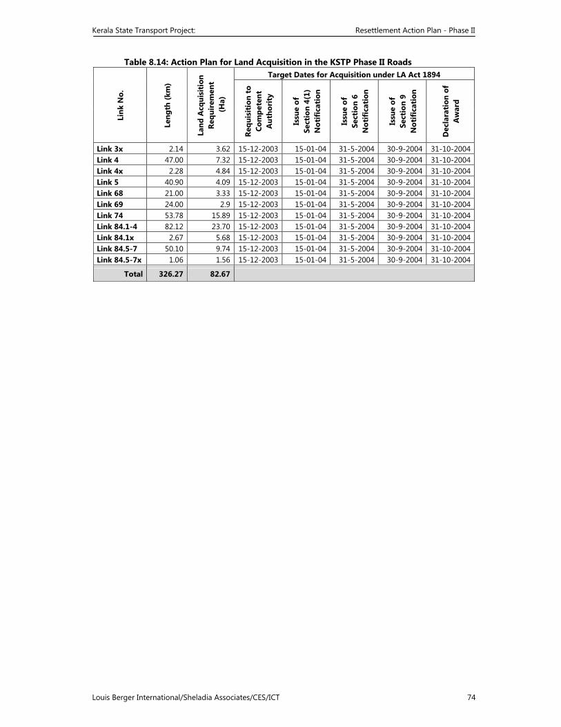
Kerala State Transport Project: Resettlement Action Plan - Phase II
Louis Berger International/Sheladia Associates/CES/ICT 74
Table 8.14: Action Plan for Land Acquisition in the KSTP Phase II Roads
Link
No.
Leng
th (k
m)
Land
Acq
uisi
tion
Re
quir
emen
t (H
a)
Target Dates for Acquisition under LA Act 1894
Requ
isit
ion
to
Com
pete
nt
Aut
hori
ty
Issu
e of
Se
ctio
n 4(
1)
Not
ific
atio
n
Issu
e of
Se
ctio
n 6
Not
ific
atio
n
Issu
e of
Se
ctio
n 9
Not
ific
atio
n
Dec
lara
tion
of
Aw
ard
Link 3x 2.14 3.62 15-12-2003 15-01-04 31-5-2004 30-9-2004 31-10-2004Link 4 47.00 7.32 15-12-2003 15-01-04 31-5-2004 30-9-2004 31-10-2004Link 4x 2.28 4.84 15-12-2003 15-01-04 31-5-2004 30-9-2004 31-10-2004Link 5 40.90 4.09 15-12-2003 15-01-04 31-5-2004 30-9-2004 31-10-2004Link 68 21.00 3.33 15-12-2003 15-01-04 31-5-2004 30-9-2004 31-10-2004Link 69 24.00 2.9 15-12-2003 15-01-04 31-5-2004 30-9-2004 31-10-2004Link 74 53.78 15.89 15-12-2003 15-01-04 31-5-2004 30-9-2004 31-10-2004Link 84.1-4 82.12 23.70 15-12-2003 15-01-04 31-5-2004 30-9-2004 31-10-2004Link 84.1x 2.67 5.68 15-12-2003 15-01-04 31-5-2004 30-9-2004 31-10-2004Link 84.5-7 50.10 9.74 15-12-2003 15-01-04 31-5-2004 30-9-2004 31-10-2004Link 84.5-7x 1.06 1.56 15-12-2003 15-01-04 31-5-2004 30-9-2004 31-10-2004
Total 326.27 82.67
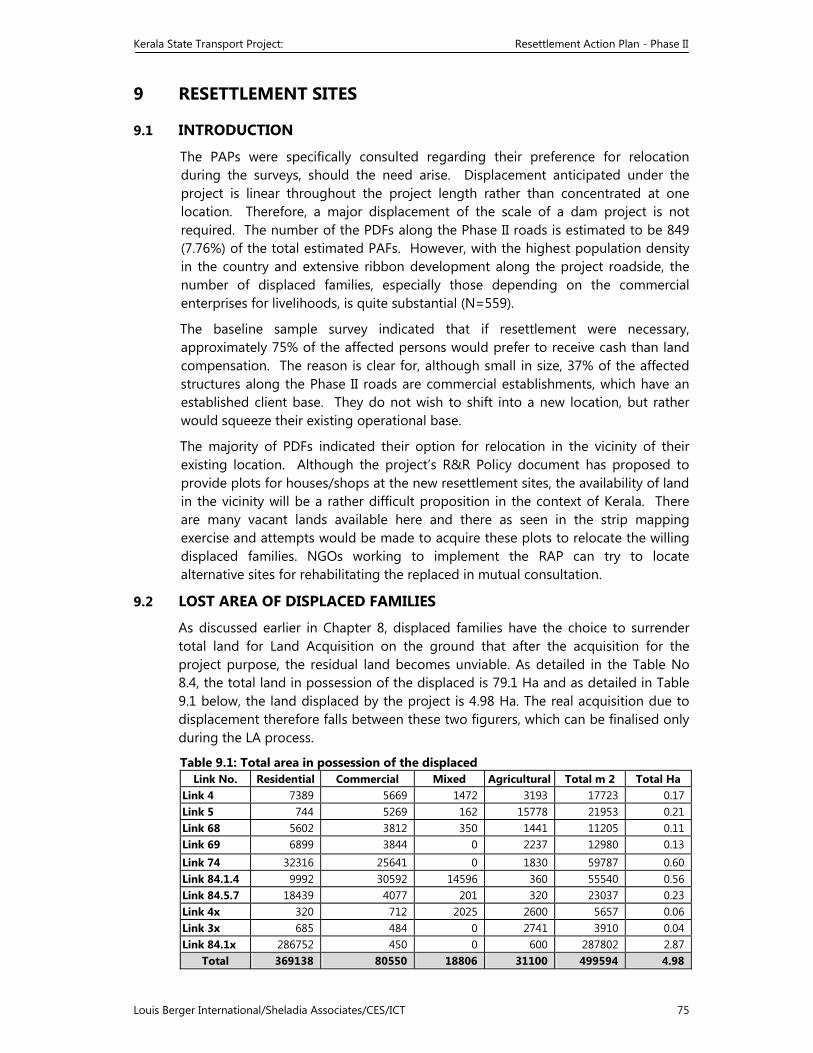
Kerala State Transport Project: Resettlement Action Plan - Phase II
Louis Berger International/Sheladia Associates/CES/ICT 75
9 RESETTLEMENT SITES
9.1 INTRODUCTION
The PAPs were specifically consulted regarding their preference for relocation during the surveys, should the need arise. Displacement anticipated under the project is linear throughout the project length rather than concentrated at one location. Therefore, a major displacement of the scale of a dam project is not required. The number of the PDFs along the Phase II roads is estimated to be 849 (7.76%) of the total estimated PAFs. However, with the highest population density in the country and extensive ribbon development along the project roadside, the number of displaced families, especially those depending on the commercial enterprises for livelihoods, is quite substantial (N=559).
The baseline sample survey indicated that if resettlement were necessary, approximately 75% of the affected persons would prefer to receive cash than land compensation. The reason is clear for, although small in size, 37% of the affected structures along the Phase II roads are commercial establishments, which have an established client base. They do not wish to shift into a new location, but rather would squeeze their existing operational base.
The majority of PDFs indicated their option for relocation in the vicinity of their existing location. Although the project’s R&R Policy document has proposed to provide plots for houses/shops at the new resettlement sites, the availability of land in the vicinity will be a rather difficult proposition in the context of Kerala. There are many vacant lands available here and there as seen in the strip mapping exercise and attempts would be made to acquire these plots to relocate the willing displaced families. NGOs working to implement the RAP can try to locate alternative sites for rehabilitating the replaced in mutual consultation.
9.2 LOST AREA OF DISPLACED FAMILIES
As discussed earlier in Chapter 8, displaced families have the choice to surrender total land for Land Acquisition on the ground that after the acquisition for the project purpose, the residual land becomes unviable. As detailed in the Table No 8.4, the total land in possession of the displaced is 79.1 Ha and as detailed in Table 9.1 below, the land displaced by the project is 4.98 Ha. The real acquisition due to displacement therefore falls between these two figurers, which can be finalised only during the LA process.
Table 9.1: Total area in possession of the displaced Link No. Residential Commercial Mixed Agricultural Total m 2 Total Ha
Link 4 7389 5669 1472 3193 17723 0.17 Link 5 744 5269 162 15778 21953 0.21 Link 68 5602 3812 350 1441 11205 0.11Link 69 6899 3844 0 2237 12980 0.13Link 74 32316 25641 0 1830 59787 0.60 Link 84.1.4 9992 30592 14596 360 55540 0.56 Link 84.5.7 18439 4077 201 320 23037 0.23Link 4x 320 712 2025 2600 5657 0.06Link 3x 685 484 0 2741 3910 0.04Link 84.1x 286752 450 0 600 287802 2.87
Total 369138 80550 18806 31100 499594 4.98
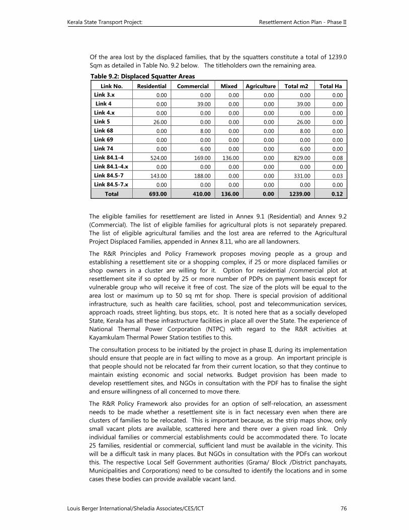
Kerala State Transport Project: Resettlement Action Plan - Phase II
Louis Berger International/Sheladia Associates/CES/ICT 76
Of the area lost by the displaced families, that by the squatters constitute a total of 1239.0 Sqm as detailed in Table No. 9.2 below. The titleholders own the remaining area.
Table 9.2: Displaced Squatter Areas Link No. Residential Commercial Mixed Agriculture Total m2 Total Ha
Link 3.x 0.00 0.00 0.00 0.00 0.00 0.00 Link 4 0.00 39.00 0.00 0.00 39.00 0.00 Link 4.x 0.00 0.00 0.00 0.00 0.00 0.00 Link 5 26.00 0.00 0.00 0.00 26.00 0.00 Link 68 0.00 8.00 0.00 0.00 8.00 0.00 Link 69 0.00 0.00 0.00 0.00 0.00 0.00 Link 74 0.00 6.00 0.00 0.00 6.00 0.00 Link 84.1-4 524.00 169.00 136.00 0.00 829.00 0.08 Link 84.1-4.x 0.00 0.00 0.00 0.00 0.00 0.00 Link 84.5-7 143.00 188.00 0.00 0.00 331.00 0.03 Link 84.5-7.x 0.00 0.00 0.00 0.00 0.00 0.00
Total 693.00 410.00 136.00 0.00 1239.00 0.12
The eligible families for resettlement are listed in Annex 9.1 (Residential) and Annex 9.2 (Commercial). The list of eligible families for agricultural plots is not separately prepared. The list of eligible agricultural families and the lost area are referred to the Agricultural Project Displaced Families, appended in Annex 8.11, who are all landowners.
The R&R Principles and Policy Framework proposes moving people as a group and establishing a resettlement site or a shopping complex, if 25 or more displaced families or shop owners in a cluster are willing for it. Option for residential /commercial plot at resettlement site if so opted by 25 or more number of PDPs on payment basis except for vulnerable group who will receive it free of cost. The size of the plots will be equal to the area lost or maximum up to 50 sq mt for shop. There is special provision of additional infrastructure, such as health care facilities, school, post and telecommunication services, approach roads, street lighting, bus stops, etc. It is noted here that as a socially developed State, Kerala has all these infrastructure facilities in place all over the State. The experience of National Thermal Power Corporation (NTPC) with regard to the R&R activities at Kayamkulam Thermal Power Station testifies to this.
The consultation process to be initiated by the project in phase II, during its implementation should ensure that people are in fact willing to move as a group. An important principle is that people should not be relocated far from their current location, so that they continue to maintain existing economic and social networks. Budget provision has been made to develop resettlement sites, and NGOs in consultation with the PDF has to finalise the sight and ensure willingness of all concerned to move there.
The R&R Policy Framework also provides for an option of self-relocation, an assessment needs to be made whether a resettlement site is in fact necessary even when there are clusters of families to be relocated. This is important because, as the strip maps show, only small vacant plots are available, scattered here and there over a given road link. Only individual families or commercial establishments could be accommodated there. To locate 25 families, residential or commercial, sufficient land must be available in the vicinity. This will be a difficult task in many places. But NGOs in consultation with the PDFs can workout this. The respective Local Self Government authorities (Grama/ Block /District panchayats, Municipalities and Corporations) need to be consulted to identify the locations and in some cases these bodies can provide available vacant land.
Kerala State Transport Project: Resettlement Action Plan - Phase II
Louis Berger International/Sheladia Associates/CES/ICT 77
All Vulnerable displaced families (109 Nos) including BPL, Woman headed, Sc/ ST, as discussed in Chapter 5, will be provided with land. Women headed families will be considered for such assistance only if they are BPL. Vide the provision in the R&R policy the project has decided to purchase 40 Sq mt land worth an amount of Rs 19400/-(which ever is less). This is included in the R&R budget. The eligible tenants for shifting and rental assistance have been accounted for in the budget, according to their profile as contained in Annex 8.2-8.4, Schedule of Project Affected Families.
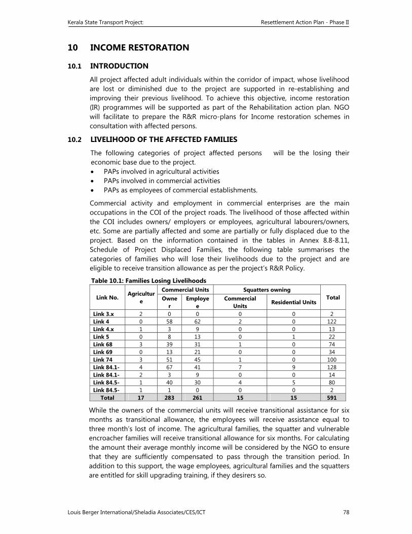
Kerala State Transport Project: Resettlement Action Plan - Phase II
Louis Berger International/Sheladia Associates/CES/ICT 78
10 INCOME RESTORATION
10.1 INTRODUCTION
All project affected adult individuals within the corridor of impact, whose livelihood are lost or diminished due to the project are supported in re-establishing and improving their previous livelihood. To achieve this objective, income restoration (IR) programmes will be supported as part of the Rehabilitation action plan. NGO will facilitate to prepare the R&R micro-plans for Income restoration schemes in consultation with affected persons.
10.2 LIVELIHOOD OF THE AFFECTED FAMILIES
The following categories of project affected persons will be the losing their economic base due to the project. • PAPs involved in agricultural activities • PAPs involved in commercial activities • PAPs as employees of commercial establishments.
Commercial activity and employment in commercial enterprises are the main occupations in the COI of the project roads. The livelihood of those affected within the COI includes owners/ employers or employees, agricultural labourers/owners, etc. Some are partially affected and some are partially or fully displaced due to the project. Based on the information contained in the tables in Annex 8.8-8.11, Schedule of Project Displaced Families, the following table summarises the categories of families who will lose their livelihoods due to the project and are eligible to receive transition allowance as per the project’s R&R Policy.
Table 10.1: Families Losing Livelihoods
Link No. Agriculture
Commercial Units Squatters owning Total Owne
r Employe
e Commercial
Units Residential Units
Link 3.x 2 0 0 0 0 2Link 4 0 58 62 2 0 122Link 4.x 1 3 9 0 0 13Link 5 0 8 13 0 1 22Link 68 3 39 31 1 0 74Link 69 0 13 21 0 0 34Link 74 3 51 45 1 0 100Link 84.1- 4 67 41 7 9 128Link 84.1- 2 3 9 0 0 14Link 84.5- 1 40 30 4 5 80Link 84.5- 1 1 0 0 0 2
Total 17 283 261 15 15 591
While the owners of the commercial units will receive transitional assistance for six months as transitional allowance, the employees will receive assistance equal to three month’s lost of income. The agricultural families, the squatter and vulnerable encroacher families will receive transitional allowance for six months. For calculating the amount their average monthly income will be considered by the NGO to ensure that they are sufficiently compensated to pass through the transition period. In addition to this support, the wage employees, agricultural families and the squatters are entitled for skill upgrading training, if they desirers so.
Kerala State Transport Project: Resettlement Action Plan - Phase II
Louis Berger International/Sheladia Associates/CES/ICT 79
Those belonging to the vulnerable category, whose livelihood is adversely affected due to the project, will be assisted to re-establish and improve their previous livelihood, providing Economic Rehabilitation Grant (ERG). This currently decided to be Rs. 24,000/-. This will help to enable them to stabilise or improve their earning capacity.
10.3 ACTIVITIES PROPOSED BY THE PAPS
The social impact surveys did not reveal any specific request or suggestion from the PAPs for income restoration activities. However, when asked what kind of assistance they would like to receive from the project authorities, people generally asked for assistance in the form of housing loans, bank loans, assistance under available government schemes, marketing facility, and cash assistance. When the implementation of RAP starts, more concrete responses can be expected.
As the majority of the project-affected people are educated there is a greater sense of self-reliance in their livelihood restructuring. However economically and socially vulnerable persons need to be supported sufficiently by providing economic rehabilitation grants /training for upgrading of skills/counselling etc .The micro-plans to be prepared by the NGOs will discuss in detail the appropriate measurers for income restoration of the concerned, arrived through the interaction with the affected person. The NGOs will also ensure that viable proposals are selected for such supports.
10.4 FAMILIES ELIGIBLE FOR VARIOUS ASSISTANCE
In addition to entitlements for the loss of land, structures and other assets to the project affected families as per the entitlement matrix of the KSTP R&R Policy, the RAP proposes to assist in income restoration and provide economic rehabilitation assistance to displaced residential families, wage employees, squatters, vulnerable encroachers, all other vulnerable families, agricultural families, and commercial families. The following income restoration measures and categories of eligible families are adopted by the KSTP R&R Policy:
A. Economic rehabilitation grant (#3147)
All vulnerable families including Title holders and Non titleholders Displaced wage employees
Displaced squatters
B. Transitional allowance (total 468 families) Titleholder PDF, residential structures (#137)
Titleholder PDF commercial structures (including res.-comm. mixed structures (#283)
Titleholder displaced agricultural families (#17)
Displaced squatters (#30) Displaced vulnerable encroachers( # 0)
C. Assistance for loss of wages Displaced wage employees (#261)
D. Training for skill upgrading (total 208 families) Displaced agricultural families (#17)
Displaced wage employees (#261) Displaced squatters (#30)
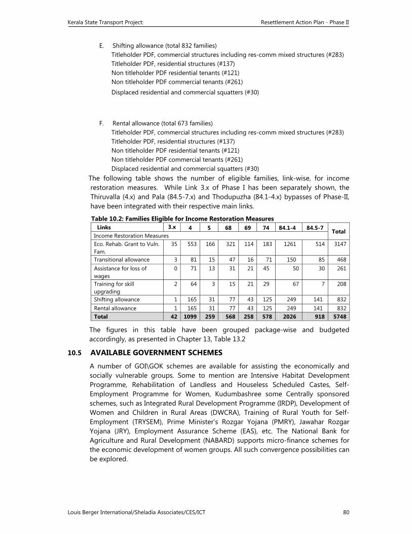
Kerala State Transport Project: Resettlement Action Plan - Phase II
Louis Berger International/Sheladia Associates/CES/ICT 80
E. Shifting allowance (total 832 families) Titleholder PDF, commercial structures including res-comm mixed structures (#283) Titleholder PDF, residential structures (#137) Non titleholder PDF residential tenants (#121) Non titleholder PDF commercial tenants (#261)
Displaced residential and commercial squatters (#30)
F. Rental allowance (total 673 families) Titleholder PDF, commercial structures including res-comm mixed structures (#283) Titleholder PDF, residential structures (#137) Non titleholder PDF residential tenants (#121) Non titleholder PDF commercial tenants (#261) Displaced residential and commercial squatters (#30)
The following table shows the number of eligible families, link-wise, for income restoration measures. While Link 3.x of Phase I has been separately shown, the Thiruvalla (4.x) and Pala (84.5-7.x) and Thodupuzha (84.1-4.x) bypasses of Phase-II, have been integrated with their respective main links.
Table 10.2: Families Eligible for Income Restoration Measures Links 3.x 4 5 68 69 74 84.1-4 84.5-7 Total Income Restoration Measures Eco. Rehab. Grant to Vuln. Fam.
35 553 166 321 114 183 1261 514 3147
Transitional allowance 3 81 15 47 16 71 150 85 468Assistance for loss of wages
0 71 13 31 21 45 50 30 261
Training for skill upgrading
2 64 3 15 21 29 67 7 208
Shifting allowance 1 165 31 77 43 125 249 141 832Rental allowance 1 165 31 77 43 125 249 141 832Total 42 1099 259 568 258 578 2026 918 5748
The figures in this table have been grouped package-wise and budgeted accordingly, as presented in Chapter 13, Table 13.2
10.5 AVAILABLE GOVERNMENT SCHEMES
A number of GOI\GOK schemes are available for assisting the economically and socially vulnerable groups. Some to mention are Intensive Habitat Development Programme, Rehabilitation of Landless and Houseless Scheduled Castes, Self-Employment Programme for Women, Kudumbashree some Centrally sponsored schemes, such as Integrated Rural Development Programme (IRDP), Development of Women and Children in Rural Areas (DWCRA), Training of Rural Youth for Self-Employment (TRYSEM), Prime Minister’s Rozgar Yojana (PMRY), Jawahar Rozgar Yojana (JRY), Employment Assurance Scheme (EAS), etc. The National Bank for Agriculture and Rural Development (NABARD) supports micro-finance schemes for the economic development of women groups. All such convergence possibilities can be explored.
Kerala State Transport Project: Resettlement Action Plan - Phase II
Louis Berger International/Sheladia Associates/CES/ICT 81
10.6 PREPARATION OF MICRO-PLANS
Micro plans will be prepared to support the affected families, based on the R&R policy. The eligibility of a person for support as per the R&R policy will be detailed in the micro plan on the basis of which Resettlement and Rehabilitation measurers are suggested. NGOs in charge of RAP implementation will prepare these micro plans in consultation with the affected parties. The details of the micro plan need to be submitted in the format.( refer Annex 6.2) along with detailed notes and supporting documents wherever necessary
The Titleholders in general are eligible for compensation for their property, structure and other immovable assets. Replacement value in addition to the Compensation for land and property as fixed by the District purchase Committee will be given as Special assistance. The Non titleholders such as tenants, employees, squatters, encroachers are eligible for special assistance as per the R&R policy. Vulnerable categories are protected through economic rehabilitation measurers. Ascertaining the eligibility for each affected person, The NGO will prepare a detailed micro plan. The process begins by Identification of the affected person and assessing his loss due to project; Analysing the problem and prioritising the needs; Selection of alternate choices for solutions; Preparation of most appropriate and cost effective solution; Skills training and capacity building;( if required) Preparation of specific project design; Identifying and mobilising additional resources Networking with financial and other institutions; Implementing the project; Monitoring and evaluation.
10.6.1 Income Generation Plan Outline
Introduction: the need and significance of the project Objectives Time bound activity schedule – a systematic analysis Organising and coordinating the activities Financial analysis – budget details and expected returns, repayment schedule (if
loan is availed of) Expected achievement Monitoring
10.7 INCOME RESTORATION ACTION PLAN
It is clear from the profile of the displaced wage employee and squatters that they are financially marginalized. The agricultural families being displaced too are small landholders. While the wage earners, mostly shop employees, and the squatters could be rehabilitated in their original livelihood, the agricultural families would need special attention for training in alternative livelihoods, if alternate agricultural land were not available for them. The NGOs engaged in the implementation of the RAP will, in consultation with these people, finalise appropriate livelihood skills
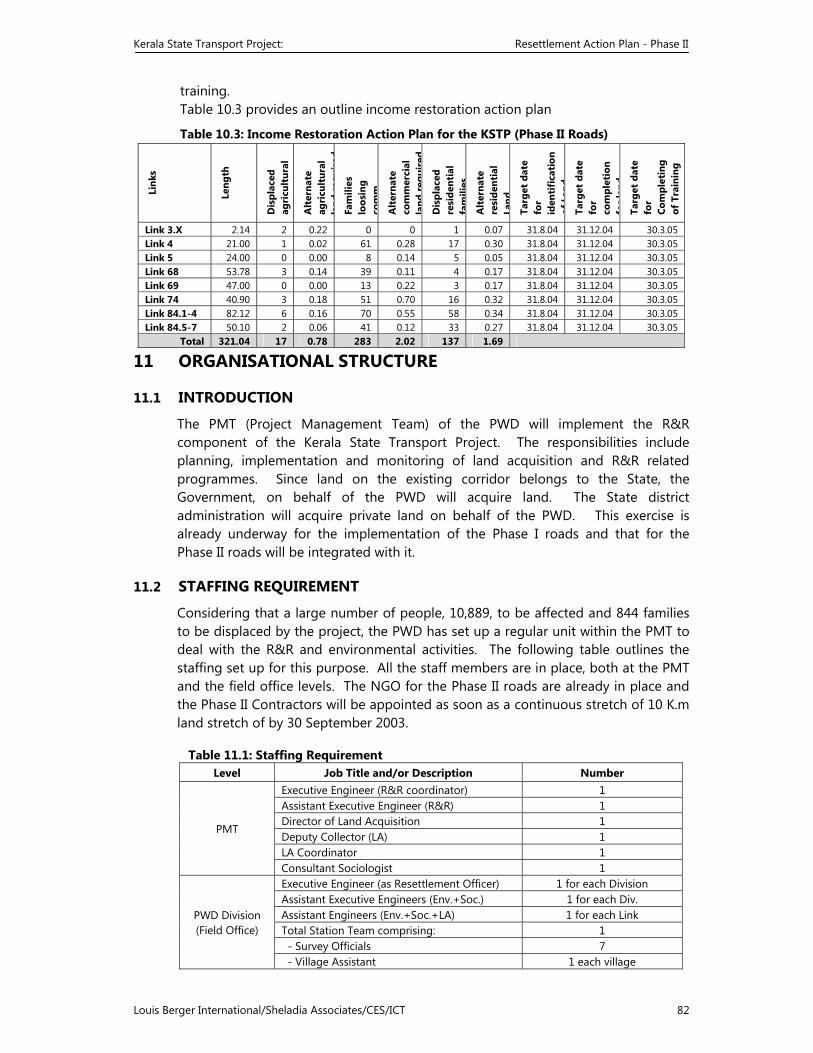
Kerala State Transport Project: Resettlement Action Plan - Phase II
Louis Berger International/Sheladia Associates/CES/ICT 82
training. Table 10.3 provides an outline income restoration action plan
Table 10.3: Income Restoration Action Plan for the KSTP (Phase II Roads)
11 ORGANISATIONAL STRUCTURE
11.1 INTRODUCTION
The PMT (Project Management Team) of the PWD will implement the R&R component of the Kerala State Transport Project. The responsibilities include planning, implementation and monitoring of land acquisition and R&R related programmes. Since land on the existing corridor belongs to the State, the Government, on behalf of the PWD will acquire land. The State district administration will acquire private land on behalf of the PWD. This exercise is already underway for the implementation of the Phase I roads and that for the Phase II roads will be integrated with it.
11.2 STAFFING REQUIREMENT
Considering that a large number of people, 10,889, to be affected and 844 families to be displaced by the project, the PWD has set up a regular unit within the PMT to deal with the R&R and environmental activities. The following table outlines the staffing set up for this purpose. All the staff members are in place, both at the PMT and the field office levels. The NGO for the Phase II roads are already in place and the Phase II Contractors will be appointed as soon as a continuous stretch of 10 K.m land stretch of by 30 September 2003.
Table 11.1: Staffing Requirement Level Job Title and/or Description Number
PMT
Executive Engineer (R&R coordinator) 1 Assistant Executive Engineer (R&R) 1 Director of Land Acquisition 1 Deputy Collector (LA) 1 LA Coordinator 1 Consultant Sociologist 1
PWD Division (Field Office)
Executive Engineer (as Resettlement Officer) 1 for each Division Assistant Executive Engineers (Env.+Soc.) 1 for each Div. Assistant Engineers (Env.+Soc.+LA) 1 for each Link Total Station Team comprising: 1 - Survey Officials 7 - Village Assistant 1 each village
Link
s
Leng
th
Dis
plac
ed
agri
cult
ural
Alt
erna
te
agri
cult
ural
la
ndre
quir
edFa
mili
es
loos
ing
com
m.
Alt
erna
te
com
mer
cial
la
ndre
quir
ed
Dis
plac
ed
resi
dent
ial
fam
ilies
Alt
erna
te
resi
dent
ial
Land
Targ
et d
ate
for
iden
tifi
cati
on
ofLa
ndTa
rget
dat
e fo
r co
mpl
etio
n fo
rla
ndTa
rget
dat
e fo
r Co
mpl
etin
g of
Tra
inin
g
Link 3.X 2.14 2 0.22 0 0 1 0.07 31.8.04 31.12.04 30.3.05 Link 4 21.00 1 0.02 61 0.28 17 0.30 31.8.04 31.12.04 30.3.05 Link 5 24.00 0 0.00 8 0.14 5 0.05 31.8.04 31.12.04 30.3.05 Link 68 53.78 3 0.14 39 0.11 4 0.17 31.8.04 31.12.04 30.3.05 Link 69 47.00 0 0.00 13 0.22 3 0.17 31.8.04 31.12.04 30.3.05 Link 74 40.90 3 0.18 51 0.70 16 0.32 31.8.04 31.12.04 30.3.05 Link 84.1-4 82.12 6 0.16 70 0.55 58 0.34 31.8.04 31.12.04 30.3.05 Link 84.5-7 50.10 2 0.06 41 0.12 33 0.27 31.8.04 31.12.04 30.3.05
Total 321.04 17 0.78 283 2.02 137 1.69
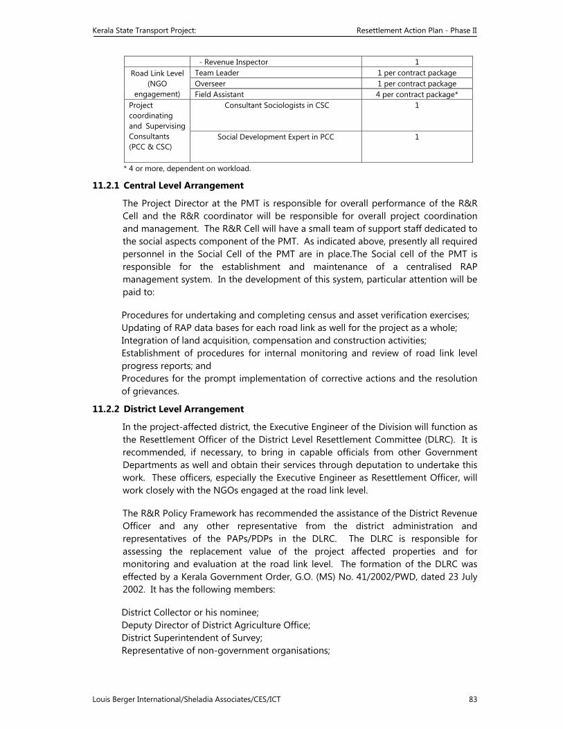
Kerala State Transport Project: Resettlement Action Plan - Phase II
Louis Berger International/Sheladia Associates/CES/ICT 83
- Revenue Inspector 1 Road Link Level
(NGO engagement)
Team Leader 1 per contract package Overseer 1 per contract package Field Assistant 4 per contract package*
Project coordinating and Supervising Consultants (PCC & CSC)
Consultant Sociologists in CSC 1
Social Development Expert in PCC 1
* 4 or more, dependent on workload.
11.2.1 Central Level Arrangement
The Project Director at the PMT is responsible for overall performance of the R&R Cell and the R&R coordinator will be responsible for overall project coordination and management. The R&R Cell will have a small team of support staff dedicated to the social aspects component of the PMT. As indicated above, presently all required personnel in the Social Cell of the PMT are in place.The Social cell of the PMT is responsible for the establishment and maintenance of a centralised RAP management system. In the development of this system, particular attention will be paid to:
Procedures for undertaking and completing census and asset verification exercises; Updating of RAP data bases for each road link as well for the project as a whole; Integration of land acquisition, compensation and construction activities; Establishment of procedures for internal monitoring and review of road link level progress reports; and Procedures for the prompt implementation of corrective actions and the resolution of grievances.
11.2.2 District Level Arrangement
In the project-affected district, the Executive Engineer of the Division will function as the Resettlement Officer of the District Level Resettlement Committee (DLRC). It is recommended, if necessary, to bring in capable officials from other Government Departments as well and obtain their services through deputation to undertake this work. These officers, especially the Executive Engineer as Resettlement Officer, will work closely with the NGOs engaged at the road link level.
The R&R Policy Framework has recommended the assistance of the District Revenue Officer and any other representative from the district administration and representatives of the PAPs/PDPs in the DLRC. The DLRC is responsible for assessing the replacement value of the project affected properties and for monitoring and evaluation at the road link level. The formation of the DLRC was effected by a Kerala Government Order, G.O. (MS) No. 41/2002/PWD, dated 23 July 2002. It has the following members:
District Collector or his nominee; Deputy Director of District Agriculture Office; District Superintendent of Survey; Representative of non-government organisations;
Kerala State Transport Project: Resettlement Action Plan - Phase II
Louis Berger International/Sheladia Associates/CES/ICT 84
Representatives of project affected persons. The District Level Resettlement Officer, i.e., Executive Engineer of the PWD KSTP Division, will nominate the representatives. Another Kerala Government Order, G.O. (Rt) No. 976/2002/PWD, dated 23 October 2002 has effected the constitution of a district level Citizen’s Advisory Committee (CAC) to ensure participation of people’s representatives and key Government officials in guiding and monitoring the contracted NGOs in the implementation of the RAP. The CAC has the following members:
District Collector - Chairman Executive Engineer, KSTP - Convenor MPs of the district - Members All MLAs of the district District Panchayat President Executive Engineer, Irrigation Executive Engineer, District Panchayat Division Three prominent citizens nominated by the DC
11.2.3 District level Resettlement and Grievance Redressal Committee
District level Resettlement and Grievance Redressal committees were constituted vide G.O.(MS) No. 41/2002/PWD dt. 237/2002 for setting the issues pertaining to Land Acquisition, rehabilitation and resettlement of the KSTP.
Kerala State Transport Project: Resettlement Action Plan - Phase II
Louis Berger International/Sheladia Associates/CES/ICT 85
The District level Resettlement Committee consists of the following members. 1. District Collector or his nominee 2. Asst. Agricultural officer 3. District Superintendent of Survey 4. Representative of the NGO 5. Representative of the PAP nominated by the Dist RRO
District level Grievance Redressal Committee will have the following members
1. District Collector (or his nominated representative) 2. Representative of the NGO 3. Panchayath President ( or nominated representative) 4. The District level Resettlement Officer, ie the Executive Engineer, KSTP will be
the convener of the committee. 5. Local MLA/MP/District panchayath President are invited to attend whenever
necessary. 6. The GRC will receive complaints/ petitions related to the project, obtain
factual reports on the matter, hear the aggrieved persons and effect Redressal of the grievances related to the perceived threats, inadequate compensation etc.
Project Level Arrangement - Divisional level arrangements are necessary for the coordination of the RAP activities, while the project level or road link level arrangements are most important for effective RAP implementation. The work of identifying and developing the resettlement sites for individuals or groups and other R&R related development activities would be undertaken by the NGOs engaged for the purpose. There will be an NGO contractor for each contract package. The NGOs will work in coordination with the Divisional Executive Engineer.
The NGO contractor will appoint a team leader, supported by one Overseer and at least four Field Assistants, for each NGO contract package, comprising one or more contiguous road links. This number, however, will vary according to the length of a given contract package. Each of these contract package R&R teams will be advised by the DLRC discussed above. The overall functions of the project level R&R team are:
• To establish and maintain consultation mechanisms with the supervising Resettlement Officer;
• To integrate land acquisition, compensation and construction activities; • To establish proper PAP data bases for the road links under its control; • To establish and maintain effective consultation mechanisms with the affected
families and communities; • To regularly liaise with the DLRC regarding the list of entitled persons, eviction
notices, compensation payments and grievance redress; • To regularly liaise with the District Revenue Officer to ensure prompt transfer of
affected land titles to the Revenue Department; and • To ensure implementation of resettlement and rehabilitation and support
measures as detailed in the entitlement policy.
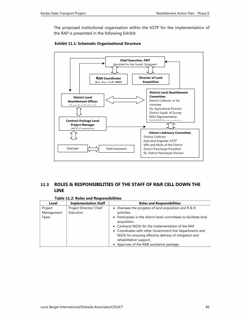
Kerala State Transport Project: Resettlement Action Plan - Phase II
Louis Berger International/Sheladia Associates/CES/ICT 86
The proposed institutional organization within the KSTP for the implementation of the RAP is presented in the following Exhibit: Exhibit 11.1: Schematic Organisational Structure
11.3 ROLES & RESPONSIBILITIES OF THE STAFF OF R&R CELL DOWN THE LINE Table 11.2: Roles and Responsibilities
Level Implementation Staff Roles and Responsibilities Project Management Team
Project Director/ Chief Executive
• Oversees the progress of land acquisition and R & R activities.
• Participates in the district level committees to facilitate land acquisition.
• Contracts NGOs for the implementation of the RAP. • Coordinates with other Government line Departments and
NGOs for ensuring effective delivery of mitigation and rehabilitation support.
• Approves of the R&R assistance package.
Chief Executive, PMT (Assisted by the Supdt. Engineer)
R&R Coordinator Env-Soc Cell PMT
District Level Resettlement Officer (Executive Engineer)
District Level Resettlement Committee District Collector or his nominee Dy. Agricultural Director District Supdt. of Survey NGO Representative PAP/PDP RepresentativeContract Package Level
Project Manager (NGO Contractor)
Director of Land Acquisition
Overseer Field Assistants
Citizen’s Advisory Committee District Collector Executive Engineer, KSTP MPs and MLAs of the District District Panchayat President EE, District Panchayat Division Th P i t Citi
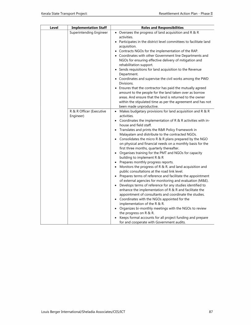
Kerala State Transport Project: Resettlement Action Plan - Phase II
Louis Berger International/Sheladia Associates/CES/ICT 87
Level Implementation Staff Roles and Responsibilities Superintending Engineer • Oversees the progress of land acquisition and R & R
activities. • Participates in the district level committees to facilitate land
acquisition. • Contracts NGOs for the implementation of the RAP. • Coordinates with other Government line Departments and
NGOs for ensuring effective delivery of mitigation and rehabilitation support.
• Sends requisitions for land acquisition to the Revenue Department.
• Coordinates and supervise the civil works among the PWD Divisions.
• Ensures that the contractor has paid the mutually agreed amount to the people for the land taken over as borrow areas. And ensure that the land is returned to the owner within the stipulated time as per the agreement and has not been made unproductive.
R & R Officer (Executive Engineer)
• Makes budgetary provisions for land acquisition and R & R activities.
• Coordinates the implementation of R & R activities with in-house and field staff.
• Translates and prints the R&R Policy Framework in Malayalam and distribute to the contracted NGOs.
• Consolidates the micro R & R plans prepared by the NGO on physical and financial needs on a monthly basis for the first three months, quarterly thereafter.
• Organises training for the PMT and NGOs for capacity building to implement R & R
• Prepares monthly progress reports. • Monitors the progress of R & R. and land acquisition and
public consultations at the road link level. • Prepares terms of reference and facilitate the appointment
of external agencies for monitoring and evaluation (M&E). • Develops terms of reference for any studies identified to
enhance the implementation of R & R and facilitate the appointment of consultants and coordinate the studies.
• Coordinates with the NGOs appointed for the implementation of the R & R.
• Organizes bi-monthly meetings with the NGOs to review the progress on R & R.
• Keeps formal accounts for all project funding and prepare for and cooperate with Government audits.
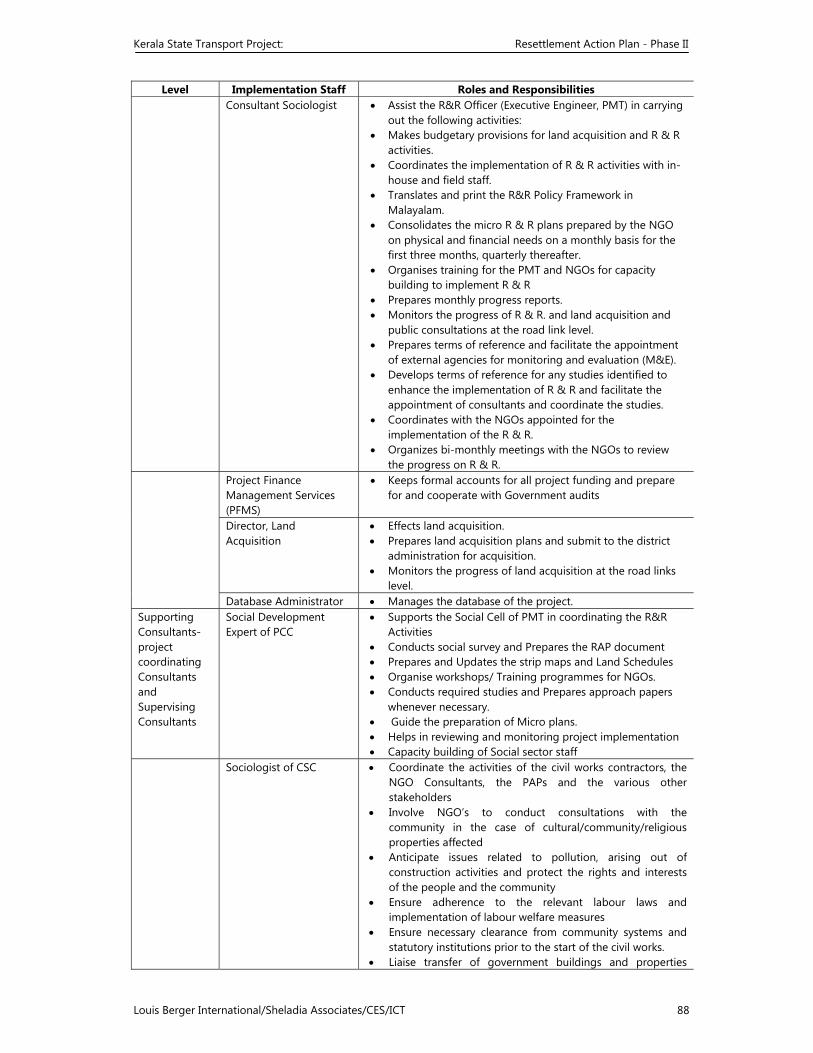
Kerala State Transport Project: Resettlement Action Plan - Phase II
Louis Berger International/Sheladia Associates/CES/ICT 88
Level Implementation Staff Roles and Responsibilities Consultant Sociologist • Assist the R&R Officer (Executive Engineer, PMT) in carrying
out the following activities: • Makes budgetary provisions for land acquisition and R & R
activities. • Coordinates the implementation of R & R activities with in-
house and field staff. • Translates and print the R&R Policy Framework in
Malayalam. • Consolidates the micro R & R plans prepared by the NGO
on physical and financial needs on a monthly basis for the first three months, quarterly thereafter.
• Organises training for the PMT and NGOs for capacity building to implement R & R
• Prepares monthly progress reports. • Monitors the progress of R & R. and land acquisition and
public consultations at the road link level. • Prepares terms of reference and facilitate the appointment
of external agencies for monitoring and evaluation (M&E). • Develops terms of reference for any studies identified to
enhance the implementation of R & R and facilitate the appointment of consultants and coordinate the studies.
• Coordinates with the NGOs appointed for the implementation of the R & R.
• Organizes bi-monthly meetings with the NGOs to review the progress on R & R.
Project Finance Management Services (PFMS)
• Keeps formal accounts for all project funding and prepare for and cooperate with Government audits
Director, Land Acquisition
• Effects land acquisition.• Prepares land acquisition plans and submit to the district
administration for acquisition. • Monitors the progress of land acquisition at the road links
level. Database Administrator • Manages the database of the project.
Supporting Consultants- project coordinating Consultants and Supervising Consultants
Social Development Expert of PCC
• Supports the Social Cell of PMT in coordinating the R&R Activities
• Conducts social survey and Prepares the RAP document • Prepares and Updates the strip maps and Land Schedules • Organise workshops/ Training programmes for NGOs. • Conducts required studies and Prepares approach papers
whenever necessary. • Guide the preparation of Micro plans. • Helps in reviewing and monitoring project implementation • Capacity building of Social sector staff
Sociologist of CSC • Coordinate the activities of the civil works contractors, the NGO Consultants, the PAPs and the various other stakeholders
• Involve NGO’s to conduct consultations with the community in the case of cultural/community/religious properties affected
• Anticipate issues related to pollution, arising out of construction activities and protect the rights and interests of the people and the community
• Ensure adherence to the relevant labour laws and implementation of labour welfare measures
• Ensure necessary clearance from community systems and statutory institutions prior to the start of the civil works.
• Liaise transfer of government buildings and properties
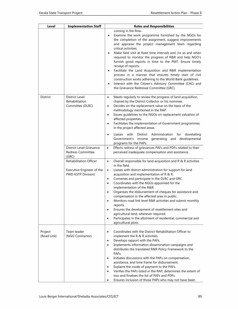
Kerala State Transport Project: Resettlement Action Plan - Phase II
Louis Berger International/Sheladia Associates/CES/ICT 89
Level Implementation Staff Roles and Responsibilities coming in the Row.
• Examine the work programme furnished by the NGOs for the completion of the assignment, suggest improvements and appraise the project management team regarding critical activities.
• Make field visit at fixed time intervals and /or as and when required to monitor the progress of R&R and help NGO’s furnish good reports in time to the PMT. Ensure timely receipt of reports.
• Facilitate the Land Acquisition and R&R implementation process in a manner that ensures timely start of civil construction works adhering to the World Bank guidelines.
• Interact with the Citizen’s Advisory Committee (CAC) and the Grievance Redressal Committee (GRC).
District
District Level Rehabilitation Committee (DLRC)
• Meets regularly to review the progress of land acquisition, chaired by the District Collector or his nominee.
• Decides on the replacement value on the basis of the methodology mentioned in the RAP.
• Issues guidelines to the NGOs on replacement valuation of affected properties.
• Facilitates the implementation of Government programmes in the project affected areas.
• Liaises with District Administration for dovetailing Government’s income generating and developmental programs for the PAPs.
District Level Grievance Redress Committee (GRC)
• Effects redress of grievances PAFs and PDFs related to their perceived inadequate compensation and assistance.
Rehabilitation Officer Executive Engineer of the PWD KSTP Division)
• Overall responsible for land acquisition and R & R activities in the field.
• Liaises with district administration for support for land acquisition and implementation of R & R.
• Convenes and participate in the DLRC and GRC. • Coordinates with the NGOs appointed for the
implementation of the R&R. • Organises the disbursement of cheques for assistance and
compensation in the affected area in public. • Monitors road link level R&R activities and submit monthly
reports. • Ensures the development of resettlement sites and
agricultural land, wherever required. • Participates in the allotment of residential, commercial and
agricultural plots. Project (Road Link)
Team leader (NGO Contractor)
• Coordinates with the District Rehabilitation Officer to
implement the R & R activities. • Develops rapport with the PAFs. • Implements information dissemination campaigns and
distributes the translated R&R Policy Framework to the PAFs.
• Initiates discussions with the PAFs on compensation, assistance, and time frame for disbursement.
• Explains the mode of payment to the PAFs. • Verifies the PAFs listed in the RAP, determines the extent of
loss and finalises the list of PAFs and PDFs. • Ensures inclusion of those PAPs who may not have been
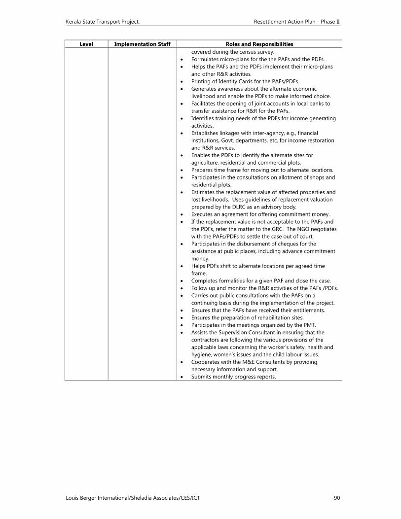
Kerala State Transport Project: Resettlement Action Plan - Phase II
Louis Berger International/Sheladia Associates/CES/ICT 90
Level Implementation Staff Roles and Responsibilities covered during the census survey.
• Formulates micro-plans for the the PAFs and the PDFs. • Helps the PAFs and the PDFs implement their micro-plans
and other R&R activities. • Printing of Identity Cards for the PAFs/PDFs. • Generates awareness about the alternate economic
livelihood and enable the PDFs to make informed choice. • Facilitates the opening of joint accounts in local banks to
transfer assistance for R&R for the PAFs. • Identifies training needs of the PDFs for income generating
activities. • Establishes linkages with inter-agency, e.g., financial
institutions, Govt. departments, etc. for income restoration and R&R services.
• Enables the PDFs to identify the alternate sites for agriculture, residential and commercial plots.
• Prepares time frame for moving out to alternate locations. • Participates in the consultations on allotment of shops and
residential plots. • Estimates the replacement value of affected properties and
lost livelihoods. Uses guidelines of replacement valuation prepared by the DLRC as an advisory body.
• Executes an agreement for offering commitment money. • If the replacement value is not acceptable to the PAFs and
the PDFs, refer the matter to the GRC. The NGO negotiates with the PAFs/PDFs to settle the case out of court.
• Participates in the disbursement of cheques for the assistance at public places, including advance commitment money.
• Helps PDFs shift to alternate locations per agreed time frame.
• Completes formalities for a given PAF and close the case. • Follow up and monitor the R&R activities of the PAFs /PDFs. • Carries out public consultations with the PAFs on a
continuing basis during the implementation of the project. • Ensures that the PAFs have received their entitlements. • Ensures the preparation of rehabilitation sites. • Participates in the meetings organized by the PMT. • Assists the Supervision Consultant in ensuring that the
contractors are following the various provisions of the applicable laws concerning the worker’s safety, health and hygiene, women’s issues and the child labour issues.
• Cooperates with the M&E Consultants by providing necessary information and support.
• Submits monthly progress reports.
Kerala State Transport Project: Resettlement Action Plan - Phase II
Louis Berger International/Sheladia Associates/CES/ICT 91
12 CAPACITY BUILDING
12.1 INTRODUCTION
Capacity building of the key functionaries and primary stakeholders to successfully implement the project as envisaged, is the key to the success of any development project. Public Works Department is the chief implementing agency for the KSTP. Since it’s inception, PWD personnel are pioneers in the road sector and have built the roads in the State. But Kerala State Transport project has a different philosophy and approach, which has to be familiarised by all concerned.. Therefore all key functionaries of the project are to be adequately capacitated to work efficiently in the changed situation. The programmes must be so structured to unearth and unleash their tremendous latent internal energies and creative potential to implement the project with its social, technical, financial dimensions.
Many Departments such as Land acquisition and Survey Department, Water resources Department, Various Consulting agencies and selected NGOs are playing equally important roles in the project All these functionaries need to work in tandem dividing the roles and responsibilities among them as envisaged. Capacity building of these team-mates is equally important.
SMEC, the Independent reviewers of RAP phase II (draft) and World Bank appraisal missions have highlighted the significance of capacity building through training, in various contexts. An exclusive chapter on Capacity building is added to RAP considering its significance.
12.2 PRIME STAKEHOLDERS AT THREE LEVELS
As in any other development project, the stakeholders require knowledge, skills and management practices in the spheres of technical, institutional, financial and management aspects of the project. In KSTP, the prime stakeholders includes Project management team at the top level supported by various Consultant Agencies, District level team of officers, Land Acquisition officers, IWT officers from the Water Resources Department, NGOs, Construction Contractors, Lateral Departments, Members of the District Resettlement committees/Advisor committee, Valuers, Local self govt representatives, and Project Affected persons. Table () will give the details of the stakeholders. Considering the functional levels, Training in homogenous groups will be ideal to promote interactive sessions as well as to cover classes of similar wavelengths, but in divisional areas mixing functionally operational groups as per convenience can be considered.
12.3 EXTEND AND NATURE OF CAPACITY BUILDING
Apex /strategic level - Regardless of the skill development level of the functionaries, the policy level actors of the project, including key functionaries of the PMT & Senior Divisional office staff need orientation to the approach and system for accessing and working with project resources. Intermediary level - The multi disciplinary teams of the NGOs, divisional level asst engineers, engineers of contractors, supervision consultants etc can fall in this category. Engineers dealing with the R&R implementation need to be thoroughly oriented on social aspects of the project and project management and coordination.
Kerala State Transport Project: Resettlement Action Plan - Phase II
Louis Berger International/Sheladia Associates/CES/ICT 92
Similarly NGOs engaged for RAP implementation requires sufficient skill development to deliver their responsibilities. In Kerala, at present no NGO has adequate skill to support a transport project as envisaged and those recruited need to be equipped through training and capacity building. The environmental and social orientation to the contractor staff and supervising consultants are other vital sectors. Being an A grade World Bank project many studies were conducted on environmental social issues and unless these are shred with the implementing agencies, they will remain in paper only. Grass root level stakeholders are the PAPs and elected representatives. Who needs mostly information dissemination through IEC methods. They need to be oriented to the philosophy, salient features and components of the project, resettlement and rehabilitation policies for the PAPs, Land acquisition act procedures, Grievance Redressal processes, Environmental and Social management issues which needs area specific attention and support, conditions payment of compensations to PAPs, Maintenance and road safety aspects. This is the function of the NGO, through Public Consultations/meetings.
12.3.1 Skill building/ Skill upgradation of the vulnerable PAPs
Skill building training will be organised to vulnerable PAPs/PDPs as per their choice, which will be locally arranged by the concerned NGO, through identified training agencies .The vulnerable PAPs are expected to acquire better skills to earn more income and achieve better livelihood, through this.
12.4 COORDINATION OF THE CAPACITY BUILDING PROGRAMMES.
The Social Cell of PMT can play the role of Apex Coordination Agency coordinating the training programmes entrusted with various Consulting Agencies, considering their expertise. Since the Consultants and Experts are associating with the Project from the beginning, their expertise and experience can be utilised for coordinating the training programmes and provide inputs in their concerned area of specialisation. For smooth functioning of such a system, the roles and responsibilities of each agency, modus operandi, subject areas, fund flow, reporting and evaluation mechanism, convergence and coordination methods etc need to be clearly spelt out .The following table will explain the levels and roles for each consulting agency.
Table 12.1: Coordination agencies for capacity building
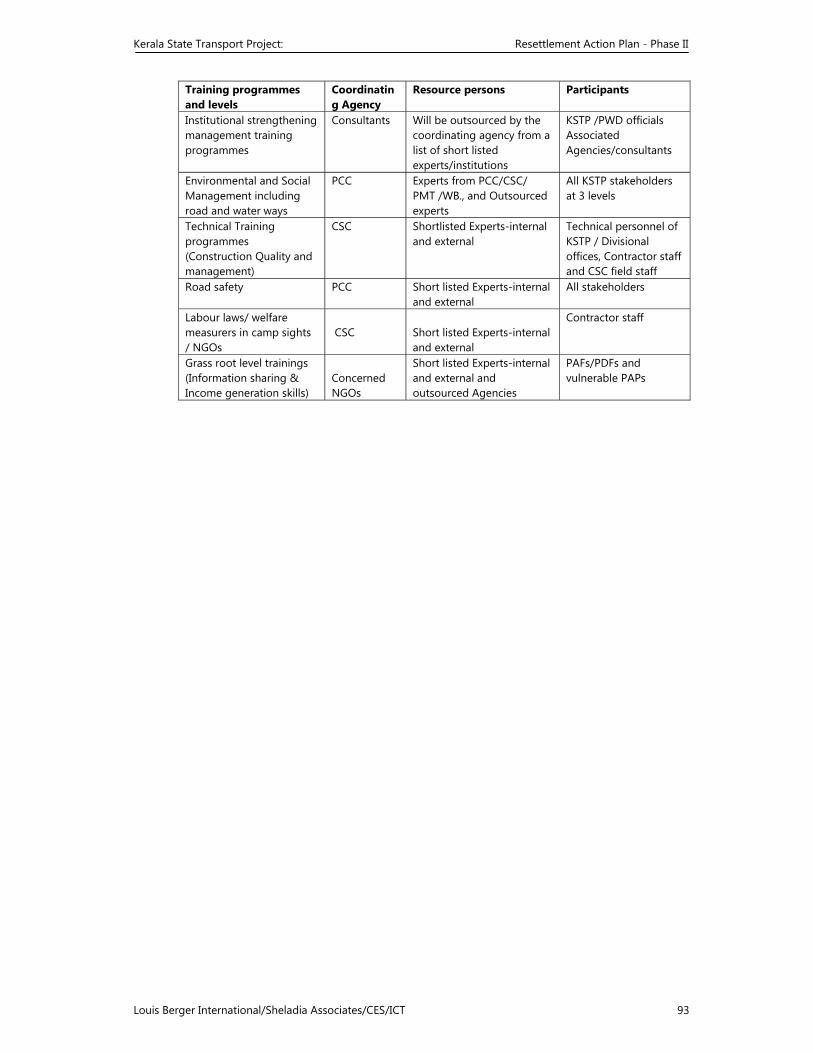
Kerala State Transport Project: Resettlement Action Plan - Phase II
Louis Berger International/Sheladia Associates/CES/ICT 93
Training programmes and levels
Coordinating Agency
Resource persons Participants
Institutional strengthening management training programmes
Consultants Will be outsourced by the coordinating agency from a list of short listed experts/institutions
KSTP /PWD officials Associated Agencies/consultants
Environmental and Social Management including road and water ways
PCC Experts from PCC/CSC/ PMT /WB., and Outsourced experts
All KSTP stakeholders at 3 levels
Technical Training programmes (Construction Quality and management)
CSC Shortlisted Experts-internal and external
Technical personnel of KSTP / Divisional offices, Contractor staff and CSC field staff
Road safety PCC Short listed Experts-internal and external
All stakeholders
Labour laws/ welfare measurers in camp sights / NGOs
CSC
Short listed Experts-internal and external
Contractor staff
Grass root level trainings (Information sharing & Income generation skills)
Concerned NGOs
Short listed Experts-internal and external and outsourced Agencies
PAFs/PDFs and vulnerable PAPs
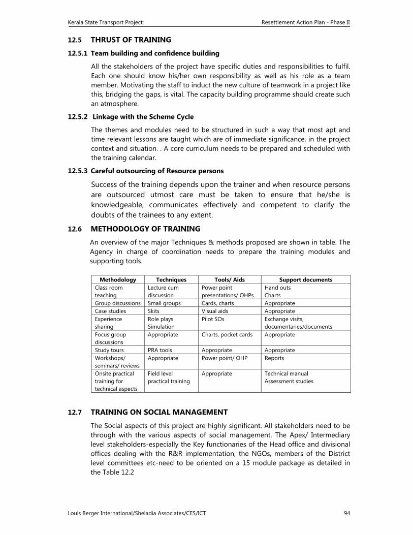
Kerala State Transport Project: Resettlement Action Plan - Phase II
Louis Berger International/Sheladia Associates/CES/ICT 94
12.5 THRUST OF TRAINING
12.5.1 Team building and confidence building
All the stakeholders of the project have specific duties and responsibilities to fulfil. Each one should know his/her own responsibility as well as his role as a team member. Motivating the staff to induct the new culture of teamwork in a project like this, bridging the gaps, is vital. The capacity building programme should create such an atmosphere.
12.5.2 Linkage with the Scheme Cycle
The themes and modules need to be structured in such a way that most apt and time relevant lessons are taught which are of immediate significance, in the project context and situation. . A core curriculum needs to be prepared and scheduled with the training calendar.
12.5.3 Careful outsourcing of Resource persons
Success of the training depends upon the trainer and when resource persons are outsourced utmost care must be taken to ensure that he/she is knowledgeable, communicates effectively and competent to clarify the doubts of the trainees to any extent.
12.6 METHODOLOGY OF TRAINING
An overview of the major Techniques & methods proposed are shown in table. The Agency in charge of coordination needs to prepare the training modules and supporting tools.
Methodology Techniques Tools/ Aids Support documents
Class room teaching
Lecture cum discussion
Power point presentations/ OHPs
Hand outs Charts
Group discussions Small groups Cards, charts Appropriate Case studies Skits Visual aids Appropriate Experience sharing
Role plays Simulation
Pilot SOs Exchange visits, documentaries/documents
Focus group discussions
Appropriate Charts, pocket cards Appropriate
Study tours PRA tools Appropriate Appropriate Workshops/ seminars/ reviews
Appropriate Power point/ OHP Reports
Onsite practical training for technical aspects
Field level practical training
Appropriate Technical manual Assessment studies
12.7 TRAINING ON SOCIAL MANAGEMENT
The Social aspects of this project are highly significant. All stakeholders need to be through with the various aspects of social management. The Apex/ Intermediary level stakeholders-especially the Key functionaries of the Head office and divisional offices dealing with the R&R implementation, the NGOs, members of the District level committees etc-need to be oriented on a 15 module package as detailed in the Table 12.2
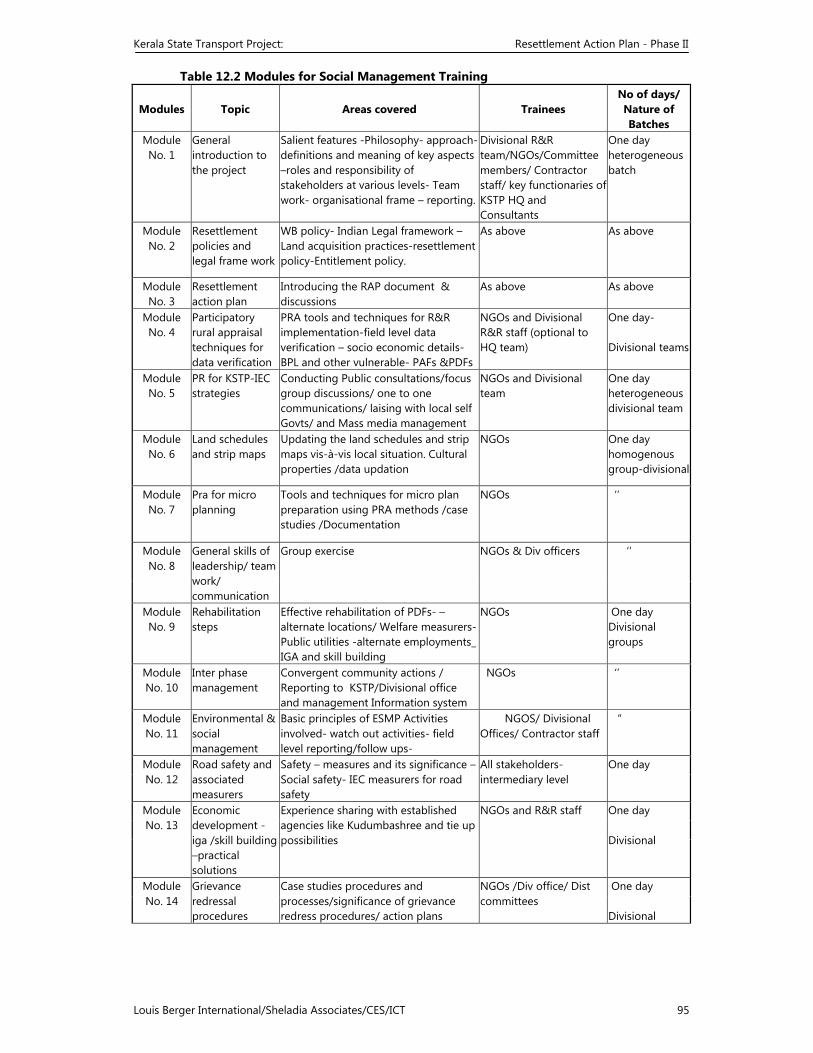
Kerala State Transport Project: Resettlement Action Plan - Phase II
Louis Berger International/Sheladia Associates/CES/ICT 95
Table 12.2 Modules for Social Management Training
Modules Topic Areas covered Trainees No of days/ Nature of Batches
Module No. 1
General introduction to the project
Salient features -Philosophy- approach-definitions and meaning of key aspects –roles and responsibility of stakeholders at various levels- Team work- organisational frame – reporting.
Divisional R&R team/NGOs/Committee members/ Contractor staff/ key functionaries of KSTP HQ and Consultants
One day heterogeneous batch
Module No. 2
Resettlement policies and legal frame work
WB policy- Indian Legal framework –Land acquisition practices-resettlement policy-Entitlement policy.
As above As above
Module No. 3
Resettlement action plan
Introducing the RAP document & discussions
As above As above
Module No. 4
Participatory rural appraisal techniques for data verification
PRA tools and techniques for R&R implementation-field level data verification – socio economic details- BPL and other vulnerable- PAFs &PDFs
NGOs and Divisional R&R staff (optional to HQ team)
One day- Divisional teams
Module No. 5
PR for KSTP-IEC strategies
Conducting Public consultations/focus group discussions/ one to one communications/ laising with local self Govts/ and Mass media management
NGOs and Divisional team
One day heterogeneous divisional team
Module No. 6
Land schedules and strip maps
Updating the land schedules and strip maps vis-à-vis local situation. Cultural properties /data updation
NGOs One day homogenous group-divisional
Module No. 7
Pra for micro planning
Tools and techniques for micro plan preparation using PRA methods /case studies /Documentation
NGOs ‘’
Module No. 8
General skills of leadership/ team work/ communication
Group exercise NGOs & Div officers ‘’
Module No. 9
Rehabilitation steps
Effective rehabilitation of PDFs- – alternate locations/ Welfare measurers-Public utilities -alternate employments_ IGA and skill building
NGOs One day Divisional groups
Module No. 10
Inter phase management
Convergent community actions / Reporting to KSTP/Divisional office and management Information system
NGOs ‘’
Module No. 11
Environmental & social management
Basic principles of ESMP Activities involved- watch out activities- field level reporting/follow ups-
NGOS/ Divisional Offices/ Contractor staff
“
Module No. 12
Road safety and associated measurers
Safety – measures and its significance –Social safety- IEC measurers for road safety
All stakeholders-intermediary level
One day
Module No. 13
Economic development -iga /skill building –practical solutions
Experience sharing with established agencies like Kudumbashree and tie up possibilities
NGOs and R&R staff One day Divisional
Module No. 14
Grievance redressal procedures
Case studies procedures and processes/significance of grievance redress procedures/ action plans
NGOs /Div office/ Dist committees
One day Divisional
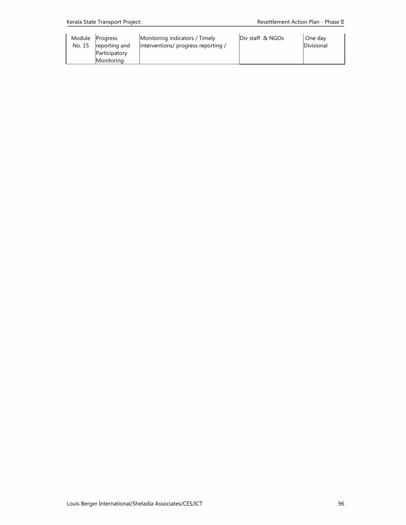
Kerala State Transport Project: Resettlement Action Plan - Phase II
Louis Berger International/Sheladia Associates/CES/ICT 96
Module No. 15
Progress reporting and Participatory Monitoring
Monitoring indicators / Timely interventions/ progress reporting /
Div staff & NGOs One day Divisional
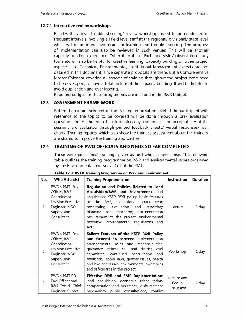
Kerala State Transport Project: Resettlement Action Plan - Phase II
Louis Berger International/Sheladia Associates/CES/ICT 97
12.7.1 Interactive review workshops
Besides the above, trouble shooting/ review workshops need to be conducted in frequent intervals involving all field level staff at the regional/ divisional/ state level, which will be an interactive forum for learning and trouble shooting. The progress of implementation can also be reviewed in such venues. This will be another capacity building experience. Other than these, Exchange visits/ observation study tours etc will also be helpful for creative learning. Capacity building on other project aspects - i.e. Technical, Environmental, Institutional Management aspects-are not detailed in this document, since separate proposals are there. But a Comprehensive Master Calendar covering all aspects of training throughout the project cycle need to be developed, to have a total picture of the capacity building. It will be helpful to avoid duplication and over lapping. Required budget for these programmes are included in the R&R budget.
12.8 ASSESSMENT FRAME WORK
Before the commencement of the training, information level of the participant with reference to the topics to be covered will be done through a pre- evaluation questionnaire. At the end of each training day, the impact and acceptability of the sessions are evaluated through printed feedback sheets/ verbal responses/ wall charts. Training reports, which also show the trainees assessment about the trainers, are shared to improve the training approaches.
12.9 TRAINING OF PWD OFFICIALS AND NGOS SO FAR COMPLETED
These were piece meal trainings given as and when a need arise. The following table outlines the training programme on R&R and environmental issues organised by the Environmental and Social Cell of the PMT:
Table 12.3: KSTP Training Programme on R&R and Environment
No. Who Attends? Training Programme on Instruction Duration
1
PWD’s PMT Env. Officer, R&R Coordinator, Division Executive Engineer, NGO, Supervision Consultant
Regulation and Policies Related to Land Acquisition/R&R and Environment: land acquisition; KSTP R&R policy; basic features of the RAP; institutional arrangement; monitoring, evaluation and reporting; planning for relocation; documentation requirement of the project; environmental overview; environmental regulations and Acts.
Lecture 1 day
2
PWD’s PMT Env. Officer, R&R Coordinator, Division Executive Engineer, NGO, Supervision Consultant
Salient Features of the KSTP R&R Policy and General EA aspects: implementation arrangements, roles and responsibilities, grievance redress cell and district level committee, continued consultation and feedback, labour laws, gender issues, health and hygiene issues, environmental awareness and safeguards in the project.
Workshop 1 day
3
PWD’s PMT PD, Env. Officer and R&R Coord., Chief Engineer, Suptdt.
Effective R&R and EMP Implementation: land acquisition, economic rehabilitation, compensation and assistance, disbursement mechanism, public consultations, conflict
Lecture and Group
Discussion 1 day
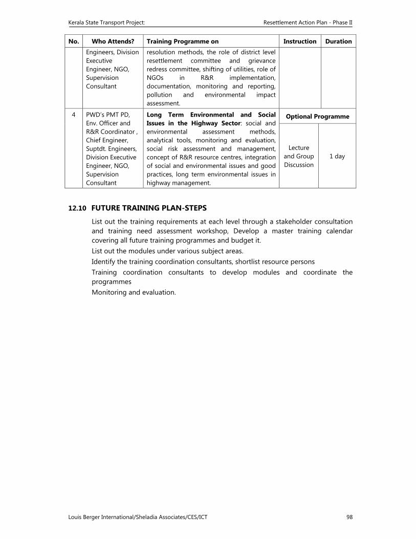
Kerala State Transport Project: Resettlement Action Plan - Phase II
Louis Berger International/Sheladia Associates/CES/ICT 98
No. Who Attends? Training Programme on Instruction Duration
Engineers, Division Executive Engineer, NGO, Supervision Consultant
resolution methods, the role of district level resettlement committee and grievance redress committee, shifting of utilities, role of NGOs in R&R implementation, documentation, monitoring and reporting, pollution and environmental impact assessment.
4 PWD’s PMT PD, Env. Officer and R&R Coordinator , Chief Engineer, Suptdt. Engineers, Division Executive Engineer, NGO, Supervision Consultant
Long Term Environmental and Social Issues in the Highway Sector: social and environmental assessment methods, analytical tools, monitoring and evaluation, social risk assessment and management, concept of R&R resource centres, integration of social and environmental issues and good practices, long term environmental issues in highway management.
Optional Programme
Lecture and Group Discussion
1 day
12.10 FUTURE TRAINING PLAN-STEPS
List out the training requirements at each level through a stakeholder consultation and training need assessment workshop, Develop a master training calendar covering all future training programmes and budget it. List out the modules under various subject areas. Identify the training coordination consultants, shortlist resource persons Training coordination consultants to develop modules and coordinate the programmes Monitoring and evaluation.
Kerala State Transport Project: Resettlement Action Plan - Phase II
Louis Berger International/Sheladia Associates/CES/ICT 99
13 IMPLEMENTATION SCHEDULE
13.1 INTRODUCTION
The implementation of the RAP will consist of land acquisition and R & R activities. The programme schedule for the remaining major tasks of the RAP is shown in Table 12-1. This schedule will be updated as the project progresses. The NGO contract package level R&R Project Managers will prepare a simplified summary on the operational aspect of the implementation plan. The R&R activities of the whole project will be completed in approximately 36 months time, with some activities stretching out longer. If there are unforeseen problems, land acquisition will take longer. Three links of the Phase II roads will require environmental clearance and the process of obtaining the clearance has already been initiated. The land acquisition activity for the Phase II roads is expected to be complete by November 2004 and construction is expected to commence from 15 December 2004. The payments of compensation vide the micro plan will be effected before the construction works starts. As the land acquisition and the R&R activities for the Phase I roads are already underway, the implementation schedule as presented in Table 12-1 is integrated with and continues from the one prepared for the Phase I roads.
13.2 THE IMPLEMENTATION PROCEDURE
The implementation of the RAP consists of following major stages:
A. Deployment and training of staff; B. Issuing of legal notification for land acquisition and the cut-off date; C. Verification and Social Survey of affected and displaced properties, cultural
and community properties. D. Land acquisition process E. Preparation of Micro plans for Non titleholders/titleholders/ vulnerable
PAPs. F. Verification of Micro plans and modifications. G. Arranging training for the identified PAPs H. Resettlement arrangements for the displaced.-residential/commercial units. I. Construction of structures- cultural/ community and rehabilitation units. J. Preparation of list of EPs for relocation; K. Identify the Relocation of sites for displaced EPs L. Public consultations to resolve issues M. Approval of micro plans, completion of LA process and payment effected N. Opening of Bank Accounts and issue of identity cards to the EPs. O. Economic rehabilitation of vulnerable EPs. P. Relocation and rehabilitation of EPs Q. Monitoring and evaluation.
The R&R activities commence with the deployment of staff for Land acquisition, and Land acquisition processes are initiated through issuing the notification for Land
Kerala State Transport Project: Resettlement Action Plan - Phase II
Louis Berger International/Sheladia Associates/CES/ICT 100
Acquisition. The NGO team responsible for the implementation of RAP vide the R&R policy will given charge of the respective links and directed to open offices in the respective locations. The Staff of the NGO and Divisional R&R team are trained and equipped to commence the activities. But this training will be an ongoing programme as detailed in the training calendar. The NGO starts the fieldwork with the verification of the data, through social survey. A specific format developed for this purpose is attached in the Annexure-V. The survey will be completed village wise and consolidate accordingly. The NGO will organise Public Consultations to educate the Public about the Project simultaneously. Wherever required they will sought the support of authorities to conduct such Consultation meetings.
13.3 THE BASIS OF IMPLEMENTATION
The basis of RAP implementation is the PAP database developed and installed in all NGO computers The list of affected EPs and assets needs to be verified prior to construction/upgrading works and adjustments made to the PAP database. There is a likelihood of the number of EPs increasing or decreasing. Increasing – by way of persons turning 18 or a shopkeeper hiring new employees on the date of the particular land acquisition. Decreasing – by way of death of an EP, or a shop employee leaving an affected establishment before land acquisition. For the acquisition of land from Cultural (Religious institutions) and Community Properties, special efforts need to be taken. Consultations with Committees at the different levels and documenting the same are significant. Appropriate rehabilitation plan for these centres are to be developed with the support of supervising consultants. Preparation of micro plans for the Non titleholders, vulnerable class etc can be initiated well in advance by the NGO to facilitate their resettlement and rehabilitation in accordance with the R&R policy. When the LA process is complete micro plans for the Titleholders can be completed. Both these as well as the rehabilitation of cultural and community properties need to converge to facilitate the release of land for construction works, within the stipulated project time. Verification of the draft micro plans prepared for the Non-titleholders (village wise) can be done with the support of designated coordinators, who will be designated by the PMT, to provide focused support to each road package. Documents cleared by them can be forwarded to the Divisional RRO, Sociologist of the Supervising Consultants. Sociologist of the CSC will scrutinise the micro plans as well as cross check the field realities and recommend the same to the RRO for onward transmission to the PMT for final approval. At the PMT, the Consultant Sociologist will verify the proposals for compliance to the R&R policy prepare a detailed note to that effect and submit to the Chief Executive for approval. Chief Executive approves the micro plan and authorise the Divisional RRO to release the amount as detailed in the financial procedure issued for the purpose. Payment of Compensations will be given through two channels to the Titleholders. LA compensation will be issued through Treasury checks only, while additional compensations and other assistance vide the micro plans will be given through bank accounts, operated jointly by the EP, NGO and RRO. . For Non- titleholders direct checks will be issued for payments below Rs 10000/- and payment through joint accounts in Banks, as recommended by the NGO, considering the progress of implementation. Ngo will ensure that the micro plans are implemented as envisaged in the plan.
Kerala State Transport Project: Resettlement Action Plan - Phase II
Louis Berger International/Sheladia Associates/CES/ICT 101
For Phase 2 projects, focussed action to release 10 K.m continuous stretches of land to facilitate road construction works by the Contractors in time, is recommended by the World Bank. NGO need to initiate concerted action to achieve this.
Kerala State Transport Project: Resettlement Action Plan - Phase II
Louis Berger International/Sheladia Associates/CES/ICT 102
13.4 GENERAL ACTIVITIES
• Appointment of staff at the PIU; In place
• Contracting NGOs; Joined on 13/11/ 2003
• District level committees set-up by the State Government; (Completed)
• Training of the R&R managers and NGOs for the implementation of the RAP;
Training on two modules completed.
• Translation and printing of R&R policy in local language. Preparing pamphlets of R&R policy in local language;
(Completed)
• Distributing the R&R policy to the EPs; NGOs will distribute during the survey
• Verification of the EPs; Commence from 15/12/2003
• Updating the census data base to include those who may have been left out during the census survey;
Ongoing. Expected to be complete by end February 2004
• Distribution of Identity Cards; Photos will be taken before 2/2004. card will be issued by October 2004
• Opening of joint accounts in the name of EP, representative of NGOs and the contract level R&R officer;
November 2004
• Public consultations and creating awareness about the project amongst the PAPs;
From 15/12/03 onwards- as a continuous activity
• Monitor physical and financial progress; Monthly and quarterly reviews
• Prepare monthly progress reports. December 03 onwards – Vt working day of following month
13.5 LAND ACQUISITION
(Priority stretches–village wise continuous stretch of 10 km) A. Land will be permanently and temporarily affected by the project
• Permanent acquisition will be under the Land Acquisition Act 1894 (amended in 1984) and will comprise the following activities:
• Preparing land plans and land schedules for acquisition with details about the total holding and the area affected;
(Completed)
• Appointment of the competent authority; Will be over by end December 2003
• Issue of notices as per the Land Acquisition Act for acquisition;
• Joint verification by PWD and survey staff • Section 6; Survey and boundaries act. 6.1,LA Act (issue of
DD)
End January 2004 End January 2004 End May 2004
• Announcement of compensation award as per the Act; September 2004 • Issue of cheques in public places prior to taking
possession; November 2004
B. Temporarily affected land will facilitate civil works on the project roads by providing diversion routes for traffic and for earth works from borrow areas: • Contractor negotiates with owners the area to be leased; November 2004 • The contract signed between the owner and the contractor
Kerala State Transport Project: Resettlement Action Plan - Phase II
Louis Berger International/Sheladia Associates/CES/ICT 103
will include the terms of payment and return of the land to the owner;
November 2004
• Complete payments will be made to the Contractor after the PIU is satisfied that the terms and conditions of the contract have been met;
November 2004
• Returning the land after restoring to its original condition.
On completion of the works
13.6 RESETTLEMENT
Civil works will begin after people have been relocated. The following activities are included:
• Verification of the displaced population – agriculture, residential and commercial;
End February 2004
• Identification of alternate plots in consultation with the people;
• Preparation of draft micro plans for Non titleholders( Priority stretch)
• Resettlement of NTH
August 2004
End February 2004 onwards
November 2004 onwards
• Development of the relocation sites with basic infrastructure facilities;
August 2004
• Disbursement of shifting allowance and rental allowance; October 2004
• Setting up of temporary sites if needed; November 2004
• Announcement and disbursement of the replacement value of the property affected of EPs and payment through cheques in public places;
November 2004
• Allotment of plots to EPs through public consultations; November 2004
• Construction of residence and shops at the resettlement sites by the PAPs or the PMT as desired by the PAPs;
November 2004 onwards
• Developing shopping complexes wherever required; November 2004 onwards
• Building/relocating the community facilities in consultation with the community;
November 2004 onwards
13.7 REHABILITATION
• Verification of EPs entitled to transitional allowance, alternative
economic rehabilitation support and economic rehabilitation grant;
End March 2004
• Providing information to EPs to make informed choice about income generation (IG) programme;
End March 2004
• Training for upgrading of skills for IG programme; July- August 2004 • Payment of assistance to synchronize with the release of
compensation paid to EPs; October 2004
• Income generating activity for each EP to be planned by the EPs in consultation with the NGOs.
December 2004
Kerala State Transport Project: Resettlement Action Plan - Phase II
Louis Berger International/Sheladia Associates/CES/ICT 104
Kerala State Transport Project: Resettlement Action Plan - Phase II
Louis Berger International/Sheladia Associates/CES/ICT 105
14 COSTS AND BUDGET
14.1 INTRODUCTION
The budget is indicative with outlays for the different expenditure categories calculated at the 1999 price index. The information on costs was collected by the socio-economic and census surveys of the PAPs together with field inquiries conducted by the Project Quantity Surveyor. Land compensation cost has been calculated on the basis of the best available Government registered market prices and the building replacement cost has been calculated on the basis of the PWD’s Basic Schedule of Rates (BSR). The information reported here is based on discussions with the Government officials responsible for land acquisition. No certified copies of Government registered land prices are available.
14.2 METHODOLOGY FOR THE VALUATION OF COSTS
14.2.1 Valuation of Land Cost
The private lands to be acquired along the project roads have been estimated on the basis of the land schedules (Annex 8.2-8.6 and Annex 8.8-8.11). The compensation of land has the addition of 30% solatium, 12% additional and 12% interest on the Government registered market price. In the case of agricultural land, in addition, there is a 10% severance grant according to the KSTP R&R Principles and Policy. It was noticed during the social surveys and the market survey of the replacement value of land that there is a difference of 40% in average cost of one sq.m. of agricultural land between the Government registered market price and current replacement value, 120% difference between Government registered price and current replacement cost of residential land, and 125% difference between Government registered price and current market price of commercial land. The replacement cost of land varies from link to link, and within a link the price of residential land is different from that of commercial or agricultural land. Commercial area land is further divided into town centres and other areas with shops. The land cost is more in the town centres than for lands in commercial use in other areas. An average estimate for different use of lands has been made and illustrated below:
Unit cost of agricultural land per m2 Rs. 285 Unit cost of homestead land per m2 Rs. 485 Unit cost of commercial land per m2 Rs. 895 Unit cost of “other” use land per m2 Rs. 430 Unit cost of rubber plantation land per ha Rs. 1,490,000 Unit cost of pineapple plantation land per ha Rs. 740,000
14.2.2 Valuation of Replacement Cost of Structures
The valuation of assets replacement has been based on the PWD’s Basic Schedule of Rates (without depreciation), which provides the unit costs of construction materials. An average estimate has been calculated for the following items:
Kerala State Transport Project: Resettlement Action Plan - Phase II
Louis Berger International/Sheladia Associates/CES/ICT 106
Unit cost of a pucca structure per m2 Rs. 3000 Unit cost of a kutcha structure per m2 Rs. 1000 Unit cost of a bunk per m2 Rs. 500 Unit cost of mosaic flooring per m2 Rs. 4815 Unit cost of marble flooring per m2 Rs. 5885 Unit cost of red/black oxide flooring per m2 Rs. 4280 Unit cost of concrete flooring per m2 Rs. 2675 Compound wall replacement cost per linear metre Rs. 1235
The difference between the BSR rate and market rate of building replacement is approximately 50% and this difference has been marked for assistance. The bunks are portable and hence, not budgeted.
14.2.3 Valuation of Replacement Cost of Other Assets
Coconuts are important cash crops in the State. The average production is estimated at approximately 5500 nuts per hectare, or 2200 nuts per acre. One hectare of land can accommodate 65-75 trees. Hired labour is the single largest component of cost, followed by cost of fertilisers. The unit cost of a coconut tree has been worked out at current prices. The average market cost of digging an open well is approximately Rs. 30,000/- and the market price of a water tank is approximately Rs. 5000/-. The difference between the BSR price of an item and its corresponding market price has been budgeted under the head “Assistance.”
Average unit cost of a coconut tree Rs. 75 Average unit cost of other trees Rs. 40 Unit cost of a water tank (1000 ltr capacity)[BSR] Rs. 2,500 Unit cost of a hand pump (India Mark II) Rs. 2,630 Unit cost of a well (20 metre deep) [BSR] Rs. 14,725 Cost of a water-pumping unit (1 hp) Rs. 4,735
14.2.4 Valuation of Costs of Rehabilitation Assistance
The rehabilitation assistance includes the following items, amount of money for each item and the duration of entitlement as detailed in the R&R Principles and Policy Framework.
14.2.4.1 Residential/Commercial Families
• Transitional allowance for 6 months at the minimum wage, i.e., Rs. 4500/month
• Rental allowance for 6 months @ Rs. 600/month • Lump sum shifting allowance @ Rs. 300
14.2.4.2 Agricultural Families
• Transitional allowance for 6 months at the minimum wage, i.e., Rs. 4500/month
• Training for skill upgrading for alternative economic activities, Rs.1000/- individual
• ERG for vulnerable families@ Rs 24000/ per family
Kerala State Transport Project: Resettlement Action Plan - Phase II
Louis Berger International/Sheladia Associates/CES/ICT 107
14.2.4.3 Wage Earners
• Transitional allowance for 3 months at the minimum wage, i.e., Rs. 4500/month
• Training for skill upgrading for alternative economic activities, Rs.1000/- individual
• ErG for the vulnerable @ Rs 24000/ person
Kerala State Transport Project: Resettlement Action Plan - Phase II
Louis Berger International/Sheladia Associates/CES/ICT 108
14.2.4.4 Tenants
• Rental allowance for 6 months, @ Rs. 600/month
14.2.4.5 Squatters
• Assistance for structure replacement • Rental allowance for 6 months, @ Rs. 600/month • Shifting allowance @ Rs. 300 • Training for skill upgrading for alternative economic activities, Rs.1000/-
individual • ERG for vulnerable @ Rs 24000/ person
14.2.4.6 Vulnerable Encroachers
• Transitional allowance • Assistance for structure replacement • Rental allowance for 6 months, @ Rs. 600/month • Shifting allowance @ Rs. 300
14.2.4.7 Vulnerable Groups
• Economic Rehabilitation Grant @ Rs. 24,000 One of the objectives of the R&R Policy is to provide support to the vulnerable families so that they are able to restore their livelihoods above the poverty level. Therefore, an economic rehabilitation grant of Rs. 24,000/-, calculated at one years State BPL consumption level as determined by the State Department of Rural Development, which currently stands at approximately Rs. 21000/- per family and 25% addition to this amount as per the R&R Policy, has been provided for the vulnerable group families. In the vulnerable group the included families are all identified BPL, women headed, disabled headed, SC and ST families.
• Economic support for purchase of land to displaced vulnerable Vulnerable families displaced from residential and commercial plots are eligible for supports for the purchase of alternate land. The R&R policy have provisions to support all residential displaced vulnerable with 40 sq feet of alternate land and commercial displaced vulnerable with 25 sq mts of land. The project has decided to spend an amount of Rs 19400/ - for the purchase of such land, whether it is residential or commercial. Rs 2000/ for the development of such land will also be provided. There are 85 residential and 151 commercial PAFs eligible for this support.
14.3 CONSOLIDATED R&R BUDGET
The estimated budget for R&R, including land acquisition for Phase II is INR 1139.43 million. The Bank component in the R&R of the project is estimated to cost INR 516.92 million and the PWD component is INR 622.51 million. The following table shows the component-wise outline budget for the Phase II roads in million Indian Rupees. This estimate does not include the additional work referred to in Section 1.3, which will be put up in a RAP Supplement. The Compensation package includes cost of land purchase for the environmental rehabilitation of 3 Ha mangroves in
Kerala State Transport Project: Resettlement Action Plan - Phase II
Louis Berger International/Sheladia Associates/CES/ICT 109
package 5, which is expected to be reimbursed under the Bank support. More details regarding this are available in the Environmental Management plan.
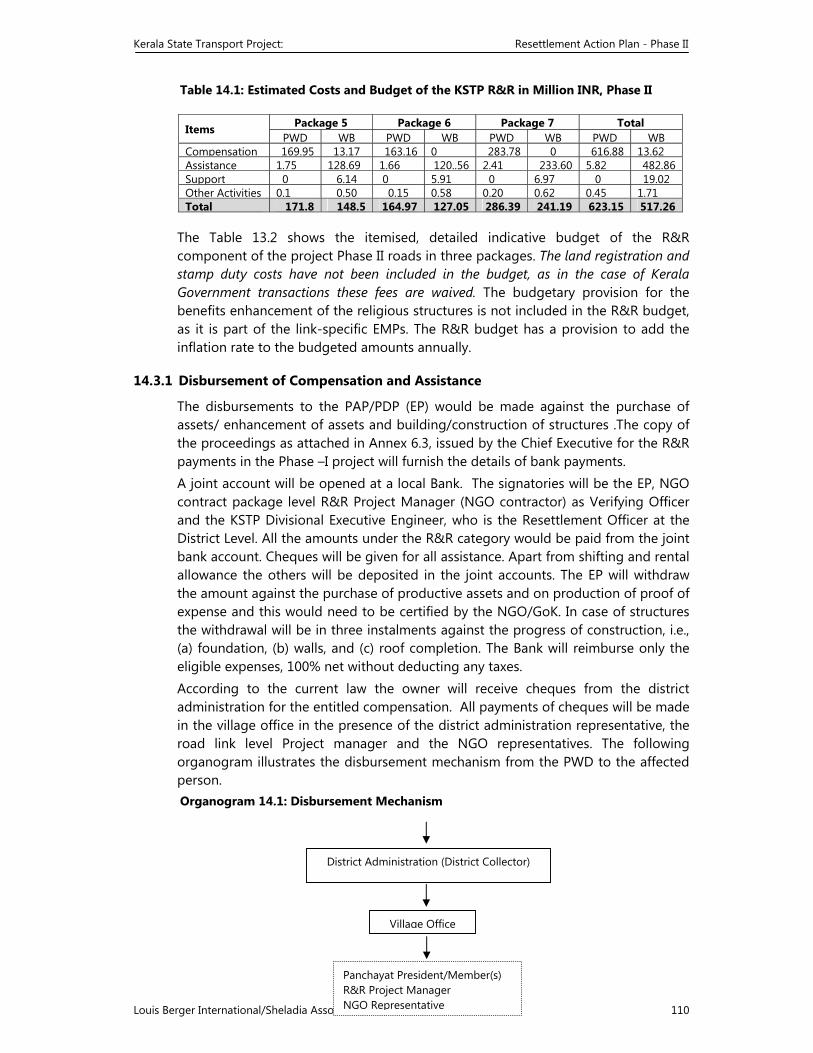
Kerala State Transport Project: Resettlement Action Plan - Phase II
Louis Berger International/Sheladia Associates/CES/ICT 110
Table 14.1: Estimated Costs and Budget of the KSTP R&R in Million INR, Phase II
Items Package 5 Package 6 Package 7 Total PWD WB PWD WB PWD WB PWD WB
Compensation 169.95 13.17 163.16 0 283.78 0 616.88 13.62Assistance 1.75 128.69 1.66 120..56 2.41 233.60 5.82 482.86Support 0 6.14 0 5.91 0 6.97 0 19.02Other Activities 0.1 0.50 0.15 0.58 0.20 0.62 0.45 1.71Total 171.8 148.5 164.97 127.05 286.39 241.19 623.15 517.26
The Table 13.2 shows the itemised, detailed indicative budget of the R&R component of the project Phase II roads in three packages. The land registration and stamp duty costs have not been included in the budget, as in the case of Kerala Government transactions these fees are waived. The budgetary provision for the benefits enhancement of the religious structures is not included in the R&R budget, as it is part of the link-specific EMPs. The R&R budget has a provision to add the inflation rate to the budgeted amounts annually.
14.3.1 Disbursement of Compensation and Assistance
The disbursements to the PAP/PDP (EP) would be made against the purchase of assets/ enhancement of assets and building/construction of structures .The copy of the proceedings as attached in Annex 6.3, issued by the Chief Executive for the R&R payments in the Phase –I project will furnish the details of bank payments. A joint account will be opened at a local Bank. The signatories will be the EP, NGO contract package level R&R Project Manager (NGO contractor) as Verifying Officer and the KSTP Divisional Executive Engineer, who is the Resettlement Officer at the District Level. All the amounts under the R&R category would be paid from the joint bank account. Cheques will be given for all assistance. Apart from shifting and rental allowance the others will be deposited in the joint accounts. The EP will withdraw the amount against the purchase of productive assets and on production of proof of expense and this would need to be certified by the NGO/GoK. In case of structures the withdrawal will be in three instalments against the progress of construction, i.e., (a) foundation, (b) walls, and (c) roof completion. The Bank will reimburse only the eligible expenses, 100% net without deducting any taxes. According to the current law the owner will receive cheques from the district administration for the entitled compensation. All payments of cheques will be made in the village office in the presence of the district administration representative, the road link level Project manager and the NGO representatives. The following organogram illustrates the disbursement mechanism from the PWD to the affected person. Organogram 14.1: Disbursement Mechanism
District Administration (District Collector)
Village Office
Panchayat President/Member(s)R&R Project Manager NGO Representative
Kerala State Transport Project: Resettlement Action Plan - Phase II
Louis Berger International/Sheladia Associates/CES/ICT 111
15 GRIEVANCE REDRESS
15.1 NEED FOR GRIEVANCE REDRESS
A grievance is righteous anger or resentment stemming from a feeling of having been wronged. In case of projects involving land acquisition, involuntary resettlement and loss of livelihoods, grievance relates to perceived exploitation by the Government (PWD) and essentially indicates inadequate payment. The grievance procedure and appeal mechanism are an important aspect related to R & R of the PAPs. The Land Acquisition Act has provisions at different stages of the land acquisition process for the affected persons to object to the proposed acquisition of land and other properties, etc. It also allows the affected persons to receive compensation under protest and to approach the court for settlement.
Even though the land acquisition by Government for public purpose cannot be challenged, in court, an aggrieved person may go to a court of law to challenge the amount of compensation. Experience shows that litigation causes will lead to unnecessary delays and cost overruns in many projects. To avoid such legal procedures a committee for grievance redress has been constituted in each project district, which will provide a forum for people to express their dissatisfaction over compensation and R & R provisions. It does not imply that the affected people will be debarred from approaching the court on the compensation issue.
15.2 GRIEVANCE REDRESS COMMITTEE
Vide Government Order G.O. (MS) No. 41/2002/PWD, dated 23 July 2002 a Grievance Redress Committee (GRC) has been constituted at every project District Headquarters. The GRC comprises the District Collector or his nominated representative, representatives of NGO, panchayath or municipality. The District Collector or his authorised representative will chair the Committee. Local MLA/MPs/ District Panchayath Presidents can be invited specially to participate in this committee.
The GRC may also take an informal role in handling grievances and issues related to land acquisition, to minimise/avoid the litigate measurers as far as possible. The Section 11.2.2 discuss the constitution of another Citizen’s Advisory Committee (CAC) related to land acquisition, which could work together with the GRC.
15.3 GRIEVANCE REDRESS MECHANISM
The NGO working in the area will bring the grievances of the project-affected persons before the GRC/R&R Committee. This will provide for the step-by-step process for registering and addressing the grievances. This mechanism will help to redress the grievance of the party to the possible extent. The PAPs will have access to the committee throughout the project period.
Entitled Person
Kerala State Transport Project: Resettlement Action Plan - Phase II
Louis Berger International/Sheladia Associates/CES/ICT 112
15.4 RESPONSE TIME
The GRC will hear grievances once in 15 days. Since the entire resettlement process has to be completed before the commencement of the construction works, the GRC may meet more frequently depending upon the number of cases to be settled. The GRC will inform the decision to the aggrieved party within 15 days of the hearing.
The organogram illustrates the sequential steps for the grievance redress mechanism:
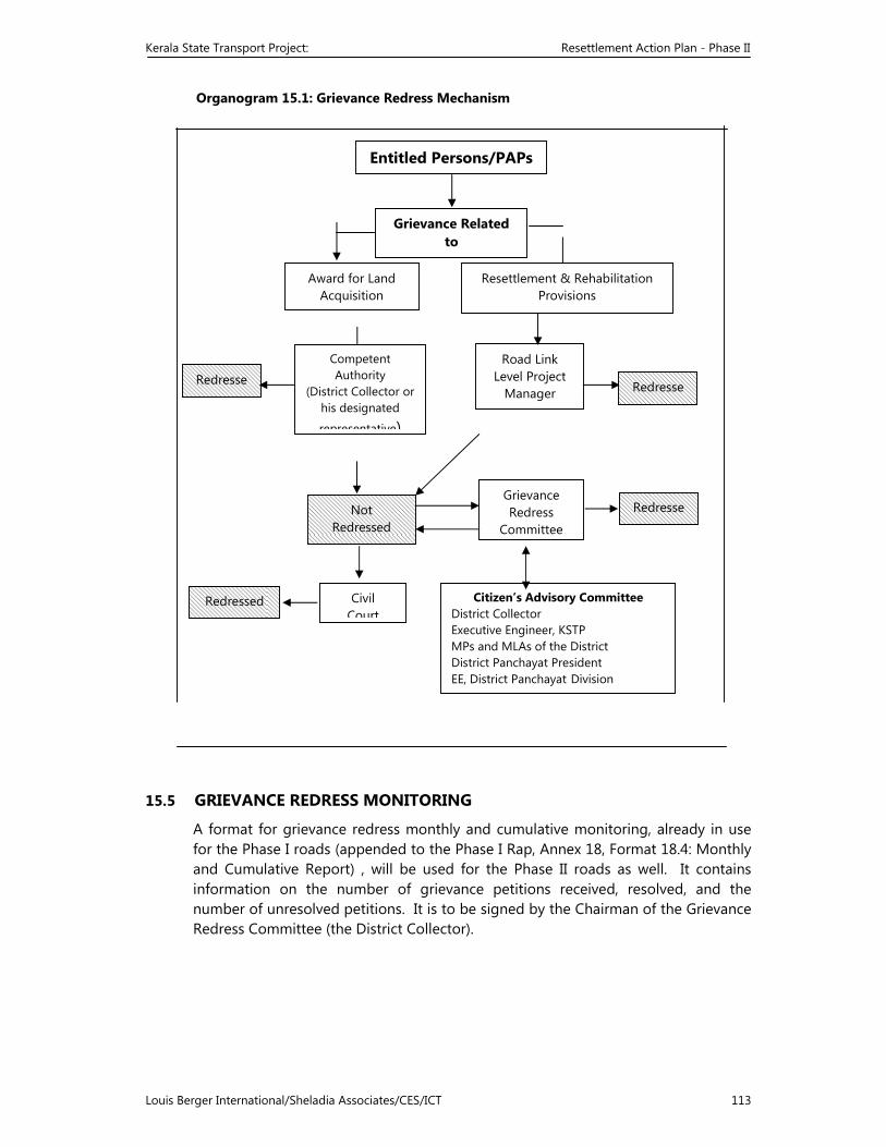
Kerala State Transport Project: Resettlement Action Plan - Phase II
Louis Berger International/Sheladia Associates/CES/ICT 113
Organogram 15.1: Grievance Redress Mechanism
15.5 GRIEVANCE REDRESS MONITORING
A format for grievance redress monthly and cumulative monitoring, already in use for the Phase I roads (appended to the Phase I Rap, Annex 18, Format 18.4: Monthly and Cumulative Report) , will be used for the Phase II roads as well. It contains information on the number of grievance petitions received, resolved, and the number of unresolved petitions. It is to be signed by the Chairman of the Grievance Redress Committee (the District Collector).
Not Redressed
Civil Court
Redressed
Grievance Redress
Committee
Redresse
Citizen’s Advisory Committee District Collector Executive Engineer, KSTP MPs and MLAs of the District District Panchayat President EE, District Panchayat Division
Award for Land Acquisition
Competent Authority
(District Collector or his designated
representative)
Road Link Level Project
Manager
Entitled Persons/PAPs
Resettlement & Rehabilitation Provisions
Grievance Related to
Redresse Redresse
Kerala State Transport Project: Resettlement Action Plan - Phase II
Louis Berger International/Sheladia Associates/CES/ICT 114
16 MONITORING, EVALUATION AND REPORTING
16.1 INTRODUCTION
The Rehabilitation Action Plan (RAP) is a time bound plan to be implemented in a structured and participatory way. Non-governmental Organisations (NGOs) are selected and engaged for implementing the RAP in the field. To watch the progress of implementation and ensure the process, structured Monitoring and evaluation (M&E) assumes significance. The RAP implementation is a critical activity in involuntary resettlement. Monitoring involves periodic checking to ascertain whether activities are carried out according to the RAP. It provides the necessary feedback for project management to keep the programme on schedule.
Evaluation is essentially a summing up job at the end of the project to assess whether the activities planned and scheduled were actually completed, fulfilling the objectives.
One of the objectives of the Kerala State Transport Project is to ensure that the affected individuals and households regain, and preferably improve upon, their living standards. The measures detailed in this Report are designed to meet this objective. An M&E programme will, accordingly, be implemented to (a) record and assess project inputs and the number of persons affected and compensated, and (b) confirm that former living standards are being re-established.
There are two broad activities to be monitored: first, the progress of land acquisition and second, the R&R activities. The range of activities and issues that will have to be recorded and monitored include:
Land acquisition and transfer procedures; Disbursement of compensation and assistance Construction of replacement buildings by the displaced households; Re-establishment of displaced households and business enterprises; Rehabilitation of income levels. Two broad categories of indicators, (a) input and output indicators and (b) outcome/impact indicators, will be used to monitor the project implementation. Input and output indicators relate to the physical progress of the works and include such items as the extent of land acquisition and compensation paid, the number of families displaced and resettled, the extent of government land identified and allotted to the project affected families, other R&R assistance extended and the related financial aspects. The outcome/impact indicators relate to overall project objectives as stated in the R&R policy.
Monitoring will be done both internally and externally. An external agency will be contracted to monitor and evaluate the R&R programmes. Periodic changes will be made in the RAP, based on that evaluation.
16.2 M&E MECHANISMS AND REPORTING
Internally, the R&R Coordinator at the PMT will be responsible overall for monitoring the progress of land acquisition and R&R. The Director of Land
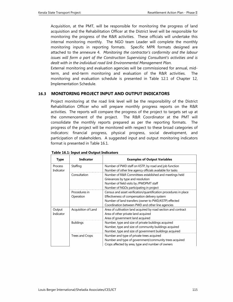
Kerala State Transport Project: Resettlement Action Plan - Phase II
Louis Berger International/Sheladia Associates/CES/ICT 115
Acquisition, at the PMT, will be responsible for monitoring the progress of land acquisition and the Rehabilitation Officer at the District level will be responsible for monitoring the progress of the R&R activities. These officials will undertake this internal monitoring monthly. The NGO team Leader will complete the monthly monitoring inputs in reporting formats. Specific MPR formats designed are attached to the annexure 4. Monitoring the contractor’s conformity and the labour issues will form a part of the Construction Supervising Consultant’s activities and is dealt with in the individual road link Environmental Management Plan. External monitoring and evaluation agencies will be commissioned for annual, mid-term, and end-term monitoring and evaluation of the R&R activities. The monitoring and evaluation schedule is presented in Table 12.1 of Chapter 12, Implementation Schedule.
16.3 MONITORING PROJECT INPUT AND OUTPUT INDICATORS
Project monitoring at the road link level will be the responsibility of the District Rehabilitation Officer who will prepare monthly progress reports on the R&R activities. The reports will compare the progress of the project to targets set up at the commencement of the project. The R&R Coordinator at the PMT will consolidate the monthly reports prepared as per the reporting formats. The progress of the project will be monitored with respect to these broad categories of indicators: financial progress, physical progress, social development, and participation of stakeholders. A suggested input and output monitoring indicators format is presented in Table 16.1.
Table 16.1: Input and Output Indicators
Type Indicator Examples of Output Variables
Process Indicator
Staffing Number of PWD staff on KSTP, by road and job function Number of other line agency officials available for tasks
Consultation Number of R&R Committees established and meetings held Grievances by type and resolution Number of field visits by /PWDPMT staff Number of NGOs participating in project
Procedures in Operation
Census and asset verification/quantification procedures in place Effectiveness of compensation delivery system Number of land transfers (owner to PWD/KSTP) effected Coordination between PWD and other line agencies
Output Indicator
Acquisition of Land Area of cultivation land acquired by road section and contract Area of other private land acquired Area of government land acquired
Buildings Number, type and size of private buildings acquired Number, type and size of community buildings acquired Number, type and size of government buildings acquired
Trees and Crops Number and type of private trees acquired Number and type of government/community trees acquired Crops affected by area, type and number of owners
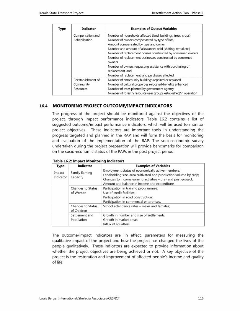
Kerala State Transport Project: Resettlement Action Plan - Phase II
Louis Berger International/Sheladia Associates/CES/ICT 116
Type Indicator Examples of Output Variables
Compensation andRehabilitation
Number of households affected (land, buildings, trees, crops) Number of owners compensated by type of loss Amount compensated by type and owner Number and amount of allowances paid (shifting, rental etc.) Number of replacement houses constructed by concerned owners Number of replacement businesses constructed by concerned owners Number of owners requesting assistance with purchasing of replacement land Number of replacement land purchases effected
Reestablishment ofCommunity Resources
Number of community buildings repaired or replaced Number of cultural properties relocated/benefits enhanced Number of trees planted by government agency Number of forestry resource user groups established/in operation
16.4 MONITORING PROJECT OUTCOME/IMPACT INDICATORS
The progress of the project should be monitored against the objectives of the project, through impact performance indicators. Table 16.2 contains a list of suggested outcome/impact performance indicators, which will be used to monitor project objectives. These indicators are important tools in understanding the progress targeted and planned in the RAP and will form the basis for monitoring and evaluation of the implementation of the RAP. The socio-economic survey undertaken during the project preparation will provide benchmarks for comparison on the socio-economic status of the PAPs in the post project period.
Table 16.2: Impact Monitoring Indicators Type Indicator Examples of Variables
Impact Indicator
Family Earning Capacity
Employment status of economically active members; Landholding size, area cultivated and production volume by crop; Changes to income earning activities – pre- and post-project; Amount and balance in income and expenditure.
Changes to Status of Women
Participation in training programmes;Use of credit facilities; Participation in road construction; Participation in commercial enterprises.
Changes to Status of Children
School attendance rates – males and females;
Settlement and Population
Growth in number and size of settlements;Growth in market areas; Influx of squatters.
The outcome/impact indicators are, in effect, parameters for measuring the qualitative impact of the project and how the project has changed the lives of the people qualitatively. These indicators are expected to provide information about whether the project objectives are being achieved or not. A key objective of the project is the restoration and improvement of affected people’s income and quality of life.
Kerala State Transport Project: Resettlement Action Plan - Phase II
Louis Berger International/Sheladia Associates/CES/ICT 117
16.5 EXTERNAL MONITORING AND EVALUATION
As indicated, an external organisation with experience in resettlement and rehabilitation and other social development programmes will be engaged to carry out the evaluation and reporting of the implementation of the RAP. This agency will be independent of the project.
This external agency will do monitoring and evaluation of the PMT maintained reporting formats as well as the output/impact of the project as suggested in Table 15.2. This external exercise will be done thrice during the life of the project. The first evaluation will be an annual evaluation and will take place after the PDFs have been displaced from the CoI. Any problems encountered will be assessed and necessary changes will be recommended to the PIU for consideration. This is to ensure that these problems do not recur during the remaining part of the project.
The other evaluations will be the standard mid-term and the end-of-project evaluation. It is recommended that the external evaluation be based on a recognised sampling method to select the items of the performance indicators to be monitored and the EPs within each road link to be monitored.
The parameters and indicators suggested for external evaluation are illustrative only. The evaluating agency, may modify it appropriately.
The external evaluation agency will submit three evaluation reports to the PMT. The reports should contain all the data collected and critical analysis of the same. It is expected that the agency will present a comparative analysis with reference to the pre-project and post-project status in the socio-economic conditions of the PAPs. The PMT will initiate corrective actions, if necessary, based on the recommendations of this agency.
Kerala State Transport Project: Resettlement Action Plan - Phase II
Louis Berger International/Sheladia Associates/CES/ICT 118
17 MISCELLANEOUS BENEFITS ENHANCEMENT
17.1 ROADSIDE FACILITIES
The project has provided for a number of roadside amenities and facilities for the local people. These include rest areas, service roads, footpaths, lined and/or covered roadside drains in the built up areas, pick up bus stops with shelters, motorised rickshaw and taxi stands, bus bay, etc. All these facilities have been incorporated in the design of the roads, bill of quantities and specifications of the main civil works contract. The Environmental Management Plan of the individual road links has detailed information on these issues.
17.2 CONSERVATION AND ENHANCEMENT OF CPR
The common property resources (CPR) along the project roads include trees, wells, water taps, bus stops, schools, hospitals, and religious properties. The project affected roadside wells and water taps will be replaced by the project authorities in cooperation with the local government (panchayat or municipality) and the Kerala Water Authority. The Environment Management Plan has detailed information on these issues, including roadside tree planting.
Religious properties are not strictly common properties, although they are open to the public. Despite best efforts made in the engineering design to avoid land take from them, as many as 106 of them were estimated to be affected, mostly in the form of losing their boundary wall. A discussion is made here regarding the benefits enhancement of the cultural properties.
17.2.1 Cultural Properties Rehabilitation Policy
The project needs to develop a policy for the rehabilitation of cultural properties that will be affected by the road improvement programme. This could be made a part of the broad R&R Principle and Policy Framework.
The KSTP has been guided by the Bank’s Draft Operational Policy 4.11, which exclusively deals with the cultural properties, in its handling of the affected cultural properties due to the project. Further, as desired by the Bank, this section of the RAP has been prepared as a separate safeguard policy exclusively for the Kerala State Transport Project.
17.2.2 Types Of Religious Properties Identified In The Project Location
The environmental and social surveys and the detailed social impact studies have identified all cultural properties (total 110) that will be affected by the Phase II roads improvement. These are presented in Table 17.1. Their magnitude of being affected widely varies. The following types of cultural properties are found on the project roads:
Temple Church Mosque
Shrines of all major religions
Tree shrines/sacred groves Hyundi of all the three religions
Except the tree shrines, the others are not strictly “common property” because they are owned and managed by their respective registered “Society” or “Trust”. The
Kerala State Transport Project: Resettlement Action Plan - Phase II
Louis Berger International/Sheladia Associates/CES/ICT 119
public only has access to them. As the table shows, there are 22 Hindu cultural properties, 59 Christian and 13 Muslim cultural properties. Three Hindu cultural properties, including the tree shrines and a hyundi, have squatted on the Government land. Many of the shrines are actually roadside hyundis, which are squatters and could be easily relocated. Other properties are affected in terms of losing boundary walls or land. There are also affected vacant plots of land owned by the religious properties.
It was noticed during the surveys that some cultural properties, are now serving the role of traffic islands. The project recommends landscaping of those sites as a benefit enhancement measure.
17.2.3 Definitions of Cultural Properties
Temples are Hindu places of worship. There are private as well as community temples. Most of the temples are different from one another by way of age and idols (Shiva, Vishnu, Krishna etc). In a majority of the cases, the location has specific significance. Because of the same reason temples are usually located away from the Roads.
Churches are Christian places of worship. There are no private Churches. The churches usually belong to different groups within Christianity (Catholic, Marthoma, Syrian, Pentecostal, etc). Except few cases the location has no specific significance for a church.
Mosques are the places of worship of the Muslims. There are Sunny Mosques and Mujahiddin mosques. With regard to the rehabilitation policy, all mosques can be treated as belonging to the same type.
Shrines are usually small structures, located in the vicinity of the main religious structure associated with all the three major religions of the State. The shrines usually serve the purpose of helping the road users obtain a quicker religious service, besides indicating the larger presence of the religious community in the locality.
The shrines are a most important part of any place of worship. Normally a small shrine develops to a bigger place of worship with earlier shrine remaining as the most important part of the property.
Tree shrines are usually associated with the Hindus. There are a few tree shrines located along the project roads. People worship the idols installed at the base of the trees as well as the trees. These trees have a special significance to the local community, which will usually oppose the removal of such tree shrines. The landscaping would be ideal. This will require extensive community consultation.
Sacred groves are also usually associated with the Hindus. Even today, the Nair community in Kerala worship snakes and other demigods. For this purpose they preserve a small forest, known as sacred groves. This represents the close association of man with nature. Usually, landscaping would be ideal for the sacred groves.
Kerala State Transport Project: Resettlement Action Plan - Phase II
Louis Berger International/Sheladia Associates/CES/ICT 120
Hyundi: these are concrete collection boxes of religious centres, constructed adjacent to the road to facilitate the passing believers to drop coins. Almost all the religious centres adjacent to the road will have a hyundi very near to the road. On an average, these structures are of one square metre area, placed strategically on the public right of way, essentially targeting the truck drivers and other motorists who do not have the time to visit the places of worship.
17.3 IMPACTS OF THE PROJECT ON THE CULTURAL PROPERTIES
17.3.1 The impacts on the cultural properties are of the following categories:
Only Compound wall affected Compound wall and part of the compound affected Part of structure affected Sanctum sanctorum affected – can be categorised as the complete structure affected Only land affected Complete cultural property affected Loss of access/entrance, if the existing access is from the project roadside. Other impacts to cultural properties include Induced impacts: The construction of road or realignments or bypasses sometime will result in induced impacts obstructing the cultural properties in various ways. In the instances of such events the highway authority will assist through consultation and other means (highway Protection Act 2000) restoring the importance of the shrine. This will be mostly applicable along the new alignments.
17.3.2 The Project Approach to Mitigating Cultural Properties
In all cases, the mitigation actions are framed unique to that particular situation with respect to the available space, the unique characteristics of the religious structure affected and the local public and religious judgement. In other words, the project policy is unique to consider the widely varying situations for each cultural property. The loss of land and assets of the cultural properties will be treated on par with the loss of other land and assets for the purpose of compensation and assistance. However, the project will, in addition, strive to enhance benefits to the affected cultural properties in consultation with their respective managements. The Project has a clear strategy to take people and affected parties into confidence before taking any decision on shifting of structures especially religious structures. There would not be any involuntary shifting or relocation especially in the case of cultural properties. An outline benefits enhancement for the cultural properties is shown in the following table. Table 17.2: Strategy For Restoration, Relocation Or Reconstruction of Cultural Properties Sl No Extent of Impact on
Cultural Properties Consultation conducted and
Consensus Obtained Benefit Enhancement
1 Only Compound wall and land beneath affected
Reconstruction of wall parallel to the present compound wall. Loss of land compensated.
Access/entrance provided through one of the sides
2 Compound wall and part of compound affected
Reconstruction of wall parallel to the existing wall. Loss of land compensated. If
- Do -
Kerala State Transport Project: Resettlement Action Plan - Phase II
Louis Berger International/Sheladia Associates/CES/ICT 121
Sl No Extent of Impact on Cultural Properties
Consultation conducted and Consensus Obtained
Benefit Enhancement
land is available adjacent to the property, will be purchased.
3 Structure affected Alternate structure constructed and all pre-status restored.
- Do -
4 Sanctum sanctorum affected
Complete structure reconstructed and all pre-status restored.
- Do -
5 Only land affected Alternate land provided, preferably, if available, adjacent to the existing location.
Landscaping
6 Complete cultural property affected
Relocation of site identified by the cultural property authorities and rebuilding of the property.
Landscaping
The Environmental Management Plan of the road links have made detailed analysis of the strategy to mitigate the cultural properties.
17.4 ROAD SAFETY
Kerala roads are high accident-prone and the project has taken measures to minimise road traffic accident through better road geometry, traffic islands, footpaths, organising awareness campaign and driver education. An independent road safety auditor prepared a Road Safety Action Plan and the road design has adapted to the recommendations of the Action Plan.
17.5 AWARENESS CAMPAIGN FOR HIV/AIDS
Kerala State AIDS Control Society (KSACS) have estimated around one-lakh HIV positive cases in Kerala. The total death due to AIDS so far is 529 cases. Road transport sector bear a significant role in the transmission of HIV as the truck drivers of inter State services are found to be the carriers of this deadly virus. NATPAC has estimated that on an average, 800 trucks come to Kerala from outside and each truck will have two helpers and a driver totalling to 2400 persons a day. Among them 2 to 3 percent are carriers of HIV. Even though Kerala has not yet become a high-risk State for HIV/AIDS, it is right time to initiate safety measurers through intense campaigning, especially in the road transport sector and KSTP recognises this need. .
NGOs need to identify risk prone areas such as taxi stands, bus/truck stands, inter state parking areas etc in their respective link and chalk out an effective campaign to alert risky people about the seriousness of the issue and adopt safety measurers. Each NGO will prepare a Year calendar of activities setting targets every month and act accordingly. The specialised agencies in the sector such as KSACS, State Management Agency (SMA) etc will provide required technical and material support. PMT and CSC will facilitate this convergence. The activities will be monitored through the monthly progress reports. In the Construction camp sights the contractors will ensure all precautionary measurers and the CSC Sociologist will give them required advice. NGOs will support them in organising awareness classes. RAP has earmarked Rs 0.65 million for AIDS awareness, which has to be utilised for specific activities avoiding duplication. (For more details refer Chapter 6 of Phase I RAP attached as Annex 10 in Volume I)
17.6 CONSTRUCTION CAMP
For large-scale construction like that of highways, construction camps should be planned to house the construction labourers. In most cases the labour force will be
Kerala State Transport Project: Resettlement Action Plan - Phase II
Louis Berger International/Sheladia Associates/CES/ICT 122
supplied from outside by the contractors and will stay in the camps throughout the period of construction. To meet the basic necessities of these mobile people, certain provisions should be made in the construction camps.
17.6.1 Provisions Incorporated in the KSTP
Social and environmental issues during the road construction stage generally involve equity, safety and public health issues. The road construction agencies are required to comply with the laws of the land, which include the following: • Workmen’s Compensation Act, 1923 (provides compensation in case of
injury by accident arising out of and during the course of employment). • Payment of Gratuity Act, 1972 • Employees PF and Miscellaneous Provision Act, 1952. • Maternity Benefit Act, 1951 • Contract Labour (Regulation and Abolition) Act, 1948 • Minimum Wages Act, 1948 • Payment of Wages Act, 1936 • Equal Remuneration Act, 1979 • Industrial Disputes Act, 1947 • Child Labour (Prohibition and Regulation) Act, 1986 • Inter-State Migrant Workmen’s (Regulation of Employment and Conditions
of Service) Act, 1979 • The Building and Other Construction Workers (Regulation of Employment
and Conditions of Service) Act, 1996
• Environment Protection Act, 1986 • Chemical Accidents (Emergency Planning, Preparedness and Response)
Rules, 1996.
17.6.2 Contract Obligations in the KSTP
In addition to and in supplementation of all the provisions in the EMAP and RAP, the following equity and welfare measures will apply to the construction activities in the KSTP. First aid Accommodation Potable water Washing and bathing places Toilet Shelters for rest Creches Canteen Public safety and health/hygiene provisions. All these measures are equally important, but the health/hygiene problem assumes more importance in the context of the predominantly lone male workforce in the construction industry. These labourers play a significant role in spreading sexually transmitted diseases and HIV/AIDS. While the project has a modest budget
Kerala State Transport Project: Resettlement Action Plan - Phase II
Louis Berger International/Sheladia Associates/CES/ICT 123
provision to generate awareness campaign against HIV/AIDS in the immediate area of the project, the contractor will be responsible to take steps to prevent the spread of HIV/AIDS in the construction camp. The HIV/AIDS action plan is in place for the KSTP Phase I roads and will be continued for the Phase II roads.
17.7 CONTROL OF CHILD LABOUR
Minors, that is, persons below the age of 14 years should be restricted from getting involved in the construction activities. Measures should be taken to ensure that no child labourer is engaged in the activities. The Environment Management Plan of the individual road links discusses in detail the safeguard measures of this aspect as well as its monitoring by the Construction Supervision Consultant.
Kerala State Transport Project: Resettlement Action Plan - Phase II
Louis Berger International/Sheladia Associates/CES/ICT 124
VOLUME I (ANNEXURES) ANNEX 4: Format for monthly Progress Report by the NGO ANNEX 5: Social Impact Assessment Data Sheet of the NGO ANNEX 6.1: Rehabilitation & Resettlement: Principles and Policy Framework
(The complete document as approved by the Kerala State Cabinet in August 2000)
ANNEX 6.2: Format for the micro plans Annex 6.2(a) – Title holders Annex 6.2(b) – Non Title holders Annex 6.2(c) – Cultural Properties Annex 6.2(d) – Community Properties
ANNEX 6.3: Procedure for disbursement of documentation of the R&R assistance, issued by the Finance Controller, KSTP
ANNEX 10: Chapter 6 of Phase I – RAP – The highways Improvement and the
impact of STD/HIV/AIDS