COASTS. Theme Overview COASTS COASTAL PROCESSES COASTAL LANDFORMS COASTAL MANAGEMENT.

3/26/15
1
COASTAL LANDFORMS (32)
I Main topics A Why study coastal landforms?
B Sediment budget and system response
C Coastal landforms
3/26/15 GG454 1
II Why study coastal landforms?
A Dynamic systems B Reflect geologic history and human influence 1 Tectonics 2 Sea level change 3 Sediment budget
C Provide a basis for predicQng “long-‐term” future behavior of a coastal system
D Dense populaQons
3/26/15 GG454 2

3/26/15
2
III Sediment budget and system response
A Where sediment input > sediment loss: accreQon
B Where sediment loss > sediment input: erosion
C Where subsidence rate > sedimentaQon rate: submergence
3/26/15 GG454 3
Mississippi River Delta New Orleans, Louisiana
hYp://en.wikipedia.org/wiki/Mississippi_River_Delta
IV Coastal landforms
3/26/15 GG454 4

3/26/15
3
A Beaches, berms, and bars
1 Beach: AccumulaQon of rock fragments that can be moved by ordinary wave acQon
2 Berm: The above water porQon of a beach
3 Bar: The below water porQon of a beach; bars typically extend to depths of ~10m below low Qde level
4 Sand commonly moves offshore in winter, onshore in summer (berm!" bar)
3/26/15 GG454 5
hYp://w3.salemstate.edu/~lhanson/gls214/gls214_beach1.htm
hYp://en.wikipedia.org/wiki/LiYoral_zone
B Wave-‐cut bench 1 A narrow flat area
created by wave erosion 2 Result from sea-‐level fall
and/or land rise
3/26/15 GG454 6
hYp://sadtp.soest.hawaii.edu/space/hawaii/ves/oahu/oahu_se/se.ground.photographs3.html
Wave-‐cut bench, Hanauma Bay Wave-‐cut bench, Hanauma Bay

3/26/15
4
C Wave-‐cut terrace or pladorm
3/26/15 GG454 7
hYp://en.wikipedia.org/wiki/Wave-‐cut_pladorm
Wave-‐cut pladorm Aberystwyth, Wales
hYp://maps.unomaha.edu/maher/GEOL1010/lecture14/waveterraceUSGS.jpg
1 A broad flat area created by wave erosion 2 Result from sea-‐level fall and/or land rise
Wave-‐cut terrace Wilder Ranch State Park, California
D Deltas
1 Sedimentary bodies deposited at a river mouth a Sediment sources
i Natural and arQficial ii Dynamic
B Influences i Stream-‐dominated:
distributaries prominent: (“birdfoot” deltas)
ii Wave-‐dominated: delta shape asymmetric
3/26/15 GG454 8
hYp://en.wikipedia.org/wiki/River_delta
Mississippi River Delta

3/26/15
5
E Spits
1 AYached, shore-‐parallel ridges of sand
2 Require a supply of sand, a transporQng current, and a deposiQonal site
3/26/15 GG454 9
hYp://en.wikipedia.org/wiki/Spit_(landform)
Dungeness Spit, Washington
Farewell Spit, South Island, New Zealand
F Barrier islands
1 Barrier islands: low, elongate, shore-‐parallel islands
2 Emergence of offshore bars
3 Submergence of beaches and beach dunes
4 Help protect landward coast from erosion
3/26/15 GG454 10
hYp://commons.wikimedia.org/wiki/File:Baie_de_Mobile.jpg
Barrier islands, Mobile Bay, Alabama

3/26/15
6
G Lagoons
1 Lagoon: a shallow body of water separated from a larger body of water by a shallow or exposed shoal, coral reef, or similar feature
2 Commonly elongate, annular, or circular in map view
3/26/15 GG454 11
hYp://en.wikipedia.org/wiki/Lagoon#/media/File:Boraboralue_gerade.jpg
Lagoon, Bora Bora
H Reefs
1 Indicate approximate level of sea level at the Qme of reef formaQon
2 Elevated reefs indicate former sea level highstands and/or coastal emergence
3 Submerged reefs indicate former sea level lowstands or coastal subsidence
3/26/15 GG454 12
hYp://www.onlyinhawaii.org/wp-‐content/uploads/2014/06/Popoia-‐Island-‐Oahu-‐Hawaii.jpg
Flat Island, Kailua Bay

3/26/15
7
H Reefs
1 Indicate approximate level of sea level at the Qme of reef formaQon
2 Elevated reefs indicate former sea level highstands and/or coastal emergence
3 Submerged reefs indicate former sea levels and/or coastal subsidence
3/26/15 GG454 13
hYp://www.soest.hawaii.edu/coasts/data/oahu/pictures/ oblique_photos/Windward/images/092_Kailua_Beach_Park.jpg
Flat Island, Kailua Bay
I Estuaries I Inundated stream valleys
2 Typically reflect recent sea level rise
3 Sediment “traps”
3/26/15 GG454 14
hYp://en.wikipedia.org/wiki/San_Francisco_Bay hYp://en.wikipedia.org/wiki/Chesapeake_Bay#/media/File:Chesapeakelandsat.jpeg
Chesapeake Bay San Francisco Bay
3/26/15
8
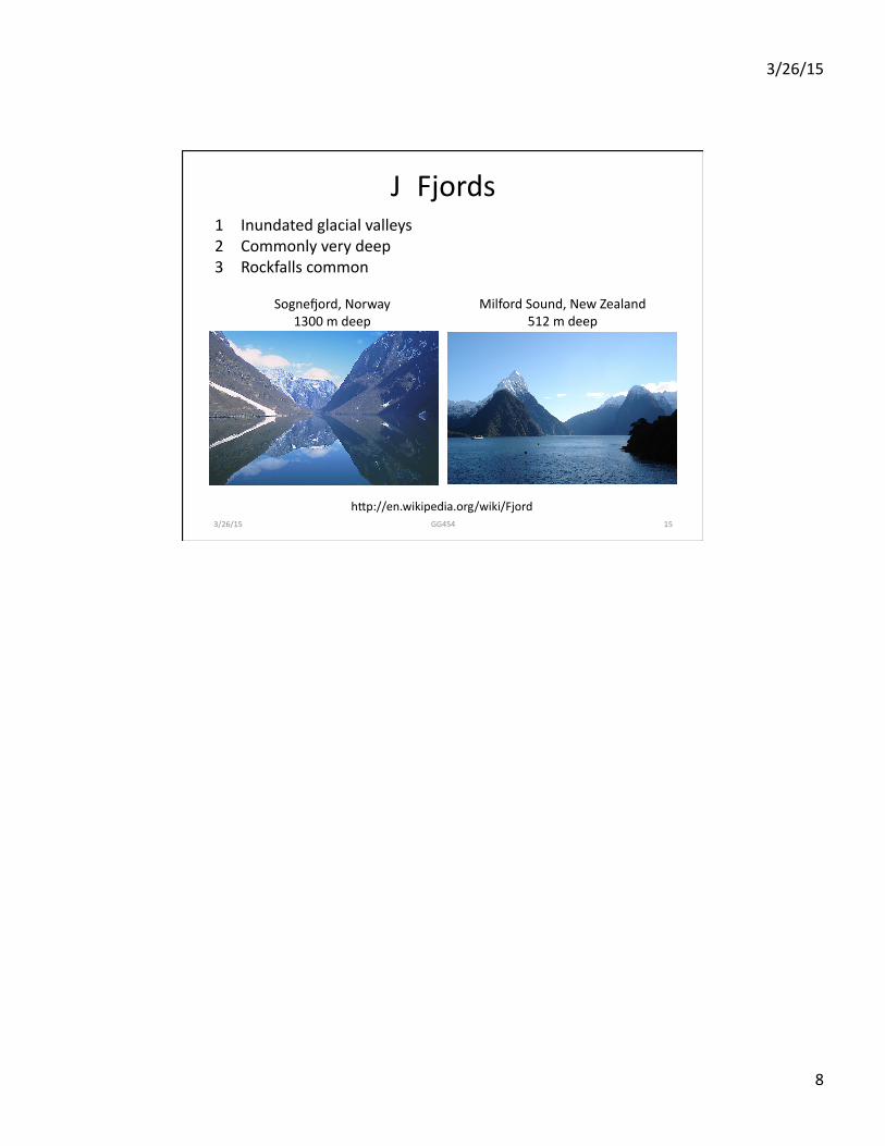
J Fjords
3/26/15 GG454 15
hYp://en.wikipedia.org/wiki/Fjord
1 Inundated glacial valleys 2 Commonly very deep 3 Rockfalls common
Sognesord, Norway 1300 m deep
Milford Sound, New Zealand 512 m deep