
IGOS Atmospheric Chemistry Theme Report: … Global Observing Strategy Partnership Eleventh IGOS...
70
Integrated Global Observing Strategy Partnership Eleventh IGOS Partners Meeting FAO HQ Rome, Italy Thursday, 27th May 2004 IGOS-P 11 Doc. Item 5.2 IGOS Atmospheric Chemistry Theme Report: Integrated Global Atmospheric Chemistry Observations (IGACO) ACTION PROPOSED I. The meeting is invited to approve the IGOS Atmospheric Chemistry Theme Report. SUMMARY AND PURPOSE IGOS initiated the Atmospheric Chemistry Theme in 2001 based on the WMO/CEOS Report GAW #140 “A Strategy For Integrating Satellite And Ground-Based Observations Of Ozone" that represented the outcome of an international consultation of the community. WMO/GAW was given the lead to move the Theme Report forward. They were joined by ESA in January 2003. After an effort by a panel of experts, several interim reviews by CEOS-SIT and IGOS-P as well as an independent international group of atmospheric chemistry reviewers, the co-convenors, WMO and ESA, submit this final Atmospheric Chemistry Theme Report for approval by the IGOS Partnership in Rome May 2004.
-
Upload
phungtuong -
Category
Documents
-
view
217 -
download
1
Transcript of IGOS Atmospheric Chemistry Theme Report: … Global Observing Strategy Partnership Eleventh IGOS...

Integrated Global Observing Strategy Partnership Eleventh IGOS Partners Meeting FAO HQ Rome, Italy Thursday, 27th May 2004
IGOS-P 11Doc.
Item 5.2
IGOS Atmospheric Chemistry Theme Report:
Integrated Global Atmospheric Chemistry Observations (IGACO)
ACTION PROPOSED I. The meeting is invited to approve the IGOS Atmospheric Chemistry Theme Report.
SUMMARY AND PURPOSE IGOS initiated the Atmospheric Chemistry Theme in 2001 based on the WMO/CEOS Report GAW #140 “A Strategy For Integrating Satellite And Ground-Based Observations Of Ozone" that represented the outcome of an international consultation of the community. WMO/GAW was given the lead to move the Theme Report forward. They were joined by ESA in January 2003. After an effort by a panel of experts, several interim reviews by CEOS-SIT and IGOS-P as well as an independent international group of atmospheric chemistry reviewers, the co-convenors, WMO and ESA, submit this final Atmospheric Chemistry Theme Report for approval by the IGOS Partnership in Rome May 2004.

Integrated Global Atmospheric Chemistry Observations IGACO
The Changing Atmosphere
Global tropospheric NO2 clearly showing regions of industrial activity Image kindly supplied by Steffen Beirle and Thomas Wagner, IUP, Heidelberg.
The IGOS Atmospheric Chemistry Theme Report
Final Draft (for the 11th IGOS Partners Meeting)
April 2004

IGACO Theme Report 2
Table of Contents Preface by the Co-Chairs of IGOS............................................................................................. 3
Foreword by the IGACO Theme Coordinators.......................................................................... 4
The Executive Summary ............................................................................................................ 6 Motivation......................................................................................................................... 6 The grand challenges in atmospheric chemistry............................................................... 6 The need for IGACO ........................................................................................................ 7 The chemical species and ancillary parameters required for IGACO .............................. 7 The essential components of IGACO ............................................................................... 8 Summary of IGACO recommendations ........................................................................... 9 The implementation of IGACO ........................................................................................ 9
1. The Atmospheric Environment in the 21st Century ....................................................... 11 1.1 Man’s influence on the atmosphere....................................................................... 11 1.2 IGACO in the context of the Earth system............................................................ 12 1.3 The goal, the uses and the applications of the results from IGACO ..................... 13
2. The Grand Challenges in Atmospheric Chemistry ......................................................... 15 2.1 Air quality: the globalisation of air pollution........................................................ 15 2.2 Oxidising efficiency: the atmosphere as a waste processor .................................. 17 2.3 The stratospheric ozone shield .............................................................................. 18 2.4 Coupling between atmospheric chemistry and climate......................................... 20
3. The Existing Atmospheric Observation System............................................................. 22 3.1 Ground-based instrumentation .............................................................................. 22 3.2 Airborne instrumentation ...................................................................................... 23 3.3 Satellite instrumentation........................................................................................ 24 3.4 Modelling and data assimilation............................................................................ 26
4. Atmospheric Chemical Observations for Targeted Parameters...................................... 29 4.1 Introduction ........................................................................................................... 29 4.2 Specific chemical species and other parameters ................................................... 29 4.3 Accuracy requirements.......................................................................................... 48
5. IGACO and its Implementation...................................................................................... 53 5.1 A global system is required ................................................................................... 53 5.2 The proposed architecture for IGACO.................................................................. 54 5.3 Implementation...................................................................................................... 58
6. Appendices...................................................................................................................... 64 6.1 Glossary................................................................................................................. 64 6.2 Selected reading .................................................................................................... 67 6.3 Authors & Reviewers ............................................................................................ 68

IGACO Theme Report 3
Preface by the Co-Chairs of IGOS The Integrated Global Observing Strategy (IGOS) is a partnership of international organisations that are concerned with global environmental change issues. It links research, long-term monitoring and operational programmes, bringing together the producers of global observations and the users that require them, to identify products needed, gaps in observations and mechanisms and to respond to needs in the science and policy communities. Its principal objectives are to integrate satellite, airborne and in situ observation systems. The IGOS partners comprise the Global Observing Systems (GOS), the international organisations which sponsor the Global Observing Systems, the Committee on Earth Observation Satellites (CEOS) and International Global Change Research programmes. The IGOS Partners recognise that a comprehensive global Earth observing system is best achieved through a step-wise process focused on practical results. The IGOS themes allow for the definition and development of a global strategy for the observation of selected environmental issues that are of common interest to the IGOS partners and to user groups. Examples of such themes include the Oceans, Coral Reefs, the Carbon and Water Cycles, Coastal Zone and Atmospheric Chemistry.The IGOS Atmospheric Chemistry theme was approved by IGOS in 2001. After six working group meetings, and several interim reviews by IGOS partners, the present theme report was approved for implementation by the IGOS partnership in May 2004. In 2003, the participants at the Earth Observation Summit launched the intergovernmental ad hoc Group on Earth Observations (GEO), with the goal of furthering the creation of a comprehensive, coordinated, and sustained Earth observing system or systems. IGACO strives to serve the GEO aims for atmospheric composition. Further information on IGOS can be obtained from: http://www.igospartners.org.The IGACO theme report is available from: (to be decided)
Dietrich E. Leihner IGOS Co-chair FAO Director Research, Extension and Training Divisionviale delle Terme di Caracalla 00100 Rome Italy
Xu Guanhua, IGOS Co-chair Minister for Science & Technologyr Fuxing Road 15b Beijing 100862 People's Republic of China

IGACO Theme Report 4
Foreword by the IGACO Theme Coordinators Long term measurements have clearly shown that human activities are changing the composition of the Earth’s atmosphere. Research has demonstrated the important consequences of such changes for climate, human health, the balance of ecosystems and the ability of the atmosphere to cleanse itself of harmful pollutants and greenhouse gases. The awareness that chemical species in the atmosphere are key elements of the Earth system, and public concern about the impact of man, has led international organisations, such as WMO, UNEP and ICSU, to support national and international research programmes and assessments. These in turn triggered international conventions (e.g. Vienna Convention on Ozone Depletion, United Nations Framework Convention on Climate Change) and national directives.
In a declaration published on July 31, 2003, the International Earth Observation Summit emphasised the vital importance of Earth observation activities, encouraging the development of a comprehensive, coordinated, and sustained Earth observation system.
The “Integrated Global Atmospheric Chemistry Observations” (IGACO) theme is a component of the Integrated Global Observing Strategy (IGOS) partnership; it was approved as the fourth theme of IGOS in June 2001, following those for the Ocean, the Global Water Cycle, and the Global Carbon Cycle. A panel of international scientists were convened by the WMO and ESA to produce this theme report; the panel is grateful for the able assistance of a number of distinguished reviewers, and for many constructive comments from the secretariat and executive committee of the IGOS partnership, as well as the Strategic Implementation Team of CEOS.
The objective of this report is to initiate a process leading towards a globally coordinated development of future observation and integration programmes, whose components are either in place or, with careful planning, can be implemented within the next 10 years. The report
• identifies the current major societal and scientific issues associated with atmospheric composition change;
• establishes the requirements for observations of atmospheric composition and their analysis, integration and utilisation;
• reviews the existing observational systems, including data processing and distribution, and validation programmes vis-à-vis these requirements; and
• proposes an implementation plan to adapt the systems to meet the identified requirements.
The emphasis of the report is on the need for long-duration integrated observations and their societal and scientific applications. The focus will therefore be on operational systems providing continuity and reliability, and on setting priorities, in order to establish a technically and programmatically feasible long-term solution. It should be noted that the report addresses the needs for a global observation system and the value-added benefit that comes from integration. The schedule for implementation is divided into short and long term actions. One thing is clearly evident: with the lead times for deploying satellites and for developing ground stations and routine aircraft programmes, planning for funding and implementation of both stages has to begin immediately if the aims of the report are to be fulfilled.
This report draws upon the WMO/CEOS report on a strategy for integrating satellite and ground-based observations of ozone, which collected world-wide expertise and generated quantitative observation requirements and summaries of various observational systems.

IGACO Theme Report 5
The report starts with an Executive Summary containing the major recommendations. Chapter 1 deals with the environmental context of IGACO. The major challenges in atmospheric chemistry which underlie the proposal are discussed in chapter 2 where the scientific requirements are specified. Chapter 3 outlines the current state of the three main measurement components of IGACO, ground-based, aircraft and satellite, as well as the associated models needed for integration. In chapter 4 a target list of chemical species and atmospheric parameters is given together with the criteria used for the selection. The status of the observation system for each species is then discussed. Observational requirements for each of the chosen species are given for use in extending and improving the present observational systems. Finally, in Chapter 5, implementation is discussed. The proposed structure of IGACO is presented with a set of recommendations. An implementation process is suggested.
It is the panel's sincere wish that the strategy proposed in this report commends itself to organisations, funding agencies and research communities around the world which would be involved in implementing an Integrated Global Atmospheric Chemistry Observation system. It is our hope that it will bring us one step closer both to observing the atmosphere and, with the knowledge gained, to alleviating the current chronic problems in the atmosphere caused by human activity.
Finally as editors, we would like to thank our colleagues, the co-authors and reviewers, whose names and affiliations are set out in Appendix 3. It is thanks to their commitment and enthusiasm that this report has been produced.
Leonard A. Barrie WMO, Geneva
Co-chair
Peter Borrell P&PMB Consultants, UK
Executive Secretary
Joerg Langen ESA, ESTEC, Noordwijk
Co-chair

IGACO Theme Report 6
The Executive Summary The aim of this report is to define a feasible strategy for deploying an Integrated Global Atmospheric Chemistry Observation System (IGACO), by combining ground-based, aircraft and satellite observations with suitable data archives and global models. The purpose of the system is to provide representative, reliable and accurate information about the changing atmosphere to those responsible for environmental policy development and also to prediction centres for weather and the environment. IGACO will also improve our scientific understanding of the changing atmosphere.
Motivation The atmosphere, like the other components of the Earth system, is affected by the continuous increase in human population and activity, which have resulted in a variety of remarkable changes since the industrial revolution of the 19th century. Among these are
• the global decrease in stratospheric ozone and the attendant increase in surface ultraviolet radiation, emphasised by the ozone hole appearing over the Antarctic;
• the occurrence of summer smog over most cities in the world, including the developing countries, and the increased ozone background in the northern troposphere;
• the increase in greenhouse gases and aerosols in the atmosphere and associated climate change;
• acid rain and the eutrophication of surface waters and other natural ecosystems by atmospheric deposition;
• enhanced aerosol and photo-oxidant levels due to biomass burning and other agricultural activity;
• the increase in fine particles in regions of industrial development and population growth with an attendant reduction in visibility and an increase in human health effects; and
• the long range transport of air pollution to regions far from the industrial activity.
Many of these changes in atmospheric composition have socio-economic consequences through adverse effects on human and ecosystem health, on water supply and quality, and on crop growth. A variety of abatement measures have been introduced or considered to reduce the effects. However, continued growth in human activities, to expand economies and to alleviate poverty, will ensure that these effects continue to be important for the foreseeable future.
The grand challenges in atmospheric chemistry Four grand challenges in atmospheric chemistry underlie the environmental issues above:
• tropospheric air quality;
• the oxidation efficiency of the atmosphere;
• stratospheric chemistry and ozone depletion; and
• chemistry - climate interactions.

IGACO Theme Report 7
The scientific understanding of each challenge requires long-term observation of the atmosphere, and points firmly to the need to establish an integrated global observation network.
The need for IGACO Over the last half century, a variety of national networks have been installed to monitor atmospheric trace gases of local concern and, as the trans-boundary nature of air pollution was recognised, there has been some limited coordination of network development in Europe, in North America and globally. Most of the activities concern ground-based stations, including balloon sondes and remote sensing. Regular aircraft measurements were started in the 1990s by deploying unattended instrument packages on commercial airliners.
Satellites have added a new dimension by providing a global picture of the total column ozone together with some profile information. Now, it has become possible to measure from space, total and tropospheric columns of a number of atmospheric constituents in the stratosphere and troposphere as well as concentration profiles, albeit limited in resolution, in nadir-viewing geometry; as well as high-resolution profiles in the stratosphere and upper troposphere. At the same time, global weather and climate models that incorporate chemical cycles are emerging, which are capable of assimilating a variety of observations into a global picture.
Most of the current activities are primarily regional and are driven by specific scientific or legal objectives. Unfortunately, because of the lack of overall coordination and inherent shortcomings in the individual systems, none of the present monitoring activities achieves the completeness, representativeness and resolution required for obtaining a global view. There are thus large gaps in our picture of the atmosphere and in our understanding of the various influences that drive atmospheric variability and long-term changes.
To obtain a reliable global picture of the changing atmosphere, a coupled observational/modelling system is required, which is built partly on components that are already available, but is designed to obtain and integrate fully the best data that the diverse observation systems provide. The implementation of IGACO will require substantial investment to fill gaps in the existing satellite and other systems, whose current generation will cease operation just at the time when IGACO should go into operation. Clearly, if we want to avoid severe uncertainties in our diagnostic and prognostic capabilities, decisive steps towards the assembly of IGACO must be taken without delay.
The chemical species and ancillary parameters required for IGACO Taking account of some realistic financial and logistic constraints, the chemical species and parameters to be included in IGACO were selected using the following criteria:
a. the chemical species or variable plays an important role in one or more of the four key atmospheric chemistry issues, identified in IGACO, and there is added value in its incorporation in an integrated global observation system;
b. it is now possible, or likely to be possible, to measure the atmospheric constituent or parameter globally and on a long term so as to achieve a synergism between satellite, ground-based and aircraft observations, and model assimilation systems.
The selected atmospheric constituents and parameters are: ozone (O3) water vapour (H2O) carbon dioxide (CO2)carbon monoxide (CO) nitrogen dioxide (NO2) bromine oxide (BrO) chlorine monoxide (ClO) hydrogen chloride (HCl) nitrous oxide (N2O)

IGACO Theme Report 8
CFC-12 (CF2Cl2) HCFC-22 (CHClF3) chlorine nitrate (ClONO2)methane (CH4) formaldehyde (HCHO) volatile organic compounds (VOC) sulfur dioxide (SO2) nitric acid (HNO3) chlorine dioxide (OClO) nitrogen monoxide (NO) methyl bromide (CH3Br) halons (e.g. CF3Br) J(NO2) and J(O1D) (UV radiation at specific wavelengths in the troposphere).
and the following aerosol optical properties at multiple wavelengths: optical depth (VIS+IR); extinction coefficient (VIS); absorption optical depth (VIS)
Ancillary parameters In addition, the following additional parameters are required for atmospheric chemical modelling and retrieval of remote sensing data:
temperature (T), pressure (p), fire frequency, cloud top height, cloud coverage, albedo solar radiation, lightning flash frequency. wind (u, v, w)
Chapter 5 of the report details the targets and thresholds for precision, accuracy, temporal and spatial resolution that must be met for each of the chemical species and parameters to be meaningful within IGACO.
The essential components of IGACO For full functionality the system should include the following four components.
• Networks of ground-based instrumentation, including balloon sondes, millimetre wave radiometers, lidars, UV-Visible and FTIR spectrometers, to measure ground concentrations, column densities and vertical profiles of the principal chemical species, aerosols and ancillary parameters, together with UV radiation, on a regular basis; the implication is that the current network needs to be maintained and expanded to fill critical gaps in coverage.
• Regular aircraft-based measurements for chemical and aerosol measurements in the troposphere and particularly in the upper troposphere and lower stratosphere (UT/LS), which is sensitive to chemical and climate changes. The current fleet needs to be expanded with respect to instrumentation and global coverage and to include regional aircraft that monitor the lower to middle troposphere. Routine measurements in the lower to middle troposphere using non-commercial light aircraft could be a useful part of the system.
• Satellite-based instrumentation, preferably mounted on a combination of geostationary (GEO) and Low Earth Orbit (LEO) satellites to provide measurements with the temporal and spatial resolution needed for sufficient coverage and data assimilation using atmospheric models. To obtain the time resolution necessary to encompass tropospheric variations, three to four geostationary satellites would be required to cover all longitudes. An alternative would be several LEO polar orbiting satellites. Upper tropospheric/lower stratospheric observation requirements would be covered by two polar orbiting limb-sounding missions.
• A comprehensive data modelling system capable of combining the data for the chemical species, aerosols and ancillary parameters, obtained from the three measurement components, into a comprehensive global picture; assimilation techniques for chemical species other than ozone are still in the demonstration phase and need to be developed into operational procedures, which will require the development of physical and chemical parameterisations.

IGACO Theme Report 9
Further essential parts of IGACO are end-to-end quality assurance and quality control and data collection, integration and analysis.
Summary of IGACO recommendations The principal recommendations of IGACO, as detailed and discussed in chapter 6 are:
GR1 Establishment: an Integrated Global Atmospheric Chemistry Observation System (IGACO) should be established for a target list of atmospheric chemistry variables and ancillary meteorological data.
GR2 Continuity: the data products from satellite and non-satellite instruments, which are to be integrated into a global picture by IGACO, must have assured long term continuity
GR3 Management of IGACO: the responsibility for the co-ordination and implementation of the IGACO should rest with a single international body. International and national agencies responsible for aspects of IGACO should be committed partners and agree on their appropriate responsibilities.
GR4 Gaps in observational coverage: for each target species and variable, the present gaps in the current spatial and temporal coverage should be filled by extending the existing measurement systems.
GR5 Long term validation of satellite observations: in order to ensure the accuracy and consistency of satellite measurements, sustained quality assurance measures, over the entire lifetime of satellite sensors, are essential.
GR6 Validation of vertical profile data from satellite observations: a set of high performance scientific instruments using ground, aircraft and balloon platforms, possibly operated on campaign basis, must be maintained to provide the crucial validation data.
GR7 Comparability: the ability to merge observations of different types must be ensured by insisting that appropriate routine calibration and comparison activities linking diverse measurements together are part of an individual measurement.
GR8 Distribution of data: universally recognised distribution protocols for exchange of data on atmospheric chemical constituents should be established.
GR9 Multi-stake holder World Integrated Data Archive Centres (WIDAC) should be established for the targeted chemical variables.
GR10 Storage for raw data should be established so that they can be re-interpreted as models and understanding improves.
GR11 The development of comprehensive chemical modules in weather and climate models with appropriate data assimilation should be an integral part of IGACO.
GR12 Strong coordination with the meteorological services is essential so that the ancillary meteorological data, required by IGACO, is accessible.
Specific recommendations (SR1 to SR7) for the implementation of IGACO are given in section 5.3 of the report, together with suggestions for the commitment process.
The implementation of IGACO Two steps are required to implement IGACO in good time and avoid gaps in data coverage.

IGACO Theme Report 10
IGACO Phase-1: short term (0-10 year, i.e. before 2013) Specific actions should include:
a. Establishment of an IGACO system for the atmospheric constituents, O3, H2O, CO2,CO, NO2, BrO, ClO, HCl, N2O, the CFCs, ClONO2 and aerosol optical properties.
b. Development of data harmonisation and Quality Assurance / Quality Control for all the aspects of the initial system.
c. Upgrade of selected ground-based stations and routine aircraft platforms.
d. Development of operational algorithms necessary for satellite measurements in the troposphere for as many parameters as possible.
e. Development of modelling and assimilation tools, parameterisations and strategies to produce a reliable overall picture from the various measurement components.
f. Planning and initiation of a sustainable long term network for IGACO Phase-2, with emphasis on a coordinated satellite system comprising both LEO and GEO instruments, complemented by non-satellite observational networks.
IGACO Phase-2: long term (>10 year, i.e. beyond 2013) As shown by the timelines in chapter 5, there is a looming gap in the provision of satellite-based instruments for atmospheric chemistry observations since, by the beginning of the second phase, the present "demonstration mode" satellites will have finished their missions. For IGACO, new operational satellites as well as an enhanced non-satellite measurement network will be required.
Specific long-term requirements are:
a. to provide an operational network consisting of the appropriate combination of LEO and GEO satellites to give the required coverage and time resolution for the tasks envisaged; immediate action is required from the agencies involved to avoid a time gap in global surveillance;
b. to provide satellite instruments for measurements of the atmospheric constituents in phase I together with CH4, HCHO, volatile organic compounds (VOC), SO2, HNO3,OClO, NO, CH3Br, and the halons, together with j(NO2) and j(O1D);
c. to upgrade ground-based stations to measure all the constituents, including aerosol chemistry, and to install new stations in locations to which the assimilation models are particularly sensitive;
d. to secure routine aircraft measurements, to implement instrumentation for all the constituents, and to add routes to improve global coverage; and
e. to develop further models and assimilation techniques to provide a reliable picture of the atmospheric variability and long-term changes.
Commitment IGOS requires that a theme such as IGACO be led by one or more of its partners, and that "unless exceptionally approved, it is expected that one of the four observing programmes will lead future implementation." Considering that the focus of IGACO is on atmospheric composition, the natural lead is the WMO/GAW programme. Other essential players in the implementation are the satellite agencies represented by CEOS, the other components of WMO, and the research community in universities and organisations.

IGACO Theme Report 11
1. The Atmospheric Environment in the 21st Century
1.1 Man’s influence on the atmosphere The Earth is now firmly entrenched in an "anthropocene" epoch where the activities of humans on a planetary scale are appreciably altering the processes that control the Earth’s system. The system comprises a complex set of biological, physical and chemical processes taking place in and between the oceans, continents and the atmosphere. Our atmosphere has sufficient oxygen to maintain life, and quantities of trace gases, which serve to maintain the UV-protecting stratospheric ozone layer, and a greenhouse effect which maintains habitable temperature conditions at the surface. The system of trace gases is maintained by a complex web of chemical processes that also serve to maintain the atmosphere in a sufficiently ‘clean’ condition for life to continue.
Historically, human activities have always interacted with the atmosphere, but the growth of population and industrialisation in the 19th and 20th century has lead to dramatic changes in the Earth system. The developments of large mega cities and the changes in land usage, occurring in the last 50 years are two outstanding examples. Air pollution, the over-burdening of the atmosphere with emitted substances, has been known from the earliest times but it was always a local nuisance. In the 20th Century pollution spread to regional and global scales and became a subject of concern both nationally and internationally. Table 1.1 lists some of the noticeable environmental effects attributable to the atmosphere. Although they appear in a roughly chronological order, all are still of current public concern. Table 1.1. Some atmospheric problems attributed to human activities.
Climate Change and the Greenhouse Effect
The likely change in climate due to a continuing increase in the average global temperature. Resulting from the increase in carbon dioxide, from industrial and vehicular combustion, and other trace gases such as methane, ozone and the HCFCs. Aerosols also play a part, by perturbing the Earth’s radiative balance, both directly through the scattering and absorption of sunlight, and indirectly through the influence on clouds and the hydrological cycle Changes in both tropospheric and stratospheric temperatures are likely to have negative (or amplifying) effects on many issues
London Smog
Visible soot particles and sulfur dioxide, trapped in a static high pressure weather system. Resulting from domestic heating and industrial activities. Now largely eliminated in the developed countries but still a problem in the developing world.
Los Angeles Smog or "summer" smog
Products of photo-oxidation, notably ozone and PAN, and other lachrymatory compounds, and particles. Resulting from the photo-oxidation of industrial and vehicular emissions in the presence of sunlight. Endemic under static weather conditions throughout the world, despite counter measures taken in the developed and developing world.
Acid Rain
Acid precipitation, which threatened natural ecosystems and forests over Europe and North America. Resulting from industrial emissions of sulfur dioxide, which is photo-oxidised to form sulfate. Although sulfur emissions have been reduced, acidity is still a problem with the growing contribution of nitrogen compounds from industry and vehicles to acidity, and the SO2 and NOx from ships.
Ozone Depletion in the Stratosphere
Loss of ozone from the stratosphere with a consequent increase in UV radiation reaching the surface. Resulting from the release of CFCs from industrial processes, which are inert in the troposphere but photolyse in the stratosphere. The ozone hole is a dramatic seasonal demonstration. Although the production of CFCs has been curbed, ozone depletion will remain for a long time because of the slow rate at which the compounds, still mostly present in the troposphere, diffuse to the stratosphere.

IGACO Theme Report 12
Nutrification of coastal waters and freshwater lakes; eutrophication
Change in coastal and freshwater ecosystems with the increased deposition of nitrogen compounds from the air. Resulting from industrial and vehicular emissions. Eutrophication and "tides" of poisonous algae are more obvious manifestations.
The increase in background tropospheric ozone.
Observed in the northern hemisphere, the increase is attributed to the intercontinental transport of photo-oxidants. Current background levels are comparable to those known to affect plant growth.
Enhanced aerosol and photo-oxidant levels due to biomass burning
Observed annually over the Atlantic and Indian Oceans, as well as South-East Asia as a result of biomass burning and agricultural activities in Africa, South America and Asia.
Aerosols in and downwind of regions of high population
Recently observed "brown cloud" over the western Indian Ocean, far from land; originates from industrial, agricultural and vehicular activities in the Indian subcontinent and South-East Asia and possibly China.
The intercontinental transport of pollutants and aerosols
These have been observed across the North Atlantic, Pacific and southern Indian Ocean
Stability of the Atmospheric Oxidation Efficiency
The efficiency of the atmosphere for removing greenhouse gases and pollutants has been called into question.
Many aspects of air pollution adversely affect human, animal and ecosystem health and have considerable economic consequences. Such effects have been recognised for some time and the public concern about the atmosphere is reflected in a number of international agreements.
• The Convention on Long-Range Transboundary Air Pollution (LRTAP) (1979) with protocols on Sulfur (1985 & 1994), Nitrogen Oxides (1988), Volatile Organic Compounds (VOC) (1991), Heavy Metals (1998), Persistent Organic Compounds (POP) (1998), and Acidification, Nutrification and ground Level Ozone (1999).
• The Vienna Convention on the Protection of the Ozone Layer (1985) and the Montreal Protocol on Substances That Deplete the Ozone Layer (1987), and the subsequent adjustments and amendments.
• The Framework Convention on Climate Change (1992) and the Kyoto Protocol (1997).
• The Convention to Combat Desertification in Countries Experiencing serious Drought and/or Desertification, particularly in Africa (1994).
Most agreements call for the monitoring, reporting or assessment of data on environmental parameters. In addition, conventions for limitations of the pollution of the sea require continuing estimates of pollution inputs from the atmosphere since, in some cases, these are as great as from the river inflows. It is to support these various agreements that IGACO, the project described in this report, is principally conceived.
1.2 IGACO in the context of the Earth system The proposal is to create an observation system for the Earth's atmosphere by extending and improving the current measurement capabilities and integrating them together using modelling techniques to provide pictures of the atmospheric composition on both short and long time scales. The system is referred to in this report as IGACO (Integrated Global Atmospheric Chemistry Observations).
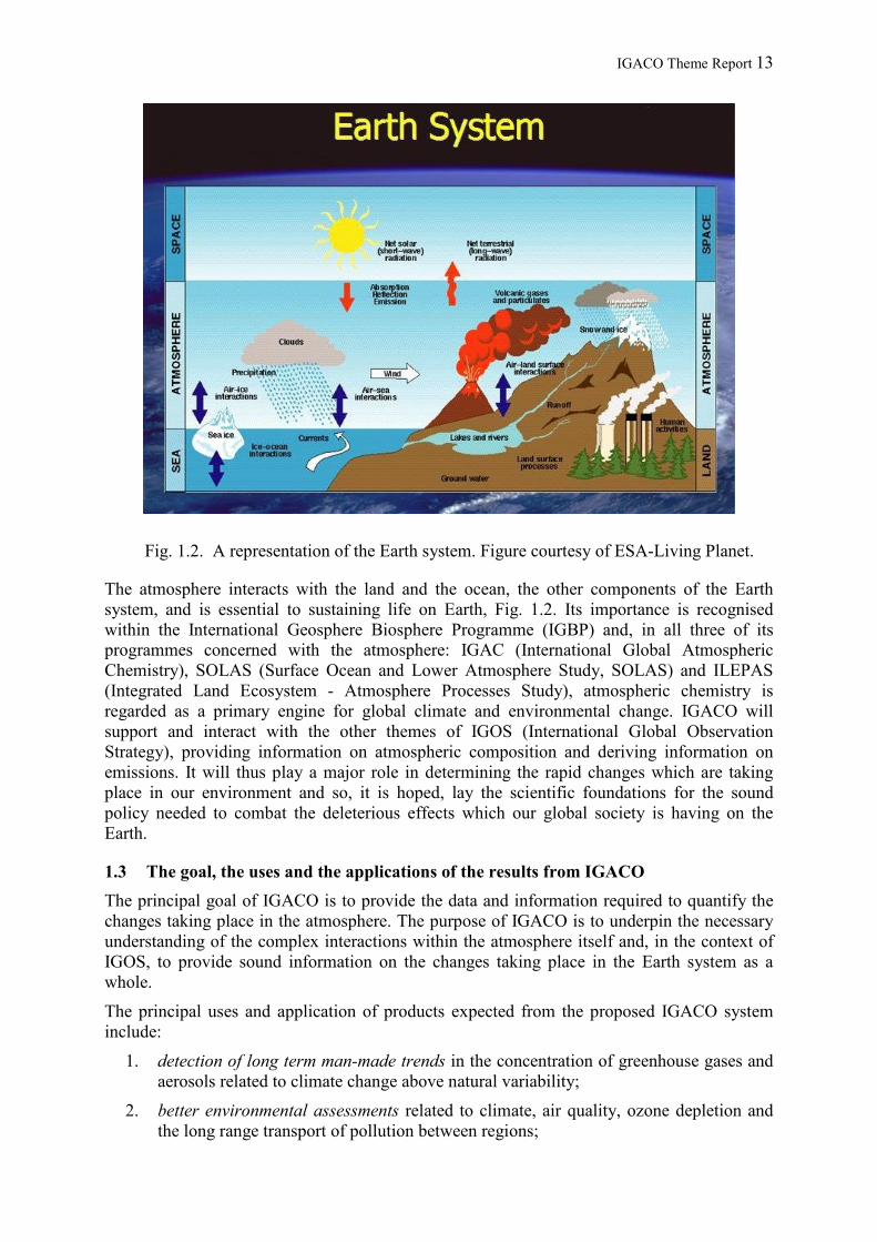
IGACO Theme Report 13
Fig. 1.2. A representation of the Earth system. Figure courtesy of ESA-Living Planet.
The atmosphere interacts with the land and the ocean, the other components of the Earth system, and is essential to sustaining life on Earth, Fig. 1.2. Its importance is recognised within the International Geosphere Biosphere Programme (IGBP) and, in all three of its programmes concerned with the atmosphere: IGAC (International Global Atmospheric Chemistry), SOLAS (Surface Ocean and Lower Atmosphere Study, SOLAS) and ILEPAS (Integrated Land Ecosystem - Atmosphere Processes Study), atmospheric chemistry is regarded as a primary engine for global climate and environmental change. IGACO will support and interact with the other themes of IGOS (International Global Observation Strategy), providing information on atmospheric composition and deriving information on emissions. It will thus play a major role in determining the rapid changes which are taking place in our environment and so, it is hoped, lay the scientific foundations for the sound policy needed to combat the deleterious effects which our global society is having on the Earth.
1.3 The goal, the uses and the applications of the results from IGACO The principal goal of IGACO is to provide the data and information required to quantify the changes taking place in the atmosphere. The purpose of IGACO is to underpin the necessary understanding of the complex interactions within the atmosphere itself and, in the context of IGOS, to provide sound information on the changes taking place in the Earth system as a whole.
The principal uses and application of products expected from the proposed IGACO system include:
1. detection of long term man-made trends in the concentration of greenhouse gases and aerosols related to climate change above natural variability;
2. better environmental assessments related to climate, air quality, ozone depletion and the long range transport of pollution between regions;

IGACO Theme Report 14
3. better quantification of pollution sources and their atmospheric pathways to sensitive downwind receptors;
4. reliable global concentrations fields of the selected chemical variables and aerosols at various altitudes for the study of outstanding problems in atmospheric chemistry;
5. better predictions of UV intensities at the Earth's surface both in populated and remote regions;
6. direct observation of plumes from major events such as forest fires, dust storms and volcanic eruptions; and
7. improved regional forecasts of both weather and air quality, and to provide forecasts in regions where these are unobtainable at the moment.
The reliable and detailed knowledge developed within IGACO will provide the basis of future regular scientific assessments of the state of the atmosphere and of the environment, and of global change.

IGACO Theme Report 15
2. The Grand Challenges in Atmospheric Chemistry Entering the 21st century, we are faced with an atmosphere which has changed and is continuing to change. Continued economic growth in the developed and developing world, and the much-needed growth required to alleviate poverty in the under-developed world, will ensure that the effects, particularly in the troposphere, will continue to increase and be of increasing concern for the foreseeable future. Although there appears to be a basic understanding of the major environmental problems, the details and the further effects, which will certainly reveal themselves as the atmosphere continues to change, require monitoring on a global scale.
In order to fulfil efficiently their requirements for protecting the atmosphere, new or revised conventions and protocols must be firmly based on a scientific system analysis, which requires a thorough understanding of how chemical emissions are processed in the atmosphere during transport over the land and sea. The major issues in atmospheric composition and chemistry, which manifest themselves in the problems listed in Table 1.1 are related to oxidising efficiency and air pollution in the troposphere, ozone depletion in the stratosphere and the coupling between atmospheric chemistry and climate change. The main objective of IGACO is to provide quantitative and representative information on these well recognised problems of man's influence on the atmosphere. However, the observing system should also provide the ability of recognising – if not predicting – new and hitherto unknown and potentially harmful developments.
The grand challenge of IGACO itself lies in the prediction of atmospheric chemical change, which is partly disguised by the natural variability of the atmosphere. The observed variability in the concentration of a compound is related to the spatial distribution of its sources and by its atmospheric turnover time, as determined by its bio- and geochemical sinks. The turnover times of atmospheric trace constituents span more than seven orders of magnitude, ranging from less than a second for the most reactive chemicals, such as the hydroxyl radical (OH) which determines the oxidation efficiency of the atmosphere, to several decades for N2O and CFCs, which are destroyed in the stratosphere. Temporal variability is intrinsically coupled to spatial inhomogeneity by atmospheric dynamics.
The architecture of an efficient integrated observing system must take account of the knowledge of the relevant scales for each compound. For example, it is practically impossible to obtain a representative and accurate estimate of the atmospheric oxidation efficiency by observing OH itself. A sufficiently accurate determination of trends in the concentrations of long-lived gases, such as CH4, N2O or CO2, on the other hand, can be obtained from a small number of well placed measurements. Identification of source regions and estimation of source strength for long lived compounds requires the capacity for detecting small concentration differences at global scale and with a spatial resolution that allows the resolution of political units and biotopes.
2.1 Air quality: the globalisation of air pollution As already indicated in section 1.1, the quality of air over populated areas is of continuing concern as the degradation of air quality has and will have a major impact on human health, agricultural productivity and natural ecosystems. The photochemical oxidation of hydrocarbons and CO in the presence of NOx is a major source of tropospheric ozone and other photo-oxidants on both regional and global scales. Abatement applied in several developed countries has reduced the emissions of the precursors, and there are also indications of a corresponding decrease in peak ozone levels. However the complicating influence of meteorological conditions still clouds the picture.

IGACO Theme Report 16
The quantitative understanding of the various sources of aerosols, their chemical composition as a function of size and their sources and sinks is still poor. The regional and inter-continental transport of aerosols, O3, CO and NO2 from biomass burning and from industrial pollutants in both the northern and southern hemispheres has been revealed by satellite and ground based observations.
While the emissions that cause these various effects are necessarily local, the consequences are regional and global due to atmospheric transport and the chemical processing which takes place during transport. As is highlighted in Fig. 2.1, a pollutant can be transported over country boundaries within a day or so and around the hemisphere within a week. The exchange between hemispheres is of the order of a year in the troposphere. There is growing evidence for a continued increase in the background of ozone in the troposphere, probably due to emissions from both developed and developing countries.
In order to improve existing abatement strategies for air quality laid down by the various international protocols and conventions, it is necessary to obtain information on the local versus regional or intercontinental influence on peak ozone levels, ozone exposure and particle distribution and on the background levels in the atmosphere.
IGACO will contribute to linking local and regional air pollution problems to the issue of global air quality by providing and maintaining the infrastructure for observations (surface observations, profile measurements, satellite data and ancillary meteorological data) that are integrated with a modelling system to produce comprehensive global atmospheric constituent fields. Of similar importance is the subsequent capability for local and national agencies to use these global fields to feed into their higher resolution air quality prediction models. The output from these models will, in turn, provide the decision support tools for regulatory enforcement.
From the larger scientific perspective, the upper troposphere and lower stratosphere is a particularly sensitive transition region where the chemical lifetime of ozone is relatively long while the meteorological transport time is short. The large variability in key trace gases and the small scales of important transport processes puts a greater demand on the capabilities of the observing system with regard to spatial and temporal resolution. Convection transports pollution from the surface into the upper troposphere, where chemical lifetimes are longer and transport much faster. However, ozone-rich air can also come from the stratosphere. It is presently still not possible to quantify reliably the role of changing surface emissions or the changes in stratosphere-troposphere exchange on the composition of the upper troposphere and hence on climate and air quality. The role of convection is poorly understood and not adequately treated in models. Observational data (cloud parameters for example) are needed that allow parameterisations to be tested. As new types of chemicals are released, there needs to be a process by which their impact on the global atmosphere can be evaluated. This approach should rest upon accurate observations and a solid scientific understanding of the atmospheric chemical processing system.
Requirement. Global modifications to atmospheric composition must be observed in order to monitor the influence of intercontinental transport on ozone and particles in terms of plumes (dust, ozone, CO, NOx) and with respect to a gradual change in the global background. High resolution measurements are required in the upper troposphere and lower stratosphere in order to distinguish the effects due to stratosphere/troposphere exchange and air transportation. On regional scales, some rationalisation of and a better coordination between the existing ground based networks (urban, regional and global) is important, including the

IGACO Theme Report 17
harmonisation of data archives and data quality. These must include the monitoring of relatively short lived reactive species (such as VOCs) and meteorological parameters. This requirement has been emphasised in several recent reports (see for example: US National Academy of Sciences, 2001).
2.2 Oxidising efficiency: the atmosphere as a waste processor The efficiency of the atmosphere to function as a general disposal system for most natural and anthropogenic emissions has been called into question. In order to maintain its self-cleaning capacity, the atmosphere needs a sufficient concentration of hydroxyl (OH) radicals and we do not know whether these concentrations are sustainable in the face of an ever-increasing burden of emissions, nor do we do know when such a limit will be reached.
Figure 2.2. A simplified scheme showing the interconnectedness in the chemistry of the troposphere. Re-worked by L. Barrie, WMO, after Guy Braseur.
A much-simplified diagram of the chemical troposphere, Fig. 2.2, illustrates the complexity and interconnectedness of the atmospheric processes. Photo-oxidation appears in the centre of the diagram; acidification on the right. The species shown in green are greenhouse gases.
Carbon compounds such as CO, CH4 and other hydrocarbons, together with NOx, O3, H2Oand UV radiation, regulate the distribution of the hydroxyl radical (OH). Hydrocarbons and CO deplete OH concentrations in the absence of NO but, on the other hand, enhance OH through catalytic chain reactions in the presence of nitrogen oxides. The strongly non-linear response of the radical balance to changes in chemical composition and UV radiation, and the relatively small spatial and temporal scales at which NOx and the more reactive VOCs are removed from the atmosphere, represents a real challenge for atmospheric chemistry transport models, if they are to predict accurately the global atmospheric OH field and its response to changing emissions and climate. There are still large uncertainties in the emissions of carbon compounds and NOx. These concern, in particular, natural emissions from wetlands, vegetation, soils, and forest fires, anthropogenic biomass burning and the NOx production

IGACO Theme Report 18
from lightning. The potential importance of oxygenated organic compounds as sources of free radicals to the upper troposphere was shown only recently. High water vapour concentrations and high UV-B levels favour the formation of OH in the boundary layer. However, this may be counteracted by low O3 and NO concentrations in some regions. Recent research has also shown that halogen radicals may also be playing a small but significant role in the oxidising efficiency of the troposphere. Similarly the nitrate radical, which results in large part from anthropogenic NOx emissions, can have significant local importance at night.
Changes in the oxidation efficiency are linked to climate and stratospheric O3 through changes in temperature, water vapour, and UV radiation, as well as lightning, rainfall patterns and changes in atmospheric circulation. Because of the very short lifetimes of OH and the other radicals, the oxidation efficiency of the atmosphere can only be monitored indirectly.
Requirement: Detailed monitoring of the key parameters (NO, H2O, UV-B, NO2, O3, CO, CH4 and other VOCs) that control the concentration of OH on a global scale is required. The emphasis must be on global coverage including remote areas. Particular emphasis must be on the tropics, where most of the oxidation takes place for the longer lived gases, such as CH4and CO. Because of the non linear nature of the chemical system, vertical profile information between the surface and the tropopause for UV and the short lived gases is essential for the calculation of the OH concentration. This is currently not possible with existing satellites. The suggestion is therefore to assimilate the tropospheric column information from satellites with local fields from surface networks and aircraft measurements in chemistry-transport models with appropriate chemistry schemes for calculating OH, or to monitor selected trace gases that are removed by reaction with OH and whose sources are accurately enough known.
2.3 The stratospheric ozone shield One of the lessons taught by stratospheric ozone depletion is that trace amounts of relatively benign chemical compounds can have a large impact on atmospheric chemistry. The ozone hole further demonstrated that the system can spring unpleasant surprises: ozone depletion at the time was thought to be well understood and the understanding had to be modified to encompass chemical processes and meteorological processes that had hardly been considered before. And while controls on chlorofluorocarbons appear to have stabilised the polar ozone loss, and current models predict that the polar ozone holes will gradually decrease in intensity and duration, it would be foolhardy to believe that the global atmospheric system is incapable of further surprises.
Chemically, the stratosphere as a whole and the ozone layer in particular has undergone major changes within the last half century. Some of these are anthropogenic in origin and are relatively well understood; for others, explanations are still required, despite their unmistakable signal. Anthropogenic chlorine is the primary culprit leading to the thinning of the ozone layer, especially at polar latitudes. However, the frequency of measurements deep in the Arctic vortex remains low. The situation is unsatisfactory given the highly non-linear sensitivity of Arctic stratospheric ozone to cold winters. Over the last two decades in mid-latitudes an average decrease of total ozone of 4% has been found in the northern hemisphere and 6% in the southern. Chemical and dynamical perturbations caused by strong volcanic eruptions make it impossible to derive a linear trend, which highlights the importance of continuous measurements throughout the expected recovery of the ozone layer during the coming decades.
UV irradiance has increased since the early 1980s by 6 to 14% at more than ten sites distributed over the mid and high latitudes of both hemispheres, in agreement with estimates from satellite measurements. The high spatial and temporal variability of the predominant variables affecting ultraviolet radiation at the Earth’s surface and throughout the troposphere

IGACO Theme Report 19
(clouds, aerosols, snow/ice cover, total ozone) continue to impede the quantification of surface UV radiation on the global scale. Accurate long-term high-coverage data are required to obtain reliable estimates of the global UV trend.
Continued monitoring of stratospheric chlorine and bromine are essential to assess the recovery of stratospheric ozone levels to natural levels. However, shorter-lived ozone depleting substances might have a significant effect on stratospheric ozone when emitted in the tropics where deep convection may transport these substances rapidly into the lower stratosphere. Estimates of ozone depletion potentials are currently uncertain because of the lack of data on the products of the tropospheric degradation, and also for tropical emissions.
Reactive nitrogen compounds (NOy) are now attracting attention. Observations and modelling results show that a massive de-nitrification (removal of up to 70% of NOy) in the Arctic lower stratosphere in the 1999-2000 increased ozone loss by as much as 30% at 20 km in the spring. The origin of lower stratospheric NOy needs to be better understood. It has been known that some is transported from above, and that it is produced in situ at high altitudes by lightning and air traffic. However, there are now also indications that NOy may be transported into the lower stratosphere from the tropical tropopause region by quasi-horizontal, isentropic transport following deep convection from the polluted mid-latitude boundary layer. These recent observations point to the need to measure stratospheric and upper tropospheric NOxand NOy both locally and globally.
Stratospheric humidity also seems to have increased appreciably during the last five decades. An increase in water vapour of on the average 1 % per year is estimated to have led to roughly a doubling in stratospheric water vapour over altitudes between 15 and 28 km. Global satellite measurements covering latitudes 60°N – 60°S show a similar trend of 0.6-0.8% per year for altitudes above 25 km, but no significant trend at lower altitudes. The increases in water vapour are substantially larger than can be explained by tropospheric CH4 trends. Characterisation of stratospheric water vapour trends remains limited by the lack of global long-term measurements.
A long term stratospheric record of global aerosol coverage has been established from a diverse system of largely uncoordinated ground-based observations covering over two decades and documenting the effect of volcanic eruptions. These observations are augmented by extensive satellite measurements. However, the issue of whether the background level has ever been reached after volcanic eruptions and whether the known sulfur-containing trace gases are sufficient to account fully for the background level require more comprehensive long term observations. We require a detailed understanding of the space and time distribution of aerosols, for which no systematic measurement system yet exists.
Thanks to decreasing temperatures and increasing water vapour there is a possibility of increased occurrence of polar stratospheric clouds (PSC) in the Arctic stratosphere. A comprehensive measurement system should include PSCs as synoptic variable combining lidar observations from the ground and nadir-looking thermal imagery from space.
Current global ground-based observational networks for total column and vertical profiles operated by the WMO Global Atmosphere Watch (GAW) and the Network for Detection of Stratospheric Change (NDSC) have a long history of comprehensive quality observations. However, gaps exist in measurement methodology, network coverage, data archiving and analysis, and these are discussed further in chapter 4. Sufficient satellite-observation capabilities are available until the end of the lifetime of ENVISAT and EOS-Aura. Continuation of such measurements beyond that time frame is needed for successful monitoring of the recovery of the ozone, and for confirmation of the trend of increasing H2O.

IGACO Theme Report 20
Requirement. Measurements of vertical profiles are needed for O3, water vapour, NOx,HNO3, halogen sources, active halogens and their reservoirs, as well as aerosol properties and methane (CH4) (the last as a tracer and for investigation of the H2O budget), together with temperature and ancillary parameters.
2.4 Coupling between atmospheric chemistry and climate The interaction between atmospheric chemistry and climate is one of the most intriguing and important branches of atmospheric research, which scientists are only just beginning to explore. The atmospheric chemistry is driven primarily by the energy of the incoming solar UV radiation, generating atoms and free radicals which initiate catalytic reactions. These reactions are dependent on temperature and transport and hence upon climate. The climate itself depends on the energy input, from greenhouse gases with strong absorption bands in the mid-infrared, which determines the outgoing part of the radiation energy balance of the atmosphere. The distributions and concentrations of greenhouse gases are in turn influenced by atmospheric chemistry.
Figure 2.4. Interactions between climate, atmospheric composition, chemical and physical processes and human activities (after Isaksen, 2003).
A number of trace gases produced by human activities add to both the greenhouse effect and to the chemical activity and burden, Fig. 2.4. Ozone plays multiple climate forcing roles, through the absorption of solar ultra-violet radiation and terrestrial infrared radiation. Changes in CH4 concentration affect climate and the O3 distribution in the troposphere and in the stratosphere. Aerosols, both natural and anthropogenic, are another important component in the climate system. Tropospheric aerosols produce a direct radiative forcing by virtue of scattering and absorbing solar radiation, and an indirect forcing by changing the radiative properties of clouds. The exact magnitude of the total aerosol forcing, especially the forcing due to black carbon, remains one of the largest unknown factors in climate research.
Evidence is now emerging of the feedbacks between chemistry and climate. The increase in the abundance of greenhouse gases and ozone loss result in lower stratospheric temperatures. Low stratospheric temperatures permit the formation of cloud and aerosol particles, which have implications for both atmospheric chemistry and radiation. Understanding the conditions under which these particles form is important if accurate estimates are to be made for an atmosphere with altered temperature distributions.

IGACO Theme Report 21
It is to be expected that changes in the temperature distribution of the stratosphere will alter the stratospheric circulation and dynamics. These in turn are coupled to the tropospheric circulation and so to the tropospheric temperature distribution and climate.
Climate change may induce changes in the dynamics of the tropopause region which affect the transport of water vapour and other trace gases from the troposphere into the stratosphere, and thus affect aerosol formation, chemistry, and radiation in the stratosphere. Understanding how stratospheric water vapour might change in the future requires basic understanding of the dynamics of the tropopause region and troposphere-stratosphere exchange mechanisms.
The downward transport of stratospheric ozone has a major effect on the upper troposphere ozone concentration; in a warmer climate, such transport is expected to increase and hence influence tropospheric chemistry.
The Brewer-Dobson circulation transports tropical air to higher latitudes and influences the composition of the mid and high latitude atmosphere. The circulation also affects the structure and temperature of the polar vortex by increasing the temperature of the polar vortex and hence affecting polar ozone chemistry. Models predict that in a warmer climate the Brewer-Dobson circulation will be stronger and will affect the composition of both the stratosphere and troposphere.
A variety of chemistry/climate models are being developed to describe and understand the interactions and their implications. The task is challenging because of the time and spatial scales that must be encompassed; from chemical reactions occurring in microseconds to the development of the atmosphere over decades and from meters to ten thousands of kilometres. Moreover both chemistry and climate are nonlinear and separation of the natural variability of the coupled system and the anthropogenic induced changes is far from trivial.
Understanding the coupling between climate and chemistry is a grand challenge for the next decades, requiring large efforts both from the observational side and from the modelling.
Requirements. a) The integrated global observation system for climate-chemistry interaction requires sustained and long-term measurement of the distribution and sources and sinks of greenhouse gases (H2O, CO2, CH4, O3, N2O) and related gases (CO, NOx, NMHC), aerosols (optical properties and size parameter) and meteorological variables such as winds, temperature and clouds with appropriate vertical resolution, temporal resolution and global representativeness. b) Chemistry climate models should be further developed and validated by comparison with these 4-D datasets for atmospheric composition, meteorology and climate. It should be understood that comprehensive long-term measurements using all the facilities available are essential if the chemistry/climate interaction is to be unravelled.

IGACO Theme Report 22
3. The Existing Atmospheric Observation System The global long-term observational system for atmospheric composition comprises four components:
• routine ground-based measurements including in situ, remote sensing and balloon instrumentation;
• systematic aircraft measurements;
• satellite measurements with instrumentation viewing in nadir and limb directions; and
• a data modelling system with assimilation to provide a comprehensive global picture.
The three measurement components having different strengths and weaknesses complement each other.
3.1 Ground-based instrumentation The last 50 years has seen a revolution in the development of in situ techniques for the measurement of atmospheric trace constituents.
Current ground-based networks involve a number of different instrument types:
• measurement instruments operating in modes ranging from continuous to periodic sampling;
• balloon sondes profiling tropospheric and stratospheric concentrations of O3 and water vapour;
• passive remote sensing spectrometers operating in various wavelength regions providing total column or low resolution vertical profiles of a number of atmospheric gases and aerosols; and
• active remote sensing lidar instruments for high resolution remote sensing of atmospheric components.
A variety of sophisticated measurement techniques are used such as emission and absorption spectroscopy, gas chromatography with electron capture, flame ionisation or mass spectrometric detectors, chemical ionisation mass spectrometry and chemiluminescence.
The current role of globally distributed ground stations is to provide high quality observations for:
• detecting long term trends in atmospheric concentrations;
• monitoring air quality on a regional to global scale;
• understanding the long range transport pathways of pollution;
• evaluating and developing regional to global scale models that include atmospheric chemicals (e.g. local and regional weather and air quality forecast models, long range transport models and climate models); and
• calibration and validation of satellite observations.
The WMO GAW programme coordinates global ground-based networks measuring greenhouse gases, ozone, UV radiation, aerosols and selected reactive gases. GAW also combines the considerable monitoring activities conducted by member countries with those of global partners such as the Network for Detection of Stratospheric Change (NDSC), NASA

IGACO Theme Report 23
SHADOZ, NASA AERONET, and regional networks such as EMEP, EANET and CAPMoN in order to extend coverage offered for these classes of compounds. The activities since the start with O3 in 1957 have included the establishment of the WMO member-supported GAW measurement stations, the Central Calibration Laboratories, the Quality Assurance/Science Activity Centres, World Calibration Centres and the five World Data Centres facilities, all under the guidance of scientific advisory groups of internationally recognised experts. However, despite the best efforts, global observations often lack inter-calibration and data harmonisation. Two examples of global ground based networks maintained through such partnerships are shown in Fig. 3.1.
Figure 3.1. Maps of two global ground-based networks for balloon vertical profiling of ozone and carbon dioxide The networks are collaborations involving WMO members and partners Kindly provided by the GAW World Data Centres for Ozone and the UV, and for Greenhouse Gases).
3.2 Airborne instrumentation Aircraft have been used for many years to probe the free troposphere and lower stratosphere on a research basis. The first attempt to utilise commercial aircraft for regular atmospheric observations was the NASA Global Atmospheric Sampling Programme (GASP) in the 1970s. After GASP had been terminated in 1979, the idea was reactivated in the 1990s. In the European programme MOZAIC, automatic instruments for O3 and H2O (plus CO and NO/NOy in 2001) were installed on several commercial aircraft in 1994 and have, since then, provided regular data for the upper troposphere/lower stratosphere (UT/LS) with more than 2000 flights and 4000 tropospheric profiles per year.
Other projects with commercial aircraft include grab sampling packages, flown biweekly, since 1993 between Australia and Japan to provide CO2, CH4 and CO data at cruise altitude. The Swiss NOXAR project provided the first regular NOx data with 500 flights between 1995 and 1996. In CARIBIC, an air freight container with in situ instruments for O3, CO, and aerosol measurements and grab samples for VOCs, CFCs, N2O and isotopic analysis was deployed during 83 flights between 1997 and 2002. Fig. 3.2 shows a map of the routes covered by different programmes.

IGACO Theme Report 24
Figure 3.2. Flight routes of MOZAIC (21000 flights 1994-2003, yellow), JAL (ca 1000 flights 1993-2003, purple), NOXAR (622 flights, blue), and CARIBIC (83 flights 1997-2001, green). Kindly supplied by Andreas Volz-Thomas, Jülich.
Routine aircraft measurements are currently the most efficient tool for obtaining representative information on the UT/LS and vertical profiles in the troposphere at high resolution and with uniform quality. However, as most ongoing projects are funded under short term research contracts, they are in continuous danger of being terminated. Continuation is secure for the Japanese grab sampling programme until 2017 and until 2014 for CARIBIC which will start operation with an enhanced measurement suite (O3, H2O, CO, NO, NO2,NOy, HCHO, aerosol size and composition, BrO, halocarbons, VOCs, CH4, CO2, Hg, and O2)in 2004 with 1 to 2 flights per month. These measurements are valuable for IGACO but cannot provide a truly global picture of the free troposphere and UT/LS. An extension of the MOZAIC-type measurements with many flights per day and extension of the global coverage is urgently needed.
There are also a few initiatives for using small aircraft on a regular basis. Examples are the NOAA/CMDL initiative for collecting vertical profiles of CO2 and CH4, several times per week at a number of sites around the world, the RIALTO initiative of the Canadian Environment service for making regular measurements of O3 and possibly NO2, HCHO, SO2,BrO by MAXDOAS (multi axial DOAS) in the lower troposphere on regular flights of the Canadian coastal guard, and a few pilot programmes that perform aerosol scattering and aerosol absorption profiling on a routine basis.
3.3 Satellite instrumentation Compared to point measurements made by ground-based sensors and one-dimensional routes followed by airborne instrumentation, the advantage of space-borne sensors is their global three-dimensional coverage and regular repeat cycle. Traditionally data-sparse regions above the oceans, polar zones and developing countries are observed with the same uniform data quality as the industrialised countries. Space data are the natural feed for global atmospheric models.
The first satellite measurements of atmospheric trace gases and aerosols focused primarily on the investigation of stratospheric ozone depletion. At these altitudes, observations in both nadir and limb viewing geometry are not adversely affected by clouds. Stratospheric profile information can best be acquired by viewing in limb geometry. Nadir-viewing instruments provide total column measurements, but some vertical resolution can also be achieved if the

IGACO Theme Report 25
response function of the species being measured exhibits an altitude dependence. Research satellites, such as UARS, ENVISAT, AURA, have contributed strongly, and will contribute further, to stratospheric chemistry science. Long-term records have been obtained for total column / low vertical resolution ozone (TOMS, GOME), high resolution stratospheric ozone profiles (SAGE) and a limited set of other species. The transition to operational monitoring has been initiated for low resolution ozone and some other total column products obtained from nadir-viewing instruments on NPOESS and METOP. There is not yet any provision for a system covering high resolution stratospheric profiles of ozone and other constituents, such as aerosol and active and reservoir species of the nitrogen and halogen families.
High resolution profiling of the UT/LS region is essential for monitoring climate - chemistry interactions, and stratosphere – troposphere exchange, and supports the interpretation of total column information from nadir sounders and the assessment of global pollution issues. A first step in this direction will be made by the exploitation of current research satellite data (ENVISAT, AURA), but with limitations on vertical resolution, global coverage, and the ability to screen clouds. A long-term monitoring system is yet to be put in place.
Monitoring of the tropospheric composition is needed for climate and air quality applications and for the assessment of the oxidising efficiency of the atmosphere. The mid and lower troposphere is difficult to access with limb-sounding, due to the opacity of the atmospheric layers above and the high sensitivity of this viewing geometry to cloud and aerosol contamination. Nowadays, information on the troposphere is extracted from nadir pointing instruments that were primarily designed for the stratosphere (e.g. GOME). Some impressive results have been obtained by exploiting, for example, temperature-induced altitude dependences in the spectral signatures of trace gases. Products include ozone profiles with 2 to 3 tropospheric pieces of information and tropospheric column data for species whose stratospheric abundance is either low or can be estimated with models. As an example, Fig. 3.3 shows a global map of the tropospheric column of NO2 which is of high importance for air quality and oxidising efficiency. However, for tropospheric applications, the existing instruments suffer from several severe limitations which must be eliminated in the next generation of sensors.
• The horizontal resolution is too low for detailed assessments and local predictions of air pollution; and the pixel size is too large, leading to a loss of much of the data due to cloud contamination.
• Vertical resolution is a persistent challenge for tropospheric measurements from space. To date, no concerted effort has been made to combine all means to obtain more than total columns, such as
o co-registered measurements of nadir-viewing UV–visible–near infrared instruments delivering total column data with mid-infrared high resolution spectrometers providing some height information from the mid-troposphere upwards;
o combination of nadir- and limb-viewing observations, in order to obtain lower/mid tropospheric columns by subtraction of the integrated upper tropospheric and stratospheric limb-sounder profiles from the total columns obtained with nadir sounders;
o high spectral resolution near-infrared observations with full global coverage to obtain detailed information on climate gases and aerosol.
• The temporal sampling of the existing systems is too low to capture the pronounced diurnal variations in particular in the boundary layer.

IGACO Theme Report 26
Figure 3.3. Global NO2. A six year average of observations taken in the narrow swath mode. The industrial sources are clearly visible. Image kindly supplied by Steffen Beirle and Thomas Wagner, IUP, Heidelberg.
The choice of the orbit depends on the specific data requirements. High vertical resolution profiles – only possible in the stratosphere and upper troposphere – are obtained using the limb-sounding technique which requires a low earth orbit (LEO). All present satellites are in LEO, typically at 800 km, most of them sun synchronous; i.e. the satellite passes over the same location at the same local time. The repeat cycle depends on the spatial sampling, but daily repeat cycles are routinely achieved globally with a single satellite; two satellites could provide a twelve-hour time sampling.
To obtain the time resolution necessary to encompass variations in tropospheric constituents, the geostationary orbit (GEO) (at ca 36000 km) is another option. The long distance requires the use of larger telescopes but the continued observation of a given area by a single pixel (the exception being polar regions), allows the use of integration to recover a satisfactory signal to noise ratio while still achieving a time resolution of the order of an hour. Thus, diurnal variations resulting from both chemical transformations and regional transport are readily observed. Meteorological satellites have successfully exploited this orbit for tropospheric measurements of clouds and other parameters required for weather prediction. Three to four GEOs would be required to for global coverage. An alternative would be several LEO polar orbiting satellites, their number depending on the required time resolution and the orbit height. The trade-off between the two options is determined by temporal resolution, coverage required, signal-to-noise ratio, size and stability of footprint, and by technical and cost considerations.
One point, worth emphasising however when considering space observations, is that to realise its potential; a space-based system requires an ongoing ground-based calibration measurement system. In the past, this requirement has not been included in satellite missions.
3.4 Modelling and data assimilation Modelling and data assimilation, bring together the host of measurements to provide optimal temporal and spatial reconstructions of key atmospheric constituents. Such a synthesis yields invaluable information on the consistency and the quality of measurements so that trends, variability and sources and sinks of these species can be quantified. In turn, improved models will be developed to provide better predictions as well as a better reconstruction of past changes. Eventually, it is envisaged that the synthesis of information will be used by operational agencies, policy makers and the general public as part of a decision-support system.

IGACO Theme Report 27
CTM Models. The basic tool in an Integrated Observation System is a chemical transport model (CTM). Such models are based on the physics of fluid dynamics and transport, input from an emissions module to provide data on man-made and natural biosphere emissions, and a chemical module, which may include hundreds of species and chemical reactions. More complex processes involving aerosols, liquid processes in cloud droplets, and reactions on the surface of solid particles, are usually treated through parameterisation. Such models of the atmospheric dynamics and chemistry have the ability to calculate missing and under-sampled parameters and to generate continuous and self-consistent fields of atmospheric trace constituents.
CCM Models. Long-term descriptions of the atmosphere can be obtained with chemistry-climate models (CCM), where the evolution of atmospheric composition and climate is modelled simultaneously and interactively, taking account the feedbacks between chemistry and climate. Present models are reasonably successful, although there are weaknesses in the parameterisations, the emission scenarios assumed, and the chemical mechanisms employed. There is an inherent problem of averaging - using values within a model grid box, which markedly vary within the dimension of the box. This problem is equivalent to the problem of the representativeness of a particular measuring station for a model grid square, and indeed the representativeness of a satellite column measurement for the average concentration.
Data assimilation. An integrated observation system will combine the information contained in the measurements and the theoretical model by means of a data assimilation scheme in order to generate data of improved quality. The heritage of data assimilation is the development of weather forecasting models which minimise the difference between model evolution and measurements. An essential element in the scheme is the quantification of errors that may originate from either measurement or model; the gain in information content is continually assessed. The output will be the best available knowledge of the state of the atmosphere; it must be validated by independent measurements.
Assimilation of satellite measurements of chemical species, notably stratospheric ozone, into an operational weather forecast system is a relatively recent development. It has been used in numerical weather prediction to improve significantly the assimilation of satellite radiances. It has been successfully applied to forecast the evolution of the ozone hole and to forecast the UV exposure of the earth surface. The daily UV forecasts delivered by many meteorological organisations form a visible demonstration of this technique for the general public.
New challenges in data assimilation and CTM model development are posed by the inverse modelling of emissions. An important application is the improvement of the greenhouse gas emission inventories derived from atmospheric concentration distributions. The successful application of this technique had been limited by the sparse data available from ground based stations. With the advent of space-based measurements much better global coverage can be reached. However, the improvement of the accuracy of space-based measurements and how such remote observations relate to observed boundary layer and surface observations remain critical scientific challenges.
Air quality forecasting. An important application of an integrated observation system is the generation of an air pollution forecast or a chemical weather forecast. Such forecasts would be useful for Environmental Agencies and the general public as potential decision-support tools, which can be used to implement regulatory actions on emissions from sources such as vehicular traffic and electric power generation, and to provide health warnings for polluted areas. An example of a forecast system using mainly satellite data is shown in Fig. 3.4.

IGACO Theme Report 28
Fig. 3.4. An example of regional air quality forecast system based, in this case, mainly on satellite measurements. Figure kindly supplied by Jack Fishman, NASA.
Utilisation of air quality forecast models requires near-real-time chemical data acquisition, typically within three to six hours. For rapidly varying species, sampling must be frequent enough to capture these variations. For example, species that exhibit significant diurnal variation require measurements at sub-daily and, ideally, hourly intervals. Building an operational system for chemical weather-forecasting imposes challenging requirements on the quality and consistency of the input data, the quality and reliability of the data generation and distribution, as well as the long-term continuity prospect of the entire system.

IGACO Theme Report 29
4. Atmospheric Chemical Observations for Targeted Parameters
4.1 Introduction The problems in atmospheric chemistry have been simplified in section 2.1into four issues:
• tropospheric air quality;
• the oxidation efficiency of the atmosphere;
• stratospheric chemistry and ozone depletion; and
• chemistry climate interactions.
It is possible to study and monitor these issues by observing a number of chemical compounds, aerosol properties and other parameters. A list of these variables and chemical species, and the issues in which they are involved is given in Table 4.1. They were chosen on the basis of the following criteria :
a. the chemical species or variable plays an important role in one or more of the four key atmospheric chemistry issues and there is added value in its incorporation in an integrated global observation system;
b. it is now possible, or likely to be possible, to measure the atmospheric constituent or parameter globally and on a long term so as to achieve a synergism between satellite ground-based and aircraft observations, and model assimilation systems.
The list in Table 4.1, chosen on the grounds of likely feasibility, is far from exhaustive. There are many other desirable variables such as precipitation chemistry and aerosol composition, some of which are already being addressed in the ground-based networks. More detailed information on the choices and on the present and likely future state of the measurements is given below.
4.2 Specific chemical species and other parameters In this section, the state of the observational system for most compounds is portrayed as a timeline diagram. Each diagram summarises the past and future state of satellite observations, non-satellite observations and status of assimilation (i.e. smart interpolation) of global chemical transport models based on forecast/climate models. The shading of the timelines indicates a best estimate of how well a particular measurement provides quality global coverage.
For non-satellite measurements, demonstration mode means that there is an incomplete network of measurements that are not archived or publicly available through a data centre; pre-operational mode means that an approximation of a global network is available but the observations do not yet fully meet quality assurance and inter-network comparability requirements; operational mode means that a global network exists in which data is of high quality and available from a central archive.
Ozone: O3
O3 is a key atmospheric constituent in all four air chemistry issues. In air quality, atmospheric boundary layer ozone is of concern for human health and for damage to vegetation, and many environmental agencies set regulatory standards to minimise the effects on human health and vegetation. In the boundary layer, O3 is produced by the photochemical oxidation of VOCs in the presence of NOx and sunlight; it adds to O3 transported down from the stratosphere to the middle troposphere. For the oxidising efficiency of the troposphere, ozone plays a role as an indicator of photochemical production, similar to that occurring in the boundary layer close to

IGACO Theme Report 30
sources. As an oxidant, it converts SO2 to sulfate aerosols in clouds; it is the primary source of OH radicals: when photolysed it produces O (1D) which reacts with water vapour to form OH. For climate, O3 in the middle to upper troposphere is an important greenhouse gas. In the stratosphere, it acts as an absorber of ultraviolet solar radiation, providing a UV shield for the Earth, as well as an energy source. The shield is however vulnerable to catalytic destruction of O3 by halogen compounds such as CFCs.
Table 4.1. Key atmospheric chemical species and the relevant environmental issues. The table gives a list of the atmospheric constituents to be targeted in IGACO together with an indication of their importance to the four atmospheric challenges. Also included are aerosol optical properties – a broad categorisation which encompasses the scattering and absorption of solar radiation by particles of all sizes.
Chemical species
air quality oxidation efficiency
climate Stratospheric ozone depletion
O3 � � � �
CO � � - -
j(NO2) � � - -
j(O1D) � � - -
H2O (water vapour) � � � �
HCHO � � - -
VOCs � � - -
active nitrogen: NOx = NO+NO2reservoir species: HNO3
��
��
--
��
N2O - - � �
SO2 � - � -
active halogens: BrO, ClO, OClO reservoir species: HCl, ClONO2sources: CH3Br, CFC-12, HCFC-22
---
---
---
���
aerosol optical properties � - � �
CO2 - - � -
CH4 - � � �
Critical Ancillary Parameters
temperature � � � �
pressure � � � �
wind speed (u,v,w) � � � �
cloud top height � � � �
cloud coverage � � � �
albedo � � � �
lightning flash frequency � � � �
fires � � � -
solar radiation � � � �

IGACO Theme Report 31
An Overview of satellite, ground-based and aircraft measurements for tropospheric O3
COMPONENT 90 91 92 93 94 95 96 97 98 99 2000 1 2 3 4 5 6 7 8 9 10 11 12 13 14 15 16 17 18 19 20Non-Satellite GlobalSurface in situ B B B B B B B B B B B B B B B B B B B B B B B B B B B B B B BSuface based Lidar profileBalloon vertical profile
Aircraft P, UTMOSAICNOXARCARIBIC UT/LSNOAA CMDL
SatelliteIndirect-Subtract Statosphere TOMS C,PAURA OMI 04 C,P
SatelliteDirect Upper TroposphericSAGE II & III UT PERS GOME-1 95 C,PMETOP 1,2,3 GOME2 05 C,PNPP OMPS 06 C,PNPOESS OMPS 10 C,P B B B B B B B B B B BSCISAT ACE 03 PSCISAT MAESTRO 04 P
Direct MeasurementENVISAT SCIAMACHY 02 C,PAURA TES 04 C,P
Measurement 90 91 92 93 94 95 96 97 98 99 2000 1 2 3 4 5 6 7 8 9 10 11 12 13 14 15 16 17 18 19 20
DEMONSTRATION UT/LS: upper trop./lower strat.PRE-OPERATIONAL Data available in near real time C=column T=troposphereOPERATIONAL B Data available in near real time and replacement guaranteed by agency P=profile S=stratospherePROPOSED
Figure 4.2.1. A timeline diagram for tropospheric O3.
Here, because of differences in scale and observational techniques, timelines are shown for O3in the troposphere and in the stratosphere. It must however be emphasised that the interface between these two atmospheric regions the upper troposphere and the lower stratosphere (UT/LS) is of much importance in atmospheric transport and cannot be neglected in planning the IGACO system.
An Overview of satellite, ground-based and aircraft measurements for stratospheric O3
COMPONENT 90 91 92 93 94 95 96 97 98 99 2000 1 2 3 4 5 6 7 8 9 10 11 12 13 14 15 16 17 18 19 20
Non-Satellite GlobalSurface total column Dobson C, P B B B B B B B B B B B B B B B B B B B B B B B B B B B B B B BSurface total column Brewer C, P B B B B B B B B B B B B B B B B B B B B B B B B B B B B B B BSurfacebased vertical profile Microwave PSuface based Lidar profile PBalloon vertical profile P B B B B B B B B B B B B B B B B B B B B B B B B B B B B B B B
AircraftMOZAIC LSNOXAR LSCARIBIC UT/LS
SatelliteNIMBUS7/TOMS 79 CERBS SAGEII 84 PUARS MLS 91 PUARS HALOE 91 PUARS CLAES 91 PMETEOR TOMS 92 CERS GOME-1 95 C, PADEOS TOMS 96 CADEOS ILAS 96 PEP TOMS 96 CENVISAT MIPAS 02 PENVISAT GOMOS 02 PENVISAT SCIAMACHY 02 C, PMETEOR3M SAGE III 02 PAQUA AIRS 02 CADEOS 2 ILAS2 03 P cAURA HRLDS 04 PAURA MLS 04 PAURA OMI 04 C, PAURA TES 04 C, PMETOP 1,2,3 GOME2 05 C, PMETOP IASI 05 CNOAA HIRS C B B B B B B B B B B B B B B B B B B B B B BNPOESS OMPS 10 C, P B B B B B B B B B B BNPP OMPS 06 C, PSCISAT ACE 03 PSCISAT MAESTRO 04 P
Measurement 90 91 92 93 94 95 96 97 98 99 2000 1 2 3 4 5 6 7 8 9 10 11 12 13 14 15 16 17 18 19 20
DEMONSTRATION UT/LS: upper trop./lower strat.PRE-OPERATIONAL Data available in near real time C=column T=troposphereOPERATIONAL B Data available in near real time and replacement guaranteed by agency P=profile S=stratospherePROPOSED
Figure 4.2.2. A timeline diagram for stratospheric O3.

IGACO Theme Report 32
The timelines show that there are numerous satellite stratospheric O3 measurements of demonstration quality up until 2010. After 2010, two operational quality LEO satellites are available for global ozone characterization.
There are operational ground based networks for vertical profiles and total column O3operated by GAW. Stratospheric ozone vertical profiles (see Fig. 3.1) are obtained from the global balloon sonde network maintained by GAW and its contributing partners NASA/SHADOZ and NDSC. It is operational but needs considerable effort to fill gaps in coverage and to complete the establishment of a formal measurement protocol and quality assurance programme. The GAW total column network as indicated by those submitting data is shown in Fig. 4.2.3. Today global coverage is attained through measurements by three instrument types: the Dobson and Brewer spectrophotometers and the Russian filter instrument.
GAW is building a systematic programme of routine calibration of instruments linking them to a global standard reference instruments maintained by WMO members and collecting observations at the World Ozone and UV Data Centre in Toronto. There is a need to replace the Russian filter instruments with the more accurate Dobson or Brewer and to encourage those stations that are not submitting data to do so. This would greatly enhance the network in many regions showing gaps on Fig. 4.2.3.
Figure 4.2.3. Global Column Ozone Network, 2003. Kindly provided by the WMO/GAW World Ozone and UV Data Centre, Toronto.
Systematic ground based observations of in situ ozone are made at 37 GAW global and regional stations. They are linked to a global standard at NIST in Washington and quality assured by the GAW World Calibration Centre for in situ ozone in Zurich, Switzerland. The data are archived at the World Data Centre for Greenhouse Gases in Japan. There is much work to be done with partners to collect a global data set. Many environmental agencies support ozone measurements at regionally representative sites. This is one gap that needs to be filled by IGACO.
Systematic measurements of in situ O3 from commercial aircraft are now available for selected routes from Europe through the MOZAIC and CARIBIC programmes, section 3.2. NOAA/CMDL is beginning a programme of routine vertical profiling of the lower troposphere at a large number of locations using light aircraft. Aircraft observations are in the

IGACO Theme Report 33
demonstration stage because coverage is not comprehensive, vertical profiles are limited and the data are not yet freely available. Expansion of these observations is needed.
Atmospheric forecast models that include stratospheric ozone are currently assimilating non-satellite and satellite observations to produce UV forecasts. They are in demonstration mode and moving into pre-operational mode as more data become available in real time. These same models can be used in a re-analysis of all observations (real time and non-real time) as the integrated observational system improves and delivers more data to a central archive.
Carbon monoxide: CO CO is a reactive gas that displays a strong temporal and spatial variation. Its origin is predominantly anthropogenic, being mainly produced by the combustion of fossil fuel in the northern hemisphere and bio-mass burning in the southern hemisphere. It has a direct influence on the greenhouse gas concentrations of CO2 and O3 (see Fig. 2.4); indirectly, it affects the concentration of CH4, because CO is the major sink for OH, which breaks down CH4. The global average lifetime of CO is about two months, yielding significant hemispheric spread after emission.
An overview of satellite, ground-based and aircraft measurements for CO
COMPONENT 90 91 92 93 94 95 96 97 98 99 2000 1 2 3 4 5 6 7 8 9 10 11 12 13 14 15 16 17 18 19 20
Non-Satellite GlobalSurface in situSurface total columnSurface vertical profileBalloon vertical profile
AircraftJAL UT/LSMOZAIC T(P), UT/LSCARIBIC UT/LSNOAA CMDL
SatelliteTERRA MOPITT 01 T, C/PENVISAT SCIAMACHY 02 T, CMETOP IASI 05 T, C
Measurement 90 91 92 93 94 95 96 97 98 99 2000 1 2 3 4 5 6 7 8 9 10 11 12 13 14 15 16 17 18 19 20
DEMONSTRATION UT/LS: upper trop./lower strat.PRE-OPERATIONAL Data available in near real time C=column T=troposphereOPERATIONAL B Data available in near real time and replacement guaranteed by agency P=profile S=stratospherePROPOSED
Figure 4.2.4. A timeline diagram for CO.
Ground-based CO concentrations are monitored globally at 28 GAW stations shown in Fig. 4.2.5. These measurements are routinely quality assured by the World Calibration Centre for CO in Zurich and linked to the GAW global reference standard for CO maintained by NOAA/CMDL. Stations are located at regionally representative sites and data are available from the World Data Centre for Greenhouse Gases in Japan. There are large gaps in the global GAW surface in situ network that could be filled through collaborative agreements with regional networks. Although total column CO observations are possible at the NDSC monitoring sites that operate FTIR instruments, there is no systematic programme to do this. The data is critical for calibration and validation of satellite observations and evaluation of models. Total column observations would provide corroborating data for checking models.

IGACO Theme Report 34
Figure 4.2.5. Global and Regional stations in GAW that measure CO and are quality assured by the GAW World Calibration Centre in Zurich Switzerland.
Systematic measurements of in situ CO from commercial aircraft are now available for selected routes from Europe through the MOZAIC and CARIBIC programmes (section 3.2), including vertical profiles in the troposphere. NOAA/CMDL is beginning a light aircraft programme of routine vertical profiling of the lower troposphere at a large number of locations using light aircraft and automated flask sampling. Airborne observations are in the demonstration stage because coverage is not comprehensive, vertical profiles are limited, the data are not yet freely available, and the long-term continuation is still uncertain.
The best satellite CO data available is that from the Terra MOPPITT instrument which was specifically designed to measure CO column and vertical profiles. This instrument is operating on 4 out of the 8 channels originally intended yet still provides useful global coverage. Satellite data are also available from ENVISAT SCIAMACHY and Aura. In the future, METOP IASI, to be launched in 2005, will provide operational column CO but not profiles. Satellite CO column measurements are expected to be produced at 5 and 10% precision, depending on location, with a 3 to 6 day repeat cycle, which will be well within the observation and modelling requirements.
Ultraviolet radiation: UV-A, j(NO2) and UV-B, j(O1D) Ultraviolet radiation is an important parameter throughout atmospheric chemistry and thus plays a role in all four issues. The photo-dissociation of ozone leads to the formation of the hydroxyl radical which initiates the removal of pollutants through photo-oxidation and so directly determines the oxidising efficiency of the troposphere. It also directly affects the air quality. Similarly, the photolysis of NO2 is the only source of atomic oxygen in the troposphere needed for the formation of ozone.
UV radiation has also an indirect effect on climate through the oxidising efficiency, which impacts upon climate-related species.
The appropriate variable for atmospheric chemistry is the actinic flux. It is required in the wavelength ranges responsible for the photo-dissociation processes, namely UV-B (290-

IGACO Theme Report 35
315nm), which determines the photolysis rate of ozone, j(O1D), and UV-A (315-400nm), which determines j(NO2). Actinic flux conversion from measurements of UV irradiance at the surface is currently feasible by an empirical method with accuracy of about 10% if the sky conditions are not known. Accuracy is much improved when the sky conditions are known.
The current state of the global measurement system and integration of observations is as follows.
a. For satellite observations.
UV-A and UV-B irradiances at the Earth’s surface can be determined for clear sky conditions from absolute Earth’s radiances in the UV, measured from nadir viewing satellites. The accuracy is still limited to, at best, around 20%, which is equivalent to that achievable with radiation transfer models for clear sky conditions. Correction due to cloudiness and tropospheric aerosol are generally taken from dedicated satellite observations unless this information is already available at the adequate geographical resolution. Significant work is needed to improve the reliability of surface irradiance determinations.
b. For non-satellite observations.
Earth’s surface UV irradiance networks are currently operated on a global scale with the usual sparseness in the southern hemisphere and over the oceans. Studies are in progress to convert irradiance data to actinic flux data at the surface with a reasonable degree of precision, for complex atmospheric and sky conditions.
Vertical distribution of tropospheric actinic flux measurements is only made on a campaign basis by means of balloon or airborne instruments. The comparisons with radiative transfer model calculations demonstrated the need to complement the measurements with relevant atmospheric parameters such as ozone concentrations and aerosol vertical distribution in the troposphere, with a resolution of 2 to 3 km. Reliable satellite information for those parameters, when available, will be a valuable tool to calculate actinic fluxes adequately in the troposphere using radiative transfer models. Such determinations will require validation campaigns with in situ measurements.
Many gaps still exist in the measurements and in the integration methodology, mainly due to the lack of adequate and detailed information on the various atmospheric conditions at the appropriate altitude resolution. Albedo measurements are also required to provide a full set of coherent data. The integration of cloudiness is one of basic quantities needed from satellites to calculate the UV irradiance and actinic fluxes.
Water vapour: H2OWater vapour plays a key role in all four issues. It is a major greenhouse gas. It plays a role in air quality and oxidation efficiency through its reaction with O(1D) atoms to form OH radicals, which in turn initiate the photo-oxidation reactions which cleanse the atmosphere. H2O also influences the size and composition of hygroscopic aerosol particles and, through the equilibration between the vapour and liquid phases, it has impacts on the optical properties of aerosols and, hence, on visibility and radiative forcing, as well as the heterogeneous reactions of gases with aerosols.
Finally, water vapour is a source of clouds and precipitation, which directly affect the climate, and which disperse, transform and remove soluble gases and aerosols in the atmosphere. Increasing concentrations of water vapour in the lower stratosphere is of growing concern because of its influence on the radiation balance in this climate-sensitive region, and the potential changes in the homogeneous and heterogeneous chemistry affecting O3.

IGACO Theme Report 36
Measurements of atmospheric water vapour are not only essential within IGACO, they are critical to the IGOS Water Cycle Theme as well.
An overview of satellite, ground-based and aircraft measurements for H2OC=columnP=profile
COMPONENT 90 91 92 93 94 95 96 97 98 99 2000 1 2 3 4 5 6 7 8 9 10 11 12 13 14 15 16 17 18 19 20Non-Satellite GlobalSurface in situ B B B B B B B B B B B B B B B B B B B B B B B B B B B B B B BSurface total columnFTIRSurface total column MicrowaveSurface vertical profileLidar Balloon vertical profile >5kmBalloon vertical profile <5 km B B B B B B B B B B B B B B B B B B B B B B B B B B B B B B B
AircraftMOSAICCARIBIC
SatelliteADEOS POLDER 96 CADEOS 2 AMSR 03 CADEOS 2 POLDER2 03 CADEOS 2 GLI 03 CAQUA MODIS 02 CAQUA AMSR-E 02 CAQUA AIRS 02 PAURA HIRLDS 04 PAURA MLS 04 PAURA TES 04 PDMSP SSM/I CDNSP SSMIS 99 CENVISAT MIPAS 02 PENVISAT MERIS 02 CENVISAT SCIAMACHY 02 CERBS SAGEII 84 PMETEOR-3M SAGE III 02 PMETOP MHS 05 CMETOP IASI 05 PMETOP AMSU-A 05 CNOAA HIRS C B B B B B B B B B B B B B B B B B B B B B BNPOESS CRIS P B B B B B B B B B BNPOESS ATMS PNPP CRIS PNPP ATMS PSCISAT ACE 03 PSPOT 2 POAM PSPOT 3 POAM II 93 PSPOT 4 POAM III 98 PTERRA MODIS 99 CTRMM TMI 97 C ?UARS MLS 91 PUARS HALOE 91 PUARS CLAES 91 P
Measurement 90 91 92 93 94 95 96 97 98 99 2000 1 2 3 4 5 6 7 8 9 10 11 12 13 14 15 16 17 18 19 20
DEMONSTRATIONPRE-OPERATIONAL Data available in near real timeOPERATIONAL B Data available in near real time and replacement guaranteed by agencyPROPOSED
Figure 4.2.6. A timeline diagram for water vapour, H2O.
As the timeline shows, Fig. 4.2.6, by 2005 observations of total column water vapour will be operational on three satellites with an additional one coming on-line in 2009. There are numerous satellites making measurements in the period 2003 to 2006 on a demonstration basis. High quality operational vertical profile measurements by satellites in the lower and mid troposphere are expected from 2006. Stratospheric vertical profile data are being provided by second and third generation research satellites. Accuracy and vertical resolution in the UT/LS remain a major issue.
Ground-based measurements are in excellent shape for the surface network and balloon sondes below 5 km. However most other measurements are still in the developmental phase, including the critical profiling above 5 km by means of balloon-borne and ground-based remote sensing instruments.
Systematic measurements of in situ water vapour from commercial aircraft are now available for selected routes from Europe, section 2.2; the observations are in the demonstration stage because coverage is not comprehensive, vertical profiles are limited, the data are not yet freely available, and the long-term continuation is still uncertain.
Assimilation modelling capabilities for water vapour are operationally advanced and will be able to take immediate advantage of any improvements in the global observation system, leading to major enhancements in predictive capability and climate modelling. An important shortcoming is the inability of current models to reproduce the large ice supersaturation found in the upper troposphere by the aircraft measurements.

IGACO Theme Report 37
Formaldehyde: HCHO HCHO is a reactive trace gas in the lower troposphere; some is emitted directly into the atmosphere, but its principal importance is as a product from the atmospheric oxidation of CH4 and other VOCs. It is removed by subsequent oxidation and also by deposition and rainout.
Background mixing ratios of HCHO are generally well below 1 ppbv and therefore difficult to measure on a routine basis. However, elevated mixing ratios of up to 10 ppbv or more can be found near forested areas where HCHO is produced from the oxidation of isoprene and terpenes. Elevated HCHO concentrations have also been observed in and downwind of urban areas as a result of anthropogenic VOC emissions and in regions of biomass burning.
An Overview of satellite, ground-based and aircraft measurements for HCHO
COMPONENT col/prof Time 90 91 92 93 94 95 96 97 98 99 2000 1 2 3 4 5 6 7 8 9 10 11 12 13 14 15 16 17 18 19 20
Non-Satellite GlobalSurface total column UV MAXDOAS C, T
AircraftCARIBIC UT/LS
SatelliteERS GOME-1 95 C 10:30ENVISAT SCIAMACHY 02 C 10:00AURA OMI 04 C 13:45METOP 1,2,3 GOME2 05 C 09:30
Measurement 90 91 92 93 94 95 96 97 98 99 2000 1 2 3 4 5 6 7 8 9 10 11 12 13 14 15 16 17 18 19 20
DEMONSTRATION UT/LS: upper trop./lower strat.PRE-OPERATIONAL Data available in near real time C=column T=troposphereOPERATIONAL B Data available in near real time and replacement guaranteed by agency P=profile S=stratospherePROPOSED
Figure 4.2.7. A timeline diagram for formaldehyde, HCHO.
Techniques to measure HCHO from ground based sites have been developed in the last 10 years, but the number of operational measurements is limited and there remain open issues with data quality. Measurements with long path DOAS and MAXDOAS are being made at a few locations. There are presently no routine aircraft measurements for HCHO.
GOME-1 and SCIAMACHY have demonstrated that the tropospheric column of HCHO can be measured from LEO satellites. OMI aboard EOS-Aura will provide additional LEO measurements. HCHO exhibits an appreciable diurnal variation and is highly variable on small spatial scales, so that observations on short timescales are necessary to use it fully within models.
The total column HCHO measurements, now obtainable from space borne sensors, provide information on regional source strengths of both natural and anthropogenic VOCs throughout the world. They provide useful validation products for CTMs.
The importance of HCHO to IGACO is in the validation of models of oxidation and photo-oxidant production in the troposphere.
Volatile Organic Compounds (VOCs) VOCs are emitted by the biosphere and are products of the petroleum industry. They are removed from the atmosphere by reaction with the hydroxyl radical and subsequent photo-oxidation to CO2 and H2O. VOCs are responsible, together with NOx, for the photochemical formation of O3 and other photo-oxidant pollutants including secondary aerosol. The lifetime of VOCs ranges from several months in the case of C2H6 to hours for the most reactive ones such as isoprene or anthropogenic olefins. The main importance of VOC is in the lower troposphere and especially over, and downwind of, populated areas. Whilst the oxidation products of VOCs are distributed globally, the need to monitor reactive VOCs themselves is confined to the regions of emissions, because of their short atmospheric lifetimes.

IGACO Theme Report 38
Of the hundreds of VOCs emitted into the atmosphere, only a limited number are currently measured routinely at a few well-equipped ground stations and from a small number of aircraft platforms. Only a few components of the VOC family (e.g. C2H6) have the potential to be observed by current or proposed satellite instruments (e.g. MIPAS). However, because of its relatively low reactivity, C2H6 is not a suitable indicator for anthropogenic and biogenic VOC emissions related to air quality. Furthermore, the observational challenge focuses on the distribution of VOCs in the boundary layer, which is currently not feasible from space. However, satellite measurements of important VOC reaction products, such as organic aerosol are a target for future satellite missions (e.g. CALIPSO).
Assimilation of VOC data is currently restricted to special cases in selected emission regions and cannot be done on a global basis due to the lack of data and of suitable modelling tools. WMO/GAW is currently harmonising the fragmented networks and has established a World Calibration Centre for VOC in Germany.
Obviously there is a great demand to further develop and integrate the existing ground based regional VOC monitoring networks, including regular measurements from small aircraft.
Active Nitrogen: NOx = NO+NO2
The reactive nitrogen species, NO and NO2, often referred to as NOx, play a critical role in tropospheric, stratospheric and mesospheric chemistry.
NOx is released to the troposphere by the combustion of fossil fuels, biomass burning and lightning. It is also produced during the oxidation of NH4
+, and in the reduction of NO3- in the
biosphere. NOx is removed from the troposphere by gas phase and heterogeneous reactions, which form nitric acid, nitrates and other species; these are subsequently deposited to the Earth’s surface and/or biosphere Earth, or they are rained out. NOx in the stratosphere originates from the reaction of O(1D) atoms with N2O, transported from the troposphere, and from the transport of NO from the mesosphere and thermosphere, where it is produced by ion-molecule reactions.
An Overview of satellite, ground-based and aircraft measurements for tropospheric NO2
COMPONENT col/prof Time 3 NO2/NO 90 91 92 93 94 95 96 97 98 99 2000 1 2 3 4 5 6 7 8 9 10 11 12 13 14 15 16 17 18 19 20Non-Satellite GlobalPollution Networks sfc
AircraftMOZAIC P, UTNOXAR P, UTCARIBIC UT
SatelliteERS GOME-1 95 C 10:30 NO2
ENVISAT SCIAMACHY 02 C/P 10:00 NO2
AURA OMI 04 C 13:00 NO2
METOP 1,2,3 GOME2 05 C 09:30 NO2
Measurement 90 91 92 93 94 95 96 97 98 99 2000 1 2 3 4 5 6 7 8 9 10 11 12 13 14 15 16 17 18 19 20
DEMONSTRATION UT/LS: upper trop./lower strat.PRE-OPERATIONAL Data available in near real time C=column T=troposphereOPERATIONAL B Data available in near real time and replacement guaranteed by agency P=profile S=stratospherePROPOSEDNotes 1) the profile information will be limited to 2-3 points in the troposphere2) the background NO2, having mixing ratios of typically a few ppt will not be measured from space where the limit is of the order of 100 pptv 3) Equator crossing time for a sun synchronous platform.
NOy, NONO, NO2
NO, NO2
Figure 4.2.8. A timeline diagram for tropospheric NO2.
In the troposphere, NOx is a dominant factor in the in situ photochemical catalytic production of O3, and in determining the amount of hydroxyl radical, the most important tropospheric oxidising agent. Thus it plays a critical role in determining the oxidising efficiency of the troposphere. NOx provides a measure of the amount of the reactive nitrogen present, but the ratio of the two species (NO/NOx) is highly variable depending primarily on the actinic flux, which photolyses NO2 to NO, and on the amount of O3 present, as well as that of peroxy

IGACO Theme Report 39
radicals (HO2 and RO2). In the stratosphere, atomic oxygen and other radicals, which react with NO to form NO2, also influence the ratio.
In the stratosphere and lower mesosphere, reactive nitrogen impedes the efficiency of catalytic destruction cycles involving halogens by the formation of temporary reservoirs, which bind active chlorine and bromine, for example chlorine and bromine nitrates (ClONO2and BrONO2). At high latitudes in winter and spring, the stratosphere is de-nitrified by the formation of polar stratospheric clouds, through the reactions of N2O5, resulting in the release of labile halogen compounds. In spring the returning sunlight photolyses these, releasing halogen atoms which then participate in efficient catalytic cycles removing O3 and producing the so-called ozone hole. The amount of reactive nitrogen present in polar regions is critical to the efficiency of the formation of intermediate products that inhibit the formation of the seasonal Antarctic ozone hole.
An Overview of satellite, ground-based and aircraft measurements for stratospheric NO2
COMPONENT Year 90 91 92 93 94 95 96 97 98 99 2000 1 2 3 4 5 6 7 8 9 10 11 12 13 14 15 16 17 18 19 20Non-Satellite GlobalNDSC Surface total column DOAS???
Aircraft MOZAIC P, LS NOy, NONOXAR P, LS NO, NO2CARIBIC LS NOy
SatelliteERBS SAGEII 84 P solar occultationUARS HALOE 91 P solar occultationUARS CLAES 91 P VariableERS GOME-1 95 C 10:30METEOR SAGEIIIENVISAT SCIAMACHY 02 C, P 10:00SCISAT ACE 03 PSCISAT MAESTRO 04 C
Measurement 90 91 92 93 94 95 96 97 98 99 2000 1 2 3 4 5 6 7 8 9 10 11 12 13 14 15 16 17 18 19 20
DEMONSTRATION UT/LS: upper trop./lower strat.PRE-OPERATIONAL Data available in near real time C=column T=troposphereOPERATIONAL B Data available in near real time and replacement guaranteed by agency P=profile S=stratospherePROPOSED
solar occultationsolar occultation
Figure 4.2.9. A timeline diagram for stratospheric NO2.
The monitoring of reactive nitrogen is complicated by the fact that NO is easier to measure by in situ methods, whereas the NO2 amount and distributions can be retrieved by remote sensing with instrumentation located on the ground, or balloon or aircraft borne, and satellite platforms. Differential optical absorption spectroscopy (DOAS) is generally used to retrieve NO2 concentrations. A reasonable estimate of NOx can be obtained through the simultaneous measurement of either NO or NO2 with O3 and j(NO2), which provide the necessary information to calculate the NO/NO2 ratio.
Although NO2 has a significant diurnal cycle in the stratosphere, except in winter, NOx is not expected to vary much, NO and NO2 being inter-convertible. In contrast NOx varies greatly in the troposphere during the day due to the variability of the source and sink processes, which depend strongly on atmospheric conditions. Thus frequent sampling of NOx is required to achieve a realistic representation during the day.
Remote sensing from LEO satellite platforms yields the vertical distribution in the stratosphere, the total atmospheric column and the tropospheric column. An important by-product of the space-borne NO2 measurements has been the capability of mapping the regions having significant tropospheric sources of tropospheric NOx.
Ground-based measurements of the near surface concentrations of NO and NO2 are made at some GAW/baseline stations and by environmental agencies; however the data quality achieved by some networks is insufficient for the IGACO needs. The remote sensing of NO2columns by DOAS over long light paths is a growing application area. The NDSC provides a limited set of accurate column measurements of NO2 around the globe in relatively clean tropospheric environments. Additionally the same instrumentation is deployed within other

IGACO Theme Report 40
networks in the polluted troposphere. The development of MAXDOAS (multi axial DOAS) now enables the atmospheric column to be separated into upper and lower parts.
Systematic measurements of in situ odd nitrogen species (NOy) from commercial aircraft are now available for selected routes from Europe, section 3.2. The observations are in the demonstration stage because coverage is not comprehensive and there is a need to include both NO and NO2 in the in situ measurements.
The gaps in the measurements of NOx are that there are no routine aircraft measurements for UT/LS, and there is no comprehensive ground-based network. While the global tropospheric and stratospheric monitoring of NO2 will be a major contribution to IGACO, much development work is still required to obtain profiles routinely.
Nitrogen reservoir species: HNO3
HNO3 is the most important reservoir for odd nitrogen in the atmosphere. It is eliminated from the stratosphere by downward transport to the troposphere and rain out. HNO3 plays an important role in heterogeneous chemistry in polar stratospheric clouds (PSCs) since PSC type I particles contain HNO3, either in the form of liquid ternary solutions with water or as solid HNO3 hydrates. Sulfuric acid aerosols, which find their way into the stratosphere from large volcanic eruptions, convert NOx and the temporary odd nitrogen reservoir, N2O5, into HNO3.
Ground-based measurements of nitric acid column abundances were initiated in the 1950s, with quasi-continuous monitoring since 1985; they are among the priority tasks of the NDSC. Vertical profiles have been measured in the stratosphere initially with balloon-borne in situ filter sampling and later with infrared spectrometry.
Routine aircraft measurements of NOy provide proxy information on HNO3, which comprises 90% of NOy in the lower stratosphere.
Space-borne measurements were initiated in 1978 by LIMS on board Nimbus 7, followed by ATMOS from 1985 to 1994 and CRISTA in 1994 and 1997. Global time series have been obtained by means of satellite observations (UARS) from 1992 to the present day. Other observations are currently made with MIPAS on board ENVISAT.
Nitrous Oxide: N2ONitrous oxide originates from both natural Earth land-surface sources and anthropogenic sources. It is a greenhouse gas (Global Warming Potential of ~300 relative to CO2) with a tropospheric mean residence time of 120 years. Its reaction with O(1D) oxygen atoms in the stratosphere yields NO which makes it the major source of all the nitrogen oxides involved in stratospheric ozone chemistry. Its concentration is increasing in the atmosphere at a rate 0.25% per year. There are major unknowns in its global cycle that remain to be resolved.
N2O is monitored in situ at 13 ground-based stations by GAW and NASA/AGAGE. In addition, total column N2O is measured by NDSC at many locations. With its long lifetime, the present ground-based measurement systems are sufficient for IGACO. N2O profiles will be measured with upcoming satellite instruments; grab samples are taken on some CARIBIC flights. NOAA/CMDL is beginning a programme of routine vertical profiling of the lower troposphere at a large number of locations using light aircraft and automated flask sampling.
Halogen sources: CH3Br, CFC-12, HCFC-22, halons Chlorine finds its way into the atmosphere as HCl in volcanic eruptions; salt (NaCl) forms aerosol over the oceans and sea coasts as well as over salt flats. It is thought that some atomic chorine can be formed from NaCl in the polluted boundary layer and that this may play a small role in the initiation of photo-oxidation of VOC. Removal is by conversion to HCl followed by rainout or deposition.

IGACO Theme Report 41
Chlorofluorocarbons (CFCs) are solely of anthropogenic origin, having been extensively used as refrigerants, propellants, and for foam blowing. Because of their chemical stability CFCs are only destroyed in the stratosphere, where they are photolysed by short-wavelength UV radiation to form chlorine atoms which catalyse the removal of stratospheric O3. Due to the Montreal Protocol and its amendments, the industrial production and usage of CFCs is now limited to a few special sectors and, as a result, the amount of CFCs in the troposphere appears to have peaked. The concentrations in the stratosphere are expected to continue to rise for some time and then only to decrease slowly.
The hydrochlorofluorocarbons (HCFCs), which are now being produced to replace the CFCs are removed in the troposphere by OH radicals and, in consequence, only a small fraction of the emissions reach the stratosphere, leading to a much reduced ozone destruction potential. However they have appreciable global warming potentials and are thus not as ideal replacements for CFCs as originally thought. After a sharp initial increase in the nineties the quantity of HCFCs in the troposphere appears to have levelled off.
The primary sources of organic bromine in the troposphere are surface emissions of methyl bromide, halons and short-lived organo-bromine compounds. Halons are primarily used as fire extinguishing agents and account for about 40% of total organic bromine. The mixing ratios of halons continued to increase in 2002 at a mean rate of 0.1 ppt Br per year. This rate is slower than that observed in the mid-nineties, when Br from the most abundant halons (1211 and 1301) was increasing at a rate of 0.2 to 0.3 ppt per year.
Methyl bromide has both natural and anthropogenic sources and accounts for about 50% of the global organic bromine emissions. Measurements and trends in methyl bromide determined since 1992 are poorly documented so there are large uncertainties in the global trend of total organic bromine in the troposphere.
Measurements of CH3Br have been made since 1992, albeit with poorly documented quality and representativeness, which imposes large uncertainties on the trend of total organic bromine in the atmosphere.
In the stratosphere, few measurements of bromine compounds were performed during the 1990s and thus the inorganic bromine burden in this region can only indirectly be estimated. However the few measurements suggest that, as-yet unmeasured, organic bromine compounds from natural tropospheric sources are being transported into the stratosphere.
Halogen reservoir species: HCl, ClONO2
HCl is a major reservoir compound for inorganic stratospheric chlorine. It is formed by the reaction of hydrocarbons with chlorine atoms, Cl, resulting from the photodissociation of organic or inorganic chlorine compounds by solar UV radiation. It is removed from the stratosphere by downward transport to the troposphere, where wet deposition removes it.
HCl was first measured in the stratosphere with a balloon-borne infrared spectrometer in 1974, followed by ground-based measurements of column abundances starting at the end of the 1970s. These ground-based observations are currently included in the key species monitored by the NDSC. Vertical profile retrieval has been recently developed from the same observations and could become operational by 2010.
Space-borne measurements were initiated with the space shuttle flights from 1984 to 1994. Global time series are obtained by means of satellite observations (UARS/HALOE).
Stratospheric long term trends in HCl column abundances have been determined from ground-based observations, and since 1992, from satellite measurements. The updated ground-based observations show that the total column abundances of HCl reached a maximum value around 1998 and are currently starting to decrease. These results provide a

IGACO Theme Report 42
robust evidence of the impact of the regulation of the Montreal protocol and its subsequent amendments on the inorganic chlorine loading of the stratosphere.
Active halogen compounds Active halogen compounds comprise the elements (Cl and Br atoms), and some oxides (ClO, OClO, BrO). Their principal importance is in the stratosphere where they participate in chain reactions which remove O3. They are formed by the photo-dissociation of the natural and anthropogenic source and reservoir compounds (see above) with low wavelength UV light. They are removed from the atmosphere by gradual conversion to HCl and other halogen compounds, diffusion into the troposphere followed by rain out or deposition.
ClO, OClO and BrO can be observed from space. Satellite measurements include NASA-UARS-MLS measurements of ClO, ESA-ERS-2-GOME-1 and ESA-ENVISAT-SCIAMACHY measurements of BrO and OClO, and ESA-ENVISAT-MIPAS measurements of ClO. Observed Variable: An overview of satellite, ground-based and aircraft measurements for ClO OClO or BrO
COMPONENT col/prof CLO OClO BrO 90 91 92 93 94 95 96 97 98 99 2000 1 2 3 4 5 6 7 8 9 10 11 12 13 14 15 16 17 18 19 20Non-Satellite Global
C (V)Surface vertical profile
AircraftCARIBIC UT/LS
Satellite P P(S)UARS MLS 91 C C(S-V) C + C(T)ERS GOME-1 95 C/P P (LS, V) C (S)ENVISAT SCIAMACHY 02 P P (LS, V)ENVISAT MIPAS 02 P P(S)AURA MLS 04 C C(S, V) C + C(T)AURA OMI 04 P P (LS, V)AURA TES 04 P P (LS, V)SCISAT ACE 03 C/P C(S, V) T (C, S)METOP 1,2,3 GOME2 05
Measurement 90 91 92 93 94 95 96 97 98 99 2000 1 2 3 4 5 6 7 8 9 10 11 12 13 14 15 16 17 18 19 20
DEMONSTRATION UT/LS: upper trop./lower strat.PRE-OPERATIONAL Data available in near real time C=column T=troposphereOPERATIONAL B Data available in near real time and replacement guaranteed by agency P=profile S=stratospherePROPOSED V= polar vortex
Surface total column MAXDOAS TC + TT
Figure 4.2.10. A timeline diagram for halogen oxides.
Ground based DOAS and MAXDOAS measurements to obtain profiles of ClO, BrO and OClO from the ground are being made at a limited number of sites.
Cl and Br atoms cannot presently be observed directly in the atmosphere.
The concentrations and trends of these constituents depend upon on the concentrations and trends in the precursors and reservoir compounds. However the details of their variation with atmospheric conditions are essential in the verification of the models used to describe the atmosphere, and to obtaining an accurate picture of the state of the atmosphere.
Sulfur Dioxide: SO2
SO2 is a key species in sulfate particle formation. It is emitted directly by volcanoes, and produced from the oxidation of biogenic compounds. Anthropogenic emissions of SO2 stem mainly from fossil fuel combustion. They continue to be globally very large, despite the effective desulfurisation technology developed and applied in most developed countries. The oxidation of SO2, heterogeneously on aerosol and cloud droplets or by homogeneous gas phase reactions, produces sulfuric acid (H2SO4) which, in the gas phase, generates aerosol including cloud condensation nuclei. In the stratosphere SO2 is an important precursor for stratospheric aerosol. SO2 has a very short lifetime in the troposphere and highly variable sources.
Measurements of SO2 and sulfate (SO42-) are made with a network of ground based stations
around the world. The QA/QC is variable.

IGACO Theme Report 43
An Overview of satellite, ground-based and aircraft measurements for SO2
COMPONENT Time 3 90 91 92 93 94 95 96 97 98 99 2000 1 2 3 4 5 6 7 8 9 10 11 12 13 14 15 16 17 18 19 20Non-Satellite GlobalSurface in situ
AircraftCARIBIC UT/LS
SatelliteMETEOR TOMS 92 C, 1 ERS GOME-1 95 C, 2 10:30ADEOS TOMS 96 C, 1EP TOMS 96 C, 1 ENVISAT MIPAS 02 10:00ENVISAT SCIAMACHY 02 C, P, 2 10:00AURA OMI 04 C, 1 13:45METOP 1,2,3 GOME2 05 C, 2 09:30NPP OMPS 06 NPOESS OMPS 10 B B B B B B B B B B B
Measurement 90 91 92 93 94 95 96 97 98 99 2000 1 2 3 4 5 6 7 8 9 10 11 12 13 14 15 16 17 18 19 20
DEMONSTRATION UT/LS: upper trop./lower strat.PRE-OPERATIONAL Data available in near real time C=column T=troposphereOPERATIONAL B Data available in near real time and replacement guaranteed by agency P=profile S=stratospherePROPOSEDNotes:1) Only able to observe SO2 from volcanic eruptions2) GOME, SCIAMACHY and OMI measure elevated pollution levels but not background SO2, which has a relateivly small value 3) Equator crossing time for a sun synchronous platform.
Figure 4.2.11. A timeline diagram for SO2.
The data from the NASA TOMS instruments were used first to detect the SO2 emitted by volcanoes from space. GOME and SCIAMACHY have demonstrated that SO2 from pollution in the troposphere and from volcanic eruptions can also be measured from space. The measurements of OMI will also provide SO2 data.
Carbon Dioxide: CO2
CO2 is the most important anthropogenic greenhouse gas. It is a long-lived atmospheric species and therefore it is well mixed in the atmosphere. Its global mean concentration has increased by more than 30% since pre-industrial times. The available ground-based measurement network operated by WMO/GAW and partners (Fig. 3.1) is adequate to detect trends in global mean and meridional concentrations on a seasonal basis. However, it is not adequate to deduce carbon sinks on a regional or continental scale using inversion modelling.
An overview of satellite, ground-based and aircraft measurements for CO2
COMPONENT 90 91 92 93 94 95 96 97 98 99 2000 1 2 3 4 5 6 7 8 9 10 11 12 13 14 15 16 17 18 19 20
Non-Satellite GlobalSurface in situ (GAW with NOAA CMDL)NDSC
AircraftJAL UT/LSCARIBIC UT/LSNOAA CMDL
SatelliteOCO CENVISAT
Measurement 90 91 92 93 94 95 96 97 98 99 2000 1 2 3 4 5 6 7 8 9 10 11 12 13 14 15 16 17 18 19 20
DEMONSTRATION UT/LS: upper trop./lower strat.PRE-OPERATIONAL Data available in near real time C=column T=troposphereOPERATIONAL B Data available in near real time and replacement guaranteed by agency P=profile S=stratospherePROPOSED
Figure 4.2.12. A timeline diagram for CO2.
Significant uncertainty exists in the CO2 uptake by the oceans and the terrestrial biosphere. In the planetary boundary layer over vegetation, measurements of CO2 display a strong diurnal variation, especially during the growing season. The daily cycle induces significant horizontal variability in the CO2 column over land. Forests, oceans and other sinks may prove highly variable in CO2 uptake from year to year depending on meteorological conditions.
Thanks to the GAW scientific advisory group on greenhouse gases and the activities of the carbon dioxide measurements group, gaps in the measurement network are being filled. Routine ship measurements are being expanded. Aircraft measurements made by Japan Airlines and the Meteorological Research Institute of Japan between Tokyo and Sydney are continuing into a second phase with continuous measurements replacing flask sampling.

IGACO Theme Report 44
NOAA/CMDL is beginning a programme of routine vertical profiling of the lower troposphere at a large number of locations using light aircraft and automated flask sampling. In addition, steps are being taken to encourage researchers engaged in carbon exchange flux studies to link their measurements to the GAW global CO2 reference standard maintained at the Central Calibration Laboratory operated by NOAA/CMDL and to submit their data to the GAW World Data Centre for Greenhouse Gases in Tokyo. The carbon flux community is the key to the implementation of the Carbon Cycle Theme of IGOS.
Measurements of CO2 total column amount over cloud free regions by satellites has the potential to fill some gaps left by the non-satellite ground-based and aircraft. The International Global Carbon Observatory satellite will be launched by NASA in 2007. It is the first satellite dedicated to measuring CO2 in the atmosphere with sufficient precision to be of use in carbon sink studies. In the meantime, limited information on CO2 column density may be forthcoming from ENVISAT and EOS-AURA. It is a challenge for IGACO to decide which combination of ground-based, aircraft and satellite observations most effectively meets the needs of Carbon Cycle researchers. The inverse modelling of CO2 needs to be explored for establishing global source-sink magnitudes.
Methane: CH4
Current anthropogenic CH4 emissions dominate natural emissions by a factor of about 2. CH4is now an important greenhouse gas with its present contribution to global radiative forcing about 17%; concentrations have more than doubled since pre-industrial times. CH4 is oxidised in the atmosphere by OH constituting its main sink. In turn, CH4 is one of the main sinks for OH, the prime oxidant of the troposphere, and these interactions provide a firm link between chemistry and climate. CH4 is also an important source for stratospheric water vapour.
CH4 emissions are subject to the Kyoto Protocol. The CH4 growth rate (approx. 0.4% per year) has varied and has slowed during the past decade. As a result the share of CH4 in the annual increase in greenhouse forcing decreased substantially in the nineties. Large uncertainties (typically a factor of 2) prevail on magnitudes of both natural and anthropogenic CH4 sources and consequently on the causes of past variations as well as future trends
An Overview of satellite, ground-based and aircraft measurements for CH4
COMPONENT 90 91 92 93 94 95 96 97 98 99 2000 1 2 3 4 5 6 7 8 9 10 11 12 13 14 15 16 17 18 19 20Non-Satellite GlobalSurface in situBalloon vertical profile
AircraftJALCARIBIC
SatelliteUARS HALOE 91UARS CLAES 91ADEOS IMG 96TERRA MOPITT 01AQUA AIRS 02AURA HIRDLS 04AURA TES 04ENVISAT MIPAS 02 S-UTENVISAT SCIAMACHY 02METOP IASI 05
Measurement 90 91 92 93 94 95 96 97 98 99 2000 1 2 3 4 5 6 7 8 9 10 11 12 13 14 15 16 17 18 19 20
DEMONSTRATION UT/LS: upper trop./lower strat.PRE-OPERATIONAL Data available in near real time C=column T=troposphereOPERATIONAL B Data available in near real time and replacement guaranteed by agency P=profile S=stratospherePROPOSED
UT/LS
CMDLMIPAS-B UT/LS
UT/LS
Figure 4.2.13. A timeline diagram for CH4.
The measurement accuracy requirements for methane are determined by the role that methane plays in climate, stratospheric ozone depletion and oxidising efficiency issues. From the climate perspective, the emission reduction commitments of the Kyoto Protocol, which is approximately a 10% reduction by the 2008-2012 period over 1990 levels, require a

IGACO Theme Report 45
measurement accuracy of 1% or better. Owing to its relatively short atmospheric lifetime (ca 8 years) compared with other greenhouse gases, methane concentrations display relatively large variations in space and time. The spatial resolution needed to capture these variations should be of the order of the source/sink scale of 100 km or less. The temporal resolution should capture at least the seasonal variation and avoid potential biases caused by poor diurnal sampling or cloud cover.
The present ground-based network for methane coordinated by GAW is almost identical to that for carbon dioxide shown in Fig. 3.1. It is sufficient to quantify the global spatial and temporal distribution of methane but not for reducing uncertainties in CH4 emissions using inverse modelling techniques. However, improvements in the global network described above for CO2, namely addition of ship, flux tower and aircraft measurements, will address this gap in the next decade.
Aircraft measurements made by Japan Airlines and the Meteorological Research Institute of Japan between Tokyo and Sydney are continuing into a second phase with continuous measurements replacing flask sampling. NOAA/CMDL is beginning a programme of routine vertical profiling of the lower troposphere at a large number of locations using light aircraft and automated flask sampling.
Satellite observations of tropospheric CH4 are presently limited in accuracy and scope. Recently launched and soon to be implemented instruments (SCIAMACHY, TES, IASI) will improve the situation, but the limitations on accuracy, spatial sampling and sensitivity mean that emissions cannot be quantified well enough with satellites alone. The ground based and aircraft measurement network improvements are likely to be the most effective. Stratospheric measurements of sufficient quality to address some of the questions related to the role of CH4will be available from research satellites (MIPAS, TES, HIRDLS).
Aerosol optical properties Aerosols play a role in all four atmospheric chemistry issues. In air quality the effects of anthropogenic particulate matter smaller than 2.5 micrometer (PM2.5) on human health is well documented and beginning to be regulated in many countries. In climate, the IPCC assessment of 2002 has recognised that aerosol forcing of the heat and energy balance of the atmosphere is as important as greenhouse gases and highly uncertain. In particular, the scattering of solar radiation by particles and the absorption of radiation by the black carbon component of particles is critical. In tropospheric air quality and oxidising efficiency, the detailed role of aerosols in gas-particle reactions, in cloud chemistry and in precipitation processes is still uncertain. For the stratosphere, it is now well recognised that gas-particle reactions can affect the chemistry controlling the ozone layer.
Unlike atmospheric gases, atmospheric aerosols cannot be characterised by a single concentration. Instead they have physical, chemical and optical properties, as well as their state of mixture. Therefore, a variety of measurement techniques are required. Accuracy requirements for aerosol measurements are generally expressed in different terms for different applications. Target and threshold requirements have been compiled for an ESA Atmospheric Chemistry mission (ACECHEM) for the purpose of studying atmospheric chemistry and climate. The WMO/CEOS report provides further target and threshold requirements for heterogeneous stratospheric chemistry and climate. These requirements are compiled and updated in Table 4.3.3. Current state of the global measurement system and integration of observations The global measurement system for tropospheric aerosols currently includes a network of ground based in situ aerosol monitoring stations operated by WMO members under GAW and national or regional monitoring programmes such as EMEP. It also consists of a ground-based

IGACO Theme Report 46
network of aerosol optical depth measurement stations operated by the GAW community, the Baseline Surface Radiation Network (BSRN) of the World Climate Research Programme, NASA/AERONET, PHOTONS, AEROCAN, DOE/ARM, GMA and SKYNET. This network is currently not well coordinated but efforts are being made by GAW to remedy this.
In addition there are ground-based aerosol LIDAR networks operated by several regional programmes including the European EARLINET, the NASA MPLS, NDSC and members of GAW. They are extremely important in providing missing information on the vertical distribution of aerosols as well as on the aerosol mixing depth in the atmospheric boundary layer. Globally, these types of observations are largely uncoordinated and lack a solid foundation for long term operation.
Routine aircraft measurements of aerosol optical properties are still in demonstration mode with no substantial geographical coverage. Systematic observations of aerosol radiative properties in the lower 3 km of the troposphere have begun under a pilot study conducted by DOE/ARM in Oklahoma in cooperation with NOAA/CMDL. Twice weekly, an instrument package is flown by a light aircraft. Such observations are important in order to parameterise the remote sensing observations of aerosols. They need to be extended to a number of other locations around the world.
Satellite observations of aerosol optical properties have progressed to a point where they range from pre-operational to operational although there are demonstration-mode instruments on a number of research satellites (see Fig. 4.2.14). These carry an unprecedented array of space borne sensors with unique characteristics enabling quantitative observations on a global scale. Other instruments such as TOMS provide valuable long-term measurements of aerosols, although with a lower accuracy and resolution. These space-borne measurements are complemented by the ground-based networks already mentioned. Although occasionally covered on a research campaign basis, there is an obvious lack of continuous, high-quality in situ measurements of aerosols in Africa, South America and Asia. The largest changes in aerosol loading are expected to occur in the coming decades over these continents, and downstream of them; satellites are an obvious way to close the gap.
An Overview of satellite, ground-based and aircraft measurements for tropospheric aerosol optical properties
COMPONENTcolumn profile 19
90
1991
1992
1993
1994
1995
1996
1997
1998
1999
2000
2001
2002
2003
2004
2005
2006
2007
2008
2009
2010
2011
2012
2013
2014
2015
2016
2017
2018
2019
2020
Non-Satellite GlobalGround-based in situ more integration required especially between air quality other monitoring networksGround-based total column AOD from solar radiation measurements more integration required especially between air quality other monitoring networks Radiometry & sun photometry enhanced integration required among the different networksGround-based vertical profile Lidar efforts required to coordinate activities for operational use
AircraftMOZAIC UTCARIBIC UT
Meteorological (Operational) SatellitesMETEOSAT - GOES C limited, but long-term information, no operational retrievalNOAA / AVHRR C limited, but long-term informationMSG -GOES - MTG C significant long-term information, no operational retrieval plannedMETOP-NPOESS / AVHRR-3-VIIRS C significant long-term information, no operational retrieval planned
Research SatellitesNIMBUS7-METEOR-ERS2-ADEOS-EP / TOMS CERS / ATSR CADEOS 1&2 / POLDER-OCTS-GLI C POLDER dedicated to aerosolTERRA-AQUA / MISR-MODIS C dedicated to aerosolENVISAT / MERIS-AATSR-SCIAMACHY CAURA / OMI CPARASOL / POLDER CICESAT-CALIPSO / GLAS-lidar P CALIPSO dedicated to aerosolNPP / VIIRS C ?ADM PAPS-NPOESS / APS C dedicated to aerosolEARTHCARE LIDAR P dedicated to aerosol
DEMONSTRATIONPRE-OPERATIONAL Data available in near real timeOPERATIONAL B Data available in near real time and replacement guaranteed by agencyPROPOSED
Figure 4.2.14. A timeline diagram for tropospheric aerosols.

IGACO Theme Report 47
It is important to note that, as their characteristics improve, the new generation of operational meteorological satellites (geostationary: SEVIRI on MSG; sun-synchronous: AVHRR-3 on METOP and VIIRS on NPOESS) will provide some basic column properties of aerosols (aerosol optical depth, Ångstrom exponent, ratio of coarse to fine mode). However aerosol is of such importance that the routine measurements of their optical properties need to be extended to include other properties such as physical size distributions, the UV radiative properties and vertical profiles. The succession of several space-borne lidars (GLAS, CALYPSO) ,following the LITE space shuttle experiment, should, in the future, complement the monitoring of aerosol vertical profiles in both the troposphere and stratosphere by ground based LIDARS and aircraft. The ground-based networks need to continue to provide a ground truth, retrieving parameters not measurable from space, and filling the gaps in space-borne monitoring. The networks also need to be enhanced in some regions of the world.
The measurement system for stratospheric aerosols currently includes the ground based measurement networks mentioned above with NDSC, AERONET and GAW playing an important role. A number of satellite instruments, e.g. SAGE-III, POAM, HALOE, MIPAS, and TOMS are in place. These measurements include valuable long-term measurements, such as those of the limb-viewing SAM/SAGE instrument series from 1978 onward, as well as highly specialised satellite instruments like POAM and HALOE which are capable of detecting polar stratospheric clouds (PSCs) and identifying the type of these clouds (e.g. ice clouds or nitric acid containing clouds). Concerning the Arctic and Antarctic PSC issue, uninterrupted monitoring will be required to fulfil the requirements of the Montreal Protocol for the protection of the ozone layer. Given that the sulfate budget of the upper troposphere and lower stratosphere is not well understood, a coherent long-term record of the stratospheric aerosol will be essential. With SAGE-III the immediate future is well covered. The enhanced capabilities of satellite instruments for investigating the processes in the tropical tropopause layer will be required in future, including the understanding of deep convective clouds and thin laminar cirrus clouds, and their role in dehydrating air on its way from the tropical upper tropopause into the lower stratosphere. Here lidars, both ground-based and space-borne, will become particularly useful. The active sensing of the NASA GLAS altimetry instrument has proven to shed some light on aerosol vertical distributions. The LIDAR instrument on NASA CALYPSO is designed specifically to provide vertical profiles.
An Overview of satellite, ground-based and aircraft measurements for stratospheric aerosol optical properties
COMPONENTcolumn profile 19
90
1991
1992
1993
1994
1995
1996
1997
1998
1999
2000
2001
2002
2003
2004
2005
2006
2007
2008
2009
2010
2011
2012
2013
2014
2015
2016
2017
2018
2019
2020
Non-Satellite GlobalAOD from solar radiation measurements no distinction between stratospheric and tropospheric contributions
Sunphotometry(spectral) no distinction between stratospheric and tropospheric contributions Lidar NDSC P B B B B B B B B B B B B B B B B B B B B B B B B B B B Lidar EARLINET Regional EUROPEBalloon vertical profile will require continuous support
AircraftCARIBIC LSMOZAIC LS
SatelliteUARS / CLAES-HALOE PERBS-METEOR3M / SAGE I-II-III PPOAM I-II-III PADEOS 1&2 / ILAS-ASR PAQUA / AIRS-AMSRE PENVISAT / MIPAS-GOMOS-SCIAMACHY PODIN / Osiris PAURA / HRLDS - TES PCALIPSO LIDAR PSTEAM P
DEMONSTRATION UT/LS: upper trop./lower strat.PRE-OPERATIONAL Data available in near real time C=column T=troposphereOPERATIONAL B Data available in near real time and replacement guaranteed by agency P=profile S=stratospherePROPOSED
Figure 4.2.15. A timeline diagram for stratospheric aerosols

IGACO Theme Report 48
Gaps, and overlaps in aerosol measurements Although major national and international efforts are underway to characterise the chemical and physical properties of aerosols, there exist major gaps that urgently need to be filled if an IGACO system is to be put into place. The biggest gaps are: (i) in coordination of a large number of existing monitoring efforts, (ii) the existence of a data synthesis and analysis centre and (iii) measurements of aerosol chemical composition and the state of internal or external mixing of aerosols. The last can only be filled by ground-based, aircraft and balloon in situ measurements. They are needed to reduce the uncertainty in indirect aerosol climate forcing through their interactions with clouds. No global network currently exists but intensive efforts toward establishing such a network are under way by WMO/GAW.
While it is interesting and economical to obtain aerosol properties as by-products of meteorological satellite measurements (e.g. NPOESS, METOP, ADM), there is a risk that planning of satellite missions will not meet the actual need for continuous aerosol measurements. Although they represent a source of reliable and accurate worldwide aerosol products (some of which are not measurable from space), current networks of ground-based sun photometry rely on uncertain sources of funding, especially in the long-term. Finally it is clear that the integration of a large spectrum of aerosol properties (measured and needed) requires techniques such as sophisticated modelling and data assimilation.
Critical ancillary parameters Modelling will require a number of ancillary parameters to characterise the physical state of the atmosphere where the detailed measurements of concentration are being made. Most important among these are temperature, pressure, wind speed (u, v, w), cloud top height, cloud coverage, albedo and solar radiation, all measured from the satellite or ground from which the chemical parameters are being estimated.
In addition, satellite measurements of lightning flash frequency, the number of fires and surface properties, such as vegetation index, are necessary for modelling and studies of effects. It is expected that these ancilliary measurements will be provided by other satellite systems. There are a number of national ground networks and satellite-based instruments for lightning detection and efforts are being made to establish a data base. The coverage however is patchy at present.
4.3 Accuracy requirements The need for long-term continuity in quality-assured atmospheric chemistry observations has already long been emphasised by the global change research community. Within the context of IGOS, WMO-CEOS Report No. 140 identified the current deficiencies in the observing system and possible courses of remedial action; it suggested priorities to try to ensure the most effective use of available resources, and for upgrading existing or establishing new systems, in order to provide user-friendly access to the data products called for the global change community.
A major concern for IGACO is the continuation, consolidation and harmonisation of calibration and validation support for the observations, as these are critical to ensure the scientific value of the observations. In considering quality assurance requirements for global atmospheric chemistry measurements, it is important to be specific as the requirements vary appreciably with the issues of concern (air quality, oxidation efficiency, chemistry-climate interaction and stratospheric ozone depletion) and also the altitude regime.
Tables 4.3.1a and 4.3.1b list the data quality objectives as "target" and "threshold" values for trueness and precision. They are based on the WMO-CEOS Report No. 140 and the recent SPARC assessments. The set of requirements satisfy the user communities concerned with the focus of IGACO (air quality, oxidation efficiency, chemistry-climate and stratospheric ozone

IGACO Theme Report 49
depletion as well as the essential "end-to-end" ground-truthing for satellite sensors). They are based on "quantitative science", i.e. on measured concentrations, on published trend assessments and on known concentration differences in the vertical and horizontal distribution of the various parameters. The development of data quality objectives is an iterative and continuously evolving process, which takes into account user needs and advances in measurement technologies/capabilities. They ultimately lead to the dissemination of data products to the scientific community and policy makers that are of known quality and adequate for their intended use.
The tables summarise the data quality objectives for the chemical species and parameters chosen. They list values for column amounts (troposphere and total atmosphere) and vertical profiles using the altitude regions (1) lower troposphere 0-5 km, (2) upper troposphere 5 km to tropopause, (3) tropopause to 30 km, and (4) upper stratosphere and mesosphere > 30 km. These values form the basis for deriving globally harmonised data quality objectives for an integrated observing system. Table 4.3.2 provides similar DQO for some aerosol parameters.
On the following pages Tables 4.3.1a and 4.3.1b. Requirements for gaseous atmospheric species and radiation levels. For each altitude range, the target (best case) and threshold (minimum to be useful) values are given as target/threshold. Otherwise the value is given as an overall objective. The requirements are given in term of horizontal resolution (∆x, km), vertical resolution (∆z, km), temporal resolution (∆t, h), precision (random error, %) and trueness (total error, %). Delay time between observation and availability of the product for IGACO focus/issues: (1) HOURS for operational use in chemical weather forecast, air quality and oxidation efficiency; (2) DAYS to WEEKS for global distributions, ozone depletion, trend analysis and verification of international agreements; (3) MONTHS for climate research and modelling. * refers to surface measurements. ** referring to in situ, or from irradiation measurements with radiative transport calculations under cloud-free conditions.

Atmospheric species to be measured by an Integrated Global Observing System - aAtmospheric region Requirement Unit H2O O3 CH4 CO2 CO NO2 BrO ClO HCl CFC-121 ∆x km 5/25 <5/50 10/50 10/500 10/250 10/250 50
Lower ∆z km 0.1/1 0.5/2 2/3 0.5/2 0.5/2 0.5/3 1troposphere ∆t
precision % 1/10 3/20 1/5 0.2/1 1/20 10/30 10 2*trueness % 2/15 5/20 2/10 1/2 2/25 15/40 15 4*
delay (1)/(2) (1)/(2) (1)/(2) (1)/(2) (1)/(2) (1) (2)2 ∆x km 20/100 10/100 50/250 50/500 10/250 30/250
∆z km 0.5/2 0.5/2 2/4 1/2 1/4 0.5/3Uppertroposphere ∆t
precision % 2/20 3/20 1/10 0.5/2 1/20 10/30 N/Rtrueness % 2/20 5/30 2/20 1/2 2/25 15/40 N/R
delay (1)/(2) (1)/(2) (1)/(2) (1)/(2) (1)/(2) (1)3 ∆x km 50/200 50/100 50/250 250/500 50/250 30/250 100 100 1000
∆z km 1/3 0.5/3 2/4 1/4 2/5 1/4 1 1Lowerstratosphere ∆t
precision % 5/20 3/15 2/20 1/2 5/15 10/30 10 10 6trueness % 5/20 5/20 5/30 1/2 10/25 15/40 15 15 15
delay (1)/(2) (1)/(2) (1)/(2) (2)/(3) (2)/(3) (1) (2) (2)4 ∆x km 50/200 50/100 50/250 250/500 100/500 30/250 100 100
∆z km 2/5 0.5/3 2/4 2/4 3/10 1/4 1 1Upperstratosphere, ∆tmesosphere precision % 5/20 3/15 2/4 1/2 10/20 10/30 10 10
trueness % 5/20 5/20 5/30 1/2 10/25 15/40 20 20delay (1)/(2) (1)/(2) (1)/(2) (2)/(3) (2)/(3) (1)/(2) (2) (2)
5 ∆x km 50/200 10/50 10/250 50/500 10/250 30/250 100 1000∆tTotal
column precision % 0.5/2 1/5 1/5 0.5/1 1/10 1/10 1 4trueness % 1/3 2/5 2/10 1/2 2/20 2/20 10
delay (1)/(2) (1)/(2) (1)/(2) (2)/(3) (1)/(2) (1) (2)∆x km 10/200 10/50 10/50 10/500 10/250 10/250 10006
Tropospheric∆t
column precision % 0.5/2 5/15 1/5 0.5/1 2/20 1/10 4trueness % 1/3 5/15 2/10 1/2 5/25 2/10 10
delay (1)/(2) (1)/(2) (1)/(2) (1)/(2) (1)/(2) (1)

IGACO Theme Report 51Atmospheric species to be measured by an Integrated Global Observing System - b
Atmospheric region Requirement Unit NO HNO3 C2H6 CH3Br Halons HCFC-22 ClONO2 HCHO SO2 UVA JNO2UVB JO3
1 ∆x km 10/250 10/250 50 500* 1 1∆z km 0.5/3 1/3 ? 0.5 0.5∆t
Lowertroposphere
precision % 10/30 10/30 10 4* 15* 2* 10 5 7/10*trueness % 15/40 15/40 15 8* 20* 4* 15 10 15*
delay (1) (1)/(2) (1) (1)2 ∆x km 30/250 10/250 50 N/R N/R N/R 10 10 50/500
∆z km 0.5/3 1/3 2 0.5 0.5 3**Uppertroposphere ∆t
precision % 10/30 10/30 10 N/R N/R N/R 10 5 10trueness % 15/40 15/40 15 N/R N/R N/R 15 10 15
delay (1) (1)/(2) (1) (1)3 ∆x km 30/250 50/250 500 500 1000 N/A
∆z km 1/4 1/4 5 5Lowerstratosphere ∆t
precision % 10/30 10/30 4 4 8trueness % 15/40 15/40 8 8 15
delay (1) (1)/(2)4 ∆x km 30/250 50/250
∆z km 1/40.5 1/4Upperstratosphere, ∆tmesosphere precision % 10/30 10/30
trueness % 15/40 15/40delay (1)/(2) (2)/(3)
∆x km 30/250 30/250 50 1000 505Total ∆t
column precision % 1/10 1/10 1 5 1trueness % 2/20 2/20 15
delay (1) (2)/(3) (2)
∆x km 10/250 10/250 1000 1000 10006Tropospheric ∆t
column precision % 1/101 1/10 4 4 6trueness % 2/20 2/20 8 8 15
delay (1) (1)/(2)

IGACO Theme Report 52
Table 4.3.2. Target and threshold requirements for aerosol (mostly optical) properties. Note that these quantities are not independent (for instance aerosol extinction coefficient and sometimes aerosol optical depth can serve as a proxy for the concentration of particulate matter (PM) at the surface). Here precision and trueness are given in absolute values. Note that “Aerosol Optical Depth” and “Extinction Coefficient” are not independent quantities but are specified here separately to allow for column and profile information, respectively.
Theme
Unit
Aerosol Optical Depth
(VIS+IR)
Aerosol Extinction Coefficient
(VIS)
Aerosol Absorption
Optical Depth (VIS)
PM1, PM2.5, PM10
a, d ∆x km 1 / 10 10 / 100 1 / 10 N/A
Climate ∆z km N/A 0.5 / 1 N/A N/A
studies ∆t global daily global weekly global daily N/A and precision 0.005 / 0.01 0.005 / 0.01 km-1 0.002 / 0.01 N/A
oxidising trueness 0.01 / 0.02 0.01 / 0.02 km-1 0.004 / 0.02 N/A capacity delay weeks weeks weeks N/A
b ∆x km 0.25 / 1 0.5 / 2 N/A 0.25 / 1 Air ∆z km N/A 0.1 in PBL N/A 0.1 in PBL
quality ∆t regional hourly regional daily N/A regional sub-daily(PBL and precision 0.005 / 0.01 0.005 / 0.01 km-1 N/A 1 / 10 µg m-3 free trop) trueness 0.01 / 0.02 0.01 / 0.02 km-1 N/A 1 / 10 µg m-3
delay near real-time near real-time N/A near real-time
c ∆x km 10 / 100 10 / 100 N/A N/A Ozone ∆z km N/A 1 / 2 N/A N/A
depletion ∆t 10 d 10 d N/A N/A (UT/LS) precision 10-5 / 10-4 10-6 / 10-5 km-1 N/A N/A
trueness 10-5 / 10-4 10-6 / 10-5 km-1 N/A N/A delay days days N/A N/A

IGACO Theme Report 53
5. IGACO and its Implementation In chapter 7, IGACO is described in detail and recommendations are made for its implementation. It draws not only upon the experience gained for meteorological variables but also takes into account differences in communities and technology required for atmospheric composition measurements. The recommendations are divided into two types: general recommendations (GR) related to the general features of IGACO and more specific recommendations (SR) related to the implementation.
5.1 A global system is required GR1 Establishment: An Integrated Global Atmospheric Chemistry Observation System
(IGACO) should be established for a target list of atmospheric chemistry variables and ancillary meteorological data.
The Integrated Global Atmosphere Chemistry Observations System (IGACO) proposed in this report consists of three measurement components (ground-based, aircraft and satellite), and a modelling component to integrate the observations into a global picture of atmospheric composition and its trends. In addition there are the crucial additional elements of quality assurance, data distribution and data archiving/analysis. The proposed system is summarised in section 5.2.
The proposed system is similar to that used by the meteorological community which has a long history: the meteorological system was developed in the 20th century by the national hydrological and meteorological services and space agencies, coordinated by the WMO, to integrate measurements of meteorological variables important to weather prediction and climate. Today a system of non-satellite networks and satellites delivers observations of physical variables such as temperature, pressure, wind speed and humidity in real time through a Global Telecommunications System (GTS) to forecast modelling centres around the world. It also delivers a more comprehensive data set consisting of real-time and non-real time observations to a data archive where it is accessible for re-analysis using models at the NCEP, ECMWF and JMA. Using sophisticated mathematical descriptions of atmospheric processes and the most powerful computers on Earth, these models serve to integrate the observations from a variety of sources into a comprehensive picture of current and projected global weather patterns.
Establishment of an integrated observational system for chemical variables lags, by several decades, the observational system for physical variables. Now early in the 21st century, all the components are either in place or, with careful planning, readily available at a reasonable cost within the next 10 years. What is missing is a well-focused strategic plan and an internationally coordinated implementation effort, which it is the purpose of this report to provide.
The authors and the reviewers of this document agree that the establishment of IGACO to observe the composition of the atmosphere and its changes is necessary, timely, and feasible. It will be necessary to start planning immediately for a necessary minimum of satellites, ground stations and routine aircraft programmes, with the required modelling support, to produce IGACO.
GR2 Continuity: the data products from satellite and non-satellite instruments, which are to be integrated into a global picture by IGACO, must have assured long term continuity

IGACO Theme Report 54
In order to quantify the changing atmospheric composition, an overarching and fundamental requirement for IGACO is that continuity of measurement is maintained for all the system components.
GR3 Management of IGACO. The responsibility for the co-ordination and implementation of IGACO should rest with a single international body. International and national agencies responsible for aspects of IGACO should be committed partners and agree on their appropriate responsibilities.
It is not yet clear where the responsibility of the development of IGACO in its entirety should lie. The current international meteorological, environmental and space agencies all have different mandates with respect to the generation of the data needed, and no one body is responsible for observing the changing atmosphere. This is a critical management issue to be dealt with in the implementation phase of IGACO that is discussed further in section 5.3.
5.2 The proposed architecture for IGACO The proposed IGACO system is shown as a flow chart in Fig. 5.1. It should be emphasised that, although various components and elements of the IGACO system are presently available or projected, a complete system does not yet exist for any atmospheric constituent in the target list of variables (Tables 4.3.1 and 4.3.2).
Figure 5.1. The major components and critical elements of the IGACO system. Figure kindly supplied by L. Barrie, WMO.
Essential to the proper functioning of IGACO is a system for data collection from various sources, a system for distribution of the data to users and of archiving these data for establishing long-term records, as well as an end-to-end quality assurance and quality control system to quantify the uncertainty s in the data.

IGACO Theme Report 55
5.2.1 Measurements GR4 Gaps in observational coverage: for each target species and variable, the present
gaps in the current spatial and temporal coverage should be filled by extending the existing measurement systems.
The proposed measurement system comprises an optimised network of ground-based stations, routine aircraft flights and satellites in a configuration suitable for addressing the temporal and spatial variability of a specified chemical variable. Since observations are made with a variety of instruments, which vary in their spatial and temporal resolutions, an efficient mathematical approach to assimilating them into a global picture is necessary to define an optimal mix of each instrument type. Currently, there are major gaps in the global coverage of observations for all the target chemicals.
5.2.2 Quality assurance and data handling protocols GR5 Long term validation of satellite observations: in order to ensure the accuracy and
consistency for satellite measurements, sustained quality assurance measures, over the entire lifetime of the observations, are essential.
There are presently large gaps in the quantitative information for each chemical parameter about the comparability of observations by different instruments which limits our ability to merge observations into a global data set. Quality assurance is the only effective way to ensure the comparability of data. Three elements of quality assurance are essential in the measurement/analysis/assessment hierarchy:
• Data Quality Objectives (DQO): defined by trueness, precision, completeness, comparability and representativeness.
• Quality Control (QC): achieved through calibration/validation and traceability to globally harmonised standards and reference methods, instrument and method intercomparison, good laboratory practice etc.
• Quality Assessment (QA): achieved through independent verification (e.g. system and performance audits for ground-based stations).
For most ground-based, and routine aircraft observations of the gaseous species, the quality assurance of measurements is already achievable using internationally traceable standard reference materials or reference methods, routine inter-laboratory comparisons, instrument calibration programmes and data analysis aimed at ensuring the quality assurance criteria are being met. However, in practice, the effectiveness of delivery of quality assurance in a measurement programmes is patchy at best. It is limited by resources needed for key quality assurance facilities and functions.
For satellite-borne sensors the quality assurance commonly referred to as calibration/validation is more complicated. It involves the evaluation of the retrieval algorithms used to extract geophysical quantities from calibrated and well characterised basic data products. Calibration/validation is being addressed by the Working Group on Calibration and Validation of the CEOS subgroup on atmospheric composition. A policy for validating data for satellite ozone and chemistry missions was suggested in the WMO/CEOS Report No. 140.
The components in the end-to-end calibration/validation of satellite data are:
1. Pre-launch calibration. The purpose of calibration is to assign the correct physical quantities to instrument output. This encompasses a precise characterisation of the radiometric instrument response, including conversion of the measured signal to atmospheric radiances, as well as the accurate determination of the spectral domain and

IGACO Theme Report 56
resolution, the viewing direction and, in some cases, the polarisation sensitivity. The uncertainties of these parameters and their sensitivity to environmental conditions needs to be established. For a large class of instruments, the need to carry out calibration under vacuum conditions encountered in space constitutes an important requirement. Calibration requires standards and measurements provided by the recognised national standards institutions to be known and traceable.
2. In-flight calibration is needed to quantify changes in the instrument induced by launch vibrations, out-gassing upon deployment in space, thermal variations in orbit, ageing and radiation damage of electrical and optical components. It should include radiometric calibration using internal sources, solar radiation or deep space measurements; spectral calibration with internal sources or solar or terrestrial spectroscopic measurements, pointing calibration, using well-defined terrestrial or celestial references. Usually, special calibration modes are required, which form part of the instrument design and the operational in-orbit scenario.
It must be recognised that both in-flight and on-ground calibration will have inherent limitations. For example, on-ground calibration in vacuum will put limitations on the range and type of measurements that can be carried out, and terrestrial sources available will not always be able to simulate the instrument input prevalent in space. On the other hand, in space, independent radiometric and spectral sources are not always available (for example a source of known polarisation state). Therefore, calibration is often a compromise between what is needed ideally and what is practically achievable.
3. Post-launch calibration is needed to quantify temporal changes in instrument parameters, e.g. those caused by launch vibrations, thermal cycling during orbit, or ageing processes. This includes radiometric calibration using internal sources, solar radiation, deep space measurements etc.; spectral calibration by internal lamps or solar or atmospheric spectroscopy; pointing calibration e.g. using lunar or planetary observations. Often special observation modes are required, which have to be considered already in the design phase.
4. Retrieval algorithm consistency. Multiple satellite systems will be in orbit measuring the same constituent (e.g. O3 from NPOESS and METOP). Every effort should be made to have a common or well compared radiative transfer model and the same spectroscopic data bases to ensure that these fundamental parameters do not cause biases. The respective algorithms for each system have different heritage and physical basis. It is highly desirable to have a uniform data set among the systems so as to avoid biases between them. Comparisons of the algorithms using a common radiance data set should be conducted as part of the cal/val program or even sooner.
5. Geophysical validation. Trace gas or aerosol data retrieved from space-borne sensors are validated by comparison to the most reliable correlative data. Simultaneity and co-location of the measurements must be optimised, and any remaining sampling differences be bridged using, for example, CTMs. Ideally, validation sources should be based on a different measurement principle or different spectroscopic features; they include ground-based networks and airborne measurements, sometimes complemented by chemical models to get access to additional species. Profile data covering the stratosphere and upper troposphere can often only be validated by scientific instruments operated on a campaign basis, e.g. on stratospheric balloons and aircraft. Intense geophysical validation campaigns are needed in the early phase of a space mission, followed by periodic short measurement campaigns and continuous use of routine observation networks, to monitor instrument performance throughout its lifetime.

IGACO Theme Report 57
6. Inter-satellite comparison. Observations of old and new satellite instruments require intercomparison in order to establish consistent long-term datasets, despite possible discrepancies between absolute values of their data.
Apart from their necessary role within IGACO, ground-based networks are essential components in the validation of satellite observations.
GR6 Validation of vertical profile data from satellite observations: a set of high performance scientific instruments using ground, aircraft and balloon platforms, possibly operated on campaign basis, must be maintained to provide the crucial validation data.
Validation of satellite data also requires a component outside the long-term continuous observation system addressed in this report:
GR7 Comparability: the ability to merge observations of different types must be ensured by insisting that appropriate routine calibration and comparison activities linking to diverse measurements together are part of an individual instrument measurement.
In order for the full power of diverse observations of any parameter to be fully realised, the quality and comparability of a measurement require that the data quality objectives are routinely met, and that they be available with the data. This is an essential requirement of IGACO.
GR8 Distribution of data: universally recognised distribution protocols for exchange of data on atmospheric chemical constituents should be established.
The data and associate quality assurance information need to be in such a format that they are easily accessible in real time (for assimilation in forecast models) or on time scales of months to a year for integration into a comprehensive data archive using model integration techniques. Data distribution protocols are needed that allow for effective transmission of observations together with their associated quality assurance information to an established archive and to forecast modellers. The Global Telecommunications System (GTS) of WMO is an example of such a system for real time meteorological data
5.2.3 World Integrated Data Archive Centres (WIDAC) GR9 Multi-stake holder World Integrated Data Archive Centres (WIDAC) should be
established for the targeted chemical variables. GR10 Storage for raw data should be established so that they can be re-interpreted as
models and understanding improves. In the IGACO system, observations should be made available though a World Integrated Data Archive Centre (WIDAC) for future applications and re-analysis (see Fig. 5.1). The need for re-analysis will recur as more sophisticated tools and improved observational data become available. A WIDAC must be sufficiently robust that it can last for many years.
The optimal configuration of the WIDAC will have to be decided, but it may be centralised or distributed. The meteorological community has such an archive for a short list of meteorological parameters but is facing major challenges to extend it to other parameters such as water vapour. Furthermore, despite the maturity of meteorological data coordination, there is still no WIDAC for meteorological data which has free access.
There is currently no potential WIDAC for any chemical constituent on the target list. World Data Centres do exist for individual network or satellite observations for particular variables on the target list, but there is no integration at present. For instance, GAW has a World Ozone and UV Data Centre for non-satellite observations and many organisations have surface ozone observations. The satellite agencies have ozone data centres for observations from specific

IGACO Theme Report 58
satellite instruments, and there have been releases of quality-controlled data with suitable software tools to manipulate them; these include updates as funding allows. To bring all this information together in a synergistic way is the challenge which IGACO intends to meet.
Stake holders in a WIDAC are: (i) providers of measurement data, (ii) data analysis and model groups, and (iii) users of the integrated data set. A WIDAC should have periodic updates of observations and reanalysis built into it, so as to cope with the continuous improvement in satellite retrieval algorithms and revisions of non-satellite observations. Access to data should be free of charge and expedited by software tools that are user-friendly.
5.2.4 Models and model inputs needed for the IGACO system GR11 The development of comprehensive chemical modules in weather and climate models
should be an integral part of IGACO. As the preceding sections illustrate, atmospheric models which encompass the target constituents are needed for use in forecasting air quality and for re-analysis of the global comprehensive data base in the WIDAC to produce a 4-D composition distribution.
Data assimilation tools have started to provide consistent distributions of stratospheric ozone and water vapour on a routine basis. They now need to be improved and extended to include other species on the IGACO target list. The assimilation of all these species in the weather and climate models which include a full chemical scheme will allow for more confident predictions of the distributions of many other compounds not on the target list.
GR12 Strong coordination with meteorological services is essential so that the ancillary meteorological data required by IGACO is accessible.
The requirements for numerical weather prediction have been mandated to and are addressed by the national meteorological services represented by the WMO. The essential ancillary data for IGACO listed in chapter 5 is, in principle, available from them. However some coordination is needed to ensure that the data is in fact freely available.
5.3 Implementation The implementation of the IGACO system will necessarily take time particularly, as is emphasised by the timelines in chapter 4, there are gaps looming in the satellite coverage which characteristically take at least 10 years to fill. Taking a hierarchical approach, there are two main phases of implementation of the IGACO system: the short term from 0 to 10 years and long term beyond 10 years. In addition, there are sub-phases within these that depend on the specific activity required. These are addressed below after the specific recommendations (labelled SR).
The target chemical species, listed in chapter 5 have been divided into two groups depending on the current state of the IGACO components. Group 1: O3, H2O, CO2, CO, NO2, BrO, ClO, HCl, N2O, the CFCs, ClONO2 and aerosol optical properties.
There is likely to be a reasonably comprehensive set of global observations of these species for both the troposphere and the stratosphere using a sparse number of LEO satellites, ground-based networks and flight measurements. There are also atmospheric modelling capabilities to begin to form them into a global picture. In addition there is a good network of ground-based and satellite observations that only require maintenance and some gaps to be filled. Data assimilation modelling is in good shape. Routine aircraft observations are made but are not yet comprehensive enough.
Group 2: CH4, HCHO, volatile organic compounds (VOC), SO2, HNO3, OClO, NO, CH3Br, and the halons, together with j(NO2) and j(O1D).

IGACO Theme Report 59
For this group, all the current satellites are in the experimental "demonstration" mode and only have a limited lifetime. There are some ground based in situ measurements. With the exception of CH4, the global network is sparse. The next ten years need to be spent developing instrumentation and putting the monitoring infrastructure into place.
5.3.1 The short term: 0 to 10 years
The aim here is maintain and improve the quality of existing capabilities, demonstrate the workability of IGAO for selected species, develop parts which are not yet ready and plan the deployment of the remainder. Specific recommendations discussed in detail below will result in the:
a. establishment of an IGACO system for all Group 1 variables;
b. development of data harmonisation and QA/QC for all aspects of the initial system;
c. upgrade of selected ground-based stations and routine aircraft platforms;
d. development of automated algorithms necessary for satellite measurements in the troposphere for as many parameters as possible;
e. development of modelling and assimilation tools, parameterisations and strategies to produce a reliable overall picture of the atmospheric composition from the various measurement components; and
f. planning and establishing initiation of a sustainable network for Group 2 variables that is available for implementation of an IGACO system in the long term, phase 2, The specific actions required in this first phase of IGACO are listed below together with a sub-phase scheduling chart indicating the timing of implementation.
SR 1 Establishment of an IGACO system for selected Group 1 species encompassing data collection, harmonisation, QA/QC, data archiving and model-based integration.
Aerosol optical properties, stratospheric and tropospheric O3 and water vapour are ripe for demonstration projects in this regard since many components already exist. For the remaining Group 1 species, observational system gaps are considerably greater and recommendation SR4 should be implemented first.
SR2 Initiate immediately the planning and implementation of a network of satellite platforms to be launched in the long term, with consideration of geostationary as well as enhanced low Earth orbit capabilities.
To address climate-chemistry interaction in the UT/LS and stratospheric ozone depletion, high vertical resolution profiles are obtained, using the limb-sounding technique which requires a low Earth-orbit. Two satellites are sufficient to achieve 12-hour time sampling.
For air quality, oxidising efficiency and climate, observations of the troposphere down to the surface are done. This is achieved in nadir viewing geometry which provides total column information or low resolution profiles. These measurements are required with much better temporal and horizontal resolution than any existing atmospheric chemistry satellite data. In the long term three to four geostationary satellites or, alternatively, a number of polar orbiting satellites will be needed. The trade-off between the two options is determined by the performance with respect to temporal resolution, geographical coverage, horizontal resolution, signal-to-noise ratio, pointing stability, and necessarily by technical and cost considerations.
SR3 Develop the necessary data harmonisation, quality/control and data exchange protocols using the demonstration projects in SR1.

IGACO Theme Report 60
SR4 Upgrade the missing ground-based (in situ, total column, active and passive profiling, and balloon sonde) measurements to measure the Group 1 variables, and, where feasible, some of those from Group 2.
SR5 Develop a sustainable routine aircraft measurement programme based on the considerable experience obtained in ongoing projects.
Most of the existing aircraft programmes are operated as short term research projects and have no secure future. In order to develop the required capacity for a global routine aircraft programme, it is necessary to expand the fleet of aircraft appreciably, so as to provide global coverage; measurements are particularly needed for the Pacific and the southern hemisphere. This requires the development and the certification of smaller instrumentation packages under aeronautical rules both for implementation on civil aircraft and for the maintenance in an operational system. The current suite of measurements should be extended as much as possible, in particularly for NOx (NO and NO2), aerosol and H2O in the lower stratosphere.
SR6 Develop the necessary algorithms and associated calibration/validation procedures to retrieve operationally, total column and vertical profile concentrations from existing and planned satellites for as many of the Group 1 and 2 variables as possible.
SR7 Develop chemical transport modelling and data assimilation so as to accommodate data from the various measurement components.
1 2 3 4 5 6 7 8 9 10SR1a: Establish IGACO System For Ozone, Aerosol & Water Vapour
SR1a: Establish IGACO System For Remaining Group 1 Variables
SR2: Plan and Initiate New Satellite Missions For The Long Term
SR3: Develop Data Management/Analysis Systems Including WIDACS
SR4: Upgrade ground -based observations for Group 1
SR4: Upgrade ground -based observations for Group 2
SR5a: Begin Instrument Development Programme for IGACO Aircraft Activities
SR5b: Add new networks to MOSAIC and CARIBIC
SR6: Improve Available Satellite Data Retreival
SR7a: Incorporate Models in IGACO for SR1a
SR7b: Incorporate Models in IGACO for SR1b
YEARS AFTER INITIATION OF IGACOSPECIFIC RECOMMENDATIONS
Figure 5.3. Scheduling of the sub-phases of IGACO for phase 1: the short term
5.3.2 The long term: beyond 10 years
As shown by the timelines in chapter 4, there is a looming gap in the provision of satellite-based instruments for atmospheric chemistry observations since, by then, the present "demonstration mode" satellites have finished their terms. For IGACO, new operational satellites as well as an enhanced non-satellite measurement network will be required.

IGACO Theme Report 61
Specific long-term requirements are to:
a. provide an operational network with sufficient satellites to meet the necessary requirements of the measurement time resolution; immediate action is required from the involved agencies to avoid a time gap in global surveillance;
b. provide satellite instruments for measurements of all Group 1 and 2 components:
c. upgrade ground-based stations to measure Group 1 and 2 components, and to install new stations in those locations that models show to be particularly sensitive;
d. secure routine aircraft measurements to implement instrumentation for Group 1 and 2 components, and to add routes to improve global coverage: and
e. develop further models and assimilation techniques to provide a reliable picture of the atmospheric variability and long-term changes.
The long term should see the implementation of IGACO for both the Group 1 and Group 2 species, completion of the extensions to the ground-based observation system and to the flight measurements, and the launch of the necessary satellites, planned at the beginning of the short term implementation. If the initial planning is properly and promptly executed, as recommended, then one should see IGACO emerge from initial pilot projects for selected species, using parts of the system in demonstration mode to a fully grown system with the full complement of satellite, flight and ground based measurement systems, backed by quality control, data distribution and modelling with data assimilation for all the chemical components.
5.3.3 Education and capacity building In order to meet and sustain the needs of IGACO, capacity building measures will be required throughout all the phases of IGACO. The measures should include the support of graduate and postgraduate research programmes, as well as career development for managers, scientists and engineers working to implement and sustain IGACO. They should aim at facilitating different aspects of the phases of IGACO and should include the support of experimental and instrumental development together with the further development of data inversion and retrieval theory, numerical retrieval and assimilation techniques. Some of the education and training measures could parallel those sponsored by the WMO for the meteorological community, and the CGMS/WMO Virtual Laboratory for Education and Training. Such activities will support the UNDP Capacity 21 initiative.
5.3.4 The commitment process IGOS requires that a theme such as IGACO be led by one or more of its partners, and that "unless exceptionally approved, it is expected that one of the four observing programmes GCOS, GOOS, GTOS and GOS/GAW will lead future implementation." Considering that the focus of IGACO is on atmospheric composition, the natural lead is the WMO/GAW programme. Other essential players are the satellite agencies represented by CEOS, the other components of WMO, and the research community in universities and organisations.
Some services that the WMO could offer as the lead partner in IGACO are as follows.
• The WMO would use its proven system for coordinating global atmospheric weather and composition research and measurements to aid enhanced weather, climate and ozone prediction. The WMO already liaises with the various satellite agencies both inside and outside the meteorological services. WMO/GAW can work through the WMO constituent bodies (the Commission of Atmospheric Science (CAS), the Commission of Basic Science (CBS) and the WMO Executive Council) as well as

IGACO Theme Report 62
the WMO Consultative Meetings on High-level Policy on Satellite Matters to promote the implementation of IGACO.
• The WMO/GAW programme together with its partners already has strong global ground-based networks for greenhouse gases, UV radiation, ozone, aerosols and reactive gases with global reference standards, quality assurance, technical support and global facilities. These necessary components of IGACO would be maintained and enhanced to fill critical gaps in coverage and in satellite calibration/validation needs.
• The WMO can offer direct coordination with air quality forecast agencies through the World Weather Research Programme under the Atmospheric and Environment Research programme and the Commission for Atmospheric Science.
• Integration of surface and space-based meteorological observations and the data flow into air quality forecasting in IGACO could be addressed through the existing mechanisms developed for meteorological variables by the WMO World Weather Watch Programme and the new WMO Space Programme.
The implementation of IGACO might be undertaken in the following way.
• The IGOS partners agree on the lead institution.
• The IGOS partners form an IGACO implementation group consisting of representatives of the major partners together with several scientists prominent in the field. The purpose of the group would be to support the lead institution in implementing IGACO.
• WMO, if appointed as lead, would review and announce its commitment to IGACO, both on the organisational side, and on the measurement side in which its participation is vital.
• The CEOS Strategic Implementation Team (CEOS/SIT) would review the IGACO recommendations and indicate ways that space agencies could contribute. The CEOS Working Group on Calibration-Validation Team (CEOS/Cal-Val) could review, and include into its work programme, the relevant IGACO implementation recommendations for satellite system observations and associated ground-based observations. The CEOS Working Group on Information Systems and Services (WGISS) could review, and include into its work programme relevant IGACO implementation recommendations as they relate to information exchange. Additionally, WGISS could provide recommendations to the IGACO Implementation Team to ensure consistency with CEOS experience in information systems and services.
• CEOS and WMO should work jointly towards establishing appropriate WIDACs and linking them closely with institutions responsible for quality assessment, harmonisation and re-analysis of chemical observations collected by the individual data centres.
• Collaboration with the IGOS Themes on Carbon Cycle and Water should be initiated to ensure the best use of the data and to avoid duplication of effort.
• The WMO and CEOS should then initiate, together with other national and international agencies, a series of research and development programmes to improve the existing parts of the components of IGACO or to develop the required new components.

IGACO Theme Report 63
• The efforts of CEOS and WMO should ensure that IGACO is seen as part of the long term strategy for integrated observational systems being developed under the Global Earth Observations (GEO) initiative (see the Foreword to this report).
Finally it should be emphasised that with such a framework in place for IGACO, other initiatives, both national and from the research community will be more effective in contributing towards the development of a global integrated observational system. Once the IGACO Theme Report recommendations are implemented, its overall vision will support proposals for specific research projects funded by national, regional and international research agencies. These projects will help to improve existing components or to develop new components of IGACO that do not currently exist. Collaboration with IGAC (International Global Atmospheric Chemistry) would be beneficial; it would encourage the continued improvement of the understanding of the atmosphere essential to the aims of IGACO.

IGACO Theme Report 64
6. Appendices
6.1 Glossary ACECHEM Atmospheric Composition Explorer for chemistry and climate interaction; a
proposed ESA mission ADM-Aeolus Atmospheric Dynamics Mission AERONET Aerosol Robotic Network; managed by NASA, includes AEROCAN and
PHOTONS AOD Aerosol Optical Depth [we should unify AOT to AOD] AEROCAN Canadian Aerosol Optical Depth Network, Canadian Sun-Photometer Network; a
part of AERONET AOT40 The sum of the differences between hourly ozone concentration and 40 ppb for
each hour when the concentration exceeds 40 ppb during a relevant growing season, e.g. for forest and crops.
ATSR-1, ATSR-2 Along Track Scanning Radiometer: instruments launched on ERS-1 and ERS-2 BSRN Baseline Surface Radiation Network Capacity 21 UNDP capacity building initiative (http://www.undp.org/capacity21/) CAPMoN Canadian Air and Precipitation and Monitoring Network CARIBIC Civil Aircraft for Regular Investigation of the Atmosphere Based on an Instrument
Container CAS/WG Commission for Atmospheric Sciences (CAS) Working Group on Environmental
Pollution and Atmospheric Chemistry; a commission within the WMO CCM Chemistry/Climate Models CEOS Committee on Earth Observation Satellites CEOS/SIT CEOS Strategic Implementation Team CFC chlorofluorocarbon CGMS Coordination Group for Meteorological Satellites CLRTAP Convention on the Long Range Transport of Air Pollutants (LRTAP) CMDL Climate Monitoring and Diagnostics Laboratory. NOAA laboratory CTM Chemical/Transport Models DOAS Differential Optical Absorption Spectroscopy DQO Data Quality Objective EANET Acid Deposition Monitoring Network in East Asia EMEP Co-operative Programme for Monitoring and Evaluation of the Long-Range
Transmission of Air pollutants in Europe; Monitoring arm of the CLRTAP ENVISAT ESA satellite EOS Earth Observation System set up by NASA EOS-Aura, EOS-Terra NASA satellites ERS-2 ESA satellite ESA European Space Agency EU European Union EUMETSAT European Organisation for the Exploitation of Meteorological satellites FAO Food and Agricultural Organisation of the UN GACP Global Aerosol Climatology Project GASP Global Atmospheric Sampling Program GAW Global Atmospheric Watch GCOS Global Climate Observing System GEO (1) Geostationary orbit GEO (2) GEOSS
Intergovernmental ad hoc Group on Earth Observations; GEO System of Systems

IGACO Theme Report 65
GHG Greenhouse Gases? GOME/GOME-2 Global Ozone Monitoring Experiment: instrument mounted on ERS-2 measuring
tropospheric components GOOS Global Ocean Observation System GTS Global Telecommunication System HALOE Halogen Occultation Experiment; instrument launched on UARS HIRDLS High Resolution Dynamic Limb Sounder; instrument aboard a NASA Aura
satellite ICSU International Council of Scientific Unions IGAC International Global Atmospheric Chemistry IGACO Integrated Global Atmospheric Chemistry Observations IGBP International Geosphere Biosphere Programme IGOS Integrated Global Observation Strategy ILEPAS Integrated Land Ecosystem - Atmosphere Processes Study IPCC IPCC-TAR
Intergovernmental Panel on Climate Change; TAR: third assessment report
ISCU International Council for Science LEO Low Earth Orbit LRTAP see CLRTAP MAXDOAS multi axial DOAS METOP METOP; a projected polar orbiting satellite for operation meteorology to be launch
by ESA in 2005 MIPAS Michelson Interferometer for Passive Atmospheric Sounding: instrument about
ESA satellite, ENVISAT MISR Multi-angle Imaging Spectroradiometer; instrument aboard a NASA Terra satellite MODIS Moderate Resolution Imaging Spectroradiometer; instrument aboard NASA Terra
and Aqua satellites MOPITT Measurement of pollution in the troposphere; instrument aboard a NASA Terra
satellite MOZAIC Measurement of O3, water vapour, CO and NOx by Airbus in-service aircraft MSG Meteosat Second Generation NASA National Aeronautics and Space Administration NDSC Network for the Detection of Stratospheric Change NMHC non-methane hydrocarbons NOAA National Oceanic and Atmospheric Administration NOAA/CMDL NOAA Climate Monitoring and Diagnostic Laboratory NOXAR Measurements of nitrogen oxides along air routes; Swiss project using commercial
aircraft NPOESS National Polar-orbiting Operation Environmental Satellite System; a NOAA
initiative NPP NPOESS Preparatory Project OMI Ozone Monitoring Instrument PHOTONS PHOtométrie pour le Traitement Opérationnel de Normalisation Satellitaire; a part
of AERONET the European Optical depth network PM, PM10, PM2.5, PM1 Particulate Matter; the figures refer to particles with a size in µm less than that
stated. POAM Polar Ozone and Aerosol Measurement; instrument carried on the French satellite,
SPOT-4 POLDER Polarisation and Directionality of the Earth's Reflectances; French instrument
carried on the Japanese ADEOS-1 and ADEOS-2 satellites

IGACO Theme Report 66
POPs Persistent organic compounds; semi-volatile compounds travel slowly through the atmosphere and which are now appearing in hitherto pristine parts of the world. They are generally poisonous.
PSC Polar Stratospheric Clouds QA/QC Quality Assurance/Quality Control SAGE-III Stratospheric Aerosol And Gas Experiment: NASA instrument on a Russian
satellite SBUV Solar Backscatter Ultraviolet Instrument: NOAA instrument on the NASA satellite,
NIMBUS 4 SCIAMACHY Scanning Imaging Absorption Spectrometer for Atmospheric Cartography;
instrument launched on ENVISAT SEVIRI Scanning Enhanced Visible and Infrared Imager SHADOZ Southern Hemisphere Additional Ozone Sondes SOLAS Surface Ocean and Lower Atmosphere Study SPARC Stratospheric processes and their role in climate TES Tropospheric Emission Spectrometer TOMS Total Ozone Mapping Spectrometer; instruments mounted on a number of NASA
satellites UARS Upper Atmosphere Research Satellite; NASA satellite aboard EOS-Explorer UN United Nations UNDP United Nations Development Programme UN-ECE UN Economic Commission for Europe UNEP UN Environment Programme UNFCCC UN Framework Convention on Climate Change UT/LS upper troposphere/lower stratosphere UV, UV-A, UV-B ultra violet radiation; UV-A: ca 320 to 400 nm; UV-B: ca 280 to 320 nm VIIRS Visible/Infrared Imager/Radiometer Suite VOC volatile organic compound WCRP World Climate Research Programme WIDAC World Integrated Data Archive Centre WMO World Meteorological Organisation WMO/CAS Commission on Atmospheric Science WMO/CBS WMO Commission on Basic Science

IGACO Theme Report 67
6.2 Selected reading Borrell, P., P.M. Borrell, J.P. Burrows, U.Platt (editors) Sounding the Troposphere from Space: a new Era for
Atmospheric Chemistry, Springer Verlag, Heidelberg, 2003, pp xxiv + 446. (ISBN 3-540-40873-8) G. Braathen, G., N. Harris and J. Levine (editors) GMES-GATO Strategy Report: Global Monitoring for
Environment and Security - Global Atmospheric Observations, EC Air Pollution Report Series, 2004 (ISBN.92-894-4734) (in press).
Brasseur, G.P., R.G. Prinn, A.P. Pszenny (editors) Atmospheric Chemistry in a Changing World: The Integration and Synthesis of a Decade of Tropospheric Chemistry Research, the International Global Atmospheric Chemistry Project of International Geosphere Biosphere Programme, Springer-Verlag, Berlin, Heidelberg, New York, 2003, pp 300. (ISBN 3-540-43050-4)
Crutzen, P.J., The Anthropocene: Geology of Mankind, Nature, 415, 23, 2002. Eskes, H.J., P. F. J. van Velthoven, H. M. Kelder, Global ozone forecasting based on ERS-2 GOME
observations, Atmos. Chem. Phys., 2 (2002) 271-278 Fishman, J., A.E. Wozniak, J.K. Creilson, Global distribution of tropospheric ozone from satellite measurements
using the empirically corrected tropospheric ozone residual technique: Identification of the regional aspects of air pollution, Atmos. Chem. Phys., 3 (2003) 893-907 (www.atmos-chem-phys.org/acp/3/893/).
Isaksen, I (editor) European Commission, Ozone-climate interactions, EC Air pollution research report No 81, EUR 20623, 2003
Kaufman, Y., D. Tanré, O. Boucher, A satellite view of aerosols in the climate systems, Nature, 419 (2002) 215-223.
Luo B.P., T. Peter, S. Fueglistaler, H. Wernli, et al., Dehydration potential of ultra-thin clouds at the tropical tropopause, Geophys. Res. Lett., 30 (2003) no. 1557
Marenco, A., Thouret, V., Nedelec, P., Smit, H., Helten, M., Kley, D., Karcher, F., Simon, P., Law, K., Pyle, J., Poschmann, G., Von Wrede, R., Hume, C., Cook, T., Measurement of ozone and water vapour by Airbus in-service aircraft: The MOZAIC airborne programme, an overview, J. Geophys. Res., 103 (1998) 25631-25642.
Midgley, P.; Builtjes, P.; Fowler, D.; Harrison, R.; Hewitt, N.; Moussiopoulos, N.; Noone, K.; Torseth, K.; Volz-Thomas, A., Towards Cleaner Air for Europe - Science, Tools and Applications, Part 1 : Results from the EUROTRAC-2 Synthesis and Integration Project, Margraf Verlag, Weikersheim 2003, ISBN 3-8236-1390-1
National Research Council, Global Air Quality: An Imperative for Long-Term Observational Strategies. NRC, Washington, 2001
Prinn, R.G., J. Huang, R.F. Weiss, D.M. Cunnold, P.J. Fraser, P.G. Simmonds, A. McCulloch, C. Harth, P. Salameh, S. O'Doherty, R.H.J. Wang, L. Porter, B.R. Miller, Evidence for Substantial Variations of Atmospheric Hydroxyl Radicals in the Past Two Decades, Science, 292 (5523) (2001) 1882-1888
Ravishankara A.R. and S. Liu, Highlights from the Joint SPARC -IGAC Workshop on Climate-Chemistry Interaction, SPARC Newsletter N° 21, July 2003.
Smith System Engineering et al, 1995: Final Report on a Study to Assess the use of Satellite EO Data to Increase the Effectiveness of International Environmental Treaties, a report to DG-XXII of the European Commission.
UNEP/WMO assessment Panel, Scientific Assessment Of Ozone Depletion, WMO Geneva, 2002 Volz, A., D. Kley, Evaluation of the Montsouris series of ozone measurements made in the nineteenth century,
Nature, 332 (1988) 240-242. WMO/GAW Report #140, 2001, WMO/CEOS Report on a Strategy for Integrating Satellite and Ground-based
Observations of Ozone (WMO TD No. 1046), Env. Division, World Meteorological Organization, 7 bis, avenue de la Paix, BP2300, CH-1211 Geneva, CH, Switzerland (Available on the web at http://www.wmo.ch/web/arep/gaw/gaw_home.html.

IGACO Theme Report 68
6.3 Authors & Reviewers AuthorsDr. Leonard A. Barrie
World Meteorological Organization Geneva 2, Switzerland e-mail: [email protected]
Dr. Peter Borrell
P&PMB Consultants Newcastle-under-Lyme, U.K. e-mail: [email protected]
Dr. Olivier Boucher Laboratoire d'Optique Atmosphérique CNRS / Université de Lille, France e-mail: [email protected]
Prof. John Burrows
IUP, University of Bremen Germany e-mail: [email protected]
Prof. Claude Camy-Peyret
Université Pierre et Marie Curie Paris, France e-mail: [email protected]
Dr. Jack Fishman
NASA Langley Research Center Hampton, Viginia, USA e-mail: [email protected]
Dr. Albert Goede
KNMI, De Bilt The Netherlands e-mail [email protected]
Prof. Claire Granier Service d'Aeronomie, Universite Paris 6 Paris, France e-mail: [email protected]
Dr. Ernie Hilsenrath
NASA - Goddard Space Flight Center Greenbelt, Maryland, USA e-mail: [email protected]
Dr. Donald Hinsman
World Meteorological Organization Geneva 2, Switzerland e-mail: [email protected]
Prof. Hennie Kelder Atmospheric Composition Research Division KNMI, De Bilt The Netherlands e-mail: [email protected]
Dr. Joerg Langen
ESA, ESTEC, Noordwijk The Netherlands e-mail: [email protected]
Dr. Volker Mohnen WMO-QA/SAC for the Americas University at Albany USA e-mail : [email protected]
Prof. T. Ogawa
Earth Observation Research Center (EORC) National Space Development Agency (NASDA) Tokyo, Japan e-mail: [email protected]
Prof. Thomas Peter
ETH Zurich Switzerland e-mail: [email protected]
Prof. Paul C.Simon
Institut d'Aéronomie Spatiale de Belgique Brussels, Belgium e-mail: [email protected]
Dr. Pai-Yei Whung
NOAA Headquarters Washington DC USA e-mail: [email protected]
Dr. Andreas Volz-Thomas Research Centre Jülich (ICG-II) Jülich , Germany e-mail: [email protected]

IGACO Theme Report 69
Reviewers Prof. Hajime Akimoto
Research Center for Advanced Sci. & Techn., Tokyo, Japan e-mail; [email protected]
Prof. Guy Brasseur, Chair IGBP
Max Plank Inst. For Meteorology Hamburg, Germany e-mail: [email protected]
Prof. M-L. Chanin, SPARC
CNRS, Verrieres le Buisson France e-mail: [email protected]
Prof. Paul J. Crutzen
Max Planck Institute for Atmospheric Chemistry Mainz, Germany e-mail: [email protected]
Dr. Neil Harris
European Ozone Research Coordinating Unit Cambridge UK e-mail: [email protected]
Prof. Daniel Jacob Harvard University USA e-mail: [email protected]
Prof. Mario J. Molina
MIT,Cambridge, Mass, USA e-mail: [email protected]
Dr. S. Oltmans
NOAA Climate Monitoring and Diagnostics Laboratory Boulder CO 80305, USA e-mail: [email protected]
Dr. Mike Proffitt
World Meteorological Organization Geneva 2, Switzerland e-mail: [email protected]
Dr. Anne M. Thompson, Pres. CACGP
NASA/Goddard Space Flight Center Greenbelt, Maryland 20771 USA e-mail: [email protected]


![Igos Nusantara R6 · Dokumentasi Komunitas ... – /home => sisa hardisk, tergantung kebutuhan Untuk server ... [igos@localhost ~]$ artinya user igos sedang login dan berada pada](https://static.fdocuments.net/doc/165x107/5c79b9cc09d3f24e7d8b66bd/igos-nusantara-r6-dokumentasi-komunitas-home-sisa-hardisk-tergantung.jpg)
