Ids Catalogue 07 V2-LR
61
IDS GPR Product Catalogue Web: www.idsgeoradar.com GEORADAR DIVISION Version: 23-02-2007 Product Catalogue Leading edge multi-frequency and multi-channel systems IDS GeoRadar Division: Via Sterpulino 20, 56121 Ospedaletto (Pisa) ITALY, Tel.: +39 050 967111 , Fax +39 050 967121 For more informations: Georadar Marketing & Sales: [email protected]
-
Upload
ravigupta19833 -
Category
Documents
-
view
380 -
download
20
description
Ground penetrating radar from ids italy
Transcript of Ids Catalogue 07 V2-LR

IDS GPR Product Catalogue Pg.
Web: www.idsgeoradar.com
GEORADAR DIVISION
Version: 23-02-2007
Product Catalogue
Leading edge multi-frequency and multi-channel
systems
IDS GeoRadar Division: Via Sterpulino 20, 56121 Ospedaletto (Pisa) ITALY, Tel.: +39 050 967111 , Fax +39 050 967121
For more informations: Georadar Marketing & Sales: [email protected]
IDS GPR Product Catalogue Pg. 2
Web: www.idsgeoradar.com
GEORADAR DIVISION
Version: 23-02-2007
Table of contents Presentation 3
Product Families 4
Guide to Georadar Applications 5
Utility Detection and Mapping 6
Civil Engineering 7
Transport Engineering 8
Geology & Environment 9
Archeology & Cultural Heritage 10
Forensic & Security 11
Detector Duo 12
Detector Duo: technical specs 13
RIS Family 14
RIS Product Structure 15
RIS ONE: 16
RIS ONE: system components 17
RIS PLUS 18
RIS PLUS: system components 19
RIS S 20
RIS S: components 21
RIS MF 22
RIS MF: antennas 23
RIS MF: system components 24
ALADDIN 25
ALADDIN: system components 26
SafeRailSystem 27
SafeRailSystem: system components 28
DAD Radar Control Units 29
Shielded Antennas 31
Unshielded Antennas 34
Borehole Antennas 35
Special and Multi-frequency Antennas 36
RIS Survey kits and Accessories 39
Data Loggers 46
Software 47
Detector Duo Software 48
RIS Software 49
SafeRailSystem Software 58

IDS GPR Product Catalogue Pg. 3
Web: www.idsgeoradar.com
GEORADAR DIVISION
Version: 23-02-2007
Presentation
With more than 15 years experience, IDS Ingegneria dei Sistemi S.p.A. is the market leader in multi-channel and multi-frequency Ground Penetrating Radar (GPR) systems.
What makes IDS Systems unique and has made their excellent performance possible is their choice to have focused on developing systems with architectures for specif ic applications and the possibility to configure systems in arrays of mono-frequency and multi-frequency antennas.
This product philosophy has produced specialized technical solutions that permit a reduction in data acquisition time, improved detection capabilities and streamlined processing and in-terpretation, thanks also to integrated software solutions that include automatic 3D outputs.
The use of an integrated Data Base allows fast and efficient data management. In addit ion, IDS focuses particularly on a client oriented product development strategy. The Geo Radar division products can be outlined in the following graphics, where along with GPR products.
DETECT RIS-PLUS RIS-S RIS-MF
Radar Control Unit
DAD DECT DUO
1 channel DAD K2 MC H
5 channels DAD K2 MCH
8 channels
Antennas:
• Unshielded
• Shielded
• Borehole
• Multi-frequency 250 MH z & 700 MHz
200, 400, 600 array
200 MH z & 600 MHz
Utilities on-site
detection
Geology C ivil Eng.
R oads & Bri-dges
Archaelog y Forensic/Security
Geology Civil Eng. Roads & bridges
Archaelogy Forensic/Security
Utilities mapping
U tilities Mapping
& Soil
classification
Applications
All
RIS-ONE
DAD K2 1CH 1 channel
All
All
All All
All
DAD K2 MC H up to 8 ch.
All
PRODUCT STRUCTURE
ALADDIN
DAD K2 MCH 2 channel
2 GHz Full Polarised
Structure Anal-ysis & Investi-
gation
SafeRail-System
CU SRS 4 channels
SRS 400 MH z
Railway

IDS GPR Product Catalogue Pg. 4
Web: www.idsgeoradar.com
GEORADAR DIVISION
Version: 23-02-2007
Product Family
RIS ALADDIN An advanced GPR system developed for non-destructive structure analysis. Designed for high resolution images, with its dedicated carriage case and Pad Survey Guide, is easy to transport and to use. Based on RIS technology, it is efficient for 3D visualizing of shallow and deep rebar, concrete thickness and voids, and any kind of inspection of walls and floors. The full polarized antenna supplied with K2 configuration permits to acquire orthogonal scans in only one pass.
DETECTOR DUO The first digital pipe finder conceived with a dual frequency antenna at 250 and 700 MHz antenna for simultaneous display of deep and shallow targets. It is designed to detect the position and depth of cables and metallic or non-metallic pipes (PVC, concrete, plastic, etc.). This simple-to-use product has been designed to support the daily activities for those operating in the network technology sector for the immediate, on-site discovery of underground utilities.
SafeRailSystem It is a measuring system for the continuous inspection of the geotechnical state of railway lines, which has been purpose-built for railway tracks. Designed to perform surveying up to speed of 100 Km/h, it permits the identification of ballast thickness, ballast pockets, level of water tables, ballast fouling, and other qualitative information on undertrack railway
RIS A comprehensive set of high-performance products each developed for a specif ic GPR field of application. The RIS ONE and RIS PLUS (with or without the expansion box) systems are compatible with all IDS shielded, unshielded and borehole antennas (from 25 to 2000 MHz). The RIS S system is an array of mono/multi-frequency antennas dedicated to 3D utility mapping. The RIS MF system is an array of multi-frequency and polarized antennas dedicated to 3D utility mapping and soil classification.

IDS GPR Product Catalogue Pg. 5
Web: www.idsgeoradar.com
GEORADAR DIVISION
Version: 23-02-2007
Guide to Georadar Applications
Today IDS products can help to resolve many investigation problems in a wide variety of scientific and industrial f ields. When we design a new GPR product, we think always about the people who are going to use it. All GPR HW and SW components have been designed to be "user friendly", making data acquisition and processing simple and easily accessible even to now expert users.
We have grouped our dedicated radar systems into the following application categories.
!" Utility detection and mapping
!" Civil Engineering
!" Transport Engineering
!" Geology and Environment
!" Archeology and Cultural Heritage
!" Forensic & Security Applications
Furthermore, IDS is keen to discuss and analyse the possibility of creating highly customized products for other particular applications as: #" research projects #" scientif ic activities #" laboratory experiments, #" particular applications in extreme climatic
conditions.

IDS GPR Product Catalogue Pg. 6
Web: www.idsgeoradar.com
GEORADAR DIVISION
Version: 23-02-2007
UTILITY DETECTION AND MAPPING
DETECTO
R D
UO
RIS ONE
RIS
PLUS
RIS S
RIS MF
ALADD
IN
SAFERAILSYSTEM
On-Site Detection X
Detection and Mapping X(1) X(2) X(2)
Detection, Mapping and Soil Recognition
X(2)
(1) RIS ONE is the entry level system for performing utilities mapping with a single compact antenna; this can be easily upgraded at a later date to the more comprehensive GPR systems (RIS S/MF) if required.
(2) For customers performing medium or large scale utility detection and mapping jobs, IDS suggests the RIS S system (using up to 5 channels) and RIS MF system (using up to 8 channels). In addition, the RIS MF system also performs soil recognition, extremely useful for companies that perform directional drilling.
Utility Detection and Mapping
IDS GPR Product Catalogue Pg. 7
Web: www.idsgeoradar.com
GEORADAR DIVISION
Version: 23-02-2007
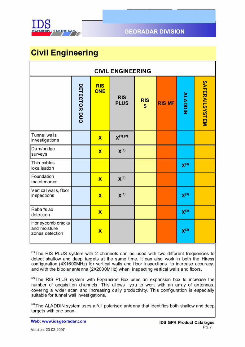
(1) The RIS PLUS system with 2 channels can be used with two different frequencies to detect shallow and deep targets at the same time. It can also work in both the Hiress configuration (4X1600MHz) for vertical walls and f loor inspections to increase accuracy, and with the bipolar antenna (2X2000MHz) when inspecting vertical walls and floors. (2) The RIS PLUS system with Expansion Box uses an expansion box to increase the number of acquisition channels. This allows you to work with an array of antennas, covering a wider scan and increasing daily productivity. This configuration is especially suitable for tunnel wall investigations.
(3) The ALADDIN system uses a full polarised antenna that identif ies both shallow and deep targets with one scan.
CIVIL ENGINEERING
DETECTO
R DUO
RIS ONE
RIS PLUS
RIS S RIS MF
ALA
DDIN
SAFER
AILSYSTEM
Tunnel walls investigations
X X(1) (2)
Dam/bridge surveys
X X(1)
Thin cables localisation
X(3)
Foundation maintenance
X X(1)
Vertical walls, f loor inspections
X X(1) X(3)
Rebar/slab detection
X X(3)
Honeycomb cracks and moisture zones detection
X X(3)
Civil Engineering

IDS GPR Product Catalogue Pg. 8
Web: www.idsgeoradar.com
GEORADAR DIVISION
Version: 23-02-2007
Transport Engineering
TRANSPORT ENGINEERING
DETECTOR
DU
O
RIS ONE
RIS PLUS RIS S
RIS MF
ALADD
IN
SAFERAILSYSTEM
Railways track investigations X
Asphalt layer thickness evaluation
X
Sinkholes, air bubbles and voids detection
X
Differentiation between clean and fouled ballast for railway
X
Detection of drainage problems and ballast pockets for railway
X
Geological information on railway layers
X
IDS GPR Product Catalogue Pg. 9
Web: www.idsgeoradar.com
GEORADAR DIVISION
Version: 23-02-2007
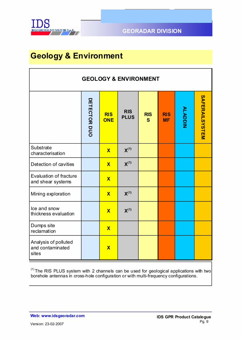
Geology & Environment
(1) The RIS PLUS system with 2 channels can be used for geological applications with two borehole antennas in cross-hole configuration or with multi-frequency configurations.
GEOLOGY & ENVIRONMENT
DETECTOR
DU
O
RIS ONE
RIS PLUS
RIS S
RIS MF
ALADD
IN
SAFER
AILSYSTEM
Substrate characterisation X X(1)
Detection of cavities X X(1)
Evaluation of fracture and shear systems X
Mining exploration X X(1)
Ice and snow thickness evaluation X X(1)
Dumps site reclamation X
Analysis of polluted and contaminated sites
X

IDS GPR Product Catalogue Pg. 10
Web: www.idsgeoradar.com
GEORADAR DIVISION
Version: 23-02-2007
(1) IDS recommends the RIS S system (using up to 5 channels) and RIS MF system (using up to 8 channels) for customers performing medium and large scale survey jobs.
(2) RIS PLUS can work with a bipolar antenna (2X2000MHz) for inspections and the highest available resolution for this type of application.
Archeology & Cultural Heritage
ARCHAEOLOGY & CULTURAL HERITAGE
DETECTO
R D
UO
RIS ONE
RIS PLUS
RIS S
RIS MF
ALADD
IN
SAFERAILSYSTEM
Archaeological site mapping X(1) X(1)
Detection of cavities and buried tunnels X X(1) X(1)
Fresco investigations X X(2)
Statue inspections X X(2)
Mapping of church floors X(1) X(1)
Ancient structure integrity analysis X X(2)

IDS GPR Product Catalogue Pg. 11
Web: www.idsgeoradar.com
GEORADAR DIVISION
Version: 23-02-2007
Forensic & Security
FORENSIC & SECURITY
DETEC
TOR DU
O
RIS ONE
RIS PLUS
RIS S
RIS MF
ALADD
IN
SAFER
AILSYSTEM
Research of human remains and graves
X
Bank security investigations
X X
Detection of caches and cavities
X X
Bugs and arms detection inside structures
X X
UXO detection
X
UXO detection inside structures
X X

IDS GPR Product Catalogue Pg. 12
Web: www.idsgeoradar.com
GEORADAR DIVISION
Version: 23-02-2007
!" EASY TO USE AND TRANSPORT !" HIGHEST PRODUCTIVITY WITH A SINGLE SCAN
!" HIGHEST PERFORMANCE WITH SIMULTANEOUS VIEW OF DEEP AND SHALLOW TARGETS
!" DETECTS METALLIC AND NON-METALLIC UTILITIES
!" DATA SAVING AND REVIEW !" EASY REAL TIME DATA INTERPRETATION IN
KEY FEATURES
Detector Duo Easy-to-use, full featured, GPR for on-site detection of pipes and utilities, dedicated to non-expert users who need to verify the presence of underground utilities before starting trenching or no-dig operations. The Detector Duo features a high performance Radar Unit and a user-friendly software interface. With new dual frequency antenna at 250 MHz and 700 MHz, Detector Duo provides on the same screen simultaneous real time results of deep and shallow targets and locates the exact position of pipes and cable. No more need to replace the antenna and cover the same site twice. You can detect shallow and deep targets with a single scan saving time and costs.

IDS GPR Product Catalogue Pg. 13
Web: www.idsgeoradar.com
GEORADAR DIVISION
Version: 23-02-2007
!" Weight (without laptop and with battery): 15 Kilograms (33 Pounds)
!" Survey speed: 9 Kilometres/h (5.6 Miles/h)
!" Battery operating time (without laptop): More than 10 hours
!" Environmental conditions: IP65
!" Power supply: SLA battery
!" “On the fly” battery replacement: YES
!" Humidity: 100% (sealed)
!" Plant size without handle (L x W): 68 x 80 centimetres
!" Data collection type: 2D (single antenna)
!" Survey path width: 0.5 meters
!" Number of recording channels: $" no. 1 at 250 MHz $" no. 1 at 700 MHz
!" Antenna frequencies: 250 MHz and 700 MHz
!" Typical collection speed: 100 scans/second
!" Sampling interval: 2.5 centimetres
!" Type of calibration gain: Automatic
!" Typical range: Automatic (128 nanoseconds)
!" Data playback: YES
!" Data printing (with pipe descriptions): YES
!" Operative system: Windows 2000 Pro / XP Pro
!" Display mode: Color/grey scale palette
!" Recommended laptop: Panasonic CF-19 Tough-book or bright sunlight readable Hammerhead HF54
Detector Duo: Technical Specs

IDS GPR Product Catalogue Pg. 14
Web: www.idsgeoradar.com
GEORADAR DIVISION
Version: 23-02-2007
HARDWARE The RIS product family is a comprehensive set of innovative, high performance GPR products designed to fulfill all the user applications from utility mapping, to civil engineering, structure surveys, roads and railways surveys, archaeology and forensics. The RIS technology was the first to introduce in the GPR world the concepts of mult i-channels, multi-frequency, multi-polarization and array (or CART) radars into the GPR world. The RIS family of products is based on the K2 DAD (Digital Antenna Driver), the unique fully digital Radar Control Unit featuring unsurpassed performance and flexibility of usage. K2 DAD comes in two different versions, from the 1 - channel entry level to the 2-channel model, which can be expanded up to 8-channels with the addition of a special expansion box. Each K2 DAD is fully compatible with all the IDS antennas, from the 25 MHz to the 2000 MHz, offering total application flexibility. The ALADDIN basic kits come as integrated package of K2 DAD with related antennas and cables. The RIS family is composed of the following models:
#" RIS ONE #" RIS PLUS #" ALADDIN
A set of 1 to 8 radar channels, compatible with all low frequency unshielded antennas (25, 40 MHz), shielded antennas (from 80 to 2000 MHz), and borehole antennas. A comprehensive set of survey kits and accessories offering top performance in very different GPR applications. The two channels based GPR— offered with high frequency, polarised antennas — for no destructive structure analysis and investigations.
#" RIS S #" RIS MF
The two array-based GPR systems (CART), offering unsurpassed performance in the utilities detection, mapping and soil classification.
AVAILABLE MODELS
SOFTWARE The RIS family includes a set of radar data processing software tools specialized for each specific application (see the specs in the dedicated section).
RIS Family

IDS GPR Product Catalogue Pg. 15
Web: www.idsgeoradar.com
GEORADAR DIVISION
Version: 23-02-2007
Channel No.
Antenna compatibility
Survey kit Area Application
RIS ONE 1 All unshielded, shielded and
borehole antennas
Trolley, Structural kit,
Car kit, Backpack kit, Railway kit
Utility (2 ), Geology,
Civil Engineering, Transportation, Archaeology
Utility detection & mapping,
Roads & Bridges analysis, Railway
RIS PLUS 2, 3-8(3)
RIS S 5 TR200 TR400
TR600 (1) Trolley Utility Utility detection
& mapping
RIS MF 8 TR200 TR600 (1) Trolley Utility
Utility detection & mapping &
soil classification
ALADDIN 2 Bipolar 2.0 GHz
Car Kit, (4) Handle Kit Civil Engineering Structure
Analysis
(1) The RIS S and MF DAD control unit is compatible with any antennas.
(2) The compact RIS ONE system represents the entry level for utilities detection and mapping with its single antenna; this entry level system can be upgraded up to the more complete GPR systems (RIS S/MF) at a later date, by adding other antennas as required. (3) By the addition of the Expansion Box assembled with the DAD MCH (4) ALADDIN Car kit is supplied with a patented Pad Survey Guide (PSG), a plastic pad for useful fast, sole-hand, exact survey.
RIS Product Structure

IDS GPR Product Catalogue Pg. 16
Web: www.idsgeoradar.com
GEORADAR DIVISION
Version: 23-02-2007
Handbar kit for ground surveys with low-
medium frequency shielded antenna
4-wheel trolley for util ity
detection with low-medium frequency antenna
Backpack kit with high frequency antenna
Backpack kit for geological surveys with very low
frequency antenna
RIS ONE The entry level 1-channel system covers all applications where only 1 antenna is needed, such as geological surveys, simple road investigations, civil engineering analysis and cultural heritage surveys. The K2 acquisition software is used to acquire radar data, save them and review them later. In addition, the RIS-ONE is the only evolving GPR, it can be upgraded step-by-step to the RIS-S or RIS-MF system.
RIS-ONE uses the GRED 3D elaboration software. This provides easy data selection and handling for visualization and processing. Boreholes and known features can be displayed on screen to improve the interpretation of radargrams and depth-slice maps. 3D data sets can be easily constructed and displayed within a 3D cube. RIS ONE can be provided with a light trolley for only TR200/400/600 or DUAL-F antenna (this configuration requires DAD MCH)

IDS GPR Product Catalogue Pg. 17
Web: www.idsgeoradar.com
GEORADAR DIVISION
Version: 23-02-2007
LAPTOP
DAD 1CH
SURVEY KIT #" Hand-bar kit for
pavement and ground surveys.
#" Structure kit for precise 3D structure a n d b u i l d i n g analysis .
#" Backpack kit for geological and civil e n g i n e e r i n g applications.
#" L ight t rolle y fo r TR200/400/600 or DUAL-F antennas
1 ANTENNA #" Unshielded antennas: (25, 40 MHz).
#" Shielded antennas (80, 100, 200, 400, 600, 900, 1600, 2000 MHz).
#" Borehole antennas: (150, 300 MHz)
ELABORATION SW #" GRED 3D
#" GRED-LAYER-T
RIS ONE: system components
IDS GPR Product Catalogue Pg. 18
Web: www.idsgeoradar.com
GEORADAR DIVISION
Version: 23-02-2007
2x600 MHz kit 600-1600 MHz kit
2 GHz frequency antenna for 3D maps of structures
RIS PLUS
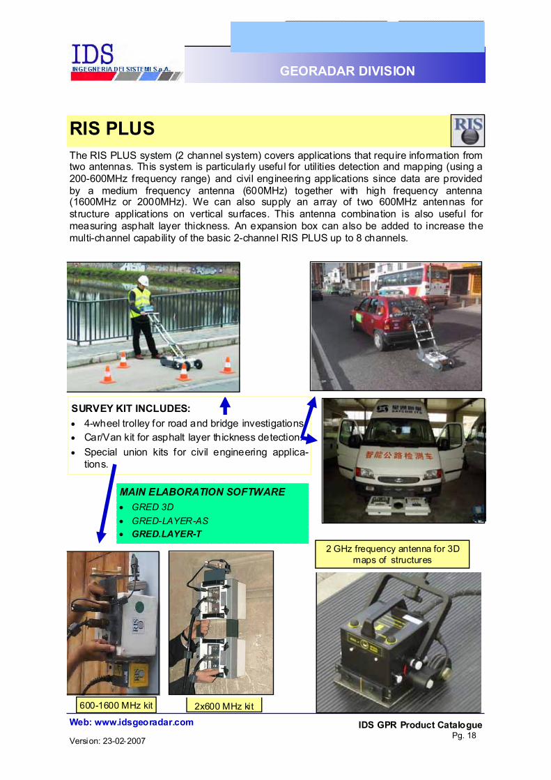
MAIN ELABORATION SOFTWARE #" GRED 3D #" GRED-LAYER-AS #" GRED.LAYER-T
SURVEY KIT INCLUDES: #" 4-wheel trolley for road and bridge investigations. #" Car/Van kit for asphalt layer thickness detection. #" Special union kits for civil engineering applica-
tions.
The RIS PLUS system (2 channel system) covers applications that require information from two antennas. This system is particularly useful for utilities detection and mapping (using a 200-600MHz frequency range) and civil engineering applications since data are provided by a medium frequency antenna (600MHz) together with high frequency antenna (1600MHz or 2000MHz). We can also supply an array of two 600MHz antennas for structure applications on vertical surfaces. This antenna combination is also useful for measuring asphalt layer thickness. An expansion box can also be added to increase the multi-channel capability of the basic 2-channel RIS PLUS up to 8 channels.

IDS GPR Product Catalogue Pg. 19
Web: www.idsgeoradar.com
GEORADAR DIVISION
Version: 23-02-2007
LAPTOP
DAD 2CH
SURVEY KIT #" RIS S/M F trolley.
#" Handbar kit f or pav em ent and ground surveys.
#" 4-wheel trolley fo r asphalt road su rveys .
#" St ructure kit f or prec is e 3D analysis of structu res and bu ild ings.
#" B ackpack kit f or geo logical and c ivil engineering applicat ions.
ANTENNAS
#" Unshielded Antennas : (25 , 40 M Hz).
#" Shielded an tennas(80, 100, 200, 400, 600 , 900, 1600 , 2000 M Hz).
#" Borehole an tennas: (150, 300 MHz)
#" Special antennas: (TRMFTX, TRM FRX, TRM FS MA , HIRES S, BIPO LAR, DUA L-F)
ELABORATION SW
#" GRED 3D
#" GRED-LA YER-T (t unnels)
#" GRED-LA YER-AS (b ridges)
RIS PLUS: system components
Possible configurations: !" 600 -1600 MHz Horizontal !" 600 -1600 MHz Vertical !" 200 - 600 MHz Horizontal !" 200 -100 MHz Horizontal !" 400 - 600 MHz Horizontal !" 200 - 400 MHz Horizontal !" 2.0 GHz Bipolar
EXPANSION BOX

IDS GPR Product Catalogue Pg. 20
Web: www.idsgeoradar.com
GEORADAR DIVISION
Version: 23-02-2007
The array based radar system dedicated to utility detection and mapping The RIS S system has been designed to obtain a three dimensional view of the soil and enable an industrial approach to utilities detection, whilst remaining remarkably simple to use.
FULLY MODULAR Expandable to array configurations. Just attach other antenna modules to perform 3D array surveys.
1 CH
3 CH
5 CH
RIS S
1
3 2 1
1 2 3 4 5
Thanks to its multi-channel features and to the use of an antenna array, the RIS S ra-dar system is well adapted toapproach a wide variety of applications with a high qualitative profile. RIS S can operate with an array of ITR 400 MHz antennas and can be configured in various geometries, with antennas operat-ing both in monostatic and bistatic modes. This system can also be configured with different antenna frequencies: such as 200 MHz, 400 MHz and 600 MHz. The RIS S systems for tradit ional excava-tion sectors consist of mono and or multi-frequency antenna arrays (200, 400 and 600 MHz), and enable 3D cartographic maps of utility networks to be created
ELABORATION SOFTWARE: #" GRED-ROAD
#" GEO MAP
IDS GPR Product Catalogue Pg. 21
Web: www.idsgeoradar.com
GEORADAR DIVISION
Version: 23-02-2007
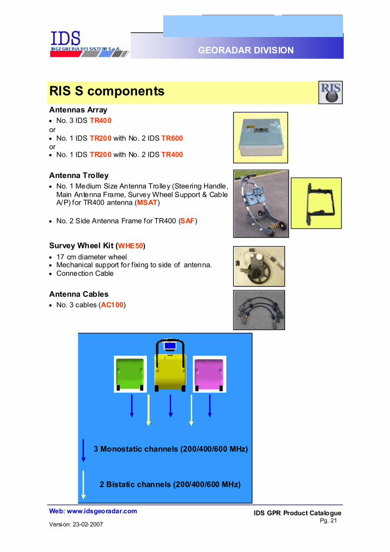
Antennas Array #" No. 3 IDS TR400 or #" No. 1 IDS TR200 with No. 2 IDS TR600 or #" No. 1 IDS TR200 with No. 2 IDS TR400
Antenna Trolley #" No. 1 Medium Size Antenna Trolley (Steering Handle,
Main Antenna Frame, Survey Wheel Support & Cable A/P) for TR400 antenna (MSAT)
#" No. 2 Side Antenna Frame for TR400 (SAF)
Survey Wheel Kit (WHE50) #" 17 cm diameter wheel #" Mechanical support for f ixing to side of antenna. #" Connection Cable
Antenna Cables #" No. 3 cables (AC100)
3 Monostatic channels (200/400/600 MHz)
2 Bistatic channels (200/400/600 MHz)
RIS S components

IDS GPR Product Catalogue Pg. 22
Web: www.idsgeoradar.com
GEORADAR DIVISION
Version: 23-02-2007
#"
4 CH
6 CH
8 CH
GPS option
RIS MF The array radar system designed for detection, mapping and soil classification RIS MF is specially designed for utility detection and soil classif ication. It is equipped with an array of multi-frequency antennas, allowing a high resolution survey of the shallower depths to be performed using four 600 MHz and two 200 MHz antennas, whilst guaranteeing the de-sired depth range (up to 6 meters depending on ground characteristics). This system is specifically developed to perform network detection and mapping and support both traditional excavation activities and trenchless technology. RIS MF features multi-frequency and multipolarisation ar-rays, with 200 to 600 MHz antennas which permit the crea-tion of 3D cartography maps of the utility networks together with maps of the lithological characteristics of the area, es-pecially useful for trenchless technology. In fact the pres-ence of 4 monostatic channels (3x600 + 1x200), 2 bistatic channels (2x200) and 2 cross-polar channels (1x200 + 1x600-200) guarantees the most advanced GPR technol-ogy, the cross-polar channels providing information that can be used for soil recognit ion and classification after processing with the dedicated SUBREM software.
ELABORATION SOFTWARE:
#" GRED-ROAD
#" GEO MAP
#" GRED-SUBREM

IDS GPR Product Catalogue Pg. 23
Web: www.idsgeoradar.com
GEORADAR DIVISION
Version: 23-02-2007
Antenna Master MF (TR SMA) #"No. 1 Subsoil Multi-frequency Antenna
(IDSTR SMA) #"Antenna Type: shielded dipoles #"Nominal Frequency: 600 and 200 MHz #"Built-in multiplexer unit
Antenna (TRMFTX) #"No. 1 ITRMFTX Antenna #"Antenna Type: shielded ground coupled
dipoles #"Nominal Frequency: 600 and 200 MHz
Antenna (TRMFRX) #"No. 1 TRMFRX Antenna #"Antenna Type: shielded ground coupled
dipoles #"Nominal Frequency: 600 and 200 MHz
4 Monostatic channels (3x600 + 1x200MHz)
2 Bistatic channels (2x200MHz)
2 Cross-Polar channels (1x200 + 1x200-600MHz)
RIS MF: antennas

IDS GPR Product Catalogue Pg. 24
Web: www.idsgeoradar.com
GEORADAR DIVISION
Version: 23-02-2007
Antenna 65cm long cable #" No. 5 cables (AC65 D) #" No. 1 cable (AC65 P)
Antenna Trolley (LSAT & LSH) A large size antenna trolley and two side an-tenna frame, composed by: #" No. 1 Large Size Antenna Trolley (LSAT) #" No. 1 Main Antenna Frame (into LSAT). #" No. 1 Survey Wheel Support for SMA an-
tenna (included into LSAT) #" No. 1 A/P Cable for SMA antenna (into
LSAT) #" No. 1 Large Steering Handle (LSH) #" No. 2 Side antenna frame for TRMFTX and
TRMFRX antennas (SAF)
Survey Wheel Kit (WHE50) #" Wheel (17 cm of diameter)
#" Mechanical support for antenna side
#" 50cm metric wheel cable (MWC-50)
RIS MF: system components

IDS GPR Product Catalogue Pg. 25
Web: www.idsgeoradar.com
GEORADAR DIVISION
Version: 23-02-2007
ALADDIN
The ALADDIN system is a specialized GPR sys-tem dedicated for civil engineering applications such as non destructive concrete and structure investigations or seismic qualif ication of building. It locates cracks and voids, moisture and thin ca-bles in concrete or any other materials.
Provided with 2 channels DAD, ALADDIN is de-signed to detect shallow and deep rebar, concrete thickness and consistency with the highest 3D im-aging resolution. It is supplied with a special Pad Survey Guide (PSG) that enables the sole operator to run prop-erly the survey for insuring precise and fast acqui-sitions
The ALADDIN system is provided with the 2GHz bipolar antenna that it permits to acquire orthogo-nal scans in only one direction detecting and map-ping shallow and deep targets within a sole RA-DAR map. Fully compatible with all IDS Antennas, ALADDIN is provided as integrated solution with the dedi-cated 3D GRED software for on-site data process-ing
The multi-channel, multi-frequency GPR system dedicated for non destructive struc-ture analysis

IDS GPR Product Catalogue Pg. 26
Web: www.idsgeoradar.com
GEORADAR DIVISION
Version: 23-02-2007
Antennas (included in SK BASIC KIT):
$" No. 1 bipolar 2.0 GHz Antenna (BIP).
Survey Kit (SK PSG PAD KIT): $" No. 1 Cart and handle $" No.1 Encoder, PSG pad (all included in trans-
port case)
Antenna cables: $" No.2 AC65 cables Software:
$" K2 Acquisition $" GRESWIN (included in Survey Kit)
$" GRED 3D
ALADDIN: system components
FULL POLAR ANTENNA
+
PSG
PC LAPTOP
TRANSPORT & OPERATIONAL
DAD MCH
GRED 3D tomo output

IDS GPR Product Catalogue Pg. 27
Web: www.idsgeoradar.com
GEORADAR DIVISION
Version: 23-02-2007
The SafeRailSystem has been specifically designed to allow detailed inspections of railbeds. The SafeRailSystem can be specif ically configured to provide series of different solutions according to customer requirements, including coach mounting to perform surveying up to speed of 100 Km/h. It permits also the following : $" A regular high speed (up to 100 Km/h) survey of the undertrack conditions on the rail
network $" The identif ication of undertrack conditions down to a depth of 3 meter below the top
of the rail (or at greater depths if required) including the identification of ballast thickness, ballast pockets, level of water tables, amounts of fines in the ballast layers (ballast fouling, qualitative)
The SafeRailSystem consists of a dedicated SRS Control Unit and of multi-channel array of antennas. The most common configuration uses arrays of 400 MHz antennas. According to special requirements, we can include dedicated antenna with frequencies ranging from 100 to 900 MHz, depending on the type of investigation ELABORATION SOFTWARE
#" SRS-Acq; Acquisition software package
#" SRS-DP; Radar Data processing software
#" SRS-AR, Analysis, Display and Reporting of the output results
SafeRailSystem

IDS GPR Product Catalogue Pg. 28
Web: www.idsgeoradar.com
GEORADAR DIVISION
Version: 23-02-2007
LAPTOP DL SRS
CU SRS Dedicated 4 channel An-
tennna control unit
SURVEY KIT #" Doppler encoder for high
speed surveys #" Aluminum Vertical Bracket
and arm for holding antennas on horizontal bar kit
#" Aluminum horizontal Bar kit for antennas and encoder
ANTENNAS #" No.3 or 4 SRS 400 MHz
ELABORATION SW
#" SRS Acq
#" SRS DP
#" SRS AR
SafeRailSystem: system components

IDS GPR Product Catalogue Pg. 29
Web: www.idsgeoradar.com
GEORADAR DIVISION
Version: 23-02-2007
DAD 1CH
1 CHANNEL RADAR CONTROL UNIT FOR RIS ONE SYSTEM
DAD 1CH
DAD (Digital Antenna Driver) Radar Control Units
Technical Specification: #" Compatible with all IDS TR Single Antenna
#" Pulse Repetition Frequency: 400 KHz.
#" Scan Rate: up to 850 Scans/sec.
#" Range: up to 9999 nsec.
#" Number of samples per scan: 128-8192.
#" Sample size: 16 bit.
#" Resolution: better than 5 psec.
#" Stacking: up to 32768 scans, automatic or user selectable.
#" Ports: ANTENNA 1, WHEEL, LAN, BATTERY
#" Maximum number of connectable antennas: 1
#" Maximum number of channels: 1
#" Data Collection: survey wheel driven or continuous motion profiling
#" CE compliant.
DAD Mechanical and operational: #" Dimensions (LxWxH): 22x17x5.5cm
#" Weight: 1.2 Kg
#" Power supply: 12V +/- 10%
#" Water and dust proof (IP 65).
#" Maximum Power Consumption: 8W.

IDS GPR Product Catalogue Pg. 30
Web: www.idsgeoradar.com
GEORADAR DIVISION
Version: 23-02-2007
DAD MCH FOR RIS PLUS SYSTEMS 2 CHANNELS RADAR CONTROL UNIT FOR RIS PLUS, PLUS/E, MF
DAD MCH
Technical Specifications: #" Pulse Repetition Frequency: 400 KHz. #" Scan Rate: up to 850 Scans/sec. #" Range: up to 9999 nsec. #" Sample size: 16 bit. #" Resolution: better than 5 psec. #" Number of samples per scan:
#" 128-8192 (1 channel); #" 128-4096 (2 channels), 128-2048 (4 channels).
#" Stacking: up to 32768 scans, automatic or user selectable. #" Compatible with all IDS TR Antennas #" DAD Ports: ANTENNA 1, ANTENNA 2, WHEEL, #" LAN, BATTERY. #" Maximum number of connectable antennas: 2* #" Maximum number of channels: 4* #" Data Collection: survey wheel driven or continuous motion profiles #" CE compliant. *Expandable up to 8 antennas, 8 channels by connecting an expansion box. DAD MCH specifications: #" Dimensions (LxWxH): 22x17x5.5cm #" Weight: 1.5 Kg #" Temperature: -40°C / 50°C #" Power supply: 12V +/- 10% #" Water and dust proof (IP 65). #" Maximum Power Consumption: 8W (1 antenna), #" 13W (2 antennas), 16W (3 antennas), #" 19W (4 antennas), 22W (5 antennas), #" 25W (6 antennas). EXPANSION BOX specifications: #" Dimensions (LxWxH): 27x19x5.5cm #" Weight: 2 Kg #" Temperature: -40°C / 50°C #" Water and dust proof (IP 65). #" Compatible with all IDS TR Antennas #" Maximum number of connectable antennas: 8 #" Maximum number of channels: 8 #" Max expansion box Ports: ANT 1, ANT 2, ANT 3, ANT 4, ANT 5, ANT 6, ANT 7, ANT 8.
EXPANSION BOX
DAD Radar Control Units

IDS GPR Product Catalogue Pg. 31
Web: www.idsgeoradar.com
GEORADAR DIVISION
Version: 23-02-2007
Antenna 80 MHz (TR80) Separated transmitter and receiver antennas permit bi-static data collection (antennas can be spaced up to 1 meter apart). #" Antenna Type: Shielded dipole #" Nominal Frequency: 80 MHz #" Configuration: Bi-static #" Dimensions (LxWxH):140(max)x70x30 cm #" Weight: 23 Kg #" Rel ative humidit y: <90 % (non-
condensing) #" Rain Proof (IP 65) #" Supplied with AC100 cable and drag kit
Antenna 100 MHz (TR100) Split transmitter and receiver antennas per-mit bi-static data collection (antennas can be spaced up to 1 meter apart). #" Antenna Type: shielded ground-coupled
dipole #" Nominal Frequency within the ground:
100 MHz #" Configuration: Bi-static and mono-static #" Dimensions (LxWxH): 190(max)x45x30
cm (bistatic); 90x70x30 cm (monostatic) #" Weight: 22 Kg #" Rel ative humidit y: <90 % (non-
condensing) #" Rain Proof (IP 65) #" Supplied with AC100 cable and drag kit
Antenna 200 MHz (TR200) #" Antenna Type: shielded dipole #" Nominal Frequency: 200 MHz #" Dimensions (LxWxH): 43x37x20 cm #" Weight: 6 Kg #" Rel ative humidit y: <90 % (non-
condensing) #" Rain Proof (IP 65) #" Supplied with anchor plate for Antenna
drag kit
Shielded Antennas

IDS GPR Product Catalogue Pg. 32
Web: www.idsgeoradar.com
GEORADAR DIVISION
Version: 23-02-2007
Antenna 400 MHz (TR400) #" Antenna Type: shielded dipole #" Nominal Frequency: 400 MHz #" Dimensions (LxWxH): 43x37x20 cm #" Weight: 5.5 Kg #" Relative humidity: <90% (non-condensing) #" Rain Proof (IP 65) #" Supplied with anchor plate for Antenna
drag kit
Antenna 600 MHz for horizontal survey (TR600 H)
#" Antenna Type: shielded dipole #" Nominal Frequency: 600 MHz #" Dimensions (LxWxH): 43x37x20 cm #" Weight: 5.5 Kg (model TR600H) #" Relative humidity: <90% (non-condensing) #" Rain Proof (IP 65) #" Job surface: dedicated for horizontal sur-
veys #" Supplied with anchor plate for Antenna
drag kit
Antenna 600 MHz for vertical survey (TR600 V)
#" Antenna Type: shielded dipole #" Nominal Frequency: 600MHz #" Dimensions (LxWxH): 20x26x20 cm #" Weight: 3 Kg #" Relative humidity: <90% (non-condensing) #" Rain-proof (IP 65) #" Supplied with anchor plate for Antenna
drag kit #" Job surface: dedicated for vertical surveys
Shielded Antennas

IDS GPR Product Catalogue Pg. 33
Web: www.idsgeoradar.com
GEORADAR DIVISION
Version: 23-02-2007
Antenna 900 MHz (TR900) #" Antenna Type: shielded dipole #" Nominal Frequency: 900MHz #" Dimensions (LxWxH): 20x26x20 cm #" Weight: 3 Kg #" Relative humidity: <90% (non-condensing) #" Rain-proof (IP 65)
Antenna 2.0 GHz (TR–HF) #" Antenna Type: shielded ground-coupled
dipole #" Nominal Frequency: 2000 MHz #" Dimensions (LxWxH): 13x12x8 cm #" Weight: 1.3 Kg #" Relative humidity: <90% (non-condensing) #" Rain-proof (IP 65) #" Supplied with the Survey wheel kit (WHE
20) and with 15m long antenna cable(AC1500)
#"
Antenna 2.0 GHz (TR BIP) #" Antenna Type: shielded ground-coupled
bipolar dipole (2X2000) #" Nominal Frequency: 2000 MHz #" Channel number: 2 #" Dimensions (LxWxH): 12.4x12.4x18.5 cm
without sliding kart. #" Weight: 1.5 Kg #" Relative humidity: <90% (non-condensing) #" Rugged assembly (IP 65)
Shielded Antennas

IDS GPR Product Catalogue Pg. 34
Web: www.idsgeoradar.com
GEORADAR DIVISION
Version: 23-02-2007
Antenna 25 MHz (TR25) #" Separated transmitter and receiver anten-
nas (TX-RX spaced up to 1 meter). #" Antenna Type: Unshielded Dipole #" Nominal Frequency: 25 MHz #" Configuration: Bi-static #" Antenna size (LxWxH): 400x120x55 cm #" Dipole size: 200x3,6 cm #" Weight: 18 Kg #" Relative humid ity: < 90% (non-
condensing) #" Rain Proof (IP 65) #" Supplied with a mechanical kit for moving
and a 2m antenna cable (AC200)
Antenna 40 MHz (TR40)
#" Separated transmitter and receiver anten-nas (TX-RX spaced up to 1 meter).
#" Antenna Type: Unshielded Dipole #" Nominal Frequency: 40 MHz #" Configuration: Bi-static #" Antenna size (LxWxH): 274x120x55 cm #" Dipole size: 137x3,6 cm #" Weight: 18 Kg #" Relative humid ity: < 90% (non-
condensing) #" Rain Proof (IP 65) #" Supplied with a mechanical kit for moving
and a 2m antenna cable (AC200) #" The same hand frame can be used for
both antennas, simply change the 4 di-pole TX-RX. (25 or 40 MHz).
Unshielded Antennas
IDS GPR Product Catalogue Pg. 35
Web: www.idsgeoradar.com
GEORADAR DIVISION
Version: 23-02-2007
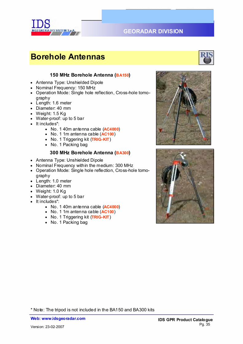
150 MHz Borehole Antenna (BA150) #" Antenna Type: Unshielded Dipole #" Nominal Frequency: 150 MHz #" Operation Mode: Single hole reflection, Cross-hole tomo-
graphy #" Length: 1.6 meter #" Diameter: 40 mm #" Weight: 1.5 Kg #" Water-proof: up to 5 bar #" It includes*:
#" No. 1 40m antenna cable (AC4000) #" No. 1 1m antenna cable (AC100) #" No. 1 Triggering kit (TRIG-KIT) #" No. 1 Packing bag
300 MHz Borehole Antenna (BA300) #" Antenna Type: Unshielded Dipole #" Nominal Frequency within the medium: 300 MHz #" Operation Mode: Single hole reflection, Cross-hole tomo-
graphy #" Length: 1.0 meter #" Diameter: 40 mm #" Weight: 1.0 Kg #" Water-proof: up to 5 bar #" It includes*:
#" No. 1 40m antenna cable (AC4000) #" No. 1 1m antenna cable (AC100) #" No. 1 Triggering kit (TRIG-KIT) #" No. 1 Packing bag
Borehole Antennas
* Note: The tripod is not included in the BA150 and BA300 kits

IDS GPR Product Catalogue Pg. 36
Web: www.idsgeoradar.com
GEORADAR DIVISION
Version: 23-02-2007
Antenna 600/1600MHz (TR-AL) #" Antenna Type: shielded dipole #" Nominal Frequency: 600 and 1600MHz #" Channels No.: 1 #" Size (LxWxH): 43x37x20 cm #" Weight: 5 Kg #" Relative humidity: <90% (non-
condensing) #" Rain-proof (IP 65)
Antenna RIS MF Central (TRMF SMA) #" Antenna Type: shielded dipoles #" Nominal Frequency: 600 and 200 MHz #" Channels No.: 4 #" Built-in multiplexer unit #" Size (LxWxH): 71x45x20 cm #" Weight: 10 Kg #" Rel ative humidit y: <90 % (non-
condensing) #" Rain-proof (IP 65)
Antenna RIS MF Lateral (TRMFTX or TRMFRX)
#" Antenna Type: shielded dipoles #" Nominal Frequency: 600 and 200 MHz #" Channels No.: 2 (if coupled with TRMF
SMA) #" Size (LxWxH): 43x37x20 cm #" Weight: 6 Kg #" Rel ative humidit y: <90 % (non-
condensing) #" Rain-proof (IP 65)
Antenna 200/600 MHz (DUAL-F) #" Antenna Type: shielded dipoles #" Nominal Frequency: 200 and 600 MHz #" Channels No.: 2 #" Size (LxWxH): 43x37x20 cm #" Weight: 6 Kg #" Rel ative humidit y: <90 % (non-
condensing) #" Rain-proof (IP 65)
Special and Multi-frequency Antennas

IDS GPR Product Catalogue Pg. 37
Web: www.idsgeoradar.com
GEORADAR DIVISION
Version: 23-02-2007
4 x 1600MHz (HIRESS) High Resolution Radar array Equipment for Structural Surveys. #" Array of 8 antenna dipoles (4 transmitters
plus 4 receivers) #" Nominal Frequency: 1600 MHz #" 4 integrated dielectric suspended wheels #" Remote control connector #" Antenna Type: shielded dipole #" Size (LxWxH): 45x15x17 cm #" Weight: 3.7 Kg #" Rel ative humidit y: <90 % (non-
condensing) #" It includes:
#" Built-in distribution box #" Integrated survey wheel #" Telescopic hand bar of 1.5m ex-
tendible up to 2m.
Vertical 2x600MHz Array Radar Array Equipment for Structural Sur-veys.
#" Array of No. 2 TR600 antennas #" Drag Kit (VA600-DK) #" Survey wheel #" Antenna Type: shielded dipole #" Nominal Frequency: 600 MHz #" Dimensions (LxWxH): 20x26x20 cm #" Weight: 8 Kg #" Rel ative humidit y: <90 % (non-
condensing) #" Rain-proof (IP 65)
Special and Multi-frequency Antennas

IDS GPR Product Catalogue Pg. 38
Web: www.idsgeoradar.com
GEORADAR DIVISION
Version: 23-02-2007
Vertical 600MHz & 2.0GHz Array Radar Array Equipment for Structural Surveys #" Array of TR600 antenna and TR-HF
antennas #" Drag Kit (VA600-TRHF-DK) #" Survey wheel #" Antenna Type: shielded ground-coupled
dipole #" Nominal Frequency: 600 and 1600 MHz #" Dimensions (LxWxH): 20x26x20 cm #" Weight: 7 Kg #" Rel ative humidit y: <90 % (non-
condensing) #" Rain-proof (IP 65)
Special and Multi-frequency Antennas

IDS GPR Product Catalogue Pg. 39
Web: www.idsgeoradar.com
GEORADAR DIVISION
Version: 23-02-2007
Sled for SMA Antenna (AS-TRSMA) #"Specially designed for surveys on rough
surfaces using RIS MF central antenna (TRMF SMA).
#"Dimensions (LxWxH): 80x50x30 cm #"Weight: 12 Kg
Single Antenna Drag Kit (ADK) #"A single antenna handle for horizontal
surveys (for TR200, TR400, TR600H, TR900 antennas).
#"Dimensions (LxWxH): 36x4x130 cm #"Weight: 0.7 Kg
Antenna Drag Kit for TR-AL (ADK-TRAL) #"An handle for pavement surveys with 600
+1600MHz Antenna (TR-AL) #"Dimensions (LxWxH): 36x4x130 cm #"Weight: 0.7 Kg #" It includes:
#"No. 1 steering handle #"No. 2 sides with 4 wheels
Light Trolley #" One light antenna trolley only for TR
200/400/600 and DUAL-F antennas #" Not upgradeable for further configurations #"Dimensions (LxWxH): 36x4x130 cm #"Weight: 0.7 Kg #" #" It includes:
#"Metric wheel KIT and cable #"Dedicated back for DAD and battery #" Sun Shield
RIS Survey kits

IDS GPR Product Catalogue Pg. 40
Web: www.idsgeoradar.com
GEORADAR DIVISION
Version: 23-02-2007
Antenna Trolley for RIS ONE and RIS S(MSAT, SAF) #" One medium size antenna trolley and two2
antenna side frames. #" n°1 Medium Size Antenna Trolley with
Steering Handle, Main Antenna Frame, Survey Wheel Support & Cable A/P (MSAT)
#" n°1/2 Side Antenna Frame for TR200/TR400/TR600 antennas (SAF)
#" MSAT Size (LxWxH): 40x75x21.3 cm (without the steering handle)
#" MSAT Weight: 6.5 Kg #" Temperature: -40°C / 50°C #" SAF Size: (LxWxH): 76x41x15 cm #" SAF Weight: 4 Kg
Sledge for TR80 or TR100 (AS) #"Specially designed for surveys on rough
surfaces using an 80MHz or 100MHz an-tenna.
#"Dimensions (LxWxH): 80x50x30 cm #"Weight: 12 Kg #" It includes:
#"No. 1 TR80, TR100 Sledge with 2 wheels
#"No. 1 Steringe Handle
RIS Survey kits

IDS GPR Product Catalogue Pg. 41
Web: www.idsgeoradar.com
GEORADAR DIVISION
Version: 23-02-2007
Antenna Trolley for RIS MF (LSAT, SAF) It includes a large antenna trolley and two side antenna frames. #" No. 1 Large Size Antenna Trolley. #" No. 1 Steering Handle. #" No. 1 Main Antenna Frame. #" No. 1 Survey Wheel Support for SMA an-
tenna #" No. 1 Cable A/P for SMA antenna #" No. 2 Side antenna frame for TRMFTX and
TRMFRX #" LSAT Size (LxWxH): 79.5x75x21.3 cm #" LSAT Weight: 6.5 Kg #" SAF Size (LxWxH): 76x41x15 cm (without
the steering handle) #" SAF Weight: 4 Kg
TR AL Antenna Trolley: (ADK-TRAL) #" A medium size antenna trolley designed for
pavement applications with TR AL antenna.
RIS Survey kits

IDS GPR Product Catalogue Pg. 42
Web: www.idsgeoradar.com
GEORADAR DIVISION
Version: 23-02-2007
Survey Wheel Kit (WHE20) #" 6 cm diameter wheel #" Mechanical support for fixing to the an-
tenna #" Connection cable #" Dimensions (LxWxH): 13x9x6 cm #" Weight: 0.3 Kg #" Relative humidity: <90% (non-condensing) #" IP65
Survey Wheel Kit (WHE50) #" 17 cm diameter wheel #" Mechanical support for fixing to the an-
tenna #" Connection cable #" Dimensions (LxWxH): 11x6x3 cm #" Weight: 0.9 Kg #" Relative humidity: <90% (non-condensing) #" IP65
Survey Wheel Kit (WHE100) #" 34 cm diameter wheel #" Mechanical support for fixing to the an-
tenna #" Connection cable #" Dimensions (LxWxH): 35x10x50 cm #" Weight: 2.2 Kg #" Relative humidity: <90% (non-condensing) #" IP65
Borehole Survey Wheel Kit (WHE BH) #" 17 cm diameter wheel #" Mechanical support for fixing to borehole
antenna #" Connection cable #" Dimensions (LxWxH): 13x9x6 cm #" Weight: 1.5 Kg #" Relative humidity: <90% (non-condensing) #" IP65
RIS Accessories

IDS GPR Product Catalogue Pg. 43
Web: www.idsgeoradar.com
GEORADAR DIVISION
Version: 23-02-2007
HIP Chain Encoder (HCE) #" For unshielded antennas #" Metric Walktax Distance Measurer m/dm #" Feet Walktax Distance Measurer feet/inch #" Reel Cotton Thread Reels, 10-pack. #" Dimensions (LxWxH): 15x8x9 cm #" Weight: 0.5 Kg #" Relative humidity: <90% (non-condensing) #" IP65
Tripod for borehole antenna (T-BH) #" Metallic structure. #" Dimensions: (LxWxH): 100x15x30 cm
extendible up to 1.8m of height #" Weight: 5 Kg
Acquisition backpack kit (BP) #" Kit for DAD control unit #" Dimensions: (LxWxH): 60x35x30 cm #" Weight: 0.35 Kg #" Metallic support for laptop #" Safety belt #" Bag for battery
Shipping box (SHI-BOX) #" It contains No.1 DAD, No.1 Antenna,
various accessories #" Dimensions (LxWxH): 80x50x30 cm #" Weight: 12 Kg #" IP65
RIS Accessories

IDS GPR Product Catalogue Pg. 44
Web: www.idsgeoradar.com
GEORADAR DIVISION
Version: 23-02-2007
SLA BATTERY (SLA-BAT) #" Sealed Lead Acid Battery
#" Nominal Voltage: 12 VDC. #" Nominal Capacity: 12 Ah.
LITION BATTERY (LI-BAT) #" Lithium Ion Battery:
#" Nominal Voltage: 14.4VDC.
#" Nominal Capacity: 5.8Ah
SLA BATTERY CHARGER (SLA-CH) #" Sealed Leads Acid Battery Charger
#" Input: 90/250VAC (50/60Hz) #" Nominal Power: 40W
#" Output current: 2,5A
LITION BATTERY CHARGER (LI-CH) #" Lithium Ion Battery Charger: #" Input: 90/250VAC (50/60Hz)
#" Nominal Power: 40W
#" Output current: 2A
RIS Accessories

IDS GPR Product Catalogue Pg. 45
Web: www.idsgeoradar.com
GEORADAR DIVISION
Version: 23-02-2007
BATTERY CASE (BAT-CASE) #" Battery case for SLA Battery or for LI/ION
Battery
LAN CABLE (LAN CABLE) #" LAN Cable for connecting the Control Unit
to the LAN of the notebook.
BATTERY CABLE (C-B) #" Power Supply Cable for connecting the
Control Unit to the Battery.
ANTENNA CABLES #" N° 1 cable #" Standard Available lengths:
$" AC65 D/P (65cm); AC100 (1m); $" AC200 (2m); AC300 (3m); $" AC500 (5m); AC1500 (15m); $" AC2000 (20m); AC3000 (30m); $" AC4000 (40m).
#" Different lengths available on request. #" Temperature: -40°C / 50°C #" Relative humidity: <90% (non-condensing) #" IP65
RIS Accessories
METRIC WHEEL CABLES (MWC) Cable for connecting the encoder (odometer) to the antenna
#" Standard available lengths: $" MWC-50 (50cm); MWC-75 (75cm); $" MWC-90 (90cm); MWC-140 (140cm); $" MWC-200 (2m); MWC-300 (3m); $" MWC-500 (5m); MWC-1500 (15m); $" MWC-1500 FD (15m) for transportation field
IDS GPR Product Catalogue Pg. 46
Web: www.idsgeoradar.com
GEORADAR DIVISION
Version: 23-02-2007
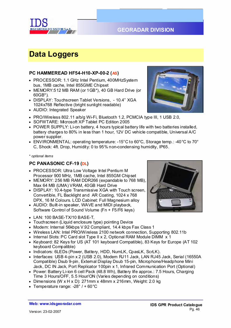
PC HAMMEREAD HF54-H10-XP-00-2 (AS) #" PROCESSOR: 1.1 GHz Intel Pentium, 400MHzSystem
bus, 1MB cache, Intel 855GME Chipset #" MEMORY:512 MB RAM (or 1GB*), 40 GB Hard Drive (or
60GB*). #" DISPLAY: Touchscreen Tablet Versions, - 10.4’’ XGA
1024x768 Reflective (bright sunlight readable) #" AUDIO: Integrated Speaker
#" PRO/Wireless 802.11 a/b/g Wi-Fi, Bluetooth 1.2, PCMCIA type III, 1 USB 2.0, #" SOFWTARE: Microsoft XP Tablet PC Edition 2005 #" POWER SUPPLY: Li-on battery, 4 hours typical battery life with two batteries installed,
battery charges to 80% in less than 1 hour, 12V DC vehicle compatible, Universal A/C power supplier.
#" ENVIRONMENTAL: operating temperature: -15°C to 60°C, Storage temp.: -40°C to 70°C, Shock: 4ft. Drop, Humidity: 0 to 95% non-condensing humidity, IP65.
* optional items
PC PANASONIC CF-19 (DL) #" PROCESSOR: Ultra Low Voltage Intel Pentium M
Processor 900 MHz, 1MB cache, Intel 855GM Chipset #" MEMORY: 256 MB RAM DDR266 (expandable to 768 MB),
Max 64 MB (UMA) VRAM, 40GB Hard Drive #" DISPLAY: 10.4-type Transmissive XGA with Touch screen,
Convertible, FL Backlight and AR Coating, 1024 x 768 DPX, 16 M Colours. LCD Cabinet: Full Magnesium alloy
#" AUDIO: Built-in speaker, WAVE and MIDI playback, Software Control of Sound Volume (Fn + F5/F6 keys)
#" LAN: 100 BASE-TX/10 BASE-T, #" Touchscreen (Liquid enclosure type) pointing Device #" Modem: Internal 56kbps V.92 Compliant, 14.4 kbps Fax Class 1 #" Wireless LAN: Intel PRO/Wireless 2100 network connection, Supporting 802.11b #" Internal Slots: PC Card slot Type II x 2, Optional RAM Module DIMM x 1 #" Keyboard: 82 Keys for US (AT 101 keyboard Compatible), 83 Keys for Europe (AT 102
keyboard Compatible) #" Indicators: 6LEDs (Power, Battery, HDD, NumLK, CpasLK, ScrLK). #" Interfaces: USB 4-pin x 2 (USB 2.0), Modem RJ11 Jack, LAN RJ45 Jack, Serial (16550A
Compatible) Dsub 9-pin, External Display Dsub 15-pin, Microphone/Headphone Mini Jack, DC IN Jack, Port Replicator 100pin x 1, Infrared Communication Port (Optional)
#" Power: Battery Li-ion 6 cell Pack (48.8 Wh), Battery life approx.: 7.5 Hours, Charging Time 3 Hours/OFF, 5.5 Hour/ON (Varies depending on conditions)
#" Dimensions (W x H x D): 271mm x 48mm x 216mm, Weight: 2.0 kg #" Temperature range: -28° / + 60°C
Data Loggers
IDS GPR Product Catalogue Pg. 47
Web: www.idsgeoradar.com
GEORADAR DIVISION
Version: 23-02-2007
Software
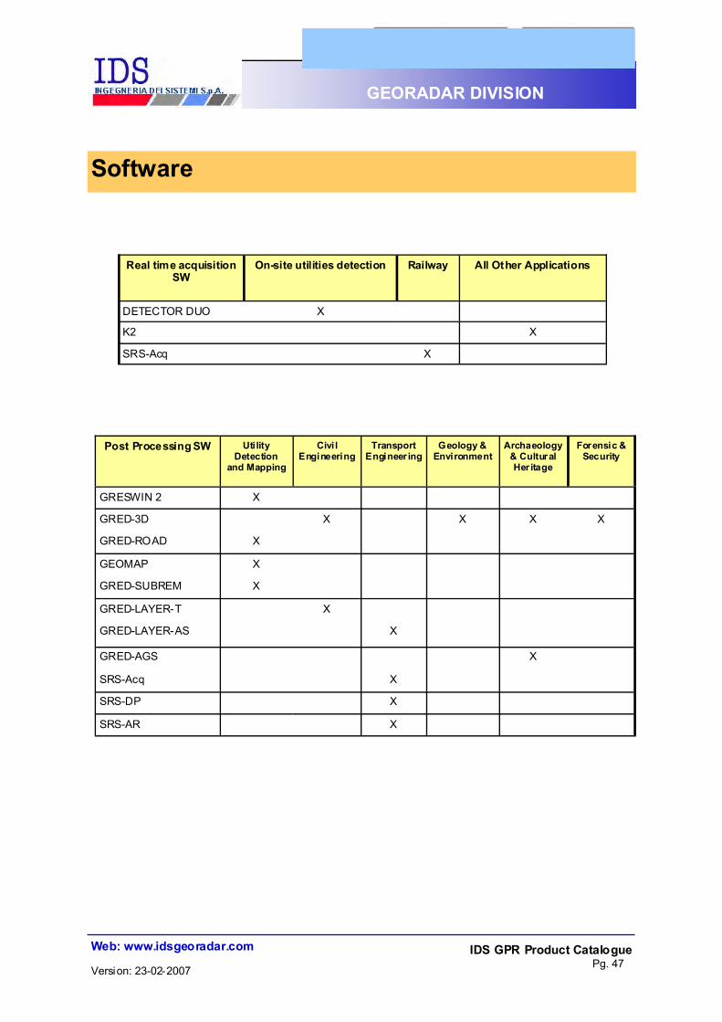
DETECTOR DUO X
K2 X
Real time acquisition SW
On-site utilities detection
All Other Applications Railway
SRS-Acq X
Post Processing SW Uti lity Detection
and Mapping
Civi l Engineering
Transport Engineer ing
Geology & Environment
Archaeology & Cultural Her itage
Forensic & Security
GRESWIN 2 X
GRED-3D X X X X
GRED-ROAD X
GEOMAP X
GRED-SUBREM X
GRED-LAYER-T X
GRED-LAYER-AS X
GRED-AGS X
SRS-DP X
SRS-AR X
SRS-Acq X
IDS GPR Product Catalogue Pg. 48
Web: www.idsgeoradar.com
GEORADAR DIVISION
Version: 23-02-2007
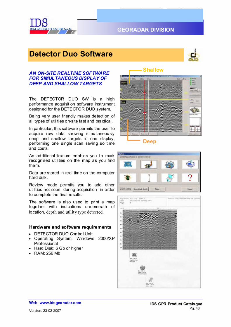
AN ON-SITE REALTIME SOFTWARE FOR SIMULTANEOUS DISPLAY OF DEEP AND SHALLOW TARGETS
The DETECTOR DUO SW is a high performance acquisit ion software instrument designed for the DETECTOR DUO system. Being very user friendly makes detection of all types of utilities on-site fast and practical. In particular, this software permits the user to acquire raw data showing simultaneously deep and shallow targets in one display, performing one single scan saving so time and costs.
An additional feature enables you to mark recognised utilities on the map as you find them.
Data are stored in real time on the computer hard disk.
Review mode permits you to add other utilit ies not seen during acquisition in order to complete the f inal results.
The software is also used to print a map together with indications underneath of location, depth and utility type detected.
Hardware and software requirements #" DETECTOR DUO Control Unit #" Operating System: Windows 2000/XP
Professional #" Hard Disk: 6 Gb or higher #" RAM: 256 Mb
Detector Duo Software
Shallow
Deep

IDS GPR Product Catalogue Pg. 49
Web: www.idsgeoradar.com
GEORADAR DIVISION
Version: 23-02-2007
K2 A SIGNAL ACQUISITION SOFTWARE
K2 SW is a high-performance, multi-channel software instrument designed for georadar data collection and post-processing under Windows 2000/XP Professional. Features: #" Usable with a s ingl e antenna
configuration (in this case the multi-channel facilities are not available).
#" Usable with array of antennas (enabling maximum performance).
#" Control a sophisticated automatic signal calibration system.
#" Control a complete diagnostic instrument to continuously control the apparatus eff iciency level.
#" GPS connectable through a simple tool that manages the GPS data and saves it in real t ime according to user input.
#" Data are stored in real time on the computer hard disk.
#" Two channels of collected radar gram can be visualised simultaneously in real-time on the screen during the acquisition phase — NEW!!!
RIS Acquisition Software
Hardware and software requirements #" DAD Control Unit #" Operating System: Windows 2000/XP Professional #" Hard Disk: 6 Gb or more #" RAM: 256 Mb

IDS GPR Product Catalogue Pg. 50
Web: www.idsgeoradar.com
GEORADAR DIVISION
Version: 23-02-2007
GRESWIN 2 ON SITE ELABORATION SOFTWARE
Data can be processed on site with the Greswin 2 SW which features: #" time-domain filters. #" migration algorithm. #" Gain. #" background removal filter. #" envelop detector, etc. The correct position of detected targets in X and Z coordinates can be estimated (just using the mouse) thanks to a sophisticated propagation velocity evaluation algorithm. HW and SW requirements #" DAD Control Unit #" Operating System: Windows 2000/XP
Professional #" Hard Disk: min. 6 Gb #" RAM: 256 Mb
RIS Elaboration Software

IDS GPR Product Catalogue Pg. 51
Web: www.idsgeoradar.com
GEORADAR DIVISION
Version: 23-02-2007
GRED 3D AN ADVANCED GPR PROCESSING AND IMAGING SOFTWARE
GRED 3D is an easy to use advanced processing software designed to be the optimal interface for the IDS RIS GPR system family. This software operates both with single GPR sections and with sets of homogeneously acquired single or mult i channel profile data. The modular design of Gred 3D, just like that of the RIS family, allows you to build up your system as your application needs evolve (civil engineering, geology, environment, etc.). KEY FEATURES #" Easy import and processing of multi-channel—multi-frequency GPR data. #" GPS location #" Data quality control module #" Advanced 2D filtering #" Flexible data handling and visualization #" Spatial data representation and processing #" 2D picking and 3D cube representation #" Enhanced interpretation tools #" Standard printing and image export #" Dedicated engineering modules with advanced interpretation tools Hardware and Software Requirements: #" Pentium 4, MTM or Better (1 GHz minimum recommended) #" Microsoft WindowsTM 2000 or XP Professional #" 256 MB RAM Minimum #" SVGA—32 MB video card minimum #" 30 MB free hard disk space
RIS Elaboration Software
2D TOMOGRAPHIC VIEW 3D CUBIC VIEW

IDS GPR Product Catalogue Pg. 52
Web: www.idsgeoradar.com
GEORADAR DIVISION
Version: 23-02-2007
GRED-ROAD DATA ELABORATION SW FOR UTILITY MAPPING
GRED-ROAD for Windows 2000 is an industrial software dedicated to processing RIS data and generating cartographic output. The environment has been designed to provide highly interactive and efficient management of the large quantity of data acquired by the RIS Acquisition Unit. The 2 monitor configuration permits you to view radargrams as multiple sections (standard rep resentation) together wi th the tomographic view. Results of the data analysis can be transferred to CAD either using an interactive link or at the end of the work session. In the latter case, IDSGeomap automatica lly generates the f ina l cartographic output. All the radar data and analysis results are stored in a relational data base, in order to have both a historical archive and be able to rapidly and eff iciently search and select data . Data elaboration, including disturbance and noise reduction filters, gain equalisation, tomographic elaboration and estimation of propagation parameters (penetration depth, propagation velocity, attenuation, etc.) is fully automatic, thus avoiding mistakes in inserting processing variables and guaranteeing working times HW and SW requirements:
RIS Elaboration Software
#" IBM compatible Pentium III PC #" AUTOCAD 2000 or newer versions #" 1 GHz or higher #" Microsoft Windows 2000/XP Professional
#" 256 Mb RAM #" Data Base: Microsoft Access 2000
#" Double monitor #" GEO MAP SW

IDS GPR Product Catalogue Pg. 53
Web: www.idsgeoradar.com
GEORADAR DIVISION
Version: 23-02-2007
GEO MAP LINKING SOFTWARE BETWEEN DATABASE AND CAD ENVIRONMENT
GEO MAP is a professional tool running under Microstation SE or Autocad 2000/2002/2004 versions, dedicated to the cartographic management of RIS survey's results by working on data coming from GRED-ROAD SW. GEO MAP allows you to: #" draw the GPR survey reference line (including curved lines) simply by keying in
distances from reference points. #" automatically insert cartographic elements onto the CAD map (e.g. position of covers,
electricity and gas meters, street numbers and building entrances, etc.), according to the reference line utilised during the GPR survey.
#" automatically position utilities detected by analysing GPR data with respect to the reference line.
#" select the desired drawing format or customise it by choosing paper dimensions, scale factor, etc., so that the f inal product meets the specific application requirements.
#" automatically generate the legend and the t itle block of the drawing. #" automatically generate transverse, longitudinal and rectified sections of the investigated
area. These characteristics mean that IDSGeomap drastically reduces costs, freeing you from boring routine procedures and wasting working time.
HW and SW requirements: #" IBM compatible Pentium III PC 1 GHz or higher, #" 256 Mb RAM, #" Operating system: Windows 2000, #" GRED-ROAD, #" CAD SW: Bentley Microstation SE and/or Autocad 2000/2002/2004.
RIS Elaboration Software

IDS GPR Product Catalogue Pg. 54
Web: www.idsgeoradar.com
GEORADAR DIVISION
Version: 23-02-2007
GRED-SUBREM SUBSURFACE ANALYSIS SW FOR SUBSOIL RECOGNITION
GRED-SUBREM is a professional software instrument which works along with GRED standard functions to automatically elaborate RIS data. GRED-SUBREM software includes advanced "pattern recognition" algorithms which provide information related to the nature of the investigated medium, whatever it may be (e.g. ground, concrete, asphalt, etc.). SubReM has been designed to satisfy the requirements of No-Dig operators, containing a series of ground characteristics which can be helpful when planning a utilities installation. However, the software also includes additional tools (e.g. horizontal and vertical segmentation procedures) suitable for other types of applications (such as structural investigations of buildings).
Radar Map
Segmentation Map
Layering Map
Soil Classification Map
The software supplies 4 different images, each of them related to a particular characteristic of the subsurface: #" the horizontal segmentation map
allows the evaluation of the GPR penetration profile and therefore highlights homogeneous areas along the radar scan direction.
#" the layering map provides information about the main layers present in the investigated subsurface.
#" the ground classification map can reveal some ground characteristics, helpful to No-Dig operators when choosing the right equipment.
#" the conventional radargram can be used for detecting targets within the investigated medium.
HW and SW requirements
#" Data must be collected by the RIS MF system, #" IBM compatible Pentium III PC 1 GHz or
higher, #" 256 Mb RAM, #" Win 2000/XP Professional, #" SW: GRED-ROAD. #" AUTOCAD 2000 or newer versions #" Microsoft Access
RIS Elaboration Software

IDS GPR Product Catalogue Pg. 55
Web: www.idsgeoradar.com
GEORADAR DIVISION
Version: 23-02-2007
GRED-LAYER-T SPECIALISED FOR TUNNEL ANALYSIS AND INVESTIGATIONS
GRED-LAYER-T is a professional software designed to support and verify tunnel covering thickness. The 3D version allows you to view the concrete morphology through to the extrados and investigate the thickness at the desired progressive coordinate. Different types of notes can be inserted such as damage, presence of moisture water, location of centerings, and if the thickness is lower than design requirements. GRED LAYER for TUNNELS can also evaluate the volume of micro-piles and can make suggestions in terms of design consolidation.
Main features are: #" automatic elaboration of data. #" manual or semi-automatic layer thickness detection. #" synthetic output of layer information. #" automatic legend. #" printing of end results. #" various editing functions on the radar maps. #" export to excel. HW and SW requirements: #" IBM compatible Pentium III PC 1 GHz or higher. #" 256 Mb RAM. #" Operating system: Windows 2000/XP Professional
RIS Elaboration Software

IDS GPR Product Catalogue Pg. 56
Web: www.idsgeoradar.com
GEORADAR DIVISION
Version: 23-02-2007
GRED-LAYER-AS SPECIALIZED FOR STREET AND BRIDGES APPLICATIONS
GRED-LAYER-AS for streets and bridges is a professional software instrument designed for layer analysis. This software includes advanced "pattern recognition" algorithms which provide information about the different layers in terms of material composition. The code can identify the various layers using both automatic and manual procedures. Up to 8 parallel radar maps can be viewed simultaneously and the sections run using automatic scrolling. All the radar data are stored in a relational data base both to have a historical archive and obtain rapid and efficient data searching and selection. Main applications are: #" Street and bridge layer thickness analysis. #" Analysis of sinkings and other anomalies. #" Underground geometry determination. Main features are: #" automatic data elaboration #" manual or semi-automatic detection of layers. #" synthetic output of layer information. #" automatic legend. #" printing of end results. #" various editing functions on the radar maps. #" export to excel. HW and SW requirements: #" IBM compatible Pentium III PC 1 GHz or higher. #" 128 Mb RAM. #" Operating system: Windows 2000/XP Professional
RIS Elaboration Software
IDS GPR Product Catalogue Pg. 57
Web: www.idsgeoradar.com
GEORADAR DIVISION
Version: 23-02-2007
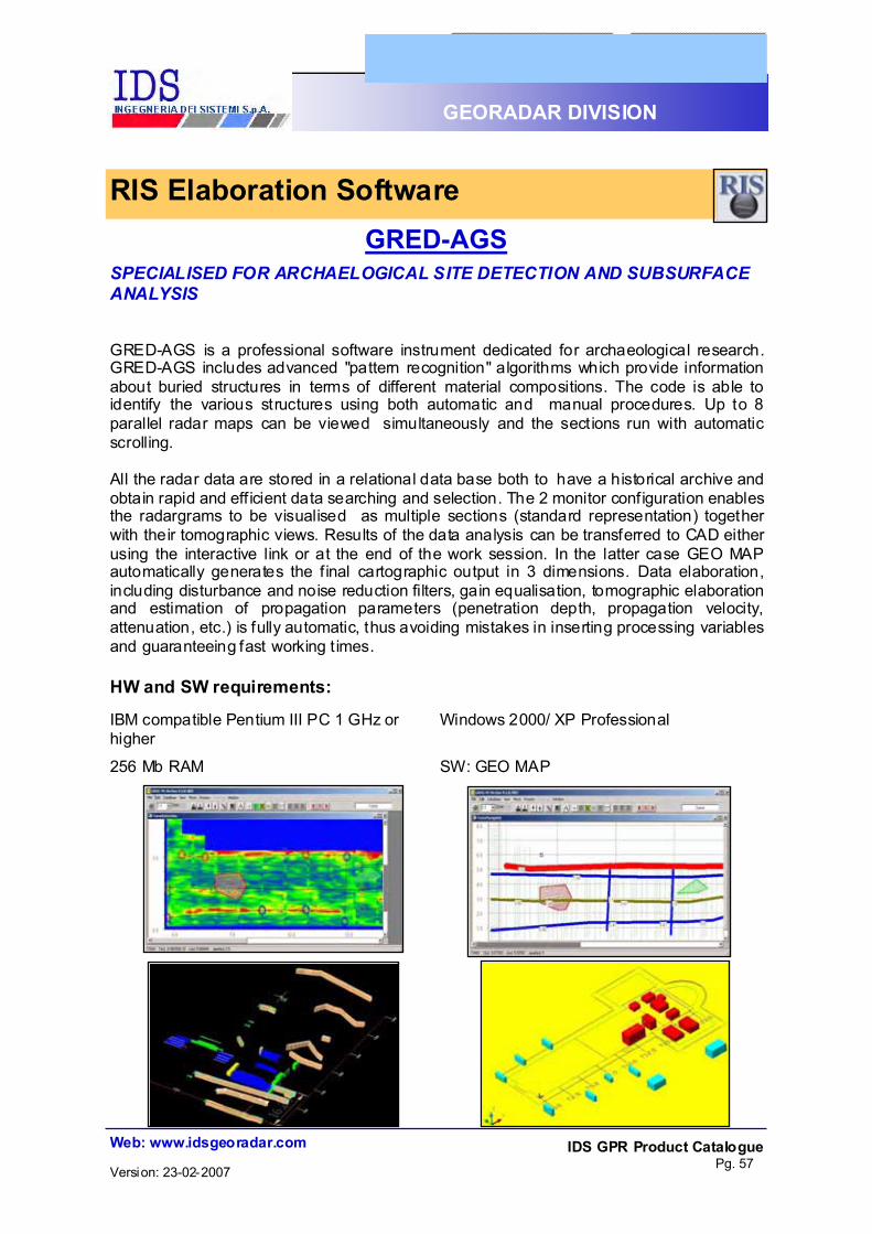
GRED-AGS SPECIALISED FOR ARCHAELOGICAL SITE DETECTION AND SUBSURFACE ANALYSIS
GRED-AGS is a professional software instrument dedicated for archaeological research. GRED-AGS includes advanced "pattern recognition" algorithms which provide information about buried structures in terms of different material compositions. The code is able to identify the various structures using both automatic and manual procedures. Up to 8 parallel radar maps can be viewed simultaneously and the sections run with automatic scrolling. All the radar data are stored in a relational data base both to have a historical archive and obtain rapid and eff icient data searching and selection. The 2 monitor configuration enables the radargrams to be visualised as multiple sections (standard representation) together with their tomographic views. Results of the data analysis can be transferred to CAD either using the interactive link or at the end of the work session. In the latter case GEO MAP automatically generates the f inal cartographic output in 3 dimensions. Data elaboration, including disturbance and noise reduction filters, gain equalisation, tomographic elaboration and estimation of propagation parameters (penetration depth, propagation velocity, attenuation, etc.) is fully automatic, thus avoiding mistakes in inserting processing variables and guaranteeing fast working t imes.
IBM compatible Pentium III PC 1 GHz or higher
Windows 2000/ XP Professional
256 Mb RAM SW: GEO MAP
RIS Elaboration Software
HW and SW requirements:

IDS GPR Product Catalogue Pg. 58
Web: www.idsgeoradar.com
GEORADAR DIVISION
Version: 23-02-2007
SRS-Acq SPECIALISED FOR GEORADAR DATA COLLECTION FROM TRACK-LINE
INVESTIGATION
This software permit to manage all the functions of the multi-channels control unit CU SRS.
The SRS-Acq SW controls:
#" a sophisticated automatic signal calibration system
#" a complete diagnostic instrument for a continuous check-up of the eff iciency level of
the machine
#" the start point coordinates
#" the management of the Doppler encoder for the position of the radar data
GPS connection and Video Camera, is also available as option, through a simple tool
managing and saving in real time.
Data are stored in real time into the hard disk of the computer.
the radar data can be selected in a rapid and eff icient way. The user can introduce and
SRS Acquisition Software

IDS GPR Product Catalogue Pg. 59
Web: www.idsgeoradar.com
GEORADAR DIVISION
Version: 23-02-2007
SRS-DP SPECIALISED FOR THE LAYER ANALYSIS FOR RAILWAY APPLICATIONS
This module includes advanced "pattern recognition" algorithms, which provide user with
information related to the different layer related to the material composition. The code is
able to identify the different layers with semi-automatic or manual railway related
procedures. The user can visualise, simultaneously, up to 4 parallel radar maps and run
this sections with an automatic scrolling. All the radar data can be selected in a rapid and
efficient way. The user can introduce and analyze drilling information.
Main tasks are:
#" Continuous Mapping of Ballast Thickness
#" Differentiation Between Clean and Fouled Ballast
#" Detection of Sections with Drainage Problems
#" Locating Areas with Insuff icient Bearing Capacity (e.g. Ballast Pockets)
#" Mapping Thickness and Quality of Subballast Layers
#" Locating Irregularities along the Track (e.g. Peat, Bedrock etc.)
Main features are:
#" automatic data processing of radar data #" manual or semi-automatic detection of
layer interfaces #" synthetic output of layer information #" automatic legend #" printing of end results in selectable
scale #" various editing functions on the radar
maps
#" export to excel
SRS Elaboration Software

IDS GPR Product Catalogue Pg. 60
Web: www.idsgeoradar.com
GEORADAR DIVISION
Version: 23-02-2007
SRS-AR SPECIALISED FOR ANALYSIS, DISPLAY AND REPORTING OF THE RESULTS PROCESSED WITH SRS-DP PACKAGE
This module permit to have a detailed overview of all the geotechnical relevant parameters,
which enables railway engineers to manage the results and to use them as basis for their
track renewal plans. Main tasks are:
#"Display of the longitudinal stratigraphic sections #"Display of drilling information
#"Display of qualitative geotechnical relevant parameters as Ballast Bed Moisture, Ballast Fouling, Evenness of Track Bed Basis, Moisture Distribution in Intermediate Layer, and Formation Moisture Distribution.
#"Display of Track Bed Cross Section at each Position along the track
#"Video and Pictures viewer compatible #"Display of position of constructions along the track (if
data available)
#"Display of position of various objects, if data available (masts, crossing pipes and cables, etc.)
Main features are:
#" Semi-automatic elaboration of results
#" Automatic generation of cross section
#" Automatic legend #" Printing of results in
selectable scale #" Various editing functions
#" Display of pictures and video with relative coordinates
SRS Elaboration Software

IDS GPR Product Catalogue Pg. 61
Web: www.idsgeoradar.com
GEORADAR DIVISION
Version: 23-02-2007
Branch Office Address Via Sterpulino 20 56121 PISA — ITALY
Headquarters Address: Via Livornese 1019 56010 PISA - ITALY
!"Phone - Switchboard: +39.050.9671.11
! Phone - Sales and Marketing Department: +39.050.9671.23/24/45 E-mail: [email protected]
!"Phone - Customer Care Department: +39.050.9671.22
E-mail: [email protected]
!"Fax - +39.050.9671.21