IASbaba’s 60 Days Plan – Day 30 (Geography)€¦ · The sun is vertically overhead at the...
29
IASbaba’s 60 Days Plan – Day 30 (Geography) 2014 1 Q.1) Consider the following 1. Meteors are burning rocks, while meteorites contain a combination of metal, magnetic elements and nickel. 2. Meteors are typically small in size, while meteorites are larger. Select the correct answer using the codes given below. a) 1 only b) 2 only c) Both 1 and 2 d) None Q.1) Solution (c) Most of us probably have seen meteors or shooting stars. A meteor is the flash of light that we see in the night sky when a small chunk of interplanetary debris burns up as it passes through our atmosphere. "Meteor" refers to the flash of light caused by the debris, not the debris itself. The debris is called a meteoroid. A meteoroid is a piece of interplanetary matter that is smaller than a kilometer and frequently only millimeters in size. Most meteoroids that enter the Earth's atmosphere are so small that they vaporize completely and never reach the planet's surface. If any part of a meteoroid survives the fall through the atmosphere and lands on Earth, it is called a meteorite. Although the vast majority of meteorites are very small, their size can range from about a fraction of a gram (the size of a pebble) to 100 kilograms (220 lbs) or more (the size of a huge, life-destroying boulder). Do you know? Asteroids are generally larger chunks of rock that come from the asteroid belt located between the orbits of Mars and Jupiter. Comets are asteroid-like objects covered with ice, methane, ammonia, and other compounds that develop a fuzzy, cloud-like shell called a coma and sometimes a visible tail whenever they orbit close to the Sun. Q.2) Consider the following statements
Transcript of IASbaba’s 60 Days Plan – Day 30 (Geography)€¦ · The sun is vertically overhead at the...

IASbaba’s 60 Days Plan – Day 30 (Geography) 2014
1
Q.1) Consider the following
1. Meteors are burning rocks, while meteorites contain a combination of metal,
magnetic elements and nickel.
2. Meteors are typically small in size, while meteorites are larger.
Select the correct answer using the codes given below.
a) 1 only
b) 2 only
c) Both 1 and 2
d) None
Q.1) Solution (c)
Most of us probably have seen meteors or shooting stars.
A meteor is the flash of light that we see in the night sky when a small chunk of
interplanetary debris burns up as it passes through our atmosphere. "Meteor" refers to the
flash of light caused by the debris, not the debris itself.
The debris is called a meteoroid. A meteoroid is a piece of interplanetary matter that is
smaller than a kilometer and frequently only millimeters in size. Most meteoroids that enter
the Earth's atmosphere are so small that they vaporize completely and never reach the
planet's surface.
If any part of a meteoroid survives the fall through the atmosphere and lands on Earth, it
is called a meteorite. Although the vast majority of meteorites are very small, their size can
range from about a fraction of a gram (the size of a pebble) to 100 kilograms (220 lbs) or
more (the size of a huge, life-destroying boulder).
Do you know?
Asteroids are generally larger chunks of rock that come from the asteroid belt located
between the orbits of Mars and Jupiter.
Comets are asteroid-like objects covered with ice, methane, ammonia, and other
compounds that develop a fuzzy, cloud-like shell called a coma and sometimes a visible tail
whenever they orbit close to the Sun.
Q.2) Consider the following statements

IASbaba’s 60 Days Plan – Day 30 (Geography) 2014
2
1. In summer solstice (21st June) the northern hemisphere will have the longest day and
shortest night.
2. In winter solstice (22nd December) the southern hemisphere will have the longest
night and shortest day.
Which of the above statements is/are correct?
a) 1 only
b) 2 only
c) Both 1 and 2
d) None
Q.2) Solution (a)
The sun is vertically overhead at the Tropic of Cancer on about 21st June. This is known as
June or Summer solstice, when northern hemisphere will have longest day and shortest
nights.
The sun is vertically overhead at the Tropic of Capricorn on about 22nd December. This is
known as winter solstice, when southern hemisphere will have longest day and shortest
nights.
Do you know?
The tropics mark the limit of the overhead sun, for beyond these, the sun is never
overhead at any time of the year.
THINK!
Dawn
Twilight
Q.3) Your friend is sailing in the ship in Indian ocean is at 750 E longitude calls you. He
wishes you good morning and asks your local time. You being at Greenwich say 7.00am.
What is the actual time of your friend’s place at Indian Ocean?
a) 11.00am
b) 12.00pm
c) 12.30pm
d) None
Q.3) Solution (b)
IASbaba’s 60 Days Plan – Day 30 (Geography) 2014
3
Every 15 degrees of longitude equals 1 hour. So, if you are standing at 0 degrees longitude
(Greenwich) and you move or travel 15 degrees east or west, you'll notice a difference of 1
hour. This 1-hour difference is negative or positive, can be determined by the direction in
which you have traveled i.e westwards or eastwards of the Meridian longitude.
Your friend is at Indian Ocean 750 E longitude, this means in time he is ahead of you. So, we
have to add 75*4=300 minutes or 5 hours to 7.00am. Which gives 12.00pm. Thus, the actual
time of your friend is 12.00 pm.
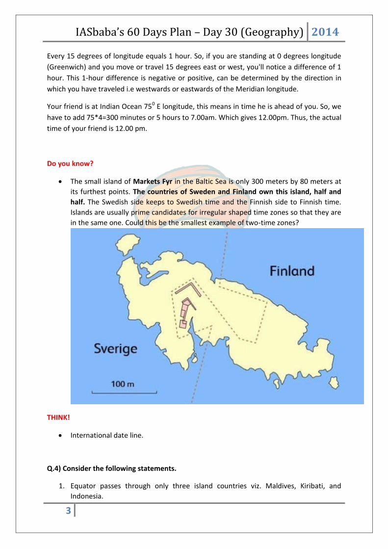
Do you know?
The small island of Markets Fyr in the Baltic Sea is only 300 meters by 80 meters at
its furthest points. The countries of Sweden and Finland own this island, half and
half. The Swedish side keeps to Swedish time and the Finnish side to Finnish time.
Islands are usually prime candidates for irregular shaped time zones so that they are
in the same one. Could this be the smallest example of two-time zones?
THINK!
International date line.
Q.4) Consider the following statements.
1. Equator passes through only three island countries viz. Maldives, Kiribati, and
Indonesia.
IASbaba’s 60 Days Plan – Day 30 (Geography) 2014
4
2. The landmasses of Maldives and Kiribati do not touch the equator itself.
Which of the above statements is/are correct?
a) 1 only
b) 2 only
c) Both 1 and 2
d) None
Q.4) Solution (b)
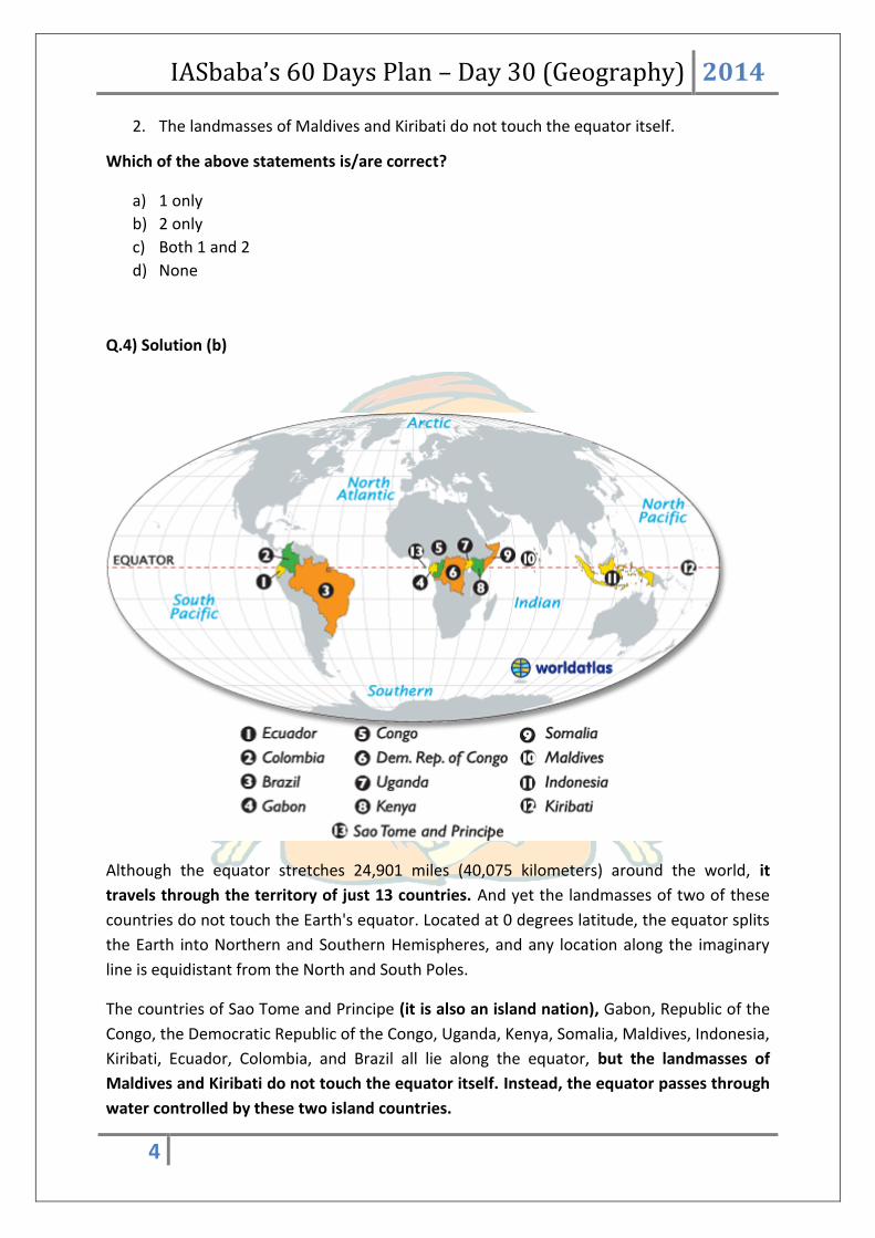
Although the equator stretches 24,901 miles (40,075 kilometers) around the world, it
travels through the territory of just 13 countries. And yet the landmasses of two of these
countries do not touch the Earth's equator. Located at 0 degrees latitude, the equator splits
the Earth into Northern and Southern Hemispheres, and any location along the imaginary
line is equidistant from the North and South Poles.
The countries of Sao Tome and Principe (it is also an island nation), Gabon, Republic of the
Congo, the Democratic Republic of the Congo, Uganda, Kenya, Somalia, Maldives, Indonesia,
Kiribati, Ecuador, Colombia, and Brazil all lie along the equator, but the landmasses of
Maldives and Kiribati do not touch the equator itself. Instead, the equator passes through
water controlled by these two island countries.

IASbaba’s 60 Days Plan – Day 30 (Geography) 2014
5
Seven of the countries are in Africa—the most of any continent—while South America is
home to three of the nations (Ecuador, Colombia, and Brazil) and remaining three
(Maldives, Kiribati, and Indonesia) are island nations in the Indian and Pacific oceans.
Do you know?
The terms summer, fall, winter, and spring don't really apply to regions along the
equator. Instead, people who live in the especially humid tropic regions refer to only
two seasons: wet and dry.
THINK!
Tropic of cancer passes through which all countries?
Q.5) Which of the following are responsible for tides?
1. Gravitational force of sun, moon and rotation of earth.
2. During spring tide, the Sun, Moon, and Earth form a configuration known as a syzygy.
Which of the above statements is/are correct?
a) 1 only
b) 2 only
c) Both 1 and 2
d) None
Q.5) Solution (c)
Tides are the rise and fall of sea levels caused by the combined effects of the gravitational
forces exerted by the Moon and the Sun and the rotation of Earth.
Approximately twice a month, around new moon and full moon when the Sun, Moon, and
Earth form a line (a configuration known as a syzygy), the tidal force due to the sun
reinforces that due to the Moon. The tide's range is then at its maximum; this is called the
spring tide. It is not named after the season, but, like that word, derives from the meaning
"jump, burst forth, rise", as in a natural spring.
Do you know?
The Highest Astronomical Tide is the perigean spring tide when both the sun and
moon are closest to the Earth.
THINK!
Einstein ring
IASbaba’s 60 Days Plan – Day 30 (Geography) 2014
6
Q.6) Which of the following are indirect sources to know interior of earth?
1. Meteors
2. Gravitation
3. Seismic Waves
4. Volcanic eruptions
Select the correct answer using the codes given below.
a) 1, 2 and 3 only
b) 2, 3 and 4 only
c) 1, 3 and 4 only
d) All the above
Q.6) Solution (a)
Sources of Information about the interior of the earth
Direct Sources:
Rocks from mining area
Volcanic eruptions
Indirect Sources
By analyzing the rate of change of temperature and pressure from the surface
towards the interior.
Meteors, as they belong to the same type of materials earth is made of.
Gravitation, which is greater near poles and less at the equator.
Gravity anomaly, which is the change in gravity value according to the mass of
material, gives us information about the materials in the earth’s interior.
Magnetic sources
Seismic Waves: the shadow zones of body waves (Primary and secondary waves)
give us information about the state of materials in the interior.
Do you know?
Mohorovicic (Moho) discontinuity forms the boundary between crust and
asthenosphere [asthenosphere is a part of mantle].
THINK!
Major elements of earth’s crust.

IASbaba’s 60 Days Plan – Day 30 (Geography) 2014
7
Q.7) Consider the following pairs.
Rock Type Example
1. Igneous Granite
2. Metamorphic Gneiss
3. Sedimentary Sandstone
Which of the above pairs is/are correctly matched?
a) 1 only
b) 2 only
c) 1 and 3 only
d) All the above
Q.7) Solution (d)
Igneous Rocks
Formed out of magma and lava and are known as primary rocks.
If molten material is cooled slowly at great depths, mineral grains may be very large.
Sudden cooling (at the surface) results in small and smooth grains.
Granite, gabbro, pegmatite, basalt, etc.are some of the examples of igneous rocks.
There are two types of igneous rocks: intrusive rocks (Granite) and extrusive rocks
(Basalt-Deccan Traps).
Having their origin under conditions of high temperatures, the igneous rocks are
Acid igneous rocks, such as granite, are less dense and are lighter in colour than basic
rocks.
Metamorphic Rocks
The word metamorphic means ‘change of form’.
Form under the action of pressure, volume and temperature (PVT) changes.
Metamorphism occurs when rocks are forced down to lower levels by tectonic
processes or when molten magma rising through the crust comes in contact with the
crustal rocks.
Metamorphism is a process by which already consolidated rocks undergo
recrystallization and reorganization of materials within original rocks.
Granite under pressure metamorphoses into gneiss.
Sedimentary Rocks
Sedimentary or detrital rocks.
Formed as a result of denudation (weathering and erosion).

IASbaba’s 60 Days Plan – Day 30 (Geography) 2014
8
These deposits through compaction turn into rocks. This process is called
lithification.
Cover 75 per cent of the earth’s crust but volumetrically occupy only 5 per cent.
They are layered or stratified of varying thickness. Example: sandstone, shale etc.
Till or Tillite == Ice deposited sedimentary rocks.
Loess == Wind deposited sediments.
Depending upon the mode of formation, they are classified into
mechanically formed — sandstone, conglomerate, limestone, shale, loess etc.
organically formed — geyserite, chalk, limestone, coal etc.
chemically formed — chert, limestone, halite, potash etc.
Do you know?
Metamorphic Rocks in India
The gneisses and schists are commonly found in the Himalayas, Assam, West Bengal,
Bihar, Orissa, Madhya Pradesh and Rajasthan.
Quartzite is a hard rock found over Rajasthan, Bihar, Madhya Pradesh, Tamil Nadu
and areas surrounding Delhi.
Marble occurs near Alwar, Ajmer, Jaipur, Jodhpur in Rajasthan and parts of Narmada
Valley in Madhya Pradesh.
Slate, which is used as a roofing material and for writing in schools, is found over
Rewari (Haryana), Kangra (Himachal Pradesh) and parts of Bihar.
Graphite is found in Orissa and Andhra Pradesh.
THINK!
Rock cycle
Q.8) Consider the following statements regarding the Tropics:
1. The sun is overhead Tropic of Capricorn during Summer Solstice.
2. Tropic of Capricorn and Tropic of Cancer marks the extreme limits where Sun can be
overhead atleast once in a year.
3. In Asia, Tropic of Capricorn passes only through Indonesia.
Which of the above statements are correct?
a) 1 and 2
b) 2 only
c) 2 and 3
d) All of the above
IASbaba’s 60 Days Plan – Day 30 (Geography) 2014
9
Q.8) Solution (b)
Notable Latitudes
The Equator represents 0° latitude, while the North and South Poles represent 90°
North and 90° South latitudes. In addition to the Equator, there are four other major
latitudes that are usually found on maps and globes. The positions of these latitudes
are determined by the Earth's axial tilt.
The Arctic Circle is the latitude 66° 34′ North. All locations falling North of this
latitude are said to be in the Arctic Circle.
The Antarctic Circle on the other hand, is the latitude 66° 34′ south. Any locations
falling south of this latitude are said to be in the Antarctic Circle.
Places in both the Arctic and Antarctic circles experience extreme weather, and
experience the Midnight Sun.
The latitude 23° 26′ North is also known as the Tropic of Cancer. It marks the
northern-most position on the Earth, where the Sun is directly overhead at least
once a year. This happens during the June Solstice, when the Earth’s Northern
Hemisphere is tilted towards the Sun.
The Tropic of Capricorn is the latitude that lies at 23° 26′ South of the Equator. It is
the southern-most position on the globe, where the sun is directly overhead during
the December Solstice.
Sometimes, latitudes north of the Equator are denoted by a positive sign. Latitudes south of
the Equator are given negative values. This eliminates the need to add whether the
specified latitude is north or south of the Equator.
Note: Tropic of Capricorn does not pass through Asia.
Q.9) The earth revolves around the sun in an elliptical path. Consider the following
statements regarding this:
1. The earth is closest to the sun on 3rd January.
2. When the earth is at its maximum distance from sun, it is called Aphelion.
Which of the above statements is/are correct?
a) 1 only
b) 2 only
c) Both 1 and 2
d) Neither 1 nor 2

IASbaba’s 60 Days Plan – Day 30 (Geography) 2014
10
Q.9) Solution (c)
The perihelion is the point in the orbit of a celestial body where it is nearest to its orbital
focus, generally a star. It is the opposite of aphelion, which is the point in the orbit where
the celestial body is farthest from its focus.
Earth is about 147.1 milion kilometers (91.4 million miles) from the Sun at perihelion around
January 3, in contrast to about 152.1 million kilometers (94.5 million miles) at aphelion
around July 4 — a difference of about 5.0 million kilometers (3.1 million miles).
Think
Apogee and Perigee
Q.10) Which of the following factors are responsible for change in seasons on earth?
a) Rotation of the earth on its axis
b) Elliptical orbit of the earth
c) Tilt of the earth’s axis
d) All of the above
Q.10) Solution (c)
Seasons result from the tilt of Earth's axis, which is 23.4 degrees away from perpendicular to
the plane of Earth's orbit around the sun. Winter falls on the hemisphere where sunlight
strikes least directly, and summer falls where sunlight strikes most directly, regardless of the
Earth's distance from the Sun.
IASbaba’s 60 Days Plan – Day 30 (Geography) 2014
11
In the northern hemisphere, summer occurs at the same time as aphelion. Despite this,
there are larger land masses in the northern hemisphere, which are easier to heat than the
seas. Consequently, summers are 2.3 °C (4 °F) warmer in the northern hemisphere than in
the southern hemisphere under similar conditions.
Think
How does season impact the vegetation of a place?
Q.11) A great circle is a circle on the surface of the earth, the plane of which passes
through the center of the earth. Which of the following statements regarding Great Circles
are NOT correct?
1. All latitudes form Great circles.
2. Only one longitude forms a Great Circle.
3. A great circle divides the earth into two equal halves.
Select the code from following:
a) 1 and 2
b) 3 only
c) 1 and 3
d) All of the above
Q.11) Solution (a)
Note: Incorrect options have been asked.
Great Circle
A great circle is the largest possible circle that can be drawn around a sphere. All spheres
have great circles. If you cut a sphere at one of its great circles, you'd cut it exactly in half. A
great circle has the same circumference, or outer boundary, and the same center point as its
sphere. The geometry of spheres is useful for mapping the Earth and other planets.
The Earth is not a perfect sphere, but it maintains the general shape. All the meridians on
Earth are great circles. Meridians, including the prime meridian, are the north-south lines
we use to help describe exactly where we are on the Earth. All these lines of longitude meet
at the poles, cutting the Earth neatly in half.

IASbaba’s 60 Days Plan – Day 30 (Geography) 2014
12
The Equator is another of the Earth's great circles. If you were to cut into the Earth right on
its Equator, you'd have two equal halves: the Northern and Southern Hemispheres. The
Equator is the only east-west line that is a great circle. All other parallels (lines of latitude)
get smaller as you get near the poles.
Do you know?
Great circles are useful in planning routes. The shortest path between two points on the
surface of a sphere is always a segment of a great circle. Plotting great circles comes in very
handy for airplane pilots trying to fly the shortest distance between two points. For
example, if you flew from Atlanta, Georgia, to Athens, Greece, you could fly roughly along
the path of one of Earth's great circles, which would be the shortest distance between those
two points. When planning routes, however, pilots have to take other factors into account,
such as air currents and weather. Great circles are just general paths to follow.
Q.12) Periglacial landforms are one of the evidences of Continental Drift. Which of the
following are the examples of Periglacial landforms?
1. Pingo
2. Blockfields
3. Areti
4. Coombe
Select the code from below:
a) 1,2 and 3
b) 2,3 and 4
c) 1,2 and 4
d) All of the above
Q.12) Solution (c)
Note: Even if you didn’t know the answer, you could have marked it through elimination.
Areti is a glacial landform and not a periglacial landform. It could have been eliminated.
Periglacial Landform
Periglaciation (adjective: "periglacial," also referring to places at the edges of glacial areas)
describes geomorphic processes that result from seasonal thawing of snow in areas of
permafrost, the runoff from which refreezes in ice wedges and other structures.
"Periglacial" suggests an environment located on the margin of past glaciers. However,

IASbaba’s 60 Days Plan – Day 30 (Geography) 2014
13
freeze and thaw cycles influence landscapes outside areas of past glaciation. Therefore,
periglacial environments are anywhere that freezing and thawing modify the landscape in a
significant manner.
Periglaciation results in a variety of ground conditions but especially those involving
irregular, mixed deposits created by ice wedges, solifluction, gelifluction, frost creep and
rockfalls. Periglacial environments trend towards stable geomorphologies.
Coombe and head deposits – Coombe deposits are chalk deposits found below chalk
escarpments in Southern England. Head deposits are more common below outcrops
of granite on Dartmoor.
Patterned Ground – Patterned ground occurs where stones form circles, polygons
and stripes. Local topography affects which of these are expressed. A process called
frost heaving is responsible for these features.
Solifluction lobes – Solifluction lobes are formed when waterlogged soil slips down a
slope due to gravity forming U shaped lobes.
Blockfields or Felsenmeer – Blockfields are areas covered by large angular blocks,
traditionally believed to have been created by freeze-thaw action. A good example
of a blockfield can be found in the Snowdonia National Park, Wales. Blockfields are
common in the unglaciated parts of the Appalachian Mountains in the northeastern
United States, such as at the River of Rocks or Hickory Run Boulder Field, Lehigh
County, Pennsylvania.
Other landforms include:
Bratschen
Palsa
Pingo
Rock glacier
Thermokarst
Think
Glacial Landforms
Since a question on periglacial landforms was asked in mains last year, this year you
might find it in the prelims.
Q.13) Which of the following statements are correct regarding the Earth’s crust?
1. It is the top constituent of lithosphere.
2. Continental crust is called Felsic while oceanic crust is called mafic.
3. Silicon is the most abundant element in the earth’s crust.

IASbaba’s 60 Days Plan – Day 30 (Geography) 2014
14
Select the code from following
a) 1 only
b) 1 and 2
c) 1 and 3
d) All of the above
Q.13) Solution (b)
Earth’s Crust
The crust is a thin shell on the outside of the Earth, accounting for less than 1% of Earth's
volume. It is the top component of lithosphere: a division of Earth's layers that includes the
crust and the upper part of the mantle. The lithosphere is broken into tectonic plates that
move, allowing heat to escape from the interior of the Earth into space.
The crust lies on top of the mantle, a configuration that is stable because the upper mantle
is made of peridotite and so is significantly denser than the crust. The boundary between
the crust and mantle is conventionally placed at the Mohorovicic discontinuity, a boundary
defined by a contrast in seismic velocity.
The crust of the Earth is of two distinctive types:
Oceanic: 5 km (3 mi) to 10 km (6 mi) thick and composed primarily of denser, more
mafic rocks, such as basalt, diabase, and gabbro.
Continental: 30 km (20 mi) to 50 km (30 mi) thick and mostly composed of less
dense, more felsic rocks, such as granite.
Because both continental and oceanic crust is less dense than the mantle below, both types
of crust "float" on the mantle.
Most
Abundant
Elements of
Earth's
Crust
Approximate %
by weight
O 46.6
Si 27.7
Al 8.1

IASbaba’s 60 Days Plan – Day 30 (Geography) 2014
15
Fe 5.0
Ca 3.6
Na 2.8
K 2.6
Mg 1.5
Q.14) Igneous Rocks are the primary rocks of the earth’s crust. Which of the following
statements are correct regarding the igneous rocks?
1. They are formed by cooling and hardening of magma.
2. Igneous rocks are most likely to have fossils in them.
3. Intrusive igneous rocks have bigger crystals than extrusive igneous rocks.
Select the code from following:
a) 1 only
b) 2 and 3
c) 1 and 3
d) All of the above
Q.14) Solution (c)
Types of Rocks
The three main types, or classes, of rock are sedimentary, metamorphic, and igneous and
the differences among them have to do with how they are formed.
Sedimentary
Sedimentary rocks are formed from particles of sand, shells, pebbles, and other fragments
of material. Together, all these particles are called sediment. Gradually, the sediment
accumulates in layers and over a long period of time hardens into rock. Generally,
sedimentary rock is fairly soft and may break apart or crumble easily. You can often see
sand, pebbles, or stones in the rock, and it is usually the only type that contains fossils.
Examples of this rock type include conglomerate and limestone.

IASbaba’s 60 Days Plan – Day 30 (Geography) 2014
16
Metamorphic
Metamorphic rocks are formed under the surface of the earth from the metamorphosis
(change) that occurs due to intense heat and pressure (squeezing). The rocks that result
from these processes often have ribbonlike layers and may have shiny crystals, formed by
minerals growing slowly over time, on their surface.
Examples of this rock type include gneiss and marble.
Igneous
Igneous rocks are formed when magma (molten rock deep within the earth) cools and
hardens. Sometimes the magma cools inside the earth, and other times it erupts onto the
surface from volcanoes (in this case, it is called lava). When lava cools very quickly, no
crystals form and the rock looks shiny and glasslike. Sometimes gas bubbles are trapped in
the rock during the cooling process, leaving tiny holes and spaces in the rock.
Examples of this rock type include basalt and obsidian.
Intrusive igneous rocks get more time to cool down. This gives time to crystal to grow
bigger. On the other hand extrusive rocks cool down soon and small crystal formation is
there.
Do you know?
Igneous rocks are primary rocks because they form directly by the material coming out from
the interior of earth. Sedimentary and metamorphic rocks are a result of external forces.
Q.15) Consider the following statements:
1. The inner planets are those that exist between the sun and the asteroid belt.
2. Mercury, Venus, Earth and Mars are inner planets which are very close to the sun
and are made up of gases and liquids.
Which of the above statements is/are correct?
a) 1 only
b) 2 only
c) Both 1 and 2
d) Neither 1 nor 2
Q.15) Solution (a)

IASbaba’s 60 Days Plan – Day 30 (Geography) 2014
17
All of the inner planets - Mercury, Venus, Earth and Mars - are considered terrestrial planets
due to the fact that their surfaces are made mostly of solids (rocks).
Inner planets have no or few moons, with Earth having one moon, and Mars having two. In
contrast, the outer planets are much more likely to have moons and rings. For example,
Jupiter, known to be the largest planet in the solar system, has several moons. Jupiter,
Saturn and Uranus have rings around them.
Do you know?
Similarities between the inner and outer planets:
The inner and outer planets all follow an elliptical orbit, share the same orbital plane, are
spherical and contain some of the same elements. Besides those attributes, each planet is
very different.
The inner planets are those that exist between the sun and the asteroid belt. They are:
Mercury
Venus
Earth
Mars
The outer planets are those that are between the asteroid belt and the end of the solar
system. These are:
Jupiter
Saturn
Uranus
Neptune
The outer planets are known as Jovian or gas giants. They are much larger in size than the
inner planets and are primarily composed of gases that surround a liquid metal core.
The inner planets are all smaller and denser than the outer planets. They are mostly solid
and composed of rock rather than gas.
The reason for the difference in the size, density, and composition of the planets is that the
gravity of the sun tends to attract heavier, solid elements, such as heavy metals, while
lighter gases, such as hydrogen, helium, nitrogen, and oxygen, are not pulled as strongly
inward.
The elements that exist in all of the planets are iron and nickel. Mercury, the planet closest
to the sun, is almost entirely made of these two elements, while the outer planets only have
trace amounts located in their core.

IASbaba’s 60 Days Plan – Day 30 (Geography) 2014
18
https://www.reference.com/science/outer-planets-solar-system-
6c2ccfedd6b8ff33?qo=leafPageFeaturedContent
Q.16) Consider the following pairs:
1. Isohels/Isohals : : Imaginary lines on a map passing through places of same duration
of sunshine.
2. Isohypse : : Imaginery lines passing through places having the same height from the
sea level.
3. Isohytes : : Lines joining the places on the earth's surface having equal rainfall.
4. Isonephs : : Imaginery lines passing through places having same mean cloudiness
over a certain period.
Which of the pairs given above is/are correct?
a) 1 and 3 only
b) 3 and 4 only
c) 3 only
d) 1, 2, 3 and 4
Q.16) Solution (d)
Isotherm is a line on a map connecting points having the same temperature at a given time
or on average over a given period.
Isobar is a line on a map connecting points having the same atmospheric pressure at a given
time or on average over a given period.
Isohyte is a line on a map joining the places on the earth's surface having equal rainfall.
Isobath is an imaginary line or a line on a map or chart that connects all points having the
same depth below a water surface (as of an ocean, sea, or lake)
Isohel/Isohal is an imaginary line on a map passing through places of same duration of
sunshine.
Isohypse is an imaginary line passing through places having the same height from the sea
level.
Isonephs is an imaginary line passing through places having same mean cloudiness over a
certain period.
Isohaline is a line on a map joining points of equal salinity in an aquatic system.
IASbaba’s 60 Days Plan – Day 30 (Geography) 2014
19
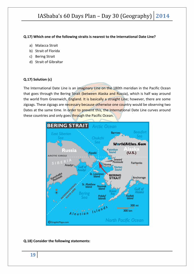
Q.17) Which one of the following straits is nearest to the International Date Line?
a) Malacca Strait
b) Strait of Florida
c) Bering Strait
d) Strait of Gibraltar
Q.17) Solution (c)
The International Date Line is an imaginary Line on the 180th meridian in the Pacific Ocean
that goes through the Bering Strait (between Alaska and Russia), which is half way around
the world from Greenwich, England. It is basically a straight Line; however, there are some
zigzags. These zigzags are necessary because otherwise one country would be observing two
Dates at the same time. In order to prevent this, the International Date Line curves around
these countries and only goes through the Pacific Ocean.
Q.18) Consider the following statements:
IASbaba’s 60 Days Plan – Day 30 (Geography) 2014
20
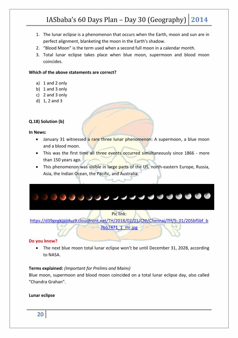
1. The lunar eclipse is a phenomenon that occurs when the Earth, moon and sun are in
perfect alignment, blanketing the moon in the Earth's shadow.
2. “Blood Moon” is the term used when a second full moon in a calendar month.
3. Total lunar eclipse takes place when blue moon, supermoon and blood moon
coincides.
Which of the above statements are correct?
a) 1 and 2 only b) 1 and 3 only c) 2 and 3 only d) 1, 2 and 3
Q.18) Solution (b)
In News:
January 31 witnessed a rare three lunar phenomenon: A supermoon, a blue moon
and a blood moon.
This was the first time all three events occurred simultaneously since 1866 - more
than 150 years ago.
This phenomenon was visible in large parts of the US, north-eastern Europe, Russia,
Asia, the Indian Ocean, the Pacific, and Australia.
Pic link:
https://d39gegkjaqduz9.cloudfront.net/TH/2018/02/01/CNI/Chennai/TH/5_01/205bf5bf_b
7b57471_1_mr.jpg
Do you know?
The next blue moon total lunar eclipse won’t be until December 31, 2028, according
to NASA.
Terms explained: (Important for Prelims and Mains)
Blue moon, supermoon and blood moon coincided on a total lunar eclipse day, also called
"Chandra Grahan".
Lunar eclipse
IASbaba’s 60 Days Plan – Day 30 (Geography) 2014
21
The lunar eclipse is a phenomenon that occurs when the Earth, moon and sun are in
perfect alignment, blanketing the moon in the Earth's shadow.
In total lunar eclipse, the direct sunlight is completely blocked by the earth's shadow.
Blue Moon
"Blue Moon" is the term used when a second full moon in a calendar month. Jan 31
witnessed first lunar eclipse of the year and had second full moon in the month. This
is called "Blue Moon". In addition, the moon will appear crimson in colour.
Blood Moon
During total lunar eclipse, when the moon gets shadowed by earth, the sunlight
passes through the earth's atmosphere and breaks down. The red part of the
sunlight gets least refracted, giving moon the tinge of orangish red. This is called
"Blood Moon".
Supermoon
When the eclipse happened, the moon was close to earth by 60,000 km against the
average distance between the moon and the earth. The moon appeared brighter and
bigger. This is called "supermoon".
Q.19) Which among the below given pairs is/are incorrect?
Boundary Interaction : : Physical Feature
1. Subduction Zone : : Alps Mountains
2. Collision Zone : : Andes Mountains
3. Transform Boundary Interaction : : North Anatolian Fault in Turkey
4. Divergent Plates : : East Pacific Rise
Choose appropriate answer from the codes given below:
a) 1 and 2 only
b) 3 and 4 only
c) 3 only
d) None
Q.19) Solution (a)
Correct pairs:
1. Transform Boundary Interaction : : North Anatolian Fault in Turkey
2. Collision Zone : : Alps Mountains
IASbaba’s 60 Days Plan – Day 30 (Geography) 2014
22
3. Divergent Plates : : East Pacific Rise
4. Subduction Zone : : Andes Mountains
Q.20) Consider the following countries:
1. Australia
2. Namibia
3. Brazil
4. Chile
Through which of the above does the Tropic of Capricorn pass?
a) 1 only
b) 2, 3 and 4
c) 1, 2 and 3
d) 1, 2, 3 and 4
Q.20) Solution (d)
The Tropic of Capricorn line passes through Chile, Argentina, Paraguay, Brazil, Namibia,
Botswana, South Africa, Mozambique, Madagascar, Australia and French Polynesia, clipping
New Caledonia, Fiji, Tonga and the Cook Islands before landfall at Pitcairn.
There are 10 countries, 3 continents and 3 water bodies lies on Tropic of Capricorn passes.
South America – Argentina, Brazil, Chile Paraguay
Africa – Namibia, Botswana, South Africa, Mozambique, Madagascar
Australia – Australia
Water Bodies – Indian Ocean, Atlantic Ocean, Pacific Ocean
There are 16 countries, 3 continents and 6 water bodies lies on Tropic of Cancer passes.
North America – Mexico, Bahamas(Archipelago)
Africa – Niger, Algeria, Mauritania, Egypt, Libya, Mali, Western Sahara
Asia – Myanmar, Omen, Bangladesh, India, Saudi Arabia, China, United Arab
Emirates, Taiwan
Water Bodies – Indian Ocean, Atlantic Ocean, Pacific Ocean, Taiwan Strait, Red Sea,
Gulf of Mexico
There are 13 countries, 3 continents and 3 water bodies lies on Equator passes.
South America – Equador, Columbia, Brazil

IASbaba’s 60 Days Plan – Day 30 (Geography) 2014
23
Africa – Gabon, Congo, Democratic Republic of Congo, Uganda, Kenya, Sao Tome and
Principe, Somalia
Asia – Maldives, Indonesia and Kiribati(Oceania)
Water Bodies – Atlantic, Pacific, Indian Ocean
There are 8 countries, 3 continents and 6 water bodies lies on Prime Meridian passes.
Europe – United Kingdom, Spain, France
Africa – Ghana, Algeria, Mali, Togo, Burkina Faso
Antarctica – Antarctica
Water Bodies – Arctic Ocean, Norwegian Sea, Greenland Sea, Mediterranean Sea,
Atlantic Ocean, Southern Ocean
Q.21) Consider the following statements:
1. When the sun, the earth and the moon are in a position of right angle, this position is
called quadrature.
2. The position of the sun, the moon and the earth in a straight line is called syzygy.
3. When the position of the earth is in between the sun and moon, this is called
conjunction.
Which of the statements given above is/are correct?
a) 1 and 2 only
b) 2 only
c) 1 and 3 only
d) 1, 2 and 3
Q.21) Solution (a)
When the sun, the earth and the moon are in a position of right angle, this position is called
quadrature.
When the position of the earth is in between the sun and moon, this is called opposition.
The position is called conjunction when the sun and the moon are in one side of the earth.

IASbaba’s 60 Days Plan – Day 30 (Geography) 2014
24
The position of the sun, the moon and the earth in a straight line is called syzygy.
Q.22) Consider the following statements about ‘UNESCO Creative Cities Network’
1. It was created to promote cooperation with and among cities that have identified
creativity as a strategic factor for sustainable urban development
2. Chennai, Jaipur and Varanasi are the only Indian cities part of the UNESCO Creative
Cities Network
3. The network includes Literature, Music and Folk Arts only
Select the correct statements

IASbaba’s 60 Days Plan – Day 30 (Geography) 2014
25
a) 1 Only
b) 1 and 2
c) 1 and 3
d) 1, 2 and 3
Q.22) Solution (b)
The Network covers seven creative fields: Crafts and Folk Arts, Media Arts, Film, Design,
Gastronomy, Literature and Music.
The UNESCO Creative Cities Network (UCCN) was created in 2004 to promote cooperation
with and among cities that have identified creativity as a strategic factor for sustainable
urban development. The 180 cities which currently make up this network work together
towards a common objective: placing creativity and cultural industries at the heart of their
development plans at the local level and cooperating actively at the international level.
Jaipur (Crafts and Folk Arts)
Varanasi & Chennai (Music)
Source: http://www.thehindu.com/news/cities/chennai/chennai-now-part-of-creative-
cities-network/article20008340.ece
Q.23) Which of the following is/are correctly matched?
1. Sagol Kangjei – Manipur
2. Yubi Lakpi – Nagaland
3. Huyen Langlon - Mizoram
Select the correct code:
a) 1 Only
b) 2 and 3
c) 1 and 3
d) All of the above
Q.23) Solution (a)
All are from Manipur.

IASbaba’s 60 Days Plan – Day 30 (Geography) 2014
26
Sagol Kangjei was the inspiration for modern polo. Imphal is the oldest polo ground in the
world.
Huyen Langlon is a martial art.
Yubi Lakpi is played with a greased coconut instead of a rugby ball.
Source: http://www.pib.nic.in/PressReleaseIframePage.aspx?PRID=1510363
Q.24) Consider the following statements about Central Board of Film Certification (CBFC)
1. There is no CBFC certification for T.V programs and serials
2. A dubbed film is certified in the same region where the original film was certified
3. It is tasked with regulating the public exhibition of films under the provisions of the
Cinematograph Act 1952 and Cable Television Network (Regulation) Act, 1995
Select the correct statements
a) 1 and 2
b) 1 Only
c) 1 and 2
d) None of the above
Q.24) Solution (a)
The Central Board of Film Certification (CBFC) (often referred to as the Censor Board) is a
statutory censorship and classification body under the Ministry of Information and
Broadcasting, Government of India. It is tasked with "regulating the public exhibition of films
under the provisions of the Cinematograph Act 1952". Films can be publicly exhibited in
India only after they are certified by the Board, including films shown on television.
Ratings prescribed by CBFC - U, UA, A and S
There is no CBFC certification for T.V programs and serials. However, under Cable Television
Network (Regulation) Act, 1995 content code / Advertisement code have been prescribed
for programme and advertisements appearing in cable TV Network. The offences under
Cable Television Network Regulation Act being non-cognizable, a specific complaint has to
be made by an Officer authorised by the State Governments.
A dubbed film is certified in the same region where the original film was certified. For
instance, after a Malayalam film is certified in Thiruvananthapuram region, all further

IASbaba’s 60 Days Plan – Day 30 (Geography) 2014
27
dubbed versions in other languages - Tamil, Telugu etc. are examined and certified by
Thiruvananthapuram region only unless written waiver is given by Chairperson u/r 21.
However, for films which are dubbed in Hindi, the certification will be done in Mumbai only.
Source: http://www.newindianexpress.com/nation/2017/nov/21/padmavati-row-states-
cant-ban-movie-before-censor-board-certification-says-former-cbfc-chairman-p-
1706654.html
Q.25) Consider the following statements about ‘Anasuya Sarabhai’
1. She was involved in the Ahmedabad Mill Strike
2. She is the pioneer of women’s labour movement in India
3. She founded the Ahmedabad Textile Labour Association (Majadoor Mahajan Sangh)
in 1920
Select the correct statements
a) 1 and 2
b) 2 and 3
c) 1 and 3
d) All of the above
Q.25) Solution (d)
In England she was influenced by the Fabian Society and new ideas concerning equality and
got involved with the Suffragette struggle.
Back home in India, she worked with dis-empowered women.
She decided to get involved in the labour movement after witnessing exhausted female mill
workers returning home after a 36-hour shift.
In 1914, she helped Ahmedabad's weavers successfully organise their first strike for higher
wages.
In the years that followed, she went on to become their most vocal supporter, negotiating
with the mill owners - including her brother - for better working conditions.
She was supported in her work by the father of nation, Mahatma Gandhi, with whom she
set up Gujarat's oldest labour union, which later paved the way for the founding of the Self-
Employed Women's Association of India (SEWA).
IASbaba’s 60 Days Plan – Day 30 (Geography) 2014
28
She founded India's oldest union of textile workers the Ahmedabad Textile Labour
Association (Majadoor Mahajan Sangh) in 1920.
She was a part of Ahmedabad Mill Strike.
She was influenced by the Fabian Society, and got involved in the Suffragette movement.
Source: http://www.thehindu.com/news/national/google-celebrates-132nd-birth-
anniversary-of-anasuya-sarabhai/article20190056.ece
Q.26) Consider the following statements about Paramparagat Krishi Vikas Yojana (PKVY)
1. It is being implemented with a view to promote organic farming
2. It focuses on creating sources for assured irrigation and protective irrigation by
harnessing rain water at micro level
3. Under this scheme, an area of 5 lakh acre is targeted to be covered through 10,000
clusters of 50 acre each
Select the correct statements
a) 1 Only
b) 1 and 2
c) 1 and 3
d) All of the above
Q.26) Solution (c)
Paramparagat Krishi Vikas Yojana
About
It is an elaborated component of Soil Health Management (SHM) of major project
National Mission of Sustainable Agriculture (NMSA).
Under PKVY Organic farming is promoted through adoption of organic village by
cluster approach and PGS certification.
The Scheme envisages:
Promotion of commercial organic production through certified organic farming.
The produce will be pesticide residue free and will contribute to improve the health
of consumer.
It will raise farmer's income and create potential market for traders.

IASbaba’s 60 Days Plan – Day 30 (Geography) 2014
29
It will motivate the farmers for natural resource mobilization for input production
Implementation
Groups of farmers would be motivated to take up organic farming under
Paramparagat Krishi Vikas Yojana (PKVY).
Fifty or more farmers will form a cluster having 50 acre land to take up the organic
farming under the scheme. In this way during three years 10,000 clusters will be
formed covering 5.0 lakh acre area under organic farming.
There will be no liability on the farmers for expenditure on certification.
Every farmer will be provided Rs. 20,000 per acre in three years for seed to
harvesting of crops and to transport produce to the market.
Organic farming will be promoted by using traditional resources and the organic
products will be linked with the market.
It will increase domestic production and certification of organic produce by involving
farmers.

![IASbaba’s Integrated Revision Plan (IRP) 2020 Week-12 · IASbaba’s Integrated Revision Plan (IRP) 2020 Week-12 • इस वन्^जmव सिं_िण अहVहW^], 1972](https://static.fdocuments.net/doc/165x107/60400758297b7a5d3c669703/iasbabaas-integrated-revision-plan-irp-2020-week-12-iasbabaas-integrated-revision.jpg)


![IASbaba’s AY PLAN UPSC POLITY [ AY x] 2021](https://static.fdocuments.net/doc/165x107/617af8ebf2b24a60a516d1a7/iasbabas-ay-plan-upsc-polity-ay-x-2021.jpg)