
i THE FORESTS OF LABRADOR - NRCan
73
THIS FILE COpy MU TO: INFORMATION NORTHERN F 5 320-122 ST EDM ONTON, AL T6H 3S5 Forest Research Branch i I . . _ .. THE FORESTS OF LABRADOR .- . r t. \(-' : . . , . .J i .. _ .. _ . . _"-"-"-" .' \ 650 'v" 60 ° by W. C. WILTON Sommaire en franais DEPARTMENT OF FORESTRY PUBLICATION No. 1066 1964
Transcript of i THE FORESTS OF LABRADOR - NRCan

THIS FILE COpy MU
TO: INFORMATION NORTHERN F 5320-122 ST EDMONTON, AL T6H 3S5
Forest Research Branch
i I
i- .. _ ..
THE FORESTS OF LABRADOR
.-. r t. \(-' :
.
. , . .J i. .. _ .. _ . . _"-"-"-" .'
') \ 650 'v" 60°
by
W. C. WILTON
Sommaire en frant;ais
DEPARTMENT OF FORESTRY PUBLICATION No. 1066
1964

74829-1
ABSTRACT
The forests of Labrador are described, qualitatively and
quantitatively, on the basis of a stratification into maj or forest
zones and of forest types and sites within the different zones. A
synopsis of the silvical characteristics of indigenous commercial
tree species is given.
The geological, political and economic history of the region
is outlined \vith particular emphasis on the forestry aspects and
the maj or forest economic units of the area are described III
detail together with an outline of their potentialities.
Published under the authority of
The Honourable Maurice Sauve, P.C., M.P.,
Minister of Forestry
Ottawa, 1964
ROGER DUHAMEL, F.R-S.C. QUEEN'S PRINTER AND CONTROLLER OF STATIONERY
OTTAWA, 1964
Cat. No: Fo 47-1066

CONTENTS
In troduction ..
Physical Geography . .
General Geology ..
General Physiograph.\'..
Climate ..
The Principal Vegetation and Climatic ZoneR ..
The Excellent Forest ZOIll'.
The Good Fore,t Zone.
The Marginal and Fail' Fo1'('sl Zone ...
The Snub and l-nmerehantable Fon'st Zone ..
The Forest Tn)('s of Lailrador ..
Spl'llce/Lichen T�·pe.
Fir-Spl'llce/Fcathcrmoss Type ..
Fir-Sprncc-Bireh/Rieh Herb Type ..
Spru('c-Fir/D\mrf Shrub Type .
Spruce/Sphagnum Type ...
Forest Productivity.
Forest Site Index ..
Forest Zone and Forest Type Volumes . . . .
Forest Growth.
General Silvi�al Characteristics of Labrador Commercial Species . .
Black Spruce . .
Balsam Fir . .
White Spruce . .
Eastern Larch.
Whit.e l'irch ..
Trembling
Balsam Poplar ...
Economic Potential of Labrador Forests . .
Areal Classification o f Labrador.
Alexis Bay.
Sandwich Bay .
Lake Melville . .
Kaipokok Bay
Summary ..
Sommaire . . . .
References . .
Forest Vegetation ,'.iap of Labrador. . ..
3
PAnE
5
9
9
10
1 1
1:3
1 7
1 7
1 9
1 9
2 1
24
27
28
:3:3
:36
38
38
40
45
49
49
50
51
52
52
53
54
68
70
72
Map pocket

1 1 1 1 1 1 1 1 1 1 1 1 1 1 1 1 1 1 1 1 1 1 1 1 1 1 1 1 1 1 1 1 1

THE FORESTS OF LABRADOR1 by
W. C. WILTON2
INTRODUCTION
LABRADOR is a land of paradox. It was probably the first portion of the new world to be sighted by Europeans ; yet it has remained perhaps the least known part of North America. Somewhere along its coastline, if the sagas are to be believed, was heard the first ring of a steel axe and from there the first shipment of the products of the American forests were carried across the Atlantic; yet these same forests remain as the last great unexploited territory of North America.
An early adventurer, who visited the Labrador coast shortly after the great fifteenth century voyages of discovery, called it the "Land of Cain". A present day voyager viewing the forbidding outer coastline might well agree with this metaphor. Should this voyager travel inland, however, along the deep bays and fiords, he would observe a remarkable transformation ; the scene then becomes one of sylvan grandeur with evergreen forests coming down to the waters edge.
It is perhaps unfortunate that the bulk of the literature pertaining to Labrador is based upon observations made along the outer coastline ; this has given the entire region a reputation for bleakness and desolation which is not entirely in agreement with the facts. The early European explorers and adventurers touched the coastline only inadvertently in their search for a route to Cathay through a Northwest Passage. Their superficial examination of the country impressed them unfavourably and many of them said so. An inscription on a Spanish map drawn by Ribero in 1529 reads, "Labrador was discovered by the English ; there is nothing in it of any value".
The coasts of Newfoundland-Labrador became well known to European sailors as a land base for their fisheries during the latter half of the seventeenth and the first half of the eighteenth centuries. At this time exploration and permanent settlement was largely discouraged by the hostility of the aboriginal population, chiefly the Eskimos who were more numerous then than now. The first noteworthy attempt at colonization was made by Cartwright, an English adventurer who in 1 770 established a permanent residence and a number of fishing and trading stations on the southeast coast and from these made numerous short expeditions into the hinterland . He was both a good hunter and a naturalist and his diaries, edited by Townshend ( 1911 ) , provide the earliest known records of the flora and fauna of the region. Cartwright prospered for a number of years but a series of natural catastrophies and depredations by privateers finally discouraged him and he retired to England in 1 786 . However many of his employees remained behind and these, together with the employees of other trading
1 Department o f Forestry, Canada, Forest Research Branch Contribution No. 610. 2 Research Officer, Forest Research Branch, X ewfoundlancl District Office, St . J ohn'8, N ew
founclland.
5
74829-2

and fishing settlements which were becoming numerous by this time, formed the nucleus of the permanent white population.
The early white population settled in scattered sheltered bays and inlets along the coastline and followed the pursuits of hunting and fishing. The coastal forests and the accessible river valleys thus became well known but the vast hinterland of the peninsula remained to the white man as unexplored and unknown territory.
About the year 1 83 1 the Hudson Bay Company began operations in Labrador. John McLean ( 1849 ) , one of the company factors, was credited with making the first overland j ourney in 1838 across the Labrador Peninsula from Fort Chimo in Ungava Bay to Northwest Riwr in Hamilton Inlet. Incidentally he was also the first white man to view the tremendous Grand Falls on the Hamilton River. Writing on conditions in 1 869 Gosling ( 1901 ) reports "At this period they (the population) numbered 2,479 between Blanc Sablon and Cape Harrison, including about three hundred Eskimos and Montagnais Indians. They are generally the descendents of the pioneer furriers and salmon catchers who married Eskimo or Indian women, but also a good proportion of them are Newfoundlanders who stayed on the coast to take care of the fishing rooms and property left there". This census, for the southern coastal region, would include practically all the white population of Labrador but would not include the Nascaupi Indians nor the bulk of the Eskimo population. Together these northern natives probably numbered about 500 at that time.
It is astonishing to find that at the beginning of the twentieth century there was still little real knowledge of the inland territory. Gosling, writing in 190 1 , says "except for the fisheries i t is difficult t o see how and why the population of Labrador should increase. The lumbering industry is no doubt capable of some expansion. Enormous areas of wood suitable for paper pulp are reported on the Grand River and Hamilton Inlet, where there is unlimited water supply , and a great paper making industry will undoubtedly be established there some day. But the fur-bearing animals and the caribou, it is said, will disappear with the forests and with them the Indians and trappers, so that the net increase will be small . Labrador has little promise for the white settler, and it is to the Eskimos that one would be inclined to look for a population". It was in 1 90 1 , incidentally, that the first of a series of timber leases on Labrador forest land was given. This policy of granting timber concessions, which is still in vogue, has had very limited success ; some lessees made genuine but usually short li,'ed attempts to operate their timber limits, others have been content to wait in the hope that world demands for wood should make their holdings remunerative.
Administration of Labrador was first entrusted to the Governor of Newfoundland in 1763. Howeyer, in 1774 the territory was transferred to Quebec, only to be retransferred to Newfoundland in 1809. Generally speaking the various acts of transfer were concerned primarily with coastal areas, no attempt being made to define the inland boundaries. The question of the exact location of this inland boundary was not raised until 1 888 and no settlement was reached until 1927 after an agreed reference for arbitration to the ,Judicial Committee of the Privy Council. The Judicial Committee ruling was mainly in favour of Newfoundland whose sovereignty was confirmed over an area of approximately 1 1 1 ,000 square miles.
6 . ..

The settlement of this boundary dispute between Canada and Newfoundland increased interest in and gave impetus to the exploration and surveying of the natural resources of the peninsula. Previous to this the uncertainty as to who held jurisdiction over the territory resulted in a state of insecurity which was not conducive to an outlay of capital and investment. Shortly after the settlement an air photographic survey was made of the Lake }Ielville forests and the Sandwich Bay watershed was mapped and sketched from the air.
The Second World War years and the immediate post war period saw more changes in Labrador than had previously occurred during its entire history. Defence requirements resulted in the construction of Goose Airport and air base on Lake Melville and a network of communication stations along the coast. The entire peninsula was for the first time air-photographed and accurate maps were constructed. Large numbers of people, both military and civilian, came into the area and found, often to their surprise, that it was not an unpleasant place in which to live. Meanwhile great events were taking place in western Labrador. Extensive iron ore deposits were discovered and investigated during the thirties in the territory roughly extending along the western border of Quebec and Newfoundland-Labrador. Development began in 1 954 with the construction of a railway running approximately 360 miles from Knob Lake to Seven Islands on the northern shore of the St. Lawrence estuary. M ining operations began in 1954 and since then, further developments have resulted in the extension of a branch railway to Wabush Lake and the construction there of an airfield, a town and a concentration plant. A road has been constructed from the railway to Grand Falls on the Hamilton River and the initial development of the vast power potential of this waterfall is now well advanced.
It can be seen that Labrador is fast moving out of the subsistence economy based upon the predatory occupations of hunting and fishing that were the only means of livelihood for the population over so many centuries. However, the forest resources , which are the most obvious and one of the earliest known sources of natural wealth, have not been developed to any appreciable extent. The following history of timber leases and forest exploitation, taken largely from the Report of the Newfoundland Royal Commission on Forestry ( 1955 ) , will show trends in development over the past sixty years : In 190 1 , a 50-year lease of 297 square miles of timber on the Hamilton River and at Goose Bay was granted to the Grand River Pulp and Lumber Co. Ltd. At various times this company had sawmills at Mud Lake, Carter's Basin and Muskrat Island and commercial operations were carried out until 191 1 . After this a nominal amount of lumber was sawn annually according to minimum requirements of the lease which expired in 195 1 . In 1901 a Nova Scotian company obtained a lease of 150 square miles of timber on the Kenamu River watershed. A portable sawmill was operated for one year sawing about 800,000 board feet of lumber. This limit was transferred to another Nova Scotian company in 1907 which cut a large number of logs which were left on the ground to rot. In 1918 this limit was acquired by the Labrador Pulp and Lumber Co. which also held a lease on 2,000 square miles near Sandwich Bay. The company never operated ; both leases were cancelled in 1952. In 1 914 the London and Labrador Corporation obtained a timber lease of 512 square miles at the western end of Lake Melville. A large qnantity of pitprops was eut at Carter's Basin but never removed and the Corporation ceased further operations. In 1934 the Labrador Development Company Limited of St. John's obtained leases on oyer 6 ,000 square miles of tNritory between the St. Lewis
7
74829-3�

River and Sandwich Bay . This company operated until 1 942, chiefly on the watershed of Alexis River, and exported 130,000 cords of pitprops ; its leases were all cancelled in 1949. In 1939 a timber lease of sixty square miles on the Kaipakok River was granted to the Three Rapids Estate Ltd. This company operated in 1947 cutting about 5,000 cords of pulpwood, part of this was exported and the remainder left on the ground ; the lease was cancelled in 1 950. In 1951 the Seigheim interests of Germany obtained a lease for 1 ,400 square miles on the Grand Lake and Traverspine River. No work was done and the lease was cancelled in 1 953. In 1951 the Newfoundland and Labrador Corporation Limited obtained the right to survey and to issue licences to cut timber on a huge block of land extending north and south of the Lower Hamilton River ; no action has so far resulted. In 1953 International Forest Products was given a short term option aimed at the development of the Eagle, Paradise, White Bear and Gilbert Rivers for the production of pulpwood and saw-timber. The option expired in 1 957. From 1953 to 1955 both the Bowater Newfoundland Pulp and Paper Co. and the Anglo-Newfoundland Development Co. successfully carried out pulpwood operations on an experimental basis. The former company operated at Port Hope Simpson and the latter at St. Michael's Bay.
From the foregoing account it would appear that there are major obstacles to successful and continued large scale forest operations. The first of these is the lack of an adequate and suitable labour force within the area and the paucity of facilities and amenities of life for an imported labour force. But far more important are the difficulties of transportation. The outer coastline is ice-bound for from five to seven months of the year resulting in a short shipping season and the necessity of long-term stock piling of produce. Therefore no large-scale forest operations can be expected until there is a major breakthrough in transportation methods. A further handicap is the lack of real knowledge of the extent and nature of the forests. Until recently little factual information has been available. The Tanner expedition, from 1937 to 1939 (Tanner 1944), provided a preliminary synthesis and this work was further elaborated upon by Hustich ( 1 949), by Hare ( 1950), and by a number of other inyestigators. II OIn'VC"l', wiele areas of uncertainty remained. The Federal Department of Forestry, in an attempt to fill some of these gaps, began a reconnaissance survey in 1956 of some of the principal forest conditions around Lake Melville. Although this was mainly a qualitative survey, it proved so worthwhile that it ,vas continued annually until 1960 and was extended to cover most of the principal geographic sections. The survey 'was based upon the detailed mensurational examination of one-tenth acre plots which were normally arranged in groups of ten under homogeneous forest conditions. A total of 713 such plots were established with the greatest concentration being in the more accessible forest areas. The forest type and site classification was developed by correlating this mensurational data to the soils and lesser vegetation. The result is the present general description, both qualitati"e and quantitative, of the forests of Labrador.
It seems inconceivable, in a world not lacking in technical knowledgc and wherc thc available softwood forcst resources are frequently thought of as being over-exploited, that so vast a forested arca should remain unharvested indefinitely. Thc technical problcms do not appear to be insurmountable and any organization that can solve them will reap a rich reward.
8

PHYSICAL GEOGRAPHY
The term Labrador is here restricted to the eastern portion of the LabradorUngava peninsula whose waters drain toward the Atlantic . This limited area , properly termed Newfoundland-Labrador, forms the easternmost portion of that vast region of pre-cambrian rocks called the Canadian Shield.
The provincial boundary between Newfoundland and Quebec , as decided by the Privy Council , is defined as follows : "A line drawn due north from the eastern boundary of the bay or harbour of Anse Sablon as far as the fiftysecond degree of north latitude and from thence westward along that parallel until it reaches the Romaine River, and thence northward along the left or east bank of that river and its headwaters to their source , and from thence due north to the crest of the watershed or height of land there, and from thence westward and northward along the crest of the 'watersheds of the rivers flowing into the Atlantic Ocean until it reaches Cape Chidley".
Labrador covers an area of approximately 1 11 ,750 square miles. It is roughly triangular in shape with the base for the most part following the fifty second degree parallel of latitude for approximately 400 miles and the apex at Cape Chidley in latitude 60° 20' north. The coastline extends north-north-west from the straits of Belle Isle to Cape Chidley, a distance of about 700 miles. It fronts the North Atlantic . This coastline is exceedingly irregular, being deeply cut with many long narrow bays and fiords, so that the actual shoreline distance exceeds many times the direct distance. Hamilton Inlet is the largest and longest of these bays and extends inland over one hundred and fifty miles from the open ocean.
G·eneral Geology
Although considerable geological mapping has been carried out on the coast and at various places inland, only reconnaissance geology of the broadest nature has been attempted for the entire territory. Good general geological descriptions are given by Tanner ( 1944 ) , Low ( 1896) for southern Labrador, Forbes ( 1 938) for northernmost Labrador, and Kindle ( 1 924) for the Lake Melville Area.
Much of Labrador is an undulating granite and granitic gneiss plateau scoured by glaciation, in places lake-strewn, and with large areas of swamp and muskeg. Rocky monadnocks rise above the generally featureless landscapes ; the hollows are often filled with glacial till, sands, or patches of lake clay.
The rocks are mainly Archaean (early Pre-cambrian) but Proterozoic (late Pre-cambrian) folded sediments and volcanics are found in several places. The most famous folded zone is the Labrador trough ; this is a belt from 20 to 50 miles wide curving south and southeast for about 400 miles from Ungava Bay. Within this zone are iron-bearing rocks now being exploited at Knob Lake and Wabush Lake. These younger rocks are also found in northeastern Labrador, between Saglek and N ackvak fiords, where they comprise the slates and quartzites of the Torngat Mountain range.
9
Ba::;ic intrusin's occur throughout extensive areas of the territory but especially in the southeast around Hamilton Inlet. These are mainly anorthositegabbro and related rocks and contain the well known feldspar labradorite.
No paleozoic formations of any abundance were reported , but Tanner ( 1944) reports an area of Cambrian sediments containing red sandstones and grey limestones around Forteau Bay in the straits of Belle Isle and says that Ordovician limestones haye been reported from the yicinity of Cape Chidley.
General Physiography
While the physiographic development and eyolution of this specific region is not well documented, much of the history as it applies to the entire Canadian Shield will be relevant. It is generally agreed that the Pre-cambrian era was I'l'presentecl by several stages of uplift and mountain building, erosion and peneplanation. In Labrador, according to Tanner ( 1944) , these processes of uplift and erosion interspersed with submergences occurred throughout the Palaeozoic and into Tertiary times.
During the Pliocene epoch the shield underwent a new uplift, the greatest since Pre-cambrian, together with much warping and faulting. This uplift gave Labrador much of its present form although Pleistocene glaciation considerably modified the landscape. Uplift was not equal over the territory and was greatest in the southwest where the plateau rises to about 2,500 feet near the LabradorQuebec boundary. To the northwest, in the area of Knob Lake it drops off to about 1 ,700 feet. Eastward , toward the Atlantic Coast, the drop is more spectacular ; in the southeast near the Straits of Belle Isle the plateau is 1 ,000 to 1 ,200 feet above sea level . South of Lake Melville the residual mass of the Mealy :Ylountains rise to a maximum height of 4,300 feet but drops off to the general plateau height of 1 ,000 feet near the coast. North of Lake Melville the general height is somewhat less than 1 ,000 feet. This height increases sharply north of latitude 56° where the plateau begins to merge with the coastal chain of the Kaumaget and Torngat �Iountains which rise to a maximum height of 5,500 feet. Thus, Labrador is a tilted plateau with its highest corner in the southwest and the lowest lanel to the east. The northeast corner, as a result of local uplift and faulting, is raised above the general plateau level.
Labrador probably underwent successiye glaciations but evidence of earlier ones was entirely wiped out by the Wisconsin ice sheet. Glacial deposits in the form of unstratified drift arc widespread. :Yluch of the interior is composed of low hills and ridges of till alternating with lakes and bogs. Drumlins and eskers are common, and many inland lakes exhibit raised beaches formed in ice-dammed lakes. The retreat of the icc sheet left a deposit of ground moraine over practically all the land surface. These deposits, which are uneven in distribution and depth, frequently contribute to the formation of small lakes and bogs.
At the western edge of the plateau practically twenty per cent of the surface area is water. The maj or rivers, which begin here, at first flow haphazardly, from lake to lake, frequently reversing direction. They eventually appear to gain sufficient force and then flow in a generally eastward direction to the coast. These major rivers, on their lower courses, have mature yalleys. The the-ory is advanced by Cook ( 1929) and supported by Tanner ( 1944) that the present day valleys of these riyers 'were developed in the Pliocene coincident with the uplift. They
10

thus antedate the glaciation. This is substantiated by the fact that many of the valleys are filled with fine sandy deposits originating from glacial till. The rivers have not yet had time to erode these deposits and there are extensive sand terraces in the lower mature valleys.
It is generally concluded that at about the end of Tertiary times the territory was higher above sea level than today; Tanner ( 1 944) estimates it to have been 300 to 700 feet higher. The great weight of the ice sheet caused considerable depression but since the disappearance of the ice the land has been rising again. However, the evidence of the "drowned coastline" shows that it has not yet regained its former elevation. According to Blake ( 1 953) the rise is greatest in the south (500 feet at Forteau) and least in the north (250 feet at Nackvak Bay) while raised beaches and wave cut terr aces near the Hamilton River occur up to 310 feet above sea level.
Climate
Its situation on the northeast seaboard of the continent, high altitude and proximity to the cold arctic current gives Labrador a generally severe climate.
However, with such an extensive area, conflicts set up by interaction of the Maritime influence with its cool damp summers and mild winters and the continental influence with warmer summers and cold winters make it difficult to generalize. The continental influence seems to prevail over most of the region during the winter season, whereas, inland from the coast, both influences are felt during the summer. Certain localities, at the heads of the deep bays and down off the inland plateau, are protected from climatic extremes and have longer and warmer summers ; these areas may be considered as transitional to the true continental type. Such an area lies at the head of Hamilton Inlet, the location of Goose Airport and several enterprising villages.
Meteorological summaries, for three stations in approximately the same latitude but representing a coastal, a plateau and a transitional locality, are shown in Table 1 . The winter climate does not vary greatly over Labrador. Winters are long and cold with temperatures occasionally dropping as low as minus fifty degrees Fahrenheit. Snow persists on the ground over most of the territory from the beginning of November to the beginning of June.
TABLE l-LABRADOR CLIr-fATIC SUMMARIES
Statistics
North latitude . . . . .
vYest longitude . . Elevation in feet . . . . . . . . . . . . . . . . Mean temp. degrees F. Jul y . . . . . Mean temp. degrees F. Jan . . Mean annual temp. degrees F .. Annual snowfall in inches . Annual precipitation in incllPs .
. . . . . . . .
1 1
Cartwright Sandgirt
Lake
(Coastal) (Plateau)
5:3°42' 53°50' .57°00' 65°:30'
:34 1 , 485 56 57
6 - 9 :p 24
200 1 4:3 40 3:3
Goose Airport
(Transitional)
53°20' 60°25' 144
61 0
32 1 44 29

The summer season is short and the change from winter is abrupt. Inland from the coast the daytime temperatures are frequently high but night frosts can occur during any month. On the coast the summer temperatures are lower than inland and the diurnal variation is not as great. On an annual basis the prevailing winds are off-shore, but from April to June they are on-shore and fog frequently blankets the coast. The cold damp weather associated with on-shore winds is largely the result of low sea surface temperatures. Such low surface temperatures, averaging 30-34 OF in May and 36-40°F in June, probably in combination with decreased sunlight due to fog and stratus cloud, appear to have an adverse effect on coastal forests.
There is considerable variation throughout Labrador in the length of the growing season and only in the protected localities can agricultural crops be grown with any certainty of success. Permafrost has nowhere been encountered within the forested belt.
12

THE PRINCIPAL VEGETATION AND CLIMATIC ZONES
The geography and physiognomy of Labrador is such that the vegetation is affected by a greater number of limiting factors than most regions of similar size. Tanner ( 1944) states "Labrador is one of the most southerly of the countries including a connected arctic vegetation". The region tapers sharply to the north with the most northerly tip being approximately at the same latitude as south Greenland. The greatly extended coastline, in its entirety, is under the influence of the cold Labrador current and is ice-bound for five months or more each year. The country is a plateau and the broad southern portion is highest inland having a general slope toward the east. The greater elevation of the southwestern section counteracts the favourable climatic conditions which have accrued as a result of geographic location and as a consequence only small areas are climatically suitable to produce a floristically richer vegetation.
The initial attempt to show the principal physiognomic regions of vegetation was made by Tanner ( 1944) . Based upon his own investigations in 1937 and 1 939 and an exhaustive study of available literature this investigator produced a map (Figure 1A) showing the distribution of vegetation into three main classes consisting of forest, brushwood, and tundra.
Halliday ( 1 937) included Labrador in his general forest classification of Canada but dealt with it very broadly ( Figure IB ) . The entire area was naturally placed in the boreal forest region and the Lake Melville-Hamilton River area together with several small pockets elsewhere were considered as the only distinctive Labradorian forest section consisting of relatively better than average forest. The entire coastline and a gradually widening hinterland extending north from latitude 54 ° 30' was classed as tundra ; all else was included in the general northeastern transition section which extended across northern Quebec and Labrador and consisted of sub-arctic marginal and sub-marginal forest.
Hustich ( 1 949) in his phytogeographic and forest region map of the Labrador Peninsula shows the Newfoundland-Labrador region as being divided into five sections (Figure IC) . He delineates the Hamilton-Melville Valley as being a section of superior forest and classes all southern Labrador up to the approximate latitude of 55° north, with the exception of the exposed coastline, as belonging to the eastern interior section of poor spruce forest. Extending inland in an approximate southwest direction between 55° and 57° 30' north latitude is the forest-tundra section with patches of forest in the river valleys and tundra vegetation elsewhere. He distinguishes between the arctic section north of latitude 58° and the entire narrow strip of coastline south of this latitude ; the former he calls a true arctic section while the latter, called the Atlantic coastal region, is characterized by arctic plants and brushwood formations.
The revision of Halliday's classification (Rowe 1 959) shows the Labrador horeal region as having five divisions in addition to the arctic tundra which is shown in approximately the same location as on previous classifications (Figure ID) . The Hamilton-Melville richer forest section is again shown but somewhat
13
74829-3

contracted in size and, in addition, for the first time several other coastal watersheds are included in this category. The eastern interior section of Hustich is divided about equally between a western sub-arctic forest and an eastern barren and stunted-tree forest; these two differ very little in productivity.
The foregoing shows a slow metamorphosis, corresponding with an increase in knowledge, from a vegetation classification consisting simply of forest, brush , and tundra up to the present fairly adequate phytogeographic divisions. No great advantage is to be gained by continuing to subdivide the territory into smaller vegetative divisions, but sectional boundaries which are now only an approximation could be shown with more precision. Furthermore, from a purely forestry point of view, probably more emphasis should be placed upon a further breakdown of the "true" forest sections into economic components.
The vegetation of a region is determined by the interaction of all the environmental factors. If edaphic factors are considered to be optimum (in any given area) then the factors which determine the type of vegetation are climatic. A study of the climate of Labrador shows that the most limiting factor for the entire territory is temperature which, in turn is a function of latitude and elevation. On this assumption and equating the lapse rate of 3.3°F per 1 ,000 feet elevation with the mean temperature for degrees Fahrenheit of the latitude circles from Haurwitz and Austin ( 1944) it was possible to develop a relationship, for Labrador, showing 378 feet of elevation as being equivalent, in respect to temperature, to one degree of north latitude. Based on this correlation a chart was compiled (Figure 2-Chart 1) which shows, by numerical classes, the type of vegetation to be found at any combination of elevation and latitude provided the edaphic factors are optimum. The classes are numbered from one to five signifying a gradation varying from excellent forest to tundra. Some difficulty was experienced in determining a point of origin for the latitude scale; the southern Labrador boundary on the 52° latitude line was first used but would not fit the data according to the five pre-determined vegetation classes. By trial and error a satisfactory origin was found at latitude 52° 20' north which is suitable for all but the exposed coastline. The narrow strip of territory to the south of this latitude must be assumed to belong to a different series but it can be classified by an extension of the scale lines.
The exposed coastline presents a separate problem to classification. The adverse effect associated with nearness to the coast is undoubtedly a combination of wind-caused factors such as fog, coldness, wind force, drying effect of the wind and windborn chemicals. Factors such as these cannot be demonstrated on a graph by a sLraight line relationship ; the gradient, for example, is much steeper at a distance of from one to two miles from the coast than it is at ten to eleven miles. It seems reasonable to assume that as these detrimental climatic factors are wind-caused then their importance will decrease in proportion to the square of the distance from the source :-the source being considered as the point where the sea-winds cross the coastline. The vegetation-exposure chart (Figure 2-Chart 2 ) is based upon this assumption. Here the numbered vegetation classes from Chart 1 are plotted as the ordinate against distance from the coast on the logarithmic scale ; the result is a series of five vegetation classes. The distance scale, which is an approximation. is based upon observations at different points
14

60°'----_�i_4_--600
, 't � ..- � ,,,
FIGURE LA Principal regions according
to Tonner
" .... '"' / 1 ______ ----------- \
\/ \
500'-__ ...... O::::===!;:;::::::::::::::==::::�:::::=+:-::-___ 500 650 60°
600-----_-11+ __ 600
" ( 1 " I " _J ,
1 I
FIGURE I.e Principal regions according
to Hustich
Tundra
601''------l�O_-60°
\ \ I I \
60 0'------,Ft4 __ 600
FIGURE 1.8 Princ ipal regions according
to Holliday
FIGURE 1.0 Principal regions according
to Rowe
50°
FIGCRE l-\�c!"ctati\"c HC!"iollR of Labrador Acconlin!" to Earlier Classification,
15
74829-2�
QI "tl '"
0 -J
.s::.
� Z
0
., QI QI .. 01 Q)
0
., Q) ., ., 0
0
c: 0
0 > Q)
w I Q)
"tl '"
o -J
60
59
58
57
56
55
54
53
I 0
0
"Sf:
TIL
:m
:II
I
500 1000
Ele v a t 0 n
1500
i n
CHART
Preliminary Classes based upon
Latitude and Elevation
2000 2500
Feet (A.S.L.)
CHART 2
Fina I Ve getation Classes
based upon
3000
The Integration of Chart I and the Coastal Influence
10 9 8 7 6 5 4 3
Dista n c e in Miles (from coast)
2
FIGURE 2-Labrador Forest Zones According to Latitude-Eleyation-Expo�mre Helationships.
1 6

along the coastline indicating that nothing but tundra vegetation will grow for the first mile and one half from the outer Atlantic coastline while the effects of exposure become very slight about twenty-five miles inland.
By using the latitude-elevation chart and the vegetation exposure chart in conjunction with topographic maps of the territory it was possible to construct the vegetation map sho\\"n in Figure 3. A number of spot checks have shown that the classification is generally true for all but the extreme Northwestern Section. In this general region the submarginal forest extends somewhat farther north than indicated and indeed in the very protected low lying valleys it may be found, in discontinuous strips, all the way to Ungava Bay. It must be emphasized that the vegetation divisions shown on this map are the conditions which will prevail provided edaphic factors are optimum ; where poor soils exist, poorer vegetation and forests will result.
The Excellent Forest Zone
This is a zone of limited distribution. It does not occur north of latitude 53 0 50', nor at elevations greater than 700 feet, nor within 25 miles of the exposed coastline. These geographic restrictions confine the zone to the shores of Lake Melville, to the lower valleys of the rivers flowing into this lake , and to portions of the watersheds of some of the larger rivers flowing into the
. Atlantic south of Lake Melville. It extends over an area of 825 square miles or less than one per cent of the total land area of Labrador.
The zone is economically more important than its extent would indicate: it includes the so called "big timber type" of Labrador; and, because it is restricted to the lower valleys of the larger rivers it is always accessible. As a consequence the bulk of the limited cutting which has taken place has occurred here. The zone includes a considerable extent of unproductive river terrace-land but, despite this inclusion, it still contains a higher proportion of productive forest land than any other zone .
Throughout the entire forest region the t:'oftwoocls, balsam fir (A.bies balsamea) and black spruce (Picea mariana) are dominant. In the excellent forest zone, hardwood stands, consisting of white birch (Betula papyrijem) and trembling aspen (Populus tremv.loides) sometimes occur. These stands, however, are unstable fire-origin sub-types which do llot perpetuate themselves and will eventually revert to softwoods. White spruce (Picea glauca), which occurs only on the better sites, is the largest tree; it occasionally attains a height of 100 feet with diameters sometimes exceeding 30 inche!'. This species neyer forms pure stands but is found as a minor cOllljlOnent ,yith balsam fir .
The name "excellent forest" is of course a relative term ; it is excellent with respect to the remainder of the forests but ,you!d not necesE'arily be considered as such elsewhere.
The Good Forest Zone
This zone comprises the bulk of the commercial forest. It is concentrated in three extrnsiyc areas ,,,ith boundaries approximately those of the B-12 forest section of RO\yc (1959) but it al�o occurs on scattererl smaller watersheds and portions of ,Yatersheds from the southern Ke,Ylounclland-Labrador border north
1 7

LEGEND
Excellent Forest Zone . . . . . . . . . . . . . . . · · · · · · · · · · · · F'':ttd Good Forest Zone . . . . . . . . . . . . . . . . . . . . . . . . . . . . . . . . . � Fair and Marginal Forest Z one . . . . . .. . . . .. . . . . fSSS3 Scrub and submarginal Forest Zone . .. , ........ � Arctic and Coastal Tundra .................... [::.:,:;\.]
FIGl'RI<: 3--Forest Ye!2;etatioll �Iap of IJabru(\or.
18
to latitude 55° 10'. Altogether it covers an area of 9,850 square miles or about nine per cent of the total area of Labrador; it is, for the most part, productive and accessible forest.
The zone is characterized by slow growing balsam fir and black spruce forests of pulpwood size. These species occur in mixture on the better undisturbed sites while stands of black spruce, sometimes with scattered eastern larch (Larix laricina), typify the poorer sites. White birch and trembling aspen may occur in pure stands of small extent after fire but more often these species form a minor component in black spruce fire-type stands ; white spruce is rare.
The boundary between the "excellent" and the "good" forest zones is not as sharply defined as it is between the other, less productive zones. The easily discernible features which differentiate between the two are: the prevalence of white spruce and the more diversified shrub and herb vegetation on the good sites of the excellent zone; and the somewhat smaller and slower growing trees of all species in the good forest zone.
The Marginal and Fair Forest Zone
This is one of the most extensive zones of Labrador. It covers practically all the southeastern portion of the Peninsula, except the valleys of the maj or rivers where better forest conditions exist, and it extends, in the less elevated areas, westward to longitude 64° 50' and northward to latitude 55° 40'. Despite its vast extent of about 31 ,000 square miles, this zone is not of great value; much of it is inaccessible, a large percentage is covered with bogs, barrens, and upland lichen, and vast areas have been burnt over in recent years.
Black spruce is the prevalent species. Balsam fir grows as an associate of spruce on the better sites; it seldom forms pure stands, and is never found in the same abundance as in the more productive forest zones. Eastern larch is an associate of black spruce on wet sites and sometimes occurs alone along the courses of streams. Both 'white birch and trembling aspen occur only as scattered trees. IVhite spruce is extremely rare. All species are very slow growing and require at least 100 years to reach pulpwood size.
This zone is characterized by the prevalence of open forest; either parklike stands of black spruce growing on dry, lichen-covered sites or sparsely stocked stands of spruce, 'with some fir growing on wet, sphagnum-covered sites. Closed forests occur only on the better sites which are of limited extent.
The Scrub and Unmerchantable Forest Zone
This zone covers the entire area of western Labrador which is here considered to be that portion of the territory jutting out into the province of Quebec. It also occurs as a continuous, narrow, coastal strip , between the true forest and the coastal tundra, from the straits of Belle Isle north to latitude 57° 40'. In eastern Labrador, away from the coast, it occurs in the mountain ranges and elevated plateaux below the tundra line. This is consequently the transitional ecotone between the taiga and the tundra; it is the zone of high elevations, high latitudes, and the exposed coastline.
19

It is characteristically a spruce zone; balsam fir is an associate on the better sites but grows with less frequency toward the north while eastern larch, a common associate on all sites, is never found in great abundance. White birch occurs as a scattered tree throughout the zone and balsam poplar (Populus balsamifera) growing in small clumps is occasionally encountered near the courses of rivers. Trembling aspen is rare and disappears entirely toward the northern boundary. The behaviour o f white spruce is an interesting feature. In western Labrador south of latitude 530 50' white spruce is very rarely encountered but north of this line it becomes more plentiful until finally, along the northern boundary it becomes the dominant species. The same trend is noticeable though less pronounced in inland eastern Labrador; along the coastal fringe both spruce species occur.
Ecologically this taiga-tundra transitional zone should be divided into two sub-zones consisting of the arctic and the southern coast ecotones. The minor vegetation, the stand density, and to some extent the species composition differs considerably between the two. Stand density is the most pronounced of these differences ; the arctic ecotone is an open-tree zone whereas the coastal ecotone is characterized by an extremely dense scrubby tree growth. There is also considerably more variation within the coastal sub-zone. Here the limiting factor to tree growth is oceanic exposure rather than temperature and length of the growing season so that protected valleys frequently produce commercial trees. Of course the protection factor also applies to the arctic sub-zone and sometimes accounts for surprisingly large trees in well protected locations but the trend is less frequent and less obvious than on the coast.
20

THE FOREST TYPES OF LABRADOR
A forest type classification may be described as an orderly system of identifying and describing the various production components of a forest. It is thus a means to an end and a useful tool of silviculture, forest regulation and management. There is no standard method to be used in forest typology and each investigator selects the most suitable from the many systems available or develops his own.
Hitherto the work of Hustich ( 1949) has provided the principal source of information concerning the Labrador forest types. As one of the school of Finnish typologists, he developed, to use his own words, "a very preliminary synthesis of the principal forest types of the whole boreal forest region of Labrador". He classified the main forest types by relating the forest cover type to the lesser vegetation under three main divisions of a moisture series. The actual tree species names are used when naming a subtype. The area immediately to the south of Newfoundland-Labrador, in the northeastern coniferous section (B-l) of the Boreal Forest ( Rowe 1959 ) , was investigated by Linteau ( 1955 ) . He also drew up vegetative descriptions of the forest site types in accord with the ideas of the Caj ander School.
The present investigation of the forests is not an ecological study and the concept of forest type and forest site is being introduced purely as a means of subdividing the vast extent of forest into broad productivity classes. To cover so extensive an area as Labrador with its vagaries of climate, soils, and sea exposures, a classification must either be broad or be weighted down with a confusion of descriptive data. The detailed ecological classification of Linteau could not therefore be used , despite its relevance to the more southerly area for which it was developed. The Hustich classification, on the other hand, has the advantage that it was fashioned for the entire Peninsula and is sufficiently broad for this particular type of study. It has consequently been adopted, with some modifications, as a basis for describing the forest types.
In regions such as this difficulties arise even with a broad classification. The vegetative pattern and productive capacity of a recognized forest type undergoes changes when moving from south to north or from one forest zone to another so that it is sometimes difficult to keep within a set framework. This study was begun in the south where vegetation provided the primary basis for forest division, although the three pertinent factors of soil, moisture regime and physiographic site were also studied and recorded. Thus when the study moved to more northerly areas, with consequent changes in vegetation, these other site factors were often an important means of classification. The five forest types are grouped in a series of moisture classes forming a gradient from very dry to very wet. The terms are relative, and they indicate varying degrees of site moistness as estimated in comparison to the optimum or "moist" condition (Table 2 ) . In an earlier report on the Labrador forests ( Wilton, 1959 ) , stand origin was used as a factor in the
2 1
74829-4

tv tv
Forest Type
TABLE 2-FOREST TYPES OF LABRADOH
( Modifi�ation of Hustich Cbssification)
----�.-.--�-.-- ---_._ .. _._-------- ----_._----_._._._._---
Undisturbed Stands Fire Type Stands Cut-over Stands ;\Cloisturc ------- ----------_._------ -----------_ ... _.-.. _-_. __ . __ ._----- Site Regime :\lain Species Associates ;\chin Species Assoeiates :VIain Species Associates Class
-----�------- ------- ------- -----_._-_. ------ - - ------ _._--
l. Spruce/lichen .
2 , Spruce-fir /feathcr-moss .
;�, Fir-spruce-birch/ rich herb . .
4, Spruce-fil) Dwarf shrub . .
5, Spruce/Sphagnum . . .
Very dr:-' bS*
Dry bS, hF
�loist hF, wS, wB
Wet hS, bF
Very- Wet bS
*bS. . . . Black Spruce
tL, wS
wB
bS
wB, wS
bF, tL
wS. . . \-Yhite Spruce h F . . . . . . . . . . . . . . Balsam Fir
bS
bS
bS, wB
tL, wS
wB, tA bF bS, wB
tA, bF, wS hF wS, wB
hI<', bS wB
tL. . Eastern Larch wB . . . . . . . White Birch tA . . . . . . . . . . . . . . . . . . Trembling Aspen
III
II
I
II
III

"" .". co 1<5 l
t-:) CN
TABLE 3-CO:\iPARISOX BETWEEN FOREST TYPE CLASSIFICATIONS LABRADOR PENINSULA
----
X artheastern Coniferou8 Section Site Labrador Peninsula Xewfoundland Labrador ( Linteau ) Class ( Hustich)
-- '--�
I HERB A:\D FER:\ FOREi:iT"
1. Dryopteris ·oxali" I :2. Cornus-mainthemum I
:{. Pteridium-aralia -_. __ . __ ..
II HERB A:\D :\IosR FORESTS I A. Hyloeomium :\1088 A. :\Iors'!' SImms A. ;\IOIST SERlEi'
I. Hylocomium-oxali" :2. Hylocomium-corrnls 1. Rich Conifer Forest
II :2. Conifer Bunchberr;l' Forp8t Fir-Spruce-Bireh /Hic h B. Calliergon &/or HnJIlllm :\1088 Herb
I. Calliergon-oxalis :2. H;I'pnum-eornu8
-----� .. -.
III :\[OKS FORESTS B. DRY SERms I. H;I'pnum-IIylocomium II :3. Conifer Fpathermos" Fon,,,t Sprllce-Fir /Feat hermoss :2. H'\'pnum
--------
IV :\[o"s A:\D DWARJi Sf-IRCB FOHES'!'
I. Hypnum-Kalmia B. \\"ET SERIES C. \\"1,'1' SImms :2. Calliergon-Lpc!um III 1. Blae k Spruce :\1 uskeg :1. Calliprgon-Va(:('ini urn :2. Hi('h Slnlmp Forest Spruce-Fir/Dwarf Shmb -I. Kalmia-Lpdum
V 1']<;.-\'1' :\[o;;s A:\D DWARF SHRl:B FOREsT D. Vlmy WET SlmlES
I. Sphagnum-Rubus IV :3. Open Bog Fon'st Spruce/Sphagnum :2. Sphagnum-L!'(!um
VI LI<'IIE:\ ,1_'\1) ])W .. \IW SllRCR FOREST C. DRY SERIES 1-:. VERY DRY Slma;s I. Conifer Dwarf Shrub Lichen
I. Kalmia-Vaceinium Forest :2. Cladonia-Ledum III :2. Conifer Lichen Farest Sprucp/I-ielH'1l :{. Cladollia-Vaceinium :3. Conifer BluebclT.\" Forest
Site Class
. __ ._--
I
II
II
III
I III

division into forest types, this lead to obvious difficulties and although a clear distinction will still be made between permanent and temporary associations such differences are no longer being used as a main classification factor.
This forest classification like the one upon which it is based, is very generalized and the types correspond broadly to the forest associations used in some more detailed classifications. A comparison with other investigations from the same general region, as shown in Table 3 , is of interest and, whereas only slight variations can be expected between the Hustich method and this one, the comparison with the more detailed work of Linteau from a more southerly area is most revealing. While the fern forests do not occur in Labrador the other groupings fall roughly into place. (See Table 3 .)
Spruce/Lichen Type
Status
The lichen forests are not as homogeneous as is commonly believed. They may be divided, according to the principal factor governing their development, into climatic and edaphic subtypes. Toward the north it is climate that chiefly regulates their development and such forests can be found on a variety of soil textures. The southern lichen forests are almost entirely edaphic.
A further subdivision can also be made, according to their developmental tendencies, into permanent and temporary types. The climatic lichen forests are naturally of a permanent nature as are some of the drier forms of the edaphic. The others must be considered as degradation phases (mostly fire) of other forest types. It follows that the permanent sub-type is fairly homogeneous whereas the temporary may vary anywhere from an extremely open forest to an ecological unit approaching a closed forest.
Physiography The edaphic subdivision of this type is encountered on the elevated river
terraces and stabilized sand dune formations of the lowlands and on the dry drumlin formations and thinly covered uneven bedrocks of the lower portions of the southeastern plateau. The climatic subdiyision occurs on the high plateau and toward the north mainly in the less productive forest zones. It is found on a variety of physiographic sites but predominantly on areas of glacial till .
All the lichen forests that are not of climatic origin arc the result of unfavourable soil conditions ; they occur on fine and coarse textured sands of low fertility and on lithosolic formations. The sandy soils are probably derived from ground till which has been rc\vorked by water and wind, the aeolian deposits usually being the driest.
The climatic lichen forests may occur as above but they usually occupy somewhat finer textured and probably more fertile soils. All occur on soils in which the surface horizon is subj ected to extreme periodic drought.
Depending upon the texture, these soils may vary from very slightly developed podzols to normal iron podzols with poorly developed ortstein layers.
24

Neg. No. 64-244
FIGURE 4A-Spruce/Lichen Forest Type on Southern Lo\Y! and RiYer Terrace. ( Edaphic Subdiyision ) .
Neg. No. 64-245
FIGc-RE 4B-Spruce/Lichen Forest Type on Xorthern Uplands. ( Climatic Subdivision ) .
25

Neg. No. 64-246
FIGCRE 5A-l-ll8tabilized Sand Dunc Formation in Hamilton Riwr Valley.
Neg. No. 64-247
FIG\'RE ,3B---Tcl11poJ'ary Spl'llce ! Lichell Forp,t Tnw Approaching a Closed Forest.
26

Vegetation Characteristics
Over most of the terrain the tree cover is open-growing black spruce with a few stunted larch; toward the north, and in the unmerchantable forest zone, white spruce tends to replace black spruce and in certain localities becomes the dominant species. Balsam poplar and trembling aspen are found on some of the drier lichen sites, particularly on sand dunes.
The shrub layer, which is never completely closed, consists mainly of ericaceous species with Ledum groenlandicum and Vaccinium angustifolium being the most prominent. Betula glandulosa is the only non-ericaceous shrub ; it occurs in scattered clumps on the lowland formations and becomes somewhat more prominent on the high plateau.
Herbs and mosses are rare and the ground is almost completely covered with Cladonia lichens.
Fir-Spruce/Feathermoss Type
Status
The moss forest represents the most heterogeneous forest type of Labrador and on the basis of the moss ground cover alone it could easily be arranged into a number of subtypes. It appears to be a forest in which periodic burning is necessary to prevent degradation and to retain a healthy state. The immature to mature fire-origin subtype is composed of a fairly dense stand of well-formed trees which originated from seed. The ground cover consists of a dense but thin layer of associated mesophytic mosses. The typical form of the undisturbed condition is one which has not experienced a fire for about 250 years while degenerate forms are those unburned for longer periods with a resultant moss build-up and a thickening of the raw humus layer. These conditions apparently result in a decrease in stand density, reproduction by layering and consequent poorer tree form, and a lowering of stand productivity. Fortunately for the future of this type, which is the main pulpwood producing forest of Labrador, fire seems to have accomplished its task and very few extensive areas can be found that do not show evidence of burning.
The feathermoss forest extends over all forest zones up to the unmerchantable one. It covers a wide area of Zone 1 , somewhat less in Zone 2 and gradually decreases in importance until in Zone 4 it has a very limited distribution. Physiographic site is fairly constant throughout the range and only slight vegetation changes occur in conjunction with zonal climatic deterioration. Stand productivity is correlated with zonal pl'oductivity and decreases with an increase in either latitude or altitude.
Physiography
This is mainly a middle and upper slope type. It may also occur, depending upon soil texture, on gentle lower slopes and on the steep-sided faces of river terraces.
This type is commonly obserVC'd on moderately thick to thin till deposits ovcr bedrock or boulders. The soil varies from sand to sandy loam with boulders,
27

angular cobbles and gravelly material occurring at all depths. The reasonably well developed soil profile is usually an iron or humus podzol with a few scattered ortstein inclusions which apparently have no effect on drainage.
Vegetation Characteristics
On fire-origin subtypes the tree cover is mainly black spruce with some white birch and scattered trembling aspen. With increasing age the hardwoods are replaced by balsam fir, and finally the old undisturbed stand consists of balsam fir and black spruce with the former species usually being dominant. Scattered white birch may also persist.
Following fire the pioneer cryptograms are usually Dicranum scoparium, the Cladonia species and lesser quantities of the H ypnaceae group. Later the Dicranum and Cladonia almost disappear and the feathermoss carpet becomes very dense and thick. Sphagnum species increase in prominance with increasing time since burning.
Ledum and the Vacciniums dominate the shrub layer but their abundance appears to be more dependent upon stand density than stand disturbance. Alnus crispa, which occurs in clusters in stand openings, is the single prominant tall shrub and may be found in stands of all ages. Herbs are rare but Cornus canadensis has a certain prominance in fire origin subtypes.
Fir.Spruce.Birch/Rich Herb Type
Status
The type is restricted in occurrence. It is confined mainly to Zone 1 but has a limited occurrence in Zone 2 ; it is non-existent in the less productive forest zones. This highly productive forest, which is the so-called "big timber type" of Labrador, requires a combination of optimum soil, drainage, and climatic factors for its proper development. Consequently the forest stands never cover a very extensive area.
Physiography
On the basis of the physiographic site the rich herb forests may be divided into alluvial forests and lower slope forests.
The alluvial forests occur only in the immediate vicinity of the larger and older rivers on fluvial deposits which are seldom more than five feet above the normal river level. During spring run-off they may be flooded for short periods.
The lower slope forests occur, under certain soil conditions, as a narrow band along the lower slopes of deep river valleys. In Labrador they are seldom found at elevations greater than 700 feet above sea level.
The soils of the lower slope forests are usually sandy loams, sometimes fine sands, intermixed with angular cobbles and boulders and overlying a deep till parent material. The profile is that of an iron humus podzol with a rather thin leached layer and an organic layer which is usually well decomposed.
The alluvial soils consist of very fine sand at the surface which gradually becomes coarser with depth. These are nutrient rich soils, j udging by the vegetative growth, which are formed by annual deposition during spring flooding ; profile development is slight due to the method of soil deposition.
28

74829-5
Neg. No. 64-248 FIGUlE (L\.-Cndistul'bc(] F i l'-S])rucc/Fea tllPrl11oss Forest T>'pc.
Neg. :'\0. 64-249 FIGL'RE 6B-Fire-Origin Stand of the Fir-Spl'nce/Feathcrl11oss Forest Type.
29

Keg. No. 64-250
FIGURE 7A-rndislurbed Stand, Al luyial Subtype, F i r-Sprucc-Birch/Hich Herb Forest.
Vegetation Characteristics
There are no important differences in stand structure between the alluvial and the lower slope forests. The fire origin subtype of both is composed of black spruce and white birch with very scattered white spruce ; occasionally the stand may consist entirely of white birch. In later stages of development the black spruce are replaced by balsam fir until finally, in the true undisturbed condition, the forest consists mainly of balsam fir "with a minor component of white spruce and white birch. Although the white spruce are usually few in numbers they frequently grow to very large sizes, thus making up a high percentage of the stand volume.
The mosses everywhere form a complete carpet in which fire disturbances cause only a temporary change. In the alluvial forest this layer is more diversified than elsevvhere, the main species being Ple1lroziwn schreueri, H ypnum
crista-castrensis, Climacium dendroides, and l1fnillm affine-ciliaTe. On the lower slopes the forest floor is covered by Hylocomium splen dens, Plevrozium schre
beri and Hypnum crista-castrensis.
The shrub layer is poorly developed but richer in species composition than in the other forest types. Those species most frequently encountered are 801'bus
dec01'a, A lnus crispa, A lnus 1'1£gosa, Fibmn1l1n edule, and Ace)' spica tu m . Dwarf shrubs of the Ericaceae family are rare.
30
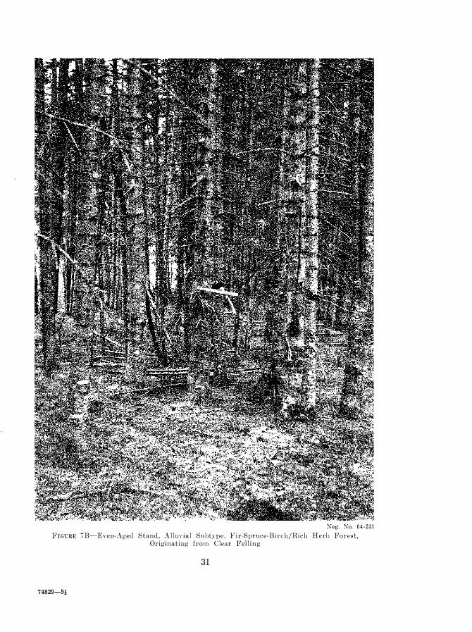
Xeg. :\0. 64-251 FIGCRE 713-EYell-Agecl Stand, A l l U\·ial Suotn)c. F i r-Spruce-13irch/Hich Hero Forest,
Originating from Clear Fel l i n g
31
74829-5!

Neg. No. 64-252
FIGURE 8A---Tndisturbecl Stand, Lower Slope Subtype, Fir-Sprllce-Birch/Rich Herb Forest.
Neg. No. 64-253
FIG nn: 8B-E\'cn-�'1gc(j St and, LmH'r Slope Subt:qle, Fir-Spruce-Birch/Rich Herb Stand, Or iginating from ·Windfall .
32
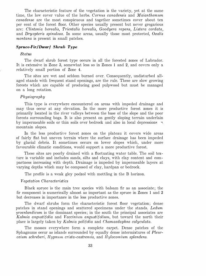
The characteristic feature of the vegetation is the variety, yet at the same time, the low cover value of the herbs. Cornus canadensis and Maianthemum canadense are the most conspicuous and together sometimes cover about ten per cent of the forest floor. Other species usually present but never gregarious are : Clintonia borealis, Trientalis borealis, Goodyera repens, Listera cordata, and DrY'opteris spinulosa. In some areas, usually those most protected, Oxalis montana is present in small patches.
Spruce-Fir/Dwarf Shrub Type
Status
The dwarf shrub forest type occurs in all the forested zones of Labrador. It is extensive in Zone 3, somewhat less so in Zones 1 and 2, and covers only a relatively small portion of Zone 4.
The sites are wet and seldom burned over. Consequently, undisturbed allaged stands with frequent stand openings, are the rule. These are slow growing forests which are capable of producing good pulpwood but must be managed on a long rotation.
Physiography
This type is everywhere encountered on areas with impeded drainage and may thus occur at any elevation. In the more productive forest zones it is primarily located in the riYer valleys between the base of the slope and the poor forests surrounding bogs. It is also present on gently sloping terrain underlain by impermeable soils or thin soils over bedrock and also in local depression� '1 mountain slopes.
In the less productiy€ forest zones on the plateau it covers wide areas of fairly flat but uneven terrain where the surface drainage has been impeded by glacial debris. It sometimes occurs on lower slopes which , under more favourable climatic conditions, would support a more productive forest.
These sites are poorly drained with a fluctuating water table. The soil texture is variable and includes sands, silts and clays, with clay content and compactness increasing with depth. Drainage is impeded by impermeable layers at varying depths which may be composed of clay, hardpan or bedrock.
The profile is a weak gley podzol with mottling in the B horizon.
Vegetation Characteristics
Black spruce is the main tree species with balsam fir as an associate ; the fir component is numerically almost as important as the spruce in Zones 1 and 2 but decreases in importance in the less productive zones.
The dwarf shrubs form the characteristic forest floor vegetation ; dense patches in stand openings and scattered specimens under the stands. Ledum groenlandicum is the dominant species ; in the south the principal associates are Kal1nia ang1l.stijolia and Vaccini1l1n angllstijoliwn, but toward the north their place is largely taken by Kalmia polifolia and Chamaedaphne calyculata.
The mosses e\'ery,,,here form a complete carpet. Dense patches of the Sphagnums occur as islands surrounded by equally dense intermixtures of PleurOZlum schreberi, Hypnwn crista-castrensis, and Hylocomium splendens.
33

"'eg. No. 64 -254 FIGUlE 9A-t"lldi stm·bed �Jll"llce-F i r / D ',",ll·f Shl"llb Type.
;\;eg. ;\;0. 64-255 }-'l{; CRE DH--·-Fj re�ol' igin �tal ld of the � P l'll{'() �Fil' / D ,,· arf �hrllb Type.
34

Neg. No. 64-256 FIGt:RE lO_\-Undisturbed Spruce Sphagnum Type ( Zone 1 ) .
35

Neg. No. 64-257
FIGURE lOB-Undisturbed Spruce/Sphagnum Type (Zone 4 ) .
Herbs are rare and have no cover value ; they consist principally of single specimens of Comus canadensis, PY1'ola secunda and Rubus chamaemorus.
Spruce/Sphagnum Type
Status
This is non-productive forest that occurs throughout all the forested zones of Labrador but northward it covers an increasingly greater area. This type differs from the others in that there is no appreciable vegetative change toward the north ; regardless of where the type occurs the tree sizes, the volumes per acre, and the species composition of the stand remains approximately the same. This suggests that soil factors rather than climate limit tree growth here.
Physiography
The type is restricted to very poorly drained areas on flat terrain. In the richer forest zones it is normally confined to the margins of open bogs but in the less productive zones, especially on the inland plateau, it sometimes stretches for endless miles although the pattern is continuously broken by open boglands and low drier ridges,
The ground water table is at or near the surface of these sites throughout most of the year. The soil is a silty sandy gley overlain by a thick, slightly dccomposed organic mat and the parent material varies from sand to clay with depth.
36

Vegetation Characteristics
Black spruce is the principal tree species ; balsam fir is usually present but is never abundant. These forests are always sparsely stocked to merchantable trees and the individual trees have a peculiar "scraggly" appearance which accentuates this understocking.
The dwarf shrubs consisting of Ledum groenlandicum, Chamaedaphne calyculata, and Kalmia polilolia, form a uniform but not a dense layer. Taller shrubs are rare. Moisture-loving plants such as Rubus chamaemorus, E quisetum arvense, and various Cyperacea, are always present but have slight cover value.
The dense thick moss layer is composed of various Sphagnum species with a considerable intermixture of Pleurozium schreberi.
37

FOREST PRODUCTIVITY
The fundamental requirements for constructing yield tables to demonstrate long term forest productivity are : a site classification, normally stocked stands, and a proper distribution of age classes. The first two requirements can usually be found, but a proper distribution of age-classes can present difficulties. Evenaged stands are those in which all trees have a common chronological origin and this can only result from the death or removal of the parent trees by clear felling, windfall, insect damage, or fire. In this region clear felling has been negligible and what little has occurred has been in recent years; there is no evidence of insect damage ; windfall does occur but usually in small patches and seldom is the entire stand removed. Consequently most even-aged forest has originated from fire and although burning has been considerable and widespread the pattern has not been conducive to a normal age distribution. Forest fires in Labrador appear to be closely related to longterm climatic cycles; an extremely dry year can result in tremendous conflagrations, but then long periods can pass without another maj or fire. There is evidence that severe fire years occur at 80 to 100 year intervals. One such occurred in 1959, another in 1 870, and a third at approximately 1 760. These periodic large fires haye in effect wiped out the pattern of many smaller ones that may have occurred in the interim with the result that in most regions only two or three age classes are to be observed. Practically all else is virgin forest.
The difficulties of age class distribution haye precluded the construction of normal yield tables and necessitated a search for other means of estimating growth. The method of complete stem analysis was selected as being most satisfactory in that the past development of the forest in height, diameter and form can be determined with considerable accuracy from few measurements. The method is time consuming and laborious with the further disadyantage that growth is determined for indiyidual trees rather than forest stands. Bowenr, when used in conjunction with stand-table proj ection the stem analysis method is considered reasonably accurate for short periods of prediction.
In the development of a site index, as isith growth estimation, the age-class distribution of the stands presented a problem. Stem analysis was again found useful; this time for the construction of natural site index CHryes.
Forest Site Index
The relative productivity of forest types is expressed by sile indices and these indices correspond to the three site classes under 'which all forest types han' been grouped. This regrouping is re-empbasized in Table 1 where it is shown that Site I Class is identified \vith the rich herb type only , wbereas Site Classes II and III are each associated with two forest types.
The basic data for age-height relationship, to demonstrate site differences. \vere obtained from conventional stem analysis of a number of trees taken from the different forest types of all the forest zones. In all a total of 285 dominant
38

TABLE 4-PLOT SA�ll'LIXG BY FOREST ZOXER,
FOHEST TYPES AXD RITE CLASSES
Xumuer of Plots ( Al l Age Classes) Forest 'l\'pe Site
.. .. _ -_. ! Class honp 1 ! hone 2
------�.--�- - .--.
Spruce /Lichen . I I I 40 20 Spruce-fir /fea t Iwrmoss I I IiO 20 Fir-spruce-hir('h /ri('h herb . I 8:3 :30 Spruce-fir I d\Yarf shrub . I I .J() 20 Spruce/Splmgllum . I I I 20 ]()
hone :3 - .
__ .
] 0 20 -20 ] 0
hone 4 Total
GO no 20 2:)0 - 1 1 :3 ·10 ] 20 80 ] 20
and co-dominant trees \\'eTe felled and sectioned. In the initial analysis a large number \yere discarded because they shOl\'ed cyidence of suppression or they were not obtained from fully-stocked stands. The final analysis was based upon 120 black spruce and halsam fir t rees distrilmted t hroughout the forest zones as foIl0l\'8 :
Forest Zone Site I
12 2 1 1 3 4
Total 23
Site I I
34 1 1
9 12 66
Site III -- _."---- _._-_.-
9 7
15 3 1
.----��-.--.
Total
5,'; 29
9 27
120
In complete stem analysis each tree :vields age-height IlWnSnH'llwnt" equal to the number of decades the t ree has been growing. Conseq\lently 1 20 tn'c,.: prod\lced approximately 1 ,200 age-height ::;alllples.
A preliminary analysis indicated that for a giyc'n age class and site there was no more yariation in height grOlyth Iwbyeen black ::;pruce and balsam fir th an within one of' the "jll'cie::; ; datn from hoth species \\'C']'(' therefore combined to produce one site index chart.
The height-age relationship::; i )('bwen the different forest zones arc shoml in Figure 1 1 . To produce this graph the data for all the "itcs within a ZOIll' \,"ere combined and \I'eightccl. TheO'c curY('s t herefore ::;hOl\" the lwight-age of the nyeragc or medium "ite of each zone.
The technique used for construction of the natural site index cun-es shown in Figure 12 \\'W3 that described by Spurr ( 1 9;')2 1 . Ages at breast height were usee! to eliminate the initial 8uppres:3ion occurring in man:,-' t rec::: . The site index chart \I'as constructed only for Forest Zone 1 because this was the only zone from \\"hieh sufficient "telll analy"is data had been obtained for reliability. Thc site index for other zones may be found approximately by reducing the indic('� of this chart in prop()rtion t o the ayerngc yalnes SI1O\l'n in Figure 1 1 .
Table ;) giyes t he �tat istical background for the different site cla:3ses at an index age of 50 years at hreast height. At this age the yariation of mean height between sites is approximately t en feet . The variat ion of site index \I'ithin a
39

60
50 zone I
.,
Q) zone 2
11. z o n e 3
c: Z o n e 4 30
.r::
20 '"
Q)
I 1 0
O+-----��----�------�----�r-----_±�----�----��----��---30 40 50 60 70 80 90 100 1 1 0
A g e i n Y e a r s ( b r e a s t h e i g h t )
FrGrim l l -Height-Age Relationships ( A l l RitC's) Bl ack Spruce and Balsam Fir in Labrador.
given site is yery small as indicated by a low standard error and coefficient of \-ariation. A t-test showed the differences between mean site indices of site elasses to be very highly significant. These facts indicate that, insofar as personal bias of selection or rejection of sample trees will allow, the site classification is based upon sound principles.
Forest Zone and Forest Type Voium·es
The ultimate aim of any forest suryey must be the collection of forest statistics which can be assimilated into management plans; this is usually provided in the form of stand and stock tables together with growth predictions. Labrador coyers a vast area and although the forest has been stratified into zones and types, the illustrations of volume and growth must be of a general nature. Such data are useful to industry in the initial planning stage but should not be used as � basis for detailed forest management.
Throughout this study the emphasis has heen placed upon the rich and accessible Forest Zone 1 for the reason that it is the most interesting portion of the country ; it was consequently more intensely sampled. Volume tables for the different forest types ,,-ithin this zone were prepared from complete stem analysis whereas for other zones they were prepared simply as local tables based upon Departmental Form-Class Volume Tables (Anon. 1948) .
,,-ithin forest types emphasis has been placed upon all-aged virgin stands. These are probably more indicative of the productive capacity of the site, as measured by number of stems or basal area per acre, than is any particular age
40

IV IV L
TABLE 5-STATISTICS FOR SITE CLASSES
ZO:\E 1
Site I Statistics
Site Index-Feet*
Mean . 40 . 9 29 . 8
Minimum . . :)0 . 0 2;) . 0
J\faxiIllum . .J\) . O ;)8 . 0
Standard Deviation . 5 . 5 4 . 0
Standard Error of Mean . 1 . 6 0 . 6
Coefficient o f Variation % . 1:3 . 4 j ;) . 4
*Total height at b.h. age of 50 years.
70
60
C 40
f-
3
0
c
0>
V 2
0
r:
1
0
Site III
20 .(J
1 7 . 0
2G . O
:L 5
1 . 2
1 6 . 7
Site I
Site 2
},,"
°3�0�-----;4
0t-----�5±0�----�6
�0------�7±0�----�8tO�-----90�------1�0�0-------I�IO-
A g e i n Y e a r s ( b r e a s t h e i g h t )
FIGURE 12-Site Index Chart for Black Spruce and Balsam Fir.
4 1

class. For the all-aged forest an attempt will be made to show the relative productivity of forest types throughout the different zones and, on the basis of more intensive sampling in Zone 1, to correlate yolumetric data to that of the evenaged forest. In the grolYt!l data to follo\\", it \yii l be assumed that the approximate rotation age of an eyen-aged forest is t hat age \yhen the merchantable volume of the stand is slightly greater than that of the all-aged forest.
Table 6 is a summary of the data for undisturbed all-aged forest. Notable i s the fact that total number of stems per acre does not vary greatly between forest zones or forest types. On the other hand, both basal area and merchantable volume shows a definite trend which is relative to the forest zones and to the forest types with in the different zonc,". This trend, ! l mycyer, is greatly reduced in thc poorer types of the poorer zones.
TABLE G-:\IK',SCRATIO:,\AL DATA FOR ALL-AGED STA;'\DS 0:'\ A PER ACRE: BASIS BY FOREST zmms AND FOREST TYPES
;'\umher of Trees I Basal Area, Sq. Ft. I Softwood All Species All Species Merchantable
FOf('st Type ------------ -- ---------- Volumet
! ?-.Ierchant- Merchant- Cubit, ________________
I�'otal=_. I--ta-. b_l_e*,'_* _ _ l_'_otal=_. __
a __ b_l_e*_* ___
I ___
F_ee_t __
ZONJ<; 1 I A. Fir-Sprllcc-Bireh/Rich I
Herb . 1 , :)7 5
B . Spruce-Fir/Feather mOSfi . , 1 , 4 10
C. Spruce-Fir/Dwarf Shrub , . 1 , :385
D. Sprucc/Sphap;nuI1l , 1 , G50
5\)5
590
680
455
1 85 1 08
1 42 1 24
1 49
64
Basal Area, Sq. Ft. All Species
Fo]'('st Type:
1\ ' N umber of Trees All Species
---- ------------,
I 'I ?-.Ierchant- Merchant-Total* table** Total' able*'
------------ ---- 1---- \------' '-- -,----
ZOl\J<; 2 I A. Fir-Spruce-Birch/Rich I
Herb . 1 , 1 45 I B. Spruec-Fir/Feathprmoss .
C. Spruce-Fir/Dwarf Shrub , .
D . Spruce /Sphagnum , '
1 , ;370 I
1 , :3()0
II , \ 1 , a80
* All trees 0.6" and over at breast height. ** All trees a.(j" and over at breast height. tTrees 3.6" and over at. breast height.
42
570 1 7 5 1 00
400 1 05 HO
525 1 1 5 100
aoo 60 1 5
3 , 260
1 , 960
2 , 050
700
Softwood Merchantable Volumct Cubic Feet
1 , 950
1 , :380
1 , 420
490

TABLE fi-Coneluded
I Xumber of Trees I Basal Ar;a, Sq. Ft. I Softwood . All SpccIes I All 8pecIes :Vfe�('hantable
Forest Type ---
-I�\ICrchant::-- I
---
-
I--\ICrchant::-- I! \i gl�I:7��t _ ____ __________ �
13�tal*
I
I
--ttlble*:-- i �'otal*
I--'hl""---
I-
Fe'" _
A. Fir-8pl'llcc-BirchjWcl! I I ZO:-!J<] :j [
Herb ! I ! I B . SpnwC'"Fir /lieathermoss . 1 , 2G() I G80 H2 I C. 8pnl('e-FirjD\\,arf 8hrub . 1 , 5-10
'
-1-10 n:j [I D. 8prucejSphagnum . . . i 1 , G\l0 -120 n
77
!JOO
-1U 370
I Xumber of Trees II Basal Area , Sq. Ft. I' Softwood All Species All Species :\Ierchantable 1----------- ·------·---1 Volumd
, I :\lerchant- I :\Ierchant- Cubic _._______________ _'I_'o_t_al_'_ I __ t_a_b_le_'*�_-I_c_r_otal =- _�lbl_c*_* _ ___
F_e(_�t __ _
Zox]<] -1.
. I A. Fir-Sprucc-Birchjltich
Hc'rh .
B. Spl'tH·e-FirjFcathcrmoss .
C. Spl'llcC'-FirjD\\'arf Shrub .
D . :-::Pl'lH'('j:-::plmp;nulll .
I , :3-10
1 , .J-10
1 , toO
* All t n'('s (Ui" and oV('r at bre:l st jl('ip;ht . **AII trees :U;" and over at breast Il('ip;hi . tTrc('s :t(i" and over at l)]'(�ast h('ight.
G50
-170
I I I
85 (i5 7G5
\)5 75 !JOO
(i5 -15 ;)(iO
l\Iensurational ed illlates of unenn-aged forest stands giye a measure of the crop which may be han-ested but does not t ake into account the time clell1eEt necest'ary to produce t his cro p . Volume or yield must be measured by the years necessary to produce i t and this can only be determined for e\'en-aged stands .
The cH'n -aged fo]'e�t diffl'l's ,yidcly from the all-agee! forest in many as]lects nnd particularly in respect to �taJ1(1 clcn,;ity. On the ha�is of total trees or basal area per acre the ('yen-aged forests arc demer and this density pattern changes ,yith time ; this is in contrast to thc al l - aged forest \yhere stand. density may be considered as a constant . These trends of st and density pattern on the basis of stems ]leI' acre are shmm in Figure 13 for Sites I and II in Zone 1. The number of trees per acre are at a m in imum at one or tvyO decades past the rotation age and are then ap]lroximately' equ a l to the number carried on an undisturbed stand on a similar site. Beyond this stage the number of trees again increases
43

3000
Q)
u <f 2500
Q) 0- I '" I E 2000 I Q) I
(/) I /
/ 0 1 500 0
I-
1000)+---------+---------�--------�------�--------_±�------� 50 75 100 125 1 50 175 200
To t o l A g e i n Yea r s
FIGURE 13-Stand Density Pattern for Even-Aged Stands.
rapidly which indicates that the old over-mature ::;tand is breaking up and new trees are fi lling in the openings in the stand; strictly speaking the stand cannot then be considered even-aged.
The black spruce/lichen forest type is an exception to this rule as this is essentially a sparsely stocked forest type.
It will be noted, in the figure just discussed and in subsequent figures and tables pertaining mainly to the characteristics of even-aged forest, that a shift has been made from the term forest type to that of site class. The site classes serve as a convenient method of grouping forest types into classes with rather similar growth characteristics. For exitmple, the very dry spruce/lichen forest and the very wet spruce/sphagnum forest differ greatly in their ecology but as trees growing on these types were found to have approximately the same growth rate and form, they were grouped together into Site Class III for the purpose of volume and growth predictions. Similarly the dry feathermoss and the wet dwarf shrub forest types were grouped to form the Site II Class. In the all-aged forest the species composition and stand density may differ in these types within a site class and consequently stand and stock titbles must be shown separately. Such differences are not obvious in the even-aged forest and growth trends can best be shown by site classes.
The difficulties encountered in obtaining a proper distribution of even-aged stands -were discussed earlier. As a result of those difficulties it is impossible to give any reliable indication of the yield with age for forest types other than those occurring in Zone 1. EYen in this zone there nre so many missing age classes that only the generitl trend can be indicated. This trend, itS illustritted in Figure 14, slwws that maximum merchantitble volume for Sites I, II and III
44
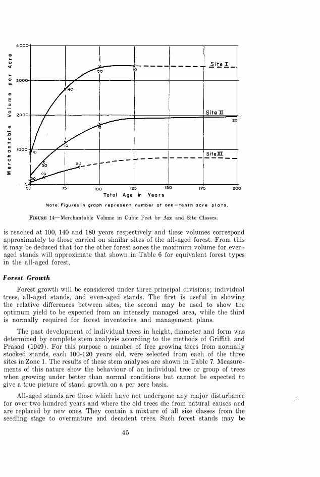
Q) <.> «
Q) 3000 Q.
Q) E ::> 0 >
Q) .0 0 c: 1000 0
� <.> ... Q) :E
75
"-_---1- - - - - _ _ _ _ 10
Site 1I
SiteJII: - - - - - - - - - - - - -
100 125 1 50 Tot o l A g e in Yea r s
175
N ot e : F i g u res in g ro ph r e p r e s e n t nu m b e r of one - te n t h a c r e p l o t s .
FIGURE 1 4-Merchantable Volume in Cubic Feet by Age and Site Classes.
20
200
is reached at 100, 140 and 180 years respectively and these volumes correspond approximately to those carried on similar sites of the all-aged forest. From this it may be deduced that for the other forest zones the maximum volume for evenaged stands will approximate that shown in Table 6 for equivalent forest types in the all-aged forest.
Forest Growth
Forest growth will be considered under three principal divisions ; individual trees, all-aged stands, and even-aged stands. The first is useful in showing the relative differences between sites, the second may be used to show the optimum yield to be expected from an intensely managed area, while the third is normally required for forest inventories and management plans.
The past development of individual trees in height, diameter and form was determined by complete stem analysis according to the methods of Griffith and Prasad ( 1949 ) . For this purpose a number of free growing trees from normally stocked stands, each 100-120 years old, were selected from each of the three sites in Zone 1 . The results of these stem analyses are shown in Table 7. Measurements of this nature show the behaviour of an individual tree or group of trees when growing under better than normal conditions but cannot be expected to give a true picture of stand growth on a per acre basis.
All-aged stands are those which have not undergone any maj or disturbance for over two hundred years and where the old trees die from natural causes and are replaced by new ones. They contain a mixture of all size classes from the seedling stage to overmature and decadent trees. Such forest stands may be
45

TABLE 7-GROWTH OF TREES IN SIZE AND FOR:'.! BASED UPON STE:\! ANALYSIS
FORI<�ST ZO"E I
(Blaek Spruee and Balsam Fir)
I [ I II Volume I , Diameter , Height I Age Cubic Feet I Form I 1 tlehc8 Feet Years 1 ( :\Ip!'chantablc) Class
SITE
-
I
---- -- ! - - -!! - - - :1- --1- : � - H --
7 52 (\5 8 56 76 \J 58 88 10 5H 105
5 . 2 7 . 7
I O . -! 1 ;) , 4
(\0 (\2 G:{ (i5
-----
- -------- ----------�-----SITE I I
4 :30 5 ;·Hi (\ 40 7 4:3
------
SITE I I I 4 22 5 2G (j :H
44 (\5 no
1 15
50 Gfi
I O()
0 . 7 1 . (\ :3 . 0 4 . 6
0 . 6 1. 2 2 . -1
60 62 6-1 64
62 (i:-{ G4
considered as being in a state of equilibrium where annual growth is balanced by annual mortality : they arc characterized by a complete absence of any short-term growth cycle. Although such stands do not show a net increase they do provide a good method of measuring growth potential . The gross annual increment of volume may be considered as the amount that could be cut yearly if the stands were managed on a selection system. This gross increment has been determined by applying the diameter increment, for a ten year period, from the individual tree study to al l-aged stands using the stand table proj ection method of Spurr ( 19,52 ) . The results for Fore8t Zone 1 arc as follows :
Fores! T�'pe
Gross Annual MnehantablC' Site Increm€'nt in Cubic Feet
ClaS:l Per Acre .-------�-----.. ----
Fir-Spwcc-Birch/Rieh Hcrb Spruc€'-Fir/Feathermoss Sprucc-Fir/Dv'iarf Shmb Spruce/Sphagnum
I II II
III
108 42 48 16
.. _--_._-_._ -... -----_.-._._-_.----
"'hile individual trees and uneven-aged stands can provide rela ti " e information pertaining to the productive capacity of the site, it is only the even-aged stands which permit the measurement of net production of \Yood on an area basis
46
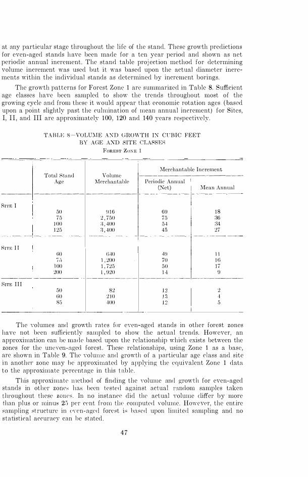
at any particular stage throughout the l i fe of the stand. These growth predictions for even-aged stands have been made for a ten year period and shown as net periodic annual increment. The stand table proj ection method for determining volume increment was used but it was based upon the actual diameter increments within the individual stands as determined by increment borings.
The growth patterns for Forest Zone 1 are summarized in Table 8. Sufficient age classes have been sampled to show the trends throughout most of the growing cycle and from these it would appear that economic rotation ages ( based upon a point slightly past the culmination of mean annual increment) for Sites, I, I I , and III are approximately 100 , 120 and 140 years respectiyely.
TABLE 8-VOLU:\1E AXD UROWTH IX Cl'BIC FEET BY AGE AXD SITE GLAf'SER
Total Stand Age
FOREST ZO:\E 1
Merchantable Increment Volume ---- ---------�-----�---------
l\l<?rchantablp Periodic Annual (Net) Mean Annual
----- --------_. --------- ---------- -----------
Rl'rIC I
SIn� I I
50 75
IOO 1 25
(iO
J OO 200
\) 10 2 , 750 :i , 400 :j , 400
(i.jO 1 , 2()0 1 , 725 I , H20
09 18 75 :10 54 :)4 4,'> 27
1!l 1 1 70 Hi 50 1 7 1 4 ()
---------- 1 ---------------_·_- -----.----.. --.. - -----------.--- ---.--------RITE II I
50 (i0 85
82 2 J O 400
2 4 5
The yolumes and growth rates for eyen-aged stands in other forest zones have not been sufficiently sampled to 8hmv the actual trends. However, an approximation can be made based upon the relationship which exists between the zones for the ulll" 'en-agec! forest. These relationships, using Zone 1 as a base, are shown in Table 9. The yoluJlle and growth of a particular age c lass and site in anoth('1' zone may be approximated by applying the equivalent Zone 1 data to the approximate percentage in this t able .
This approximate Jllethod of finding the yolume and growth for even-aged stands in other zonc>' has been tested against actual mnc!om samples taken throughout these Z O ll C S . In no instancc did the actual volume cliffer by more than plus or minu" 2;j pcr ccnt from tIl(' computed ,"olume. HmH'vpr, the ent,ire sampiing st ructure in " " cn-aged forest i.� based upon limited sampling and no statistical accuracy can he stated .
47

TABLE 9-MERCHANTABLE VOLUME RELATIONSHIP BETWEEN FOREST ZONES ALL-AGED FOREST
Site Class
Forest Zone 1
Forest Zone 2
Forest Zone 3
---�-- ------�--------------------
Percentage of Merchantable Volume
I 100 GO
I I 1 00 70 46
I I I 1 00 70 53
48
Forest Zone 4
42
50

Black Spruce
GENERAL SILVICAL CHARACTERISTICS OF
LABRADOR COMMERCIAL SPECIES
Black spruce is the most abundant commercial tree and probably constitutes about seventy per cent of the forest. Its range extends from the southern boundary north to Napartok Bay in latitude 57° 50'.
It is usually the main constituent of undisturbed forests and its occurrence varies with site : on both the extreme wet and the extreme dry sites it is found usually in pure stands, on the wet and dry sites it occurs in equal admixture with balsam fir, and it rarely invades the rich moist lower slopes and alluvial flats. In the even-aged forests its presence or absence depends entirely upon the kind of disturbance from which the stand originated. After fire, on all sites, it either forms pure stands or grows in admixture with white birch ; it rarely occurs, except as a scattered specimen, in stands resulting from clear felling or windfall.
There is no evidence that flowering and fruiting in Labrador are other than normal for the species although these phenomena occur anywhere from one to three weeks later than in adj acent Newfoundland. Seed crop measurements have not been made but casual observations seem to indicate that total cone production is lighter than normal for the species ; it is sufficient however to produce dense stands on most sites after fire.
Vegetation reproduction by "layering", which is a well known characteristic of black spruce, is the usual method of propagation for the species in other than fire origin stands and accounts for over 95 per cent of all advance growth. Other than the characteristic "butt sweep" of layer origin trees there is no indication that this method of propagation results in inferior specimens.
Black spruce is considered a slow growing species and in Labrador the growth rate is slower than normal. It varies considerably, however, between sites and with competition. Under ideal conditions trees may reach breast height in ten years or less but under adverse conditions it frequently takes fifty or more years to attain this height. The largest tree measured was 18 inches in diameter at breast height and was 73 feet tall. It is a fairly long-lived species and ages in excess of 200 years are common. The oldest sound tree recorded was 260 years at the stump.
The species has a shallow widespread root system and thus is susceptible to windthrow. On a lichen site a lateral root growing in the top inch of the mineral soil was traced 35 feet from the base of a twenty foot tree.
In Labrador black spruce has remarkably few enemies of a biological nature which would limit its growth. No insect enemy v<;as noted and the external diseases are confined to very minor and sporadic attacks of needle rusts of the
49

Chrysomyxa species. Wood destroying fungi are common ; of these those producing butt rots occur most frequently. In the overall sampling approximately fifteen per cent of the mercantable trees were found to be defective at stump height but less than one per cent at breast height.
Because of the slow growth rate , Labrador black spruce is considered an ideal pulpwood species ; the average basic specific gravity is 0.44 as compared with a normal of 0.40 for the species elsewhere in Canada. In effect this means that for equal yolume this black spruce will yield ten per cent more weight than normal.
Ralsam Fir
Balsam fir is next to black spruce in abundance and constitutes about 25 per cent of the forest. It is widespread in southern Labrador but north from approximately the 54 ° latitude line it decreases rapidly in abundance. It does not extend quite as far north as the spruces, and at the northern extremities of its range it is found only on the best soils.
In the virgin furest of southern Labrador its occurrence varies with site: on the good sites it is dominant, gr()\ying in association with white spruce and white birch ; on the medium sites, both wet and dry it occurs in about equal proportion with black spruce ; on the poor sites, both the extreme wet and extreme dry , it is a minor component with black spruce. l\Ioving northward its dominance in better stands is slowly taken oYer by hlack spruce. Stands resulting from either clear felling or windfall are normally fir while in fire origin stands it is rarely found.
ObselTations made over it four year period showed good seed crops occurring every two to four years with cone ripming varying anywhere from the first to the twentieth of September.
In mature and all-aged st ands, on medium and good sites, there is Ui:iUally a continuous layer of fir adyance growth ,yhich should result in another fir crop ,yith any type of cutting. Dense immature stands normally cannot support advance growth and rnay not rep]"()duce after cutting. Layering does occur but is not an important means of regeneration.
The average growth rate of bal:sam fir 1 :0' similar to that of black spruce, but fir is more variable than any other species. In fairly open stands on good sites the growth rate can Jll' phenomenal while in \'ery dense stands it may be barely perceptible. Breast height may be reaehed by fanJUred seedlings in six to eight years while otherl:), growing under particularly ach·erse conditions, may require sixty years to obtain this height. The largest tree measured was 19 inches in diameter at breast height and ,\·as 79 fed tall. The oldest sound tree recorded ,yas 220 years at the stump.
This species normally has a thin bark but occasional trees may be encountered on all sites with 11 cork-like bark extending up to byo inches in thickness. On some trees this extends o\"er the entire hole, on others it is present in narrmy bands on thl' Imwr trunk. Xo :,;atisfactol")' explanation can be given for thi" phenomenon.
!)O

Fir has a shallow root system and is susceptible to windthrow. No insect memies were noted. Decay-causing fungi are prevalent and thirty per cent of ;he sampled trees contained butt rot ; ten per cent showed defect at breast height. t\.ll defective trees were older than fifty years.
The Labrador balsam fir is a good pulpwood tree which on a unit basis will rield somewhat more pulp than normal. The average basic specific gravity of �abrador fir is 0.34 and the normal for the species is 0.33.
White Spruce
White spruce is not abundant and constitutes less than five per cent of the ·orest. Its range coincides very closely with that of black spruce but goes ,lightly farther north.
In southern Labrador the species never forms pure stands but exists as a ninor constituent in balsam fir and white birch stands in the undisturbed forest )ll good sites. In the north it also prefers such sites but in addition Hustich ( 1954) has reported it from the Knob Lake area "in seemingly poorer habitats, )ften forming white spruce lichen heaths". He attributes the affinity for these Doorer habitats to the influence of a sedimentary bedrock composed of dolomites ;md shales. It is noteworthy that the species is not present further south around i\shuanipi Lake which is an area of nutrient-poor sedimentaries.
The dates for flowering and fruiting vary with latitude and occur slightly 2arlier than black spruce. Seed production appears to be about normal for the species. Over a four year period one good crop, two light crops and one almost lotal failure occurred.
Although fair quantities of seed are available, the germination and survival )f seedlings appears to be poor. White spruce accounts for less than one per cent of the total advance growth in all-aged stands on the good sites. Those few ;;eedlings which do occur are normally found in stand openings. Vegetative reproduction through layering was not observed.
\Vhite spruce is the fastest growing; commercial species of Labrador and indi\'idual trees were recorded grovving at the rate of 2.5 inches in diameter in ten years. Initial height growth is fairly good and, although suppression is sometimes a factor, breast height can usually be reached in ten to fifteen years. The largest tree encountered measured 37 inches in diameter and 105 feet in height. The oldest tree recorded was 200 years at the stump but much older trees are in evidence.
This species has a fairly deep root system and is surprisingly wind-firm. Not a single uprooted tree was noted although many large trees were broken off, usually about tC'D feet from the ground.
No insect enemy of white spruce was observed but minor infestations of needle rusts vvere fairly common. The living tree appears to be devoid of woodrotting fungi and not a single instance of attack on standing trees was noted.
Because of its large size, its lightness, toughness, and cleavage characteristics, white spruce has been exploited more than any other species. It is a popular lumber tree and since time immemorial the aborigine population has been utilizing it to proyide the framework in the construction of canoes.
51

Eastern Larch
Eastern larch occurs only as a scattered tree and its proportion of total forest cover is negligible. In the rich forest zones of southern Labrador it has a very limited distribution but the species increases proportionately with increasing latitude. It is considered the hardiest of the northern conifers and is supposed to exist as a tree to the very margin of the northern forest where the black spruce is dwarfed to a mere shrub.
In the southern lowlands it is confined to the poorer sites and grows as a minor constituent with black spruce on both wet peat swamps and dry lichen sands ; further north it may be found on any site but the very best. It occurs in both the undisturbed forest and in fire origin stands. Larch is rated as very intolerant and in this region its presence is characteristic of an understocked stand.
No studies were made of seeding characteristics but casual observations indicate a good seed crop at least every four years. Trees were noted bearing cones at the age of twenty years. Vegetative reproduction by layering does occur but it is not a common means of regeneration.
Eastern larch is not a commercial tree. It is slow growing, small in size, and somewhat deformed. The largest tree recorded was seven inches in diameter at breast height.
No insect enemy or disease was noted as being presently active but there is every indication that a serious epidemic of larch saw fly (Lygaeonematus euchsonii) occurred about the turn of the century. Trees older than sixty years are not to be found whereas old larch snags on bogs indicate that older trees once existed. The survey of Low ( 1896) shows the species to have been much more prevalent then than now. In part he says "It grows everywhere throughout the Labrador Peninsula, and is probably next in abundance to black spruce. Throughout the interior it is found growing in all the cold swamps and is always the largest tree in the vicinity. The larch of the southern region (Quebec Labrador) has been almost totally destroyed by the ravages of the European larch saw fly. The present range of the pest extends northward from Lake St. John to beyond Lake Mistassini, and appears to be yearly spreading northward and eastward. " It would appear that shortly after the period of Low's report, the insect did reach Newfoundland Labrador and succeeded in almost wiping out the species.
White Birch
White birch is the most prevalent hardwood species but it does not constitute more than one per cent of the total forest cover. It ranges all over the peninsula from the southern boundary north almost up to the tree line, but inland from the coast north of latitude 55 0 , it rarely exists except in a dwarfed form.
White birch is rated as a pioneer species and is one of the first trees to invade an area after fire. In such situations it can form pure stands but more frequently it grows in association with other hardwoods and with black spruce.
52

It is an intolerant tree and in the natural succession usually lasts only one generation and is then replaced by more tolerant species. Its occurrence in the undisturbed forest varies with locality and with site : in the two most productive forest zones it is a common component of the rich balsam fir-white spruce-white birch forest type and it occurs as a widely scattered tree in all other forest types ; in the less productive forest zones its occurrence varies from a scattered tree in the better types to a rare invader oJ the poorer types.
Seed crop observations over a four year period showed three good crops and one complete failure.
White birch is normally a small tree and the average diameter at maturity is from eight to ten inches. However when growing under optimum conditions much larger trees may be produced ; the largest tree recorded measured 18 inches in diameter at breast height.
No insect enemies were noted but the condition termed "birch dieback" is prevalent all over the Peninsula. About ten per cent of all trees are affected but up to 1960 mortality was light.
White birch cannot be considered an important commercial species although some good stands are in existence and individual specimens may be of excellent quality. Normally the trees are many branched with little clear bole and unsuitable for most commercial purposes.
Trembling Asp·en
Trembling aspen is not a prevalent tree and constitutes a negligible proportion of the total tree cover. Its range is more restricted than that of any other species and it is rarely found north of latitude 54 0 or vyest of longitude 640 •
At this northern limit o f its range it seems to favour the warmer soils and grows with greatest abundance on sandy terraces and till slopes with favourable aspects.
Aspen is a pioneer species. It is one of the first trees to colonize burns and it quickly invades landslides, sand dunes and other areas \vith drastically disturbed soils. It rarely forms pure stands but usually grows in association with white birch and frequently occurs as a scattered tree in fire-type spruce stands. Aspen is rated as very intolerant and cannot reproduce under any appreciable degree of shade. It thus holds a temporary place in forest succession and is eventually replaced by more tolerant species ; it \"ias not observed in the undisturbed rorest.
This is a short lived species. In Labrador the growth rate is slower than normal and trees are comparatively small. The largest tree recorded was fourteen inches in diameter at breast height.
Trembling aspen is not a commercial tree in this region but its presence adds immensurably to the intrinsic value of the forest. It is a favoured food of many northern mammals and birds and it gives colour and aesthetic value to the park-like lichen stands.
53

Balsam Poplar
Balsam poplar is numerically the least important tree and its total proportion of forest tree cover is insignificant. The range of the species is not known with any certainty but it is believed to coincide approximately with that of the balsam fir and white birch. It is very irregularly distributed and is entirely absent from many large areas.
Poplar is not a true forest tree here but is one of the first to invade recently deposited soils. It is frequently found growing with alders and willows on low often inundated alluvial river flats, sand bars, stream banks and lake borders ; it sometimes grows in association with black spruce on the drier lichen sites. Usually it occurs as scattered individuals but occasionally it forms small pure stands.
The flowering and fruiting characteristics of the species was not studied but there is no reason to believe that the behaviour is other than normal for the species. Vegetative reproduction by root suckers and stump sprouts is common and is the usual method whereby small stands are formed from scattered trees.
Balsam poplar is neither a large tree nor a well-formed one. The largest tree recorded measured 1 6 inches in diameter at breast height but most mature trees are considerably smaller. They are many branched and with little clear bole.
This species is not of commercial importance and like trembling aspen its value to the region is mainly aesthetic.
54

ECONOMIC POTENTIAL OF LABRADOR FORESTS
Areal Classification of Labrador
Previous chapters haye dealt qualitatively with the vegetative zones, the forest types, and the individual tree species. The remaining task is to produce quantitative estimates of these entities and from them to show the potential of the Labrador forests. Although the provision of such information is necessary to complete the picture it must be realized that these estimates are quite subj ective and no degree of accuracy can be quoted.
The areal extent of the forests, classified according to forest zones and types, is shown in Tables 10 and 1 1 . These tables were produced from the vegetation classification map and from aerial photographs. The areas of the different zones were obtained by planimetering from eight miles to one inch maps. The extent of each forest type within the different zones was allotted on a percentage basis from the interpretation of aerial photographs.
At this stage an estimate of the total volume of merchantable wood in Labrador could easily be made by applying the per acre wood volumes, already determined, to the above tabulated area summaries. However, the presentation of such volumetric data for the entire region would be of academic interest only and could be most misleading. Included in the vegetative classification is Forest Zone 4 which covers a vast area and maintains a low, but nonetheless discernible, per acre merchantable wood volume. Zone 4 is rated as supporting a submarginal and scrub forest which means that although merchantable trees may be present the forest stands themselves are so low in density that the process of harvesting would be uneconomical. This is also true of the unproductive forest types in the merchantable forest zones. To include volumetric summaries for such areas would be unrealistic .
An additional restriction on the value of a total estimate of merchantable wood is the l ack of knowledge of recent fire patterns. The approximate boundaries of some recent fires are shown in Figure 15 ; of particular importance is the large and partially accessible area in the southeastern section which was burned over in 1959. This fire seriously restricted the economic potential of one of the principal forest sections of the country. The boundaries of fires in the interior are either unknown or only approximately mapped and whereas these fires in inaccessible areas have little or no effect on the future economy, they could reduce the accuracy of total wood estimates.
The estimation of the total amount of wood is considered unnecessarv but the amount in the merchantable forest on acce'ssihle watersheds is of prime importance and will be shown . \Vhen referring to the accessible forests of Labrador it is customary to separate the entire region into geographical units consisting of the principal bays and including the watersheds of the rivers flowing into these bays. These separate areas frequently differ in topography, soil s and flver
55

structures ; thus, for a forest industry, they all present different operational problems and could be considered as economic as well as geographic units. The boundaries of the four principal units are shown in Figure 16 . The economic features of each of these will be illustrated and discussed separately.
TABLE lO-LABRADOR AREA CLASSIFICATION
Area by Vegetative Zones
PART I
Vegetative Class
--�----�--------------------'--
-'---
Excellen t Fore�t 'Zone . .
Good Fore8t Zone . _
Marginal and Fair Forest Zone . .
, . . . . . - . . . ,
. . . . . . - . - - -
_ _ _ (Zone 1 )
. . . (Zone 2)
. . . . . . . . . . (Zone 3)
Scrub and Unmerchantable Forest Zone . " . . . . . . . . . (Zone 4)
Arctic and Coastal Tundra Zone .
TOTA L .
PART I I
. . . . . .
. . ' . .
. . . . . .
. . . . . ,
, . . . .
. (Zone 5)
. . . . . . . .
'ZON AI, Cl�ASSIFlCATlON
Thousands of
Acres
528
6 , 286
19 , 819
2 1 , 692
23 , 21 8
7 1 , 543
Per Cent
------
1
9
28
30
32
100
Land Area Inland Waters Forest Zone Thousands of Acres Per Cent Thousftnds of Acres Per Cent
------- _.- --_._---------
--- ----
[----
_._-----
[-------4:-\2 82
5 , 960 95
3 1 8 , 429
4 1 8 , 4 13 I 85
5
I 2 1 , 7 1 G 94
;r(lTA�-'- --- - --�---1-------
U6
326
1 , 3UO
3 , 279
1 , 502
6 , 5\);)
-------------- ----
1 8
5
7
1 5
fj -----
-
Omit ted \\ i l l be a number of small watersheds not belonging to any particular geographical unit. This omission will not alter in any way the general conclusion::: but \yi l l lend conseryatism to the estimates of available wood.
56

I I
\
'\ ,/. . . - . . _ . . -
FIGl"RE 15-Laora<1or Forest F i re Pattern. 1040· 1960. (Approximate areas ) .
57

TABLE l l-FOREST TYPE CLASSIFICATION BY ZONES
Forest Type and Land Class
Spruce /Lichen Type . . .
Spruce-Fir /Feathermoss . . .
Fir-Spruce-Birch/llieh lIerb .
Spruce-Fir/Dwarf Shl'\lb . .
Spruce/Sphagnum . . . .
Bog, Rock and Wasteland .
TOTAL .
Forest Type and Land Class
ZOKE 1 ZOKE 2
Thousands Per Cent Thousands I Per Cent of Acres of Acres
------ ----- ------ -----
88 20 1 , 794 30 . . . . . I ' " . 126
22
29 1 , 41 8 24
5 60 1
81 II) 1 , 180 20
80 1 9 852 1 4
35 8 656 1 1
I-�;;-- ------ -----
100 5 , 960 100
I ___ ZONE 3_' ____ ___ Zo�� __ _
I Thousands Per Cent Thousands Per Cent of Acres of Acres
------------------ ------ ----- _·------ 1------
Spruce /Lichen . 6 , 321 :34 5 , 082 27
Spruce-Fir /Feathermoss . 2 , 322 1:3 1 , 989 1 1
Spruce-Fir /Dwarf Shruh . . . 3 , no 17 2 , 762 1 5
Spruce/Sphagnum . . . . . 3 , 704 20 4 , 529 25
Bog, Rock and vVastcland . 2 , \) 12 1 6 4 , 05 1 22 -- ---- ----- ------ -----
TOTAL . . 18 , 429 100 1 8 , 41 3 100
A lexis Ray
This is the mOc<t southcrly of the Labrador forest operational units. It roYel'S an area of 5 ,800 square mile:,; and includes tbe \yatersheds of the Alexis, the Gilbert, tbe Ha\yk and the St. Lewis riwrs. The coastline extends for about 100 miles in a llorth-south direct ion and contains numerous deep bays and fiords Inland the lane! rises fairly rapidly to tbe leYel of the plateau except where the t opography is broken by the ,-al leys of the numerous rivers and streams ; the terrain is generally ruggerl.
The A.lexis Bay region is the lllO:ot acres:;iblc foreEted area of Labrador and from 1934 to 1942 was t he centre of the only continuous large scale forest operation so far carried out \yithin the t erritory. I ts principal acl\-antages are : a
.18

L E G E N D A l e x i s B o y . . . . . . . . · · . . . . . . . 1 Sandwich B o y . . . . . . . . . . . . . . . 2 Lake M e lv i l l e . . . . . . . . . . . . . . . 3 K a i pokak Boy . . . . . . . . . . . . . . . 4
FIGCRE 16-�l'rillcipal Econom ic FOJ'c,t D i Y i ,ions of Labrador.
59

southerly location and the relative nearness to markets ; excellent shipping ports ; good driving rivers ; and a small semi-experienced labour force. The main disadvantages are : an exceedingly rugged and rocky terrain whici"l greatly increases the difficulties of road building and transportation ; the recent destruction by fire of large areas of good accessible forest ; and the diffuse nature of the forests which are contained in numerous large and small watersheds scattered over 100 miles of coastline.
The most serious detriment to large scale long term forest operations in this area is the destruction by the fires of 1959. These large burnt areas, situated as they are across the valleys of all the large rivers, have drastically reduced the area of good forest. From Table 12 , which illustrates the area classification, it can be determined that while thirteen per cent of the total land area was burnt over, no less than fifty-eight per cent of this burn occurred within the Good Forest Zone.
TABLE 1 2 --AREA CLASSIFICATION BY FOREST ZONES
ALEXIS BAY UNIT
(Area in Thousands of Acres)
Forest Zone
Good . . . . . . . . . . . . . . . . . . . . . (Zone 2)
Fair . . . . . . . . . . . . . . . . . . . . . . (Zone 3)
Submarginal . . . . . . . . . ' . . . . (Zone 4)
Tundra . . . . . . . . . . . . . . .
TOTAL . . . . .
. . . (Zone 5)
. . . . . . , .
Land Area
Undamaged Burnt
1 , 169 259
1 , 324 160
260 1 8
293 9
3 , 046 446
Water Total Area
1 , 428 94
1 , 484 79
278 28
302 1 3
3 , 492 2 1 4
Total Area
1 , 522
1 , 563
306
3 1 5
3 , 706
The area of presently productive forest land and the volume of available wood is shown in Table 13. Not included in these estimates are the substantial volumes present in the merchantable forest types of the submarginal forest zone and also the volumes which could be harvested from the unproductive forest types of the better forest zones.
The cords per acre estimates, shown in Table 1 3 and all subsequent tables, are derived from the merchantable volumes for all-aged stands given in Table 6 . This derivation is based upon the assumption that in each forest type half the stands will be all-aged and the remaining half will be composed of about equal proportions of age classes from the seedling stage up to maturity. The volume per acre thus assumed is equal to seyenty-five per cent of the merchantable volume present in uneven-aged stands.
Although sufficient wood is present to sustain large-scale cutting operations the Alexis Bay region appears to be one of the least attractive areas of Labrador
60

TABLE 13-AREA AND VOLUME SUMMARY
ALEXIS BAY UNIT BY PRODUCTIVE FOREST ZONES AND FOREST TYPES
Forest Type
ZONE 2
Spruce-Fir /Feathermoss . . . . . . . . . . . . . . . . . . . .
Fir-SprucecBirch/Rich Herb . . . . . . . . . . . . . . . . .
Spruce-Fir /Dwarf 8hrub . . . . . . . . . . . . . . . . . . . .
TOTAL . . . . . ---
ZONE 3
. . . . . . . . . . . . . . . . . . . . . . .
Spruce-Fir /Feathermoss . . . . . . . . . . . . . . . . . . . .
Spruce-Fir/Dwarf Shrub . . . . . . . . . . . . . . . . . . . .
TOTAL . . . . . . . . . . . . . . . . . . . . .
TOTAL ALL ZONES . . . . . . . . . . .
. . . . . . .
. . . . . . .
Total Area in Cords Per Volllme in
Thousands Acre All Thousands of Acres Age Classes of Cords
278 12 . 0 3 , 336
12 1 6 . 0 192
23 1 1 2 . 5 2 , 887 �
521 6 , 415 ---- -
167 8 . 0 1 , 336
228 8 . 0 1 , 824
3U5 3 , 160
9 1 6 9 , 575
for a maj or forest industry. Such an undertaking would have to be decentralized into a number of small operations conducted in numerous bays and fiords with a subsequent increase in operational overhead and a substantial rise in the cost of transporting the raw material to a manufacturing centre.
This is probably a good region for a number of small forest industries, each operating in one bay and shipping its produce in the unmanufactured state or semi-processing it into pulp or wood chips before shipment.
Sandwich Bay
The Sandwich Bay Unit is situated immediately to the north of and is partially bounded by the Alexis Bay region. The coastal section consists principally of Sandwich Bay which is a fairly wide and sheltered body of water extending about 30 miles inland from the outer coastline. The operational area extends over 7,000 square miles of territ.ory with the well-forested portion consisting mainly of the watersheds o f the Paradise and Eagle rivers ; these are two of the larger rivers of Labrador and have their headwaters about 150 miles inland from the coast. The terrain is rugged but somewhat less so than the Alexis Bay region ; from the headwaters to the Atlantic Ocean there is a drop in elevation of approximately 1 ,200 feet.
Although portions of this region have been leased to different companies and corporations at various times it is the one large geographical area of Labrador in which actual forest operations were never undertaken. The advantages
61

of this unit are in its good ports and driving riwrs, and in the concentrated nature of its forests on the two major ri\'ers. The disadyantages are its fairly rough terrain and the con:::iclerablc reduction in the volume of easily accessible wood caused by the destructive fires of 1959. The area classification (Table 14 ) shows that about six per cent of the total land area was burned and almost all of this was situated \yithin the good forest zone.
The area of presently productiye forest land and the volume of available wood as shown in Table 15 is very similar to that giyen for the Alexis Bay area but there the similarity ends. \Yhereas the Alexis Bay productive forests are scattered over many large and small watersheds emptying into many small bays and fiords, the forests in this area arc concentrated almost entirely on the watersheds of two maj or rivers and their tributaries.
The Sandwich Bay region represents one of the better locations of Labrador for long-term forest operations. There is sufficient forest to sustain a large permanent industry and the wood can be concentrated at a central location at reasonable costs. A number of good sites arc available for mill, port and town facilities ncar the estuaries of both large rivers and away from the adverse climate of the outer coast. It may not have been purely coincidental that Captain George Cartwright in 1775, after several years of observations, selected a site at the head of Sandwich Bay for his headquarters and permanent home and named it Paradise.
Lake 1\,1 elville
The Lake Melville Unit is bounded on the southeast by the Sandwich B ay area . The shoreline extends from the head of Hamilton Inlet, in Latitude 54° 10' N. , completely around Lake Meh'ille and includes the south shore of Hamilton Inlet to Latitude 54 ° 00' N. Lake IVlelville is a navigable body of tidal water extending approximately 150 miles inland from the Labrador outer coastline. The hinterland of this unit covers an area of ] 3,500 square miles and includes
Good . .
Fair. . .
TABLE l .J.�AREA CLASSI FICATIOX BY FOHEST ZONI�S
SANDWICH BAY UNIT
(Area in ThoUAH Illls of Acres)
Land Area Forest Zone
-- ---�---------�.--� -� Undama�edl Burnt
. . (Zone 2) G34
. . . (Zone :3) 2 , 38.J.
20.J.
.J.2
Total
8;38
2 , 42G
Water Area
fiG
2 1 3
Total Area
894
2 , 6:�\)
Submarginal . . . . . (Zone 4) 6% 25 720
Tundra .
TOTAL . .
. . . (Zone 5) [ 265 .-- 2G
.
}5
------- ------ --- --_ .. -. . . . . . . . " 1 3 , \l78 246 4 , 224
62
12 I 277
�-;)06 -.- \--� 5:30-- ---
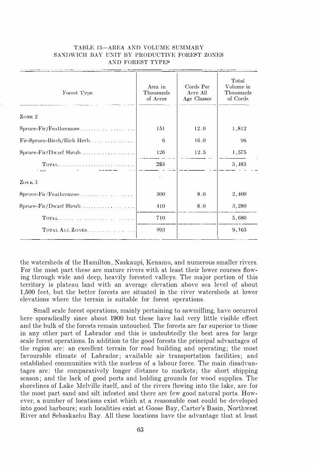
TABLE 1 5--ARE A AND VOLUME SUMMARY
SA:\DW ICH BAY UXIT BY PRODUCTIVE FOREST ZONES
AXD FOREST TYPES
ZONE 2
Spruce-Fir /Fea thcrmoRs .
Fir-Sprucc-Birch/Rieh Herb . .
Spruce-Fir/Dwarf 8hmh .
TOTA L . . .
8pnlce-Fir/Feathcrmos:; .
Spruce-Fir/Dwarf Shrub .
TOTA L .
TOTAL A L L ZONEf> . . . . . I
Area in Thousands
of Acres
1 5 1
6
1 26
�)oo
410
Cords Per Acre All
Age Classes
1 2 . 0
1 6 . 0
1 2 . 5
8 . 0
8 . 0
Total Volume in Thousands
of Cords
1 , 8 1 2
1 , 575
3 , 183
2 , 400
:3 , 280 ------ ------------ - - - _ . _- _ ..
7 1 0 5 , 680
-------------------------�------�----- --
the watersheds of the Hamilton , Naskaupi, Kenamu, and numerous smaller rivers. For the most part these are mature rivers with at least their lower courses flowing through wide and deep, heavily forested valleys. The maj or portion of this territory is plateau land with an average elevation above sea level of about 1 ,500 feet, but the better forests are situated in the river watersheds at lower elevations where the terrain is suitable for forest operations.
Small scale forest operations, mainly pertaining to sawmilling, have occurred here sporadically since about 1900 but these have had very little visible effect and the bulk of the forests remain untouched. The forests are far superior to those in any other part of Labrador and this is undoubtedly the best area for large scale forest operations. In addition to the good forests the principal advantages of the region are : an excellent terrain for road building and operating ; the most favourable climate of Labrador ; available air transportation facilities ; and established communities with the nucleus of a labour force. The main disadvantages are : the comparatively longer distance to markets ; the short shipping season ; and the lack of good ports and holding grounds for wood supplies. The shorelines of Lake Melville itself, and of the rivers flowing into the lake, are for the most part sand and silt infested and there are few good natural ports. However, a number of locations exist which at a reasonable cost could be developed into good harbours ; such localities exist at Goose Bay, Carter's B asin , Northwest River and Sebaskachu Bay. All these locations have the advantage that at least
63

TABLE 1 6-AREA CLASSIFICATION BY FOREST ZOXES
LAKE MELVILLE U N IT
( Area in Thousands of Acres)
Forest Zone Land Area vVater Area Tatal Area
--�--------------------.----- ------- ------- -------
Excellent . . . . . . ( Zone 1 ) 4:36 1 10 546
Good . ( Zone 2 ) 1 , 753 44 1 , 797
Fair to Marginal . . . (Zone 3 ) :3 , 65:3 227 3 , 880
Submarginal to Scrub . . . . . . ( Zone 4) 1 , 708 1 4 1 1 , 849
Tundm . ( Zone j ) 554 I 25 579
----_._--
-------
TOTA L . 8 , 1 04 547 8 , 65 1
twelve million cord:::; o f good timber, with at least half a s much o f poorer quality, exist within a radius of fifty miles. An annual cut of over 300,000 cords could be sustained without going outside this radius.
The area classification (Table 16) does not show any burned land. The last maj or fire occurred here about 1870 and although there has been a number of smaller burns since that date their exact boundaries and areas are undeterminable.
The area and volume summary for this unit (Table 1 7 ) shows a total of slightly over twenty-three million cords. Again it must be emphasized that the amount is for the commercial forest types of the merchantable zones ; the actual amount on this unit that could he han'ested is probably in the vicinity of forty mi Ilion corcls.
The western end of Lake .:\Iel\'ille in many respects is an ideal site for the location of a large wood using industry and the industrial development of this area is long overdue. Hydro-electric power can he supplied by the construction of a 200 mile line from the present development at Grand Falls or it can be developed from potential sources much nearer. High grade pUlpwood can be delinred to a mill site at prices considerably l ess tlmn that paid by most Canadian mills.
The one great drawback is the short shipping season , an annual average of five and one half months, and the necessity for stockpiling six months of the year. The additional stockpiling costs could probably offset the cheaper wood costs with the end result that the industry would be competitiYe. Howe\,er, such an industry ,yould be ideally positioned to take advantage of and to profit by any future deyelopments and hreakthroughs in transportation methods.
I\.a lpokok Bay The Kaipokok Bay Ullit it) the most northerly and also the smallest of the
foul' operational units. The seaward front extends onr a distance of approximately seventy-fiYC miles and in eludes the bays of Kaipokok, Canairiktok and
64

TABLE 1 7-AREA AND VOLUME SUMMARY
LAKE MELVILLE UJ'\ IT BY PRODUCTIVE FOREST ZOl\ES
AND FOREST TYPES
Forest Type
ZOl\;E 1
Spruce-Fir/Fcathermoss _
Fir-Sprllce-Birch/Rieh lIerb _
Spruce-Fir/Dwarf Shrub _
TOTAL .
ZONE 2
Spruce-Fir/Feathermoss _ .
Fir-Spruce-Birch/Rich Herb . .
Spruce-Fir/Dwarf Shrub .
TOTAL . . . . .
ZONE 3
Sprucc-Fir/Feathcrilloss .
Spruce-Fir/Dwarf Shrub . .
TOTAL . . . .
Area in Thousands
of Acres
Cords Per Acre All
Age Classes
Total Volume in Thousands
of Cords ---- 1 ------- -�----- ----�----
1 26 1 7 . 0 2 , 142
28 . 5 G27
81 1 8 . 0 1 . 458 1 ------ --- - -----.- -- ---��.-
229 4 , 227
4 1 7 1 2 . 0 .� , 004
1 8 Hi . 0 288
:347 1 2 . 5
782 !) , 629
. . - - . . . . . . I 522 8 . 0 4 , j iG G28 8 . 0 5 . 024
1 , 1 50 9 , 200
1--
-;·�GI--I-- ----- ---;;�56---
------------------
Uj atok. These are long, narrow, fiordlike bays each extending twenty to thirty miles inland from the outer coastline and each having a maj or river flowing in at its head. The watersheds of these large rivers contain the bulk of the commercial forest. The entire unit covers an area of 4 ,160 square miles and except for the river valleys has a general elevation above sea leycI of 1 ,900 feet. The terrain is generally rugged.
A small company obtained a lease for a port.ion of the watershed of the Kaipokok River in 1939 and operated their limits in 1947. This company encountered difficulties ,yhich were not attributable to natural causes and ceased operations after cutting about 5 ,000 cords of pit pro]1s. This IYC1S the only commercial operation ever undertaken ,yithin the area .
65

TABLE 1 8- AR E A CLASSIFICATION BY FOBERT ZONES
KAIPOKOK BAY UNIT
(Area in Thousands of Acres)
Forest Zone Land Area \-Vnter Area
---------- ----
Good Forpst _ (Zone 2 ) 41)0 !J5
Fail' to :'I Iarginal Forest _ . (Zone 3 ) !l(i8 ll6
Ru!Jnmrginal to RCl'll1l Fo],(" t _ ( Zone -t) 28
Tllndra . . .
TO'1' .. \L _
_ _ _ . _ (Zone 5 ) 1 _____
�84 _
_
_ _ _ . _ _ . . _ \ 2 , 40!J 25 1
----- -----
TABLE 1 !J-AIWA A N D VOLU M E � U j\l:'11ARY
KAIPOKOK BAY U N IT BY PRODUCTIVE FOREST ZONES
A N D FOREST TYPES
Area in Thousand,
of Acres
Cords Per Acre All
Age Cbss('s
Total Area
585
1 , 064
4115
5 [()
2 , 660
Total Volume in Thousands
of Cords ---------------------_·_---------- 1------.. _---- 1----------.. 1 --------
Spruce-Fir/Fe;) t IH'l'lllo:-;:-; _ 1 17 1 2 . 0 1 , 10 1
Fir-Spl'llc(�-Bir('h /Hich I IeI'll . 5 Hi . O 80
8pl'IH'e-Fir/Dwarf Shrub . HI 12 . 5 1 , 21 2
TOTAL . 2 1!J 2 , ()!J6 - '"- _ .... - - 1----- - --------- --
j ')') 8 . 0 !lU7
Spl'IJ('('-Fir/Dwari' 8hmh . . J (j(j 8 . 0 ---
TOTAL _ . 288 2 , 2!J5 i--·------------ --- - .. ------ ------- 1--- --------..
TOT .. I L ALL ZO :\E>-' . 507 -t , nll l
66

The principal advantages of the unit are its good ports and drivable rivers and the concentrated nature of the forests. The disadvantages are : the short shipping season and the long distance to American markets ; the isolated position of the unit ; the lack of social amenities ; and the complete absence of an available labour force.
The forests arc generally inferior to those of other operational units and contain a higher percentage of non-productive land. The area classification (Table 18 ) shows that about b\'enty per cent of the total area is classed as tundra. No recent extensive burned-owl' areas ,yere located within this area.
The area and volume summary (Table 19 ) shows approximately five million cords on the productiYC types of the commercial forest zones with the bulk of this volume being concentrated in the slow-growing Zone 3 forest. In view of the slow-growing nature of most of the forests it seems unlikely that this unit could sustain a large-scale forest industry.
De\'(�lopment of the Kaipokok Bay unit, because of the short shipping season and the long distance to American markets, would appear to depend largely upon the cultivation of European outlets for rough wood.
A forest industry, based upon the exportation of up to 50,000 cords of rough wood annually, is entirely feasible for this unit.
67

SUMMARY
Little factual information is available concerning the forests of Labrador. These forests probably represent the greatest unexploited portion of the boreal forests of the world and will undoubtedly increafie in importance in the future. Before any large-scale development takes place it is essential to increase the present scanty knowledge concerning them, particularly in the fields of ecology, growth and yield, in order to provide a basis for their rational development.
The present study has attempted to give a general description, both qualitative and quantitative, of these forests on the basis of forest stands and individual tree species. A brief outline of the history and problems of the territory is also presented. Field work was initiated in 1 956 and continued annually until 1960 during which time it was extended into all the principal geographic sections. Sampling units were one-tenth acre plots which were normally established in groups of ten under homogeneous forest conditions. A total of 713 plots were so taken with the greatest concentration being in the better and more accessible forested areas.
The territory is situated at the eastern extremity of the Labrador-Ungava Peninsula approximately between latitude 52 ° and 60 ° 30' north and between longitude 560 and 67° west ; it is roughly triangular in shape and covers an area of 1 1 1 ,750 square miles. Topography is that of a plateau with a general slope toward the east but with high coastal mountain ranges occurring in the north and a generally narrow low coastal fringe to the south-east. Plateau elevation varies from 1 ,000 to 2,500 feet above sea level . Rocks are granite-gneisses with extensive areas of anorthosite-gabbro extrusives. These are generally covered with rather thin glacial debris whose texture varies from coarse stoney sands to sandy loams. Extensive areas of alluvial materials are found along the lower courses of mature rivers. The soils are podzols. Climate is cool with considerable variation occurring from south to north, coastal to inland, and lowland to upland. Annual precipitation at recording stations varies from 29 to 40 inches.
The process of arranging the forest of this large and diversified area into categories of similar or comparable productivity was accomplished by stratifying into maj or units, called zones, and into a system of forest types within the different zones. The division into forest zones was based upon climatic differences using a mathematical concept of latitude, elevation and distance from the coast ; this was correlated with the occurrence and behaviour of individual tree species.
Five zones, four of which are forested, were recognized. Within the most productive one the principal forest types, five in number, were identified and described ecologically. The occurrence of these types was traced throughout the other zones and vegetative differences noted. Forest types were arranged into three site classes and a site index was constructed for the most productive zone.
68

Growth and yield of even-aged forest is shown by site classes and forest types for this zone and is approximately correlated to that of other zones . Average merchantable volumes per acre for all-aged virgin forest has been compiled for the individual forest types within all zones. Area estimates of the different categories of forest have been determined from aerial photographs on a percentage basis .
Finally the total merchantable volumes, of available wood on certain proposed operational units, have been determined approximately and the advantages and disadvantages of these proposed units are discussed.
The presented data will be useful to industry as background information but are too extensive to serve as a basis for detailed management.
69

SOMMAIRE
On ne possede que peu de renseignements factuels au suj et des forets du Labrador. Ces forets constituent probablement la plus grande reserve de forets boreales au monde qui soit inexploitee, et il ne fait pas de doute qu'elles acquerront de plus en plus d 'importance dans I 'avenir. Avant d'entreprendre d'amenager ces ressources sur une grande echelle, il faudrait completer les maigres donnees qu'on possede a leur sujet, surtout en ce qui concerne leur ec.ologie, leur rythme de croissance et leurs possibilites de rapport, afin de les exploiter de fagon intelligente.
Le present ouvrage donne une description de ces forets, tant au point de vue qualitatif qu'au point de vue quantitatif, d 'apres les peuplements et les essences qui les composent. Vne breve esquisse des antecedents et des difficultes du territoire en question y figurent aussi. Les travaux d'etude sur place ont debute en 1956 et ont ete repris chaque annee jusqu'en 1960, alors qu'ils ont pris de I 'extension au point de comprendre toutes les regions geographiques du territoire. Les places-echantillons d'un dixieme d'acre ont ete Ie plus souvent etablies par groupe de dix dans des conditions forestieres homogenes. Un total de 713 places ont ainsi ete delimitees, la plupart se trouvant dans les regions forestieres les meilleures et aussi les plus accessibles.
La region etudiee se trouve a I 'extremite est de la peninsule qui comprend Ie Labrador et l'Ungava, et qui est situee a peu pres entre 52 ° et 60° 30' de latitude nord et entre 56° et 67° de longitude ouest ; elle est a peu pres de forme triangulaire et elle a une superficie de 1 1 1 ,750 milles carres. Le relief comprend un plateau generalement incline du cote est mais comprenant des massifs montagneux dans Ie nord , ainsi qu'une bande de terre relativement etroite et basse Ie long de la cote sud-est. L'altitude du plateau varie de 1 ,000 a 2 ,500 pieds au-dessus du niveau de la mer. Les l10ches sont de formation gneissique et granitique, comprenant d'immenses extrusions d'anorthosite et de gabbro. Ces dernieres sont en general recouvertes assez legerement de debris glaciaires qui varient du sable grossier et pierreux aux limons sableux. De grandes superficies de terres alluviales se trouvent Ie long du cours inferieur de rivieres evoluees. Les sols sont du genre podzolique. Le climat est frais, variant sensiblement du sud au nord, de la cOte a I'interieur des terres et des terres basses aux terres hautes. Les stations mCteorologiques enregistrent des precipitations annuelles variant de 29 a 40 pouces.
Le travail de classement des forets de ceUe vaste region d'aspect varie en categories selon leur productivite et leur similitude a ete accompli par stratification de la region en secteurs principaux appeles zones et, de I ' interieur de ces zones, en types forestiers. La repartition en zones forestieres se fonde sur les differences climatiques selon un c,oncept mathematique de la latitude, de I 'altitude et de la distance de la cote ; on a ensuite Ctabli la com§lation entre ces donnees, d'une part, et la frequence et Ie comportement de chaque essence forestiere, d'autre part.
70

On a delimite cinq zones, dont quatre sont des zones forestieres. Dans la zone la plus productiYe, on a identifie les cinq principaux types forestiers et on en a decrit l 'ecologie. La frcquencc de ces types fore stiers a ete determinee dans chacune des aut res zones et on a pris note des differences de yegetation. Les types forestiers ant ete classes en trois categories et on a pris pour indice Ie type forestier de In zone ]a plus produc tiyc. L 'allure de croissance et Ie rendement d'une foret equienne sont donnes pour chaque classe de fertilite et chaque type forestier de ccUe zone, et l 'uuteur etahlit sommai rement la correlation entre cette foret et celles des autres zones. Les volumes llloyens de bois marchand sur pied par acre de foret vierge comprenant dcs pcuplements de tous ages ont ete calcules, pour chacun des types forestiers de toutcs les zones. La superficie estimative des differentes categories de forHs a ete calculee d'apres des photographies aeriennes, en pour-cents.
Enfin, Ie yolume total de bois marchand qui se trouYe dans certaines regions d'exploitation proposees, a ete determine approximativement ; les avant ages et inconvenients de chacune de ces regions proposees font l 'obj et de commentaires.
Les donnees que renferme l 'ouvrage f'eront sans doute tres utiles aux milieux industriels forestiers, mai8 it titre de renseignements seulement, leur portee etant trop gencrale pour qu 'eIIes ]JUissent seryir it un amenagement forestier tres precis.
7 1

REFERENCES
ANON. 1948. Form-Class VoluIlle Tables (Secon(\ Edition) . Canada, Dept. Mines and Resources.
Dominion Forest Sen' ice, Ottawa.
BLAKE, W. 1953. Vegetation and Physiography of the Goose Bay Area, Labrador. McGill
Uni\·ersity. Unpublished thesis.
COOK, H . C. 1929. Studies of the Physiography of the Canadian Shield. 1. Nature Valleys of
the Labrador Peninsula. Roy. Sec . Canada Transact, Ser. 3, Vol . 23, Sect. 4 , P. 9 1 .
Ottawa.
FOHBES, A. 1938. Xorthernlllost Labrador, mapped from the air. Amer. Geographical Sec.
Spec. Pub. No. 22.
GOSLING, \V . G. 1901 . Labrado r : Its Discovery, Exploration and Development. London.
GRIFFITH , A . L. and J . PIlASAD. 1949. The Sih'iculture Research Code. Vol. 3. The Tree and
Crop Measurement Manual . Geodetic Br., Survey of India, Dehra Dun.
HALLIDAY, W. E. D . 1937. A Forest Classification for Canada. Dom. For. Servo Bull . 89.
Ottawa.
HAilE, F. K. 1950. Climate and Zonal Divisions of the Boreal Forest Formation in Eastern
Canada. Geogr. Rev . 40 ( 4 ) : 615-635.
H.HTRWITZ, B. and J. M. AUSTIN. 1944. Climatology. 4 1 0 pp. McGraw-Hill Book Company, Inc. New York and London.
HUSTICH , 1. 1949. On the Forest Geography of the Labrador Peninsula. A Preliminary
Synthesis. Acta Gcographica 10, No. 2 . Helsinki.
---- 1954. On Forest and Tree Growth in the Knob Lake Area, Quebec-Labrador Penin
sula. Ada Geogr. 13 ( 1 ) : 3-60.
KINDLE, E. M . 1924. Geography and Geology of Lake Melville District, Labrador Peninsula.
Canada, Dept. Mines and Geological SurYeY, Memor. 14l .
LINTK-HT, A. 1955. Forest Site Classification of the Xortheastern Coniferous Section, Boreal Forest Region, Quebpc. Canada, Dept. Northern Affairs and National Resources, For. Br.
Bull. 118.
Low, A. P . 1896. A Report on Explorations in the Labrador Peninsula, along the East Main,
Koksoak, Hamilton, M anicuagan and Portions of Other Rivers in 1892-95. Geological Survey Annual Report, VIII, N .S.L., Ottawa.
McLI,AN , J. 1849. Notes of a Twenty-fi\'e Years' Service in the Hudson's Bay Territory. London.
Report of the Newfoundland Royal Commission on Forestry. 1955. Queen's Printer, New
foundland.
Row,;, J . S . 1959. Forest Regions of Canada. Canada, Dept. Northern Affairs and National
Resources. For. Br. Bull. 123.
SPlJRH, S. H . 1952. Forestry Inventory. 476 pp. The Ronald Press Company, New York.
TAN NEil, V. 1944. Outl ines of the Geography, Life ancl Customs of Newfoundland-Labrador.
,\cta Geographica 8, No. 1 , Helsinki.
TowNsm;Nll, C . W. 191 1 . Captain Cartwright and His Labrador Journal. London.
WILTON , \\' . C. 1959. Forest Types of the Grand Lake and Northwestern Lake Melville Areas of Labrador. Canada, Dept. Northern Affairs and National Resources. For. Br. Tech.
Note 83.
72


![Phillips, Kim (NRCan/RNCan) · From: Phillips, Kim (NRCan/RNCan) [mailto:kim.phillips@canada.ca] Sent: Thursday, October 05, 2017 10:26 AM To: Phillips, Kim (NRCan/RNCan) Subject:](https://static.fdocuments.net/doc/165x107/5ad08ac87f8b9a6c6c8e6906/phillips-kim-nrcanrncan-phillips-kim-nrcanrncan-mailtokimphillips-.jpg)


