Hydrology research in the upper Indus basin, … Hydrology research in the upper Indus basin Climate...
14
Hydrology ofMountainous Areas (Proceedings of the Strbské Pleso Workshop, Czechoslovakia, June 1988). IAHS Publ. no. 190,1990. Hydrology research in the upper Indus basin, Karakoram Himalaya, Pakistan G.J. YOUNG and K.HEWITT Cold Regions Research Centre, Wilfrid Laurier University, Waterloo, Ontario, N2L 3C5, Canada ABSTRACT This paper examines the hydrological, meteoro- logical and glaciological characteristics of the Upper Indus Basin, Pakistan as they influence water supply. In the past, apart from some long-term discharge records for the Indus and some of its major tributaries, hydrological measurements were very scarce. Meteorological measurements were almost wholly confined to valley bottom locations thus missing the hydrologically most active zones above about 30O0 m elevation. Glaciological investigations have largely been confined to work done on an ad hoc ba- sis and in a limited number of basins by international expeditions. A joint Pakistan-Canada research effort during the last three years represents a concerted effort to remedy these deficiencies. The aim of this cooperative project is to build up a systematic and long term data base to understand, in particular, the relative contributions to streamflow of rainfall, snowmelt and glacier ice melt. This understanding should allow more rational planning and more effective operational streamflow forecasting. Models being developed or applied to the basin at the present time are described. THE GENE-RAL IMPORTANCE OF WATER IN THE INDUS BASIN While some of the headwaters of the Indus River lie within China and India, most of the Indus Basin lies within Pakistan. The water supply provided by the river is critical to most aspects of the country's economy. Large areas of the Punjab are irrigated by Indus waters. A major part of the country's hydro power is derived from the ïriver, while groundwater supplies are argumented by streamflow. They supply much of the country's electri- city ,. major irrigation works and regulate flows in order to alleviate flood hazards. Most of Pakistan's population lives in the desert or semi—desert Indus plains. The bulk of the Indus waters are derived from the river's high mountain headwaters. The main stem of the Indus above the Tarbela dam pro- bably receives as much as 80% of its flow from snow and ice melt as do other western tributaries, the Kabul and Swat. Most of the flow of the left bank tributaries, traversing the Punjab, is derived from snow melt during 139
Transcript of Hydrology research in the upper Indus basin, … Hydrology research in the upper Indus basin Climate...
Hydrology ofMountainous Areas (Proceedings of the Strbské Pleso Workshop, Czechoslovakia, June 1988). IAHS Publ. no. 190,1990.
Hydrology research in the upper Indus basin, Karakoram Himalaya, Pakistan
G.J. YOUNG and K.HEWITT Cold Regions Research Centre, Wilfrid Laurier University, Waterloo, Ontario, N2L 3C5, Canada
ABSTRACT This paper examines the hydrological, meteorological and glaciological characteristics of the Upper Indus Basin, Pakistan as they influence water supply. In the past, apart from some long-term discharge records for the Indus and some of its major tributaries, hydrological measurements were very scarce. Meteorological measurements were almost wholly confined to valley bottom locations thus missing the hydrologically most active zones above about 30O0 m elevation. Glaciological investigations have largely been confined to work done on an ad hoc basis and in a limited number of basins by international expeditions.
A joint Pakistan-Canada research effort during the last three years represents a concerted effort to remedy these deficiencies. The aim of this cooperative project is to build up a systematic and long term data base to understand, in particular, the relative contributions to streamflow of rainfall, snowmelt and glacier ice melt. This understanding should allow more rational planning and more effective operational streamflow forecasting. Models being developed or applied to the basin at the present time are described.
THE GENE-RAL IMPORTANCE OF WATER IN THE INDUS BASIN
While some of the headwaters of the Indus River lie within China and India, most of the Indus Basin lies within Pakistan. The water supply provided by the river is critical to most aspects of the country's economy. Large areas of the Punjab are irrigated by Indus waters. A major part of the country's hydro power is derived from the ïriver, while groundwater supplies are argumented by streamflow. They supply much of the country's electricity ,. major irrigation works and regulate flows in order to alleviate flood hazards.
Most of Pakistan's population lives in the desert or semi—desert Indus plains. The bulk of the Indus waters are derived from the river's high mountain headwaters. The main stem of the Indus above the Tarbela dam probably receives as much as 80% of its flow from snow and ice melt as do other western tributaries, the Kabul and Swat. Most of the flow of the left bank tributaries, traversing the Punjab, is derived from snow melt during
139

G.J. Young &K. Hewitt 140
spring and summer with a major monsoonal rain contribution in late summer.
As a result of the Indus Water Treaty of 1960, India has the right to divert substantial portions of the flow of the Sutlej, Ravi, Beas and Chenab (Michel, 1967). Some of those waters have already been diverted putting increasing demands on the Jhelum, main Indus and western tributaries. A large part of the river engineering projects in Pakistan are replacement works. As a result, Pakistan must rely more and more heavily on water derived from snow and ice melt.
With a growing population but, especially, with development that puts ever increasing demand on water supply, water shortages are of more frequent occurrence. Likewise, flood risks tend to increase. It is extremely important, then, for Pakistan to improve understanding of the processes of snow and ice melt in order that better forecasting procedures may be developed.
THE HYDROLOGY OF THE KARAKORAM
The nature of the terrain
The Upper Indus Basin consist of a series of mountain ranges of extreme ruggedness and exceptionally high elevations. The ranges run approximately west-east in an arc from the Hindu Rush and Pamirs in the west and north to the main Himalayan chain to the south and east. The latter culminates in the Nanga Parbat massif, which forms a barrier to the northward movement of monsoon storms. The Central Karakoram forms the major part and water sources of the Upper Indus. With hundreds of peaks in excess of 6000 m elevation, it consist of a wide belt of mountain ridges and high valleys. On the Greater Karakoram Range there is extensive formation of glaciers. This is in contrast to some of the lesser ranges, and much of the Greater Himalaya chain to the east whose high, but areally not very extensive, massifs are separated by deeply incised antecedent rivers, and do not support glaciers of such extent or concentration as those in the Karakoram.
The glaciers of the Karakoram cover an area of about 16300 km2. About 13000 km2 lie within Pakistan (Mercer, 1975). While there are many thousands of glaciers in this region a few large glaciers account for a disproportionate area - Table 1 shows that some 20% of glacier area is accounted for by the largest 3 glaciers and that the largest 23 glaciers account for about 60% of the glacier area (von Wissman, 1959; Hewitt, 1985). It is the ablation zones of these large glaciers which produce the bulk of glacier ice melt.

141 Hydrology research in the upper Indus basin
Climate of the Karakoram
There are two principal sources of precipitation in the Indus Basin. The dominant source in terms of total amounts of precipitation delivered is probably the monsoon, bringing storm systems from the south. These storms are restricted in time from late July through September. They deliver heavy precipitation to the Main Himalaya and Front Ranges. Mayewski and Jeschke (1979) and Mayewski et al. (1980) have shown that in some years the monsoon is strong enough to break through the Front Ranges and can deliver substantial precipitation to the central Karakoram region. Our weather observations in 1985 and 1986, along with snow accumulation studied by Wake (1987) in the Snow Lake region of the Biafo Glacier drainage, indicate that there were substantial snowfalls in the Central Karakoram derived from summer monsoonal incursions. The second source of precipitation is depression coming from the West. This is the major moisture source during winter months. A secondary summer accumulation season at high elevation in the Karakoram and Hindu Kush usually derives from the same source. These westerly sources provide the dominant nourishment for the glacier systems of the Karakoram.
Table 1 Area and length of major valley glaciers in the Karakoram (after von Wissman, 1959)
Name Area (km2) Length (km) S i a c h e n B a l t o r o B i a f o H i s p a r Rimo Skaiar i * Paniaah Chog-o Lungma Konclus The Ron g Bat \ara Khuïrdopin S a r p o Laggo * Bral_du V i r j e rab K e r o Lungma B i l a f o n d YazçjhiL * Rior iq Barfp-u K2 CDepsang) * Karambar Staeghar *
1182 .5 757 .2 6 2 7 . 5 622 .3 510 .8 427 .9 410 .0 331 .9 311 .2 295 .6 290 .4 2 8 0 . 1 230 .8 2 0 2 . 3 198 .3 150 .4 150 .4 145 .2 140 .0 1 3 6 . 1 135 .4 132 .2 129 .7
75.0 62.2 68.0 53.1 45.1 41.1 44.0 47.0 32.0 27.4 59.6 41.1 33.0 35.1 36.1 20.9 22.5 30.1
33.8 17.7 27.4 29.0
*Glaciers not within the Indus Basin
G.J. Young &K. Hewitt 142
A common characteristic is great spatial variability in precipitation valid for short distances and also regionally. The Karakoram exhibit exceptional spatial and especially altitudinal variability. Two strong regional trends may be discerned. As a result of the monsoonal influence, the Front Ranges towards the south and east b'f the basin receive heavy precipitation. Farther north and west this source of moisture is less important. The westerly depressions give most of their precipitation to the western and northern portions of the region while there are discernable gradients towards the centre and east of the basin reflecting shadowing by the major ranges. The combination of these trends produces extrem-ly high precipitation on the main Karakoram Range, the upper Swat drainage and Nanga Parbat massif. Semi-desert conditions occur in much of the interior valleys, plateaux and ranges of the eastern Upper Indus and Shyok watersheds. Extreme local relief is associated with extreme altitudinal variability in precipitation. The deep and often extensive valley bottoms are characterised by aridity, while the high mountains close by receive heavy precipitation. The bulk of all precipitation occurs in an altitudinal zone roughly between 2500 m and 6000 m elevation. The elevation of maximum precipitation is probably about 5000 m in the western Karakoram, 6000 m in the eastern Karakoram.
Surface air temperatures exhibit extreme spatial variability dependent primarily on elevation, but with strong seasonal and diurnal cycles (Fig.l). Solar radiation, the prime source of energy for the melting of snow and ice over most of the basin, exhibits great spatial variability as a function of elevation, surface slope, aspect and changeable weather conditions. Thus, north facing and south facing slopes commonly have quite different radiation regimes, producing marked difference in local hydrology.
The high temperatures and very dry atmosphere normally prevailing throughout most of the summer within the valley system of the Upper Indus Basin promote high evaporation rates. In many of the low-lying areas within the Karakoram evaporation is so high that the only surface runoff occurs during rare, torrential thunder storms. As a result of the combination of low precipitation coupled with intense evaporation in these valley bottom situations, water yield from those areas is negligible, their annual water balance, negative.
Elements of a hydrologie model
In describing the hydrologie model for any mountain range it is convenient to think of rainfall, snowmelt and icemelt as the three major components water yield. Each of them is space and time dependent. All are depen-

143 Hydrology research in the upper Indus basin
8000
7000-
6000-
5000
4000
3000
2000-
1000-
Low Glacier Cover Mode ra te Precipitation
HINDU KUSH
High Glacier Cover Heavy Precipitation
Above 5000m
Many major glaciers with termini at 2000 - 3000m
in west and 4 0 0 0 - 5 0 0 0 m in east
KARAKORAM
GILGIT R. HUNZA R.
Low Precipitat ion
Elevation and Timing ot
Freeze-Thaw Cycles
elevation (m)
6000
•5000
•4000
3000
•2000
•1000
continuous below
freezing temps
frequent f reeze thaw
cyc les
continuous above
freezing temps
Afghanis tan! Nor thern Pak is tan
Fig.l West-east transect at 36°N latitude
dent on elevation, season and location within the region. In the Karakoram freezing conditions prevail for part of the winter at all elevations (Fig.l), so that nearly all precipitation falls as snow. Thus most of the precipitation derived from westerly depression is snowfall. In July and August temperatures above freezing prevail up to 5000 m. Hence most of the monsoon precipitation falls as rain, especially in the Front Ranges. While rainfall makes its way immediately into the river system (with lags dependent on surface and subsurface conditions), snowfall remains in place (apart from the local redistribution by winds, avalanches and glacier flow) until the spring and summer. The snowmelt yield from lower elevation is modest and rapid, occurring in early spring. Yield from progressively higher elevations is slower, compressed into fewer months of the year, but is greater in total supply because of the much deeper snowpacks. Glaciers represent long term storage reservoirs of water.
There are very significant transfers of snow and ice within the hydrological system prior to melt. Snow is redistributed after falling by two major processes. Wind action redistributes snow locally (usually within a few hundreds of metres of where it originally fell). Deflation in some areas accompanied by drifting and great thickening in adjacent areas occurring during winter has important implications for the details of snow-melt processes taking place in the spring and summer seasons. Avalanching of both snow and ice is a major process of redistribution in the Karakoram. It greatly affects the nourishment processes of most glaciers in the region and has major implications for melt hydrology in that vast quantities of snow and ice are transported to much lower elevations very quickly (primarily during spring
G. I Young & K. Hewitt 144
time but continuing at high elevation throughout the summer) where they melt out relatively slowly but consistently. Huge quantities of ice are steadily transported downslope as a result of glacier movement from the accumulation areas where snowfall exceeds melt to the ablation areas where there are net annual losses of ice. Compared to avalanching or meltwater flow, glacier movement is slow - it may take hundreds of years for individual particles of ice to move from place of original deposition to the place of melt - but it is a constant process. Ice is moved from as high as 6000 m - 8000 m elevation down to 3000 m. Karakoram glaciers, unlike most continental glaciers, are relatively vigorous. Our measurements indicate flow rates in the middle ablation areas in excess of 150 m per annum.
Results of our studies on the Biafo Glacier (surface area 627 km2) indicate that some 0.5 km2 per annum move from the accumulation area to the ablation area. This volume of water (which equals a mean annual yield from the ablation area of 3000 mm) represents total annual meltwater volume from ice from the ablation area: this does not include seasonal snowmelt from both the ablation and accumulation areas of the glacier nor does it include ice melt (or ice accretion) as a result of the glacier being out of equilibrium with climate.
In years of heavy winter snowfall and/or in cool summers, the glaciers grow in size, storing water from one year to the next. The converse holds in years of light snowfall and/or warm summers. Glaciers therefore perform the important function of regulating streamflow. It is probable that some 70-80% of the flow from major Indus tributaries in the Hindu Kush, Karakoram and Nanga Parbat ranges derive from glacier basins.
Taking the discharge records from the principal gauging stations in the Upper Indus Basin as a primary source of information, Table 2 shows mean annual basin yields for the major sub-basins in the region. The same information is the basis for the map (Fig.2). It is apparent from these data that yield varies greatly between basins, from lows of near zero for parts of the region to highs of greater than 1400 mm per annum for the upper Swat basin and greater than 2 400 mm per annum for the south west slopes of the Nanga Parbat massif. Within sub-basins there is also very great variability; as noted above, mean annual yields from glacier ablation areas (from ice melt alone without melt of seasonal snow cover or summer rainfall) can be greater than 2500 mm per annum.
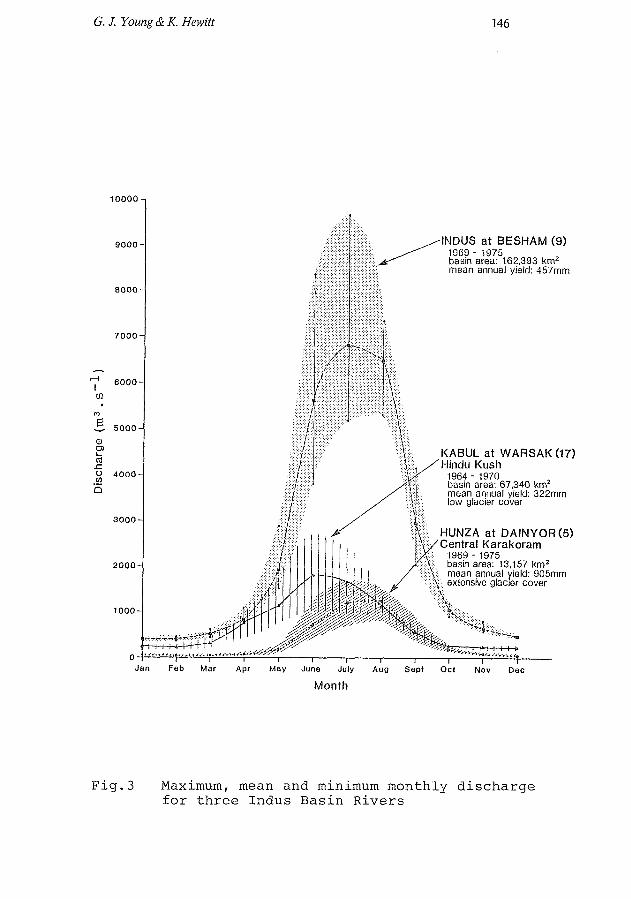
Temporal variability in discharge is another outstanding feature of the Upper Indus Basin. Fig.3 illustrates monthly discharges for the Indus at Besham, the Kabul at Warsak (large snowmelt contribution) and the Hunza at Dainyor (highy glacier covered). Summer snowmelt in

145 Hydrology research in the upper Indus basin
Fig.2 Upper Indus Basin - annual water yield
combination with glacier ice melt produce the very high peaks of mid and late summer. In the Front Ranges, however, spring and summer snowmelt is later augmented by monsoon rains to produce even higher instantaneous discharges.
Glacier outburst floods occur throughout the Karakoram and several classic events have taken place this century; documentation of these has been given by Hewitt (1982). The truly catastrophic floods on the Shyok of 1926 and 1929, Gunn et al (1930), Mason (1929) have not been equalled in recent years, but there have been some relatively small floods which have still proven disastrous for villages in the region. During the 1929 flood on the Shyok/Indus system river stage at Attock, some 1200 km from the glacier dam, rose 8.lira.Sediment yields during these exceptional flood events can be several orders of magnitude greater than normal.
The data base
The major discharge measuring stations in the Upper Indus Basin are listed in Table 2. Very few of these records are longer than 30 years, most have periods of missing data and several have only staff gauges which are often only read during daytime and in the periods of high flow. Despite these inadequacies in data quality, the discharge records present the most reliable and comprehensive data source available to the hydrologist. The discharge records are the summation of all hydrological processes within the basin; the watershed modellers have the task
G.J. Young & K. Hewitt 146
INDUS at BESHAM (9) 1969 - 1975 basin area: 162,393 km2
mean annual yield: 457mm
KABUL at WARSAK(17) Hindu Kush
1964 - 1970 basin area: 67,340 km mean annual yield: 322mm 'ow glacier cover
HUNZA at DAINYOR(5) Central Karakoram
1969 - 1975 basin area: 13,157 km2
mean annual yield: 905mm :': extensive glacier cover
Mar Apr May June July Aug Sept Oct Nov
Month
Fig.3 Maximum, mean and minimum monthly discharge for three Indus Basin Rivers

147 Hydrology research in the upper Indus basin
of explaining the records in terms of meteorology and terrain characteristics.
Meteorological data are very sparse indeed within the mountainous sections of the Upper Indus Basin. The few existing stations usually have sporadic records of questionable quality; all major stations are located in valley bottoms, far lower than the zones of maximum precipitation, and the temperature records provided are difficult to extrapolate to high elevation. It is because of this lack of good meteorological data that the Snow and Ice Hydrology Project has put a high premium on establishing at least a small number of high level stations within the Upper Indus Basin.
Most of the glaciological data collected to date has been collected within very restricted local areas and over short time periods. Major expeditions devoted primarily- to glaciology have been few and far between; the Chinese expedition to the Batura and neighbouring glaciers in the 1970's was probably the most comprehensive such expedition until the Snow and Ice Hydrology Project. Other scientific and mountaineering expeditions such as the 19 34 German Himalayan Expedition to Nanga Parbat. (Finsterwalder et al. 1935) , the Italian expeditions of 1953-55, (Desio et al. 1951), and the 1980 International Karakoram Project, (Miller, 1984), have provided very useful information. However, these efforts were not coordinated with one another and much of the information collected is thus difficult to use.
For general topographic information there are several small scale maps available. These are supplemented by a small number of detailed topographic maps of restricted areas such as that produced from the 1939 Shipton survey of the Biafo-Hispar glacier area (Mott, 1950). Maps detailing past or present glacier extent are very scarce. Aerial photography is almost impossible to obtain. Several studies are now using satellite imagery - the potential for such use in this remote area is clearly great -however the difficulties of interpretation of imagery have not yet been satisfactorily resolved.
THE SNOW AND ICE HYDROLOGY PROJECT
In 1985 a three year project was started in the Karakoram, jointly funded by Pakistan and Canada, to develop expertize relevant to understanding snow and ice melt processes. The lead agency within Pakistan is the Water and Power Development Authority (WAPDA) and the main sponsor within Canada is the International Development Research Centre (IDRC). The project is coordinated through Wilfrid Laurier University with cooperation from several other universities in Canada, UK and USA. The aim of the project is to set up within WAPDA a unit well versed in both field and office techniques which will have the

G. J. Y
oung & K
. Hew
itt 148
03 O
•H
-P
03
•H
U CO •P
U
rd M
rd xi v c •H
03 rd
CM
CO H X
I
m
EH
cd tn m
S id
o
C
rd
CO
rd
U
(d rH
1
3 *
'en
do
c ° e
cd ,
3 &
m
a
o n
fi H
g
rd 4-1
*—
C
O
03
id 4-i
g
<G X
i 4-1
a
* O
H
rd
«
CO
g
U
X
g
rd S
3
O
m
IX
CM
1X>
CM
IX
\D
in (T
i en
00
r~
o
o
o
r-o
Cn
IX
m
•if
r»
00
in
in
00
00
oo
00
m
m
en
«* rH
rH
co
CM
r-o
iH
in
oo
<x
ro
'tf' 0
0
CM
r^ ro
•^
IX
00
Cn
0
0
rH K
O
CM
C
M
Cn
<X
<
tf 0
0
rH C
O
00
00
CM
in
00
00
CM
in
rH
rH
rH
O
00
•*
00
r~
rH
rH
IX
rH
00
in rH
1X
1 0
0 rH
r~ 0
0 CM
t--o CM
^f
"* ^
f cn in in
"* CM
r~
CM
1X5
CO
VD
in r~ 0
0
oo
o^
ftHin
om
cP
ir~-in
oo
r^ro
'*in
r^c
Mix
>c
Mro
NM
nO
OC
O<
J,H
lfH
fl'S
"ïin
HH
'*N
rH
ÛO
o
ocM
r^oo
cno
ocn
^t,^r<
'3,C
Mm
co<
*co
rHo
or-cn
<*
«ï
MD
in
oN
ui
ii
nk
DO
Hi
n^
in
co
ro
in
^œ
o
oc
no
oo
r^r-o
orH
oo
or-o
^F
cn
oo
rHO
CN
r-^ [^
oo
xM
^h
-co
cric
oo
oio
ifloo
[^v
o,*
i^l^
l^i^
ixin
Ln
r^c
nc
Mc
nix
inc
nc
o^
'tf'tfinix
ixo
oo
in
oo
vD
wc
oo
HW
NH
om
oi
nr
oc
ni
nc
oœ
h ^
OO
CM
CM
CN
^r
HO
OO
OO
rH
in
in
oO
^r
^O
OO
Or
Hr
H
rH
rH
rH
rH
rH
rH
rH
rH
rH
rH
CM
rH
rH
rH
rH
rH
rH
rH
rH
rH
oo
ixc
nr^
cM
r^c
no
oo
vx
'tfino
oo
.Hc
oc
no
"3
,o CM
O
in in
oo •*
HI
T)
CM 0
0
CM C
n KO
0
0 IX
*3<
CM
KO
in
OO
O
0
0 rH
oo
r-
r- •
oo
i-t TJ<
C
Of
flO
rH
iH
CM
in CM
CM
0
0
in C
M
KO oo
en oo r-
o
o oo oo
CM r~
K
O
<tf rH
rH
cn
r~
-c
oo
cn
rH
<3
lr-
co
in
cn
cM
r-
~c
Mo
oi
nr
'-c
n'<
*i
x
CTl C
Tl in
00
rH ^X
>
*
00 C
O •si 1
en
*tf 00
00 "tf
r- m
C
M o
o
•<*
rH
CM
m
m
oo
CTl
rH
CM
O
r
H C
M
rH
00
00
en en C
M
IX
rH
•* O
rH in
rH r~- co in
in
rH 0
0 V
D O
O
C
M
CT
l 00
CM
rH
^fo
cn
cM
rHc
no
cn
inc
nr^
oo
•* oo H
<*>*iDmr--Hcn
00 rH 00
^
H CO
00 O CM
KO O
IX 00
IX 00 O rH
00 CM
r- iH
oo co in r- oo
M1
oo en oo •*
vo rH r~-K
O in <* en oo ̂
r rH CM CM
r- o oo
en o CM r- in oo
K
O oo r~-
00
CM 00
f-
KO
CM oo r-
VD
KO en
f-
00
KD
f- 00
CO
1X> CM rH
in •* r~
CM i-o
r̂
m rH «* o
m CM
o en r-
CM iXi
r» CM
00
VX O CM
en o o
CM
IX •^ rH rH f- 00 rH
in "*
oin
inc
nr-c
no
cM
oo
cn
co
t^r-o
co
r-oix
iixio
r-ixic
nm
ino
'*r~
-cn
rHc
nm
cn
oo
r~-'*
'a,c
nr~
-cM
I
Xi
lX
lO
rH
rH
r^
O^
OO
Oi
nO
r^
rH
in
OO
OO
OO
r^
O
OO
CM
CM
IX
OO
CM
^P
^C
MI
X
rH
CM
-s
fO
Or
Hr
-r
Hi
nC
M
fO
HH
(N
H<
* L
D1X
1UD
1
X1
00
>
X>
rH
rH
rH
rH rH
rH
CM
^-
v -—*. ,—̂
rd
-P
U
3
•H
^ tn
g
S£
HH
) tn
u
o
>H
W
•
X o
•H
H
rd U
<
S4
—
03 3
-̂̂
-̂̂
-M -M
-H
-H
-̂*, r-l
»̂, O
X
! >
i rd
C
4J
•H
rd
Q -̂'
rd
tn
tP
N
^^
3
H
rH
xi
co c
H
•H
-H
U
rd
CM
—
03 0
-̂̂
ti rd
-H
-̂̂
c
•H
^-
H
g
rd
^M
.
Ti
a
rd
03 Xi
X!
>i
M
O
Q -̂̂
M
O
rd
m
-̂̂
en
3
03
a) w
_̂* 03 3
u
.-o*.
U
rd ^̂
rd
,-̂
-̂̂
rd
X
*•—
.
rd
U
Cl)
B>
MH
0
£
Cn
H
rd
S
QA
0
rd -P
ai
O
Xi
Xi
-P
Q
*—' *—
3
03 fÇ
S
3
C
T3 4->
'O >d "C
3
o o
m
G
H
03
< a
H
d
H
c
C
rd
M
03 S
O
-P
03
O
CM
-H
10
C
rd
rH
rd
r-̂
M
J*
-P
rd -H
«-W
*
rd
U
rd
03 X
i H
3
rl
Ui
i rd
—
Pu
EH
-<
2
XI
15
—'
a
m
u
•H •—
-̂̂
fi
03
rd
3
•—
—1
3
U
-0
Xi
•H
fi rd
H
m co
en H
« l->
'—
-rd
,-
v
g
rd
rd
H
XI
rd
~"
H
O
«
rd
rH
M ^^
3
-P
-P
M
Xt-H
rd
rd
X
I rd
S
m
M o
co -—
-•P
rd
S
CO
OrH
CN
oo
^in
ixir^
oo
cn
o C
MO
0-
=*
in
iX
ir
--
00
Cn
rH
iH
iH
rH
rH
rH
rH
rH
rH
rH
CM
149 Hydrology research in the upper Indus basin
capabi_Iity of better predicting river flows and of predicting extreme flood events. The initial phase of the project concentrated on developing field expertise. This will continue in the future and the later phases of the project will concentrate more on developing computer models of river flow based on the field measurements. At present approximately equal numbers of Pakistani and Canadian personnel are involved, with WAPDA providing logistical support and Canada providing much of the technical equipment and advice.
Fie Id work in the first three years has been concentrated in two main areas - the Biafo-Hispar glacier area of the central Karakoram and the Nanga Parbat / Khagan Valley area. In both areas basic data are being collected on:
(a) Meteorology - temperature, radiation, precipitation and wind records are being monitored by a combination of automatic digital recording devices set up in small networks to cover elevation ranges within small areas and standard Stevenson screen setups with graphically recording thermohydrographs.
(b) Hydrology - records from the standard stream gauges which have been operated by WAPDA for many years have been supplemented by stream gauges set up close to glacier termini. These additional gauges are installed to run for relatively short periods to investigate the detailed glacier components of runoff.
(c) Glaciology - an inventory of snow and ice resources has been initiated and a monitoring program has been started to determine rates and timing of melt. Special studies on avalanche contributions to melt processes are being undertaken in the Khagan valley while studies on the effects of debris cover on melt rates are under way on the Biafo-Hispar. Glacier movement studies are being undertaken in both areas.
The initial three year phase of the project (1985-87) is now being extended to cover the summer field season of 1988; thereafter an operational phase will probably be entered, supported by the World Meteorological Organisation and the Canadian International Development Agency, involving the use of the physically based real time forecasting models being developed at the University of British Columbia.
Scientific results of significance
The meteorological data collected at high elevations, only available for relatively short periods of time are proving very valuable in establishing lapse rates under a variety of conditions: high level data are as critical in supplementing the low level data already available. Sites for permanent meteorological stations with telemetering capabilities have been chosen and these new

G. J. Young & K. Hewitt 150
stations are scheduled to be installed in the operational phase of the project.
The snow pits and snow cores taken on the upper Biafo Glacier at elevations of 5000 - 6000 m are some of the first and most extensive such measurements taken in the Central Karakoram. They are therefore of prime importance not only in estimating overall quantities of precipitation in this the zone of maximum input, but are also of great importance in establishing the derivation of major precipitation events (ie. whether they are monsoonal and derived from The Arabian Sea or depressional and derived from the west).
Stake networks established in the ablation zones of several major glaciers (significantly the Biafo, Miar and Sumaiyarbar) are helping to establish melt rates from these very important source areas for meltwater. Data from those areas of the ablation zones of glaciers with extensive debris covers are more difficult to interpret but are none the less useful in establishing water yield from these areas.
Measurements of glacier surface velocities in combination with cross-sectional depth profiles established with radio-echo sounding equipment are providing estimates of annual ice fluxes through the cross sections; this information is very useful in estimating total annual quantities of water yield of the lower sections of the glaciers.
A large data base of all available measurements taken at 21 hydrometric and 25 climatological stations in the Upper Indus Basin has been assembled and is available for input to the UBC Watershed Model. The model has now been calibrated and extensively used for the Jhelum River above Mangla Dam. The model will now be applied to the Indus main stem above Tarbela Dam.
Extensive snow surveys, including mapping of major avalanche tracts, calculation of volumes of snow transported down tracts and monitoring of the timing of melt from the tracts have been accomplished within the Khagen Valley in the Front Ranges. These surveys are regarded as critical for helping to define melt rate inputs to the UBC Watershed Model.
Future directions and field program for summers 1988 and 1989
Maintain basic hydrological, meteorological and glaciolo-gical measurements in Khagan Valley and on Barpu/Miar/ Sumaiyarbar Glaciers, Maintenance of these regular field monitoring activities will extend and consolidate the data base already existing for these areas.
An expanded glaciological and hydrological program to extend regional coverage. This part of the program to consist of three parts:
(a) Mapping of former and existing glacier-dammed lake

151 Hydrology research in the upper Indus basin
sites in order to assess potential flood magnitudes should existing lakes suddenly release ar should glaciers advance causing past lakes to reform.
(b) Fixing marker stakes in several glaciers as near to the -equilibrium line as possible and monitoring these stakes for surface movement and measuring glacier depth by radio-echbsounder in order to extent our knowledge of ablation rates in the lower sections of the large glaciers.
Digging snow pits in the accumulation areas of the glaciers to estimate annual snowfalls.
This part of the research program represents a major geographic extension to the current activities of the Snow and Ice Hydrology project; it includes a component of glacier-dammed lake study, hitherto largely ignored.
REFERENCES
Barry, R.J. (1981) Mountain Weather and Climate. Methuen, London: New York
Desio, A., Marussi, A., and Caputo, M. (1961) Glaciolo-gical research of the Italian Karakoram expedition 1953-1955. Snow and Ice Commission,IAHS, Publ.No.54, 224-232
Finsterwalder, R., Raechl, W., and Misch, P. (1935) Scientific work of the German Himalayan Expedition to Nanga Parbat, 1934. Himalayan J., Vol.7, 44-52
Gunn, J.P., Todd, H.J., and Mason, K. (1930) The Shyok flood 1929. Himalayan J., Vol. 2, 35-47
Hewitt, K. (1968) The freeze-thaw environment of the Karakoram Himalaya. Canadian Geographer, Vol.12, No.2, 85-98
Hewitt, K. (1982) Natural dams and outburst floods of the Karakoram Himalaya. In: Hydrological Aspects of Alpine and High Mountain Areas. Glen J.W. ed., IAHS Publ. No.138, pp. 259-269
Hewitt, K. (19 85) Snow and ice hydrology in remote, high mountain areas: the Himalayan sources of the River Indus. Snow and Ice Hydrology Project Working Paper No.l, Wilfrid Laurier University, 29 p.
Lanzhou Institute for Glaciology and Cryopedology, (Aca-demia Sinica). (1979) The Batura Glacier in the Karakoram Mountains and its variations.Scientia Sinica, Vol.22, 958-974
Mason, K. (1929) Indus floods and Shyok glaciers. Himalayan J. Vol.1, 10-29
Mayewski, P.A. and Jeschke, P.A. (1979) Himalayan and Trans-Himalayan glacier fluctuations since AD 1812. J.Arctic and Alpine Research Vol. 11, 267-287
Mayewski, P.A., Pregent, G.P., Jeschke, P.A. and Ahmad, N. (1980) Himalayan and Trans-Himalayan glacier fluctuations and the South Asian monsoon record.
G. J. Young &K. Hewitt 152
J.Arctic and Alpine Research. Vol. 12, No. 2, 171-182 Mercer, J.H. (1975) Glaciers of the Karakoram. In: W.O.
Field Mountain Glaciers of the Northern Hemisphere. Vol.1, CRREL, Hanover New Hampshire, 371-409
Michel, A.A. (1965) The Indus Rivers:study of the effects of partition. Yale University Press, New Haven, Conn., 595 p.
Miller, K. (ed) (1984) The International Karakoram Project. Cambridge University Press, Cambridge, 2 vols.
Mott, P. (1950) Karakoram survey, 1939. A new map. Geog.J., Vol.116, No.1-3, 89-95
Snow and Ice Hydrology Project (1986) Annual report 1985. Wilfrid Laurier University, 237 p.
Snow and Ice Hydrology Project (1987) Annual report 19 86. Wilfid Laurier University
Wake, C.P. (19 87) Spatial and temporal variation of snow accumulation in the Central Karakoram, Northern Pakistan. MA thesis. Dept. of Geography, Wilfrid Laurier University, 121 p.
von Wissman, H. (1959) Die Heutige Vergletscherung und Schneegrenzen in Hochasien. Abh. Math-Naturwiss. Klasse.Mainz. No.14, 1101-1407