
Hydrologic and Hydraulic Analysis Report - AEP.com · PDF fileHydrologic and Hydraulic...
50
Hydrologic and Hydraulic Analysis Report Mountaineer Plant Bottom Ash Pond Complex New Haven, West Virginia September 2015 Terracon Project Number: N4155129 Prepared for: American Electric Power 1 Riverside Plaza Columbus, Ohio Prepared by: Terracon Consultants, Inc. Columbus, Ohio
Transcript of Hydrologic and Hydraulic Analysis Report - AEP.com · PDF fileHydrologic and Hydraulic...

Hydrologic and Hydraulic Analysis Report
Mountaineer Plant Bottom Ash Pond Complex
New Haven, West Virginia
September 2015
Terracon Project Number: N4155129
Prepared for:
American Electric Power
1 Riverside Plaza
Columbus, Ohio
Prepared by:
Terracon Consultants, Inc.
Columbus, Ohio

Terracon Consultants, Inc. 800 Morrison Road Columbus, OH 43230
P (614) 863 3113 F (614) 863 0475 terracon.com
September 30, 2015
American Electric Power
1 Riverside Plaza
Columbus, OH 43215
Attn: Mr. Brett Dreger
P: [614] 716 2258
Re: Hydrologic and Hydraulic Analysis, and Professional Engineer Certification
Mountaineer Plant Bottom Ash Pond Complex, New Haven, West Virginia
Terracon Project Number: N4155129
Dear Mr. Dreger:
Terracon Consultants, Inc. is submitting the enclosed report for the Hydrologic and Hydraulic
analysis and P.E. Certification for AEP Mountaineer Plant Bottom Ash Pond Complex located
near New Haven, West Virginia. The report analyzes the impoundment’s existing design and
outlet structures for conformance with the recently mandated USEPA rule 40 CFR Part 257,
Hazardous and Solid Waste Management System; Disposal of Coal Combustion Residuals from
Electric Utilities (CCR rules) and provides a professional engineer certification.
If you have any questions regarding this submittal, please contact me at (614) 328-5184.
Sincerely,
Terracon Consultants, Inc.
Baba M. Yahaya, P.E. Mohammad S. Finy, P.E
Project Engineer Department Manager, Geo-Environmental Services
Enclosure

Hydrologic and Hydraulic Analysis and P.E. Certification Mountaineer Plant Impoundment ■ New Haven, West Virginia September 30, 2015 ■ Terracon Project No. N4155129
Responsive ■ Resourceful ■ Reliable i
TABLE OF CONTENTS
Page
INTRODUCTION ................................................................................................................. 2 1.0
INFLOW DESIGN FLOOD CONTROL SYSTEM ............................................................... 4 2.0
2.1 Hazard Potential Classification ....................................................................................... 4 2.2 Computation Methods ..................................................................................................... 5 2.3 Results ............................................................................................................................ 6 DISCHARGE FROM THE IMPOUNDMENT FACILITY ...................................................... 6 3.0
INFLOW DESIGN FLOOD CONTROL SYSTEM PLAN ..................................................... 6 4.0
RECORDKEEPING, NOTIFICATION, AND INTERNET REQUIREMENTS ...................... 7 5.0
REFERENCES .................................................................................................................... 7 6.0
P.E. CERTIFICATION ......................................................................................................... 8 7.0
LIST OF EXHIBITS
Exhibit 1 Facility Location Maps
Exhibit 2 Facility Layout
Exhibit 3 Facility Cross Section
LIST OF ATTACHMENTS
Attachment 1 Pumped Influent and Water Balance Information
Attachment 2 Precipitation Data
Attachment 3 PondPack Model Output

Hydrologic and Hydraulic Analysis and P.E. Certification Mountaineer Plant Impoundment ■ New Haven, West Virginia September 30, 2015 ■ Terracon Project No. N4155129
Responsive ■ Resourceful ■ Reliable 2
INTRODUCTION 1.0
This report provides hydrologic and hydraulic analysis of the existing Bottom Ash Pond Complex
(impoundment facility) of the Mountaineer Plant (plant) located near Mason County, West
Virginia. The site location is shown on Exhibit 1. The plant uses the impoundment facility to
temporarily store Coal Combustion Residuals (CCR). The impoundment facility consists of a
series of ponds, and a metal cleaning tank secondary containment basin as shown on Exhibit 2.
Six of the ponds including: East Bottom Ash Pond, West Bottom Ash Pond, East Wastewater
Pond, West Wastewater Pond, Reclaim Water Pond, and Clearwater Pond are interconnected
and receive mainly CCR and stormwater pumped from the plant to the system as its major
external influent. The other source of influent is direct precipitation that falls within the perimeter
of the impoundment facility during a storm event. The pond complex is isolated from any
significant storm water inflow from adjacent catchment areas. The CCR is pumped into the
system at the active Bottom Ash Pond and Wastewater Pond, and the effluent from the system
eventually discharges through an outlet structure located in the Clearwater Pond.
The intent of this analysis is to determine whether or not the impoundment facility meets the
April 17, 2015 USEPA mandated CCR rules requirements.
According to the CCR rules, CCR surface impoundments shall comply with the hydrologic and
hydraulic capacity requirements specified under Section 257.82 of the rules and presented
below:
Section 257.82
(a) The owner or operator of an existing or new CCR surface impoundment or any lateral
expansion of a CCR surface impoundment must design, construct, operate, and
maintain an inflow design flood control system as specified in paragraphs (a)(1) and
(a)(2) of this section.
(1) The inflow design flood control system must adequately manage flow into the CCR
unit during and following the peak discharge of the inflow design flood specified
in paragraph (a)(3) of this section.
(2) The inflow design flood control system must adequately manage flow from the
CCR unit to collect and control the peak discharge resulting from the inflow
design flood specified in paragraph (a)(3) of this section.
(3) The inflow design flood is:
(i) For a high hazard potential CCR surface impoundment, as determined
under section 257.73(a)(2) or section 257.74(a)(2), the probable
maximum flood;
(ii) For a significant hazard potential CCR surface impoundment, as
determined under section 257.73(a)(2) or section 257.74(a)(2), the 1,000-
year flood;

Hydrologic and Hydraulic Analysis and P.E. Certification Mountaineer Plant Impoundment ■ New Haven, West Virginia September 30, 2015 ■ Terracon Project No. N4155129
Responsive ■ Resourceful ■ Reliable 3
(iii) For a low hazard potential CCR surface impoundment, as determined
under section 257.73(a)(2) or section 257.74(a)(2), the 100-year flood; or
(iv) For an incised CCR surface impoundment, the 25-year flood.
(b) Discharge from the CCR unit must be handled in accordance with the surface water
requirements under section 257.3-3.
(c) Inflow design flood control system plan.
(1) Content of the plan. The owner or operator must prepare initial and periodic
inflow design flood control system plans for the CCR unit according to the
timeframes specified in paragraphs (c)(3) and (c)(4) of this section. These plans
must document how the inflow design flood control system has been designed
and constructed to meet the requirements of this section. Each plan must be
supported by appropriate engineering calculations. The owner or operator of the
CCR unit has completed the inflow design flood control system plan when the
plan has been placed in the facility’s operating record as required by section
257.105(g)(4).
(2) Amendment of the plan. The owner or operator of the CCR unit may amend the
written inflow design flood control system plan at any time provided the revised
plan is placed in the facility’s operating record as required by § 257.105(g)(4).
The owner or operator must amend the written inflow design flood control system
plan whenever there is a change in conditions that would substantially affect the
written plan in effect.
(3) Timeframes for preparing the initial plan.
(i) Existing CCR surface impoundments. The owner or operator of the CCR
unit must prepare the initial inflow design flood control system plan no
later than October 17, 2016.
(ii) New CCR surface impoundments and any lateral expansion of a CCR
surface impoundment. The owner or operator must prepare the initial
inflow design flood control system plan no later than the date of initial
receipt of CCR in the CCR unit.
(4) Frequency for revising the plan. The owner or operator must prepare periodic
inflow design flood control system plans required by paragraph (c)(1) of this
section every five years. The date of completing the initial plan is the basis for
establishing the deadline to complete the first periodic plan. The owner or
operator may complete any required plan prior to the required deadline provided
the owner or operator places the completed plan into the facility’s operating
record within a reasonable amount of time. In all cases, the deadline for
completing a subsequent plan is based on the date of completing the previous
plan. For purposes of this paragraph, the owner or operator has completed an
inflow design flood control system plan when the plan has been placed in the
facility’s operating record as required by section 257.105(g)(4).

Hydrologic and Hydraulic Analysis and P.E. Certification Mountaineer Plant Impoundment ■ New Haven, West Virginia September 30, 2015 ■ Terracon Project No. N4155129
Responsive ■ Resourceful ■ Reliable 4
(5) The owner or operator must obtain a certification from a qualified professional
engineer stating that the initial and periodic inflow design flood control system
plans meet the requirements of this section.
(d) The owner or operator of the CCR unit must comply with the recordkeeping requirements
specified in section 257.105(g), the notification requirements specified in section
257.106(g), and the internet requirements specified in section 257.107(g).
INFLOW DESIGN FLOOD CONTROL SYSTEM 2.0
As mentioned in section 1.0, inflow into the impoundment facility include CCR and stormwater
from various sources pumped into the facility; and direct precipitation that falls within the
perimeter of the facility. Water from the Bottom Ash Ponds flow to the Wastewater Pond, which
flow into the valve structure and can be discharged into the Reclaim Water Pond or the
Clearwater Pond. Discharge water from the Reclaim Water Pond is either pumped back to the
plant for recirculation, or flows to the Clearwater Pond and then to the Ohio River via an outfall
structure. The CCR and stormwater are pumped into the facility through a series of pipes
designed to handle the various required capacities. The pipes discharge into the facility through
concrete vaults to handle the inflows. The Water from the Bottom Ash Ponds flows into the
Wastewater Ponds through a reinforced concrete vertical drop inlet connected to a 48 inch
diameter steel pipe located in the southern dikes of the Bottom Ash Ponds. The Wastewater
Ponds drain either to the Reclaim Water Pond or the Clearwater Pond through a gated
distribution structure. A 36 inch diameter steel pipe connects the Reclaim Pond to the
Clearwater Pond. Effluent from the impoundment facility is discharged through an outlet
structure located in the Clearwater Pond. The outlet structure consists of a concrete overflow
channel leading to a vault/riser with a 30-inch diameter metal outflow pipe. The outflow pipe
leads to a dissipation structure and another 30 inch steel pipe from the dissipation structure to
an outfall at the Ohio River.
Water balance information provided by AEP indicates that influent is pumped into the facility at
the rate of approximately 15 million gallons per day (MGD) (24 cfs) to the Bottom Ash Pond, 4
MGD (6 cfs) to the Wastewater pond; and 1 MGD (2cfs) to the Clearwater Pond. Information on
the influent is presented in Attachment 1. The additional inflow due to direct precipitation is
dependent on the hazard potential classification of the facility. For the purpose of this analysis,
the facility is classified as a “significant hazard potential” facility. The hazard potential
classification approach is presented in Section 2.2 of this report. The additional inflow under this
significant hazard potential classification is estimated as the peak discharge during and
following the 1000-year flood. The peak discharge from the 1000-year inflow design flood is
estimated using Bentley’s PondPack software (see Section 2.3 of this report).
2.1 Hazard Potential Classification
Hazard potential classification means the possible adverse incremental consequences that
result from the release of water or stored contents due to failure of the diked CCR surface

Hydrologic and Hydraulic Analysis and P.E. Certification Mountaineer Plant Impoundment ■ New Haven, West Virginia September 30, 2015 ■ Terracon Project No. N4155129
Responsive ■ Resourceful ■ Reliable 5
impoundment or mis-operation of the diked CCR surface impoundment or its appurtenances.
The hazardous potential classifications for CCR surface impoundment include high hazard
potential, significant hazard potential, and low hazard potential.
A High hazard potential CCR surface impoundment means a diked surface
impoundment where failure or mis-operation will probably cause loss of human life.
A significant hazard potential CCR surface impoundment means a diked surface
impoundment where failure or mis-operation results in no probable loss of human life,
but can cause economic loss, environmental damage, disruption of lifeline facilities, or
impact other concerns.
A Low hazard potential CCR surface impoundment means a diked surface impoundment
where failure or mis-operation results in no probable loss of human life and low
economic and/or environmental losses. Losses are principally limited to the surface
impoundment owner’s property.
The Mountaineer Plant Bottom Ash Pond Complex is bounded to the north by the Mountaineer
Plant, to the south by a power substation to the west by a material processing unit and to the
east by Highway 62. A breach of the dikes and loss of the impoundment may result in a release
of bottom ash and wastewater into Little Broad Run and the Ohio River, which would be a
moderate environmental and economic concern. Minor flooding would be expected within plant
property, along the haul road and State Route 62, and onto the property of the adjacent
decommissioned Sporn Plant. The facility’s location, configuration, and operation are such that
failure or mis-operation may result in no probable loss of human life, but can cause economic
loss, environmental damage, and disruption to lifeline facilities. As a result of this assessment,
the facility is classified as a significant hazard potential impoundment.
Pursuant to Section 257.73(a)(2) of the CCR rules, the hazard potential classification
assessments of this facility will be performed every five years.
2.2 Computation Methods
The impoundment facility was modeled and analyzed for its adequacy to collect and control the
peak discharge resulting from 1000-year design storm using Bentley’s PondPack software
(PondPack).
PondPack is a versatile software program to model site drainage studies. The program can be
used to model rainfall and runoff from watersheds to detention and retention facilities, outlet
structures, and channels.

Hydrologic and Hydraulic Analysis and P.E. Certification Mountaineer Plant Impoundment ■ New Haven, West Virginia September 30, 2015 ■ Terracon Project No. N4155129
Responsive ■ Resourceful ■ Reliable 6
Development of the PondPack model requires catchment area, runoff curve number and time of
concentration and input defining the facility’s structural components, including pond, inlet, and
outlet structures. Operationally, the east and west Bottom Ash/Wastewater Ponds operate in
alternate sequences where the active set receives influent and the inactive set is cleaned out.
For this analysis, a scenario in which water flow from the East Bottom Ash Pond to the East
Wastewater Pond and to the Clearwater Pond is considered and modeled (See Exhibit 3). Each
ponds surface area defines it catchment area. A precipitation depth of 7 inches corresponding to
the 1000 year storm (see Attachment 1) was used. A curve number of 100 was used since the
rainfall will be direct runoff. A minimum time of concentration of 5 minutes was used. The Water
from the Bottom Ash Ponds flows into the Wastewater Ponds through a reinforced concrete
vertical drop inlet connected to a 48 inch diameter steel pipe located in the southern dikes of the
Bottom Ash Ponds. The Wastewater Ponds drain either to the Reclaim Water Pond or the
Clearwater Pond through a gated distribution structure. A 36 inch diameter steel pipe connects
the Reclaim Pond to the Clearwater Pond. A 30 inch diameter steel pipe leads from the
Clearwater Pond to a dissipation structure, and another 30 inch steel pipe from the dissipation
structure to an outfall at the Ohio River.
2.3 Results
The PondPack analysis, the maximum water surface elevation and freeboard resulting from the
1000-year flood are summarized in the table below:
Pond
Maximum Water
Elevation (ft)
Freeboard
(ft)
East Bottom Ash Pond 613.3 6.7
East Wastewater Pond 609.3 2.7
Clearwater Pond 603.6 6.4
It can be concluded from the above results that the Bottom Ash Pond Complex has adequate
hydrologic and hydraulic capacity to collect and control the peak discharge resulting from the
1000-year inflow design flood and therefore meets the April 17, 2015 USEPA mandated CCR
rules requirements.
DISCHARGE FROM THE IMPOUNDMENT FACILITY 3.0
The discharge from the impoundment facility to the Ohio River is handled in accordance with the
Plant’s NPDES Permit. This conforms to the requirements Section 257.82 (b) of the CCR rules.
INFLOW DESIGN FLOOD CONTROL SYSTEM PLAN 4.0
The inflow design flood control system plan will be prepared pursuant to Section 257.82 (c) of
the CCR rules. The plan will document how the inflow design flood control system has been

Hydrologic and Hydraulic Analysis and P.E. Certification Mountaineer Plant Impoundment ■ New Haven, West Virginia September 30, 2015 ■ Terracon Project No. N4155129
Responsive ■ Resourceful ■ Reliable 7
designed and constructed to meet the rules requirements.
RECORDKEEPING, NOTIFICATION, AND INTERNET 5.0
REQUIREMENTS
Pursuant to Sections 257.105(g), 257.106(g) and 257.107(g), the initial and periodic inflow
design flood control system plan as required by Section 257.82(c) will be placed in the facility’s
operating records, as well as published on the facility’s CCR rule compliance data information
website. AEP will notify the Director of West Virginia Department of Environmental Protection
when the information is placed in the operating record and on the website.
REFERENCES 6.0
AEP Project Number 1301 Drawing Numbers 1-3018A-7, 1-3018B-8, and 1-
3018C, containing cross section and details for the Mountaineer Bottom Ash
Complex.
Report on Dam Safety Inspection, Bottom Ash Pond Complex. Prepared by
Woodward-Clyde Consultants, Inc. Wayne, New. January 1985.


Hydrologic and Hydraulic Analysis and P.E. Certification Mountaineer Plant Impoundment ■ New Haven, West Virginia September 30, 2015 ■ Terracon Project No. N4155129
Responsive ■ Resourceful ■ Reliable
EXHIBITS
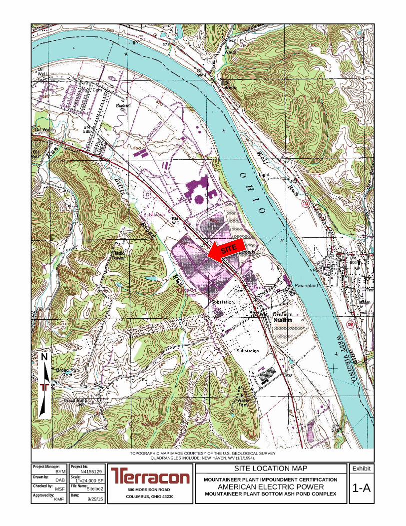
SITE LOCATION MAPMOUNTAINEER PLANT IMPOUNDMENT CERTIFICATION
AMERICAN ELECTRIC POWERMOUNTAINEER PLANT BOTTOM ASH POND COMPLEX
TOPOGRAPHIC MAP IMAGE COURTESY OF THE U.S. GEOLOGICAL SURVEYQUADRANGLES INCLUDE: NEW HAVEN, WV (1/1/1994).
800 MORRISON ROADCOLUMBUS, OHIO 43230
N4155129Project Manager:
Drawn by:
Checked by:
Approved by:
DAB
MSF
KME
1”=24,000 SF
Siteloc2
9/29/15
Project No.
Scale:
File Name:
Date:
ExhibitBYM
1-A

SITE LOCATION MAPMOUNTAINEER PLANT IMPOUNDMENT CERTIFICATION
AMERICAN ELECTRIC POWERMOUNTAINEER PLANT BOTTOM ASH POND COMPLEX
800 MORRISON ROADCOLUMBUS, OHIO 43230
DIAGRAM IS FOR GENERAL LOCATION ONLY, AND ISNOT INTENDED FOR CONSTRUCTION PURPOSES
N4155129
AERIAL PHOTOGRAPHY PROVIDEDBY MICROSOFT BING MAPS
DAB
MSF
KME
AS SHOWN
Siteloc2
9/29/15
Scale:
ExhibitProject Manager:
Drawn by:
Checked by:
Approved by:
Project No.
File Name:
Date:
BYM
1-B

SCALE IN FEET
0300 300150
DESI
GNED
BY:
SCAL
E:AP
PVD.
BY:
DRAW
N BY
:
DATE
:
SHEE
T NO
.:
JOB
NO.
OF
BYDE
SCRI
PTIO
NDA
TERE
V.
ACAD
NO.
800 M
ORRI
SON
ROAD
COLU
MBUS
, OHI
O 43
230
FAX.
(614
) 863
-047
5PH
. (61
4) 86
3-31
13
Co
nsu
ltin
g E
ng
in
ee
rs a
nd
S
cie
ntists
EXHI
BIT
2
1"=3
00'
9/29/1
5N4
1551
29SE
T1
SITE
PLA
NMO
UNTA
INEE
R PL
ANT
IMPO
UNDM
ENT
CERT
IFIC
ATIO
NAM
ERIC
AN E
LECT
RIC
POW
ERMO
UNTA
INEE
R PL
ANT
BOTT
OM A
SH P
OND
COMP
LEX
NEW
HAV
EN, M
ASON
COU
NTY
WV
MSF
DAB
BMY
32
NOTE
THE AERIAL TOPOGRAPHY WAS OBTAINED FROM HENDERSON AERIAL
SURVEYS INC., DATED 3/20/2012.
EAST BOTTOM
ASH POND
EAST
WASTEWATER
POND
CLEARWATER
POND
WEST BOTTOM
ASH POND
WEST
WASTEWATER
POND
RECLAIM
POND
STATE HIGHWAY 33
bmyahaya
Polygon
bmyahaya
Polygon
bmyahaya
Polygon
bmyahaya
Polygon
bmyahaya
Typewriter
POND DRAINAGE AREA

DESI
GNED
BY:
SCAL
E:AP
PVD.
BY:
DRAW
N BY
:
DATE
:
SHEE
T NO
.:
JOB
NO.
OF
BYDE
SCRI
PTIO
NDA
TERE
V.
ACAD
NO.
800 M
ORRI
SON
ROAD
COLU
MBUS
, OHI
O 43
230
FAX.
(614
) 863
-047
5PH
. (61
4) 86
3-31
13
Co
nsu
ltin
g E
ng
in
ee
rs a
nd
S
cie
ntists
EXHI
BIT
3
NTS
9/30/1
5N4
1551
29SE
T1
POND
SCH
EMAT
IC
MSF
DAB
BMY
33
EAST BOTTOM ASH POND EAST WASTEWATER POND CLEARWATER POND
EL. 620.0 EL. 620.0
EL. 612.0
EL. 610.0
NOTE:
EMBANKMENT CREST ELEVATIONS AND NORMAL OPERATINGPOOL LEVELS SHOWN TAKEN FROM AEP PROVIDED DRAWINGS1-3018A-7, 1-3018B-8, AND 1-3018C-5, CONTAININGSECTIONS AND DETAILS FOR THE POND COMPLEX.
LEGEND
MAX. RESULTANT POOLLEVELS DURING THEDESIGN STORM
NORMAL OPERATING POOL LEVELS603.0
613.3
613.3
612.0
609.3609.0
603.0
MOUN
TAIN
EER
PLAN
T IM
POUN
DMEN
T CE
RTIF
ICAT
ION
AMER
ICAN
ELE
CTRI
C PO
WER
MOUN
TAIN
EER
PLAN
T BO
TTOM
ASH
PON
D CO
MPLE
X
NEW
HAV
EN, M
ASON
COU
NTY
WV
603.6

Hydrologic and Hydraulic Analysis and P.E. Certification Mountaineer Plant Impoundment ■ New Haven, West Virginia September 30, 2015 ■ Terracon Project No. N4155129
Responsive ■ Resourceful ■ Reliable
ATTACHMENT 1
Pumped Influent and Water Balance Information

Hydrologic and Hydraulic Analysis and P.E. Certification
Mountaineer Plant Impoundment ■ New Haven, West Virginia
Semtember 30, 2015 ■ Terracon Project No. N4155129
Influent Sources Rate (mgd) cfs
To Bottom Ash Pond
Coal Pile Run-off 1.23
Fly Ash Silo Sumps 3.12
Stormwater 4.37
Turbine Room Sump 1.84
Pyrites Transport 1.28
Bottom Ash Transport 3.12
Total 14.96 24
To Wastewater Pond
Water Treatment Sump 2.29
Cooling Tower Blowdown 1.58
Total 3.87 6
To Bottom Ash Pond
Bioreactor 0.86 2
Note:
Influent pumped is compiled from the attached water balance data provided by AEP.
Mountaineer Plant Impoundment System
Pumped Influent
Resourceful ■ Responsive ■ Reliable

Revision date 12/28/2012 - Drawing is intended to communicate water flow for NPDES Permitting purposes.Not to be used for any other purposes. All flows measured in million gallons per day (MGD)
Ohio River
River WaterMake-up
Dry Fly Ash
Conditioning
001
CoolingTower
CoolingTower
Blowdown
Evaporation/ Drift
North / SouthFly Ash
SiloSumps
BottomAsh
Transport
Little Broad RunRun-off
Collection Pond
WastewaterTreatmentPonds (2)
ClearwaterPond
Reclaim WaterPond
WaterTreatment
Sump
StormWater
Run-off
Emergency Overflows & Drains
fromCondensate & Fire Protection Tanks
Bottom AshPonds (2)
PyritesTransport
Coal PileRun-off
Metal CleaningWaste Treatment Tank
(intermittent)
Cycle Loss
0.075
0.058
1.58
0.36
TurbineRoomSump
0.171.23 (max)
1.281.84
3.123.12
2.29
9.5313.42(max)
13.67 19.23(max)
4.31
10.39(max)
4.79
11.61(max)
9.36
18.74
11.62
Flue GasDesulfurization
Evaporation
2.5
0.1Gypsumsludge
Limestone PileRun-off
Gypsum PileRun-off
0.0010.03 (max)
Rainfall1.67(max)
Rainfall0.52
(max)
101
0.74 (max)0.003 0.08 (max)
Rainfall2.83(max)
0.48
0.02
0.50
Sludge
AOD System Recycle Tank(intermittent)
Rainfall
AOD System Recycle Tank(intermittent)
CPSTreatment
Facility
0.04
Bioreactor
0.86
LeachateSurgePond
AppalachianPower Co.
Mountaineer PlantWater BalanceFlow Diagram
### Outlet Number
LEGEND
Supply Water
Waste Water
Reclaim Water
Storm Water
Evaporation/Rainfall
No flow associatedwith normaloperating conditions(emergency overflow)
NOTESNote 1: All flows represent average water usage with the unit operating at full load.
Note 2: Maximum (max) flows include rainfall for a 10-year/24-hour storm event.
Note 3: Maximum (max) flow entering the Storm Water Pumping Station (SWPS) is the 24 hours of highest intensity in a 10 year/24-hour storm event.
Note 4: The design overflow of the SWPS to the River Water Make-up is anything over a 1” storm in a 24-hour period.
Note 5: Proposed storm water management modifications indicated in GREEN, and proposed storm water management terminations indicated in RED.
ProposedStormWater
PumpingStation
5.68(max)
1.31(max)
4.37 (max)
Fire SuppressionFlush Water
Little Broad Run
017
StormWater
Run-off
StormWater
Run-off
014 015
StormWater
Run-off
ProposedStormWaterPond
StormWater
Run-off
003
StormWater
Run-off
013
StormWater
Run-off
StormWater
Run-off
016 018006
StormWater
Run-off
StormWater
Run-off
008
StormWater
Run-off
StormWater
Run-off
StormWater
Run-off
009 010
StormWater
Run-off
011
004
005
0.0620.003Ohio River0080.1340.006Ohio River0090.0290.001Ohio River0100.2160.009Ohio River0110.2730.012Ohio River0130.0260.001Little Broad Run0140.2520.011Little Broad Run0150.0980.004Ohio River0160.0640.002Little Broad Run0170.024
0.4587.2382.6053.97811.61
Maximum Discharge
0.001
0.0190.3070.1100.1694.79
Average Discharge
Ohio River
Ohio RiverOhio RiverOhio River
Little Broad RunOhio River
Receiving Water
018
006005004003001
Outlet Number

Hydrologic and Hydraulic Analysis and P.E. Certification Mountaineer Plant Impoundment ■ New Haven, West Virginia September 30, 2015 ■ Terracon Project No. N4155129
Responsive ■ Resourceful ■ Reliable
ATTACHMENT 2
Precipitation Data

NOAA Atlas 14, Volume 2, Version 3Location name: Letart, West Virginia, US*Latitude: 38.9697°, Longitude: -81.9364°
Elevation: 621 ft** source: Google Maps
POINT PRECIPITATION FREQUENCY ESTIMATES
G.M. Bonnin, D. Martin, B. Lin, T. Parzybok, M.Yekta, and D. Riley
NOAA, National Weather Service, Silver Spring, Maryland
PF_tabular | PF_graphical | Maps_&_aerials
PF tabularPDS-based point precipitation frequency estimates with 90% confidence intervals (in inches)1
DurationAverage recurrence interval (years)
1 2 5 10 25 50 100 200 500 1000
5-min 0.337(0.305-0.371)
0.401(0.364-0.442)
0.481(0.436-0.530)
0.542(0.491-0.597)
0.619(0.558-0.680)
0.677(0.610-0.742)
0.732(0.656-0.801)
0.786(0.703-0.859)
0.857(0.761-0.934)
0.907(0.803-0.988)
10-min 0.523(0.474-0.576)
0.625(0.568-0.691)
0.747(0.678-0.824)
0.837(0.758-0.921)
0.947(0.854-1.04)
1.03(0.924-1.13)
1.10(0.988-1.21)
1.17(1.05-1.28)
1.26(1.12-1.37)
1.32(1.17-1.44)
15-min 0.641(0.581-0.706)
0.765(0.694-0.845)
0.917(0.832-1.01)
1.03(0.933-1.13)
1.17(1.06-1.29)
1.27(1.14-1.39)
1.37(1.23-1.50)
1.46(1.31-1.60)
1.57(1.40-1.71)
1.65(1.46-1.80)
30-min 0.848(0.769-0.934)
1.02(0.929-1.13)
1.26(1.14-1.39)
1.43(1.30-1.57)
1.65(1.49-1.81)
1.82(1.64-1.99)
1.98(1.77-2.16)
2.13(1.90-2.33)
2.33(2.07-2.54)
2.48(2.19-2.70)
60-min 1.04(0.939-1.14)
1.26(1.14-1.39)
1.58(1.43-1.74)
1.82(1.65-2.00)
2.14(1.93-2.35)
2.39(2.15-2.62)
2.64(2.37-2.89)
2.89(2.58-3.16)
3.22(2.86-3.51)
3.48(3.08-3.79)
2-hr 1.21(1.10-1.33)
1.46(1.33-1.61)
1.84(1.67-2.02)
2.13(1.92-2.33)
2.52(2.27-2.76)
2.84(2.55-3.10)
3.16(2.82-3.45)
3.50(3.11-3.80)
3.95(3.48-4.28)
4.31(3.78-4.66)
3-hr 1.28(1.16-1.41)
1.54(1.40-1.70)
1.93(1.76-2.13)
2.24(2.03-2.47)
2.66(2.41-2.92)
3.00(2.70-3.29)
3.36(3.01-3.67)
3.72(3.31-4.06)
4.23(3.73-4.60)
4.62(4.06-5.02)
6-hr 1.52(1.39-1.67)
1.82(1.67-2.01)
2.26(2.07-2.49)
2.62(2.39-2.87)
3.12(2.83-3.41)
3.54(3.19-3.85)
3.96(3.56-4.31)
4.41(3.94-4.78)
5.04(4.45-5.44)
5.54(4.86-5.97)
12-hr 1.79(1.65-1.94)
2.13(1.96-2.32)
2.61(2.41-2.85)
3.02(2.78-3.28)
3.59(3.29-3.88)
4.06(3.70-4.38)
4.56(4.13-4.90)
5.08(4.58-5.45)
5.82(5.19-6.23)
6.42(5.68-6.85)
24-hr 2.14(2.01-2.28)
2.55(2.40-2.72)
3.09(2.90-3.29)
3.53(3.31-3.76)
4.14(3.88-4.40)
4.64(4.33-4.92)
5.15(4.79-5.46)
5.68(5.27-6.01)
6.41(5.92-6.77)
6.98(6.42-7.37)
2-day 2.55(2.40-2.71)
3.02(2.85-3.22)
3.63(3.41-3.86)
4.11(3.87-4.37)
4.78(4.48-5.07)
5.31(4.96-5.63)
5.85(5.45-6.20)
6.40(5.95-6.78)
7.16(6.61-7.58)
7.74(7.12-8.19)
3-day 2.74(2.58-2.90)
3.24(3.06-3.45)
3.87(3.65-4.11)
4.37(4.12-4.64)
5.05(4.75-5.35)
5.59(5.24-5.92)
6.13(5.73-6.48)
6.68(6.23-7.07)
7.42(6.88-7.84)
7.98(7.37-8.43)
4-day 2.93(2.77-3.10)
3.46(3.27-3.67)
4.12(3.89-4.37)
4.64(4.38-4.91)
5.33(5.02-5.64)
5.87(5.51-6.21)
6.41(6.01-6.77)
6.96(6.50-7.35)
7.67(7.14-8.10)
8.22(7.63-8.67)
7-day 3.52(3.33-3.72)
4.16(3.94-4.40)
4.90(4.63-5.17)
5.46(5.16-5.76)
6.20(5.85-6.54)
6.76(6.37-7.13)
7.32(6.88-7.71)
7.86(7.37-8.27)
8.56(8.00-9.01)
9.08(8.46-9.57)
10-day 4.03(3.82-4.25)
4.75(4.50-5.01)
5.53(5.24-5.83)
6.12(5.80-6.45)
6.89(6.51-7.25)
7.47(7.05-7.85)
8.02(7.56-8.44)
8.56(8.05-9.00)
9.24(8.67-9.72)
9.73(9.11-10.2)
20-day 5.62(5.34-5.91)
6.59(6.26-6.92)
7.56(7.18-7.94)
8.28(7.87-8.69)
9.20(8.73-9.65)
9.87(9.37-10.4)
10.5(9.96-11.0)
11.1(10.5-11.6)
11.8(11.2-12.4)
12.4(11.7-13.0)
30-day 6.94(6.64-7.26)
8.11(7.76-8.49)
9.20(8.80-9.63)
10.0(9.57-10.5)
11.0(10.5-11.5)
11.8(11.2-12.3)
12.4(11.9-13.0)
13.1(12.4-13.7)
13.8(13.1-14.5)
14.4(13.6-15.0)
45-day 8.87(8.50-9.26)
10.3(9.89-10.8)
11.6(11.1-12.1)
12.5(12.0-13.1)
13.6(13.1-14.2)
14.4(13.8-15.1)
15.2(14.5-15.9)
15.9(15.1-16.6)
16.6(15.9-17.4)
17.2(16.4-18.0)
60-day 10.5(10.1-11.0)
12.2(11.7-12.7)
13.6(13.1-14.2)
14.6(14.0-15.2)
15.8(15.2-16.5)
16.7(16.0-17.4)
17.5(16.7-18.2)
18.1(17.4-18.9)
18.9(18.1-19.7)
19.5(18.6-20.3)
1 Precipitation frequency (PF) estimates in this table are based on frequency analysis of partial duration series (PDS).Numbers in parenthesis are PF estimates at lower and upper bounds of the 90% confidence interval. The probability that precipitation frequency estimates (for agiven duration and average recurrence interval) will be greater than the upper bound (or less than the lower bound) is 5%. Estimates at upper bounds are notchecked against probable maximum precipitation (PMP) estimates and may be higher than currently valid PMP values.Please refer to NOAA Atlas 14 document for more information.
Back to Top
PF graphical
Page 1 of 3Precipitation Frequency Data Server
7/21/2015http://dipper.nws.noaa.gov/hdsc/pfds/pfds_printpage.html?lat=38.9697&lon=-81.9364&da...
bmyahaya
Rectangle

Hydrologic and Hydraulic Analysis and P.E. Certification Mountaineer Plant Impoundment ■ New Haven, West Virginia September 30, 2015 ■ Terracon Project No. N4155129
Responsive ■ Resourceful ■ Reliable
ATTACHMENT 3
PondPack Model Output

Scenario: Post-Development 1000 Year
9/30/2015
Page 1 of 127 Siemon Company Drive Suite 200 W Watertown, CT 06795 USA+1-203-755-1666Mountaineer Plant Impoundment.ppc
Bentley PondPack V8i[08.11.01.56]Bentley Systems, Inc. Haestad Methods Solution CenterMountaineer Plant Botton Ash Complex

Table of Contents
24Outlet Input Data, 1,000 years
Wastewater Pond Outlet
20Outlet Input Data, 1,000 years
Clearwater Pond Outlet
17Outlet Input Data, 1,000 years
Bottom Ash Pond Outlet
16Elevation-Area Volume Curve, 1,000 years
Wastewater Pond (WWP)
15Elevation-Area Volume Curve, 1,000 years
Clearwater Pond (CWP)
14Elevation-Area Volume Curve, 1,000 years
Bottom Ash Pond (BAP)
12Read Hydrograph, 1,000 years
WWP Influent Pumped
10Unit Hydrograph Summary, 1,000 years
Wastewater Pond Catchment
8Read Hydrograph, 1,000 years
CWP Influent Pumped
6Unit Hydrograph Summary, 1,000 years
Clearwater Pond Catchment
4Unit Hydrograph Summary, 1,000 years
Bottom Ash Pond Catchment
2Read Hydrograph, 1,000 years
BAP Influent Pumped
1Master Network Summary

Subsection: Master Network Summary
Catchments Summary
Peak Flow(ft³/s)
Time to Peak(hours)
HydrographVolume(ac-ft)
ReturnEvent
(years)
ScenarioLabel
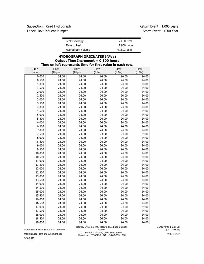
24.000.00047.6031,000Post-Development1000 Year
BAP Influent Pumped
143.8011.9009.3001,000Post-Development1000 Year
Bottom Ash PondCatchment
2.000.0003.9671,000Post-Development1000 Year
CWP Influent Pumped
76.8611.9505.2301,000Post-Development1000 Year
Clearwater PondCatchment
6.000.00011.9011,000Post-Development1000 Year
WWP Influent Pumped
89.6711.9506.1021,000Post-Development1000 Year
Wastewater PondCatchment
Node Summary
Peak Flow(ft³/s)
Time to Peak(hours)
HydrographVolume(ac-ft)
ReturnEvent
(years)
ScenarioLabel
77.0712.35073.6551,000Post-Development1000 Year
CWP Outfall
Pond Summary
MaximumPond Storage
(ac-ft)
MaximumWater
SurfaceElevation
(ft)
Peak Flow(ft³/s)
Time to Peak(hours)
HydrographVolume(ac-ft)
ReturnEvent
(years)
ScenarioLabel
(N/A)(N/A)167.8011.90056.9031,000Post-Development1000 Year
Bottom AshPond (BAP)(IN)
16.505613.2537.7412.40050.5081,000Post-Development1000 Year
Bottom AshPond (BAP)(OUT)
(N/A)(N/A)168.1211.95074.8601,000Post-Development1000 Year
ClearwaterPond (CWP)(IN)
3.877603.5577.0712.35073.6551,000Post-Development1000 Year
ClearwaterPond (CWP)(OUT)
(N/A)(N/A)129.6711.95068.5111,000Post-Development1000 Year
WastewaterPond (WWP)(IN)
3.775609.29100.2412.05065.6631,000Post-Development1000 Year
WastewaterPond (WWP)(OUT)
9/30/2015
Page 1 of 2727 Siemon Company Drive Suite 200 WWatertown, CT 06795 USA +1-203-755-1666
Mountaineer Plant Impoundment.ppc
Bentley PondPack V8i[08.11.01.56]
Bentley Systems, Inc. Haestad Methods SolutionCenterMountaineer Plant Botton Ash Complex
Storm Event: 1000 YearLabel: BAP Influent Pumped
Return Event: 1,000 yearsSubsection: Read Hydrograph
ft³/s24.00Peak Discharge
hours7.900Time to Peak
ac-ft47.603Hydrograph Volume
HYDROGRAPH ORDINATES (ft³/s)Output Time Increment = 0.100 hours
Time on left represents time for first value in each row.Flow
(ft³/s)Flow
(ft³/s)Flow
(ft³/s)Flow
(ft³/s)Flow
(ft³/s)Time
(hours)
24.0024.0024.0024.0024.000.000
24.0024.0024.0024.0024.000.500
24.0024.0024.0024.0024.001.000
24.0024.0024.0024.0024.001.500
24.0024.0024.0024.0024.002.000
24.0024.0024.0024.0024.002.500
24.0024.0024.0024.0024.003.000
24.0024.0024.0024.0024.003.500
24.0024.0024.0024.0024.004.000
24.0024.0024.0024.0024.004.500
24.0024.0024.0024.0024.005.000
24.0024.0024.0024.0024.005.500
24.0024.0024.0024.0024.006.000
24.0024.0024.0024.0024.006.500
24.0024.0024.0024.0024.007.000
24.0024.0024.0024.0024.007.500
24.0024.0024.0024.0024.008.000
24.0024.0024.0024.0024.008.500
24.0024.0024.0024.0024.009.000
24.0024.0024.0024.0024.009.500
24.0024.0024.0024.0024.0010.000
24.0024.0024.0024.0024.0010.500
24.0024.0024.0024.0024.0011.000
24.0024.0024.0024.0024.0011.500
24.0024.0024.0024.0024.0012.000
24.0024.0024.0024.0024.0012.500
24.0024.0024.0024.0024.0013.000
24.0024.0024.0024.0024.0013.500
24.0024.0024.0024.0024.0014.000
24.0024.0024.0024.0024.0014.500
24.0024.0024.0024.0024.0015.000
24.0024.0024.0024.0024.0015.500
24.0024.0024.0024.0024.0016.000
24.0024.0024.0024.0024.0016.500
24.0024.0024.0024.0024.0017.000
24.0024.0024.0024.0024.0017.500
24.0024.0024.0024.0024.0018.000
24.0024.0024.0024.0024.0018.500
24.0024.0024.0024.0024.0019.000
9/30/2015
Page 2 of 2727 Siemon Company Drive Suite 200 WWatertown, CT 06795 USA +1-203-755-1666
Mountaineer Plant Impoundment.ppc
Bentley PondPack V8i[08.11.01.56]
Bentley Systems, Inc. Haestad Methods SolutionCenterMountaineer Plant Botton Ash Complex

Storm Event: 1000 YearLabel: BAP Influent Pumped
Return Event: 1,000 yearsSubsection: Read Hydrograph
HYDROGRAPH ORDINATES (ft³/s)Output Time Increment = 0.100 hours
Time on left represents time for first value in each row.Flow
(ft³/s)Flow
(ft³/s)Flow
(ft³/s)Flow
(ft³/s)Flow
(ft³/s)Time
(hours)
24.0024.0024.0024.0024.0019.500
24.0024.0024.0024.0024.0020.000
24.0024.0024.0024.0024.0020.500
24.0024.0024.0024.0024.0021.000
24.0024.0024.0024.0024.0021.500
24.0024.0024.0024.0024.0022.000
24.0024.0024.0024.0024.0022.500
24.0024.0024.0024.0024.0023.000
24.0024.0024.0024.0024.0023.500
(N/A)(N/A)(N/A)(N/A)24.0024.000
9/30/2015
Page 3 of 2727 Siemon Company Drive Suite 200 WWatertown, CT 06795 USA +1-203-755-1666
Mountaineer Plant Impoundment.ppc
Bentley PondPack V8i[08.11.01.56]
Bentley Systems, Inc. Haestad Methods SolutionCenterMountaineer Plant Botton Ash Complex

Storm Event: 1000 YearLabel: Bottom Ash Pond Catchment
Return Event: 1,000 yearsSubsection: Unit Hydrograph Summary
1000 YearStorm Event
years1,000Return Event
hours24.000Duration
in7.0Depth
hours0.083Time of Concentration(Composite)
acres16.000Area (User Defined)
hours0.011Computational TimeIncrement
hours11.911Time to Peak (Computed)
ft³/s146.03Flow (Peak, Computed)
hours0.050Output Increment
hours11.900Time to Flow (PeakInterpolated Output)
ft³/s143.80Flow (Peak InterpolatedOutput)
Drainage Area
100.000SCS CN (Composite)
acres16.000Area (User Defined)
in0.0Maximum Retention(Pervious)
in0.0Maximum Retention(Pervious, 20 percent)
Cumulative Runoff
in7.0Cumulative Runoff Depth(Pervious)
ac-ft9.307Runoff Volume (Pervious)
Hydrograph Volume (Area under Hydrograph curve)
ac-ft9.300Volume
SCS Unit Hydrograph Parameters
hours0.083Time of Concentration(Composite)
hours0.011Computational TimeIncrement
483.432Unit Hydrograph ShapeFactor
0.749K Factor
1.670Receding/Rising, Tr/Tp
ft³/s217.54Unit peak, qp
hours0.056Unit peak time, Tp
9/30/2015
Page 4 of 2727 Siemon Company Drive Suite 200 WWatertown, CT 06795 USA +1-203-755-1666
Mountaineer Plant Impoundment.ppc
Bentley PondPack V8i[08.11.01.56]
Bentley Systems, Inc. Haestad Methods SolutionCenterMountaineer Plant Botton Ash Complex

Storm Event: 1000 YearLabel: Bottom Ash Pond Catchment
Return Event: 1,000 yearsSubsection: Unit Hydrograph Summary
SCS Unit Hydrograph Parameters
hours0.222Unit receding limb, Tr
hours0.278Total unit time, Tb
9/30/2015
Page 5 of 2727 Siemon Company Drive Suite 200 WWatertown, CT 06795 USA +1-203-755-1666
Mountaineer Plant Impoundment.ppc
Bentley PondPack V8i[08.11.01.56]
Bentley Systems, Inc. Haestad Methods SolutionCenterMountaineer Plant Botton Ash Complex

Storm Event: 1000 YearLabel: Clearwater Pond Catchment
Return Event: 1,000 yearsSubsection: Unit Hydrograph Summary
1000 YearStorm Event
years1,000Return Event
hours24.000Duration
in7.0Depth
hours0.100Time of Concentration(Composite)
acres9.000Area (User Defined)
hours0.013Computational TimeIncrement
hours11.920Time to Peak (Computed)
ft³/s79.77Flow (Peak, Computed)
hours0.050Output Increment
hours11.950Time to Flow (PeakInterpolated Output)
ft³/s76.86Flow (Peak InterpolatedOutput)
Drainage Area
100.000SCS CN (Composite)
acres9.000Area (User Defined)
in0.0Maximum Retention(Pervious)
in0.0Maximum Retention(Pervious, 20 percent)
Cumulative Runoff
in7.0Cumulative Runoff Depth(Pervious)
ac-ft5.235Runoff Volume (Pervious)
Hydrograph Volume (Area under Hydrograph curve)
ac-ft5.230Volume
SCS Unit Hydrograph Parameters
hours0.100Time of Concentration(Composite)
hours0.013Computational TimeIncrement
483.432Unit Hydrograph ShapeFactor
0.749K Factor
1.670Receding/Rising, Tr/Tp
ft³/s101.97Unit peak, qp
hours0.067Unit peak time, Tp
9/30/2015
Page 6 of 2727 Siemon Company Drive Suite 200 WWatertown, CT 06795 USA +1-203-755-1666
Mountaineer Plant Impoundment.ppc
Bentley PondPack V8i[08.11.01.56]
Bentley Systems, Inc. Haestad Methods SolutionCenterMountaineer Plant Botton Ash Complex

Storm Event: 1000 YearLabel: Clearwater Pond Catchment
Return Event: 1,000 yearsSubsection: Unit Hydrograph Summary
SCS Unit Hydrograph Parameters
hours0.267Unit receding limb, Tr
hours0.333Total unit time, Tb
9/30/2015
Page 7 of 2727 Siemon Company Drive Suite 200 WWatertown, CT 06795 USA +1-203-755-1666
Mountaineer Plant Impoundment.ppc
Bentley PondPack V8i[08.11.01.56]
Bentley Systems, Inc. Haestad Methods SolutionCenterMountaineer Plant Botton Ash Complex

Storm Event: 1000 YearLabel: CWP Influent Pumped
Return Event: 1,000 yearsSubsection: Read Hydrograph
ft³/s2.00Peak Discharge
hours7.900Time to Peak
ac-ft3.967Hydrograph Volume
HYDROGRAPH ORDINATES (ft³/s)Output Time Increment = 0.100 hours
Time on left represents time for first value in each row.Flow
(ft³/s)Flow
(ft³/s)Flow
(ft³/s)Flow
(ft³/s)Flow
(ft³/s)Time
(hours)
2.002.002.002.002.000.000
2.002.002.002.002.000.500
2.002.002.002.002.001.000
2.002.002.002.002.001.500
2.002.002.002.002.002.000
2.002.002.002.002.002.500
2.002.002.002.002.003.000
2.002.002.002.002.003.500
2.002.002.002.002.004.000
2.002.002.002.002.004.500
2.002.002.002.002.005.000
2.002.002.002.002.005.500
2.002.002.002.002.006.000
2.002.002.002.002.006.500
2.002.002.002.002.007.000
2.002.002.002.002.007.500
2.002.002.002.002.008.000
2.002.002.002.002.008.500
2.002.002.002.002.009.000
2.002.002.002.002.009.500
2.002.002.002.002.0010.000
2.002.002.002.002.0010.500
2.002.002.002.002.0011.000
2.002.002.002.002.0011.500
2.002.002.002.002.0012.000
2.002.002.002.002.0012.500
2.002.002.002.002.0013.000
2.002.002.002.002.0013.500
2.002.002.002.002.0014.000
2.002.002.002.002.0014.500
2.002.002.002.002.0015.000
2.002.002.002.002.0015.500
2.002.002.002.002.0016.000
2.002.002.002.002.0016.500
2.002.002.002.002.0017.000
2.002.002.002.002.0017.500
2.002.002.002.002.0018.000
2.002.002.002.002.0018.500
2.002.002.002.002.0019.000
9/30/2015
Page 8 of 2727 Siemon Company Drive Suite 200 WWatertown, CT 06795 USA +1-203-755-1666
Mountaineer Plant Impoundment.ppc
Bentley PondPack V8i[08.11.01.56]
Bentley Systems, Inc. Haestad Methods SolutionCenterMountaineer Plant Botton Ash Complex

Storm Event: 1000 YearLabel: CWP Influent Pumped
Return Event: 1,000 yearsSubsection: Read Hydrograph
HYDROGRAPH ORDINATES (ft³/s)Output Time Increment = 0.100 hours
Time on left represents time for first value in each row.Flow
(ft³/s)Flow
(ft³/s)Flow
(ft³/s)Flow
(ft³/s)Flow
(ft³/s)Time
(hours)
2.002.002.002.002.0019.500
2.002.002.002.002.0020.000
2.002.002.002.002.0020.500
2.002.002.002.002.0021.000
2.002.002.002.002.0021.500
2.002.002.002.002.0022.000
2.002.002.002.002.0022.500
2.002.002.002.002.0023.000
2.002.002.002.002.0023.500
(N/A)(N/A)(N/A)(N/A)2.0024.000
9/30/2015
Page 9 of 2727 Siemon Company Drive Suite 200 WWatertown, CT 06795 USA +1-203-755-1666
Mountaineer Plant Impoundment.ppc
Bentley PondPack V8i[08.11.01.56]
Bentley Systems, Inc. Haestad Methods SolutionCenterMountaineer Plant Botton Ash Complex

Storm Event: 1000 YearLabel: Wastewater Pond Catchment
Return Event: 1,000 yearsSubsection: Unit Hydrograph Summary
1000 YearStorm Event
years1,000Return Event
hours24.000Duration
in7.0Depth
hours0.100Time of Concentration(Composite)
acres10.500Area (User Defined)
hours0.013Computational TimeIncrement
hours11.920Time to Peak (Computed)
ft³/s93.07Flow (Peak, Computed)
hours0.050Output Increment
hours11.950Time to Flow (PeakInterpolated Output)
ft³/s89.67Flow (Peak InterpolatedOutput)
Drainage Area
100.000SCS CN (Composite)
acres10.500Area (User Defined)
in0.0Maximum Retention(Pervious)
in0.0Maximum Retention(Pervious, 20 percent)
Cumulative Runoff
in7.0Cumulative Runoff Depth(Pervious)
ac-ft6.108Runoff Volume (Pervious)
Hydrograph Volume (Area under Hydrograph curve)
ac-ft6.102Volume
SCS Unit Hydrograph Parameters
hours0.100Time of Concentration(Composite)
hours0.013Computational TimeIncrement
483.432Unit Hydrograph ShapeFactor
0.749K Factor
1.670Receding/Rising, Tr/Tp
ft³/s118.97Unit peak, qp
hours0.067Unit peak time, Tp
9/30/2015
Page 10 of 2727 Siemon Company Drive Suite 200 WWatertown, CT 06795 USA +1-203-755-1666
Mountaineer Plant Impoundment.ppc
Bentley PondPack V8i[08.11.01.56]
Bentley Systems, Inc. Haestad Methods SolutionCenterMountaineer Plant Botton Ash Complex

Storm Event: 1000 YearLabel: Wastewater Pond Catchment
Return Event: 1,000 yearsSubsection: Unit Hydrograph Summary
SCS Unit Hydrograph Parameters
hours0.267Unit receding limb, Tr
hours0.333Total unit time, Tb
9/30/2015
Page 11 of 2727 Siemon Company Drive Suite 200 WWatertown, CT 06795 USA +1-203-755-1666
Mountaineer Plant Impoundment.ppc
Bentley PondPack V8i[08.11.01.56]
Bentley Systems, Inc. Haestad Methods SolutionCenterMountaineer Plant Botton Ash Complex

Storm Event: 1000 YearLabel: WWP Influent Pumped
Return Event: 1,000 yearsSubsection: Read Hydrograph
ft³/s6.00Peak Discharge
hours7.900Time to Peak
ac-ft11.901Hydrograph Volume
HYDROGRAPH ORDINATES (ft³/s)Output Time Increment = 0.100 hours
Time on left represents time for first value in each row.Flow
(ft³/s)Flow
(ft³/s)Flow
(ft³/s)Flow
(ft³/s)Flow
(ft³/s)Time
(hours)
6.006.006.006.006.000.000
6.006.006.006.006.000.500
6.006.006.006.006.001.000
6.006.006.006.006.001.500
6.006.006.006.006.002.000
6.006.006.006.006.002.500
6.006.006.006.006.003.000
6.006.006.006.006.003.500
6.006.006.006.006.004.000
6.006.006.006.006.004.500
6.006.006.006.006.005.000
6.006.006.006.006.005.500
6.006.006.006.006.006.000
6.006.006.006.006.006.500
6.006.006.006.006.007.000
6.006.006.006.006.007.500
6.006.006.006.006.008.000
6.006.006.006.006.008.500
6.006.006.006.006.009.000
6.006.006.006.006.009.500
6.006.006.006.006.0010.000
6.006.006.006.006.0010.500
6.006.006.006.006.0011.000
6.006.006.006.006.0011.500
6.006.006.006.006.0012.000
6.006.006.006.006.0012.500
6.006.006.006.006.0013.000
6.006.006.006.006.0013.500
6.006.006.006.006.0014.000
6.006.006.006.006.0014.500
6.006.006.006.006.0015.000
6.006.006.006.006.0015.500
6.006.006.006.006.0016.000
6.006.006.006.006.0016.500
6.006.006.006.006.0017.000
6.006.006.006.006.0017.500
6.006.006.006.006.0018.000
6.006.006.006.006.0018.500
6.006.006.006.006.0019.000
9/30/2015
Page 12 of 2727 Siemon Company Drive Suite 200 WWatertown, CT 06795 USA +1-203-755-1666
Mountaineer Plant Impoundment.ppc
Bentley PondPack V8i[08.11.01.56]
Bentley Systems, Inc. Haestad Methods SolutionCenterMountaineer Plant Botton Ash Complex

Storm Event: 1000 YearLabel: WWP Influent Pumped
Return Event: 1,000 yearsSubsection: Read Hydrograph
HYDROGRAPH ORDINATES (ft³/s)Output Time Increment = 0.100 hours
Time on left represents time for first value in each row.Flow
(ft³/s)Flow
(ft³/s)Flow
(ft³/s)Flow
(ft³/s)Flow
(ft³/s)Time
(hours)
6.006.006.006.006.0019.500
6.006.006.006.006.0020.000
6.006.006.006.006.0020.500
6.006.006.006.006.0021.000
6.006.006.006.006.0021.500
6.006.006.006.006.0022.000
6.006.006.006.006.0022.500
6.006.006.006.006.0023.000
6.006.006.006.006.0023.500
(N/A)(N/A)(N/A)(N/A)6.0024.000
9/30/2015
Page 13 of 2727 Siemon Company Drive Suite 200 WWatertown, CT 06795 USA +1-203-755-1666
Mountaineer Plant Impoundment.ppc
Bentley PondPack V8i[08.11.01.56]
Bentley Systems, Inc. Haestad Methods SolutionCenterMountaineer Plant Botton Ash Complex

Storm Event: 1000 YearLabel: Bottom Ash Pond (BAP)
Return Event: 1,000 yearsSubsection: Elevation-Area Volume Curve
Volume (Total)(ac-ft)
Volume(ac-ft)
A1+A2+sqr(A1*A2)
(acres)
Area(acres)
Planimeter(ft²)
Elevation(ft)
0.0000.0000.00013.0000.0612.00
13.14513.14539.43413.2900.0613.00
26.59213.44840.34313.6060.0614.00
54.38727.79541.69214.1910.0616.00
83.30228.91543.37214.7250.0618.00
113.35130.04945.07415.3260.0620.00
9/30/2015
Page 14 of 2727 Siemon Company Drive Suite 200 WWatertown, CT 06795 USA +1-203-755-1666
Mountaineer Plant Impoundment.ppc
Bentley PondPack V8i[08.11.01.56]
Bentley Systems, Inc. Haestad Methods SolutionCenterMountaineer Plant Botton Ash Complex

Storm Event: 1000 YearLabel: Clearwater Pond (CWP)
Return Event: 1,000 yearsSubsection: Elevation-Area Volume Curve
Volume (Total)(ac-ft)
Volume(ac-ft)
A1+A2+sqr(A1*A2)
(acres)
Area(acres)
Planimeter(ft²)
Elevation(ft)
0.0000.0000.0006.9000.0603.00
4.9204.92021.0877.1590.0603.70
7.0752.15521.5517.2090.0604.00
21.85314.77822.1677.5710.0606.00
37.35215.49823.2487.9290.0608.00
53.57816.22624.3408.2990.0610.00
9/30/2015
Page 15 of 2727 Siemon Company Drive Suite 200 WWatertown, CT 06795 USA +1-203-755-1666
Mountaineer Plant Impoundment.ppc
Bentley PondPack V8i[08.11.01.56]
Bentley Systems, Inc. Haestad Methods SolutionCenterMountaineer Plant Botton Ash Complex

Storm Event: 1000 YearLabel: Wastewater Pond (WWP)
Return Event: 1,000 yearsSubsection: Elevation-Area Volume Curve
Volume (Total)(ac-ft)
Volume(ac-ft)
A1+A2+sqr(A1*A2)
(acres)
Area(acres)
Planimeter(ft²)
Elevation(ft)
0.0000.0000.0006.2400.0608.70
8.2758.27519.0966.4920.0610.00
23.94915.67423.5129.2650.0612.00
9/30/2015
Page 16 of 2727 Siemon Company Drive Suite 200 WWatertown, CT 06795 USA +1-203-755-1666
Mountaineer Plant Impoundment.ppc
Bentley PondPack V8i[08.11.01.56]
Bentley Systems, Inc. Haestad Methods SolutionCenterMountaineer Plant Botton Ash Complex

Storm Event: 1000 YearLabel: Bottom Ash Pond Outlet
Return Event: 1,000 yearsSubsection: Outlet Input Data
Requested Pond Water Surface Elevations
ft612.00Minimum (Headwater)
ft0.10Increment (Headwater)
ft620.00Maximum (Headwater)
Outlet Connectivity
E2(ft)
E1(ft)
OutfallDirectionOutlet IDStructure Type
620.00612.00BAPCulvert
ForwardBAP RiserInlet Box
620.00606.67TWForwardBAPCulvert
Culvert-Circular
(N/A)(N/A)TailwaterTailwater Settings
9/30/2015
Page 17 of 2727 Siemon Company Drive Suite 200 WWatertown, CT 06795 USA +1-203-755-1666
Mountaineer Plant Impoundment.ppc
Bentley PondPack V8i[08.11.01.56]
Bentley Systems, Inc. Haestad Methods SolutionCenterMountaineer Plant Botton Ash Complex

Storm Event: 1000 YearLabel: Bottom Ash Pond Outlet
Return Event: 1,000 yearsSubsection: Outlet Input Data
Structure ID: BAP RiserStructure Type: Inlet Box
1Number of Openings
ft612.00Elevation
ft²28.3Orifice Area
0.600Orifice Coefficient
ft9.00Weir Length
(ft^0.5)/s3.00Weir Coefficient
1.000K Reverse
0.000Manning's n
0.000Kev, Charged Riser
FalseWeir Submergence
FalseOrifice H to crest
Structure ID: BAP CulvertStructure Type: Culvert-Circular
1Number of Barrels
in48.0Diameter
ft125.00Length
ft125.00Length (Computed Barrel)
ft/ft0.005Slope (Computed)
Outlet Control Data
0.013Manning's n
0.900Ke
0.005Kb
0.900Kr
ft0.00Convergence Tolerance
Inlet Control Data
Form 1Equation Form
0.0340K
1.5000M
0.0553C
0.5400Y
1.260T1 ratio (HW/D)
1.422T2 ratio (HW/D)
-0.500Slope Correction Factor
9/30/2015
Page 18 of 2727 Siemon Company Drive Suite 200 WWatertown, CT 06795 USA +1-203-755-1666
Mountaineer Plant Impoundment.ppc
Bentley PondPack V8i[08.11.01.56]
Bentley Systems, Inc. Haestad Methods SolutionCenterMountaineer Plant Botton Ash Complex

Storm Event: 1000 YearLabel: Bottom Ash Pond Outlet
Return Event: 1,000 yearsSubsection: Outlet Input Data
Use unsubmerged inlet control 0 equation below T1elevation.Use submerged inlet control 0 equation above T2elevation
In transition zone between unsubmerged and submergedinlet control,interpolate between flows at T1 & T2...
ft611.71T1 Elevation ft³/s87.96T1 Flow
ft612.36T2 Elevation ft³/s100.53T2 Flow
9/30/2015
Page 19 of 2727 Siemon Company Drive Suite 200 WWatertown, CT 06795 USA +1-203-755-1666
Mountaineer Plant Impoundment.ppc
Bentley PondPack V8i[08.11.01.56]
Bentley Systems, Inc. Haestad Methods SolutionCenterMountaineer Plant Botton Ash Complex

Storm Event: 1000 YearLabel: Clearwater Pond Outlet
Return Event: 1,000 yearsSubsection: Outlet Input Data
Requested Pond Water Surface Elevations
ft603.00Minimum (Headwater)
ft0.10Increment (Headwater)
ft610.00Maximum (Headwater)
Outlet Connectivity
E2(ft)
E1(ft)
OutfallDirectionOutlet IDStructure Type
610.00610.00CWPCulvert
ForwardCWP RiserInlet Box
610.00603.00CWPCulvert
ForwardCWP WeirRectangular Weir
610.00588.55TWForwardCWPCulvert
Culvert-Circular
(N/A)(N/A)TailwaterTailwater Settings
9/30/2015
Page 20 of 2727 Siemon Company Drive Suite 200 WWatertown, CT 06795 USA +1-203-755-1666
Mountaineer Plant Impoundment.ppc
Bentley PondPack V8i[08.11.01.56]
Bentley Systems, Inc. Haestad Methods SolutionCenterMountaineer Plant Botton Ash Complex

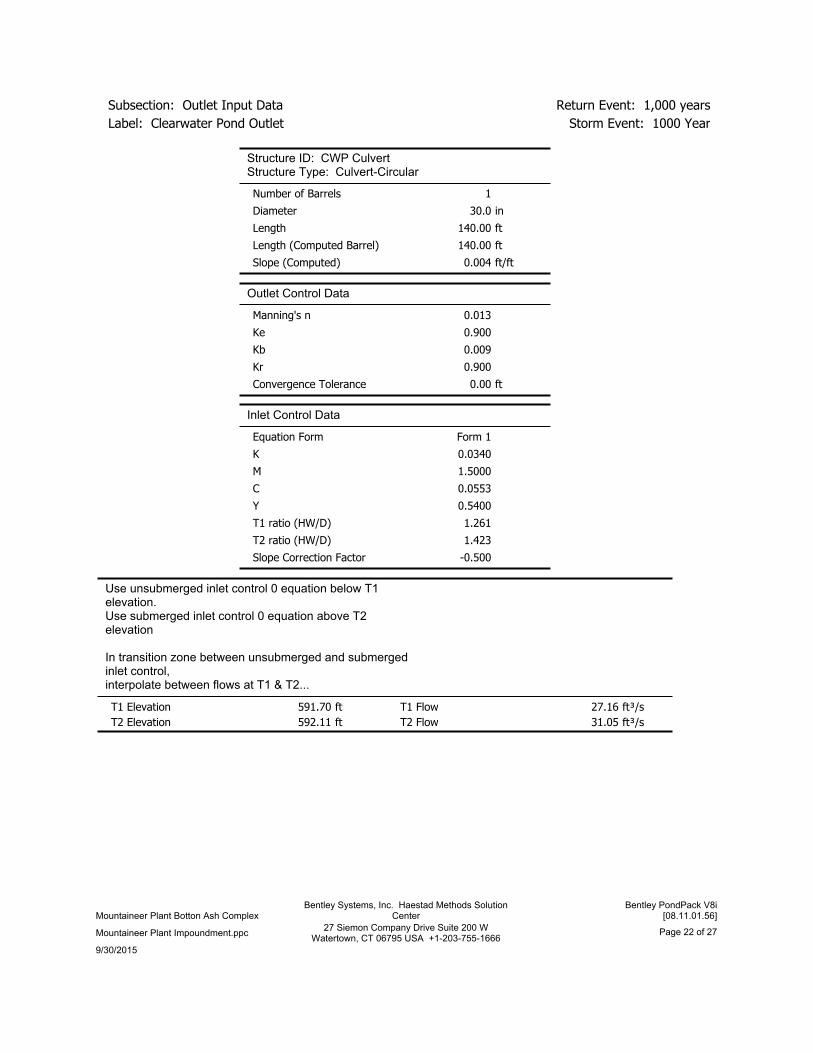
Storm Event: 1000 YearLabel: Clearwater Pond Outlet
Return Event: 1,000 yearsSubsection: Outlet Input Data
Structure ID: CWP RiserStructure Type: Inlet Box
1Number of Openings
ft610.00Elevation
ft²28.3Orifice Area
0.600Orifice Coefficient
ft16.00Weir Length
(ft^0.5)/s3.00Weir Coefficient
1.000K Reverse
0.000Manning's n
0.000Kev, Charged Riser
FalseWeir Submergence
FalseOrifice H to crest
9/30/2015
Page 21 of 2727 Siemon Company Drive Suite 200 WWatertown, CT 06795 USA +1-203-755-1666
Mountaineer Plant Impoundment.ppc
Bentley PondPack V8i[08.11.01.56]
Bentley Systems, Inc. Haestad Methods SolutionCenterMountaineer Plant Botton Ash Complex
Storm Event: 1000 YearLabel: Clearwater Pond Outlet
Return Event: 1,000 yearsSubsection: Outlet Input Data
Structure ID: CWP CulvertStructure Type: Culvert-Circular
1Number of Barrels
in30.0Diameter
ft140.00Length
ft140.00Length (Computed Barrel)
ft/ft0.004Slope (Computed)
Outlet Control Data
0.013Manning's n
0.900Ke
0.009Kb
0.900Kr
ft0.00Convergence Tolerance
Inlet Control Data
Form 1Equation Form
0.0340K
1.5000M
0.0553C
0.5400Y
1.261T1 ratio (HW/D)
1.423T2 ratio (HW/D)
-0.500Slope Correction Factor
Use unsubmerged inlet control 0 equation below T1elevation.Use submerged inlet control 0 equation above T2elevation
In transition zone between unsubmerged and submergedinlet control,interpolate between flows at T1 & T2...
ft591.70T1 Elevation ft³/s27.16T1 Flow
ft592.11T2 Elevation ft³/s31.05T2 Flow
9/30/2015
Page 22 of 2727 Siemon Company Drive Suite 200 WWatertown, CT 06795 USA +1-203-755-1666
Mountaineer Plant Impoundment.ppc
Bentley PondPack V8i[08.11.01.56]
Bentley Systems, Inc. Haestad Methods SolutionCenterMountaineer Plant Botton Ash Complex

Storm Event: 1000 YearLabel: Clearwater Pond Outlet
Return Event: 1,000 yearsSubsection: Outlet Input Data
Structure ID: CWP WeirStructure Type: Rectangular Weir
1Number of Openings
ft603.00Elevation
ft180.00Weir Length
(ft^0.5)/s3.00Weir Coefficient
Structure ID: TWStructure Type: TW Setup, DS Channel
Free OutfallTailwater Type
Convergence Tolerances
30Maximum Iterations
ft0.01Tailwater Tolerance(Minimum)
ft0.50Tailwater Tolerance(Maximum)
ft0.01Headwater Tolerance(Minimum)
ft0.50Headwater Tolerance(Maximum)
ft³/s0.001Flow Tolerance (Minimum)
ft³/s10.000Flow Tolerance (Maximum)
9/30/2015
Page 23 of 2727 Siemon Company Drive Suite 200 WWatertown, CT 06795 USA +1-203-755-1666
Mountaineer Plant Impoundment.ppc
Bentley PondPack V8i[08.11.01.56]
Bentley Systems, Inc. Haestad Methods SolutionCenterMountaineer Plant Botton Ash Complex

Storm Event: 1000 YearLabel: Wastewater Pond Outlet
Return Event: 1,000 yearsSubsection: Outlet Input Data
Requested Pond Water Surface Elevations
ft608.70Minimum (Headwater)
ft0.10Increment (Headwater)
ft612.00Maximum (Headwater)
Outlet Connectivity
E2(ft)
E1(ft)
OutfallDirectionOutlet IDStructure Type
612.00609.00WWPCulvert
Forward +Reverse
WWP WeirRectangular Weir
612.00603.00TWForwardWWPCulvert
Culvert-Box
(N/A)(N/A)TailwaterTailwater Settings
9/30/2015
Page 24 of 2727 Siemon Company Drive Suite 200 WWatertown, CT 06795 USA +1-203-755-1666
Mountaineer Plant Impoundment.ppc
Bentley PondPack V8i[08.11.01.56]
Bentley Systems, Inc. Haestad Methods SolutionCenterMountaineer Plant Botton Ash Complex

Storm Event: 1000 YearLabel: Wastewater Pond Outlet
Return Event: 1,000 yearsSubsection: Outlet Input Data
Structure ID: WWP CulvertStructure Type: Culvert-Box
1Number of Barrels
ft3.00Width
ft4.00Height
ft50.00Length
ft50.00Length (Computed Barrel)
ft/ft0.000Slope (Computed)
Outlet Control Data
0.013Manning's n
0.000Ke
0.006Kb
0.000Kr
ft0.00Convergence Tolerance
Inlet Control Data
Form 2Equation Form
0.5000K
0.6670M
0.0446C
0.6500Y
1.153T1 ratio (HW/D)
1.364T2 ratio (HW/D)
-0.500Slope Correction Factor
Use unsubmerged inlet control 1 equation below T1elevation.Use submerged inlet control 1 equation above T2elevation
In transition zone between unsubmerged and submergedinlet control,interpolate between flows at T1 & T2...
ft607.61T1 Elevation ft³/s84.00T1 Flow
ft608.45T2 Elevation ft³/s96.00T2 Flow
9/30/2015
Page 25 of 2727 Siemon Company Drive Suite 200 WWatertown, CT 06795 USA +1-203-755-1666
Mountaineer Plant Impoundment.ppc
Bentley PondPack V8i[08.11.01.56]
Bentley Systems, Inc. Haestad Methods SolutionCenterMountaineer Plant Botton Ash Complex

Storm Event: 1000 YearLabel: Wastewater Pond Outlet
Return Event: 1,000 yearsSubsection: Outlet Input Data
Structure ID: WWP WeirStructure Type: Rectangular Weir
1Number of Openings
ft609.00Elevation
ft210.00Weir Length
(ft^0.5)/s3.00Weir Coefficient
9/30/2015
Page 26 of 2727 Siemon Company Drive Suite 200 WWatertown, CT 06795 USA +1-203-755-1666
Mountaineer Plant Impoundment.ppc
Bentley PondPack V8i[08.11.01.56]
Bentley Systems, Inc. Haestad Methods SolutionCenterMountaineer Plant Botton Ash Complex

Index
WWP Influent Pumped (Read Hydrograph, 1,000 years)...12, 13
Wastewater Pond Outlet (Outlet Input Data, 1,000 years)...24, 25, 26
Wastewater Pond Catchment (Unit Hydrograph Summary, 1,000 years)...10, 11
Wastewater Pond (WWP) (Elevation-Area Volume Curve, 1,000 years)...16
W
Master Network Summary...1
M
CWP Influent Pumped (Read Hydrograph, 1,000 years)...8, 9
Clearwater Pond Outlet (Outlet Input Data, 1,000 years)...20, 21, 22, 23
Clearwater Pond Catchment (Unit Hydrograph Summary, 1,000 years)...6, 7
Clearwater Pond (CWP) (Elevation-Area Volume Curve, 1,000 years)...15
C
Bottom Ash Pond Outlet (Outlet Input Data, 1,000 years)...17, 18, 19
Bottom Ash Pond Catchment (Unit Hydrograph Summary, 1,000 years)...4, 5
Bottom Ash Pond (BAP) (Elevation-Area Volume Curve, 1,000 years)...14
BAP Influent Pumped (Read Hydrograph, 1,000 years)...2, 3
B
9/30/2015
Page 27 of 2727 Siemon Company Drive Suite 200 WWatertown, CT 06795 USA +1-203-755-1666
Mountaineer Plant Impoundment.ppc
Bentley PondPack V8i[08.11.01.56]
Bentley Systems, Inc. Haestad Methods SolutionCenterMountaineer Plant Botton Ash Complex