
Hydrogeological properties of the UG2 pyroxenite aquifers of the Bushveld Complex
10
The Southern African Institute of Mining and Metallurgy Platinum 2012 143 R. Gebrekristos, P.Cheshire HYDROGEOLOGICAL PROPERTIES OF THE UG2 PYROXENITE AQUIFERS OF THE BUSHVELD COMPLEX R. Gebrekristos Digby Wells Environmental P. Cheshire Groundwater Monitoring Services Abstract It is commonly accepted that three types of aquifers exist in the Bushveld Complex: (a) alluvial aquifers in areas of river courses, (b) weathered bedrock aquifer formed by the in- situ weathering of the bedrocks, (c) fractured aquifers underlying the weathered aquifers controlled by the regional and local fracturing of the crystalline rocks. Hydrogeological studies conducted in the Critical Zone of the Bushveld Complex in the western limb show that the UG2 pyroxenite layer is of a particular interest and has a unique aquifer property. It yields much of the groundwater inflow into some mines and can be classified as the most important aquifer in the vicinity of the mining zone. The UG2 pyroxenite aquifer is restricted to the dipping UG2 pyroxenite unit. The unit weathers more intensely than the surrounding norites and anorthosites and is characterized by deeper weathering horizons (two to three times deeper than the surrounding rocks). For much of the UG2 mining area between depths of 35 – 80 m, stoping of the UG2 takes place approximately 5 – 7 m below the UG2 pyroxenite aquifer, and usually there is no groundwater inflow into the mine workings. However, unsealed deep exploration boreholes intersecting the UG2 pyroxenite and reaching underground mine workings, or mine roofbolts penetrating the weathered pyroxenite aquifer from underneath, can result in significant groundwater inflows into the underground workings. The reason as to why the UG2 pyroxenite weathers more than the norites and anorthosites has not been fully studied but is suspected to be due to the bedding planes of the unit and mineralogical composition of the particular pyroxenes forming the unit, which result in preferential physical and chemical weathering under atmospheric conditions. The weathered pyroxenes form sand-sized, rounded grains with improved effective porosity and permeability suitable for the storage and passage of groundwater. The orientation of the pyroxenite aquifer can easily be determined as it dips with the Bushveld layered strata. No-flow boundaries can be assumed on the hanging- and footwall of the pyroxenite aquifer and the flow rates can be estimated using 2-dimentional analytical equations.
Transcript of Hydrogeological properties of the UG2 pyroxenite aquifers of the Bushveld Complex

The Southern African Institute of Mining and Metallurgy
Platinum 2012
143
R. Gebrekristos, P.Cheshire
HYDROGEOLOGICAL PROPERTIES OF THE UG2 PYROXENITE
AQUIFERS OF THE BUSHVELD COMPLEX
R. Gebrekristos Digby Wells Environmental
P. Cheshire Groundwater Monitoring Services
Abstract
It is commonly accepted that three types of aquifers exist in the Bushveld Complex: (a)
alluvial aquifers in areas of river courses, (b) weathered bedrock aquifer formed by the in-
situ weathering of the bedrocks, (c) fractured aquifers underlying the weathered aquifers
controlled by the regional and local fracturing of the crystalline rocks.
Hydrogeological studies conducted in the Critical Zone of the Bushveld Complex in the
western limb show that the UG2 pyroxenite layer is of a particular interest and has a unique
aquifer property. It yields much of the groundwater inflow into some mines and can be
classified as the most important aquifer in the vicinity of the mining zone.
The UG2 pyroxenite aquifer is restricted to the dipping UG2 pyroxenite unit. The unit
weathers more intensely than the surrounding norites and anorthosites and is characterized
by deeper weathering horizons (two to three times deeper than the surrounding rocks).
For much of the UG2 mining area between depths of 35 – 80 m, stoping of the UG2 takes
place approximately 5 – 7 m below the UG2 pyroxenite aquifer, and usually there is no
groundwater inflow into the mine workings. However, unsealed deep exploration boreholes
intersecting the UG2 pyroxenite and reaching underground mine workings, or mine
roofbolts penetrating the weathered pyroxenite aquifer from underneath, can result in
significant groundwater inflows into the underground workings.
The reason as to why the UG2 pyroxenite weathers more than the norites and anorthosites
has not been fully studied but is suspected to be due to the bedding planes of the unit and
mineralogical composition of the particular pyroxenes forming the unit, which result in
preferential physical and chemical weathering under atmospheric conditions. The
weathered pyroxenes form sand-sized, rounded grains with improved effective porosity and
permeability suitable for the storage and passage of groundwater.
The orientation of the pyroxenite aquifer can easily be determined as it dips with the
Bushveld layered strata. No-flow boundaries can be assumed on the hanging- and footwall
of the pyroxenite aquifer and the flow rates can be estimated using 2-dimentional analytical
equations.
The Southern African Institute of Mining and Metallurgy
Platinum 2012
144
However, this must be confirmed with strong conceptual models since the existence of a
fracture network connecting the pyroxenite aquifer with the overlying weathered and/or
underling fractured aquifers can complicate the system, lowering the accuracy of analytical
models and necessitating the utilization of numerical models.
Introduction
Groundwater conditions and aquifer systems of the Bushveld Complex (BC) have being
studied by various researchers, such as Titus et al., 2009, and their hydraulic properties can
be classified into three types:
• Alluvial aquifers on the banks of river or stream courses
• Weathered bedrock aquifers formed by the in-situ weathering of the BC crystalline
rocks
• Fractured aquifers underlying the weathered aquifers controlled by the regional and
local fracture systems.
The alluvial aquifers are composed of unconsolidated layers of gravel, sand, silt, or clay
deposits. They are often unconfined and are laterally discontinuous, being localized within
the immediate vicinity of the river banks and floodplains. These aquifers are fairly high-
yielding due to their interaction with the surface water bodies, coupled with the relatively
high storage and permeability of the unconsolidated sediments. The permeability is,
however, dependent on the particle size and low-yielding zones have been encountered
based on the clay content.
The upper part of the bedrock is often weathered by chemical and mechanical means to
form a variably permeable, fractured and porous rock mass from surface to depths of
approximately 35 m below ground level. This is a separate aquifer layer with different
hydraulic properties from the overlying alluvial aquifers and underlying fresh crystalline
rocks. The depth of the weathered zone is dependent on the parent rock type and site-
specific physiochemical conditions.
The crystalline rocks below the weathered zone form aquitards (poor aquifers) if no
secondary fractures are developed, due to the insignificant pore spaces between the
individual mineral crystals that are not connected to each other. If secondary fractures
(regional or local) exist, however, high-yielding aquifers can develop and boreholes in these
can provide considerable water. These aquifers are often connected with the weathered
aquifer and have been encountered to depths of 130 - 140 m below ground level.
The objective of this study is to hydrogeologically characterize the UG2 pyroxenite aquifer,
which is part of the weathered aquifer but is of a unique interest as it weathers more than
the surrounding rocks. It also stores and transmits more water than the overlying and
underlying rocks. It weathers faster and is characterized by deeper weathering horizons,
extending up to 80 m below the regional weathering depth. Below approximately 80 m, the
weathering effectively ceases to exist and the aquifer truncates to an impermeable jointing
and layer contacts.
The Southern African Institute of Mining and Metallurgy
Platinum 2012
145
The Critical Zone of the Bushveld Complex is characterized by a well-layered (on a scale of
centimetres to tens of metres) cyclic sequence of chromitites, pyroxenites, norites, and
anorthosites. It should be noted that not all of these layers weather preferentially to form
good aquifers as the UG2 pyroxenite does. The degree of weathering (and tendency to form
aquifers) is different for different pyroxenites, since the weathering is dependent on the
composition of the constituting pyroxene minerals.
UG2 pyroxenite aquifer conceptual model
The UG2 pyroxenite unit is a feldspathic pyroxenite containing a series of chromitite layers,
including (from top to bottom):
• The UG2S (stringers)
• The UG2L (leader)
• The UG2.
The thickness of the pyroxenite unit is in the order of 13 – 14 m in the study area. The
stringers usually consist of three uneconomic chromitite layers (1-15 cm thick each),
embedded within a pyroxenite zone 0.5 – 2.0 m wide.
Groundwater storage is predominately restricted to UG2S (stringers) zone due to the
enhanced weathering along the chromitite and pyroxenite layering, with some evidence of
storage extending above into joints in the overlying UG2 pyroxenite, UG2 pyroxenite-
anorthosite contact zone as well as the lower part of the anorthosite. The lower boundary
of the aquifer coincides with the base of the stringers and the upper boundary, rather more
variably, with the upper contact of the stringers, the pyroxenite-anorthosite contact, or
even higher into the overlying anorthosite.
The underground mine workings, with a typical thickness of 1.8 - 2.0 m, are limited to the
UG2 and UG2L chromitite layers. For much of the mining area between depths of 35 – 80 m,
stoping of the UG2 takes place approximately 5 – 7 m below the UG2 pyroxenite aquifer,
and usually there is no groundwater inflow into the mine workings. The hydrogeological
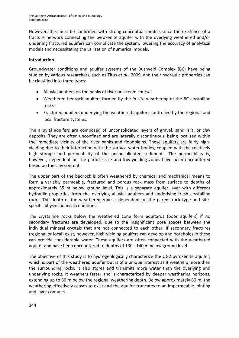
conceptual model of the aquifer, in relation to the underground works, is shown in Figure 1.
However, unsealed deep exploration boreholes intersecting the UG2 pyroxenite and
reaching underground mine workings, or mine roofbolts penetrating the weathered
pyroxenite aquifer from underneath, can result in significant groundwater inflows into the
underground workings. To reduce mine inflows, the underground mine should be situated
below the pyroxenite aquifer and mine infrastructure should not intercept or connect the
pyroxenite layer with the underground workings.
It is believed that the confined portion of the UG2 pyroxenite aquifer is recharged from the
updip direction from the weathered zone. However, if vertical or sub-vertical fractures exist
that connect the pyroxenite with the surface, the aquifer can be recharged directly by
infiltration.
The Southern African Institute of Mining and Metallurgy
Platinum 2012
146
Figure 1-A simplified hydrogeological conceptual model of the Bushveld Complex illustrating the
pyroxenite aquifer
Aquifer orientation
The orientation of the UG2 pyroxenite aquifer can easily be determined as it dips with the
Bushveld strata and the aquifer is confined along the pyroxenite unit. The aquifer geometry
in this study is investigated following diamond drilling, percussion drilling, and aquifer
testing.
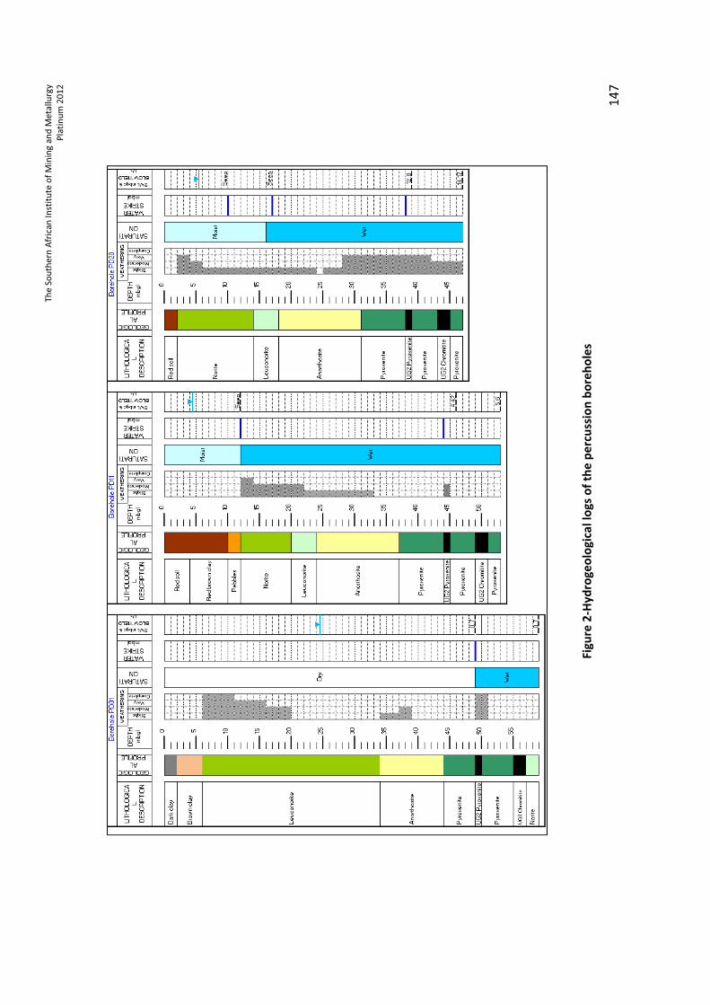
The positions of three of the percussion boreholes (PD01, PD11, and PD20) are illustrated in
Figure 1. All of the boreholes were drilled 2 m below the UG2 chromitite layer. Since the
geology is dipping to the north-east, PD01 is the deepest while PD20 is the shallowest.
Hydrogeological logs and depths of the three boreholes are given in Figure 2.
Hydraulic properties
The UG2 pyroxenite aquifer is responsible for most of the groundwater inflow into the
underground mines, and can be classified as the most important aquifer in the vicinity of the
mining zone. The hydraulic head in the aquifer follows the dip of the bedding plane (not the
topography) and the groundwater flows towards the north-east (opposite to the dip of the
ground surface), confirming the confinement of the groundwater within the pyroxenite unit.
Th
e S
ou
the
rn A
fric
an
In
stit
ute
of
Min
ing
an
d M
eta
llu
rgy
Pla
tin
um
20
12
14
7
Fig
ure
2-H
yd
rog
eo
log
ica
l lo
gs
of
the
pe
rcu
ssio
n b
ore
ho
les
The Southern African Institute of Mining and Metallurgy
Platinum 2012
148
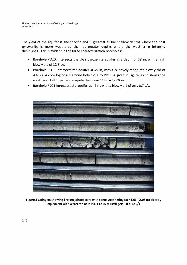
The yield of the aquifer is site-specific and is greatest at the shallow depths where the host
pyroxenite is more weathered than at greater depths where the weathering intensity
diminishes. This is evident in the three characterization boreholes:
• Borehole PD20, intersects the UG2 pyroxenite aquifer at a depth of 38 m, with a high
blow yield of 12.8 L/s
• Borehole PD11 intersects the aquifer at 45 m, with a relatively moderate blow yield of
4.4 L/s. A core log of a diamond hole close to PD11 is given in Figure 3 and shows the
weathered UG2 pyroxenite aquifer between 41.66 – 42.08 m
• Borehole PD01 intersects the aquifer at 49 m, with a blow yield of only 0.7 L/s.
Figure 3-Stringers showing broken jointed core with some weathering (at 41.66-42.08 m) directly
equivalent with water strike in PD11 at 45 m (stringers) of 4.42 L/s
The Southern African Institute of Mining and Metallurgy
Platinum 2012
149
The degree of weathering of the pyroxenite layer also decreases with depth, probably due to
the increasing stress of the overburden. This results in the decrease of the aquifer
transmissivity with depth:
• The transmissivity in the shallow part of the aquifer (around 40 m below surface) is
approximately 10 m2/d
• The transmissivity at a depth of 50 m is approximately 1 m2/d
• The transmissivity below the depth of approximately 80 m is zero.
Inflow predictions
At depths shallower than 30 – 35 m, there is a real risk of groundwater inflow into the workings
via naturally occurring open joints, fractures, and local pockets of deeper weathering as well as
along roofbolts.
No groundwater inflow into the mines is expected under natural conditions below
approximately 35 m. However, this can be compromised as a result of both surface and
underground mining-related activity, resulting in inflow into the mine workings:
• Surface drill holes, shafts, etc. penetrate the lower boundary of the aquifer (base of
stringers) through the aquitard and into the mine workings
• Long roofbolts used for roof support (along the hangingwall contact of the UG2L) can
also penetrate the lower boundary of the aquifer with resulting seepage into the mine
workings down the roof bolt. Long-term effects include significant corrosion of the
roofbolt with possible increasing groundwater inflow;
• Underground development with elevated roof construction above the elevation of the
UG2L hangingwall can reduce the thickness of the intervening pyroxenite aquitard,
causing leakage from the lower boundary of the aquifer
• The impact of blast-induced fractures in the hangingwall of the UG2 stopes may reduce
the effectiveness of the aquitard by increasing permeability of the pyroxenite, allowing
seepage from the lower boundary of the aquifer.
To estimate inflow rates into boreholes or shafts intersecting the UG2 aquifer, 2-dimentional
analytical equations can be applied, assuming no-flow boundaries on the hanging- and footwall
of the aquifer since the boundary is almost impermeable crystalline rocks.
The Southern African Institute of Mining and Metallurgy
Platinum 2012
150
Analytical models can then be applied to estimate the radial inflow into boreholes or shafts.
Thiem’s equation for confined aquifer is a preferred method for the steady-state flow
calculations in such aquifer geometry. The equation is given as:
� � 2�� �� � ��2.3log � �
���
where:
T = transmissivity of the aquifer (m2/d)
h and h1 = heads in the abstraction and observation boreholes, respectively
r and r1 = radius of the abstraction borehole and the distance to the
observation borehole
Before the application of analytical solutions, however, strong conceptual models of the site
must be developed, since the existence of fracture network connecting the pyroxenite aquifers
with the overlying weathered and/or underling fractured aquifers can complicate the system.
This can lower the accuracy of analytical models and necessitate the utilization of numerical
models.
Conclusions and recommendations
Hydrogeological studies conducted in the Critical Zone of the Bushveld Complex in the western
limb show that the UG2 pyroxenite is of particular interest and has unique aquifer properties. It
yields much of the groundwater inflow into some mines and can be classified as the most
important aquifer in the vicinity of the mining zone.
To considerably reduce mine inflow rates, underground mining and development should take
place below the pyroxenite aquifer, and mine infrastructure should not intercept or connect the
aquifer with the underground works.
The hydraulic properties of the UG2 pyroxenite aquifer are fairly well understood following a
diamond drilling, percussion drilling, and aquifer testing investigations. However, a better
understanding of the physiochemical conditions and the weathering characteristics of the UG2
pyroxenite would assist optimal planning and underground mining of shallow UG2 reserves and
allow improved mine groundwater management.
The Southern African Institute of Mining and Metallurgy
Platinum 2012
151
References
Titus, R., Witthüser, K., and Walters, B. 2009. Groundwater and mining in the Bushveld
Complex. Proceedings of the International Mine Water Conference, Pretoria, South Africa,
19-23 October 2009.Water Institute of Southern Africa and International Mine Water
Association.
The Author
Robel Gebrekristos, Unit Manger – Hydrogeology, Digby Wells Environmental
Robel Gebrekristos is a hydrogeologist with more than 10 years of experience, both as a
corporate consultant and a researcher. He achieved his Doctorate in Hydrogeology from the
Institute for Groundwater Studies, University of the Free State in 2007. Robel specialises in
groundwater modelling, environmental impact assessment, geochemical interpretation and
groundwater resource management.
Robel’s experience with groundwater modelling includes using finite difference (PMWIN and
VMOD) and finite element (FEFLOW) software packages, tailings seepage modelling (using
SEEP/W), water balance evaluations and database management. He is competent in VB.net
and C++ programming. Robel has written papers, documents and manuals on his field of
expertise.

The Southern African Institute of Mining and Metallurgy
Platinum 2012
152