Hydrogeo-Electric Characteristics of Upper River Shemankar
11
IOSR Journal of Applied Geology and Geophysics (IOSR-JAGG) e-ISSN: 2321–0990, p-ISSN: 2321–0982.Volume 1, Issue 5 (Nov. – Dec. 2013), PP 47-57 www.iosrjournals.org www.iosrjournals.org 47 | Page Hydrogeo-Electric Characteristics of Upper River Shemankar Basin, Jos Plateau: A Case Study of Jibam and Environs. * Longpia, C.B, ** Dakwo, P.D & *** Lar, U. A * Dept. of Mineral Resources Engineering, Plateau State Polytechnic Barkin Ladi. ** Lonpigrand Geotechnics Nig. Ltd. Jos. *** Dept. of Geology & Mining, University of Jos, Jos. Abstract: A detailed hydrogeo-electric investigation of Jibam Village and environs was carried out to determine the peculiar difficult hydrogeological disposition of the area which result in well and borehole failures. The area is underlain by Basement Complex rocks (migmatites, granite gneiss and pegmatites) and Newer basalts. A total of 70 vertical electrical sounding (VES) were carried out within the study area. The field data were interpreted using computer aided programe (Win Resists) and from the geo-electric parameters, 4-5 geoelectirc layers were identified which include- Topsoil from 0-3.8m, Weathered basement/basalt from 0.1- 21m, Basalt/fractured basalt from 0.1-20m, Sub-basalt alluvium from 20-30m and Fresh basement from 10.1- ∞m, and characterized by variable resistivity value range from 93-634 ohm/m, 23-152 ohm/m, 178-693 ohm/m, 28-70 ohm/m and 100-1296 ohm/m respectively. The interpreted geoelectric parameters from the VES model curves were used to produce geo-electric sections, isopach maps, bedrock relief/structural maps which aided in the development of the overall groundwater potential map of the area. This study revealed that basement depressions with moderate overburden and areas underlain by sub-basalt alluvium and/or fractured basalts are areas with low and medium-high groundwater potential respectively. Keywords: Hydrogeo-electric investigation, Basement Complex rocks, Basalts, VES model curves, River Shemankar and Jos Plateau. I. Introduction Jibam and environs, lies within the upper ridges of the River Shemankar (Fig. 1a) between latitudes 9.1389 N and 9.1979 N and longitudes 9.3211 E and 9.3361 E (Fig. 1b). The adjoining communities include Zong, Mhies, Kapil and Jing and it covers a total land area of about 21km 2 . The study area lies within the Gu volcanic provinces. This volcanic province consists of a series of six volcanic vents aligned in NE-SW direction along a hypothetical fissure through the earthcrust. It is part of the product of the uplift of the Jos Plateau that occurred shortly before the end of the Tertiary and was occupied by volcanism and denudation (Ajaegbu et’al, 1992). The study area sits within a valley filled with basalts flows and is characterized by undulating terrain with ridging; and is dissected by rivers/valleys to the northern extreme of the basin. The river and/ or valleys, have been filled by basalt flows and apparently modifying the pre-volcanic drainage network. Jibam and environs have a peculiar problem of high borehole and/ well failures as a result of shallow weathered basement overburden and where fractures are encountered, they are generally dry. Inhabitants of these c0mmunities source their water for domestic use mainly from the gorge river with its quality highly questionably, as a result of prevalence of water related diseases. It is this high failure rate that has prompted the need to determine the detailed hydrogeophysical characteristics/deposition of the area in order to capture the cause of the failures/and increase the boreholes drilling success within the environs.
Transcript of Hydrogeo-Electric Characteristics of Upper River Shemankar

IOSR Journal of Applied Geology and Geophysics (IOSR-JAGG)
e-ISSN: 2321–0990, p-ISSN: 2321–0982.Volume 1, Issue 5 (Nov. – Dec. 2013), PP 47-57 www.iosrjournals.org
www.iosrjournals.org 47 | Page
Hydrogeo-Electric Characteristics of Upper River Shemankar
Basin, Jos Plateau: A Case Study of Jibam and Environs.
* Longpia, C.B, ** Dakwo, P.D & *** Lar, U. A * Dept. of Mineral Resources Engineering, Plateau State Polytechnic Barkin Ladi.
** Lonpigrand Geotechnics Nig. Ltd. Jos. *** Dept. of Geology & Mining, University of Jos, Jos.
Abstract: A detailed hydrogeo-electric investigation of Jibam Village and environs was carried out to
determine the peculiar difficult hydrogeological disposition of the area which result in well and borehole
failures. The area is underlain by Basement Complex rocks (migmatites, granite gneiss and pegmatites) and
Newer basalts. A total of 70 vertical electrical sounding (VES) were carried out within the study area. The field
data were interpreted using computer aided programe (Win Resists) and from the geo-electric parameters, 4-5
geoelectirc layers were identified which include- Topsoil from 0-3.8m, Weathered basement/basalt from 0.1-
21m, Basalt/fractured basalt from 0.1-20m, Sub-basalt alluvium from 20-30m and Fresh basement from 10.1-
∞m, and characterized by variable resistivity value range from 93-634 ohm/m, 23-152 ohm/m, 178-693 ohm/m,
28-70 ohm/m and 100-1296 ohm/m respectively. The interpreted geoelectric parameters from the VES model
curves were used to produce geo-electric sections, isopach maps, bedrock relief/structural maps which aided in the development of the overall groundwater potential map of the area. This study revealed that basement
depressions with moderate overburden and areas underlain by sub-basalt alluvium and/or fractured basalts are
areas with low and medium-high groundwater potential respectively.
Keywords: Hydrogeo-electric investigation, Basement Complex rocks, Basalts, VES model curves, River
Shemankar and Jos Plateau.
I. Introduction Jibam and environs, lies within the upper ridges of the River Shemankar (Fig. 1a) between latitudes
9.1389 N and 9.1979 N and longitudes 9.3211 E and 9.3361 E (Fig. 1b). The adjoining communities include
Zong, Mhies, Kapil and Jing and it covers a total land area of about 21km2.
The study area lies within the Gu volcanic provinces. This volcanic province consists of a series of six
volcanic vents aligned in NE-SW direction along a hypothetical fissure through the earthcrust. It is part of the product of the uplift of the Jos Plateau that occurred shortly before the end of the Tertiary and was occupied by
volcanism and denudation (Ajaegbu et’al, 1992). The study area sits within a valley filled with basalts flows and
is characterized by undulating terrain with ridging; and is dissected by rivers/valleys to the northern extreme of
the basin. The river and/ or valleys, have been filled by basalt flows and apparently modifying the pre-volcanic
drainage network.
Jibam and environs have a peculiar problem of high borehole and/ well failures as a result of shallow
weathered basement overburden and where fractures are encountered, they are generally dry. Inhabitants of
these c0mmunities source their water for domestic use mainly from the gorge river with its quality highly
questionably, as a result of prevalence of water related diseases. It is this high failure rate that has prompted the
need to determine the detailed hydrogeophysical characteristics/deposition of the area in order to capture the
cause of the failures/and increase the boreholes drilling success within the environs.

Hydrogeo-Electric Characteristics Of Upper River Shemankar Basin, Jos Plateau: A Case Study Of
www.iosrjournals.org 48 | Page
Fig. 1a: Map of Upper River Shemankar Basin.
Fig. 1b: Location Map of the Study area.

Hydrogeo-Electric Characteristics Of Upper River Shemankar Basin, Jos Plateau: A Case Study Of
www.iosrjournals.org 49 | Page
GEOLOGY AND HYDROGEOLOGY
Jibam village and environs is underlain by two major rock types, Basement Complex
(Migmatites/Granites Gneiss) and Newer Basalt (Fig2). The stratigraphic succession within the study area is as summarized in Table 1.
Table 1: Geologic/Stratigraphic Succession around Jibam and Environs. Rock Type/Formation Age
3 Newer Basalt Quaternary
2 Sub-Basalt alluvium Paleogene-Neogene
1 Migmatites/Granite-Gneiss Pre-Cambrian (Archean-Proterozoic)
The Migmatites/Granite-Gneiss rocks in the study area comprises of schists, gneises, migmatites,
marbles and quartzites.
The Newer basalt over lies the Basement Complex rocks. The basalt are formed from the lava which
erupted from the vents of the volcanoes within the Gu line filling narrow and wide valleys flowing eastwards and southwards, coalescing to form an extensive sheet covering the Shemankar plains. Where there is
accumulation of pre-volcanic sediments within the valleys, the laval flow buries the alluvium and form a sub-
basalt layer which is more of an “envelope” of sediments between the basalt and the basement1 (Plate 1). The
alluvium, if consists essentially of gravels and sands, are very good aquifers (Offodile, 2003). The sub-basalt is
usually traceable to ancient rivers or buried river/valley channels (Pre-volcanic).
Fig. 2: Geological Map of the study area showing the Geoelectric Sounding locations.
Three types of aquifers namely; fractured crystalline, soft or weathered and volcanic aquifers have been
identified around Jibam and its environs. This is in good agreement with the three aquifer types reported by
Ajaegbu et’al, 1992 on the Jos Plateau.
Around the study area, a successful borehole drilled encountered a sub-basalt alluvium and with a yield
of 1.1 l/s, (Fatigen Drilling, 2010). There are several spring that issues at near base of the River Shemankar,
north of Jibam. The springs issues within the sub-basalt lithological section and are characteristically perennial
(Plate 2).

Hydrogeo-Electric Characteristics Of Upper River Shemankar Basin, Jos Plateau: A Case Study Of
www.iosrjournals.org 50 | Page
Plate 1: Sub-basalt Alluvium (Sands, Clays and Gravels intermix with lava) exposed within the River
Shemankar.
Plate 2: Volcanic Spring issuing out from sub-basalt/fractured basalt within the River Shemankar.
II. Materials And Method. An integrati0n of geological, hydrogeological and geophysical study was applied in this study.
The geological aspect involved surface mapping to determine the rock types and structural disposition
especially geological structures relevant to groundwater occurrence (fractures in the form of faults, shear zones,
etc.).
The hydrogeological investigations consists of generating data from existing hydraulic structures (wells and boreholes) to ascertain the static water level vis a vis the lithologic logs within the study area. The static
water level were carried out using water level indicators (measuring tape) prior to abstraction through pumping
in wells/boreholes. The measuring tape was lowered into the well until it reaches the water table; the static water
level was then recorded from the measuring tape. Subsequently, the location coordinates and topographic
elevations of the wells and boreholes within the study area were determined using GARMIN Etrex 12 channel
portable Global Positioning System (GPS) unit.
Finally, electrical resistivity measurements employing the schlumberger array was carried out using
ABEM Terrameter SAS 1000 series. A total of 70 geo-electric resistivity soundings (P1 to P70) were carried out
in the study area. The current electrode spacing (AB/2) was varied from 1.5 to 215m and 500m.
The geophysical field data collected was interpreted using resistivity sounding interpretation software,
Win Resist Version 1.0 (Vander Velpen, 1988, 2004). It is based on smoothness constrained optimization to
define the geo-electric parameters as obtained from each geo-electric sounding data.
III. Result And Discussion Type Curves
The interpretation of the VES data obtained for the research revealed searth models with geoelectric
layers/lithologic units ranging from two (2) to six (6). The type curves representing geoelectric layers and their
respective frequencies are shown in Table 2.

Hydrogeo-Electric Characteristics Of Upper River Shemankar Basin, Jos Plateau: A Case Study Of
www.iosrjournals.org 51 | Page
Table 2: VES Type Curves and Frequency.
Type
curve
VES Points Frequency
Percentage
Frequency
H P44,P23,P15 3 4
A P31,P60 2 3
HKA P18,P36,P37,P48,P49,P63,P64,P67,P68 9 13
KH P34 1 1
QH P13,P24,P38,P39,P43 5 7
QKA P4,P8,P26,P27,P35,P42,P46,P47 8 11
HA P1,P2,P5,P6,P7,P9,P10,P11,P12,P14,P16,P19,P20,P21,P22,P25,P
28,P29,P30,P40,P45,P40,P45,P50,P51,
P52,P56,P58,P59,P61,P62,P65,P66,P70
33 47
KA P3, P17,P32,P33,P53,P54,P55,P57 8 11
K P41 1 1
The type curves were interpreted in terms of their hydrogeologic significance to serve as basis for the
definition of aquifer architecture within the study area, since each of the type curves represents certain geometry
of the geoelectric layers in the subsurface. Fig. 3 shows typical computer modeled VES curves in the study
area.
Fig. 3a: VES within the sub-basalt environs.
Fig.3b
Fig. 3c
Fig. 3: Typical VES Curves from the Study Area.
Geo-electrical parameters of the geo-electric sequence.

Hydrogeo-Electric Characteristics Of Upper River Shemankar Basin, Jos Plateau: A Case Study Of
www.iosrjournals.org 52 | Page
From the geo-electric resistivity sounding data five (5) major lithologic units can be delineated in the
study area – Topsoil, Weathered zone, Basalt/fractured basalt zone, Sub-basalt alluvium and the bedrock.
Correlative 2-D geo-electric sections (Figs. 4, 5, 6, 7 and 8) were taken in SE-NW, SW-NE and N-S across the study area with the aim of gaining an insight into the subsurface lithological disposition in the area.
Fig. 4: Geo-electric Section along NW-SW Direction (P62-P65 axis).
The topsoil layer is from 0.9-3.8m and characterized by resistivity value range from 93 to 634 ohm-m.
The low resistivity in the range of ≤ 100 ohm-m are characteristic of clay/clayey sands while those with
resistivity ≥ 100 ohm-m are characteristic of lateritic clay/lateritic sandy clay/compact sand.
The thickness of the weathered layer varies from 0.1-21m and characterized by low resistivity range of
23-152 ohm-m probably as a result of water saturation. This agrees with the assertion that significant saturation may be induced by reduction in resistivity (Omosuyi et’al, 2003).
Fig. 5: Geo-electric Section along SE-NW Direction (P34-P39 axis).
The Basalt/fractured basalt thickness layer range from 0.1-20m and it is characterized by high
resistivity value range of 178-693 ohm-m indicating a fresh rock which is apparantly unweathered.
Geo-electric sections across P34-P39, P46-P35-P63, P53-P15-P57 and P62-P65 in SE-NW, SW-NE,
NW-SE and NW-SW directions respectively (Fig. 4, 5, 6, and 7) correlates with borehole lithologic log (Fig. 9
and Fig 10) drilled on P15 and P37 respectively, revealed sub-basalt alluvium in the narrow and elongate
stretched of the basalt filled valleys. The sub-basalt is characterized by resistivity values of 28 to 70 0hm-m, and
with thickness of about 20-30m. This low resistivity can only be explained by the saturation of the aquifer.
Perennial springs issues in the vicinity of P35 as a result of incision by present river course and exposes the sub-
basalt and /or fractures which the spring issues out from.

Hydrogeo-Electric Characteristics Of Upper River Shemankar Basin, Jos Plateau: A Case Study Of
www.iosrjournals.org 53 | Page
Fig. 6: Geo-electric Section along SW-NE Direction (P46-P63 axis).
The geo-electric section across P12-P4-P13 in N-S direction (Fig. 8) revealed fractures encountered at
P4 with resistivity often < 200 ohm-m in the study area. Fractures when filled with water are aquiferous and
these fractured aquifers can compliment weathered overburden aquifer overlying the bedrock.
Fig. 7: Geo-electric Section along NW-SE Direction (P53-P15-P57 axis).
Fig. 8: Geo-electric Section along N-S Direction (P12-P4-P13 axis).
Topsoil
Weathered Basalt
F
420
Fracture
Resistivity in ohm/m
VES Point
Topsoil
Weathered Basalt
F
420
Fracture
Resistivity in ohm/m
VES Point

Hydrogeo-Electric Characteristics Of Upper River Shemankar Basin, Jos Plateau: A Case Study Of
www.iosrjournals.org 54 | Page
Inferred Pre-volcanic River
In figures 4, 5, 6 and 7 reveals variable thicknesses of inferred buried alluvial deposits where
encountered between 9-35m depth are presented. An extra-polation of these sections appears to reveal a pre-
volcanic river/valley which rises at the foot of a mountain north of the study area and flows for a short distance
westwards, then southwards (Fig. 11). North of the study area, a post-volcanic gorge river hosting the upper reaches of Shemankar River exposed a section of the pre-volcanic river/valley alluvium (Fig. 6). The sub-basalt
layer/fractured basement is characterized by perennial springs oozing from it as indicated along P34-P37 geo-
electric section. The pre-volcanic river/valley alluvium is also exposed in the river section at P46 and appears to
be a continuation of the river as inferred at P35 (Fig. 6).
Based on the geo-electric and river section lithology at P45-P49, the present river appears to have
changed course over time which is different from the pre-volcanic period.
10
15
30
35
10
30

Hydrogeo-Electric Characteristics Of Upper River Shemankar Basin, Jos Plateau: A Case Study Of
www.iosrjournals.org 55 | Page
Fig. 11: Infered Pre-volcanic River.
Isopach Map of Weathered Overburden The depth to basement established from the interpretation of VES sounding interpretation for each
station occupied were plotted and contoured as isopach map (Fig. 11) using Surfer 9 GIS programme. The
overburden thickness in the area varies from<10 to 25m.
Fig. 12: Isopach Map of the Overburden.
The areas in the NE, SW, NW, SE and central parts of the study area has a relatively thin overburden
(<1 to 10m), occupying approximately 85% of the study area. Areas with overburden thickness of >10 to 25m
occupies approximately 15% of the study area.

Hydrogeo-Electric Characteristics Of Upper River Shemankar Basin, Jos Plateau: A Case Study Of
www.iosrjournals.org 56 | Page
Although zones of thick weathered overburden in basement terrain have been identified as areas of
high groundwater potential (Okhue and Olorunfemi, 1991), the presumably thick overburden is not weathered
material, but thick pegmatites rocks of the basement complex and is apparently dry.
Basement Relief/Structural Map. A bedrock relief map is a reflection of the bedrock topography and its structural deposition is presented
in Fig. 13. From this map, topographic ridges and depressions are identified. The ridges are marked by areas
with thin overburden where as depression are marked by areas of thick overburden. The depressions are
identified along the axis P36-P65, P50-P51-P52, P15-P16, P24-P25, and P6-P7 denoted by the symbols D1, D3, D5, D6 and D7 (Fig 13)
Fig. 13: Relief/Structural Map of the Bedrock.
The Inferred Pre-volcanic river/valley which rises from the basement hill north of the study area flows
beneath depressions D1, D2 and D5. Along the river course, springs issues out at intersect of basement/alluvial
contact and appears to be main contributor to the base flow of the River Shemankar.
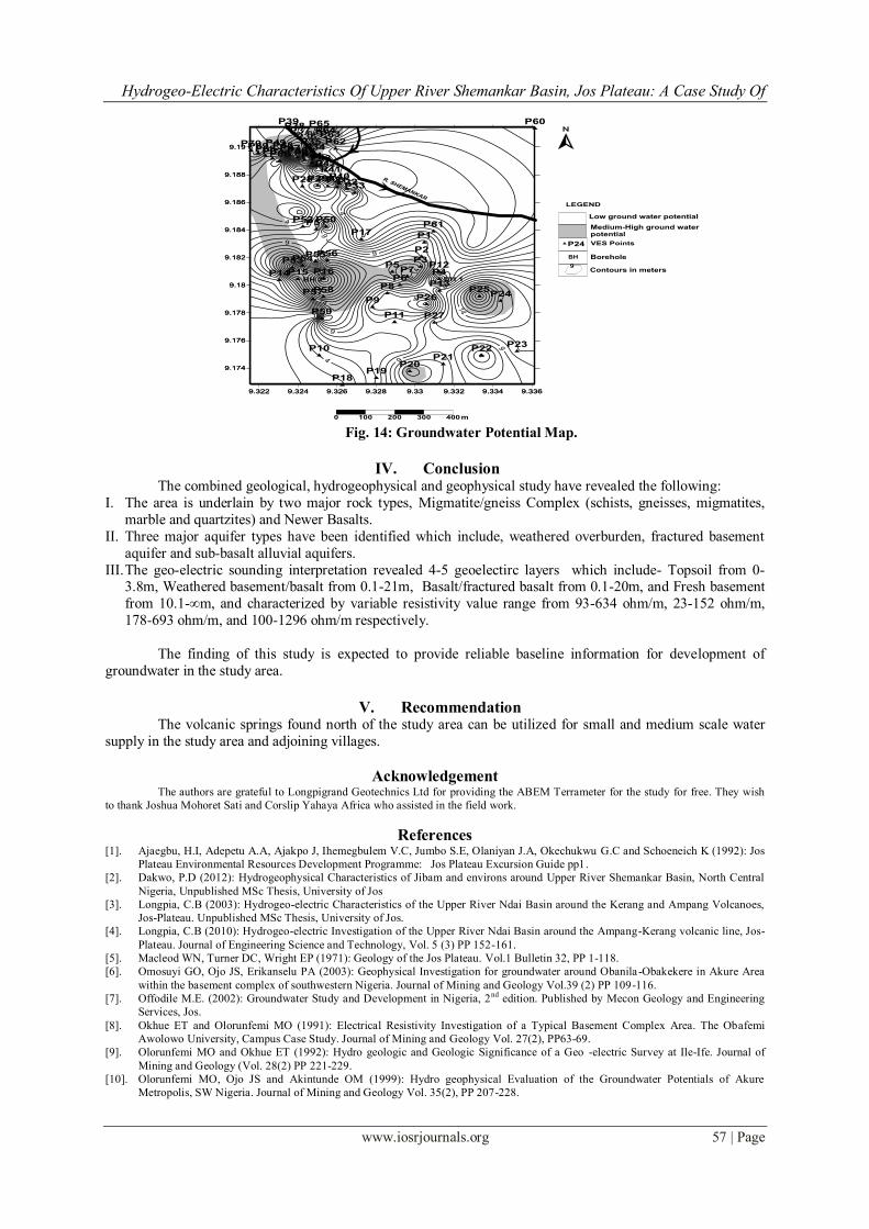
Groundwater Potential Evaluation From this study, the groundwater potential characterization is developed based on the geo-electric
sections, isopach and basement relief maps prepared from geo-electric parameters as interpreted from the VES
model curves (aided by borehole lithological information). According to this map (Fig. 14), there are basically
two broad areas of groundwater yield, namely area of medium to high groundwater potential and areas of low
groundwater potential. As fig. 14 illustrates, most of the VES locations estimated to have medium to high groundwater potential lie within the groundwater converging zone and the inferred pre-volcanic river stretching
from the north-western to the central parts of the study area. In the groundwater radiating zone by contrast, there
is equal possibilities of encountering low and medium groundwater yield locations.
Hydrogeo-Electric Characteristics Of Upper River Shemankar Basin, Jos Plateau: A Case Study Of
www.iosrjournals.org 57 | Page
Fig. 14: Groundwater Potential Map.
IV. Conclusion The combined geological, hydrogeophysical and geophysical study have revealed the following:
I. The area is underlain by two major rock types, Migmatite/gneiss Complex (schists, gneisses, migmatites,
marble and quartzites) and Newer Basalts.
II. Three major aquifer types have been identified which include, weathered overburden, fractured basement
aquifer and sub-basalt alluvial aquifers.
III. The geo-electric sounding interpretation revealed 4-5 geoelectirc layers which include- Topsoil from 0-3.8m, Weathered basement/basalt from 0.1-21m, Basalt/fractured basalt from 0.1-20m, and Fresh basement
from 10.1-∞m, and characterized by variable resistivity value range from 93-634 ohm/m, 23-152 ohm/m,
178-693 ohm/m, and 100-1296 ohm/m respectively.
The finding of this study is expected to provide reliable baseline information for development of
groundwater in the study area.
V. Recommendation The volcanic springs found north of the study area can be utilized for small and medium scale water
supply in the study area and adjoining villages.
Acknowledgement The authors are grateful to Longpigrand Geotechnics Ltd for providing the ABEM Terrameter for the study for free. They wish
to thank Joshua Mohoret Sati and Corslip Yahaya Africa who assisted in the field work.
References [1]. Ajaegbu, H.I, Adepetu A.A, Ajakpo J, Ihemegbulem V.C, Jumbo S.E, Olaniyan J.A, Okechukwu G.C and Schoeneich K (1992): Jos
Plateau Environmental Resources Development Programme: Jos Plateau Excursion Guide pp1.
[2]. Dakwo, P.D (2012): Hydrogeophysical Characteristics of Jibam and environs around Upper River Shemankar Basin, North Central
Nigeria, Unpublished MSc Thesis, University of Jos
[3]. Longpia, C.B (2003): Hydrogeo-electric Characteristics of the Upper River Ndai Basin around the Kerang and Ampang Volcanoes,
Jos-Plateau. Unpublished MSc Thesis, University of Jos.
[4]. Longpia, C.B (2010): Hydrogeo-electric Investigation of the Upper River Ndai Basin around the Ampang-Kerang volcanic line, Jos-
Plateau. Journal of Engineering Science and Technology, Vol. 5 (3) PP 152-161.
[5]. Macleod WN, Turner DC, Wright EP (1971): Geology of the Jos Plateau. Vol.1 Bulletin 32, PP 1-118.
[6]. Omosuyi GO, Ojo JS, Erikanselu PA (2003): Geophysical Investigation for groundwater around Obanila -Obakekere in Akure Area
within the basement complex of southwestern Nigeria. Journal of Mining and Geology Vol.39 (2) PP 109-116.
[7]. Offodile M.E. (2002): Groundwater Study and Development in Nigeria, 2nd
edition. Published by Mecon Geology and Engineering
Services, Jos.
[8]. Okhue ET and Olorunfemi MO (1991): Electrical Resistivity Investigation of a Typical Basement Complex Area. The Obafemi
Awolowo University, Campus Case Study. Journal of Mining and Geology Vol. 27(2), PP63-69.
[9]. Olorunfemi MO and Okhue ET (1992): Hydro geologic and Geologic Significance of a Geo -electric Survey at Ile-Ife. Journal of
Mining and Geology (Vol. 28(2) PP 221-229.
[10]. Olorunfemi MO, Ojo JS and Akintunde OM (1999): Hydro geophysical Evaluation of the Groundwater Potentials of Akure
Metropolis, SW Nigeria. Journal of Mining and Geology Vol. 35(2), PP 207-228.