Huron City Schools
32
Huron City Schools SAFE ROUTES TO SCHOOL TRAVEL PLAN December 2015 OHIO SAFE ROUTES TO SCHOOL SCHOOL TRAVEL PLAN
Transcript of Huron City Schools
Huron City Schools SAFE ROUTES TO SCHOOL TRAVEL PLAN
December 2015
OHIO SAFE ROUTES TO SCHOOLSCHOOL TRAVEL PLAN

| Ohio’s Safe Routes to School Travel Plan Tem
plate | w
ww.dot.state.oh.us/saferoutes
2
1A. Identify Target Schools:
School District School Name School Address Grades served
Huron City School District Shawnee Elementary school 710 Cleveland Road Suite A Huron, OH 44839
PK‐2
Huron City School District Woodlands Elementary School 1810 Maple Avenue Huron, OH 44839 3‐6
Huron City School District McCormick Jr High School 325 Ohio Street Huron, OH 44839 7‐8
Shawnee Elementary School’s Students 2013‐2014Average Daily
Student Enrollment Black, non‐
Hispanic
American
Indian or
Alaska Native
Asian or
Pacific Islander
Hispanic Multi‐Racial
White, non‐
Hispanic
Economically Disadvantaged
Limited English
Proficient
Students with
Disabilities
Migrant
261
4.6% 9.8% 90.2% 43.8% 13.0%
Woodlands Elementary School’s Students 2013‐2014Average Daily
Student Enrollment Black, non‐
Hispanic
American
Indian or
Alaska Native
Asian or
Pacific Islander
Hispanic Multi‐Racial
White, non‐
Hispanic
Economically Disadvantaged
Limited English
Proficient
Students with
Disabilities
Migrant
419
4.5% 2.9% 89.1% 33.5% 9.9%
McCormick Jr. High School’s Students 2013‐2014Average Daily
Student Enrollment Black, non‐
Hispanic
American
Indian or
Alaska Native
Asian or
Pacific Islander
Hispanic Multi‐Racial
White, non‐
Hispanic
Economically Disadvantaged
Limited English
Proficient
Students with
Disabilities
Migrant
240
4.2% 92% 30% 9.1%
Note: All enrollment information above provided from the Ohio Department of Education (ODE) website at www.reportcard.ohio.gov
SECTION 1: OUR SCHOOLS
| Ohio’s Safe Routes to School Travel Plan Tem
plate | w
ww.dot.state.oh.us/saferoutes
3
1B. Community Stakeholders and the Safe Routes to School Team:
School Representatives:
Name Email address 5 E Role:
Dennis Muratori dmuratori@huron‐city.k12.oh.us Education
Chad Carter [email protected] Education/Evaluation
Local Government Representatives:
Name Email address 5 E Role:
Brad Hartung [email protected] Encouragement
Andrew White [email protected] Evaluation
Doug Green [email protected] Engineering
Carrie Whitaker [email protected] Engineering
Public Safety Representatives:
Name Email address 5 E Role:
Chief Robert Lippert [email protected] Enforcement
1C. The lead contact for our Plan is:
Name: Andrew White, City Manager
Affiliation: City of Huron, Ohio
Phone Number: 419‐433‐5000
Email address: [email protected]
Mailing address: 417 Main Street, Huron, OH 44839
Our SRTS Vision: Successful SRTS programs benefit from the school and community working together toward a common vision. Vision statements can be a single statement, a list of goals or a short paragraph. There is no correct or incorrect vision statement. In 100 words or less, explain your team’s vision for your SRTS program in the space below.
SECTION 2: OUR SRTS VISION
It is the vision of the Huron Safe Routes to Schools Steering Committee to develop a school
travel plan that will not only be utilized to encourage children grades K‐8 to participate in
walking and bicycling but also to provide them with safer routes when traveling to and from
school. Additionally, integrating a safe routes to school program will not only positively
impact students and their parents, but provide increased safety and health benefits for all
those that live in and visit the City of Huron.
| Ohio’s Safe Routes to School Travel Plan Tem
plate | w
ww.dot.state.oh.us/saferoutes
4
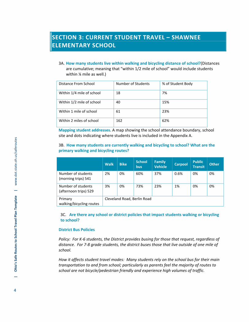
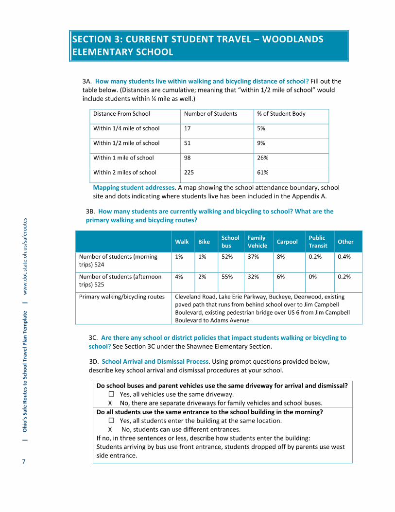
3A. How many students live within walking and bicycling distance of school?(Distances are cumulative; meaning that “within 1/2 mile of school” would include students within ¼ mile as well.)
Distance From School Number of Students % of Student Body
Within 1/4 mile of school 18 7%
Within 1/2 mile of school 40 15%
Within 1 mile of school 61 23%
Within 2 miles of school 162 62%
Mapping student addresses. A map showing the school attendance boundary, school site and dots indicating where students live is included in the Appendix A.
3B. How many students are currently walking and bicycling to school? What are the primary walking and bicycling routes?
Walk Bike School bus
Family Vehicle
Carpool Public Transit
Other
Number of students (morning trips) 541
2% 0% 60% 37% 0.6% 0% 0%
Number of students (afternoon trips) 529
3% 0% 73% 23% 1% 0% 0%
Primary walking/bicycling routes
Cleveland Road, Berlin Road
3C. Are there any school or district policies that impact students walking or bicycling to school?
District Bus Policies
Policy: For K‐6 students, the District provides busing for those that request, regardless of distance. For 7‐8 grade students, the district buses those that live outside of one mile of school.
How it affects student travel modes: Many students rely on the school bus for their main transportation to and from school; particularly as parents feel the majority of routes to school are not bicycle/pedestrian friendly and experience high volumes of traffic.
SECTION 3: CURRENT STUDENT TRAVEL – SHAWNEE ELEMENTARY SCHOOL

| Ohio’s Safe Routes to School Travel Plan Tem
plate | w
ww.dot.state.oh.us/saferoutes
5
School Travel Policies
Policy: Bicycling/Walker policies? No specific bicycling or walking policies exist.
How it affects student travel modes (3‐5 sentences): Since the City installed a paved path from behind Woodlands Elementary over to Jim Campbell Boulevard, they have seen an increase in the number of students biking to school. However, no specific bicycling or walking policy currently exists.
3D. School Arrival and Dismissal Process. Using prompt questions provided below, describe key school arrival and dismissal procedures at your school.
Do school buses and parent vehicles use the same driveway for arrival and dismissal? Yes, all vehicles use the same driveway. X No, there are separate driveways for family vehicles and school buses.
Do all students use the same entrance to the school building in the morning? Yes, all students enter the building at the same location. X No, students can use different entrances.
If no, in three sentences or less, describe how students enter the building: Students being dropped off by private vehicle use the side entrance, bus riders use the front entrance and bikers/walkers are to use the east entrance.
Are all students released at the same time during dismissal? X Yes, all students are released at the same time. No, we use a staggered release process (walkers are released first, bus riders second, etc.).
Is school staff involved in either arrival or dismissal? X Yes, we have school staff help students enter and exit the campus safely. No, school staff is not involved in either arrival or dismissal.
If yes, in two sentences or less, describe how school staff are involved in school arrival and dismissal: Staff assists with the bus riders, walkers, and students being picked up by private vehicles.
Are there any adult crossing guards located along student walking routes? Yes, we have at least one adult crossing guard that helps students on their
walking routes. X No, we do not have any adult crossing guards serving our school.
Are there police officers that help with arrival or dismissal procedures at this school? X Yes, we have at least one police officer helping direct traffic around our school. No we do not have police officers who help direct traffic around the school. There is one school resource officer responsible for all Huron schools and assists when available.
Are students involved in any arrival or dismissal process (i.e. student safety patrol)? Yes, we have a student safety patrol. X No, we do not have a student safety patrol.
| Ohio’s Safe Routes to School Travel Plan Tem
plate | w
ww.dot.state.oh.us/saferoutes
6
Amount and speed of traffic along route combined with lack of
sidewalks/pathways are main traffic safety concerns at Shawnee
Elementary.
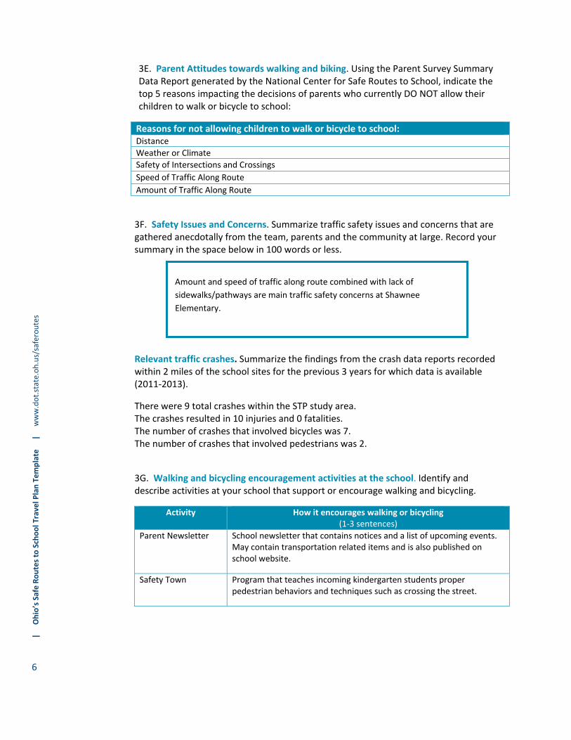
3E. Parent Attitudes towards walking and biking. Using the Parent Survey Summary Data Report generated by the National Center for Safe Routes to School, indicate the top 5 reasons impacting the decisions of parents who currently DO NOT allow their children to walk or bicycle to school:
Reasons for not allowing children to walk or bicycle to school: Distance
Weather or Climate
Safety of Intersections and Crossings
Speed of Traffic Along Route
Amount of Traffic Along Route
3F. Safety Issues and Concerns. Summarize traffic safety issues and concerns that are gathered anecdotally from the team, parents and the community at large. Record your summary in the space below in 100 words or less.
Relevant traffic crashes. Summarize the findings from the crash data reports recorded within 2 miles of the school sites for the previous 3 years for which data is available (2011‐2013).
There were 9 total crashes within the STP study area. The crashes resulted in 10 injuries and 0 fatalities. The number of crashes that involved bicycles was 7. The number of crashes that involved pedestrians was 2.
3G. Walking and bicycling encouragement activities at the school. Identify and describe activities at your school that support or encourage walking and bicycling.
Activity How it encourages walking or bicycling (1‐3 sentences)
Parent Newsletter School newsletter that contains notices and a list of upcoming events. May contain transportation related items and is also published on school website.
Safety Town Program that teaches incoming kindergarten students proper pedestrian behaviors and techniques such as crossing the street.
| Ohio’s Safe Routes to School Travel Plan Tem
plate | w
ww.dot.state.oh.us/saferoutes
7
3A. How many students live within walking and bicycling distance of school? Fill out the table below. (Distances are cumulative; meaning that “within 1/2 mile of school” would include students within ¼ mile as well.)
Distance From School Number of Students % of Student Body
Within 1/4 mile of school 17 5%
Within 1/2 mile of school 51 9%
Within 1 mile of school 98 26%
Within 2 miles of school 225 61%
Mapping student addresses. A map showing the school attendance boundary, school site and dots indicating where students live has been included in the Appendix A.
3B. How many students are currently walking and bicycling to school? What are the primary walking and bicycling routes?
Walk Bike School bus
Family Vehicle
Carpool Public Transit
Other
Number of students (morning trips) 524
1% 1% 52% 37% 8% 0.2% 0.4%
Number of students (afternoon trips) 525
4% 2% 55% 32% 6% 0% 0.2%
Primary walking/bicycling routes Cleveland Road, Lake Erie Parkway, Buckeye, Deerwood, existing paved path that runs from behind school over to Jim Campbell Boulevard, existing pedestrian bridge over US 6 from Jim Campbell Boulevard to Adams Avenue
3C. Are there any school or district policies that impact students walking or bicycling to school? See Section 3C under the Shawnee Elementary Section.
3D. School Arrival and Dismissal Process. Using prompt questions provided below, describe key school arrival and dismissal procedures at your school.
Do school buses and parent vehicles use the same driveway for arrival and dismissal? Yes, all vehicles use the same driveway. X No, there are separate driveways for family vehicles and school buses.
Do all students use the same entrance to the school building in the morning? Yes, all students enter the building at the same location. X No, students can use different entrances.
If no, in three sentences or less, describe how students enter the building: Students arriving by bus use front entrance, students dropped off by parents use west side entrance.
SECTION 3: CURRENT STUDENT TRAVEL – WOODLANDS ELEMENTARY SCHOOL

| Ohio’s Safe Routes to School Travel Plan Tem
plate | w
ww.dot.state.oh.us/saferoutes
8
Amount and speed of traffic along with lack of sidewalks/pathways are
main traffic safety issues at Woodlands Intermediate. Followed by safety
of intersections and crossings. Also, some parents surveyed noted they
would like to see the existing bike path behind the school be lighted and
supervised by adult/police if possible.
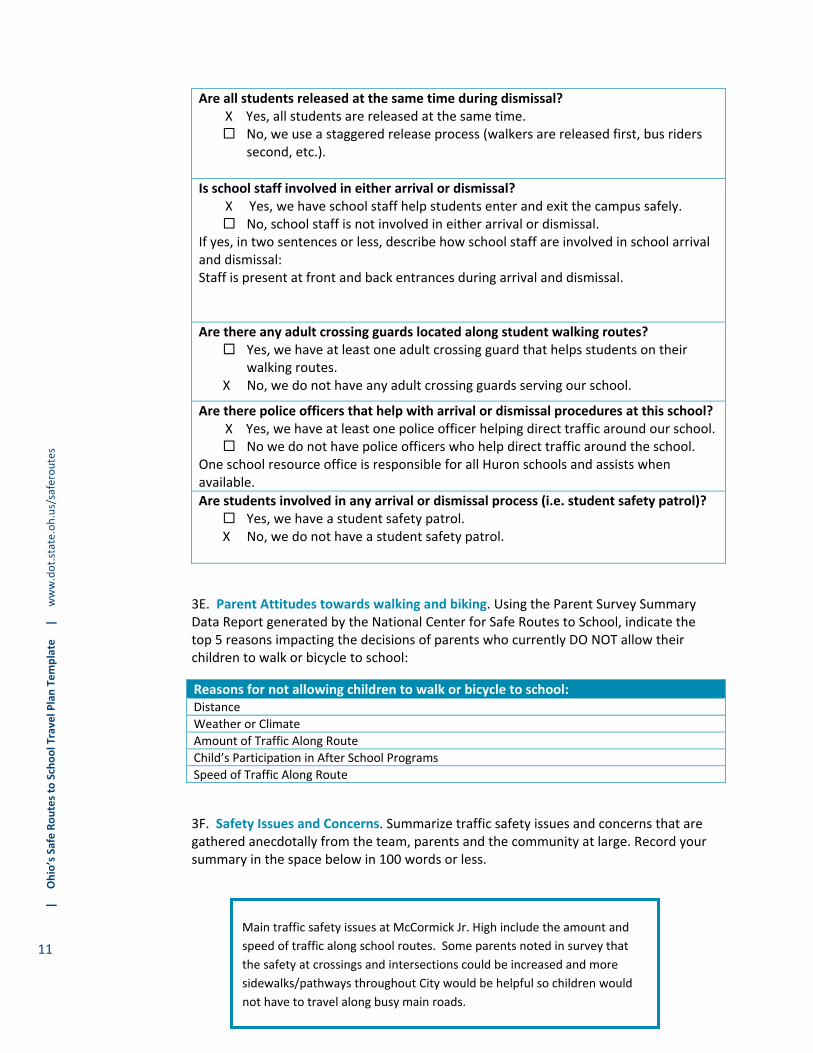
Are all students released at the same time during dismissal? X Yes, all students are released at the same time. No, we use a staggered release process (walkers are released first, bus riders
second, etc.).
Is school staff involved in either arrival or dismissal? X Yes, we have school staff help students enter and exit the campus safely. No, school staff is not involved in either arrival or dismissal.
If yes, in two sentences or less, describe how school staff are involved in school arrival and dismissal: Staff present at front and side entrances to assist with arrival and dismissal procedures.
Are there any adult crossing guards located along student walking routes? Yes, we have at least one adult crossing guard that helps students on their
walking routes. X No, we do not have any adult crossing guards serving our school.
Are there police officers that help with arrival or dismissal procedures at this school? X Yes, we have at least one police officer helping direct traffic around our school.
No we do not have police officers who help direct traffic around the school. There is one school resource officer responsible for all Huron schools and assists when available.
Are students involved in any arrival or dismissal process (i.e. student safety patrol)? Yes, we have a student safety patrol. X No, we do not have a student safety patrol.
3E. Parent Attitudes towards walking and biking. Using the Parent Survey Summary Data Report generated by the National Center for Safe Routes to School, indicate the top 5 reasons impacting the decisions of parents who currently DO NOT allow their children to walk or bicycle to school:
Reasons for not allowing children to walk or bicycle to school: Distance
Amount of Traffic Along Route
Speed of Traffic Along Route
Sidewalks or Pathways
Weather or Climate & Safety of Intersections and Crossings (tie)
3F. Safety Issues and Concerns. Summarize traffic safety issues and concerns that are gathered anecdotally from the team, parents and the community at large. Record your summary in the space below in 100 words or less.
| Ohio’s Safe Routes to School Travel Plan Tem
plate | w
ww.dot.state.oh.us/saferoutes
9
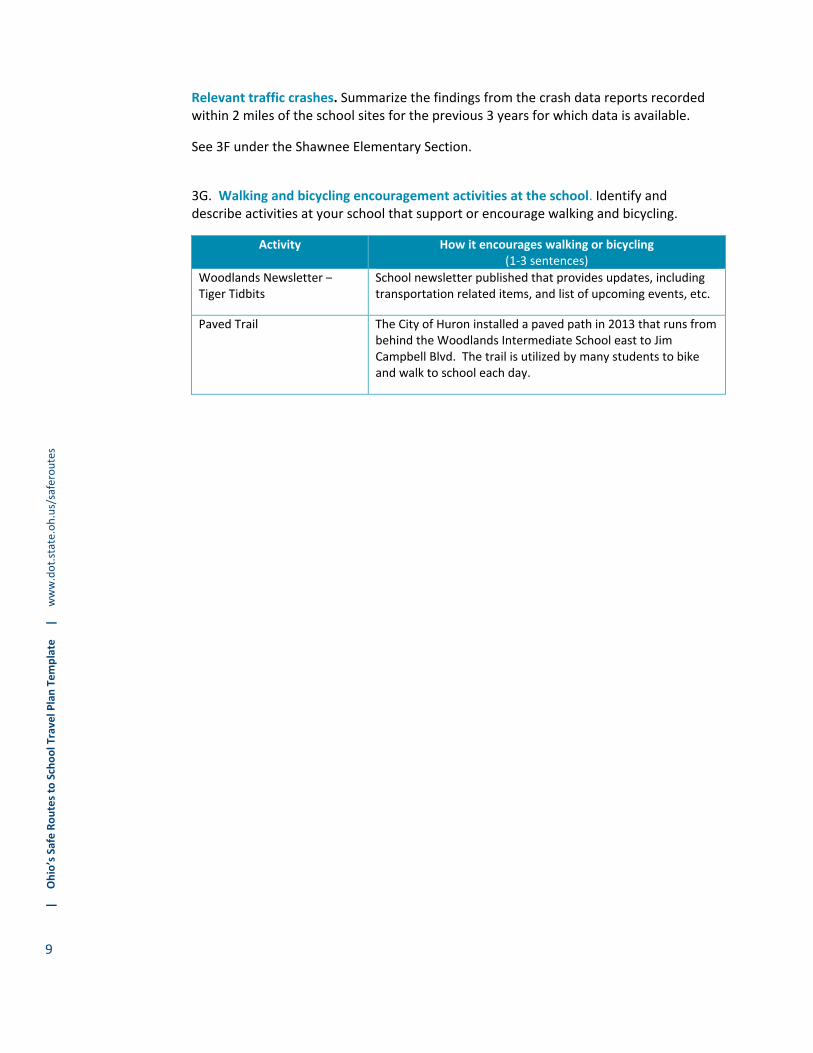
Relevant traffic crashes. Summarize the findings from the crash data reports recorded within 2 miles of the school sites for the previous 3 years for which data is available.
See 3F under the Shawnee Elementary Section.
3G. Walking and bicycling encouragement activities at the school. Identify and describe activities at your school that support or encourage walking and bicycling.
Activity How it encourages walking or bicycling (1‐3 sentences)
Woodlands Newsletter –Tiger Tidbits
School newsletter published that provides updates, including transportation related items, and list of upcoming events, etc.
Paved Trail The City of Huron installed a paved path in 2013 that runs from behind the Woodlands Intermediate School east to Jim Campbell Blvd. The trail is utilized by many students to bike and walk to school each day.

| Ohio’s Safe Routes to School Travel Plan Tem
plate | w
ww.dot.state.oh.us/saferoutes
10
3A. How many students live within walking and bicycling distance of school? Fill out the table below. (Distances are cumulative; meaning that “within 1/2 mile of school” would include students within ¼ mile as well.)
Distance From School Number of Students % of Student Body
Within 1/4 mile of school 26 11%
Within 1/2 mile of school 42 18%
Within 1 mile of school 87 37%
Within 2 miles of school 185 78%
Mapping student addresses. A map showing the school attendance boundary, school site and dots indicating where students live has been included in the Appendix A.
3B. How many students are currently walking and bicycling to school? What are the primary walking and bicycling routes?
Walk Bike School bus
Family Vehicle
Carpool Public Transit
Other
Number of students (morning trips) 356
7% 3% 32% 51% 8% 0% 0%
Number of students (afternoon trips) 342
18% 3% 42% 29% 8% 0% 0%
Primary walking/bicycling routes
Ohio Street, Cleveland Road, Jim Campbell Boulevard, existing paved path that runs from Jim Campbell Boulevard to behind Woodlands Elementary, existing pedestrian bridge that crosses US 6 between Jim Campbell Boulevard and Adams Avenue.
3C. Are there any school or district policies that impact students walking or bicycling to school? See Section 3C under Shawnee Elementary Section.
3D. School Arrival and Dismissal Process. Using prompt questions provided below, describe key school arrival and dismissal procedures at your school.
Do school buses and parent vehicles use the same driveway for arrival and dismissal? X Yes, all vehicles use the same driveway. No, there are separate driveways for family vehicles and school buses.
Do all students use the same entrance to the school building in the morning? Yes, all students enter the building at the same location. X No, students can use different entrances.
If no, in three sentences or less, describe how students enter the building: Students being bussed enter building in back, all others use front entrance.
SECTION 3: CURRENT STUDENT TRAVEL – MCCORMICK JR. HIGH SCHOOL
| Ohio’s Safe Routes to School Travel Plan Tem
plate | w
ww.dot.state.oh.us/saferoutes
11
Main traffic safety issues at McCormick Jr. High include the amount and
speed of traffic along school routes. Some parents noted in survey that
the safety at crossings and intersections could be increased and more
sidewalks/pathways throughout City would be helpful so children would
not have to travel along busy main roads.
Are all students released at the same time during dismissal? X Yes, all students are released at the same time. No, we use a staggered release process (walkers are released first, bus riders
second, etc.).
Is school staff involved in either arrival or dismissal? X Yes, we have school staff help students enter and exit the campus safely. No, school staff is not involved in either arrival or dismissal.
If yes, in two sentences or less, describe how school staff are involved in school arrival and dismissal: Staff is present at front and back entrances during arrival and dismissal.
Are there any adult crossing guards located along student walking routes? Yes, we have at least one adult crossing guard that helps students on their
walking routes. X No, we do not have any adult crossing guards serving our school.
Are there police officers that help with arrival or dismissal procedures at this school? X Yes, we have at least one police officer helping direct traffic around our school. No we do not have police officers who help direct traffic around the school.
One school resource office is responsible for all Huron schools and assists when available.
Are students involved in any arrival or dismissal process (i.e. student safety patrol)? Yes, we have a student safety patrol. X No, we do not have a student safety patrol.
3E. Parent Attitudes towards walking and biking. Using the Parent Survey Summary Data Report generated by the National Center for Safe Routes to School, indicate the top 5 reasons impacting the decisions of parents who currently DO NOT allow their children to walk or bicycle to school:
Reasons for not allowing children to walk or bicycle to school: Distance
Weather or Climate
Amount of Traffic Along Route
Child’s Participation in After School Programs
Speed of Traffic Along Route
3F. Safety Issues and Concerns. Summarize traffic safety issues and concerns that are gathered anecdotally from the team, parents and the community at large. Record your summary in the space below in 100 words or less.

| Ohio’s Safe Routes to School Travel Plan Tem
plate | w
ww.dot.state.oh.us/saferoutes
12
Relevant traffic crashes. Summarize the findings from the crash data reports recorded within 2 miles of the school sites for the previous 3 years for which data is available.
See 3F under the Shawnee Elementary Section. 3G. Walking and bicycling encouragement activities at the school. Identify and describe activities at your school that support or encourage walking and bicycling.
Activity How it encourages walking or bicycling (1‐3 sentences)
McCormick Jr. High Newsletter ‐
Newsletter that contains updates and list of upcoming events. Transportation related items included, newsletter also published online.
| Ohio’s Safe Routes to School Travel Plan Tem
plate | w
ww.dot.state.oh.us/saferoutes
13
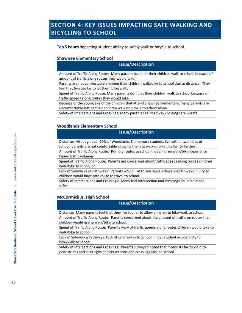
Top 5 issues impacting student ability to safely walk or bicycle to school.
Shawnee Elementary School
Issue/Description
Amount of Traffic Along Route: Many parents don’t let their children walk to school because of amount of traffic along routes they would take.
Parents are not comfortable allowing their children walk/bike to school due to distance. They feel they live too far to let them bike/walk.
Speed of Traffic Along Route: Many parents don’t let their children walk to school because of traffic speeds along routes they would take.
Because of the young age of the children that attend Shawnee Elementary, many parents are uncomfortable letting their children walk or bicycle to school alone.
Safety of Intersections and Crossings: Many parents feel roadway crossings are unsafe.
Woodlands Elementary School
Issue/Description
Distance: Although over 60% of Woodlands Elementary students live within two miles of school, parents are not comfortable allowing them to walk or bike this far (or farther).
Amount of Traffic Along Route: Primary routes to school that children walk/bike experience heavy traffic volumes.
Speed of Traffic Along Route: Parents are concerned about traffic speeds along routes children walk/bike to school on.
Lack of Sidewalks or Pathways: Parents would like to see more sidewalks/pathways in City so children would have safe route to travel to school.
Safety of Intersections and Crossings: Many feel intersection and crossings could be made safer.
McCormick Jr. High School
Issue/Description
Distance: Many parents feel that they live too far to allow children to bike/walk to school.
Amount of Traffic Along Route: Parents concerned about the amount of traffic on routes that children would use to walk/bike to school.
Speed of Traffic Along Route: Parents wary of traffic speeds along routes children would take to walk/bike to school.
Lack of Sidewalks/Pathways: Lack of safe routes to school hinder student accessibility to bike/walk to school.
Safety of Intersections and Crossings: Parents surveyed noted that motorists fail to yield to pedestrians and stop signs at intersections and crossings around school.
SECTION 4: KEY ISSUES IMPACTING SAFE WALKING AND BICYCLING TO SCHOOL

| Ohio’s Safe Routes to School Travel Plan Tem
plate | w
ww.dot.state.oh.us/saferoutes
14
5A. Non‐infrastructure Countermeasure Recommendations EDUCATION COUNTERMEASURES: List and describe the education strategies that your team plans to implement in the next 12 months in the table below.
EDUCATION
Issue Countermeasure
Teach proper safety for bicycling/walking to school
Start a bicycle rodeo program
Safety Town/Safety Assemblies
Utilize ODOT’s “Every Move You Make, Make it Safe” campaign to educate students (and parents” about the proper ways to walk and bicycle to school
Distance perception Host informational meeting for parents/neighbors, etc. on SRTS program
Increase knowledge of rail safety Implement Rail Safety Program at all schools to educate students on proper rail crossing techniques
Educate Benefits of Bicycling and Walking Partner with MPO to educate students on active forms of transportation and its benefits
List the medium and long term strategies (those that your team will undertake beyond 12 months) below: 1. Continue Safety Town program. 2. Continue to work with SRTS partners to promote benefits of healthy lifestyle
choices. 3. Continue to enhance opportunities for pedestrian and bicycle activities into school
curriculum.
ENCOURAGEMENT COUNTERMEASURES: List and describe the encouragement strategies that your team plans to implement in the next 12 months in the table below.
ENCOURAGEMENT Issue Countermeasure
Bicycle and Walking Encouragement Participate in Walk/Bike to school days
Start a walking and bicycling school bus program
Develop mileage clubs
Develop student safety patrol
List the medium and long term strategies (those that your team will undertake beyond 12 months) below: 1. Consider tying in Walking/Biking School Bus volunteers into citizens with weight
loss goals at the Erie County Health Department. 2. Consider establishing “walk with a principal” or “walk with a policeman” program.
3. Update walking and bicycling school bus routes at the beginning of each school year.
SECTION 5: RECOMMENDED SRTS COUNTERMEASURES
| Ohio’s Safe Routes to School Travel Plan Tem
plate | w
ww.dot.state.oh.us/saferoutes
15
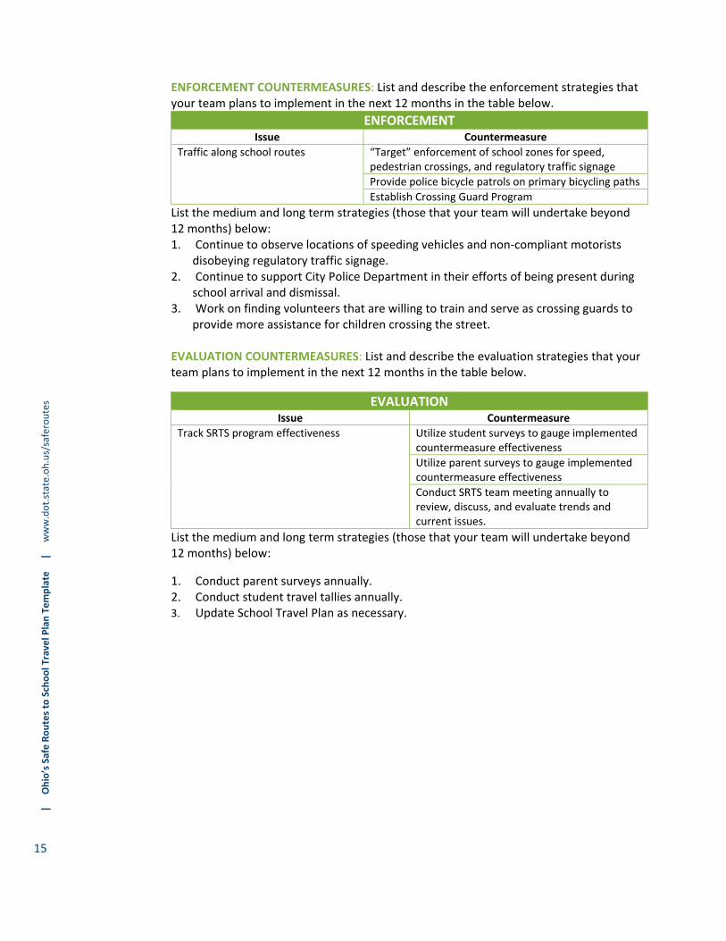
ENFORCEMENT COUNTERMEASURES: List and describe the enforcement strategies that your team plans to implement in the next 12 months in the table below.
ENFORCEMENT Issue Countermeasure
Traffic along school routes “Target” enforcement of school zones for speed,pedestrian crossings, and regulatory traffic signage
Provide police bicycle patrols on primary bicycling paths
Establish Crossing Guard Program
List the medium and long term strategies (those that your team will undertake beyond 12 months) below: 1. Continue to observe locations of speeding vehicles and non‐compliant motorists
disobeying regulatory traffic signage. 2. Continue to support City Police Department in their efforts of being present during
school arrival and dismissal. 3. Work on finding volunteers that are willing to train and serve as crossing guards to
provide more assistance for children crossing the street.
EVALUATION COUNTERMEASURES: List and describe the evaluation strategies that your team plans to implement in the next 12 months in the table below.
EVALUATION
Issue Countermeasure
Track SRTS program effectiveness Utilize student surveys to gauge implemented countermeasure effectiveness
Utilize parent surveys to gauge implemented countermeasure effectiveness
Conduct SRTS team meeting annually to review, discuss, and evaluate trends and current issues.
List the medium and long term strategies (those that your team will undertake beyond 12 months) below:
1. Conduct parent surveys annually. 2. Conduct student travel tallies annually. 3. Update School Travel Plan as necessary.

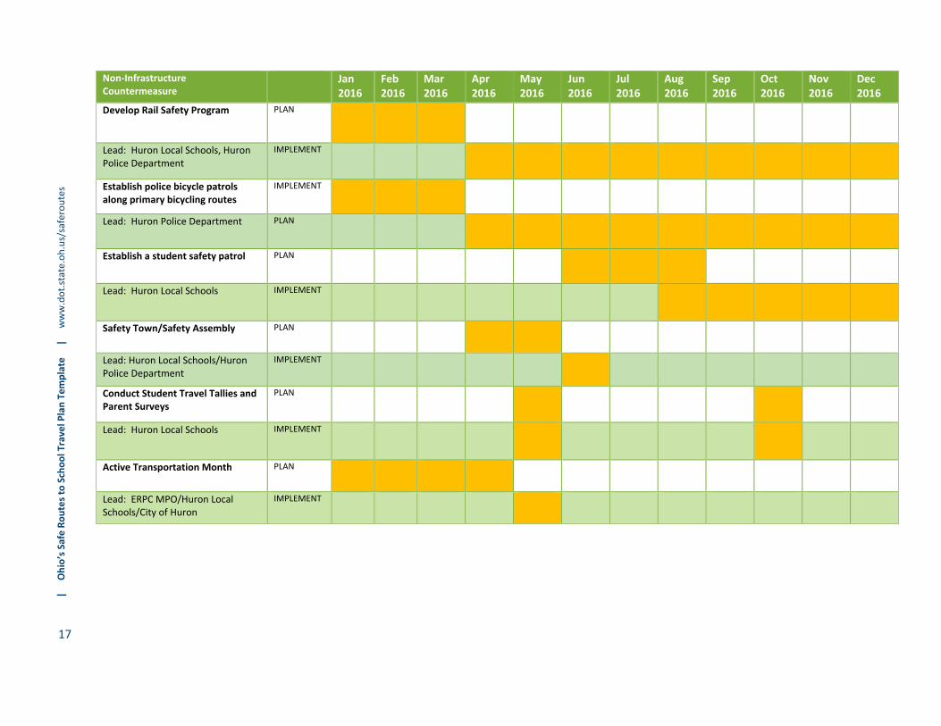
5B. 12‐Month SRTS Non‐Infrastructure Activity Calendar
Non‐Infrastructure Countermeasure
Jan 2016
Feb 2016
Mar 2016
Apr 2016
May 2016
Jun 2016
Jul 2016
Aug 2016
Sep 2016
Oct 2016
Nov 2016
Dec 2016
Establish Walking and Biking School Bus Program
PLAN
Lead: Huron Local Schools IMPLEMENT
Establish Crossing Guard Program PLAN
Lead: Huron Local Schools IMPLEMENT
Participate in Walk/Bike to school days
PLAN
Lead: Huron Local Schools IMPLEMENT
Target Enforcement of School Zones for speed, pedestrian crossings, and regulatory traffic signage
PLAN
Lead: City of Huron Police IMPLEMENT
Utilize ODOT’s “Every Move You Make, Make it Safe” campaign
PLAN
Lead: Huron Local Schools/City of Huron/ERPC MPO
IMPLEMENT
Host informational SRTS Meeting PLAN
Lead: Huron Local Schools/City of Huron
IMPLEMENT
Start a Bike Rodeo Program PLAN
Lead: Huron Local Schools/ERPC MPO/Huron Police Department/City of Huron
IMPLEMENT
Develop mileage clubs PLAN
Lead: Huron Local Schools IMPLEMENT
| Ohio’s Safe Routes to School Travel Plan Tem
plate | w
ww.dot.state.oh.us/saferoutes
17
Non‐Infrastructure Countermeasure
Jan2016
Feb2016
Mar2016
Apr2016
May2016
Jun2016
Jul2016
Aug2016
Sep2016
Oct2016
Nov2016
Dec2016
Develop Rail Safety Program PLAN
Lead: Huron Local Schools, Huron Police Department
IMPLEMENT
Establish police bicycle patrols along primary bicycling routes
IMPLEMENT
Lead: Huron Police Department PLAN
Establish a student safety patrol PLAN
Lead: Huron Local Schools IMPLEMENT
Safety Town/Safety Assembly PLAN
Lead: Huron Local Schools/Huron Police Department
IMPLEMENT
Conduct Student Travel Tallies and Parent Surveys
PLAN
Lead: Huron Local Schools IMPLEMENT
Active Transportation Month PLAN
Lead: ERPC MPO/Huron Local Schools/City of Huron
IMPLEMENT

| Ohio’s Safe Routes to School Travel Plan Tem
plate | w
ww.dot.state.oh.us/saferoutes
18
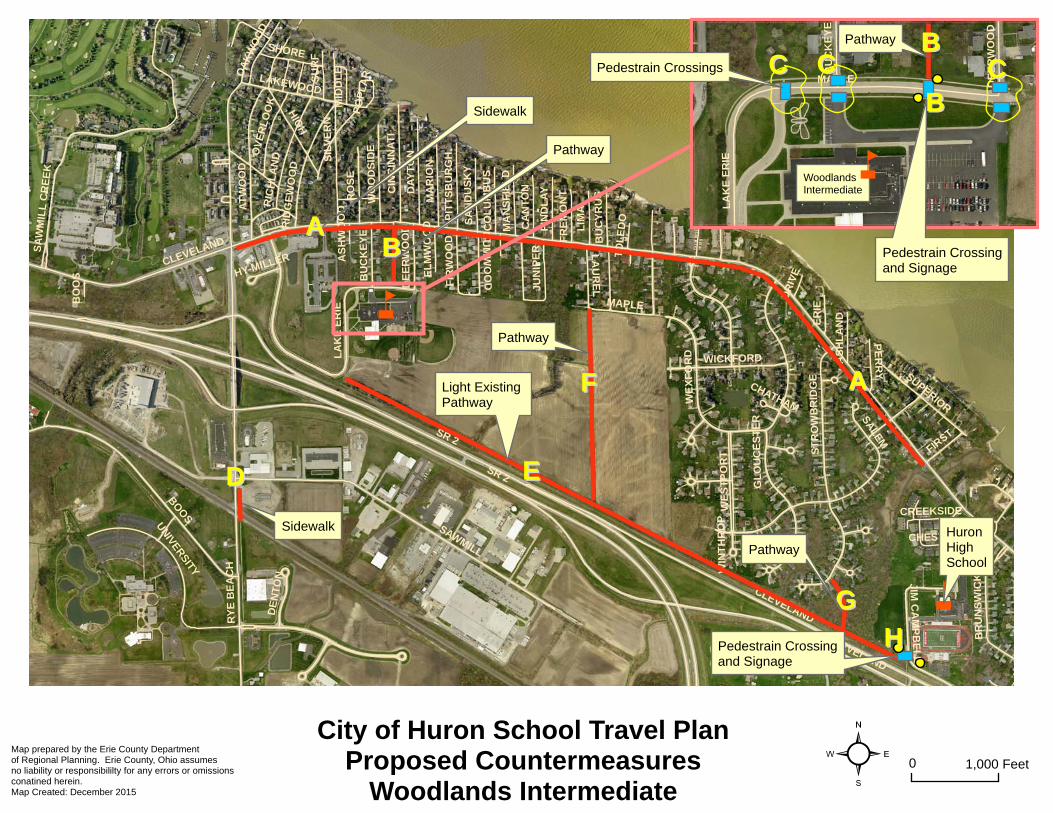
5C. Infrastructure Countermeasure Recommendations
Map ID
Location Issue Countermeasure Timeframe Priority Jurisdiction Responsible
Estimated Cost
Possible Funding Source
Status
A Cleveland Road from Rye Beach Road to First Street
Lack of sidewalks Install sidewalk along south side of road
Short High City of Huron High ODOT SRTSERPC MPO City of Huron
B Between Catalpa Road and Lake Erie Parkway
Lack of safe routes for children to bike/walk to school
Install new bicycle/ pedestrian only pathway to provide off street facility with pedestrian crossing and signage at Lake Erie Parkway
Short High City of Huron Medium ODOT SRTSERPC MPO City of Huron
Proposed project would lie on City owned property, no right of way required
C Lake Erie Parkway
Low pedestrian crosswalk visibility
Upgrade pedestrian crosswalks and signage at 3 locations along Lake Erie Parkway (north side of school)
Short High Huron Local Schools, City of Huron
Low ODOT SRTSERPC MPO City of Huron
D Rye Beach Road just south of Sawmill Parkway
Gap in sidewalk network
Install new sidewalk along east side of road
Short High City of Huron Medium ODOT SRTSERPC MPO City of Huron
E Existing paved pathway located behind Woodlands Elementary that connects to Jim Campbell Boulevard
Path is dark Install lighting along existing paved path
Short High City of Huron Low ODOT SRTSERPC MPO City of Huron
City of Huron installed this paved path about 2 years ago. Electric poles already existing along path.

| Ohio’s Safe Routes to School Travel Plan Tem
plate | w
ww.dot.state.oh.us/saferoutes
19
Map ID
Location Issue Countermeasure Timeframe Priority Jurisdiction Responsible
Estimated Cost
Possible Funding Source
Status
F From existing paved pathway to Laurel Avenue/Maple Avenue intersection
Lack of safe route for children to bike/walk to school
Install new lighted bicycle/pedestrian pathway connecting to existing paved pathway
Medium High City of Huron Medium ODOT SRTSERPC MPO City of Huron
G From existing paved pathway to Strowbridge Drive
Existing path is loose gravel
Pave over existing path to provide safer connection to the existing paved pathway
Short High City of Huron Low ODOT SRTSERPC MPO City of Huron
H Jim Campbell Boulevard at existing paved pathway/pedestrian bridge over US 6
No pedestrian crossing or signage
Install crosswalk with pedestrian crossing signage
Short High City of Huron Low ODOT SRTSERPC MPO City of Huron
I Ohio Street Increase motorists awareness of pedestrian crossing
Upgrade pedestrian crossing signage/install flashing beacon
Short High City of Huron Low ODOT SRTSERPC MPO City of Huron
J Ohio Street Improve crosswalk visibility in front of school
Upgrade pavement markings at crosswalks to ladder style to improve visibility and install “yield to pedestrian” signage in crosswalk
Short High City of Huron Low ODOT SRTSERPC MPO City of Huron
K McCormick School driveways facing Ohio Street
No pedestrian crossing Install crosswalk Short High Huron Local Schools, City of Huron
Low ODOT SRTSERPC MPO City of Huron

| Ohio’s Safe Routes to School Travel Plan Tem
plate | w
ww.dot.state.oh.us/saferoutes
20
Map ID
Location Issue Countermeasure Timeframe Priority Jurisdiction Responsible
Estimated Cost
Possible Funding Source
Status
L Various intersections located along Jim Campbell Street, Ohio Street, Cleveland Road, and Center Street
Lack of or low visibility of pedestrian crosswalks
Install/upgrade crosswalk pavement markings and signage
Short High City of Huron Medium ODOT SRTS ERPC MPO City of Huron
M Center Street from Standard Street to Wilbor Avenue
Gaps in the sidewalk network
Install new sidewalk along east and west side of Center Street to connect to existing sidewalks
Short High City of Huron Medium ODOT SRTSERPC MPO City of Huron
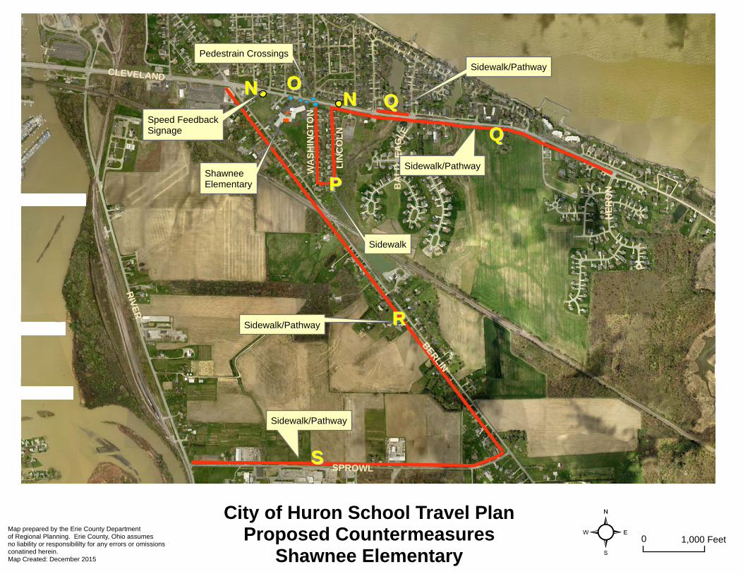
N Cleveland Road just east of Berlin Road
Speeding vehicles in school zones
Install radar feedback speed signs
Short High City of Huron Low ODOT SRTSERPPC MPO City of Huron
O Cleveland Road at school driveways, Washington Avenue, and Kiwanis Avenue
Lack of or low visibility of pedestrian crossings
Install/upgrade crosswalk pavement markings and signage
Short High City of Huron, Huron Local Schools
Low ODOT SRTSERPC MPO City of Huron
P Washington Avenue and Lincoln Avenue
Lack of sidewalks Install new sidewalks Medium High City of Huron High ODOT SRTSERPC MPO City of Huron
Q Cleveland Road from Lincoln Avenue to Heron Drive
Lack of sidewalks Install new sidewalk along south side of road, and fill in gap in network along north side from Gateway Boulevard to Anchorage Drive
Long High City of Huron,Huron Township
High ODOT SRTSERPC MPO City of Huron Huron Township

| Ohio’s Safe Routes to School Travel Plan Tem
plate | w
ww.dot.state.oh.us/saferoutes
21
Map ID
Location Issue Countermeasure Timeframe Priority Jurisdiction Responsible
Estimated Cost
Possible Funding Source
Status
R Berlin Road from Cleveland Road to Sprowl Road
Lack of sidewalks Install new sidewalk along west side of Berlin Road
Long High City of Huron, Huron Township
High ODOT SRTSERPC MPO City of Huron Huron Township
S Sprowl Road from Berlin Road to River Road
Lack of sidewalks Install new sidewalk along north side of Berlin Road
Long High City of Huron High ODOT SRTSERPC MPO City of Huron

See Step 6 of the STP Guide for instructions on how to complete this Section.
NOTE: In addition to the information requested in the table below, attach a copy of your public meeting notice.
Public Input Process: Public Meeting
Date: December 7, 2015
Target Audience: Parents, Teachers, Safe Routes Steering Committee, Residents
Key Input Received:
School Resource Officer stated that the reported number of students walking from McCormick Jr. High School doubling in the afternoon to over 20% seemed about right from his observations. He also stated the police department has bicycles, he used to be on bicycle patrol himself and thought that may be good initiative to begin again.
Principal of Woodlands Intermediate voiced he was very supportive of creating a separate path off of Catalpa Drive, would allow children to use path and get them off of Buckeye and Deerwood streets, which buses use regularly to access the school.
All attendees felt the recommended plan improvements would be beneficial to those children bicycling and walking and work to encourage more to walk/bike.
SECTION 6: PUBLIC INPUT
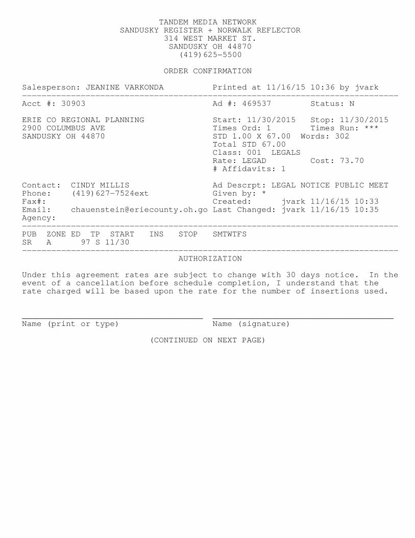
TANDEM MEDIA NETWORKSANDUSKY REGISTER + NORWALK REFLECTOR
314 WEST MARKET ST.SANDUSKY OH 44870(419)625−5500
ORDER CONFIRMATION
Salesperson: JEANINE VARKONDA Printed at 11/16/15 10:36 by jvark−−−−−−−−−−−−−−−−−−−−−−−−−−−−−−−−−−−−−−−−−−−−−−−−−−−−−−−−−−−−−−−−−−−−−−−−−−−−−Acct #: 30903 Ad #: 469537 Status: N
ERIE CO REGIONAL PLANNING Start: 11/30/2015 Stop: 11/30/20152900 COLUMBUS AVE Times Ord: 1 Times Run: ***SANDUSKY OH 44870 STD 1.00 X 67.00 Words: 302
Total STD 67.00Class: 001 LEGALSRate: LEGAD Cost: 73.70# Affidavits: 1
Contact: CINDY MILLIS Ad Descrpt: LEGAL NOTICE PUBLIC MEETPhone: (419)627−7524ext Given by: *Fax#: Created: jvark 11/16/15 10:33Email: [email protected] Last Changed: jvark 11/16/15 10:35Agency:−−−−−−−−−−−−−−−−−−−−−−−−−−−−−−−−−−−−−−−−−−−−−−−−−−−−−−−−−−−−−−−−−−−−−−−−−−−−−PUB ZONE ED TP START INS STOP SMTWTFSSR A 97 S 11/30−−−−−−−−−−−−−−−−−−−−−−−−−−−−−−−−−−−−−−−−−−−−−−−−−−−−−−−−−−−−−−−−−−−−−−−−−−−−−
AUTHORIZATION
Under this agreement rates are subject to change with 30 days notice. In theevent of a cancellation before schedule completion, I understand that therate charged will be based upon the rate for the number of insertions used.
_____________________________________ _____________________________________Name (print or type) Name (signature)
(CONTINUED ON NEXT PAGE)

TANDEM MEDIA NETWORKSANDUSKY REGISTER + NORWALK REFLECTOR
314 WEST MARKET ST.SANDUSKY OH 44870(419)625−5500
ORDER CONFIRMATION (CONTINUED)
Salesperson: JEANINE VARKONDA Printed at 11/16/15 10:36 by jvark−−−−−−−−−−−−−−−−−−−−−−−−−−−−−−−−−−−−−−−−−−−−−−−−−−−−−−−−−−−−−−−−−−−−−−−−−−−−−Acct #: 30903 Ad #: 469537 Status: N
LEGAL NOTICE PUBLIC MEETING TO GATHER
COMMENTS ABOUT THE HURON SAFE
ROUTES TO SCHOOLS TRAVEL PLAN
The Huron City School District, Cityof Huron, and Erie Regional
Planning Commission (ERPC), willconduct a public meeting on
Monday, December 7, 2015 togather public input about safe
routes to school needs for developing the Huron Safe Routesto School Travel Plan. The publicmeeting will be held at the Huron
High School Library, 710 ClevelandRoad West, Huron, Ohio beginning
at 5:30 p.m. In Ohio, the development of the School Travel
Plan (STP) is the first step in developing a Safe Routes to
School Program (SRTS). The STPis a written document that outlines
a community's intentions for enabling students to engage in
active transportation (i.e. walkingor bicycling) as they travel to and
from school. A successful Safe Routes to
School program is a sustained effort that involves bringing the rightmix of people together, identifying
the issues and finding ways to improve walking and bicycling
conditions. Safe Routes to Schoolprograms work to:
· Assess the safety of school travelroutes;
· Encourage more walking and bicycling to school through fun
promotions and events;· Make engineering changes such
as installing sidewalks, improvingstreet crossings and training
crossing guards;· Educate students, parents and
drivers about safe travel;· Promote safe walking and
bicycling throughout the community.
The recommendations for the DraftSTP will be presented at this public
meeting, and members of the community are encouraged to stopby and provide comments or have
questions answered. Public comments on the Draft STP will be
accepted through the close of business on December 21, 2015.For further information about the
public meeting, the draft plan update, or to submit public
comment, please contact ERPCstaff at (419) 627-7652.
November 30, 2015

| Ohio’s Safe Routes to School Travel Plan Tem
plate | w
ww.dot.state.oh.us/saferoutes
24
APPENDIX A: MAPPING


SR 2
RY
E B
EA
CH
BOO
S
CLEVELAND
SAWMILL
SALEM
AT
WO
OD
SIL
VE
RN
HIG
H
ST
RO
WB
RID
GE
UN
IVERSITY
RIC
HL
AN
D
WE
XF
OR
D
RO
SE
DA
YT
ON
SA
WM
ILL
CR
EE
K
JIM C
AM
PB
EL
L
MA
RIO
N
SUPERIOR
LIM
A
LAKEWOOD
WICKFORD
CIN
CIN
NA
TI
RID
GE
WO
OD
GL
OU
CE
ST
ER
LA
KE
ER
IE
MAPLE
BR
UN
SW
ICK
WE
ST
PO
RT
SU
RF
WO
OD
SID
E
ER
IE
FIRST
LA
UR
EL
PE
RR
Y
OV
ER
LO
OK
FIN
DL
AY
CA
NT
ON
JUN
IPE
R
FIR
WO
OD
BU
CK
EY
E
PIT
TS
BU
RG
H
SA
ND
US
KY
OA
KW
OO
D
BU
CY
RU
S
MA
NS
FIE
LD
DE
NT
ON
CO
LU
MB
US
GU
MW
OO
DDE
ER
WO
OD
FR
EM
ON
T
AS
HL
AN
D
MID
DL
E
SHORE
EL
MW
OO
D
CREEKSIDE
DR
IVE
CHESTNUT
PO
PL
AR
TO
LE
DO
HY-MILLER AS
HW
OO
D
CHATHAM
WIN
TH
RO
P
SR 2
CLEVELAND
BO
OS
CLEVELAND
²City of Huron School Travel PlanProposed Countermeasures
Woodlands Intermediate0 1,000 Feet
Map prepared by the Erie County Departmentof Regional Planning. Erie County, Ohio assumesno liability or responsibililty for any errors or omissionsconatined herein. Map Created: December 2015
n
Sidewalk
n
HuronHighSchool
MAPLE
LA
KE
ER
IE
BU
CK
EY
E
DE
ER
WO
OD
WoodlandsIntermediate
AA
AABB
BB
BBCC CCCC
DD
FF
EE
GG
Pathway
Pathway
Light Existing Pathway
Sidewalk
Pathway
Pedestrain Crossingand Signage
Pedestrain Crossingand Signage
Pedestrain Crossings
Pathway
n
HH

MAIN
CENTER
OHIO
CLEVELAND
ADAMS
WIL
LIAM
S
WILBOR
VINE
JIM CAMPBELL
HURO
N
WILDER
MILLS
STANDARD
STO
WE
SCO
TT
KLE
IN
SHIRLEY
BRUNSWICK
LIBE
RTY
POR
TLA
ND
VAN RENSALAERCLEVELAND
CLEVELAND
²City of Huron School Travel Plan
Proposed CountermeasuresMcCormick Jr. High
0 1,000 FeetMap prepared by the Erie County Departmentof Regional Planning. Erie County, Ohio assumesno liability or responsibililty for any errors or omissionsconatined herein. Map Created: December 2015
n
McCormickJr. High School
Huron PublicLibrary
Sidewalk
Pedestrian CrossingPedestrian CrossingsPedestrain Sigange/Flashing Beacon
Crosswalk Pavement Markings/Pedestrian Signage Upgrades
II
II
JJ
KK
LL
MM
Æc
²City of Huron School Travel Plan
Proposed CountermeasuresShawnee Elementary
0 1,000 FeetMap prepared by the Erie County Departmentof Regional Planning. Erie County, Ohio assumesno liability or responsibililty for any errors or omissionsconatined herein. Map Created: December 2015
n
CLEVELAND
RIV
ER
SPROWL
BER
LINW
AS
HIN
GT
ON
LIN
CO
LN
BA
LD
EA
GLE
HE
RO
N
Sidewalk/Pathway
Sidewalk/Pathway
Sidewalk/Pathway
Sidewalk/Pathway
Sidewalk
Speed FeedbackSignage
Pedestrain Crossings
NNNN
PP
OOQQ
RR
SS
Shawnee Elementary