
HUMANS AND ENVIRONMENT: CAUSE AND EFFECT ANALYSIS ... · HUMANS AND ENVIRONMENT: CAUSE AND EFFECT...
15
1 HUMANS AND ENVIRONMENT: CAUSE AND EFFECT ANALYSIS SUPPORTED BY SPATIAL DATA INFRASTRUCTURES Ulrike KLEIN 1 and Hartmut MÜLLER 2 1 Centre for Geoinformation, Christian-Albrechts-University Kiel, Germany 2 FH Mainz University of Applied Sciences, Mainz, Germany Humans and Environment: Cause and Effect Analysis Supported by Spatial Data Infrastructures Ulrike Klein and Hartmut Müller INTERACTIONS BETWEEN HUMANS AND ENVIRONMENT
Transcript of HUMANS AND ENVIRONMENT: CAUSE AND EFFECT ANALYSIS ... · HUMANS AND ENVIRONMENT: CAUSE AND EFFECT...

1
HUMANS AND ENVIRONMENT: CAUSE AND EFFECT ANALYSIS SUPPORTED BY SPATIAL DATA INFRASTRUCTURES
Ulrike KLEIN1 and Hartmut MÜLLER2
1Centre for Geoinformation, Christian-Albrechts-University Kiel, Germany2FH Mainz University of Applied Sciences, Mainz, Germany
Humans and Environment: Cause and Effect Analysis Supported by Spatial Data Infrastructures Ulrike Klein and Hartmut Müller
INTERACTIONS BETWEEN HUMANS AND ENVIRONMENT
2
Humans and Environment: Cause and Effect Analysis Supported by Spatial Data Infrastructures Ulrike Klein and Hartmut Müller
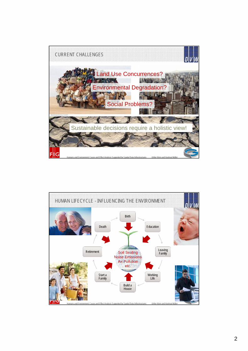
CURRENT CHALLENGES
Land Use Concurrences?
Environmental Degradation?
Social Problems?
Sustainable decisions require a holistic view!
dailygalaxy.com
Humans and Environment: Cause and Effect Analysis Supported by Spatial Data Infrastructures Ulrike Klein and Hartmut Müller
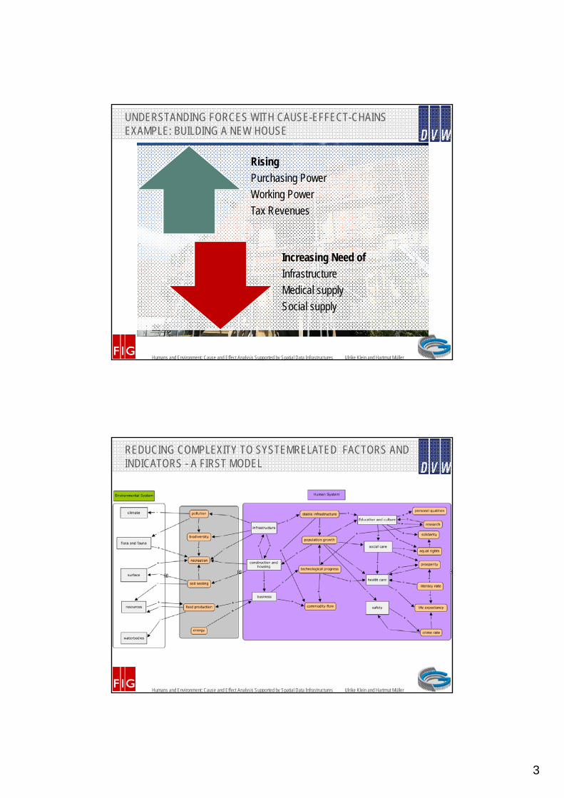
Birth
Education
LeavingFamliy
Working Life
Build a House
Start a Family
Retirement
Death
HUMAN LIFECYCLE - INFLUENCING THE ENVIRONMENT
Soil SealingNoise Emissions
Air Pollutionetc.
3
Humans and Environment: Cause and Effect Analysis Supported by Spatial Data Infrastructures Ulrike Klein and Hartmut Müller
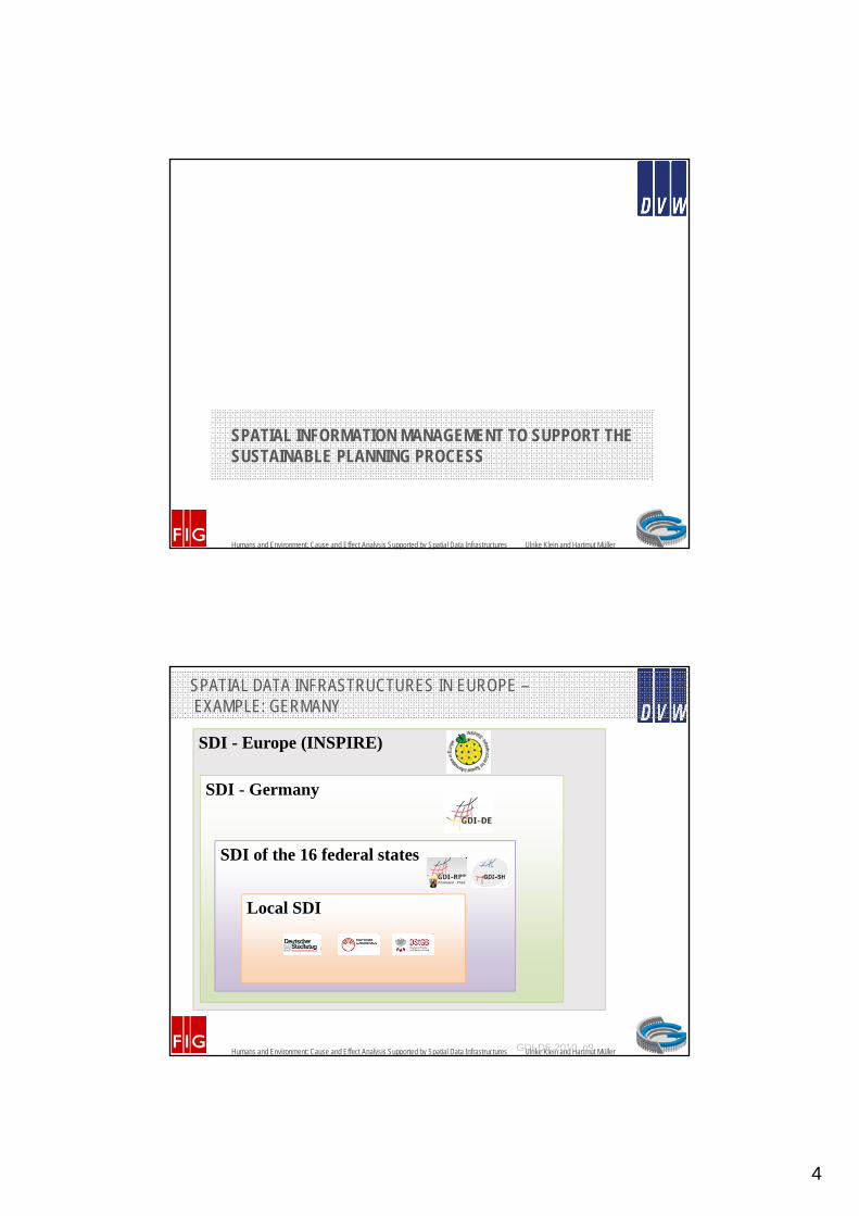
UNDERSTANDING FORCES WITH CAUSE-EFFECT-CHAINS EXAMPLE: BUILDING A NEW HOUSE
Rising
Purchasing Power
Working Power
Tax Revenues
Increasing Need of
Infrastructure
Medical supply
Social supply
Humans and Environment: Cause and Effect Analysis Supported by Spatial Data Infrastructures Ulrike Klein and Hartmut Müller
REDUCING COMPLEXITY TO SYSTEMRELATED FACTORS AND INDICATORS - A FIRST MODEL
4
Humans and Environment: Cause and Effect Analysis Supported by Spatial Data Infrastructures Ulrike Klein and Hartmut Müller
SPATIAL INFORMATION MANAGEMENT TO SUPPORT THE SUSTAINABLE PLANNING PROCESS
Humans and Environment: Cause and Effect Analysis Supported by Spatial Data Infrastructures Ulrike Klein and Hartmut Müller
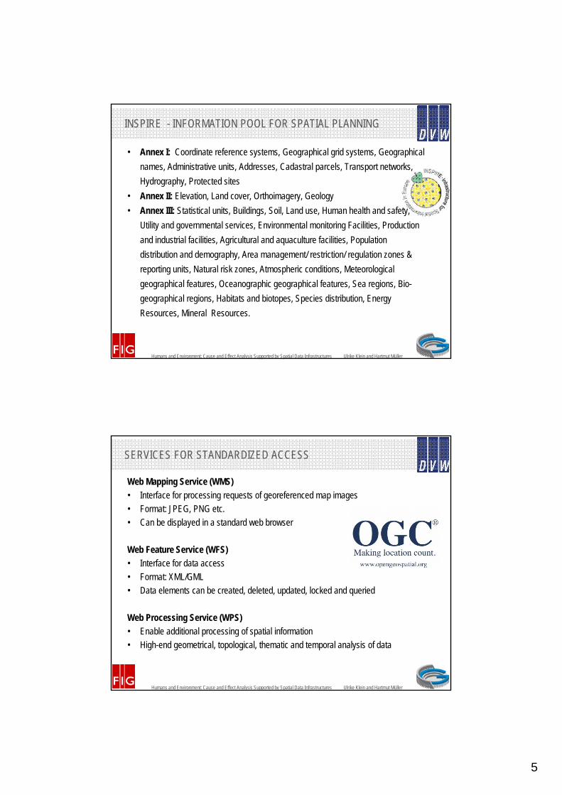
SDI - Europe (INSPIRE)
SPATIAL DATA INFRASTRUCTURES IN EUROPE –EXAMPLE: GERMANY
SDI - Germany
SDI of the 16 federal states
Local SDI
GDI-DE 2010, p9
5
Humans and Environment: Cause and Effect Analysis Supported by Spatial Data Infrastructures Ulrike Klein and Hartmut Müller
INSPIRE - INFORMATION POOL FOR SPATIAL PLANNING
• Annex I: Coordinate reference systems, Geographical grid systems, Geographical
names, Administrative units, Addresses, Cadastral parcels, Transport networks,
Hydrography, Protected sites
• Annex II: Elevation, Land cover, Orthoimagery, Geology
• Annex III: Statistical units, Buildings, Soil, Land use, Human health and safety,
Utility and governmental services, Environmental monitoring Facilities, Production
and industrial facilities, Agricultural and aquaculture facilities, Population
distribution and demography, Area management/ restriction/ regulation zones &
reporting units, Natural risk zones, Atmospheric conditions, Meteorological
geographical features, Oceanographic geographical features, Sea regions, Bio-
geographical regions, Habitats and biotopes, Species distribution, Energy
Resources, Mineral Resources.
Humans and Environment: Cause and Effect Analysis Supported by Spatial Data Infrastructures Ulrike Klein and Hartmut Müller
SERVICES FOR STANDARDIZED ACCESS
Web Mapping Service (WMS)
• Interface for processing requests of georeferenced map images
• Format: JPEG, PNG etc.
• Can be displayed in a standard web browser
Web Feature Service (WFS)
• Interface for data access
• Format: XML/GML
• Data elements can be created, deleted, updated, locked and queried
Web Processing Service (WPS)
• Enable additional processing of spatial information
• High-end geometrical, topological, thematic and temporal analysis of data

6
Humans and Environment: Cause and Effect Analysis Supported by Spatial Data Infrastructures Ulrike Klein and Hartmut Müller
CASE STUDY: USE CASE BUILDING A NEW HOUSE I. ANALYSING AND MODELLING SPATIAL RELATIONSHIPS FOR SUSTAINABLE PLANNING
Humans and Environment: Cause and Effect Analysis Supported by Spatial Data Infrastructures Ulrike Klein and Hartmut Müller
PART 1: ASPECTS OF SUSTAINABILITY –INDICATORS AND CRITERIA FOR SUSTAINABLE PLANNING
Ecological IndicatorsWaste Soil Energy and resources
Land use Noise Settlement development Air Nature conservation Natural scenery and
landscapeWaterEconomical Indicators
Employment Education Supply of servicesAgriculture and forestry Accessibility Regional products
Economic structures Economic development Public budgetSocial Indicators
Population developmentCivic and democratic
engagement;Individual mobility and
public transportRecreation Family and child care Health
Socially responsible business
Inter-municipal cooperation Distribution of income
Culture, cultural heritage Participation SeniorsSafety Daily Supply Distribution of work
Living space Equal rightsHeiland et al. 2003, p. 203

7
Humans and Environment: Cause and Effect Analysis Supported by Spatial Data Infrastructures Ulrike Klein and Hartmut Müller
PART 1: ASPECTS OF SUSTAINABILITY –INDICATORS AND CRITERIA FOR SUSTAINABLE PLANNING
Ecological criteria:• Reduction of primary energy consumption and increasing use of renewable energy• Improvement of water quality• Promotion of biodiversity, enhancement and maintenance of protected areas• Improvement of soil quality and conservation of sensitive soils• Improvement of air quality• Avoidance of urban sprawlSocially criteria:• Creating good housing and living conditions and strengthening less-favoured areas• Evaluate and manage the cultural heritage• Improve mobilityEconomically criteria:• Improving the business environment and promoting jobs• Strengthening the financial capacity of the municipality.
Behrendt 2010, p. 114
Humans and Environment: Cause and Effect Analysis Supported by Spatial Data Infrastructures Ulrike Klein and Hartmut Müller
PART 2: HUMAN NEEDS (MASLOWS HIERACHY)
Maslows hierarchy of needs. Source: Wikipedia

8
Humans and Environment: Cause and Effect Analysis Supported by Spatial Data Infrastructures Ulrike Klein and Hartmut Müller
• Healthy living and working conditions,
• Safety,
• Housing needs of the population,
• Social and cultural needs,
• Maintenance and development of existing districts and central supply areas,
• Interests of architectural culture, heritage protection and preservation,
• Requirements for worship and pastoral care,
• Requirements of environmental protection
• Satisfaction of elementary needs and mobility of the population,• Etc.
PART 3: THE PLANNING RULES
Example of a legally binding land use plan of the study area
Humans and Environment: Cause and Effect Analysis Supported by Spatial Data Infrastructures Ulrike Klein and Hartmut Müller
PART 4: THE BUILDING PERMIT: SPATIAL RELATIONS BETWEEN HUMANS, ENVIRONMENT AND THE NEW BUILDING

9
Humans and Environment: Cause and Effect Analysis Supported by Spatial Data Infrastructures Ulrike Klein and Hartmut Müller
RESULT I: CAUSE-EFFECT CHAIN FOR BUILDING A NEW HOUSE
Causes:New house: new citizens, new cars, new tax revenues, new purchase power, new working power
Affecting an increasing need of:Ecologically: soil, energy, water, resources, land use, solid waste disposal, waste water disposal, rain water disposalEconomically: employment, education, supply of services, agriculture and forestry, foods and goods, government, industry, transport network, regional productsSocially: recreation, entertainment, child care, health care
Causing impact on:Ecologically: air quality, water quality, soil quality, use of resources, use of land, occurrence of species, biodiversity, protection of natural resources, landscape, nature conservation, settlement development, volume of wasteEconomically: accessibility, use of supply, public budget, settlement development, economic structure, economic developmentSocially: population development, distribution of income, participation, distribution of work, healthy living and working conditions, safety, culture protection, individual mobility
Affecting:Ecologically: soil sealing, air pollution, water pollution, emissions, resource consumption, energy consumption, contamination, number of species, noiseEconomically: financial capacity of the municipality, attractiveness for business and industrySocially: physiological needs, safety, social needs, individual needs, self‐realisation
Sustainability Responses:Ecologically: reduction of primary energy consumption, increasing renewable energies, improve water quality, promotion of biodiversity, enhancement of protected areas, improve soil quality, improve air quality, avoidance of urban sprawlEconomically: improving the business environment and promotion of jobs, strengthen the financial capacity of the municipalitySocially: creating good housing and living conditions, strengthening less‐favoured areas, evaluate and manage the cultural heritage, improve mobility
Humans and Environment: Cause and Effect Analysis Supported by Spatial Data Infrastructures Ulrike Klein and Hartmut Müller
CASE STUDY: USE CASE BUILDING A NEW HOUSE II. SUPPORT FOR CAUSE AND EFFECT ANALYSIS BY SPATIAL DATA INFRASTRUCTURES
10
Humans and Environment: Cause and Effect Analysis Supported by Spatial Data Infrastructures Ulrike Klein and Hartmut Müller
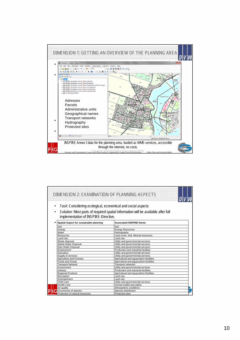
DIMENSION 1: GETTING AN OVERVIEW OF THE PLANNING AREA
• Task: Planners and descion-makers need overview of the situation before starting the planning process
• Solution: Combining avaliable INSPIRE-WMS-Services in a Geoportal or Spatial Information System
• Pro: availibality of data, free access through internet, data from different sources combined in one layer
• Contra: no analysis supported, no cartographic methods supported, no changes allowed
AdressesParcelsAdministrative unitsGeographical namesTransport networksHydrographyProtected sites
INSPIRE Annex I data for the planning area, loaded as WMS-services, accessible through the internet, no costs.
Data source: Schleswig-Holsteins State Surveying Authority.
Humans and Environment: Cause and Effect Analysis Supported by Spatial Data Infrastructures Ulrike Klein and Hartmut Müller
Example Population: Average income per capita projected on municipal boundaries. Data source: Department of Statistic North, Schleswig-Holsteins State Surveying Authority
DIMENSION 2: EXAMINATION OF PLANNING ASPECTS
• Task: Considering ecological, economical and social aspects
• Solution: Most parts of required spatial information will be available after full implementation of INSPIRE-Directive.
• Available non-spatial information can be projected on spatial objects, e.g. municipal boundaries
Spatial Aspect for sustainable planning Associated INSPIRE theme
Soil SoilEnergy Energy ResourcesWater HydrographyResources Land cover, Soil, Mineral resourcesLand Use Land useWaste disposal Utility and governmental servicesWaste Water Disposal Utility and governmental servicesRain Water Disposal Utility and governmental servicesEmployment Production and industrial facilitiesEducation Utility and governmental servicesSupply of services Utility and governmental servicesAgriculture and Forestry Agricultural and aquaculture facilitiesFoods and Goods Agricultural and aquaculture facilitiesTransport Network Transport networksGovernment Utility and governmental servicesIndustry Production and industrial facilitiesRegional Products Agricultural and aquaculture facilitiesRecreation Land useEntertainment Land useChild Care Utility and governmental servicesHealth Care Human health and safetyAir quality Atmospheric conditionsOccurrence of species Species distributionProtection of natural resources Protected sites

11
Humans and Environment: Cause and Effect Analysis Supported by Spatial Data Infrastructures Ulrike Klein and Hartmut Müller
DIMENSION 3: ANALYSIS OF SPATIAL CONNECTIONS
• Task: Identifying spatial connections concerning the planning area
• Solution: Using spatial tools like buffers or point-in-polygon-analysis to analyze spatial relationships between causes and effects
• Precondition: Spatial Data is availiable in WebFeatureServices (WFS)
Spatial analysis for spatial relationships. Example: potential emissions. Data Source: Schleswig-Holsteins State Surveying Authority (aerial photography), Ministry of the Environment Schleswig-
Holstein (noise), fictitious data for biogas plants and planned sites.
Humans and Environment: Cause and Effect Analysis Supported by Spatial Data Infrastructures Ulrike Klein and Hartmut Müller
DIMENSION 4: MEASURING THE IMPACT
• Task: Summarizing spatial effects to a holistic impact factor
• Solution: Using WebProcessingServices to orchestrate WFS-Services and to create complex applications to automate requests on impact factors
• Preconditions: Availability of WFS-Services, GIS-Professionals to define the process
Automatically generated environmental impact of house building.Data Source: Schleswig-Holsteins State Surveying Authority (aerial photography), fictitious data for the impact.
12
Humans and Environment: Cause and Effect Analysis Supported by Spatial Data Infrastructures Ulrike Klein and Hartmut Müller
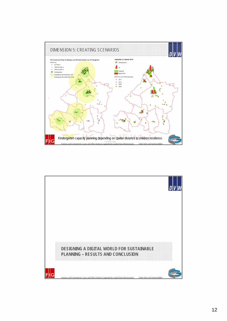
DIMENSION 5: CREATING SCENARIOS
• Task: Simulating population change or climate change
• Solution: Using spatial tools or WPS to analyze and simulate different scenarios
• Precondition: Data available through WFS
• Example: Available ressources and capacity-planning for Kindergartens
Kindergarten capacity planning depending on spatial distance to children residence. Fictitious data.
Humans and Environment: Cause and Effect Analysis Supported by Spatial Data Infrastructures Ulrike Klein and Hartmut Müller
DESIGNING A DIGITAL WORLD FOR SUSTAINABLE PLANNING – RESULTS AND CONCLUSION

13
Humans and Environment: Cause and Effect Analysis Supported by Spatial Data Infrastructures Ulrike Klein and Hartmut Müller
REMEMBER RESULT I:CAUSE-EFFECT CHAIN FOR BUILDING A NEW HOUSE
Causes:New house: new citizens, new cars, new tax revenues, new purchase power, new working power
Affecting an increasing need of:Ecologically: soil, energy, water, resources, land use, solid waste disposal, waste water disposal, rain water disposalEconomically: employment, education, supply of services, agriculture and forestry, foods and goods, government, industry, transport network, regional productsSocially: recreation, entertainment, child care, health care
Causing impact on:Ecologically: air quality, water quality, soil quality, use of resources, use of land, occurrence of species, biodiversity, protection of natural resources, landscape, nature conservation, settlement development, volume of wasteEconomically: accessibility, use of supply, public budget, settlement development, economic structure, economic developmentSocially: population development, distribution of income, participation, distribution of work, healthy living and working conditions, safety, culture protection, individual mobility
Affecting:Ecologically: soil sealing, air pollution, water pollution, emissions, resource consumption, energy consumption, contamination, number of species, noiseEconomically: financial capacity of the municipality, attractiveness for business and industrySocially: physiological needs, safety, social needs, individual needs, self‐realisation
Sustainability Responses:Ecologically: reduction of primary energy consumption, increasing renewable energies, improve water quality, promotion of biodiversity, enhancement of protected areas, improve soil quality, improve air quality, avoidance of urban sprawlEconomically: improving the business environment and promotion of jobs, strengthen the financial capacity of the municipalitySocially: creating good housing and living conditions, strengthening less‐favoured areas, evaluate and manage the cultural heritage, improve mobility
Humans and Environment: Cause and Effect Analysis Supported by Spatial Data Infrastructures Ulrike Klein and Hartmut Müller
RESULT II: FIRST LEVEL OF SPATIO-CYBERNETICCAUSE-EFFECT-CHAIN SUPPORTED BY SDI
14
Humans and Environment: Cause and Effect Analysis Supported by Spatial Data Infrastructures Ulrike Klein and Hartmut Müller
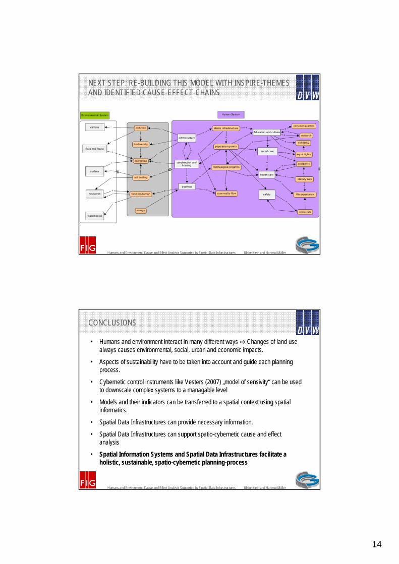
NEXT STEP: RE-BUILDING THIS MODEL WITH INSPIRE-THEMESAND IDENTIFIED CAUSE-EFFECT-CHAINS
Humans and Environment: Cause and Effect Analysis Supported by Spatial Data Infrastructures Ulrike Klein and Hartmut Müller
CONCLUSIONS
• Humans and environment interact in many different ways ⇨ Changes of land use always causes environmental, social, urban and economic impacts.
• Aspects of sustainability have to be taken into account and guide each planning process.
• Cybernetic control instruments like Vesters (2007) „model of sensivity“ can be used to downscale complex systems to a managable level
• Models and their indicators can be transferred to a spatial context using spatial informatics.
• Spatial Data Infrastructures can provide necessary information.
• Spatial Data Infrastructures can support spatio-cybernetic cause and effect analysis
• Spatial Information Systems and Spatial Data Infrastructures facilitate a holistic, sustainable, spatio-cybernetic planning-process

15
Humans and Environment: Cause and Effect Analysis Supported by Spatial Data Infrastructures Ulrike Klein and Hartmut Müller
THANK YOU FOR LISTENING
Prof. Dr. Hartmut Mü[email protected]
Dr. Ulrike [email protected]


