How the Dutch gas wealth turns into a crime scene
12
How a nation’s gas wealth turns into a nation’s crime scene The Groningen natural gas field Basic characteristics The Groningen gas field is located in the north-eastern part of the Netherlands. It spreads across an area of 900 km2, making it the largest field in Europe and the tenth-largest in the world. The field covers more than one third of the province of Groningen, which is rather densely populated (250 inhabitants per km2). The field was discovered by NAM (joint venture, 50% Shell and 50% ExxonMobil) in 1959. Initially, they thought the reservoir contained 60 BCM (billion square meter), but later it was found that the reservoir contained 2800 BCM. As of 2015, only 700 BCM (25% of the original contents) remains. In May 1963, a lifelong concession was granted to NAM for exploitation of the field. Management of production was arranged in Maatschap Groningen (60% NAM, 40% Dutch government). In the decade that followed, the government made sure all households in The Netherlands and many more in Germany, Belgium and France were hooked onto the grid for this so-called low-caloric “Groningen gas”. It is now widely used for cooking and heating. Dutch businesses and industry also depend on it. The Rotliegend sandstones of the Groningen gas reservoir are dissected by a large number of natural faults. These have been there for millions of years, but at least in the last 500 years did not cause any natural earthquakes. The field is located on the Groningen High, which has been a tectonically stable block since the late Kimmeridgian uplift. The current depth of the Rotliegend reservoir, around 2600-3200 mTVD (true vertical depth), reflects the maximum burial depth. The cap rock of the Groningen field is provided by the overlying Zechstein salt seal. Below: Cross-section of the Groningen gas field (Rotliegend)
-
Upload
chris-helweg -
Category
Presentations & Public Speaking
-
view
39 -
download
2
Transcript of How the Dutch gas wealth turns into a crime scene

How a nation’s gas wealth turns into a nation’s crime scene The Groningen natural gas field Basic characteristics The Groningen gas field is located in the north-eastern part of the Netherlands. It spreads across an area of 900 km2, making it the largest field in Europe and the tenth-largest in the world. The field covers more than one third of the province of Groningen, which is rather densely populated (250 inhabitants per km2). The field was discovered by NAM (joint venture, 50% Shell and 50% ExxonMobil) in 1959. Initially, they thought the reservoir contained 60 BCM (billion square meter), but later it was found that the reservoir contained 2800 BCM. As of 2015, only 700 BCM (25% of the original contents) remains. In May 1963, a lifelong concession was granted to NAM for exploitation of the field. Management of production was arranged in Maatschap Groningen (60% NAM, 40% Dutch government). In the decade that followed, the government made sure all households in The Netherlands and many more in Germany, Belgium and France were hooked onto the grid for this so-called low-caloric “Groningen gas”. It is now widely used for cooking and heating. Dutch businesses and industry also depend on it. The Rotliegend sandstones of the Groningen gas reservoir are dissected by a large number of natural faults. These have been there for millions of years, but at least in the last 500 years did not cause any natural earthquakes. The field is located on the Groningen High, which has been a tectonically stable block since the late Kimmeridgian uplift. The current depth of the Rotliegend reservoir, around 2600-3200 mTVD (true vertical depth), reflects the maximum burial depth. The cap rock of the Groningen field is provided by the overlying Zechstein salt seal. Below: Cross-section of the Groningen gas field (Rotliegend)

Earthquakes and subsidence due to gas extraction Pressure in the centre of the reservoir has dropped from 350 bar to 60-70 bar, and will be approx. 10 bar when all of the gas is extracted. This means that whereas the gas once flowed spontaneously to the wells, it now must be “sucked up” using huge compressors. Because of the decreasing reservoir pressure, the reservoir cannot bear the overlying sediments and compacts. Because compaction is not a smooth regular process, earthquakes occur. These induced earthquakes release energy. Although people have reported seismic events from the beginning of gas extraction, there is little data available before 1986, the year governmental body Royal Netherlands Meteoro-logical Institute (KNMI) started registering seismic activity in the Netherlands. Incidence and scale of quakes have increased tremendously over the years. Between 1986 and 2000, the average number of quakes with a magnitude of 2.0 or more on the Richter scale was less than 1 per year. Since then, this number has increased to 7 a year. (Below: Number of quakes in the Groningen field, per year)
Compaction also results in subsidence at the earth surface. How much subsidence to expect, is predicted using models. Based on a geomechanical model and a compaction coefficient measured in the laboratory, in 2003 NAM predicted total subsidence in the centre of the field would be 38 cm by 2040. Their model, which dates back to 1972, assumes a constant ratio between subsidence and pressure depletion rates. However, in 2007, independent subsidence analyst/researcher Adriaan Houtenbos, present-ed an empirical subsidence model. The model recognises the increase in the ratio between subsidence and pressure depletion rates, as measured in real life. It predicts over 60 cm in the centre of the field.

Subsidence influences the shallow groundwater table (already below sea level). Extra pump-ing stations and locks are needed to keep the groundwater at a level where foundations and cellars of buildings won’t turn to mush or rot. The Groningen field is very large and very complex. NAM hasn’t got an accurate model of the entire field, including aquifers, which may mean that water board districts place their pumping stations and locks in incorrect places. This in turn will upset ground water level further and aggravate irregular subsidence, causing extra damage due to sagging of buildings. Quakes have varied from below zero to 3.6 on the Richter scale. Though this may not sound alarming, the geological situation in Groningen makes quakes of this scale surprisingly dam-aging. Seismologists working with KNMI claim they occur at Rotliegend reservoir depth (3 km), but independent geologist Peter van der Gaag suggests that several quakes have oc-curred above or in the upper part of the Zechstein salt seal, where a variety of vertical faults is in place. If these faults are triggered by compaction caused by gas extraction, then energy is released very close to the surface. This would account for the fact that in some instances, even small quakes have been felt very distinctively by inhabitants, and have caused consid-erable damage. Rien Herber, professor of geo-energy at the University of Groningen, con-firms there are also faults in the top layer of the salt seal. Shallow quakes cause exponentially more damage than deep quakes, particularly in Groningen, with its unique site effect (the composition of the local geology). A large part of Groningen used to be a sedimentary basin and has naturally formed into land, now surrounded by dikes to keep the water out. The top layer consists of unconsolidated water saturated clay and peat, and, having hardly any cohesion, it is prone to wave-like motions during quakes. Tremors in this jellylike layer may result in uncharacteristically high peak ground accelerations, propelling the energy released over a large area. The damage to surface structures – houses, roads, schools - can be severe, even at relatively low Richter-scale readings.

Huizinge quake – a wake-up call Let’s look at the most severe quake thus far, which took place in August 2012, near Huizinge. People testify they saw and sensed widespread rippling of the topsoil. More than half of the brick buildings near the epicentre were damaged. KNMI measured 3.6 on the Richter scale. Other institutes, such as the German Geofon, which has one station near the Dutch border, measured 3.9. Richter only says something about the amount of energy released. It doesn’t say anything about the intensity, nor about the consequences for buildings. To measure intensity, one may use the European Macroseismic Scale. Though it is custom to conduct a door-to-door survey locally, KNMI seems to have based their findings (VI on the EMS scale) for this severe quake on data lodged on their website by 1350 citizens, without taking into account where these respondents are located in relation to the epicentre. Also, KNMI mentions evaluation of 2,000 damage reports, but doesn’t specify what information from these reports is used and how many of these reports were used. Furthermore, damage caused by subsidence and previous earthquakes is ignored in such reports, though it does render buildings weaker and aggravates the quake related damage. Based on the experiences of inhabitants of Middelstum (largest village near the Huizinge epicentre) and the actual damage sustained in that village, it can be concluded that the actual intensity on the EMS scale for this quake was VI-VII.
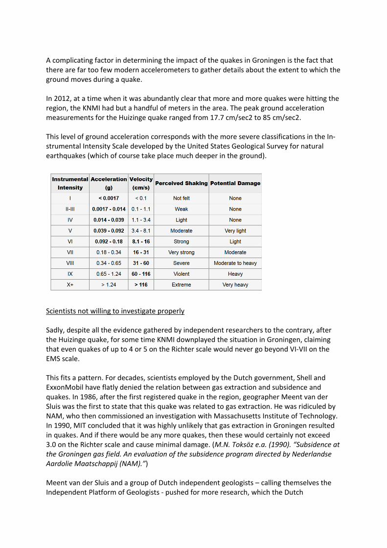
A complicating factor in determining the impact of the quakes in Groningen is the fact that there are far too few modern accelerometers to gather details about the extent to which the ground moves during a quake. In 2012, at a time when it was abundantly clear that more and more quakes were hitting the region, the KNMI had but a handful of meters in the area. The peak ground acceleration measurements for the Huizinge quake ranged from 17.7 cm/sec2 to 85 cm/sec2. This level of ground acceleration corresponds with the more severe classifications in the In-strumental Intensity Scale developed by the United States Geological Survey for natural earthquakes (which of course take place much deeper in the ground).
Scientists not willing to investigate properly Sadly, despite all the evidence gathered by independent researchers to the contrary, after the Huizinge quake, for some time KNMI downplayed the situation in Groningen, claiming that even quakes of up to 4 or 5 on the Richter scale would never go beyond VI-VII on the EMS scale. This fits a pattern. For decades, scientists employed by the Dutch government, Shell and ExxonMobil have flatly denied the relation between gas extraction and subsidence and quakes. In 1986, after the first registered quake in the region, geographer Meent van der Sluis was the first to state that this quake was related to gas extraction. He was ridiculed by NAM, who then commissioned an investigation with Massachusetts Institute of Technology. In 1990, MIT concluded that it was highly unlikely that gas extraction in Groningen resulted in quakes. And if there would be any more quakes, then these would certainly not exceed 3.0 on the Richter scale and cause minimal damage. (M.N. Toksöz e.a. (1990). “Subsidence at the Groningen gas field. An evaluation of the subsidence program directed by Nederlandse Aardolie Maatschappij (NAM).”) Meent van der Sluis and a group of Dutch independent geologists – calling themselves the Independent Platform of Geologists - pushed for more research, which the Dutch
government partly granted. In 1993, this resulted in a report called “Final multidisciplinary report investigation into relationship between gas extraction and earthquakes in the North of The Netherlands” (Begeleidingscommissie Onderzoek Aardbevingen, “Eindrapport multidisciplinair onderzoek naar de relatie tussen gaswinning en aardbevingen in Noord-Nederland.”) Contributors to this report where, amongst others, KNMI, NAM, SodM and Technical University Delft. It stated that under certain circumstances, gas extraction indeed did result in earthquakes. Using a statistical approach, based on a limited set of data, the authors concluded that such induced quakes would be very small, up to 3.3 on the Richter scale and cause minimal damage. Thus, they completely ignored that small quakes, such as a quake of 2.4 on the Richter scale in Middelstum in 1991, had already resulted in large cracks in walls and other considerable damage. The report did spur some development of 3D seismic models, though the basis of subsoil modelling stayed pretty much the same. NAM knew where the gas was trapped in the reservoir and how much was available for extraction. It seems they did not care to investigate what the consequences of this extraction would be. Shell and ExxonMobil co-operated with Technical University Delft for modelling. The latest study dates back to 2003 (thesis by F. Mulders, TU Delft, “Modelling of stress development and fault slip in and around a producing gas reservoir”). In 2004, in the report “Seismic hazard due to small shallow induced earthquakes”, KNMI states: “Currently, however, we have neither a physical model explaining why we observe induced earthquakes at some fields and not at others, nor a general validated quantitative physical model for the causal relation between exploitation and seismicity.” Though expected incidence and severity of quakes were adjusted year after year, to reflect actual incidence and severity, and KNMI did remark that the models rather simplified reality and were merely based on stationary seismicity, in its production plans NAM only copied risks and damages calculated, without delving into all of the uncertainties mentioned. As subsidence and damages were downplayed in all official risk analyses, the government, the corporations and their paid scientists essentially rejected responsibility for many material damage claims made by Groningen residents whose houses and property were damaged by these consequences of gas extraction. Risks finally uncovered In 2000, the government and NAM decided to increase production levels, believing they were in control of the situation and seeing no need to develop new models to predict future risks, nor to act upon the risks at hand. (Below: Amount of gas extracted from the field (BCM))
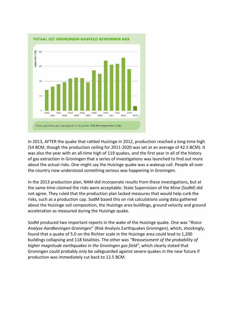
In 2013, AFTER the quake that rattled Huizinge in 2012, production reached a long-time high (54 BCM, though the production ceiling for 2011-2020 was set at an average of 42.5 BCM). It was also the year with an all-time high of 119 quakes, and the first year in all of the history of gas extraction in Groningen that a series of investigations was launched to find out more about the actual risks. One might say the Huizinge quake was a wakeup-call. People all over the country now understood something serious was happening in Groningen. In the 2013 production plan, NAM did incorporate results from these investigations, but at the same time claimed the risks were acceptable. State Supervision of the Mine (SodM) did not agree. They ruled that the production plan lacked measures that would help curb the risks, such as a production cap. SodM based this on risk calculations using data gathered about the Huizinge soil composition, the Huizinge area buildings, ground velocity and ground acceleration as measured during the Huizinge quake. SodM produced two important reports in the wake of the Huizinge quake. One was “Risico Analyse Aardbevingen Groningen” (Risk Analysis Earthquakes Groningen), which, shockingly, found that a quake of 5.0 on the Richter scale in the Huizinge area could lead to 1,200 buildings collapsing and 118 fatalities. The other was “Reassessment of the probability of higher magnitude earthquakes in the Groningen gas field”, which clearly stated that Groningen could probably only be safeguarded against severe quakes in the near future if production was immediately cut back to 12.5 BCM.
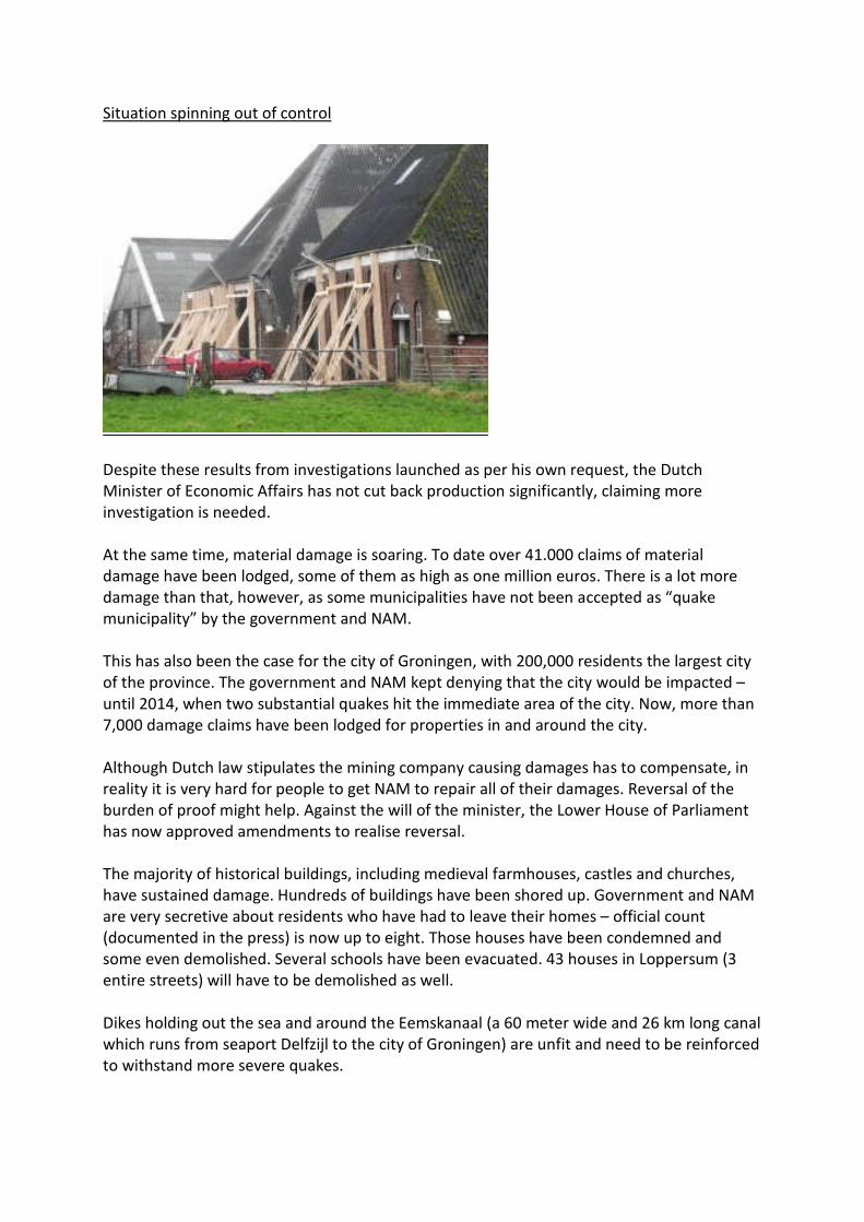
Situation spinning out of control
Despite these results from investigations launched as per his own request, the Dutch Minister of Economic Affairs has not cut back production significantly, claiming more investigation is needed. At the same time, material damage is soaring. To date over 41.000 claims of material damage have been lodged, some of them as high as one million euros. There is a lot more damage than that, however, as some municipalities have not been accepted as “quake municipality” by the government and NAM. This has also been the case for the city of Groningen, with 200,000 residents the largest city of the province. The government and NAM kept denying that the city would be impacted – until 2014, when two substantial quakes hit the immediate area of the city. Now, more than 7,000 damage claims have been lodged for properties in and around the city. Although Dutch law stipulates the mining company causing damages has to compensate, in reality it is very hard for people to get NAM to repair all of their damages. Reversal of the burden of proof might help. Against the will of the minister, the Lower House of Parliament has now approved amendments to realise reversal. The majority of historical buildings, including medieval farmhouses, castles and churches, have sustained damage. Hundreds of buildings have been shored up. Government and NAM are very secretive about residents who have had to leave their homes – official count (documented in the press) is now up to eight. Those houses have been condemned and some even demolished. Several schools have been evacuated. 43 houses in Loppersum (3 entire streets) will have to be demolished as well. Dikes holding out the sea and around the Eemskanaal (a 60 meter wide and 26 km long canal which runs from seaport Delfzijl to the city of Groningen) are unfit and need to be reinforced to withstand more severe quakes.

The housing market has plummeted, meaning that residents cannot sell their houses or escape the region. Consequently, they feel trapped and scared. Based on their own outdated models and current (high) gas extraction rate, which are likely to underestimate the severity of future damage, recently NAM (= Shell and ExxonMobil) reported that until 2023, there is a 50% chance of quakes up to 3.8, a 10% chance of quakes up to 4.6 and a 2% chance of quakes up to 5.1 on the Richter scale. This might cause hundreds of houses to collapse and lead to many (fatal) injuries. Gas extraction resorts under Henk Kamp, Minister of Economic Affairs. He did not heed the advice SodM gave him about drastically cutting back production, but he did put a cap on the Loppersum production cluster, which includes Huizinge and Middelstum. This area bore the brunt of the quakes for years, leading to 3.580 damage claims amongst 10.174 inhabitants. In April 2015, inhabitants took the issue to court. Succesfully: Dutch court ordered NAM to suspend production in Loppersum cluster altogether. However, over the years, production in nearby production cluster East (which includes Delfzijl, host of 15% of the nation’s chemical industry) has been increased. In September 2014, SodM Inspector General Jan de Jong took an early retirement. His replacement is Harry Van der Meijden, a geologist who has worked for Shell for decades (last position: managing director Shell Netherlands). The advices SodM has been giving since this switch are less dramatic, though Mr van der Meijden does admit he cannot guarantee the safety of the inhabitants of the region. Reinforcing more than 170,000 buildings The government is scrambling to get the situation under control. One of the measures Minister Kamp ordered, is reinforcement of houses, churches, offices, shops, hospitals and other buildings. The province of Groningen has put forward that this totals some 170,000 buildings. This will take at least 30 years, and it will cost at least 30 billion euro. How reinforcement should take place, is not clear. Pilot projects incorporate stripping the buildings and shoring them from the inside with heavy duty steel cages to support walls and floors. Though this does guarantee people leaving the building safely after a severe quake, the retrofitted building itself will be a write-off. Interestingly, the Dutch government has not yet implemented a Dutch version of Eurocode 8 (“Design of structures for earthquake resistance”). They have had to improvise, so recently, a draft Code of Practice was published. According to this document, buildings in the region must be reinforced to withstand the following PGA (peak ground acceleration) values:

Public safety ignored from day 1 In 2014, in response to the dramatic turn of events, the Dutch Safety Board launched an investigation into the relationship between public safety and the profit-based strategy of the Dutch government, Shell and ExxonMobil. On February 18th, 2015, they published their report. It concluded that these three parties have seriously and even negligently ignored the safety of the hundreds of thousands of people living on top of the Groningen field. In the English summary, the Dutch Safety Board states: “Forecasts on the expected maximum earthquake intensity are surrounded by numerous uncertainties. When drawing up forecasts, no one knows exactly what mechanisms are at work deep underground, and insufficient research was initiated to examine these factors. The method on which the forecasts are based also has limitations. Until 2013, no integral and independent scientific research had been carried out to obtain greater insight and thereby produce more reliable forecasts. (…) With its passive attitude, NAM failed to fulfil its duty of care. Equally, the Ministry of Economic Affairs, as the guardian of safety interests, should have taken charge back in 1993 and initiated further independent scientific research to reduce the uncertainties surrounding induced earthquakes. Similarly, as the supervisory authority, SodM should have insisted more strongly that this be carried out well before 2012. Knowledge institutions could have indicated the fact that uncertainties were given insufficient consideration in the decision-making process, and the Dutch scientific
community could also have initiated research into gas extraction, independently of NAM and the Ministry of Economic Affairs.” Upon reading the Dutch Safety Board report, the Netherlands Institute for Human Rights stated that human rights in the Groningen region have been violated for decades. The report also discussed the so-called “gasgebouw”: “The ‘Gasgebouw’ (the Dutch Gas Structure) consists of NAM, the Ministry of Economic Affairs, Gasterra, Shell and ExxonMobil. The Dutch Gas Structure is designed to optimise revenues and the guaranteed supply of gas. It is a private, closed and consensus-focused system. Safety interests have not been embedded in this system as a separate interest. The supervisory authority long adhered to this consensus-based approach, partly as a result of which there was insufficient countervailing power to ensure that the existing intervention mechanisms were applied for the purpose of safeguarding safety interests. Under the current system the competent authority itself, the Ministry of Economic Affairs, is a party involved in the exploitation of natural gas and serves as the guardian of all the interests at stake. Other ministries and local and provincial authorities have little or barely any involvement in the gas extraction decision-making process. From an administrative perspective the organised system consequently also offers no room for opposing viewpoints. The combined effect of all this was that safety interests were poorly embedded.” These men, with absolute decision-making power over the volumes of gas to be extracted and sold, rely on a small cadre of scientific advisors, employed by the corporations or the government. For decades, scientists outside of this elite, including eminent foreign geologists, have warned against serious consequences of gas extraction in Groningen, but this small group of internal scientists ignored these views, and sometimes publicly ridiculed them. Even now, after the serious events of the last decade have become common knowledge, scientists not linked in with government, Shell and ExxonMobil are given no voice in the decision-making process. Is gas production still profitable? Though the government has ordered many new studies no move has been made to cut back gas production to the safe level of 12.5 BCM, as advised by SodM in 2013. The reason: big revenues. From 1963 till 2013, the field has yielded the government approx. 265 billion euro. In that same period, NAM has made about 22 billion euro from production. Shell and ExxonMobil also profit from the sales of the gas through GasTerra (25% Shell, 25% ExxonMobil, 50% Dutch government). GasTerra has export contracts with, amongst others, Shell and ExxonMobil in Germany. On average, the government now cashes 10-12 billion euro per year on gas extracted from the Groningen field, while NAM (Shell and ExxonMobil) takes away approx. 1 billion euro per year.

Recently, though, NAM has announced that it is cutting costs because of the lower gas price. This is on top of all the extra costs for material damage claims and reinforcement, which are probably split between NAM and the government in the Maatschap Groningen ratio (60-40). Also, in order to produce the last bit of gas, NAM needs to invest in new compressors, which are very costly. A simple calculation shows that it is unlikely Groningen gas production will ever be profitable again for NAM. Conclusion The Dutch government has invested billions of euros in a ‘gas roundabout’, which consists of a connected junction of gas infrastructure elements for production, transport, storage, transit, trade and knowledge development. Gas production in the Groningen field is limited. In a few years’ time, the Netherlands will import more gas than it produces. There are plans to put extra nitrogen installations on top of the Groningen field to convert high-caloric imported Russian gas to low-caloric quality. And yet, the country does little to develop alternative (sustainable) energy sources. It seems the Dutch government are willing to sacrifice the welfare of an entire region, putting a resident population of up to 450,000 people at risk, rather than kick their gas habit. Nicolette Marié May 2015