
How Can I Quickly Assess Canopy Cover in my … though, we will just be focusing on canopy cover. Go...
10
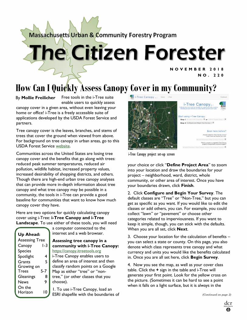
Free tools in the i-Tree suite enable users to quickly assess canopy cover in a given area, without even leaving your home or office! i-Tree is a freely accessible suite of applications developed by the USDA Forest Service and partners. Tree canopy cover is the leaves, branches, and stems of trees that cover the ground when viewed from above. For background on tree canopy in urban areas, go to this USDA Forest Service website. Communities across the United States are losing tree canopy cover and the benefits that go along with trees: reduced peak summer temperatures, reduced air pollution, wildlife habitat, increased property values, increased desirability of shopping districts, and others. Though there are high-end urban tree canopy analyses that can provide more in-depth information about tree canopy and what tree canopy may be possible in a community, the tools in i-Tree can provide a good baseline for communities that want to know how much canopy cover they have. Here are two options for quickly calculating canopy cover using i-Tree: i-Tree Canopy and i-Tree Landscape. To use either of these tools, you will need a computer connected to the internet and a web browser. Assessing tree canopy in a community with i-Tree Canopy: https://canopy.itreetools.org i-Tree Canopy enables users to define an area of interest and then classify random points on a Google Map as either “tree” or “non- tree,” (or other classes that you choose). 1. To use i-Tree Canopy, load an ESRI shapefile with the boundaries of NOVEMBER 2018 NO. 220 How Can I Quickly Assess Canopy Cover in my Community? Up Ahead: Assessing Tree Canopy 1-3 Species Spotlight 4 Grants 5 Growing on Trees 5-7 Gleanings 8 News 9 On the Horizon 10 your choice or click “Define Project Area” to zoom into your location and draw the boundaries for your project – neighborhood, ward, district, whole community, or other area of interest. Once you have your boundaries drawn, click Finish. 2. Click Configure and Begin Your Survey. The default classes are “Tree” or “Non-Tree,” but you can get as specific as you want. If you would like to edit the classes or add others, you can. For example, you could collect “lawn” or “pavement” or choose other categories related to imperviousness. If you want to keep it simple, though, you can stick with the defaults. When you are all set, click Next. 3. Choose your location for the calculation of benefits – you can select a state or county. On this page, you also denote which class represents tree canopy and what currency and units you would like the benefits calculated in. Once you are all set here, click Begin Survey. 4. Now you see the map, as well as your cover class table. Click the + sign in the table and i-Tree will generate your first point. Look for the yellow cross on the picture. (Sometimes it can be hard to see a point when it falls on a light surface, but it is always in the (Continued on page 2) By Mollie Freilicher i-Tree Canopy project set-up screen
Transcript of How Can I Quickly Assess Canopy Cover in my … though, we will just be focusing on canopy cover. Go...
Free tools in the i-Tree suite
enable users to quickly assess
canopy cover in a given area, without even leaving your
home or office! i-Tree is a freely accessible suite of
applications developed by the USDA Forest Service and
partners.
Tree canopy cover is the leaves, branches, and stems of
trees that cover the ground when viewed from above.
For background on tree canopy in urban areas, go to this
USDA Forest Service website.
Communities across the United States are losing tree
canopy cover and the benefits that go along with trees:
reduced peak summer temperatures, reduced air
pollution, wildlife habitat, increased property values,
increased desirability of shopping districts, and others.
Though there are high-end urban tree canopy analyses
that can provide more in-depth information about tree
canopy and what tree canopy may be possible in a
community, the tools in i-Tree can provide a good
baseline for communities that want to know how much
canopy cover they have.
Here are two options for quickly calculating canopy
cover using i-Tree: i-Tree Canopy and i-Tree
Landscape. To use either of these tools, you will need
a computer connected to the
internet and a web browser.
Assessing tree canopy in a
community with i-Tree Canopy: https://canopy.itreetools.org
i-Tree Canopy enables users to
define an area of interest and then
classify random points on a Google
Map as either “tree” or “non-
tree,” (or other classes that you
choose).
1. To use i-Tree Canopy, load an
ESRI shapefile with the boundaries of
N O V E M B E R 2 0 1 8
N O . 2 2 0
How Can I Quickly Assess Canopy Cover in my Community?
Up Ahead:
Assessing Tree
Canopy 1-3
Species
Spotlight 4
Grants 5 Growing on Trees 5-7
Gleanings 8
News 9
On the Horizon 10
your choice or click “Define Project Area” to zoom
into your location and draw the boundaries for your
project – neighborhood, ward, district, whole
community, or other area of interest. Once you have
your boundaries drawn, click Finish.
2. Click Configure and Begin Your Survey. The
default classes are “Tree” or “Non-Tree,” but you can
get as specific as you want. If you would like to edit the
classes or add others, you can. For example, you could
collect “lawn” or “pavement” or choose other
categories related to imperviousness. If you want to
keep it simple, though, you can stick with the defaults.
When you are all set, click Next.
3. Choose your location for the calculation of benefits –
you can select a state or county. On this page, you also
denote which class represents tree canopy and what
currency and units you would like the benefits calculated
in. Once you are all set here, click Begin Survey.
4. Now you see the map, as well as your cover class
table. Click the + sign in the table and i-Tree will
generate your first point. Look for the yellow cross on
the picture. (Sometimes it can be hard to see a point
when it falls on a light surface, but it is always in the
(Continued on page 2)
By Mollie Freilicher
i-Tree Canopy project set-up screen
P A G E 2
d e p a r t m e n t o f C o n s e r v a t i o n a n d R ec r e a t i o n
N O V E M B E R 2 0 1 8
How Can I Quickly Assess Canopy Cover in my Community?
T H E C I T I Z E N F O R E S T E R
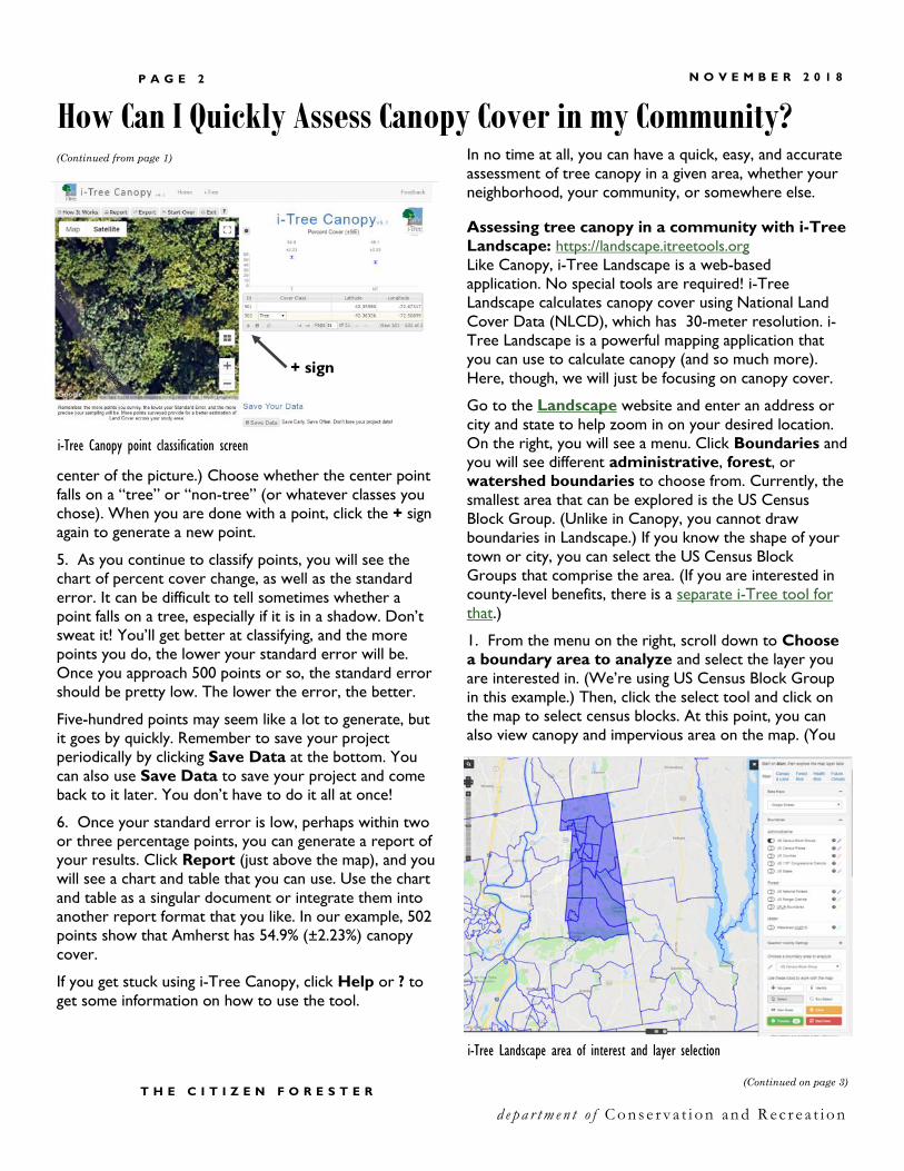
center of the picture.) Choose whether the center point
falls on a “tree” or “non-tree” (or whatever classes you
chose). When you are done with a point, click the + sign
again to generate a new point.
5. As you continue to classify points, you will see the
chart of percent cover change, as well as the standard
error. It can be difficult to tell sometimes whether a
point falls on a tree, especially if it is in a shadow. Don’t
sweat it! You’ll get better at classifying, and the more
points you do, the lower your standard error will be.
Once you approach 500 points or so, the standard error
should be pretty low. The lower the error, the better.
Five-hundred points may seem like a lot to generate, but
it goes by quickly. Remember to save your project
periodically by clicking Save Data at the bottom. You
can also use Save Data to save your project and come
back to it later. You don’t have to do it all at once!
6. Once your standard error is low, perhaps within two
or three percentage points, you can generate a report of
your results. Click Report (just above the map), and you
will see a chart and table that you can use. Use the chart
and table as a singular document or integrate them into
another report format that you like. In our example, 502
points show that Amherst has 54.9% (±2.23%) canopy
cover.
If you get stuck using i-Tree Canopy, click Help or ? to
get some information on how to use the tool.
(Continued from page 1) In no time at all, you can have a quick, easy, and accurate
assessment of tree canopy in a given area, whether your
neighborhood, your community, or somewhere else.
Assessing tree canopy in a community with i-Tree
Landscape: https://landscape.itreetools.org
Like Canopy, i-Tree Landscape is a web-based
application. No special tools are required! i-Tree
Landscape calculates canopy cover using National Land
Cover Data (NLCD), which has 30-meter resolution. i-
Tree Landscape is a powerful mapping application that
you can use to calculate canopy (and so much more).
Here, though, we will just be focusing on canopy cover.
Go to the Landscape website and enter an address or
city and state to help zoom in on your desired location.
On the right, you will see a menu. Click Boundaries and
you will see different administrative, forest, or
watershed boundaries to choose from. Currently, the
smallest area that can be explored is the US Census
Block Group. (Unlike in Canopy, you cannot draw
boundaries in Landscape.) If you know the shape of your
town or city, you can select the US Census Block
Groups that comprise the area. (If you are interested in
county-level benefits, there is a separate i-Tree tool for
that.)
1. From the menu on the right, scroll down to Choose
a boundary area to analyze and select the layer you
are interested in. (We’re using US Census Block Group
in this example.) Then, click the select tool and click on
the map to select census blocks. At this point, you can
also view canopy and impervious area on the map. (You
(Continued on page 3)
+ sign
i-Tree Canopy point classification screen
i-Tree Landscape area of interest and layer selection

T H E C I T I Z E N F O R E S T E R
d e p a r t m e n t o f C o n s e r v a t i o n a n d R ec r e a t i o n
P A G E 3 N O V E M B E R 2 0 1 8
can also make the shading of your selection more
transparent, so that it’s easier to see canopy
underneath.) Click Selection Visibility Settings and
move the slider to adjust transparency.
2. To view canopy, as well as other features, click on the
tabs “Canopy & Land,” “Forest Risk,” “Health
Risk,” or “Future Climate.” Note that some of these
maps may be more suited to projects looking at state-
level or regional scales – the scale may not be fine
(Continued from page 2)
enough to detect possible differences within a
municipality or county. To view canopy, click Canopy &
Land and then move the sliders below to view Tree
Canopy, Plantable Space, Total Basal Area, or
Forest Type. In Other Land Cover, you can also
view impervious area.
3. To view tree canopy on the map, click the button by
Tree Canopy. You can zoom in and out of the map and
get a sense for canopy in the area. (You can also explore
the other map visualizations, too.)
4. To calculate canopy, click the Main tab and then
scroll down to Process. This will crunch canopy and
other data for the area or areas you selected. Now, at
the bottom of the window, there is a table with tabular
data from the US Census and the map layers. For our
example here, we see canopy is 53.54%. (Our figure in
Canopy was 54.9 ± 2.23, so these definitely comport!) In
the table, you will also notice a figure for impervious
surface and plantable space. If all you are interested in is
calculating Canopy, congratulations! You’re done!
There is much, much more to Landscape - from looking
at census data, forest risk, health risk, and future climate,
as well as prioritizing planting based on census data. For
more information on Landscape, go to: http://
www.itreetools.org/landscape/index.php
For more information on Canopy, Landscape, and other i
-Tree tools, go to www.itreetools.org. You can even
watch videos to help you get projects started.
Tree City, Tree Line, and Tree Campus USA Applications Due December 31
We are accepting applications for Tree City, Tree Line, and Tree Campus USA. Complete instructions are
on the DCR website. If your community , utility, or school does not currently participate in these programs,
contact Mollie Freilicher, [email protected] or 413-577-2966 to find out more and how you can
apply next year.
How Can I Quickly Assess Canopy Cover in my Community?
i-Tree Landscape tree canopy cover visualization with transparency adjusted for the area of interest and the tree canopy layer
P A G E 4
d e p a r t m e n t o f C o n s e r v a t i o n a n d R ec r e a t i o n
T H E C I T I Z E N F O R E S T E R
N O V E M B E R 2 0 1 8
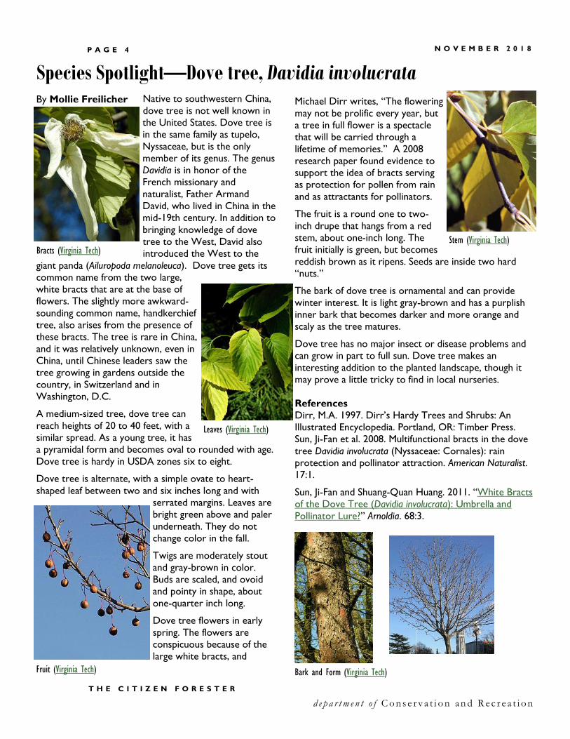
Species Spotlight—Dove tree, Davidia involucrata Native to southwestern China,
dove tree is not well known in
the United States. Dove tree is
in the same family as tupelo,
Nyssaceae, but is the only
member of its genus. The genus
Davidia is in honor of the
French missionary and
naturalist, Father Armand
David, who lived in China in the
mid-19th century. In addition to
bringing knowledge of dove
tree to the West, David also
introduced the West to the
giant panda (Ailuropoda melanoleuca). Dove tree gets its
common name from the two large,
white bracts that are at the base of
flowers. The slightly more awkward-
sounding common name, handkerchief
tree, also arises from the presence of
these bracts. The tree is rare in China,
and it was relatively unknown, even in
China, until Chinese leaders saw the
tree growing in gardens outside the
country, in Switzerland and in
Washington, D.C.
A medium-sized tree, dove tree can
reach heights of 20 to 40 feet, with a
similar spread. As a young tree, it has
a pyramidal form and becomes oval to rounded with age.
Dove tree is hardy in USDA zones six to eight.
Dove tree is alternate, with a simple ovate to heart-
shaped leaf between two and six inches long and with
serrated margins. Leaves are
bright green above and paler
underneath. They do not
change color in the fall.
Twigs are moderately stout
and gray-brown in color.
Buds are scaled, and ovoid
and pointy in shape, about
one-quarter inch long.
Dove tree flowers in early
spring. The flowers are
conspicuous because of the
large white bracts, and
By Mollie Freilicher Michael Dirr writes, “The flowering
may not be prolific every year, but
a tree in full flower is a spectacle
that will be carried through a
lifetime of memories.” A 2008
research paper found evidence to
support the idea of bracts serving
as protection for pollen from rain
and as attractants for pollinators.
The fruit is a round one to two-
inch drupe that hangs from a red
stem, about one-inch long. The
fruit initially is green, but becomes
reddish brown as it ripens. Seeds are inside two hard
“nuts.”
The bark of dove tree is ornamental and can provide
winter interest. It is light gray-brown and has a purplish
inner bark that becomes darker and more orange and
scaly as the tree matures.
Dove tree has no major insect or disease problems and
can grow in part to full sun. Dove tree makes an
interesting addition to the planted landscape, though it
may prove a little tricky to find in local nurseries.
References
Dirr, M.A. 1997. Dirr’s Hardy Trees and Shrubs: An
Illustrated Encyclopedia. Portland, OR: Timber Press.
Sun, Ji-Fan et al. 2008. Multifunctional bracts in the dove
tree Davidia involucrata (Nyssaceae: Cornales): rain
protection and pollinator attraction. American Naturalist.
17:1.
Sun, Ji-Fan and Shuang-Quan Huang. 2011. “White Bracts
of the Dove Tree (Davidia involucrata): Umbrella and
Pollinator Lure?” Arnoldia. 68:3.
Bracts (Virginia Tech)
Leaves (Virginia Tech)
Stem (Virginia Tech)
Fruit (Virginia Tech) Bark and Form (Virginia Tech)
P A G E 5 N O V E M B E R 2 0 1 8
T H E C I T I Z E N F O R E S T E R
d e p a r t m e n t o f C o n s e r v a t i o n a n d R ec r e a t i o n
Growing on Trees Fifth grade classes from
schools across Massachusetts
are encouraged to participate
in the annual Arbor Day
Poster Contest by having fifth-
grade students create posters
highlighting this year’s theme
and then hosting a school
poster contest. The winning
poster from each school can
be submitted to DCR. Home-
schooled or non-participating
school students may submit
their posters and enter the
contest individually.
The Arbor Day Poster Contest is sponsored by the Department of Conservation and
Recreation, the U.S. Forest Service, and the Massachusetts Tree Wardens’ and Foresters’ Association.
For complete rules and
guidelines, go to the Arbor
Day Poster Contest page on
the DCR website.
Drought Monitor With the recent rains, as of October 30, 2018, and for
the first time in a while, no areas of Massachusetts are
in drought status or classified as abnormally dry. Find
out more at the US National Drought Monitor.
Tree Wardens, Highway Supervisors, and other Municipal Staff learn about
managing roadside tree mortality at a recent workshop sponsored by National
Grid, DCR, and the Mass. Tree Wardens’ and Foresters’ Association in Hopedale.
(Above – Mollie Freilicher DCR Urban and Community Forestry; Below—Nicole
Keleher, DCR Forest Health)
P A G E 6
d e p a r t m e n t o f C o n s e r v a t i o n a n d R ec r e a t i o n
T H E C I T I Z E N F O R E S T E R
N O V E M B E R 2 0 1 8
Growing on Trees
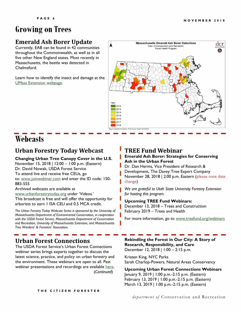
Emerald Ash Borer Update Currently, EAB can be found in 42 communities
throughout the Commonwealth, as well as in all
five other New England states. Most recently in
Massachusetts, the beetle was detected in
Chelmsford.
Learn how to identify the insect and damage at the
UMass Extension webpage.
Urban Forestry Today Webcast
Changing Urban Tree Canopy Cover in the U.S.
November 15, 2018 | 12:00 – 1:00 p.m. (Eastern)
Dr. David Nowak, USDA Forest Service
To attend live and receive free CEUs, go
to: www.joinwebinar.com and enter the ID code: 150-
883-555
Archived webcasts are available at
www.urbanforestrytoday.org under ‘Videos.’
This broadcast is free and will offer the opportunity for
arborists to earn 1 ISA CEU and 0.5 MCA credit.
The Urban Forestry Today Webcast Series is sponsored by the University of
Massachusetts Department of Environmental Conservation, in cooperation
with the USDA Forest Service, Massachusetts Department of Conservation
and Recreation, University of Massachusetts Extension, and Massachusetts
Tree Wardens' & Foresters' Association.
TREE Fund Webinar Emerald Ash Borer: Strategies for Conserving
Ash in the Urban Forest
Dr. Dan Herms, Vice President of Research &
Development, The Davey Tree Expert Company
November 28, 2018 | 2:00 p.m. Eastern (please note date
change)
We are grateful to Utah State University Forestry Extension
for hosting this program.
Upcoming TREE Fund Webinars:
December 13, 2018 – Trees and Construction
February 2019 – Trees and Health
For more information, go to www.treefund.org/webinars
Urban Forest Connections The USDA Forest Service’s Urban Forest Connections
webinar series brings experts together to discuss the
latest science, practice, and policy on urban forestry and
the environment. These webinars are open to all. Past
webinar presentations and recordings are available here.
(Continued)
Webcasts
Rekindling the Forest in Our City: A Story of
Research, Responsibility, and Care
December 12, 2018 | 1:00 – 2:15 p.m.
Kristen King, NYC Parks
Sarah Charlop-Powers, Natural Areas Conservancy
Upcoming Urban Forest Connections Webinars
January 9, 2019 | 1:00 p.m.-2:15 p.m. (Eastern)
February 13, 2019 | 1:00 p.m.-2:15 p.m. (Eastern)
March 13, 2019 | 1:00 p.m.-2:15 p.m. (Eastern)
Growing on Trees
P A G E 7 N O V E M B E R 2 0 1 8
T H E C I T I Z E N F O R E S T E R
d e p a r t m e n t o f C o n s e r v a t i o n a n d R ec r e a t i o n
UMass– Amherst—Tree Inventories Dear Colleagues, - We (researchers at UMass -
Amherst) are conducting a study on commonalities
between street trees planted in municipalities around the
globe. Please help us by completing a short, ~3 minute
survey on tree inventory data collected by your city or
municipality.
Thanks for your time!
Sincerely,
Bethany Bradley, Associate Professor of Biogeography,
Brian Kane, Mass. Arborists Association Professor
UMass–Amherst
Municipal Forestry Institute 2019 – Registration Now Open Registration is now open for the 2019 session of the Municipal Forestry Institute (MFI), to be held in Silverton, Oregon,
February 24-March 1. MFI is an intensive five-day program for urban foresters, hosted by the Society of Municipal
Arborists. It is not your typical training for arborists and urban foresters. The focus of the MFI curriculum is leadership
and how to move your urban forestry program from good to great. Thinking about attending in the future? Use a DCR
Urban and Community Forestry Challenge Grant to help defray the cost. Find out more. https://www.urban-
forestry.com.
New England ISA Annual Conference November 4-6, 2018 | Mystic, CT
Please join us for the New England Chapter International Society of Arboriculture Annual Conference and Tradeshow
where we will "Honor the Past, Treasure the Present, Shape the Future" in beautiful Mystic, Connecticut. Dr. John Ball
will be this year's keynote speaker. There are many pre-conference events, starting Saturday November 3. Enjoy all
that Mystic has to offer. Come for the weekend! Earn CEUs and pesticide credits. Find out more at newenglandisa.org.
Upcoming Courses For complete listings and the most up-to-date
information, please go to the provider’s website.
Arnold Arboretum
www.arboretum.harvard.edu/education/adult-education
Measure Twice, Cut Once: Introductory Tree and Shrub
Pruning – December 8
Winter Tree Identification – February 9
Berkshire Botanic Garden
www.berkshirebotanical.org
Plant Health Care – Nov. 27, 2018 – Dec. 18, 2018
Bark and Buds: Winter Tree ID – December 8
Tree Care for Gardeners – February 1-15, 2019
Orchard Management –March 23, 2019
New England Wildflower Society
http://www.newenglandwild.org/learn/our-programs
Winter Branchlet Identification – November 1
An Autumn Walk through Meadow and Forest –
November 2
Naked Shrubs – November 10
Wetland Shrubs in Winter – January 19
Fruits and Seeds Revealed – January 20
Winter Botany – January 31
Understanding and Managing Soils – February 9
Climate Change and the Plants of New England –
February 12
Winter Pruning – March 12
Polly Hill Arboretum
www.pollyhillarboretum.org/education
Fall Guided Walk – November 17
Univ. of British Columbia—Species Selection Consider participating in our Urban Tree Selection Study
regarding the priorities for tree species selection in cities
across temperate North America.
Study team: This research is being conducted by graduate
student Jehane Samaha and her supervisor Dr. Cecil
Konijnendijk van den Bosch, through the University of
British Columbia (UBC), Department of Forest
Resources Management. If you have questions about this
research in general, or about your role in the study,
please feel free to contact either member of the study
team using the e-mails listed below.
The survey is available at this link:
http://tinyurl.com/urbantreeselection Thank you!
Researchers Are Looking for Input
P A G E 8 N O V E M B E R 2 0 1 8
d e p a r t m e n t o f C o n s e r v a t i o n a n d R ec r e a t i o n
T H E C I T I Z E N F O R E S T E R
Planting Trees with Greater Purpose: The time is now By Dan Lambe, President of the Arbor Day Foundation
October 19, 2018 – With all the global issues we face today — including poor air and water quality, climate risk,
deforestation, poverty, and hunger — individuals and organizations alike are taking a proactive step to become part of
the solution. And they are turning to trees to make a difference. There is a natural draw to tree planting and forests
because there is an emotional and intuitive connection between trees and a healthier planet.
Planting trees is a simple yet serious strategy to combating the biggest challenges facing the world today. Because trees
provide the necessities of life itself — and the beneficiaries of trees are people. They filter pollutants out of the air and
water while protecting us from dangerous heat and flooding. They lower urban temperatures, reduce energy use and
sequester carbon to slow the rate of climate change. Resources from forests help to keep people out of extreme
poverty. Green environments encourage physical activity, improve cognitive ability and reduce stress. And trees foster
community engagement and connectivity in a unique and positive way.
For these benefits and more, there’s a great urgency to plant trees and restore forests. That’s why, every year, working
with our government, corporate and non-governmental partners, our foundation helps to plant millions of trees
throughout the U.S. and around the world. These efforts are happening strategically in National Forests, rain forests
and the cities and towns that make up our urban forest. Read the rest of Dan Lambe’s commentary at The Denver Post.
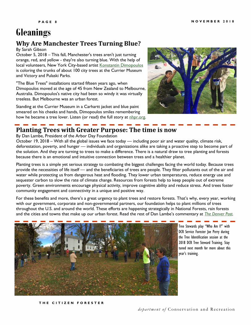
Why Are Manchester Trees Turning Blue? By Sarah Gibson
October 5, 2018 – This fall, Manchester's trees aren't just turning
orange, red, and yellow - they're also turning blue. With the help of
local volunteers, New York City-based artist Konstantin Dimopoulos
is coloring the trunks of about 100 city trees at the Currier Museum
and Victory and Pulaski Parks.
"The Blue Trees" installations started fifteen years ago, when
Dimopoulos moved at the age of 45 from New Zealand to Melbourne,
Australia. Dimopoulos's native city had been so windy it was virtually
treeless. But Melbourne was an urban forest.
Standing at the Currier Museum in a Carhartt jacket and blue paint
smeared on his cheeks and hands, Dimopoulos smiles remembering
how he became a tree lover. Listen (or read) the full story at nhpr.org.
Gleanings
Tree Stewards play “Who Am I?” with
DCR Service Forester Joe Perry during
the Tree Identification session at the
2018 DCR Tree Steward Training. Stay
tuned next month for more about this
year’s training.
P A G E 9 N O V E M B E R 2 0 1 8
Millions of Connecticut Trees Have Been Killed or Damaged in Recent Years. Taking Them Down is Expensive.
More Trees, Happier People
Climate Change, Pests, Fallen Trees a Deadly Recipe for US Forests
Chicago Group Gets $1M to Plant Trees, Combat Climate Change
PG&E Cutting Trees near Power Lines in High Fire-Risk Areas – California
TD Bank and ReGreen Springfield Join Forces to Plant Trees for Better Air Quality
T H E C I T I Z E N F O R E S T E R d e p a r t m e n t o f C o n s e r v a t i o n a n d R ec r e a t i o n
News
News Headlines in Brief
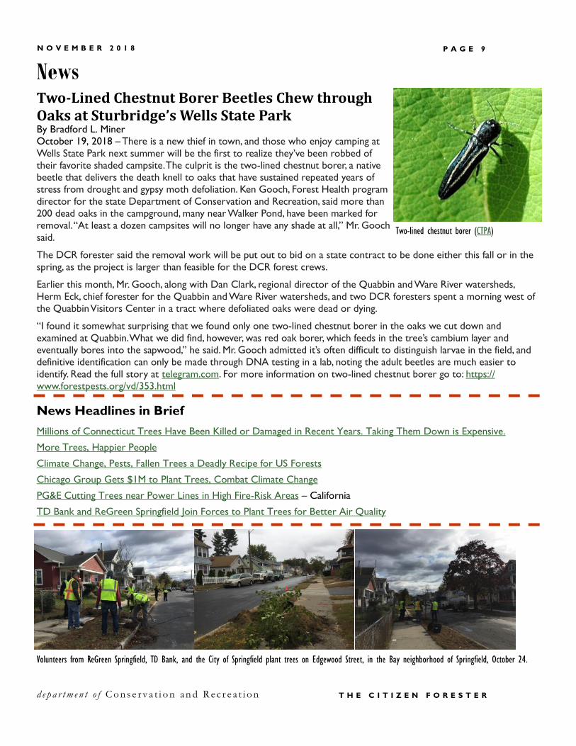
Two-Lined Chestnut Borer Beetles Chew through Oaks at Sturbridge’s Wells State Park By Bradford L. Miner
October 19, 2018 – There is a new thief in town, and those who enjoy camping at
Wells State Park next summer will be the first to realize they’ve been robbed of
their favorite shaded campsite. The culprit is the two-lined chestnut borer, a native
beetle that delivers the death knell to oaks that have sustained repeated years of
stress from drought and gypsy moth defoliation. Ken Gooch, Forest Health program
director for the state Department of Conservation and Recreation, said more than
200 dead oaks in the campground, many near Walker Pond, have been marked for
removal. “At least a dozen campsites will no longer have any shade at all,” Mr. Gooch
said.
The DCR forester said the removal work will be put out to bid on a state contract to be done either this fall or in the
spring, as the project is larger than feasible for the DCR forest crews.
Earlier this month, Mr. Gooch, along with Dan Clark, regional director of the Quabbin and Ware River watersheds,
Herm Eck, chief forester for the Quabbin and Ware River watersheds, and two DCR foresters spent a morning west of
the Quabbin Visitors Center in a tract where defoliated oaks were dead or dying.
“I found it somewhat surprising that we found only one two-lined chestnut borer in the oaks we cut down and
examined at Quabbin. What we did find, however, was red oak borer, which feeds in the tree’s cambium layer and
eventually bores into the sapwood,” he said. Mr. Gooch admitted it’s often difficult to distinguish larvae in the field, and
definitive identification can only be made through DNA testing in a lab, noting the adult beetles are much easier to
identify. Read the full story at telegram.com. For more information on two-lined chestnut borer go to: https://
www.forestpests.org/vd/353.html
Two-lined chestnut borer (CTPA)
Volunteers from ReGreen Springfield, TD Bank, and the City of Springfield plant trees on Edgewood Street, in the Bay neighborhood of Springfield, October 24.

Julie Coop, Urban and Community Forester [email protected], 617-626-1468
Mollie Freilicher, Community Action Forester [email protected], (413) 577-2966
www.mass.gov/dcr/urban-and-community-forestry
The Citizen Forester is made possible through a grant from the USDA Forest Service Urban and
Community Forestry Program and the Massachusetts Department of Conservation and Recreation,
Bureau of Forestry.
On the Horizon
Charles D. Baker, Governor
Karyn E. Polito, Lieutenant Governor
Matthew A. Beaton, Secretary, Executive Office of Energy and Environmental Affairs
Leo Roy, Commissioner, Department of Conservation and Recreation
Peter Church, Director of Forest Stewardship, Department of Conservation and Recreation
Bureau of Forestry Department of Conservation and Recreation 251 Causeway Street, Suite 600 Boston, MA 02114
If you have a topic you’d like to see covered or
want to submit an item to The Citizen Forester
(article, photo, event listing, etc.),
contact Mollie Freilicher or click here.
Subscribe? Unsubscribe? You are receiving this because
you have requested to receive The Citizen Forester. If this is an
error or you do not wish to receive this newsletter, please
email [email protected]. To sign up, click here.
The Department of Conservation and Recreation prohibits discrimination in employment on the basis of race, color, creed, religion,
national origin, ethnicity, gender, gender identity or expression, age, sexual orientation, Vietnam Era Veteran status, or disability.
Dec 13 TREE Fund Webinar, Trees and Construction,
2:00 p.m. (Eastern),
www.treefund.org/webinars
Dec 31 Tree City, Tree Line, and Tree Campus USA
Applications Due, contact
[email protected] | 413-577-296
Jan 8-9 Mass. Tree Wardens and Foresters
Association Annual Conference, Sturbridge,
www.masstreewardens.org
Feb 24- Municipal Forestry Institute,
Mar 1 Silverton, OR, www.urban-forestry.com
Mar 5 Community Tree Conference,
UMass-Amherst
Mar 12 Western Mass. Tree Wardens’ Dinner Meeting,
Northampton
Nov 4-6 New England ISA Annual Conference,
Mystic, CT, www.newenglandisa.org
Nov 6-7 Society of Municipal Arborists
Annual Conference, Irvine, CA,
www.urban-forestry.com
Nov 7-8 Partners in Community Forestry Conference,
Irvine, CA, www.arborday.org/programs/pcf/
Nov 8-10 TCIA Expo, Charlotte, NC, www.tcia.org
Nov 27 MAA Annual Meeting, Framingham,
https://massarbor.org/
Nov 28 ISA Exam, Wellesley, www.newenglandisa.org
(Must be enrolled in exam by November 8)
Nov 28 TREE Fund Webinar, Emerald Ash Borer,
2:00 p.m. (Eastern),
www.treefund.org/webinars
Nov 28- ASCA Annual Conference,
Dec 1 San Diego, CA, www.asca-consultants.org


