How Africa is feeding Europe - Greenpeace USA · How Africa is feeding Europe 3 Summary One of the...
16
greenpeace.org Defending Our Oceans How Africa is feeding Europe EU (over)fishing in West Africa Expedition Report West Africa Ship Tour March 2010
Transcript of How Africa is feeding Europe - Greenpeace USA · How Africa is feeding Europe 3 Summary One of the...

greenpeace.org Def
end
ing
Our
Oce
ans
How Africa is feeding EuropeEU (over)fishing in West Africa
Expedition Report West Africa Ship Tour March 2010
01 Summary 03
02 Europe’s largest and most powerful vessels 07
03 The problem 12
04 The way forward 13
Full list of vessels 14
References 16
For more information contact:[email protected]
Written by:Farah Obaidullah & Yvette Osinga
Edited by:Steve Erwood, Steve Smith, Lara Teunissen
Designed by:Atomo Design
Acknowledgements:Saskia Richartz; the crew of the Arctic Sunrise
Cover photograph:Catch from the Senegalese bottom trawler Nikolaos K, fishing in Gambian waters© Greenpeace / Christian Åslund
September 2010
JN 351
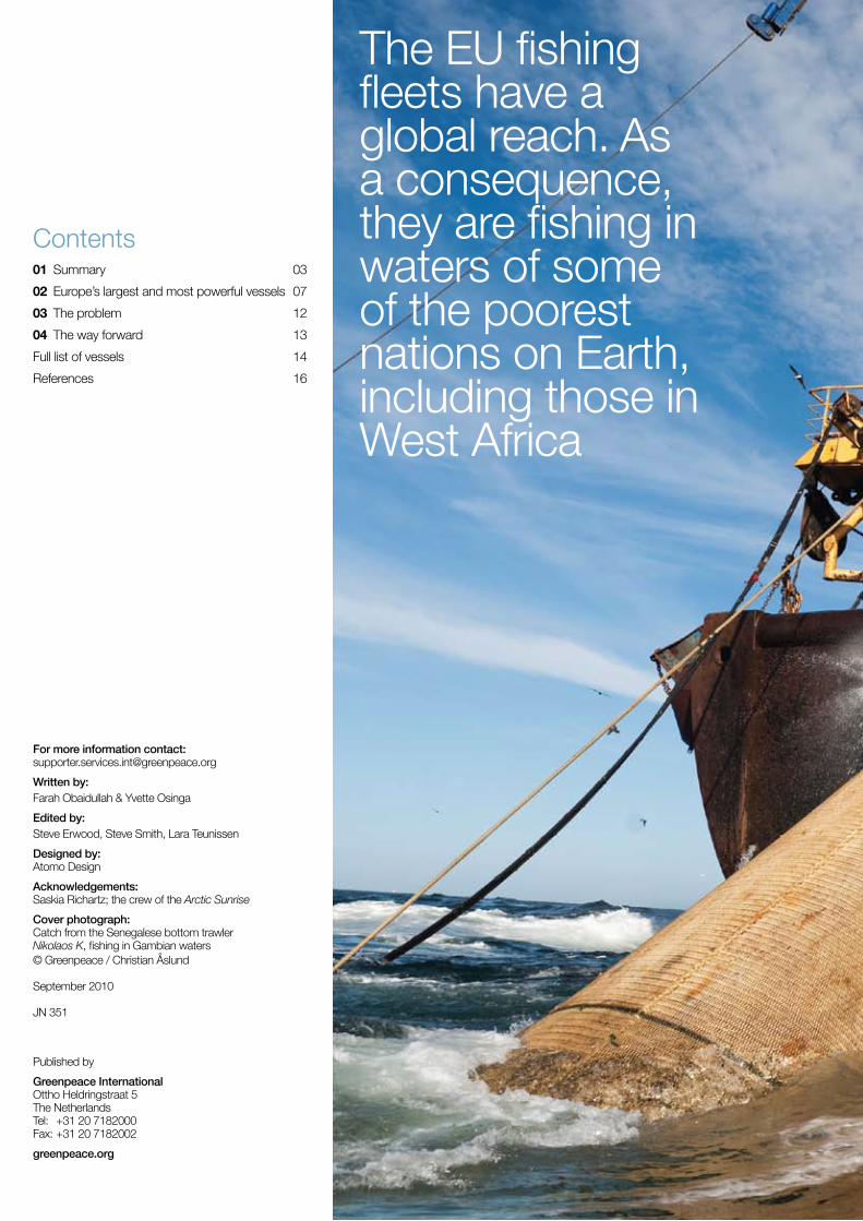
Contents
Published by
Greenpeace InternationalOttho Heldringstraat 5The NetherlandsTel: +31 20 7182000Fax: +31 20 7182002
greenpeace.org
The EU fishing fleets have a global reach. As a consequence, they are fishing in waters of some of the poorest nations on Earth, including those in West Africa

How Africa is feeding Europe 3
SummaryOne of the biggest threats facing the world’s oceans today is overfishing. The UN Food & Agriculture Organisation (FAO) estimates that over 75% of all fish stocks are fully exploited, overexploited or depleted. In European waters, the level of overfishing is higher than the global average, with an estimated 88% of European fish stocks in a poor state. For some stocks, particularly predatory fish such as sharks, tuna and swordfish, the situation is even more alarming across all oceans, with declines of 90% compared with pre-industrial times.
Currently, the EU fleet is capable of catching between two and three times its maximum sustainable yield. Despite attempts to cut the size of fishing fleets and reduce pressure on fish stocks, the EU has increased the effective catch capacity in many of its fisheries by an estimated 2 to 4% a year. This increase in pressure on marine resources, coupled with declines in fish stocks across Europe, has meant that EU fishing vessels have moved to distant fishing grounds. Today, the EU’s fishing fleets have a global reach. As a consequence, they are also fishing in waters of some of the poorest nations on Earth, including in West Africa.
Image The 120 metre pelagic trawler Johanna Maria, owned
by Dutch company Jaczon and sailing under an Irish flag. The
vessel is fishing for round sardinella (Sardinella aurita) under an EU
fisheries partnership agreement © G
RE
EN
PE
AC
E /
CH
RIS
TIA
N Å
SLU
ND
01

4 How Africa is feeding Europe
01 Summary
Main findingsThe observations made during the five weeks represent a snapshot of the activities of vessels operating in the region. Of the 130 vessels encountered by Greenpeace, 93 were identified as foreign-flagged vessels and 29 were trawlers flagged to either Mauritania or Senegal (the flag was unknown for the remaining eight vessels). As the small local artisanal canoes (also known locally as pirogues) were often hard to identify, these have not all been documented and are therefore not included in the total count of encountered fishing vessels. Canoes or pirogues were spotted fishing as far as 18, 25 and 40 nautical miles offshore. In total, 61 vessels were owned by companies from EU countries.
Roughly three main groups of fishing vessels can be distinguished:
1 bottom trawlers with an average length of 33 metres and tonnage of 329 GT. These were mostly Spanish-flagged vessels, while some were local;
2 pelagic factory freezer trawlers, with an average length of 110 metres and tonnage of 5,476 GT. These vessels originate from countries of the former Soviet Union, Iceland and the Netherlands; and
3 artisanal open fishing boats/canoes, varying in size, fishing with nets, pots and/or lines. Several Senegalese canoes were also documented in Mauritania that, according to testimonies, were forced to fish so far from home due to the poor state of fish stocks in Senegal.
The EU currently has so-called Fisheries Partnership Agreements (FPAs) with seven West African countries: Cape Verde, Ivory Coast, Gabon, Guinea, Guinea-Bissau, Mauritania and Sao Tome e Principe. Until 2006, the EU also had an FPA with Senegal, but this was discontinued as Senegal’s own fisheries capacity had grown over time and its stocks declined.
While the EU claims that FPAs help to ensure transparency of fishing activities in the area, EU-based fishing companies are engaged in a number of private ventures in West Africa that do not fall under the auspices of the EU’s Common Fisheries Policy (CFP). These private fishing arrangements are not generally considered part of the EU footprint in West Africa and are therefore not registered in the statistics. This is despite the fact that this type of fishing benefits EU-registered companies and often serves the EU market.
Greenpeace has been documenting fishing activities in West Africa for many years. In both 2001 and 2006 Greenpeace sent a ship to the region, to witness the plunder of West African waters by vessels fishing illegally or in an unregulated or unreported (IUU) fashion. On both occasions Greenpeace investigated and published data1, 2 on how illegal fish from West African waters was finding its way to EU ports and markets.
While efforts are slowly being made to curb IUU fishing, which is thought to account for annual losses of $1 billion US dollars in the fisheries of sub-Saharan Africa alone, little has actually been done to address the even bigger problem of overfishing in the region.
For a period of five weeks between 24 February and 1 April 2010, the Greenpeace ship Arctic Sunrise sailed the waters of Mauritania and Senegal in an attempt to understand the scale and type of foreign fishing in the region. During this period, Greenpeace documented 126 fishing vessels (excluding canoes / pirogues) and 4 reefers (a refrigerated ship normally used for transporting fish). Of the 93 foreign vessels that have been documented, 61 were from the EU. In addition, Greenpeace documented 26 Mauritanian and Senegalese trawlers, and encountered several dozen local canoes / pirogues.
This Expedition Report provides a basic overview of the type of vessels encountered during the expedition, highlighting some of the problems of overfishing through specific examples.
Method of data collectionThe initial navigation route of the Arctic Sunrise was guided by two days of aerial surveillance. The Greenpeace ship first sailed to the Northern border of Mauritania, and subsequently followed a regular search pattern south to Dakar, Senegal. From Dakar the ship continued south, to the southern border of Senegal, and then back up to Mauritania.
Image Pirogue Fishing Boats in Dakar
© G
RE
EN
PE
AC
E /
CH
RIS
TIA
N Å
SLU
ND
Summary 01
5How Africa is feeding Europe
© G
RE
EN
PE
AC
E /
CH
RIS
TIA
N Å
SLU
ND
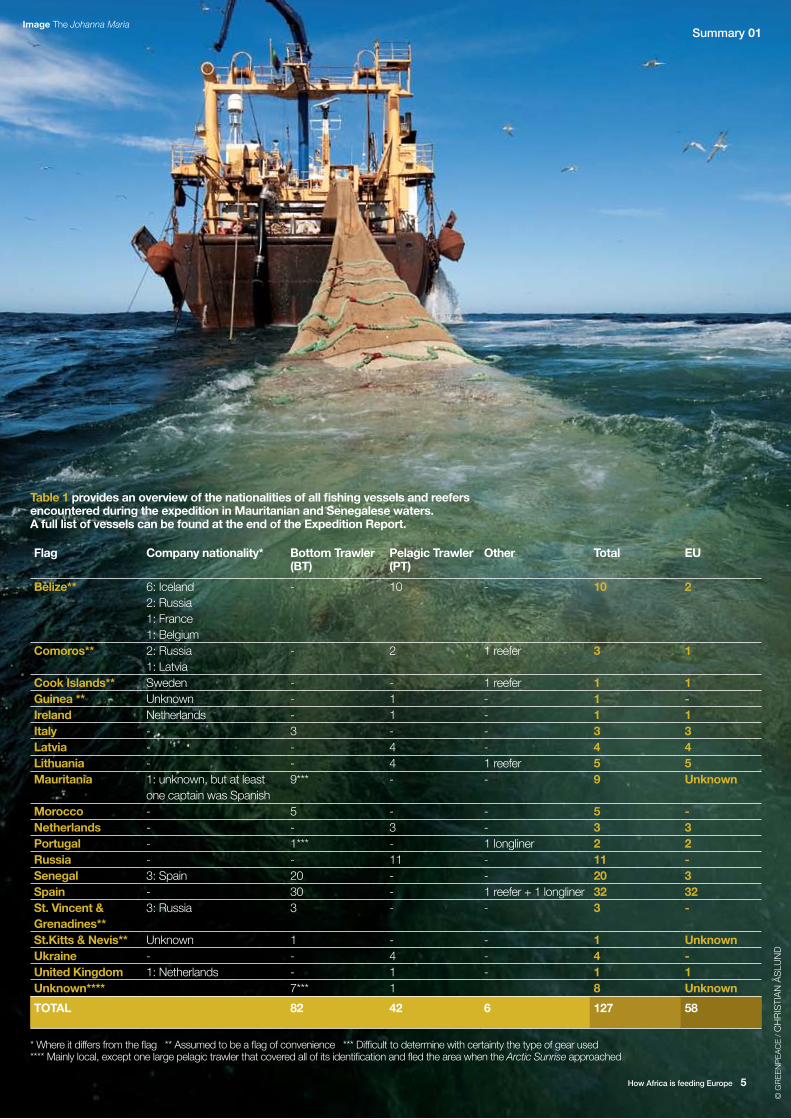
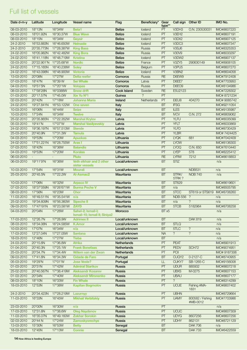
Table 1 provides an overview of the nationalities of all fishing vessels and reefers encountered during the expedition in Mauritanian and Senegalese waters. A full list of vessels can be found at the end of the Expedition Report.
Flag Company nationality* Bottom Trawler (BT)
Pelagic Trawler (PT)
Other Total EU
Belize** 6: Iceland2: Russia1: France1: Belgium
- 10 - 10 2
Comoros** 2: Russia1: Latvia
- 2 1 reefer 3 1
Cook Islands** Sweden - - 1 reefer 1 1Guinea ** Unknown - 1 - 1 -Ireland Netherlands - 1 - 1 1Italy - 3 - - 3 3Latvia - - 4 - 4 4Lithuania - - 4 1 reefer 5 5Mauritania 1: unknown, but at least
one captain was Spanish9*** - - 9 Unknown
Morocco - 5 - - 5 -Netherlands - - 3 - 3 3Portugal - 1*** - 1 longliner 2 2Russia - - 11 - 11 -Senegal 3: Spain 20 - - 20 3Spain - 30 - 1 reefer + 1 longliner 32 32St. Vincent & Grenadines**
3: Russia 3 - - 3 -
St.Kitts & Nevis** Unknown 1 - - 1 UnknownUkraine - - 4 - 4 -United Kingdom 1: Netherlands - 1 - 1 1Unknown**** 7*** 1 8 Unknown
TOTAL 82 42 6 127 58
Image The Johanna Maria
* Where it differs from the flag ** Assumed to be a flag of convenience *** Difficult to determine with certainty the type of gear used **** Mainly local, except one large pelagic trawler that covered all of its identification and fled the area when the Arctic Sunrise approached

6 How Africa is feeding EuropeHow Africa is feeding Europe6

Europe’s largest and most powerful vesselsAmong the vessels encountered were 12 of the EU’s largest and most powerful vessels. These vessels rank among the top 50 vessels in the EU, based on a tonnage of over 3,000 GT, an engine power of more than 5,000 kWh and/or length of over 100 metres. The following table provides an overview of the largest, most powerful EU vessels sighted at sea. These are all pelagic freezer trawlers.
Image Action against Trawler Willem vd Zwan. A Greenpeace
inflatable behind the trawler Willem van der Zwan: SCH302,
owned by Dutch company W van der Zwan & Zn BV, and represented by the Pelagic
Freezer-trawler Association. The vessel was built in 2000 and is sailing under a Dutch flag.
With a length of 142.3 metres, it can presumably process 300 tons per day and has a freezing
capacity of 6.000 tons.
© G
RE
EN
PE
AC
E /
CH
RIS
TIA
N Å
SLU
ND
02
Name Flag Technical specifications
Length (metres)
Gross Tonnage (GT)
Engine Power (kWh)
Willem van der Zwan NL 142.5 9,494 7,920
Afrika NL 126.22 7,005 7,210
Cornelis Vrolijk FZN NL 113.97 5,579 7,117
Johanna Maria IRL 119.65 6,534 6,600
Balandis Lithuania 117.45 5,953 5,296
Stende Latvia 104.5 4,407 5,152
Aras- I Lithuania 103.7 4,378 5,148
Marshal Krylov Latvia 103.7 4,378 5,148
Marshal Vasilevskiy Latvia 103.7 4,378 5,146
Frank Bonefaas NL 119.65 6,512 4,853
Koralas Lithuania 101.48 3,879 2,854
Tamula Latvia 101.84 3,868 2,854

01 Europe’s largest and most powerful vessels
How Africa is feeding Europe8
© G
RE
EN
PE
AC
E /
CH
RIS
TIA
N Å
SLU
ND
Image The Johanna Maria.
In the spotlight: Johanna Maria and the Pelagic Freezer-Trawler AssociationThe Johanna Maria is one the largest fishing vessels in the Dutch fleet, with a length of 119 metres and a freezing capacity of 280 tonnes a day. Although flying an Irish flag, the Johanna Maria is part of a large, globally-operating fleet of Dutch-owned pelagic freezer / factory trawlers, represented in regulatory and government forums by the Pelagic Freezer-Trawler Association (PFA). The Johanna Maria was spotted on 2 March 2010 and was one of several PFA vessels encountered during the tour. Others include the Afrika, Frank Bonefaas, Willem van der Zwan and Cornelis Vrolijk FZN.
The PFA is made up of Dutch fishing companies with subsidiary companies in Germany, France and the UK. PFA vessels primarily target small coastal fish species such as herring, blue whiting, sardines and mackerel in the Northeast Atlantic near the coast of West Africa and in the Pacific Ocean. The PFA is responsible for approximately 10% of the total EU catch3. Typically, fish is processed and frozen onboard, so ships can stay at sea for weeks and even months at a time. With the best technology onboard, these vessels can find, catch and high-grade4 their catch with extreme efficiency. In spite of their technology, the vessels also haul up high levels of bycatch, or unwanted catch. In West African fisheries bycatch of sharks, manta rays and turtles presents a major problem and has contributed to these species’ decline.5
The conflict is one between the large and the small, the haves and the have-nots. When interviewed by Greenpeace, the captain of the Johanna Maria complained about the local canoes that they claim were illegally fishing in the same region and making their work more difficult because they were difficult to spot and their boats and gear often got in the way.

How Africa is feeding Europe 9
Europe’s largest and most powerful vessels 02
Joint ventures: foreign fishing effort in disguise Of the 130 ships encountered, three were flagged to either Senegal or Mauritania but had clear links to EU operators or beneficiaries, notably Spain. These vessels likely operate under joint ventures between European fishing companies and locally-based operators. Such joint ventures, in which European fishing companies invest and collaborate with locally-based fishing companies, are encouraged by the EU’s Common Fisheries Policy, which considers them a useful way of investing into the economy of developing nations, and safeguarding the EU fishing interests in third country waters.
However, joint ventures can critically undermine fisheries management in three important ways. Firstly, operators are encouraged to move excessive fishing capacity from Europe to third countries, by shifting fishing vessels that are no longer allowed to fish in the EU to new waters, regardless of whether this contributes to overfishing. Secondly, a number of joint ventures have been criticised for not adding value - in terms of local employment, income and food security, supporting sustainable livelihoods, and even for causing a further deterioration of fish population levels and local marine ecosystems. Finally, joint ventures also present a problem in terms of determining the actual foreign fishing effort taking place in regions like West Africa. For example, since the termination of the FPA between the EU and Senegal, many vessels, notably from Spain, have simply reflagged their vessels to Senegal. This means that there is less EU oversight over what is actually being caught by EU operators, as these vessels no longer fall under the jurisdiction of the EU Common Fisheries Policy. Interviews with local businessmen in Dakar reveal that Spanish fishing effort in the area has grown since the termination of the FPA and that much of the fish caught through joint venture agreements in Senegal is destined for the EU market.
During the tour, Greenpeace identified at least three bottom trawlers that are likely to operate under joint ventures.
The Marsor Primero flies a Senegalese flag, but is owned by the Eduardo Vieira S.A. group, a Spanish company with a global reach. Spain uses massive amounts of EU and national subsidies to maintain and grow its fishing fleet. Between 2000 and 2006, Spain received almost 50% of the EU’s fisheries subsidies6. Marsor Primero is no exception and has received €1,148,287.05 of European subsidies in the past, for modernisation of the vessel and ‘joint enterprises’7. According to an interview with the captain, the vessel was catching about 400-500kg of octopus a day, also the target species for the local fishermen.
The Segundo San Rafael in Senegal is also part of the Eduardo Vieira S.A. group. Finally the Kanball III, although flying a Senegalese flag, is also owned by a large Spanish company, the group Armadora Pereira S.A, which has operations around the world.
Fisheries Partnership Agreements: who in the EU is fishing in Mauritania The EU maintains a Fisheries Partnership Agreement (FPA) with Mauritania, for which it has paid €305 million in the period 2006-2009 and has earmarked a further €64 million to the Mauritanian government for 2010, and is set to pay an equivalent amount for the next two years. In addition to these payments, which are paid by European tax-payers, EU ship owners who fish in Mauritanian waters under the agreement pay an additional, individual contribution as part of their fishing licence.
The FPA with Mauritania is the largest fisheries agreement of the EU, enabling around 130 European vessels, mostly from Spain, Italy, Portugal, France and Greece, to fish in Mauritanian waters. In principle, the agreement should only apply to fish stocks that are not already fished to their full capacity by Mauritanian fishermen, or other vessels with which Mauritania has fishing agreements. Vessels may catch certain crustaceans, cephalopods (like squid), tuna, pelagic species (like mackerel), black hake and other demersal species. However, the reality is that the EU targets stocks that are already overfished or at the limits of exploitation.
All EU-flagged vessels that Greenpeace encountered were either fishing or transiting Mauritanian waters, and were presumably registered to fish under the Mauritanian agreement. We did not have the means to verify whether they had licences to fish or not. No EU-flagged vessels were spotted in Senegalese waters (where no FPA exists).
© G
RE
EN
PE
AC
E /
CH
RIS
TIA
N Å
SLU
ND
Image European and Spanish flags on a Spanish trawler fishing for shrimp in Mauritanian waters

Image Skipjack and yellowfin tuna from the Spanish purse seiner Iribar Zulaika, waiting to be exported from Dakar.
“I used to be able to catch about 20 groupers in one day. Now, I can’t catch more than two.”Local fisherman in Soumbedioune fish market, Dakar, Senegal

The problemMany of Europe’s fishing fleets have the capacity to fish two to three times more than the sustainable level. This overcapacity has led to the current dire state of European fisheries. Rather than solve this problem, the EU has progressively been increasing their capacity in seas beyond its own to meet the growing global demand for seafood and to keep their fleets in business. Several of Europe’s largest vessels are currently operating in waters of some of the world’s poorest nations through fisheries partnership agreements or joint ventures, undermining local food security by failing to adequately consider the local communities’ need for local fish as a source of protein and income. This problem will be exacerbated particularly as climate change impacts worsen in the region.
According to views expressed by local fishermen in Senegal and Mauritania, a consequence of foreign operations in West Africa local fishing communities sees their own catch diminish and sees the destruction of local marine resources at the hands of foreign operators, while the communities themselves reap few if any of the benefits.
Image Young girl holding from a Dakar fishing community
03
© G
RE
EN
PE
AC
E /
CH
RIS
TIA
N Å
SLU
ND
© G
RE
EN
PE
AC
E /
CH
RIS
TIA
N Å
SLU
ND

How Africa is feeding Europe12
The EU and its Member States are morally responsible for supporting sustainability in less-developed countries and must prevent any conflict and/or competition with the interests, environmental integrity and food security of these countries

The way forwardInstead of transferring EU overfishing to foreign waters, Greenpeace believes that the EU should act immediately to recover its own fish stocks through the creation of marine reserves - areas of water off-limits to fishing and industrial activities - and through mandating more sustainable fishing practices.
Moreover, the EU’s external fisheries-related policies must as a minimum share the same or equivalent principles, objectives, standards and targets as its domestic policies. This is also the case for projects and investment schemes in which the EU, EU governments and EU-based companies engage. Any projects that are pursued in this manner should be conducted in the spirit of cooperation and solidarity, and should aim to meet the UN millennium goals.
With the current review of the EU’s Common Fisheries Policy underway, Greenpeace is calling for:
■ Legally-binding fishing fleet reductions and a shift in fleet structure toward environmentally-sound and socially acceptable fisheries that end overcapacity and destructive fishing practices, ensuring vessels are taken out of the water and scrapped.
■ Rules that require and support the designation and protection of marine reserves as a central part of regional fisheries management strategies.
■ Provisions to promote science-based decision-making, in particular the introduction of a legal cap on Total Allowable Catches at scientifically recommended levels.
■ Provisions that promote transparency in data-handling and decision-making, accountability in fisheries policy and management, and traceability of seafood products.
04
Image Catch from Senegalese Bottom
Trawler. Catch from the Senegalese bottom trawler Nikolaos K, fishing in Gambian
waters while pending a Senegalese license.
© G
RE
EN
PE
AC
E /
CH
RIS
TIA
N Å
SLU
ND
14 How Africa is feeding Europe
Date d-m-y Latitude Longitude Vessel name Flag Beneficiary* Gear type**
Call sign Other ID IMO No.
08-03-2010 18°13N 16°34W Beta1 Belize Iceland PT V3DH3 O.N. 230530031 IMO#860722008-03-2010 18°01.92N 16°30.37W Blue Wave Belize Iceland PT V3EH2 IMO#860719108-03-2010 18°15N 16°34W Geysir Belize Iceland PT V3DX2 IMO#890712524-2-2010 16°53.883N 16°46.650W Heinaste Belize Iceland PT V3DC3 IMO#860734724-2-2010 20°35.773N 17°28.387W King Bass Belize Russia PT V3SJ6 IMO#832535324-02-2010 16°05.982N 16°42.482W King Bora Belize Russia PT V30V9 IMO#803329724-02-2010 16°41.118N 16°48.719W Kristina Belize Iceland PT V3DW2 IMO#890713703-03-2010 20°22.901’N 17°25.68’W Nordic Belize France PT V3ZY5 290630149 IMO#890810524-02-2010 17°15.165N 16°40.238W Soley Belize Belgium PT V3PU5 IMO#860727024-02-2010 16°43.098N 16°48.900W Victoria Belize Iceland PT V3BN2 IMO#860405813-03-2010 20°08N 17°27W Delta reefer Comoros Russia RE D6EW9 IMO#791240807-03-2010 18°47N 16°39 W Sei Whale Comoros Latvia PT D6EE7 IMO#770395004-03-2010 19°51’5N 17°20’1W Volopas Comoros Russia PT D6EO9 IMO#813498608-03-2010 17°58’28N 16°0388W Snow drift Cook Island Sweden RE E5U2123 IMO#722830201-03-2010 20°17.57N 17°45.0W Xin Yu Nº1 Guinea ? PT IMO# 872123402-03-2010 20°42N 17°18W Johanna Maria Ireland Netherlands PT EIEU8 404270 IMO# 908574224-02-2010 19°27.841N 16°53.122W One seven Italy BT IFSG IMO#921105410-03-2010 16°06N 16°44W Seize Italy BT ILES IMO#913598710-03-2010 17°24N 16°34W Twelve Italy BT IVCV O.N. 272 IMO#880906225-02-2010 20°35.865N 17°22.352W Marshal Krylov Latvia PT YLFU IMO#803509905-03-2010 19°41’N 17°07’W Marshal Vasilyevskiy Latvia PT YFLT IMO#803386924-02-2010 19°36.197N 16°57.513W Stende Latvia PT YLFD IMO#873042925-03-2010 20°40.9N 17°31.3W Tamula Latvia PT YLBR IMO# 742442504-03-2010 19°53N 17°20W Apuokas Lithuania PT LYQK 681 IMO#704240924-02-2010 17°51.221N 16°28.755W Aras I Lithuania PT LYOW IMO#813630007-03-2010 18°42N 16°36W Balandis Lithuania PT LYOQ O.N. 650 IMO#761044004-03-2010 19°53N 17°20W Koralas Lithuania PT LYEP 578 IMO#822541206-03-2010 - - Pluto Lithuania RE LYRW 7212 IMO#861885306-03-2010 19°11’9’N 16°36W Veth elkhair and 2 other
sister vesselsLocal/unknown BT STIZ n/a
10-03-2010 17°54N 16°31W Mourali Local/unknown BT NDB531 n/a25-03-2010 20°45.5N 17°22.2W Al-Asmac2 Mauritania BT STRK/
5TRK ?NOB 740 n/a
10-03-2010 17°06N 16°32W Arpeco IV Mauritania BT ST629 IMO#861960107-03-2010 18°37’059N 16°26’671W Burma Peche V Mauritania BT n/a IMO#850579508-03-2010 17°56N 16°23W Chor Mauritania BT 5TCC ST619 or STS619 IMO#870626011-03-2010 16°49.511N 16°35.541W n/a Mauritania BT NDB-556 ? n/a25-02-2010 19°34.609N 16°56.360W Sipeche II Mauritania BT n/a ? n/a09-03-2010 17°47191N 16°23.581W ZAYD Mauritania BT 5TCB 5182964 IMO#870625804-03-2010 20°04N 17°26W Sahel-2; Ismail-I;
Ismail-10; Ismail II; Siniya2Morocco BT x5 n/a
17-03-2010 12°26.7N 17°26.9W Adrimex II Local/unknown BT DAK 819 n/a08-03-2010 18°34.06N 16°24.585W K.Amor Local/unknown BT STLQ n/a10-03-2010 17°07N 16°34W n/a Local/unknown BT 5TLC ? n/a17-03-2010 12°27.04N 17°27.05W Santana Local/unknown NA ? ? n/a18-03-2010 12°46N 17°27W Tieba Local/unknown BT n/a24-03-2010 20°15.6N 17°36.8W Afrika Netherlands PT PEAT IMO#890191301-04-2010 20°40.3N 17°25.1W Frank Bonefaas Netherlands PT PEDV SCH72 IMO#907495125-03-2010 20°34.7N 17°34.4W Willem van der Zwan Netherlands PT PCII IMO# 918730609-03-2010 17°41.6N 16°34.3W Cidade de Faro Portugal BT CUQY2 0-2127-C IMO#874095505-03-2010 19°29’N 17°01’W Jose Veste? Portugal LL CUKY7 SB-1265-C IMO#915600801-03-2010 20°31N 17°42W Admiral Starikov Russia PT UDUR 885932 IMO#860721825-02-2010 20°40.567N 17°38.419W Aleksandr Kosarev Russia PT UBXS M-0275 IMO#860715301-03-2010 20°34N 17°40W Aleksandr Mironenko Russia PT UBAU IMO#860717708-03-2010 18°10N 16°33W Fin Whale Russia PT ? IMO#831429918-03-2010 12°53N 17°38W Kapitan Bogmolov Russia PT UCUE Fishing #MA-
1831IMO#8607402
24-2-2010 20°34.423N 17°28.219W Lazurnyy Russia PT UBHN IMO#872966411-03-2010 16°33N 16°45W Mikhail Verbitskiy Russia PT UAMY 800582 / Fishing
#MB-0012IMO#7703986
23-03-2010 20°00N 16°30W n/a Russia PT n/a17-03-2010 12°31.6N 17°38.6W Oleg Naydenov Russia PT UCUC IMO#860730911-03-2010 16°35.07N 16°49.160W Zakhar Sorokin Russia PT UDYG 8607256 IMO#860725602-03-2010 20°44 N 17°24W Zamoskyorechye Russia PT UDHY 862131 IMO#872112913-03-2010 15°30N 16°53W Betty Senegal BT DAK 706 n/a18-03-2010 12°45N 17°13W Connie Senegal BT DAK 733 IMO#6422559
Full list of vessels
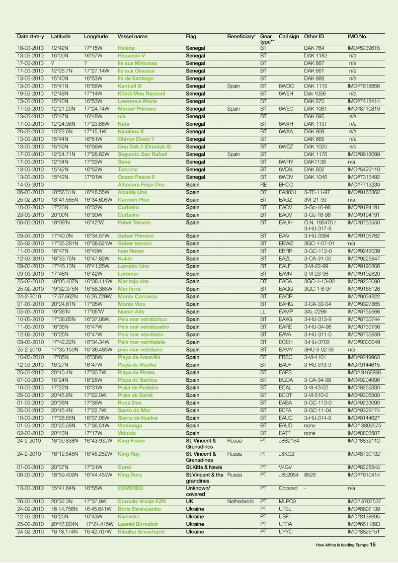
How Africa is feeding Europe 15
Date d-m-y Latitude Longitude Vessel name Flag Beneficiary* Gear type**
Call sign Other ID IMO No.
18-03-2010 12°42N 17°15W Helene Senegal BT DAK 764 IMO#523961813-03-2010 16°00N 16°57W Hispasen V Senegal BT DAK 1182 n/a17-03-2010 ? ? Ile aux Mimosas Senegal BT DAK 667 n/a17-03-2010 12°26.7N 17°27.14W Ile aux Oiseaux Senegal BT DAK 661 n/a13-03-2010 15°40N 16°53W Ile de Santiago Senegal BT DAK 668 n/a13-03-2010 15°41N 16°58W Kanball III Senegal Spain BT 6WGC DAK 1115 IMO#761885619-03-2010 12°48N 17°14W Khadi Mou Rassoul Senegal BT 6WEH Dak 1056 n/a13-03-2010 15°40N 16°53W Lawrence Morie Senegal BT DAK 670 IMO#741841417-03-2010 12°21.20N 17°24.74W Marsor Primero Senegal Spain BT 6WEC DAK 1061 IMO#871081913-03-2010 15°47N 16°48W n/a Senegal BT DAK 695 n/a17-03-2010 12°24.98N 17°23.85W Nata Senegal BT 6WXH DAK 1137 n/a20-03-2010 13°22.6N 17°15.1W Nicolaos K Senegal BT 6WAA DAK 909 n/a13-03-2010 15°44N 16°51W Ohmor Dsalo ? Senegal BT DAK 665 n/a13-03-2010 15°59N 16°56W Onu Dak 2 (Onudak II) Senegal BT 6WCZ DAK 1025 n/a17-03-2010 12°24.71N 17°28.62W Segundo San Rafael Senegal Spain BT DAK 1176 IMO#881809917-03-2010 12°34N 17°33W Sona Senegal BT 6WHY DAK1138 n/a13-03-2010 15°42N 16°52W Tadorne Senegal BT 6VQN DAK 602 IMO#542911013-03-2010 15°42N 17°01W Ocean Pesca II Senegal BT 6WDV DAK 1046 IMO#731549214-03-2010 Albacora Frigo Dos Spain RE EHQO IMO#771323006-03-2010 18°56’31N 16°48.55W Alcalde Uno Spain BT EA3031 3-TE-11-97 IMO#916336225-02-2010 18°41.565N 16°34.606W Carmen Pilar Spain BT EAGZ 3VI-21-99 n/a10-03-2010 17°23N 16°32W Curbeiro Spain BT EACV 3-Gc-16-98 IMO#919419123-03-2010 20°00N 16°30W Curbeiro Spain BT EACV 3-Gc-16-98 IMO#919419106-03-2010 19°09’N 16°42’W Febel Tercero Spain BT EAUH O.N. 195470 /
3-HU-317-9IMO#8733550
09-03-2010 17°40.0N 16°34.57W Gober Primero Spain BT EAIV 3-HU-3394 IMO#910576225-02-2010 17°35.281N 16°38.521W Gober tercero Spain BT EBWZ 3GC-1-07-01 n/a11-03-2010 16°47N 16°40W Ivan Nores Spain BT EBRR 3-GC-112-0 IMO#924203912-03-2010 16°33.75N 16°47.82W Kukin Spain BT EAZL 3-CA-31-00 IMO#922584709-03-2010 17°48.13N 16°41.25W Lameiro Uno Spain BT EALF 3-VI-22-99 IMO#919280609-03-2010 17°48N 16°42W Loremar Spain BT EAVN 3-VI-23-98 IMO#919282025-02-2010 19°05.407N 16°38.114W Mar rojo dos Spain BT EABA 3GC-1-13-00 IMO#923309025-02-2010 19°32.375N 16°58.366W Mar terra Spain BT EAQG 3GC-1-6-97 IMO#916512624-2-2010 17 57.662N 16 26.729W Monte Carrasco Spain BT EACR IMO#903482201-03-2010 20°24.61N 17°35W Monte Vios Spain BT EAHG 3-CA-33-04 IMO#932786505-03-2010 19°36’N 17°05’W Nuevo Atis Spain LL EAMP 3AL-2299 IMO#873956610-03-2010 17°38.85N 16°37.08W Peix mar veinticinco Spain BT EAXG 3-HU-313-9 IMO#873374411-03-2010 16°35N 16°47W Peix mar veinticuatro Spain BT EARE 3-HU-34-98 IMO#873375612-03-2010 16°25N 16°47W Peix mar veintiseis Spain BT EAVA 3-HU-311-0 IMO#873385909-03-2010 17°42.22N 16°34.34W Peix mar veintisiete Spain BT ECEH 3-HU-3703 IMO#930004925-2-2010 17°35.159N 16°36.486W peix mar veintiuno Spain BT EAMY 3HU-3-02-96 n/a10-03-2010 17°05N 16°38W Playa de Areavilla Spain BT EBSC 3-VI-4101 IMO#924996012-03-2010 16°27N 16°47W Playa de Huelva Spain BT EAUF 3-HU-313-9 IMO#914461525-03-2010 20°40.4N 17°30.7W Playa de Pintes Spain BT EAPS IMO# 916899607-03-2010 18°24N 16°28W Playa do Santos Spain BT EGOA 3-CA-34-98 IMO#920499610-03-2010 17°22N 16°31W Praia de Rodeira Spain BT ECAL 3-VI-43-02 IMO#926533025-03-2010 20°45.6N 17°22.0W Praia de Samil Spain BT ECDT 3-VI-510-0 IMO#930650001-03-2010 20°38N 17°36W Roca Dos Spain BT EABA 3-GC-113-0 IMO#923309025-03-2010 20°45.4N 17°22.7W Santo do Mar Spain BT ECFA 3-GC-11-04 IMO#932917410-03-2010 17°28.85N 16°37.08W Sierra de Huelva Spain BT EAUC 3-HU-314-9 IMO#914462701-03-2010 20°25.28N 17°36.51W Varalonga Spain BT EAUD none IMO# 880357502-03-2010 20°43N 17°17W Viduido Spain BT EATT none IMO#880358724-2-2010 16°09.838N 16°43.930W King Fisher St. Vincent &
GrenadinesRussia PT J8B2154 IMO#8832112
24-2-2010 16°12.545N 16°45.252W King Ray St. Vincent & Grenadines
Russia PT J8KQ2 IMO#8730132
01-03-2010 20°37N 17°31W Coral St.Kitts & Nevis PT V4GV IMO#822854306-03-2010 18°59.409N 16°44.459W King Dory St.Vincent & the
grandinesRussia PT J8b2054 8526 IMO#7610414
13-03-2010 15°41.84N 16°55W COVERED Unknown/covered
PT Covered - n/a
26-03-2010 20°32.3N 17°37.9W Cornelis Vrolijk FZN UK Netherlands PT MLPC9 IMO# 870753724-02-2010 16 14.756N 16 45.641W Boris Derevyanko Ukraine PT UTSL IMO#860713912-03-2010 16°20N 16°43W Kiyevska Ukraine PT USFI IMO#813869525-02-2010 20°47.804N 17°24.415W Leonid Borodich Ukraine PT UTRA IMO#651189324-02-2010 16 18.174N 16 42.707W Ribalka Sevastopol Ukraine PT UYYC IMO#8826151

Greenpeace is an independent global campaigning organisation that acts to change attitudes and behaviour, to protect and conserve the environment and to promote peace. Greenpeace InternationalOttho Heldringstraat 5The NetherlandsTel: +31 20 7182000Fax: +31 20 7182002
greenpeace.org
Image Seagulls pick fish from the catch of the Dutch factory trawler Afrika. The vessel is owned by the Dutch company Jaczon BV and represented by the Pelagic Freezer-trawler Association
References1 www.greenpeace.org/international/global/international/planet-2/report/2007/8/plunder2006.pdf
2 www.greenpeace.org/international/Global/international/planet-2/report/2001/10/witnessing-the-plunder-a-repo.pdf
3 De hervorming van het Europese visserijbeleid: pompen of verzuipen. Greenpeace Netherlands, November 2009 www.greenpeace.nl/raw/content/reports/de-hervorming-van-het-europese.pdf
4 ‘High-grading’ is where lower-value fish are thrown back into the ocean -often dead or dying - to make space for more valuable fish catches
5 JaapJan Zeeberg, Ad Corten, Erik de Graaf (2006), Bycatch and release of pelagic megafauna in industrial trawler fisheries off Northwest Africa in Fisheries. Research 78, 186-195
6 www.greenpeace.org/international/en/publications/reports/spain-CFP/
7 www.fishsubsidy.org
© G
RE
EN
PE
AC
E /
CH
RIS
TIA
N Å
SLU
ND