HORIZON 2020 - Lawrence, Kansas...HORIZON 2020. The Comprehensive Plan . for Lawrence and ....
51
HORIZON 2020 The Comprehensive Plan for Lawrence and Unincorporated Douglas County December 10, 2009 Amendment Plan prepared by the Lawrence/Douglas County Metropolitan Planning Office based upon recommendations from the HORIZON 2020 Steering Committee. Adopted by the Planning Commission on May 22, 1996. Adopted by the City Commission January 28, 1997. Reprint May 2004
Transcript of HORIZON 2020 - Lawrence, Kansas...HORIZON 2020. The Comprehensive Plan . for Lawrence and ....
HORIZON 2020
The Comprehensive Plan for Lawrence and
Unincorporated Douglas County
December 10, 2009 Amendment
Plan prepared by the Lawrence/Douglas County Metropolitan Planning Office based upon recommendations from the HORIZON 2020 Steering Committee. Adopted by the Planning Commission
on May 22, 1996. Adopted by the City Commission January 28, 1997.
Reprint May 2004

HORIZON 2020
The Comprehensive Plan for Lawrence and
Unincorporated Douglas County
1998 Revised Edition
HORIZON 2020 ADOPTED:
Lawrence/Douglas County Metropolitan Planning Commission May 22, 1996 Lawrence City Commission January 28, 1997 Douglas County Board of County Commissioners May 18, 1998
AMENDMENTS SINCE ADOPTION: 1.
Lawrence/Douglas County Metropolitan Planning Commission - December 17, 1997 Map 3-2-Inset, Future Land Use - City of Lawrence
Lawrence City Commission - February 17, 1998 2.
Lawrence/Douglas County Metropolitan Planning Commission - April 29, 1998
Regarding Rural Development Issues and the Urban Growth Area Boundary (including a revised format)
Douglas County Board of County Commissioners - May 18, 1998 Lawrence City Commission - June 9, 1998
3. Lawrence/Douglas County Metropolitan Planning Commission - March 15, 2000 Extend the Urban Growth Area east of Noria (E1750) Rd
Douglas County Board of County Commissioners - March 22, 2000 Lawrence City Commission - April 11, 2000
4.
Lawrence/Douglas County Metropolitan Planning Commission - February 28, 2001
Adding public health facilities text to Chapter Ten, Section Twelve concerning “Municipal Buildings and Facilities, Health Services
Douglas County Board of County Commissioners - March 28, 2001 Lawrence City Commission - March 27, 2001
5.
Lawrence/Douglas County Metropolitan Planning Commission - May 23, 2001
Updating of population projections in Chapter Two and modification of Table of Contents and Table and Figure listing
Douglas County Board of County Commissioners - August 15, 2001 Lawrence City Commission - June 12, 2001
6.
Lawrence/Douglas County Metropolitan Planning Commission – October 22, 2003 Update to Chapter Twelve – Economic Development
Douglas County Board of County Commissioners - November 19, 2003 Lawrence City Commission - November 18, 2003 Effective date - December 1, 2003
7. Adoption of Revised Major Thoroughfares MapsLawrence/Douglas County Metropolitan Planning Commission – November 19, 2003
- (Pages 8-5 and 8-6)
Douglas County Board of County Commissioners - December 15, 2003 Lawrence City Commission - December 30, 2003 Effective date - January 4, 2004
8. Expansion of the Urban Growth Area
Lawrence/Douglas County Metropolitan Planning Commission – December 17, 2003 - (Pages 3-3, 3-5, and 4-3)
Douglas County Board of County Commissioners - November 19, 2003 Lawrence City Commission - January 20, 2004 Effective date - January 31, 2004

9.
Lawrence/Douglas County Metropolitan Planning Commission – October 22, 2003 Update to Chapter Six – Commercial Land Use
Douglas County Board of County Commissioners - November 19, 2003 Lawrence City Commission - November 18, 2003 Effective date - March 16, 2004
10. Lawrence/Douglas County Metropolitan Planning Commission – March 15, 2006 Amendment to Chapter Six – Commercial Land Use
Douglas County Board of County Commissioners – September 11, 2006 Lawrence City Commission – August 8, 2006 Effective date – December 15, 2006
11. Lawrence/Douglas County Metropolitan Planning Commission – September 25, 2006 Update to Chapter Nine – Parks, Recreation and Open Space
Douglas County Board of County Commissioners – October 9, 2006 Lawrence City Commission - October 10, 2006 Effective date – January 5, 2007
12. Lawrence/Douglas County Metropolitan Planning Commission – August 21, 2006 Amendments to Chapters Four – Growth Management and Five – Residential Land Use
Douglas County Board of County Commissioners – October 18, 2006 Lawrence City Commission - December 19, 2006 Effective date – January 19, 2007
13. Lawrence/Douglas County Metropolitan Planning Commission – February 26, 2007 Amendments to Chapters Five –Residential Land Use (Figure 5-1)
Douglas County Board of County Commissioners – April 18, 2007 Lawrence City Commission – April 4, 2007 Effective date – May 4, 2007
14. Lawrence/Douglas County Metropolitan Planning Commission – June 27, 2007 Addition of Chapter Fourteen –Specific Plans
Douglas County Board of County Commissioners – August 20, 2007 Lawrence City Commission – August 14, 2007 Effective date – September 14, 2007
14.
Lawrence/Douglas County Metropolitan Planning Commission – November 28, 2007 Amendment to Chapter Fourteen –Specific Plans- Revised Southern Development Plan Reference
Douglas County Board of County Commissioners – January 7, 2008 Lawrence City Commission – December 18, 2007 Effective date – January 18, 2008
15.
Lawrence/Douglas County Metropolitan Planning Commission – November 28, 2007 Amendment to Chapter Fourteen –Specific Plans- Southeast Area Plan Reference
Douglas County Board of County Commissioners – January 28, 2008 Lawrence City Commission – January 15, 2008 Effective date – February 12, 2008
16.
Lawrence/Douglas County Metropolitan Planning Commission – November 28, 2007
Amendment to Chapter Fourteen –Specific Plans- Farmland Industries Redevelopment Plan Reference
Douglas County Board of County Commissioners – March 31, 2008 Lawrence City Commission – March 11, 2008 Effective date – April 5, 2008

17. Lawrence/Douglas County Metropolitan Planning Commission – February 27, 2008 Amendments to Chapter Six – Commercial Land Use
Douglas County Board of County Commissioners – April 28, 2008 Lawrence City Commission – April 1, 2008 Effective date – May 21, 2008
18. Lawrence/Douglas County Metropolitan Planning Commission – April 23, 2008 Amendments to Chapter Six – Commercial Land Use-Mixed Use District
Douglas County Board of County Commissioners – June 16, 2008 Lawrence City Commission – May 13, 2008 Effective date – July 9, 2008
19.
Lawrence/Douglas County Metropolitan Planning Commission – May 21, 2008 Amendment to the Southeast Area Plan
Douglas County Board of County Commissioners – July 14, 2008 Lawrence City Commission – June 24, 2008 Effective date – July 21, 2008
20. Lawrence/Douglas County Metropolitan Planning Commission – September 22, 2008 Amendment to the Southeast Area Plan
Douglas County Board of County Commissioners – November 10, 2008 Lawrence City Commission – October 7, 2008
Effective date – December 1, 2008 21.
Lawrence/Douglas County Metropolitan Planning Commission – October 20, 2008 Amendment to Chapter Six – Commercial Land Use – Neighborhood Commercial Centers
Douglas County Board of County Commissioners – December 8, 2008 Lawrence City Commission – November 11, 2008
Effective date – December 18, 2008 22.
Lawrence/Douglas County Metropolitan Planning Commission – October 20, 2008 Amendment to Chapter Six – Commercial Land Use – Renumber Goal 3
Douglas County Board of County Commissioners – December 8, 2008 Lawrence City Commission – November 11, 2008
Effective date – December 18, 2008 23.
Lawrence/Douglas County Metropolitan Planning Commission – November 17, 2008 Amendment to Chapter Fourteen – Specific Plan – K-10 & Farmer’s Turnpike Plan
Douglas County Board of County Commissioners – January 7, 2009 Lawrence City Commission – December 9, 2008
Effective date – January 11, 2009 24.
Lawrence/Douglas County Metropolitan Planning Commission – November 17, 2008 Amendment to Chapter Six – Commercial Land Use- Inner-Neighborhood Commercial Centers
Douglas County Board of County Commissioners – February 9, 2009 Lawrence City Commission – December 2, 2008
Effective date – March 1, 2009 25.
Lawrence/Douglas County Metropolitan Planning Commission – May 21, 2008 Addition of Chapter Fifteen – Place Making Elements
Douglas County Board of County Commissioners – February 23, 2009 Lawrence City Commission – January 27, 2009

Effective date – March 17, 2009
26. Lawrence/Douglas County Metropolitan Planning Commission – May 21, 2008 Amendment to Chapter Fourteen – Specific Plan – Lawrence SmartCode Infill Plan
Douglas County Board of County Commissioners – February 23, 2009 Lawrence City Commission – January 27, 2009
Effective date – March 17, 2009 27.
Lawrence/Douglas County Metropolitan Planning Commission – March 25, 2009 Amendment to Chapter Fourteen – Specific Plan – West of K-10 Plan
Douglas County Board of County Commissioners – May 6, 2009 Lawrence City Commission – June 9, 2009
Effective date – June 21, 2009 26.
Lawrence/Douglas County Metropolitan Planning Commission – April 22, 2009 Update to Chapter Seven – Industrial and Employment-Related Land Use
Douglas County Board of County Commissioners – August 5, 2009 Lawrence City Commission – June 9, 2009
Effective date – August 15, 2009 27.
Lawrence/Douglas County Metropolitan Planning Commission – May 18, 2009
Amendment to Chapter Four- Growth Management & Chapter Six –Commercial Land Use-Rural Tourism Facilities
Douglas County Board of County Commissioners – June 24, 2009 Lawrence City Commission – August 18, 2009
Effective date – August 29, 2009 28.
Lawrence/Douglas County Metropolitan Planning Commission – September 21, 2009 Amendment to Chapter Three – General Plan Overview-Remove Land Use Categories Table
Douglas County Board of County Commissioners – November 18, 2009 Lawrence City Commission – October 27, 2009
Effective date – November 25, 2009 29.
Lawrence/Douglas County Metropolitan Planning Commission – September 21, 2009 Renumber the Implementation Chapter to Chapter Seventeen
Douglas County Board of County Commissioners – November 18, 2009 Lawrence City Commission – October 27, 2009
Effective date – November 25, 2009
Commercial Land Use

HORIZON 2020 6-1 COMMERCIAL
CHAPTER SIX - COMMERCIAL LAND USE The Plan’s goal is to strengthen and reinforce the role and function of existing commercial areas within Lawrence and Douglas County and promote economically sound and architecturally attractive new commercial development and redevelopment in selected locations. STRATEGIES: COMMERCIAL DEVELOPMENT The principal strategies for the development and maintenance of commercial land use areas are:
• Support downtown Lawrence as the Regional Retail/Commercial/Office/Cultural Center with associated residential uses through the careful analysis of the number, scale, and location of other mixed-use commercial/retail developments in the community. Downtown Lawrence is the cultural and historical center for the community and shall be actively maintained through implementation of the adopted design guidelines that regulate the architectural and urban design character of this regional center.
• Establish and maintain a system of commercial development nodes at selected
intersections which provide for the anticipated neighborhood, community and regional commercial development needs of the community throughout the planning period.
• Require commercial development to occur in "nodes", by avoiding continuous lineal
and shallow lot depth commercial development along the city's street corridors and Douglas County roads.
• Encourage infill development and/or redevelopment of existing commercial areas
with an emphasis on Downtown Lawrence and existing commercial gateways. Sensitivity in the form of site layout and design considerations shall be given to important architectural or historical elements in the review of development proposals.
• Improve the overall community image through development of site layout and
accessibility plans that are compatible with the community's commercial and retail areas.
• Require new Commercial Centers in the unincorporated portion of Douglas County to
be located at the intersection of two hard surfaced County Routes or the intersection of a hard surfaced county route and a state or federally designated highway and no closer than four miles to another Commercial Center in the unincorporated portion of Douglas County.

HORIZON 2020 6-2 COMMERCIAL
NODAL DEVELOPMENT The Goals and Strategies in this chapter center on the Nodal Development Concept for new commercial development and the definitions of the four different categories of commercial nodes: Neighborhood, CC200, CC400, and Regional Commercial. The Nodal Development Concept encompasses all four corners of an intersection, although all four corners do not need to be commercially developed. The concept of nodal development shall also be applied to the redevelopment of existing commercial areas when the redevelopment proposal enlarges the existing commercial area. The following text provides a detailed description of the appropriate uses and development patterns for each respective category of commercial development. Nodal Development is the antithesis of “Strip Development”. “Strip Development” is characterized by high-intensity, auto-oriented uses, shallow in depth and extending linearly along a street corridor, with little consideration given to access management and site aesthetics. The Nodal Development concept requires the clear termination of commercial development within near proximity of an intersection. Commercial development that does not occur directly at the corner of an intersection must be integrated, through development plan design and platting with the property that is directly at the intersection’s corner. Termination of commercial development can be accomplished through a number of methods, including: 1) Placement of transitional uses, such as office and multi-family to buffer the adjoining neighborhood from the commercial area; 2) restricting the extension of new commercial uses past established commercial areas; and 3) defining the boundaries of the development through the use of “reverse frontage” roads to contain the commercial uses.
DESIGN STANDARDS The city shall strive to improve the design of shopping areas. The objective will be to work with commercial developers to achieve compact, pedestrian-oriented centers versus conventional strip malls. The overall goal of these standards is to improve community aesthetics, encourage more shopping per trip, facilitate neighborhood identification and support, and make shopping an enjoyable event. New design standards shall be developed and adopted which better integrate the centers into the surrounding neighborhoods and create a focal point for those that live nearby. They should include elements that reflect appropriate and compatible site design patterns and architectural features of neighboring areas. Site design and building features shall be reflective of the quality and character of the overall community and incorporate elements familiar to the local landscape. Using a variety of building incentives to encourage mixed use development will bring consumers closer to the businesses Design elements of particular interest that will receive close scrutiny include:
1. Site design features, such as building placement, open space and public areas, outdoor lighting, landscaping, pedestrian and bicycle amenities, interfacings with adjacent properties, site grading and stormwater management, parking areas and vehicular circulation (including access management).
2 Building design features, such as architectural compatibility, massing, rooflines,
detailing, materials, colors, entryways, window and door treatments, backsides of

HORIZON 2020 6-3 COMMERCIAL
buildings, service/mechanical/utility features and human-scale relationships. COMMERCIAL CENTER CATEGORIES The Comprehensive Plan includes recommendations for the improvement of existing commercial areas and the development of compatible new commercial areas. It establishes a system of commercial and retail development that applies to both existing and new development locations. This system involves the designation of different types of commercial areas to distinguish between the basic role and types of land uses and the scale of development. These include the neighborhood, community and regional commercial classifications. The following descriptions are based upon recognized standards formulated by the Urban Land Institute (ULI) and knowledge gathered by the community through past experiences. An integral component in the description of each commercial center category is the designation of an amount of commercial gross square footage deemed appropriate for each center classification. However, this plan recognizes that there will be instances in which a rezoning request for a commercial district will not be accompanied by a development plan showing the total amount of gross square footage associated with the rezoning request. In such circumstances, part of the commercial rezoning request shall include a statement regarding the maximum amount of commercial square footage that will be permitted with each particular commercial rezoning request.
■ Commercial Uses For the purposes of this section of the Plan, the term “commercial” means retail businesses that sell goods and services on-site for which sales tax is collected. This definition does not include offices or similar uses. ■ Downtown Commercial Center The Downtown Commercial Center is the historic core of governmental, commercial, institutional, social and cultural activity. Transitions to adjacent neighborhoods are traditionally provided through alleyways or landscaping improvements rather than a change in use or density. The Downtown Commercial Center is restricted to the historic commercial core of Lawrence. The boundaries of Downtown Lawrence correspond with the boundaries outlined in the “Comprehensive Downtown Plan”, and are described as: starting at the Kansas River, south along Kentucky Street to just south of Vermont Towers, then east to Vermont Street, south along Vermont Street to North Park Street, east along North Park Street to Rhode Island Street, north along Rhode Island Street to 11th Street, west along 11th Street to the alley east of New Hampshire Street, north along the New Hampshire Street alley to 9th Street, east on 9th
Street to Rhode Island Street, then north on Rhode Island Street to the Kansas River.
The Downtown Commercial Center is the Regional Retail/Commercial/Office/Cultural Center for the community and is considered a destination driver that attracts and serves the area beyond that of the local community. The Downtown Commercial Center has an established development and architectural/urban design pattern. Unique among commercial centers in Lawrence, the Downtown Commercial Center combines a variety of land uses, including governmental, retail, office, public facilities, institutions, churches, and residential. Linear in design, the Downtown Commercial Center is focused along Massachusetts Street with New Hampshire and Vermont Streets serving as

HORIZON 2020 6-4 COMMERCIAL
secondary activity areas. General building patterns are urban. Mixed-use, multi-story buildings are the most common building form and parking is provided on-street and through community parking lots and parking structures. Building designs and public improvements are focused on providing a pedestrian-oriented commercial experience. Massachusetts Street has a distinct streetscape with sawtooth parking and a focus on first floor (pedestrian oriented) retail use. Vermont and New Hampshire Streets provide the major vehicular movement patterns and provide access to the majority of the community parking areas. Alleyways, which provide service access, are one of the main character-defining elements that distinguish the Downtown Commercial Center from other commercial centers. To ensure there are a variety of commercial uses, the maximum footprint for an individual store is limited to approximately 25,000 gross square feet. One of the keys to the success of the Downtown Commercial Center is the ability to provide a wide range of leasable square footage that is both flexible and capable of being tailored to a specific use. Construction within the Downtown Commercial Center is regulated by a set of design guidelines administered through an Urban Conservation Overlay Zoning District. An important ingredient to ensuring the continued viability of Downtown is keeping it the center of the city’s social and institutional activities. To maintain downtown as the city and County’s hub of governmental functions; uses and buildings such as City Hall, the County Courthouse, Municipal Library, Douglas County Senior Center, Fire/Medical Department’s Main Office, Police and Sheriff Offices, the Municipal Pool and the Municipal and District Courts shall remain located in Downtown. ■ Neighborhood Commercial Centers The typical nodal development concept for Neighborhood Commercial Centers includes commercial on only one corner of an arterial/collector street intersection or arterial/arterial street intersection. The remaining corners are appropriate for a variety of other land uses, including office, public facilities and high density residential. Commercial development shall not be the dominant land use at the intersection or extend into the surrounding lower-density residential portions of the neighborhood. The surrounding residential area shall be provided adequate buffering from the commercial uses through transitional zoning or lower-intensity developments. Transitions shall be accomplished by using a number of methods, such as intensive landscaping and berming, grouping of lower-intensity developments, incorporation of existing natural land features into site layout and design (ex. open space along a creek), or a combination of these methods. Neighborhood Commercial Centers may contain a variety of commercial uses, including a grocery store, convenience store, and other smaller retail shops and services such as a barbershop or beauty salon. To insure there are a variety of commercial uses and that no one use dominates a Neighborhood Commercial Center, no one store shall occupy an area larger than 40,000 gross square feet. The only exception is a grocery store, which may occupy an area up to 80,000 gross square feet. A Neighborhood Commercial Center provides for the sale of goods and services at the neighborhood level. Neighborhood Commercial Centers shall contain no more than a total of 100,000 gross square feet of commercial space with the exception of Neighborhood Commercial Centers that include a grocery store. Neighborhood Commercial Centers that have a grocery store larger than 60,001 gross square feet may have up to a total of 125,000 gross square feet of commercial space. To ensure that the commercial area in a new Neighborhood Commercial Center has adequate lot
HORIZON 2020 6-5 COMMERCIAL
size and depth, any proposal for a commercial development shall have a length-to-depth ratio between 1:1 and 3:2. In order to facilitate the orderly development of future commercial nodes, Lawrence shall attempt to complete “nodal plans” for each future commercial center in advance of development proposals. If a nodal plan had not been created by the city, the need to create a nodal plan for a specific intersection shall be “triggered” by the first development request (rezoning, plat, preliminary development plan, etc.) submitted to the Planning Department for any portion of the node. The creation of the nodal plan may involve input from landowners within the nodal area, adjoining neighborhoods and property owners, and appropriate local and state entities. The appropriate governing body (City or County Commission) shall approve the nodal plan before development approval within the nodal area can move forward. M ixed-Use Redevelopment Center
The City of Lawrence includes areas where existing structures that have not been utilized for their original purposes for an extended period of time, have experienced a high turnover rate, or have remained vacant for an extended period of time and, therefore, are suitable for redevelopment. Such areas present potential opportunities for redevelopment into mixed-use centers, offering a mix of residential, civic, office, small-scale commercial, and open space uses. This mixed use is encouraged in individual structures as well as throughout the area. Mixed-use redevelopment centers shall include a mix of uses designed to maintain the character of the surrounding neighborhood, achieve integration with adjacent land uses, and be no larger than six acres in size. As such, retail uses within mixed-use redevelopment centers shall not exceed 25% of the net floor area within the subject area, and a single retail shop or tenant shall not occupy more than 16,000 square feet of a ground-floor level, net floor area. Neighborhood integration shall also be accomplished by providing transitions through alleyways and use and landscaping buffers, and by ensuring existing structures are incorporated into the new center where possible. New development shall respect the general spacing, mass, scale, and street frontage relationships of existing structures and surrounding neighborhoods. The City’s Historic Resources Administrator shall be contacted if it is likely that historic structures exist within or near the project area. Centers shall provide multi-modal services, allowing bicycle, pedestrian, vehicular, and, if available, transit options. Pedestrians should be able to navigate the site safely and efficiently, and travel to and from the site with ease. Pedestrian-scaled street furnishings, plantings, and gathering places shall be utilized to allow for social activity in public places. Bicycle parking shall be provided when required by the Zoning Regulations, and transit services shall be incorporated into the design where necessary. ■ Mixed-Use Districts The City of Lawrence includes areas where infill and new development opportunities exist that would appropriately be developed or redeveloped as a mixed-use district. Such areas present potential opportunities for development and redevelopment as mixed-use districts, offering a mix of residential and non-residential uses. This mixed use is encouraged in individual structures as well as throughout the area. There are also areas that are currently mixed use in nature that should be preserved.

HORIZON 2020 6-6 COMMERCIAL
Mixed-use districts shall include a mix of uses designed to maintain the character of the surrounding neighborhood, achieve integration with adjacent land uses, and be no larger than 20 acres in size. Neighborhood integration may also be accomplished by providing transitions through alleyways, variation among development intensity, implementation of landscaping buffers, or by ensuring existing structures are incorporated into the development where possible. New development shall respect the general spacing, mass, scale, and street frontage relationships of existing structures and surrounding neighborhoods. The City’s Historic Resources Administrator shall be included in the review process if it is likely that historic structures exist within or near the project area. Mixed use districts shall provide multi-modal services, allowing bicycle, pedestrian, vehicular, and transit options. Pedestrians should be able to navigate the site safely and efficiently, and travel to and from the site with ease. Pedestrian-scaled street furnishings, plantings, and public spaces shall be planned to be utilized to allow for social activity. Bicycle parking shall be provided when required by the Zoning Regulations, and transit services shall be incorporated into the design where necessary. ■ Inner-Neighborhood Commercial Centers A subcategory of this section is Inner-Neighborhood Commercial Centers. Typically, this is an existing commercial area within an established neighborhood. Existing Inner-Neighborhood Commercial Centers are located at:
• Southeast corner of 12th
• West side of the intersection of 14 Street and Connecticut Street
th
• Intersection of N. 7 Street and Massachusetts Street
th
• 6 Street and Locust Street
th
• E. 9 Street between Indiana Street and Mississippi Street
th
• Northeast corner of Barker Street and 23 Street corridor starting at Rhode Island and going east
rd
• 7 Street
th
• Northeast corner of 13 Street and Michigan Street.
th
and Haskell
Redevelopment of these existing Inner-Neighborhood Commercial Centers should be facilitated through the use of alternative development standards that allow for reductions in required parking, open space, setbacks, lot dimensions and other requirements that make it difficult to redevelop existing commercial areas ■ Community Commercial Center A Community Commercial Center provides goods and services to several different neighborhood areas. It requires a site of sufficient size to accommodate buildings, parking, stormwater detention and open space areas. Although it may include a food or drug store, it is likely to provide a broad range of retail uses and services that typically generate more traffic and require larger lot sizes then found in a Neighborhood Commercial Center. Community Commercial Center uses may include hardware stores, video outlets, clothing stores, furniture stores, grocery store, movie theaters, home improvement stores, auto supply and services, athletic and fitness centers, indoor entertainment centers, etc. Community Commercial Center (under 200,000 square feet): CC200

HORIZON 2020 6-7 COMMERCIAL
The primary purpose of the CC200 category is to provide for the expansion and redevelopment of existing Community Commercial Centers. However, a new CC200 Center can be designated. Expansion of an existing CC200 Center shall not intrude into surrounding residential areas or lower-intensity land uses. Any proposal for commercial expansion or redevelopment occurring in an area designated as a CC200 Center shall include a plan for reducing curb cuts, improving pedestrian connections, providing cross access easements to adjacent properties, and creating and/or maintaining buffering for any adjacent non-commercial uses. All corners of CC200 Center intersections should not be devoted to commercial uses. CC200 Centers should have a variety of uses such as office, employment-related uses, public and semi-public uses, parks and recreation, multi-family residential, etc. To insure that there are a variety of commercial uses and that no single store front dominates the CC200 Center, no individual or single store shall occupy more than 100,000 gross square feet. A general merchandise store (including discount and apparel stores) that does not exceed 65,000 gross square feet in size may be located in a CC200 Center. The sum of the gross square footage for all stores that occupy space between 40,000 and 100,000 cannot exceed 50 percent of the gross commercial square footage for the corner of the intersection where it is located. To provide adequate access and adequate circulation, CC200 Centers shall be located at an arterial/collector street intersection or arterial/arterial street intersection. CC200 Centers shall be located with primary access designed to occur from arterial or collector streets, with secondary access occurring from neighborhood feeder streets or reverse frontage roads. The purpose of the secondary access is to collect internal neighborhood traffic so that accessibility from the adjoining neighborhoods does not require exiting the neighborhood to access community shopping. These secondary access points are intended only for neighborhood traffic. The surrounding street design shall be done in a manner to discourage access to the Commercial Center by non-neighborhood traffic. Pedestrian and bike connection to the neighborhood shall be emphasized along the secondary routes. In order to facilitate the orderly development of future commercial nodes, Lawrence shall attempt to complete “nodal plans” for each future commercial center in advance of development proposals. In the absence of a city created nodal plan, the need to create a nodal plan for a specific intersection will be “triggered” by the first development request (rezoning, plat, preliminary development plan, etc.) submitted to the Planning Department for any portion of the node. The creation of the nodal plan may involve input from landowners within the nodal area, adjoining neighborhoods and property owners, and appropriate local and state entities. The appropriate governing body (City or County Commission) shall approve the nodal plan before approval of the development within the nodal area can move forward. Community Commercial Center (under 400,000 square feet): CC400 The second category of Community Commercial Centers is the CC400 Center. Although these centers usually average 150,000 gross square feet, they may be as large as 400,000 gross square feet of retail commercial space if justified by an independent market study. CC400 Centers shall be located at the intersection of two arterial streets that have at least a four-lane cross-section or the intersection of a four-lane arterial with a state or federally designated highway.

HORIZON 2020 6-8 COMMERCIAL
CC400 Centers shall be located with primary access designed to occur from arterial or collector streets, with secondary access occurring from neighborhood feeder streets or reverse frontage roads. The purpose of the secondary access is to collect internal neighborhood traffic so that accessibility from the adjoining neighborhoods does not require exiting the neighborhood to access community shopping. These secondary access points are intended only for neighborhood traffic. The surround street design shall be done in a manner to discourage access to the Commercial Center by non-neighborhood traffic. Pedestrian and bike connection to the neighborhood shall be emphasized along the secondary routes. The nodal development concept for CC400 Centers includes the possibility of commercial development on more than one corner of an intersection. The non-commercial corners of a community commercial node are appropriate for a variety of non-commercial retail uses including office, public or religious facilities, health care, and medium- to high-density residential development. Community Commercial development shall not extend into the surrounding lower-density residential portions of neighborhoods. The adjoining residential area shall be provided adequate buffering from the commercial uses through transitional zoning or development. Transitions may be accomplished by using a number of methods, including extensive landscaping and berming, grouping of lower-intensity uses, incorporation of existing natural land features into site layout and design (ex. open space along a creek), or a combination of these methods. To insure that a specific intersection complies with the CC400 Center nodal standards, a nodal plan for each new CC400 Center must be created. The nodal plan will define the area of the node and provide details including: 1) existing natural features; 2) appropriate transitional uses; 3) appropriate uses for each specific corner of the intersection; 4) access points for each corner; 5) necessary infrastructure improvements; 6) overall flow of traffic in and around the node and the surrounding area; and 7) any other necessary information.
A key element to a nodal plan is the designation of the appropriate uses for each corner of the node, which shall be governed by the above-listed details. Those details will be used to analyze a potential node. The analysis of the node may readily reveal the appropriate use for each specific corner. However, the analysis may reveal that no one use is appropriate for each specific corner, but instead a variety of uses may be considered appropriate for a specific corner. In a situation where all the corners maybe considered appropriate for commercial uses, the location of the commercial space will be dictated by the timing of the development application and the development standards located in this chapter.
In order to facilitate the orderly development of future commercial nodes; Lawrence shall attempt to complete “nodal plans” for each future commercial center in advance of development proposals.
If the city has not created a nodal plan, the need to create a nodal plan for a specific intersection will be “triggered” by the first development request (rezoning, plat, preliminary development plan, etc.) submitted to the Planning Department for any portion of the node. The creation of the nodal plan may involve input from landowners within the nodal area, adjoining neighborhoods and property owners, and appropriate local and state entities. The appropriate governing body (City or County Commission) shall approve the nodal plan before approval of the development within the nodal area can move forward.
At least 95 percent of the commercial gross square footage in a new CC400 Center shall be located on two corners of the intersection. The remaining five percent shall be located on one of the remaining two corners. To comply with the square footage maximum for a CC400 Center and to ensure that the commercial area has adequate lot size and depth, any commercial development

HORIZON 2020 6-9 COMMERCIAL
proposal for a single corner shall have a length-to- depth ratio between 1:1 and 3:2 and be a minimum of 20 acres in size. Proposals in which the commercial gross square footage is less than ten percent of the total square footage of the proposal do not have to meet the minimum acreage and lot length-to-depth ratio requirements. No one store in a CC400 Center shall occupy more than 175,000 gross square feet. The sum of the gross square footage for all stores that occupy space between 100,000 gross square feet and 175,000 gross square feet shall not exceed 70 percent of the gross commercial square footage for the corner of the intersection. If a proposal for a corner of the intersection includes more than 100,000 gross square feet of commercial space, the proposal shall include a single store building that has at least 40,000 gross square feet of commercial space. ■ Regional Commercial Centers A Regional Commercial Center may provide the same services as a Community Commercial Center but should provide a greater variety and number of general merchandise, apparel and furniture stores, among other tenants. Because of the overall scale and mix of uses, a regional retail commercial center attracts and serves a population greater than and beyond that of the community. The minimum area for a commercial development plan on any corner is 40 acres and the minimum street frontage is 1,400 linear feet. This will ensure a new Regional Commercial Center is capable of development with the critical mass mixture, including sites for multiple big box buildings, required parking, stormwater detention, and open space areas. A Regional Commercial Center node shall not contain more than 1.5 million gross square feet of retail commercial space. The only location for the next Regional Commercial Center is at the intersection of either two state or federal highways, or the intersection of a street identified on the Major Thoroughfares Map as an arterial street and a state or federal highway. Development of another Regional Commercial Center will have significant impacts on the Lawrence/Douglas County community and its existing retail centers, and will place increased service demands on the community’s infrastructure system. Due to these impacts, consideration of a Regional Commercial Center by the Planning and City Commissions shall utilize the best available information in the analysis, public hearing and decision making process. Therefore, when the next Regional Commercial Center is proposed, an independent market analysis shall be required at the review and analysis stage and prior to public hearing. The entity proposing the Regional Commercial Center shall provide the funds necessary for the city to hire an independent consultant, selected by the applicant from a list of approved consultants established by the city, to perform the market analysis study. The market analysis study shall be required, at a minimum, to analyze the proposed Regional Commercial Center based on the following criteria: 1) the overall viability of the commercial proposal and the impact of the proposal on the economic vitality and health of the community in the form of impacts on existing commercial centers; 2) the appropriate phasing or timing of development of the ultimate center size based on the community’s ability to absorb additional commercial square footage over a three year period; 3) a comparison of the private costs versus public infrastructure and services costs to develop the commercial center proposed; and 4) other factors identified as relevant impacts on the market by either the developer or the city. The three year time period is a typical cycle for a commercial development to go from a concept to the opening of a store.
HORIZON 2020 6-10 COMMERCIAL
As with the Community Commercial Center, in order to insure that a specific intersection complies with the Regional Commercial Center nodal standards, a nodal plan for a new Regional Commercial Center shall be created. The nodal plan shall define the area of the node and provide details, including: 1) existing natural features; 2) appropriate transitional uses; 3) appropriate uses for each specific corner of the intersection; 4) access points for each corner; 5) necessary infrastructure improvements; 6) overall flow of traffic in and around the node and the surrounding area; and 7) any other necessary information.
A key element to a nodal plan is the designation of the appropriate uses for each corner of the node, which shall be greatly governed by the above-listed details. Those details will be used to analyze a potential node. The analysis of the node may readily reveal the appropriate use for each specific corner. However, the analysis may reveal that no one use is appropriate for each specific corner, but instead a variety of uses may be considered appropriate for a specific corner. In a situation where all the corners may be considered appropriate for commercial uses, the location of the commercial space will be dictated by the timing of the development application and the development standards located in this chapter.
If the city has not created a nodal plan, the need to create a nodal plan for a specific intersection shall be “triggered” by the first development request (rezoning, plat, preliminary development plan, etc.) submitted to the Planning Department for any portion of the node. The creation of the nodal plan may involve input from landowners within the nodal area, adjoining neighborhoods and property owners, and appropriate local and state entities. The appropriate governing body (City or County Commission) shall approve the nodal plan before development approval within the nodal area can move forward. ■ Ex isting Strip Commercial Developments Existing strip commercial development areas are characterized by developments that do not meet current standards for lot dimensions and area, lot frontage, curb cut location(s), or the presence of internal frontage roads for cross access. These areas developed at a time when development standards permitted smaller lots, shallower lot depth, minimum spacing between curb cuts and multiple access points from a site to an arterial street; traffic studies were also not required prior to development at that time. These strip commercial development areas have become obsolete as a result of their inability to adjust to increased traffic volumes and congestion, current needs for site area and depth for redevelopment, and the changing patterns of shopping of the motoring public. As these strip areas become less desirable locations, the ability to redevelop individual lots becomes a matter of both property owner and community concern. The community concern is primarily with the creation of vacant, undeveloped or underdeveloped commercial areas that have the potential to blight the city’s gateways. A combination of innovative tools should be developed to assist owners of lots within the existing strip development areas to redevelop. These tools need to include regulations that provide accommodations for shallow lot depth, the combination of lots and access points, and the creation of cross access between lots to minimize the need for individual lot access to arterial streets. In addition, other tools of a policy nature which would be helpful to redevelopment need to be considered and, where appropriate, adopted by the appropriate governing bodies. These tools may include the ability for establishment of public/private partnerships, special overlay districts, modified development standards for redevelopment based on an adopted redevelopment plan, tools to assist in lot consolidation and purchase, adopted access management plans and access point relocations, special benefit districts for sidewalks and public transportation stops, assistance in acquiring cross

HORIZON 2020 6-11 COMMERCIAL
access easements, and similar tools providing community benefit. Existing Strip Commercial Development areas shall not be permitted to expand or redevelop into the surrounding lower-intensity areas. Redevelopment within Strip Commercial Development areas shall be approved only when the redevelopment complies with any adopted redevelopment plan or access management plan for the area. Cross access easements and curb cut consolidation should be considered a standard element of any redevelopment plan, as shall a solid screen or buffer along all property lines that adjoin residentially zoned or developed areas. ■ Auto-Related Commercial Centers A unique type of commercial development is an Auto-Related Commercial Center. These centers include a wide variety of uses such as auto sales and repair, truck stops, restaurants, hotels, and other similar uses. However, these uses are not limited to Auto-Related Commercial Centers. A common feature of all these uses is that they typically have a small amount of commercial square footage under roof, but require a large amount of acreage. Because these centers have a limited variety of uses and a relatively small amount of commercial square footage, Auto-Related Commercial Centers do not fit within the definition of a Community or Regional Commercial Center. These types of centers are very intensive and therefore need to be directed to areas that have an ability to handle the intensive nature of an Auto-Related Commercial Center. Auto-Related Commercial Centers shall be located at the intersection of two state or federally designated highways. To ensure that the Auto-Related Commercial Centers develop in a planned manner that provides a positive benefit to the community, Auto-Related Commercial Centers shall have a lot length-to-depth ratio of 3:2 and must be a minimum of 20 acres in size. All the potential locations of an Auto-Related Commercial Center are in areas that serve as “gateways” into the city. Since they are in “gateway” areas, any proposal for an Auto-Related Commercial Center shall be closely scrutinized for architectural appearance, landscaping, signage, etc. ■ Recreational Uses Commercial uses that are primarily physical recreation in nature (uses such as go-karts, skating rinks, bowling alleys, basketball arenas, soccer arenas, miniature golf, pitch and putt golf, etc.) may be located in the appropriate Commercial Center classification. High levels of noise and light can be generated by Recreational Uses. Because of this high level of noise and light, Recreational Uses shall be compatible with the surrounding existing or planned uses. Proposals for such uses do not need to meet the size or ratio requirements stated in the respective Commercial Center definitions. Proposals for Recreational Uses shall provide adequate buffering for adjacent non-commercial uses, shall use a minimal number of curb cuts, and provide cross access easements to adjoining properties. If a Recreational Use is proposed in a Neighborhood or CC200 Center, the amount of commercial gross square footage occupied by the Recreational Use shall be counted toward the maximum amount of commercial gross square footage allowed. A Recreational Use located in a CC200 can occupy up to 50,000 gross square feet. The purpose of regulating the size of Recreational Uses in

HORIZON 2020 6-12 COMMERCIAL
Neighborhood and CC200 Centers is to preserve and protect the smaller, neighborhood scale associated with these types of Centers. The amount of commercial gross square footage occupied by Recreational Uses located in a CC400 or a Regional Commercial Center shall not be counted toward the maximum amount of gross commercial square footage allowed in the respective Commercial Center. The square footage of a Recreational Use is not included in the total commercial square footage because CC400 and Regional Commercial Centers are typically larger-scale commercial developments. This reduces the impact of the Recreational Use on the scale and massing of the CC400 or Regional Center. The acreage used to accommodate a Recreational Use may be used to meet the minimum acreage requirements for a respective Commercial Center, if the Recreational Use and additional commercial uses at the corner of the node are integrated together. Community facility-type recreational facilities can be located in non-commercial areas if given the extra scrutiny that is associated with the issuance of a special permit such as a Use Permitted upon Review. LAWRENCE - EXISTING COMMERCIAL AREAS Lawrence currently has a number of commercial and retail development areas:
• Downtown Lawrence • N. 2nd Street and N. 3rd
• Iowa Street (Harvard Street to W. 6 Street
th
• S. Iowa Street (23 Street)
rd
• W. 23 Street to the South Lawrence Trafficway)
rd
• E. 23
Street (Iowa Street to the existing commercial development east of Louisiana Street)
rd
• W. 6 Street (Learnard Street to Harper Street)
th
• W. 6 Street (Alabama Street to Iowa Street)
th
• W. 6 Street (Iowa Street to Kasold Drive)
th
• W. 6 Street and Monterey Drive
th
• Clinton Parkway and Kasold Drive Street and Wakarusa Drive
• Clinton Parkway and Wakarusa Drive • 19th
• 19 Street and Massachusetts Street
th
• 15 Street and Haskell Drive
th
• 15 Street and Kasold Drive
th
• 9 Street and Wakarusa Drive
th
Street (Kentucky Street to Mississippi Street)
Existing commercial areas in Lawrence will need to be upgraded in the future to remain viable in the marketplace. The Plan calls for the incremental improvement of these existing developments through the addition of landscaping and aesthetic improvements as uses change. Some existing developments may be converted to other uses as needs change within the community. Specific land use recommendations for the existing commercial development areas are provided below.

HORIZON 2020 6-13 COMMERCIAL
• Downtown Law rence Throughout the development of this Plan, the need to preserve, improve and enhance Downtown Lawrence has been shown to have broad community support. Goals and policies in the Plan are written to ensure Downtown Lawrence remains competitive and viable as a Regional Retail Commercial Center. Downtown Lawrence shall remain the Regional Retail/Commercial/Office/Cultural Center because it is: 1) a physical and cultural symbol of the strength of the community; 2) a gathering point for many civic and cultural functions; 3) the "historic core" of the community which establishes a vital continuity between the past and the present community; and 4) the site of major public and private investment. The Comprehensive Downtown Plan reiterates the specific functions of a downtown. These functions include provisions for a retail core, office space, entertainment services, peripheral residential development, cultural facilities (including performing arts, museums and libraries) community social needs (including club and organizational meeting facilities), government offices and facilities, health services, convention and hotel facilities. The Comprehensive Downtown Plan also states this area should provide, "the economic, physical and aesthetic environment around which the populace can develop an intense pride in the community, a focal point for identification and drawing together for common interests, a meeting place where people can communicate and relax -- the heart of the city". To distinguish Downtown Lawrence from other commercial and retail areas, and to preserve and enhance its role in the community, Downtown Lawrence is designated as the Regional Retail/Commercial/Office/Cultural Center and shall be the only location within the planning area developed for such use. Gateways to Downtown Lawrence should be emphasized and enhanced to contribute to the "sense of place" of this unique area of the community. The distinction as the Regional Retail/Commercial/Office/Cultural Center, above and beyond other commercial areas within the community, is significant. Downtown Lawrence serves the greater needs of the community as a focal point for social, community and governmental activities. The Plan's goals and policies encourage the continued development of a broad mix of uses in downtown Lawrence with an emphasis on retail as a major land use. It is vital to the community's well-being that Downtown Lawrence remain the viable Regional Retail Commercial Center. For Downtown Lawrence to remain economically stable and vital there is a need to expand the boundaries beyond the current configuration illustrated in the adopted Comprehensive Downtown Plan. This anticipates the need to provide additional parking areas and locations for commercial and public-related development in the future. At this time, the Comprehensive Plan does not recommend areas for downtown expansion, but opportunities for expansion and redevelopment do exist within the current boundaries of Downtown Lawrence. Action to expand Downtown Lawrence can only be reasonably undertaken following a comprehensive re-evaluation of downtown needs, assets, growth potentials, use mix, and preferred locations for conservation and development. Re-study of the Comprehensive Downtown Plan should explore the following options to improve Downtown Lawrence: development of a comprehensive parking plan and implementation schedule, evaluation of transportation options, improvement of access to downtown from the east, west and south, and inclusion of more uses along the river and integration of these developments into downtown.

HORIZON 2020 6-14 COMMERCIAL
• N. 2nd Street and N. 3rd
Street
The Comprehensive Plan recommends that N. 2nd Street and N. 3rd Street play an enhanced role in the community as a commercial corridor, acting as an important entryway/gateway to Lawrence. This corridor is considered to be an Existing Strip Commercial area. The Comprehensive Plan identifies the intersection of the N. 3rd
Street and I-70 as a possible location for an Auto-Related Commercial Center.
Marginal, obsolete and underutilized sites and incompatible uses along this corridor should be redeveloped or reconstructed. For example, existing heavy industrial uses along the northern portion of the corridor should be relocated within the planning area and the sites redeveloped with compatible commercial, service or retail uses. New development and redevelopment shall include improved parking, signage and landscaping improvements that enhance the overall aesthetic and environmental conditions along the corridor. The city should encourage and work with land owners to undertake property improvement within the area. The city should consider special financing mechanisms, such as benefit districts or tax increment financing to assist in private and public improvement projects for the area. Historically, the North Lawrence area including the N. 2nd and N. 3rd Street corridor has had repeated floodwater and stormwater problems. The Comprehensive Plan recommends that a comprehensive drainage study be completed as soon as possible and before any additional new development occurs along the N. 2nd Street and N. 3rd
Street corridor. The study shall be a joint project between the city and private property owners. The drainage study shall provide a plan for addressing existing flooding and stormwater problems, as well as devising a plan for dealing with additional runoff from future development in the area.
• N. Iowa Street (Harvard Road to W. 6th
Street)
N. Iowa Street is considered an existing Community Commercial Center limited to 200,000 square feet of commercial gross square footage (CC200 Center). The N. Iowa Street area includes a variety of independent developments and the Hillcrest Shopping Center. Most parcels within the northern segment are already developed. Future development and redevelopment shall occur within the existing commercially zoned areas and shall emphasize coordinated access control and transition yard improvements with adjoining residential areas. • S. Iowa Street (23rd
Street to K-10)
S. Iowa Street is considered an existing Regional Commercial Center. S. Iowa is a strip development that is intensely development between 23rd Street and K-10. The corridor connects with existing commercial development along 23rd Street. With recent development at the northeast corner of 31st
Street and Iowa Street, and the location of several discount stores in close proximity to one another, this commercial corridor has evolved into a Regional Commercial Center, serving regional shopping and entertainment needs.
K-10 provides a physical barrier and edge to the commercial corridor that has developed. Additional retail commercial uses shall not occur south of the highway, except for the possible location of an Auto-Related Commercial Center. Two of the four corners of the intersection have existing auto-related uses. Located at the northwest corner is a hotel and an automobile dealership is located on the northeast corner. Because of access to two major highways (K-10 and US-59) the area south of

HORIZON 2020 6-15 COMMERCIAL
K-10 could be a location for an Auto-Related Commercial Center. Both corners are an appropriate location for an Auto-Related Commercial Center, provided that the floodplain issues for the southwest corner can be addressed. Commercial property exists both east and west of S. Iowa Street along 31st Street. Emphasis shall be given to maintaining this commercial node and requests to extend the commercial corridor for additional retail development shall not be considered; however office and office research activities would be appropriate land uses along this arterial corridor. In general, development and redevelopment along the Iowa Street segment shall emphasize consolidated access, frontage roads, coordinated site planning and design, and high quality development. Development signage should be in scale with sites and should complement and not compete with signage of adjoining parcels. Improved landscaping would enhance the visual appeal of the corridor. Landscaped transition yards should be established between residential and non-residential uses. • W. 23rd
Street (Iowa Street to the ex isting commercial development east of Louisiana Street)
The W. 23rd Street corridor is an Existing Strip Commercial area. The commercial development along W. 23rd Street is the prototypical “strip development” that is centered on the automobile. This area was once considered to be one of Lawrence’s most desirable locations for a retail business. However, the status of the W. 23rd
Street corridor as a highly desirable retail location has been supplanted by retail developments at South Iowa and in the western portion of the city.
The 23rd
Street corridor will remain an important commercial location in the city. For the segment of the corridor between S. Iowa Street and Tennessee Street, the Plan emphasizes visual site improvements related to signage, landscaping and development design. A key factor in the long-term stability of this area is the improvement of traffic access and operations as properties along this corridor redevelop. If access and circulation are not simplified and the area made comfortable to the motorist, shoppers may seek other portions of the community in which to do business. In cooperation with property owners, the city should undertake parkway landscaping improvements. This action, coupled with placing utility lines underground (wherever practical), will help to improve the physical image of the area. All new development or redevelopment occurring along this corridor shall be required to consolidate curb cuts and provide access easements to adjoining properties.
Landscape and screening improvements between commercial and residential areas are particularly important along this segment where development is compact and differing land uses are situated in close proximity. • E. 23rd
Street (Learnard Street to Harper Street)
E. 23rd Street is an Existing Strip Commercial Development. Redevelopment and infill opportunities are available along the entire corridor and are emphasized along the older commercial segment of 23rd Street, east of the Santa Fe Railroad. This area has historically been a "fringe location" and has not been developed as intensively as the western section of 23rd Street. The Comprehensive Plan recommends the area maintain a community commercial focus. A substantial amount of property exists between Haskell Avenue and Harper Street that should be redeveloped to geographically balance commercial development occurring in other areas of the community. The area should
HORIZON 2020 6-16 COMMERCIAL
become more retail and office in orientation. Future development and redevelopment shall include parcel consolidation and re-subdivision to establish properly sized and configured commercial sites to encourage a coordinated and unified development pattern. Like the Iowa Street corridor, emphasis is also placed on improved and coordinated signage in scale with development, as well as on minimizing curb cuts on 23rd Street. • W. 6th
Street (Alabama Street to Iowa Street)
This is the oldest section of the W. 6th Street corridor and is an Existing Strip Commercial Development. There are a variety of uses along this corridor, but the primary two are fast food restaurants and medical offices and supplies. This section is typical strip development with small individual lots, each with a curb cut onto W. 6th
Street. The Comprehensive Plan does not recommend the expansion of this area beyond the property currently zoned commercial or office. All new development or redevelopment occurring along this corridor shall be required to consolidate curb cuts and provide access easements to adjoining properties.
• W. 6th
Street (Iowa Street to Kasold Street)
This portion of the W. 6th Street corridor is an Existing Strip Commercial Development. The development patterns along this section of W. 6th Street are newer than eastern portion of W. 6th Street. However, the commercial area is still a “strip development”, characterized by numerous curb cuts and intensive retail development fronting the majority of W. 6th
Street. The Comprehensive Plan does not recommend the expansion of this area beyond the property currently zoned commercial or office. All new development or redevelopment occurring along this corridor shall be required to consolidate curb cuts and provide access easements to adjoining properties.
• W. 6th
Street and Monterey Way
The intersection of W. 6th
Street and Monterey Way is an existing Neighborhood Commercial Center with a nodal development pattern. The Comprehensive Plan does not recommend expanding the commercial uses beyond the existing commercially zoned property.
• W. 6th
Street and Wakarusa Drive
The intersection of W. 6th
Street and Wakarusa Drive is an existing Community Commercial Center limited to 200,000 square feet of commercial gross square footage (CC200 Center) with a nodal development pattern. While this intersection is designated a CC200 Center, there already exists more commercial gross square footage at the intersection than is recommended for a CC200 Center.
Portions of the intersection of W. 6th Street and Wakarusa Drive are still developing. However, the southern half of the intersection is completely developed and shall not be expanded beyond the existing commercially zoned property. The northern half of the intersection is undeveloped. Commercial development of this portion of the intersection shall not extend beyond Overland Drive (extended) to the north, Congressional Drive (extended) to the west; and Champion Lane (extended) to the east. Development proposals for the northern portions of the intersection shall include not only commercial uses, but also a variety of other uses including office, community, recreational and multi-family uses.

HORIZON 2020 6-17 COMMERCIAL
• Clinton Parkway and Kasold Drive The intersection of Clinton Parkway and Kasold Drive is an existing Neighborhood Commercial Center with a nodal development pattern. The Comprehensive Plan does not recommend expanding the commercial uses beyond the existing commercially zoned property. • Clinton Parkway and Wakarusa Drive The intersection of Clinton Parkway and Wakarusa Drive is an existing Neighborhood Commercial Center with a nodal development pattern. The Comprehensive Plan does not recommend expanding the commercial uses beyond the existing commercially zoned property. • E. 19th
Street and Massachusetts Street
The intersection of 19th
Street and Massachusetts Street is an existing Neighborhood Commercial Center with a nodal development pattern. The Comprehensive Plan does not recommend expanding the commercial uses beyond the existing commercially zoned property. New development and redevelopment proposals for this area shall include plans for the consolidation of curb cuts and provision of cross access easements to adjoining properties.
• E. 19th
Street and Haskell Avenue
The southeast corner of the intersection of E. 19th
Street and Haskell Avenue is an existing Neighborhood Commercial Center with a nodal development pattern. The commercial zoning at this intersection includes the city park property on the southwest corner of the intersection. The Comprehensive Plan does not recommend expanding the commercial uses beyond the current commercial zoning at the southeast corner. Enhancement of the corner’s existing retail space is highly encouraged. Like the Inner-Neighborhood Commercial Centers, this area would benefit from a reduction in development standards that would increase the potential for redevelopment.
• W. 15th Street and Wakarusa Drive The intersection of W. 15th
Street and Wakarusa Drive is an existing Neighborhood Commercial Center with a nodal development pattern. The southeast corner is commercially zoned. The current uses at this corner are a bank and small shopping center. The Comprehensive Plan does not recommend expanding the commercial uses beyond the existing commercially zoned property.
• W. 15th Street and Kasold Drive The northeast corner of the intersection of W. 15th
Street and Kasold Drive is an existing Neighborhood Commercial Center with a nodal development pattern. The commercial zoning at this intersection includes the southwest corner. The Comprehensive Plan does not recommend the expansion of commercial uses beyond the footprint of the existing retail uses on the northeast corner.
• W. 9th
Street (Kentucky Street to I llinois Street)
This area is an existing Neighborhood Commercial Center with a strip development pattern that serves as a gateway into Downtown Lawrence. The group of buildings at the northeast corner of W. 9th Street and Indiana Street has a scale and configuration of structures similar to Downtown
HORIZON 2020 6-18 COMMERCIAL
Lawrence. The majority of the development along this corridor is characterized by stand-alone structures with multiple curb cuts. New development and redevelopment proposals along this corridor shall include consolidation of curb cuts and cross access easements to adjoining properties. Because the corridor serves as a gateway to Downtown Lawrence, the Downtown Architectural Design Guidelines should be amended to specifically address this area.
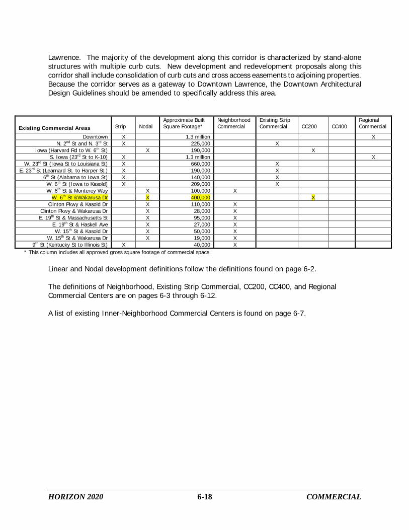
Existing Commercial Areas Strip
Nodal
Approximate Built Square Footage*
Neighborhood Commercial
Existing Strip Commercial
CC200
CC400
Regional Commercial
Downtown X 1.3 million X N. 2nd St and N. 3rd X St 225,000 X
Iowa (Harvard Rd to W. 6th St) X 190,000 X S. Iowa (23rd X St to K-10) 1.3 million X
W. 23rd X St (Iowa St to Louisiana St) 660,000 X E. 23rd X St (Learnard St. to Harper St.) 190,000 X
6th X St (Alabama to Iowa St) 140,000 X W. 6th X St (Iowa to Kasold) 209,000 X W. 6th St & Monterey Way X 100,000 X
W. 6th St &Wakarusa Dr X 400,000 X Clinton Pkwy & Kasold Dr X 110,000 X
Clinton Pkwy & Wakarusa Dr X 28,000 X E. 19th St & Massachusetts St X 95,000 X
E. 19th St & Haskell Ave X 27,000 X W. 15th St & Kasold Dr X 50,000 X
W. 15th St & Wakarusa Dr X 19,000 X 9th X St (Kentucky St to Illinois St) 40,000 X
* This column includes all approved gross square footage of commercial space.
Linear and Nodal development definitions follow the definitions found on page 6-2. The definitions of Neighborhood, Existing Strip Commercial, CC200, CC400, and Regional Commercial Centers are on pages 6-3 through 6-12. A list of existing Inner-Neighborhood Commercial Centers is found on page 6-7.

HORIZON 2020 6-19 COMMERCIAL
LAWRENCE - NEW COMMERCIAL AREAS All new commercial and office development shall occur in accordance with the plan recommendations. New commercial, retail and related uses shall be developed as a node with shared parking areas, common access drives, and related design and appearance. Nodes shall be positioned and oriented to the primary street intersections where they are located, avoiding a "strip" pattern as a result of extension of commercial uses along the streets from where the node originated. Commercial nodes include other important community services and facilities, such as satellite post offices, police, fire and emergency services, religious facilities, community centers and other services and institutions. Inclusion of these uses assists the integration of the commercial area into the overall neighborhood, serving multiple communities and service needs in a single location, and creating physically distinctive use areas apart from traditional commercial areas. The Comprehensive Plan includes recommendations for the location of new commercial development. As the community grows, it may be necessary to change the recommended location of a Commercial Center(s) or not use a designated intersection for a commercial uses. If there is a need to move the recommended location of a Commercial Center or downgrade the recommended size of a center, the Comprehensive Plan shall be amended. Through the amendment process, the proposed location and/or change in size of the Commercial Center will be reviewed based on the effects the change will have on infrastructure systems, the surrounding land uses, the neighborhood and the community-at-large. The Comprehensive Plan does not support increasing the size or number of new Commercial Centers, however small, new inner-neighborhood centers are possible and/or anticipated as part of an overall new planned neighborhoods. • Inner-Neighborhood Commercial Centers New Inner-Neighborhood Commercial Centers shall be allowed in very unique situations, such as when Center is part of an overall planned neighborhood development or can be easily integrated into an existing neighborhood. Inner-Neighborhood Commercial Centers are to be an amenity to the adjacent residents and serve only the immediate neighborhood. A new Inner-Neighborhood Commercial Center shall have no gas pumps, drive-thru or drive-up facilities. The Center shall be pedestrian oriented and have no more than 3,000 gross square feet of commercial space. The Center shall be located on a local, collector or arterial street. It may also take access from an alley. Inner-Neighborhood Commercial Center uses may include book stores, dry cleaning services, food stores, beauty salons, etc. Inner-Neighborhood Commercial Centers may also include residential uses. New Inner-Neighborhood Commercial Centers shall be designed as an integrated part of the surrounding neighborhood so that appearance of the commercial area does not detract from the character of the neighborhood. Horizon 2020 does not specifically indicate the location of new Inner-Neighborhood Commercial Centers due to their unique situations.

HORIZON 2020 6-20 COMMERCIAL
• Neighborhood Commercial Centers The Comprehensive Plan recommends the following intersections as potential locations for new Neighborhood Commercial Centers.
1. Franklin Road extended and E. 28th Street extended 2. E 1500 Rd and N 1100 Rd 3. E 1000 Rd and N 1000 Rd 4. E 1000 Rd and N 1200 Rd 5. Clinton Parkway and K-10 6. W. 15th
7. E 800 Rd and at the potential east/west arterial 1 mile north of US-40 Street and K-10
8. E 700 Rd and US-40 9. E 800 Rd and N 1500 Rd 10. E 1000 Rd and N 1750 Rd 11. E 1500 Rd and US Highway 24/40
These areas are all intended for development as small, compact commercial nodes that provide goods and services to the immediately adjoining neighborhood areas. They shall be developed in a manner that is consistent with the goals, policies and recommendations of the Comprehensive Plan. • Community Commercial Centers (CC200) The Comprehensive Plan recommends the following intersection as potential location for a new CC200 Centers.
1. E. 23rd
Street and O’Connell Road
• Community Commercial Centers (CC400) The Comprehensive Plan recommends the following intersections as potential locations for new CC400 Centers.
1. Eastern leg of the SLT and K-10 (southeast of the intersection of E 1750 Rd and K-10) 2. W. 6th
3. US-59 and N 1000 Rd Street and K-10
The development of these nodes shall carefully follow the commercial goals and policies. Commercial development shall not occur in advance of market conditions that would support such development, nor shall it be permitted to occur in a manner that is contrary to adopted city infrastructure plans. • Auto-Related Commercial Centers The Comprehensive Plan recommends the following intersections as potential locations for new Auto-Related Centers.
1. I-70 and K-10 2. US-59/40 and I-70

HORIZON 2020 6-21 COMMERCIAL
3. US-59 and K-10 • Regional Commercial Centers The need for development of a new Regional Commercial Center within the community is not anticipated within the planning period. Consideration of requests to expand existing commercial areas shall include the potential for development of additional Regional Commercial Centers and the impact of such expansion and development on the existing commercial inventory. The need for additional regional commercial development within the community shall be evaluated on a regular basis, based upon updated land use and population data. Before a new Regional Commercial Center is considered, the Comprehensive Plan shall be amended to include the possibility of a new Regional Commercial Center. UNINCORPORATED DOUGLAS COUNTY - EXISTING COMMERCIAL AREAS Unincorporated Douglas County currently maintains a variety of commercial areas. Each of these areas provides neighborhood level retail goods and services to both farm and non-farm residents. As the rural areas of Douglas County continue to receive new non-farm residential development, demands will increase for retail goods and services. It is recommended that these commercial locations be developed as small convenience service nodes, providing products to meet the day-to-day requirements of rural residents. The development of these nodes shall follow the basic principles described for commercial development or redevelopment. It is important that these commercial locations provide for adequate wastewater treatment facilities in the future. Any new or expanded developments shall utilize treatment systems that minimize potential environmental impacts. The design of these locations should be consistent with the rural character of Douglas County. Therefore, design and development standards should promote larger, more spacious settings and encourage building and site design reflective of the unique characteristics surrounding each location. UNINCORPORATED DOUGLAS COUNTY - NEW COMMERCIAL AREAS Commercial locations in both unincorporated Douglas County and Douglas County communities together provide reasonable accessibility in terms of distance and the type of goods and services available. As Douglas County continues to urbanize, the need for additional commercial space in the unincorporated portions of Douglas County will increase. New commercial areas shall not be located within a four mile radius of any existing commercial area. There are already a number of existing commercially zoned areas in the unincorporated portions of Douglas County. Most of these locations are well placed at the intersection of a hard surfaced County Route and a state or federally designated highway. Areas that are already zoned commercially and are located at the intersection of a hard surfaced county route and state or federally designated highway should be expanded to serve any increased demand for commercial space in the county. The Comprehensive Plan recommends that only one new commercial area be created in the unincorporated portion of the county. The southeastern area of the county does not have any commercially zoned areas. To serve this area a commercial development could be located at the intersection of US-56 and K-33 or US-56 and County Route

HORIZON 2020 6-22 COMMERCIAL
1061. A limiting factor to the size of any commercial development in unincorporated Douglas County will be the availability of utilities, particularly water and sanitary sewer. Any on-site treatment system shall be designed to minimize its impacts on the environment. The amount of gross square footage of a commercial development shall be limited to a total of 15,000 gross square feet to serve the surrounding rural area.
Commercial activities related to conference, recreational, or tourism uses associated with Clinton Lake, Lone Star Lake, or Douglas County Lake shall be exempt from the locational criteria applied to new commercial areas or expansions of existing commercial areas. A commercial area serving the recreational needs (boat rental, bait shop, lodging, etc.) of persons using the county’s lake facilities may be located at an entrance point to a lake. Conference, recreational, or tourism uses located in the Rural Area, and which include some significant level of urban development, shall satisfy the criteria listed in Chapter Four. Such uses shall also include a mandatory minimum 200’ natural buffer area or other appropriate distance as determined by the Board of County Commissioners. Proposed conference, recreational, or tourism facilities shall include a site specific site plan with rezoning applications to demonstrate that the criteria listed in Chapter 4, and the 200’ buffer area, have been met.

HORIZON 2020 6-23 COMMERCIAL
COMMERCIAL LAND USE GOALS AND POLICIES
Guidelines are needed to allow for the retention and expansion of the established commercial areas of the community.
GOAL 1: Established Commercial Area Development
Encourage the retention, redevelopment and expansion of established commercial areas of the community.
Policy 1.1: Recognize and Emphasize Downtown Lawrence as the Regional
Retail/Commercial/Office/Cultural Center
A. Encourage and support the development of a broad mix of land uses, with an emphasis on retail as a major land use, the provision of parking facilities, improved accessibility, and the expansion of Downtown Lawrence while maintaining the integrity of surrounding neighborhoods.
B. Strengthen, define and support neighborhood residential areas adjacent to
Downtown Lawrence in order to reinforce the safety, image and identity of Downtown Lawrence.
C. Closely analyze (through Policies 1.7, 3.7 G, 3.9 E, and any other relevant Policies)
the impact of requests for development of community and/or regional shopping areas to ensure that such development does not have a negative impact on the Regional Retail/Commercial/Office/Cultural Center. This analysis would be used to evaluate the potential impact on the future viability of the Regional Retail/Commercial/Office/Cultural Center as a whole and not the potential impact on individual businesses or properties.
Policy 1.2: Sustain Downtown Lawrence as a Mixed Use Activity Center
Continue to encourage a broad mix of uses in Downtown Lawrence, including retail, office, residential, entertainment, lodging, unique visitor attractions, expanded conference facilities, a core concentration of governmental, cultural and social facilities and services, as well as recreation, leisure and community events.
Policy 1.3: Assure Compatibility of Development
A. Encourage new development and redevelopment to consider horizontal and vertical proportions, building forms, roof types, and exterior materials and details existing in the surrounding area.
B. New development and redevelopment shall conform to the applicable adopted design guidelines.

HORIZON 2020 6-24 COMMERCIAL
Policy 1.4: Redevelopment of Existing Commercial Areas
A. Existing commercial areas should be improved and upgraded. Particular emphasis should be given to existing commercial gateways. Overall storm water management, vehicular and pedestrian access, and site maintenance shall be undertaken.
B. Upgrade the image and appearance of existing developments with new lighting,
landscaping, signage and pedestrian access. C. Encourage public and/or private partnerships for redevelopment. D. Consider financial and development incentives to encourage re-use (renovation or
redevelopment) of commercial properties. Policy 1.5: Provide Opportunities for Limited Commercial Development in the
Unincorporated Areas of Douglas County
A. Encourage redevelopment and limited expansion of existing commercial areas in the unincorporated areas of Douglas County.
B. No new commercial development shall occur within the UGA.
Policy 1.6: Maintain an Inventory of Commercial Land
Maintain an appropriate supply of commercially zoned land so that site choices are available and infrastructure expansion can occur in an efficient and orderly manner. Annually evaluate current and approved planned land uses and land availability. The evaluation shall consider, but not be limited to: approved planned development not yet constructed, compatibility with existing nearby development, parcel size and infrastructure service delivery and phasing plans.
Policy1.7 Monitor Economic Impact of Commercial Growth
A. The amount of commercial space, the quality of commercial space, commercial space vacancy rates, and the size of commercial space shall be monitored for each quadrant of the city (15th
Street shall be the north-south dividing line and Iowa Street the east-west dividing line). Each matrix cell shall include the total gross square footage of all the buildings in each respective size range and condition grade. Each cell shall also include the vacancy rate for buildings of each respective size and condition.
B. These variables shall be placed in a matrix and used in analyzing any commercial rezoning request and/or development plan.
C. The matrix shall be updated annually. D. Planning Staff shall be responsible for maintaining and revising the matrix. However

HORIZON 2020 6-25 COMMERCIAL
some of the data for some of the variables, particularly vacancy rates, may have to be provided by outside sources.
E. Planning Staff will provide an annual sales tax per square foot ratio. This data will
be provided for different sectors within the city limits. F. Establish and implement a methodology for the annual collection of business use
data in support of economic impact analyses.

HORIZON 2020 6-26 COMMERCIAL
Matrix
Condition of the Commercial Space Excellent Good Fair Poor Total
0 - 2,500 Sq. Ft. total sq. ft./vacancy rate
total sq. ft./vacancy rate
total sq. ft./vacancy rate
total sq. ft./vacancy rate
total sq. ft./vacancy rate
2,501 - 5,000 total sq. ft./vacancy rate
total sq. ft./vacancy rate
total sq. ft./vacancy rate
total sq. ft./vacancy rate
total sq. ft./vacancy rate
5,001 - 15,000 total sq. ft./vacancy rate
total sq. ft./vacancy rate
total sq. ft./vacancy rate
total sq. ft./vacancy rate
total sq. ft./vacancy rate
15,001 - 30,000 total sq. ft./vacancy rate
total sq. ft./vacancy rate
total sq. ft./vacancy rate
total sq. ft./vacancy rate
total sq. ft./vacancy rate
30,001 - 60,000 total sq. ft./vacancy rate
total sq. ft./vacancy rate
total sq. ft./vacancy rate
total sq. ft./vacancy rate
total sq. ft./vacancy rate
60,001 - 120,000
total sq. ft./vacancy rate
total sq. ft./vacancy rate
total sq. ft./vacancy rate
total sq. ft./vacancy rate
total sq. ft./vacancy rate
120,001 - 200,000
total sq. ft./vacancy rate
total sq. ft./vacancy rate
total sq. ft./vacancy rate
total sq. ft./vacancy rate
total sq. ft./vacancy rate
200,001 + total sq. ft./vacancy rate
total sq. ft./vacancy rate
total sq. ft./vacancy rate
total sq. ft./vacancy rate
total sq. ft./vacancy rate
Total total sq. ft./vacancy rate
total sq. ft./vacancy rate
total sq. ft./vacancy rate
total sq. ft./vacancy rate
total sq. ft./vacancy rate
The above matrix will be completed for each quadrant of the city, plus an additional table summarizing the totals for the entire city.

HORIZON 2020 6-27 COMMERCIAL
Guidelines are needed to allow for a compatible transition from commercial development to residential neighborhoods and other less intensive land uses. These guidelines are needed throughout the community, including both established commercial areas and anticipated development areas.
GOAL 2: Compatible Transition from Commercial Development to Less Intensive
Uses Ensure compatible transition from commercial development to residential neighborhoods and other less intensive land uses.
Policy 2.1: Use Appropriate Transitional Methods
A. Commercial areas shall minimize adverse impacts on adjacent residential areas. Screening and buffering shall be provided which may include landscaped setbacks, berms and open space areas. Traffic and parking shall not adversely affect neighborhood quality. Noise, safety and overall maintenance of commercial properties shall be carefully monitored.
B. Use landscaped transition yards between residential and non-residential uses that
include additional lot depth, berms, landscape screening, and/or fences and walls to provide additional buffering between differing land use intensities.
C. Compatible transition from commercial uses to less intensive land uses shall
consider:
1. Site Orientation
a. Vehicular access shall be from collector, arterial or access streets.
b. Pedestrian access shall be designed to provide internal and external circulation from adjacent neighborhoods.
c. Streets designed with elements to provide visual or physical buffering
may serve as boundaries between different intensities of land uses.
2. Building Relationships
a. A back-to-back relationship is preferable between uses.
b. Commercial buildings and parking lots shall not have lesser setbacks than those required of abutting residential uses.
c. The height and massing of commercial buildings and accessory
structures shall be oriented to avoid creating a negative visual effect on residential neighborhoods.

HORIZON 2020 6-28 COMMERCIAL
d. Vehicular access to commercial activities should be separated from pedestrian access.
3. Land Features
a. Encourage the integration of mature trees, natural vegetation, and
natural and environmentally sensitive areas whenever feasible to buffer commercial developments from other more or less intensive land uses.
b. Encourage the use of existing topography to separate commercial
developments and other more or less intensive land uses.
4. Screening and Landscaping
a. Encourage creative and extensive use of landscaping and berming techniques for natural transitions between differing intensities of land uses.
b. Fences shall not be used as a sole method of providing screening
and buffering between differing intensities of land uses.
c. Encourage site design that uses existing vegetation, such as stands of mature trees, as natural buffers or focal points.
d. Encourage the use of high quality materials in the construction of
screening and landscape areas to decrease long-term maintenance costs.
5. Lighting
a. Lighting used to illuminate parking areas, signs or structures should
be placed to deflect light away from adjoining properties or public streets through fixture type, height and location.
Policy 2.2: Locate Less Compatible Uses Toward the Interior of Commercial Areas
A. The overall design and arrangement of commercial development shall be compatible with adjacent residential uses.
B. Ensure adequate screening of unsightly views of commercial developments (such as
loading docks, rooftop equipment, service entrances, trash containers, parking areas, exterior storage) through the extensive use of elements such as landscaping, berms, fencing, architectural design, open space, setbacks, and/or building orientation.
C. In order to ensure that parking lots are not the dominant visual feature associated
with commercial areas, buildings shall be located adjacent to the public rights-of-way and parking located toward the interior of the development.

HORIZON 2020 6-29 COMMERCIAL
Policy 2.3: Higher-Density Residential Development as Transitional Use
Use higher-density residential development as a transitional land use between commercial developments and the surrounding low-density residential neighborhoods.
Policy 2.4: Provide Sufficient Site Area for the Design of Transitional Elements
Site improvements within commercial areas such as lighting, signage and landscaping shall be designed and coordinated in order to create a positive identity and visual image throughout the development area.
Policy 2.5: Office, Research and Semi-Public Development as Transitional Use
A. Encourage using low-intensity office, research and semi-public development as a transition between commercial development and low-density residential neighborhood. The development shall include:
1. Design elements such as height, massing, and scale compatible with the
surrounding low-density residential uses;
2. Site design that is compatible with surrounding residential neighborhoods with consideration given to extensive screening, building and parking orientation, and preservation of natural site amenities; and
3. Site access provided from arterial, collector or access streets, with traffic
directed away from surrounding residential areas. Policy 2.6: Parks, Recreation and Open Space as Transitional Use
Encourage the use of medium- to low-intensity recreational facilities such as neighborhood parks, bike/hike trails and natural areas as transitional areas.

HORIZON 2020 6-30 COMMERCIAL
Guidelines are needed to provide direction on how much, where and at what scale commercial development is appropriate for the market it is intended to serve.
GOAL 3: Criteria for Commercial Development
Provide regional, community and neighborhood shopping opportunities to meet the commercial and retail needs of the community.
Policy 3.1: Utilize Locational Criteria for Commercial Development
A. Commercial Nodes: Nodes shall occur at arterial/collector or arterial/arterial intersections depending on the type of commercial center.
B. Strip Commercial Development: Stop the formation or expansion of Strip
Commercial Development by directing new development in a more clustered pattern.
C. Assembling of Land: Encourage the assembling of small tracts to form larger, more cohesive parcels to enable well-planned and orderly development to occur.
D. Vehicular Access: Limit the principal vehicular access of commercial development
to arterial, collector or frontage (access) streets.
E. Site Layout: Commercial development shall be located to avoid substantial disruption of natural drainage and vegetation.
F. Compatibility with Adjacent Land Uses: Encourage the location of commercial
nodes where they can efficiently utilize local resources, where their adverse impacts on adjacent uses are minimized, and where they will effectively provide the community with desired products, services and employment opportunities.
G. Public Improvements: Construction of a new commercial center cannot begin
until all infrastructure improvements serving the center have been completed.
Policy 3.2: Establish Design Standards for Commercial Development
A. The city shall develop reasonable design standards for new and redeveloped commercial areas which improve:
1. Integration with the surrounding neighborhoods; 2. Pedestrian movement to and within the commercial areas; 3. The aesthetics of the districts from the surrounding street system; and 4. The design to create attractive focal points for the surrounding
populations.
B. Incentive systems shall be developed to encourage commercial areas to provide mixed use projects that include residential and office uses integral to the design.

HORIZON 2020 6-31 COMMERCIAL
C. These design standards and incentives shall be adopted into HORIZON 2020 and
implemented through zoning, subdivision and the Capital Improvements Plan. Policy 3.3: Criteria for Inner-Neighborhood Commercial Centers
A. Encourage redevelopment of existing Inner-Neighborhood Commercial Centers through alternative standards for:
1. Required parking; 2. Open space requirements; 3. Required setbacks; and 4. Required lot size.
B. Do not encourage the expansion of existing Inner-Neighborhood Commercial
Centers. C. Inner-Neighborhood Commercial Centers may be located on local, collector, or
arterial streets. They may also take access from an alley. D. Standards for New Inner-Neighborhood Commercial Centers:
1. Inner-Neighborhood Commercial Centers shall be allowed only in those
situations where the center is an integral part of an overall planned neighborhood or if the Center can be integrated into an existing neighborhood;
2. Centers shall not have gas pumps, drive-thru or drive-up facilities; 3. Centers may include residential uses; 4. Centers shall no more than 3,000 gross square feet of commercial space;
and 5. Centers shall be designed as an integrated part of the surrounding
neighborhood so that their appearance does not detract from the character of the neighborhood.
Policy 3.4: Criteria for Mixed-Use Redevelopment Centers
A. Encourage redevelopment of areas where existing structures are underutilized, have experienced a high turnover rate, or have remained vacant for an extended period of time.
B. Mixed-Use Redevelopment Centers shall be no larger than six acres in size. C. Mixed-Use Redevelopment Centers shall include a mix of the following uses
within the subject area and where possible, include mixed-use structures:
1. Residential; 2. Civic; 3. Office; 4. Small-scale commercial:

HORIZON 2020 6-32 COMMERCIAL
a. Total commercial spaces shall not exceed 25% of the net floor area within the subject area, and
b. A single retail space shall not occupy more than 16,000 square feet of ground-floor level, net floor area of a structure; and
5. Open space.
D. Mixed-Use Redevelopment Centers shall maintain the character of the surrounding neighborhoods by:
1. Achieving integration with adjacent land uses by providing transitions
between uses through alleyways and use and landscape buffers; 2. Incorporating existing structures wherever possible; 3. Maintaining general structure spacing, massing, scale, and street frontage
relationship when incorporating new structures.
E. Mixed-Use Redevelopment Centers shall provide multi-modal services to include the following options:
1. Pedestrian, including pedestrian-scaled street furnishings, plantings and
gathering spaces; 2. Bicycle, including bicycle parking; 3. Vehicular; and 4. Transit, if available.
Policy 3.5: Criteria for Neighborhood Commercial Centers
A. Neighborhood Commercial Centers shall be located at the arterial/arterial or arterial/collector street intersections.
B. Limit the commercial uses in neighborhood centers to one corner of the intersection. C. New Neighborhood Commercial Centers shall be at least one (1) mile from any
existing or new Commercial Center.
D. Neighborhood Commercial Centers shall contain no more than 100,000 gross square
feet of commercial space with the exception of Neighborhood Commercial Centers that include a grocery store. Neighborhood Commercial Centers with a grocery store of 60,001 or more gross square feet may have up to a total of 125,000 gross square feet of commercial space.
E. No one commercial use in a Neighborhood Commercial Center shall occupy an area
larger than 40,000 gross square feet. The only exception is a grocery store, which may occupy an area up to 80,000 gross square feet.
F. A nodal plan shall be completed before a proposal for a Neighborhood Commercial
Center goes before the Planning Commission.
G. Locate office, public, semi-public, parks and recreation or medium- and higher-

HORIZON 2020 6-33 COMMERCIAL
density residential developments on remaining corners of intersection to avoid excessive concentrations of commercial traffic and unnecessary duplication of commercial services.
H. Low-density residential uses may be located at the remaining corners of the intersection if sufficient screening measures are provided to offset noise and views of the intersection are provided.
I. Integrate neighborhood commercial centers into the surrounding residential neighborhoods by including pedestrian access, appropriate transitional elements and, if possible, the location of public or semi-public uses or parks and recreation uses adjacent to the commercial development.
J. Neighborhood Commercial Centers shall be designed with pedestrian mobility as a
top priority.
1. Pedestrians shall be able to easily walk to all stores in a neighborhood center without using a vehicle.
2. Parking lots shall provide pedestrian accessways to reduce the potential of
pedestrian/vehicle conflicts.
K. Façades shall have a variety of textures, colors, shapes, etc. such that the buildings in a Neighborhood Center do not have a single uniform appearance.
L. Neighborhood Centers should have dedicated open space areas that useable by the
Center’s employees and shoppers. M. Neighborhood Commercial Centers shall not expand into the surrounding portions of
the neighborhood. N. Any commercial development proposal for a corner in a new Neighborhood
Commercial Center shall have a length-to-depth ratio between 1:1 and 3:2. O. Neighborhood Commercial Centers shall develop in a manner that is consistent with
the city’s adopted design guidelines. Policy 3.6: Criteria for Existing Strip Commercial areas
A. A redevelopment plan should be made for each existing Strip Commercial Center B. Tools such as public/private partnerships, special overlay districts, reduced
development standards, lot consolidation and purchase, access management plans, cross access easements, etc. should be used to enhance redevelopment opportunities for existing Strip Commercial areas.
C. Existing Strip Commercial areas shall not expand into surrounding lower-intensity
zoning areas.

HORIZON 2020 6-34 COMMERCIAL
D. Curb cut consolidation and cross access easements shall be included when an existing site plan is revised or a new site plan proposed.
E. Existing Strip Commercial areas shall develop or redevelop in a manner consistent
with the city’s adopted design guidelines. Policy 3.7: Criteria for Community Commercial Centers (under 200,000 square feet)
CC200
A. CC200 Centers shall be located at the intersection of arterial/arterial streets. B. CC200 Centers shall have no more than 200,000 gross square feet of commercial
space. C. No single store shall occupy more than 100,000 gross square feet. D. A general merchandise store (including discount and apparel stores) shall not
exceed 65,000 gross square feet. E. The sum of the gross square footage for all stores occupying space between 40,000
and 125,000 shall not be more than 75 percent of gross commercial square footage for the corner of the intersection.
F. Corners of the node not developed with commercial uses shall have extensive on-
site screening and shall be utilized for office, employment-related, public and semi-public, parks and recreation, and higher-density residential uses. Encourage the development of mixed-use centers (office, employment-related uses, public and semi-public uses) adjacent to community commercial development to provide mutual attraction to employees and retailers and to enhance the visual image of the area.
G. New or existing CC200 Centers shall not encroach or expand into the surrounding
residential or lower-intensity uses.
H. A proposal requiring a revised or new site plan for property in a CC200 Center shall include plan for reducing curb cuts, providing cross access easements to adjacent properties, and buffering for adjacent non-commercial uses.
I. A nodal plan shall be completed before proposals for the redevelopment or
expansion of an existing CC200 Center that include more than 50 percent of the existing gross commercial square footage or plans to expand the center by more than 20 percent go before the Planning Commission.
J. Proposals for the redevelopment or expansion of an existing CC200 Center that
include more than 50 percent of the existing gross commercial square footage or plans to expand the center by more than 20 percent shall include a building with at least 40,000 gross square feet of commercial space.
K. A nodal plan shall be completed before a proposal for a new CC200 Center goes

HORIZON 2020 6-35 COMMERCIAL
before the Planning Commission. L. Proposals for a new CC200 Center shall include a building with at least 40,000 gross
square feet of commercial space. M. CC200 Centers shall develop or redevelop in a manner that is consistent with the
city’s adopted design guidelines. Policy 3.8: Criteria for Community Commercial Centers (under 400,000 square feet)
CC400
A. CC400 Centers shall be located at the intersection of two arterial streets that both have at least a four lane cross-section or the intersection of a four-lane arterial and a state or federally designated highway.
B. CC400 Centers must be a minimum of 3.75 miles apart. C CC400 Centers shall have a maximum of 400,000 gross square feet of commercial
space. D. At least 95 percent of the commercial gross square footage in a new CC400 Center
shall be located on two corners of the intersection. The remaining five percent shall be located on one of the remaining two corners.
E. No single store in a CC400 Center shall occupy more than 175,000 gross square
feet. F. The sum of the gross square footage for all stores occupying between 100,000 and
175,000 cannot be more than 70 percent of the gross commercial square footage for the corner of the intersection.
G. If the proposal for a corner of the intersection includes more than 100,000 gross
square feet of commercial space, the proposal shall include a single building that has at least 40,000 gross square feet of commercial space.
H. Proposals in which the commercial gross square footage is less than ten percent of
the total square footage of the project do not have to meet the minimum acreage and lot depth.
I. Any commercial development proposal for a single corner in a new CC400 Center
shall be a minimum of 20 acres in size. J. Any commercial development proposal for a single corner in a new CC400 Center
shall have a length-to-depth ratio between 1:1 and 3:2. K. Access points into a new CC400 Center shall be from the two points furthest from
the intersection. L. CC400 Centers shall be designed with feeder and/or reverse frontage streets to
HORIZON 2020 6-36 COMMERCIAL
collect internal traffic and for easy access from the surrounding community. M. CC400 Centers shall be designed with pedestrian mobility as a top priority.
1. Centers shall be designed to facilitate the movement of pedestrians from store to store and building to building.
2. Parking lots shall provide pedestrian accessways to reduce the potential of
pedestrian/vehicle conflicts.
O. Facades shall have a variety of textures, colors, shapes, etc. such that the buildings in a CC400 Center do not have a single uniform appearance.
P. CC400 Centers should have dedicated open space areas that useable are by the
center’s employees and shoppers. Q. Buildings shall not be separated from adjacent street rights-of-way by large
expanses of parking. R. Corners of the node that are not developed with commercial uses should be utilized
for office, employment-related, public and semi-public, parks and recreation, and higher-density residential uses with extensive on-site screening. Encourage the development of mixed-use centers (office, employment-related uses, public and semi-public uses) adjacent to community commercial development to provide mutual attraction to employees and retailers and to enhance the visual image of the area.
S. Existing CC400 Centers shall not expand into areas with existing less intensive uses
(low-intensity residential, institutional uses, office, multi-family residential, etc.). T. A nodal plan must be completed before a development proposal for any corner of
CC400 Center is forwarded to the Planning Commission. U. CC400 Centers shall develop in a manner that is consistent with the city’s adopted
design guidelines. Policy 3.9: Nodal Plan Criteria
A. The city should attempt to complete a nodal plan for newly designated Commercial Center before there is pressure to develop the node.
B. A nodal plan shall be completed for any new Commercial Center before a
development proposal for the node can go before the Planning Commission. C. A nodal plan shall include the following information:
1. Existing natural features; 2. Appropriate transitional uses; 3. Appropriate use for each specific corner of the intersection;

HORIZON 2020 6-37 COMMERCIAL
4. Access points from each location; 5. Necessary infrastructure improvements; 6. Overall traffic flow in and around the node and the surrounding area; 7. The “ultimate geometric design” for the intersection based on the proposed
land uses for the intersection; and 8. Any and all other necessary information needed to create the nodal plan.
Policy 3.10: Criteria for the Regional Retail/Commercial/Office/Cultural Center
A. Recognize and emphasize Downtown Lawrence as the Regional Retail/Commercial/Office/Cultural Center -- which is an intensely developed, large-scale, mixed use location that serves as an activity center for the community.
B. Continue to encourage a broad mix of uses in downtown Lawrence, including retail,
office, residential, entertainment, lodging, unique visitor attractions, expanded conference facilities. Maintain the core concentration of governmental, cultural/social facilities and services and recreation, leisure and community events in this area.
C. Encourage the continuation of community social activities (Art in the Park, holiday
parades, etc.) to occur in Downtown Lawrence. D. Continue to support the building design criteria set forth in the “Downtown
Architectural Design Guidelines”. E. The “Downtown Architectural Design Guidelines” should be amended to include the
W. 9th
Street area that serves as a gateway into Downtown Lawrence.
F. Maintaining and protecting the vitality of Downtown Lawrence is important to the citizens of Lawrence. Because of its high importance as an asset to the community, any new proposal for a new Regional Commercial Center must demonstrate that it will not have a substantial impact on Downtown Lawrence.
Policy 3.11: Criteria for Regional Commercial Centers
A. The Comprehensive Plan does not anticipate the need for a new Regional Commercial Center within the planning period.
B. Designating a new Regional Commercial Center will require an amendment to the
Comprehensive Plan. C. Design Criteria
1. The commercial development plan for a corner shall have a minimum of 40 acres;
2. The development shall have a minimum of 1,400 linear feet of frontage on a public street;
3. A Regional Commercial Center shall not have more than 1.5 million gross

HORIZON 2020 6-38 COMMERCIAL
square feet of commercial space; and 4. A Regional Commercial Center shall be located at the intersection of two
state or federally designated highways or the intersection of an arterial street and a state or federally designated highway.
D. A nodal plan shall be completed before a development proposal for a Regional
Commercial Center is forwarded to the Planning Commission. F. Parking lots shall be designed to minimize conflicts between pedestrians and
vehicles. G. Centers shall be designed to facilitate the movement of pedestrians from store to
store and building to building. H. Buildings shall be placed near adjacent street right-of-way. I. The majority of parking for the center shall be behind the front building line.
J. A proposal requiring a revised or new site plan for property in an existing Regional
Commercial Center shall include a plan for reducing curb cuts, providing cross access easements to adjacent properties, and buffering for adjacent non-commercial uses.
K. New or existing Regional Commercial Centers shall not intrude or expand into the
surrounding residential or lower-intensity uses. L. CC400 Centers shall develop in a manner that is consistent with the city’s adopted
design guidelines. Policy 3.12: Criteria for Commercial Development in Unincorporated Areas
A. Existing commercial areas that are located at the intersection of a hard surfaced County Route and a state or federally designated highway should be allowed to expand if the necessary infrastructure (water, road, approved wastewater treatment facility, etc.) is available.
B. Encourage new commercial development at key access points on major corridors
only if served by adequate infrastructure, community facilities and services.
C. The commercial gross square footage of a development shall be limited to a total of 15,000 gross square feet.
D. The only new commercial area shall be located at the intersection of either US-56
and K-33 or US-56 and County Route 1061. Policy 3.13: Require a Market Impact Analysis
A. Proposals to create any shopping district that, when considering the entire node, will result in greater than 150,000 gross square feet of commercial building space shall

HORIZON 2020 6-39 COMMERCIAL
include an independent market analysis. Initial development proposals of 50,000 gross square feet or less on any single corner are exempt from this market analysis requirement, but will be limited to one exemption per corner of the intersection. The market analysis shall adhere to all of the following criteria:
1. The entity proposing the commercial project shall provide the funding of
the study. 2. The independent consultant that performs the market study shall be
chosen by the city and agreed upon by the entity submitting the proposal for the shopping center.
3. The study shall analyze the commercial proposal and provide at least the
following information:
a. The overall viability of the proposal; b. The validity of the proposal considering any community retail
vacancy, sales/square foot and square footage/capita data as outlined in Policy 1.7;
c. How the proposal will impact existing commercial development in the community;
d. How the mix and sizes of proposed uses of the development will impact the viability of Downtown Lawrence;
e. A building phasing schedule based upon the community’s ability to absorb the additional commercial square footage; and
f. Any other additional information required by the Planning Commission.
B. The project shall not be approved if the market study indicates the commercial
project or any proposed phase cannot be absorbed into the community within three years from the date of its estimated completion, or that it would result in a community-wide retail vacancy rate of greater than eight percent.
Policy 3.14: Criteria for Mixed-Use Districts
A. Encourage preservation of areas that are mixed use in nature, as well as development and redevelopment of areas with vacant land, or where existing structures are underutilized, have experienced a high turnover rate, or have remained vacant for an extended period of time.
B. Mixed-Use Districts shall be no larger than 20 acres in size.
C. Mixed-Use Districts shall include a mix of the following uses within the subject
area and where possible, in mixed-use structures: a. Residential; b. Non-residential.

HORIZON 2020 6-40 COMMERCIAL
D. Mixed-Use Districts shall maintain the character of the surrounding neighborhoods by:
a. Achieving integration with adjacent land uses by providing transitions through alleyways, variation among development intensity, and implementation of landscape buffers;
b. Incorporating existing structures wherever possible; c. Maintaining general structure spacing, massing, scale, and street
frontage relationship when incorporating new structures.
E. Mixed-Use Districts shall provide multi-modal services to include the following options:
a. Pedestrian oriented public spaces, which shall include pedestrian-
scaled street furnishings, and plantings; b. Bicycle, including bicycle parking; c. Vehicular; and d. Transit.

HORIZON 2020 6-41 COMMERCIAL
Traffic impacts continue to be a major concern in commercial developments. Ensure safe and efficient access and circulation within and around commercial areas.
GOAL 4: Transportation Considerations
Promote a multi-modal transportation system that provides or improves access and circulation within and adjacent to commercial areas.
Policy 4.1: Levels of Service
The expansion of existing or new commercial development shall not occur until the surrounding street system can provide an acceptable level of service.
Policy 4.2: Evaluate Traffic Impacts
An evaluation of the traffic impacts of a development on the surrounding area shall consider the existing and projected traffic conditions in relation to the existing transportation system. This evaluation should be based on planned improvements identified in the Capital Improvement Plan (CIP), the Comprehensive Plan, and/or the Long-Range Transportation Plan. These plans shall be updated periodically to recognize changes in priorities and to add new projects with designated priorities.
Policy 4.3: Minimize Traffic Diversion
A. Prohibit direct vehicular access from commercial developments to local residential streets.
B. Discourage commercial traffic through residential neighborhoods.
Policy 4.4: Ensure Adequate Ingress and Egress
A. Limit the principal access of commercial development to arterial, collector or access/frontage streets.
B. Develop ways to improve access to downtown and other commercial centers within
the community through improved bike and pedestrian paths, bus access (loading/unloading) and parking areas, public transportation, and vehicular access.
Policy 4.5: Limit Access
A. Minimize curb cuts along arterial and collector streets.
B. Encourage shared access between adjacent commercial developments and coordinated traffic circulation within proposed development areas.

HORIZON 2020 6-42 COMMERCIAL
C. Lot access and street configurations shall be designed to avoid curb cuts and local street intersections on arterial streets and to coordinate access with adjacent developments.
Policy 4.6: Provide Vehicular Circulation
A. Development proposals shall provide adequate internal circulation within commercial developments that allows access to adjacent commercial buildings and commercial or mixed-use centers.
B. Development proposals shall ensure that vehicular circulation related to a specific
proposal does not rely on public streets for internal traffic circulation needs but provides circulation within the development.
Policy 4.7: Provide Pedestrian Access
A. The city should develop a pedestrian/bicycle pathway system that provides access from the University of Kansas campus to Downtown Lawrence.
B. Development proposals should provide safe, convenient pedestrian access to
concentrated retail areas from parking areas.
C. Development proposals should include sidewalks on one side of local streets (public and private) and both sides of collector and arterial streets.
D. Development proposals should include pedestrian access linking developments to
neighborhoods while ensuring physical separation from vehicles along both public and private streets and within parking areas.
E. Development proposals shall give consideration to providing a safe, reasonable
method for pedestrian access across major intersections. Policy 4.8: Provide Bicycle Access
A. Commercial development proposals should provide for interior bicycle access.
B. The city should develop a plan to provide bicycle links between major activity generators within the community.
Policy 4.9: Encourage Convenient Parking within Commercial Areas
A. Development proposals shall provide convenient parking for retail areas.
B. The city and property owners should work together to develop convenient parking for short-term visitors and long-term parking areas for employees.
Policy 4.10: Utilize Outlying Parking Lots
Identify potential parking areas which can serve mass transit and carpooling.

HORIZON 2020 6-43 COMMERCIAL
Policy 4.11: Ensure Adequate Truck Loading and Maneuvering Areas
Development proposals shall provide adequate loading space within a building or a side or rear yard, designed in such a way that all storage, standing and maneuvering of trucks will take place solely on private property.

HORIZON 2020 6-44 COMMERCIAL