Homework 6: Ocean Currents - UMass D · 14 August 20087 MAR 110 HW6 Ocean Currents 1 Homework 6:...
10
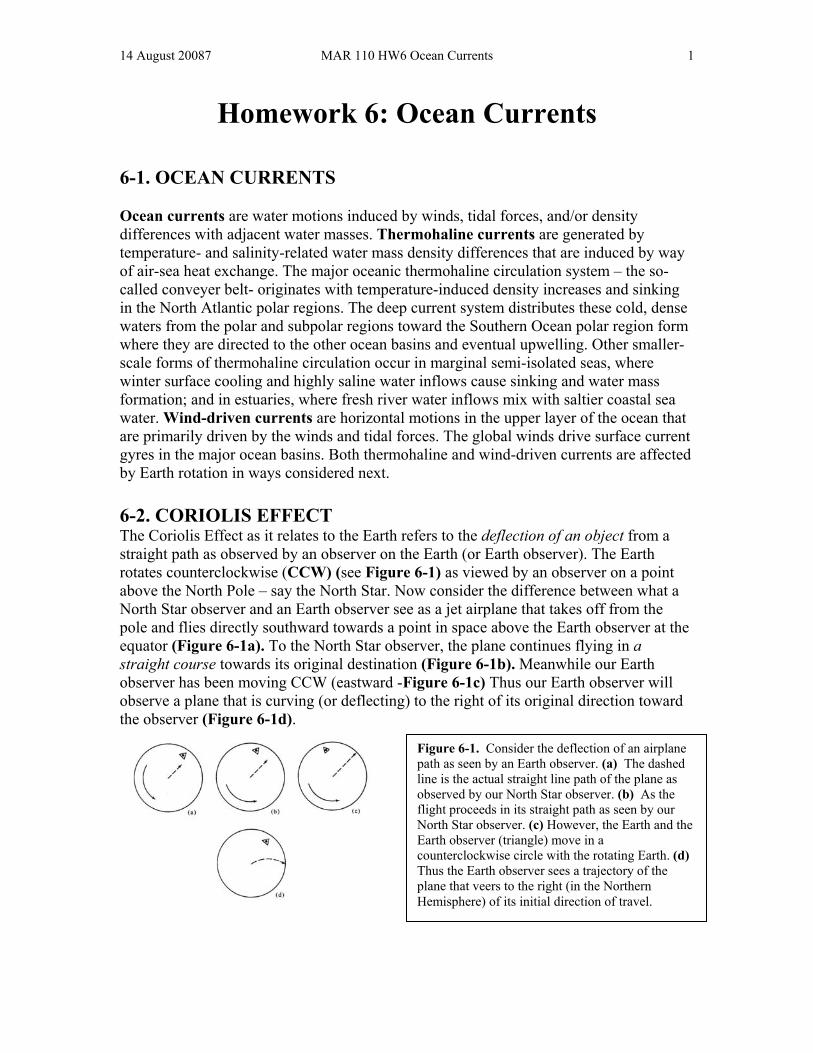
14 August 20087 MAR 110 HW6 Ocean Currents 1 Homework 6: Ocean Currents 6-1. OCEAN CURRENTS Ocean currents are water motions induced by winds, tidal forces, and/or density differences with adjacent water masses. Thermohaline currents are generated by temperature- and salinity-related water mass density differences that are induced by way of air-sea heat exchange. The major oceanic thermohaline circulation system – the so- called conveyer belt- originates with temperature-induced density increases and sinking in the North Atlantic polar regions. The deep current system distributes these cold, dense waters from the polar and subpolar regions toward the Southern Ocean polar region form where they are directed to the other ocean basins and eventual upwelling. Other smaller- scale forms of thermohaline circulation occur in marginal semi-isolated seas, where winter surface cooling and highly saline water inflows cause sinking and water mass formation; and in estuaries, where fresh river water inflows mix with saltier coastal sea water. Wind-driven currents are horizontal motions in the upper layer of the ocean that are primarily driven by the winds and tidal forces. The global winds drive surface current gyres in the major ocean basins. Both thermohaline and wind-driven currents are affected by Earth rotation in ways considered next. 6-2. CORIOLIS EFFECT The Coriolis Effect as it relates to the Earth refers to the deflection of an object from a straight path as observed by an observer on the Earth (or Earth observer). The Earth rotates counterclockwise (CCW) (see Figure 6-1) as viewed by an observer on a point above the North Pole – say the North Star. Now consider the difference between what a North Star observer and an Earth observer see as a jet airplane that takes off from the pole and flies directly southward towards a point in space above the Earth observer at the equator (Figure 6-1a). To the North Star observer, the plane continues flying in a straight course towards its original destination (Figure 6-1b). Meanwhile our Earth observer has been moving CCW (eastward -Figure 6-1c) Thus our Earth observer will observe a plane that is curving (or deflecting) to the right of its original direction toward the observer (Figure 6-1d). Figure 6-1. Consider the deflection of an airplane path as seen by an Earth observer. (a) The dashed line is the actual straight line path of the plane as observed by our North Star observer. (b) As the flight proceeds in its straight path as seen by our North Star observer. (c) However, the Earth and the Earth observer (triangle) move in a counterclockwise circle with the rotating Earth. (d) Thus the Earth observer sees a trajectory of the plane that veers to the right (in the Northern Hemisphere) of its initial direction of travel.
-
Upload
phunghuong -
Category
Documents
-
view
226 -
download
3
Transcript of Homework 6: Ocean Currents - UMass D · 14 August 20087 MAR 110 HW6 Ocean Currents 1 Homework 6:...
14 August 20087 MAR 110 HW6 Ocean Currents 1
Homework 6: Ocean Currents
6-1. OCEAN CURRENTS Ocean currents are water motions induced by winds, tidal forces, and/or density differences with adjacent water masses. Thermohaline currents are generated by temperature- and salinity-related water mass density differences that are induced by way of air-sea heat exchange. The major oceanic thermohaline circulation system – the so-called conveyer belt- originates with temperature-induced density increases and sinking in the North Atlantic polar regions. The deep current system distributes these cold, dense waters from the polar and subpolar regions toward the Southern Ocean polar region form where they are directed to the other ocean basins and eventual upwelling. Other smaller-scale forms of thermohaline circulation occur in marginal semi-isolated seas, where winter surface cooling and highly saline water inflows cause sinking and water mass formation; and in estuaries, where fresh river water inflows mix with saltier coastal sea water. Wind-driven currents are horizontal motions in the upper layer of the ocean that are primarily driven by the winds and tidal forces. The global winds drive surface current gyres in the major ocean basins. Both thermohaline and wind-driven currents are affected by Earth rotation in ways considered next. 6-2. CORIOLIS EFFECT The Coriolis Effect as it relates to the Earth refers to the deflection of an object from a straight path as observed by an observer on the Earth (or Earth observer). The Earth rotates counterclockwise (CCW) (see Figure 6-1) as viewed by an observer on a point above the North Pole – say the North Star. Now consider the difference between what a North Star observer and an Earth observer see as a jet airplane that takes off from the pole and flies directly southward towards a point in space above the Earth observer at the equator (Figure 6-1a). To the North Star observer, the plane continues flying in a straight course towards its original destination (Figure 6-1b). Meanwhile our Earth observer has been moving CCW (eastward -Figure 6-1c) Thus our Earth observer will observe a plane that is curving (or deflecting) to the right of its original direction toward the observer (Figure 6-1d).
Figure 6-1. Consider the deflection of an airplane path as seen by an Earth observer. (a) The dashed line is the actual straight line path of the plane as observed by our North Star observer. (b) As the flight proceeds in its straight path as seen by our North Star observer. (c) However, the Earth and the Earth observer (triangle) move in a counterclockwise circle with the rotating Earth. (d) Thus the Earth observer sees a trajectory of the plane that veers to the right (in the Northern Hemisphere) of its initial direction of travel.
14 August 20087 MAR 110 HW6 Ocean Currents 2
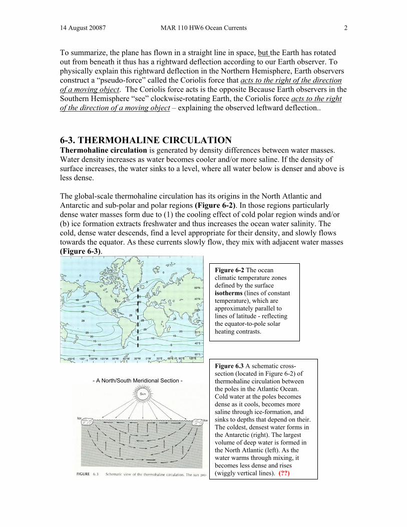
To summarize, the plane has flown in a straight line in space, but the Earth has rotated out from beneath it thus has a rightward deflection according to our Earth observer. To physically explain this rightward deflection in the Northern Hemisphere, Earth observers construct a “pseudo-force” called the Coriolis force that acts to the right of the direction of a moving object. The Coriolis force acts is the opposite Because Earth observers in the Southern Hemisphere “see” clockwise-rotating Earth, the Coriolis force acts to the right of the direction of a moving object – explaining the observed leftward deflection.. 6-3. THERMOHALINE CIRCULATION Thermohaline circulation is generated by density differences between water masses. Water density increases as water becomes cooler and/or more saline. If the density of surface increases, the water sinks to a level, where all water below is denser and above is less dense. The global-scale thermohaline circulation has its origins in the North Atlantic and Antarctic and sub-polar and polar regions (Figure 6-2). In those regions particularly dense water masses form due to (1) the cooling effect of cold polar region winds and/or (b) ice formation extracts freshwater and thus increases the ocean water salinity. The cold, dense water descends, find a level appropriate for their density, and slowly flows towards the equator. As these currents slowly flow, they mix with adjacent water masses (Figure 6-3).
-- A North/South Meridional Section A North/South Meridional Section --
Figure 6-2 The ocean climatic temperature zones defined by the surface isotherms (lines of constant temperature), which are approximately parallel to lines of latitude - reflecting the equator-to-pole solar heating contrasts.
Figure 6.3 A schematic cross-section (located in Figure 6-2) of thermohaline circulation between the poles in the Atlantic Ocean. Cold water at the poles becomes dense as it cools, becomes more saline through ice-formation, and sinks to depths that depend on their. The coldest, densest water forms in the Antarctic (right). The largest volume of deep water is formed in the North Atlantic (left). As the water warms through mixing, it becomes less dense and rises (wiggly vertical lines). (??)
14 August 20087 MAR 110 HW6 Ocean Currents 3
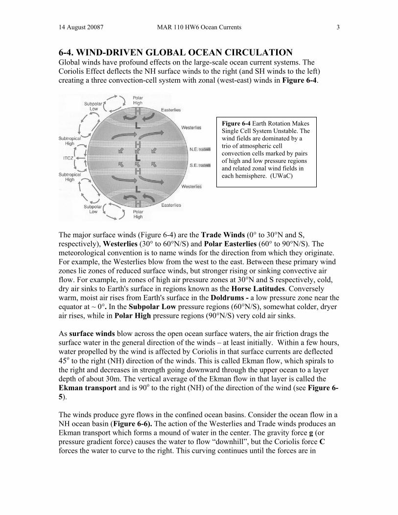
6-4. WIND-DRIVEN GLOBAL OCEAN CIRCULATION Global winds have profound effects on the large-scale ocean current systems. The Coriolis Effect deflects the NH surface winds to the right (and SH winds to the left) creating a three convection-cell system with zonal (west-east) winds in Figure 6-4.
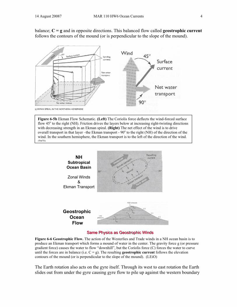
The major surface winds (Figure 6-4) are the Trade Winds (0° to 30°N and S, respectively), Westerlies (30° to 60°N/S) and Polar Easterlies (60° to 90°N/S). The meteorological convention is to name winds for the direction from which they originate. For example, the Westerlies blow from the west to the east. Between these primary wind zones lie zones of reduced surface winds, but stronger rising or sinking convective air flow. For example, in zones of high air pressure zones at 30°N and S respectively, cold, dry air sinks to Earth's surface in regions known as the Horse Latitudes. Conversely warm, moist air rises from Earth's surface in the Doldrums - a low pressure zone near the equator at ~ 0°. In the Subpolar Low pressure regions (60°N/S), somewhat colder, dryer air rises, while in Polar High pressure regions (90°N/S) very cold air sinks. As surface winds blow across the open ocean surface waters, the air friction drags the surface water in the general direction of the winds – at least initially. Within a few hours, water propelled by the wind is affected by Coriolis in that surface currents are deflected 45o to the right (NH) direction of the winds. This is called Ekman flow, which spirals to the right and decreases in strength going downward through the upper ocean to a layer depth of about 30m. The vertical average of the Ekman flow in that layer is called the Ekman transport and is 90o to the right (NH) of the direction of the wind (see Figure 6-5). The winds produce gyre flows in the confined ocean basins. Consider the ocean flow in a NH ocean basin (Figure 6-6). The action of the Westerlies and Trade winds produces an Ekman transport which forms a mound of water in the center. The gravity force g (or pressure gradient force) causes the water to flow “downhill”, but the Coriolis force C forces the water to curve to the right. This curving continues until the forces are in
Figure 6-4 Earth Rotation Makes Single Cell System Unstable. The wind fields are dominated by a trio of atmospheric cell convection cells marked by pairs of high and low pressure regions and related zonal wind fields in each hemisphere. (UWaC)
14 August 20087 MAR 110 HW6 Ocean Currents 4
balance; C = g and in opposite directions. This balanced flow called geostrophic current follows the contours of the mound (or is perpendicular to the slope of the mound).
NHNHSubtropicalSubtropical
Ocean BasinOcean Basin
Zonal Winds Zonal Winds & &
Ekman TransportEkman Transport
GeostrophicGeostrophicOceanOceanFlowFlow
Same Physics as Geostrophic WindsSame Physics as Geostrophic Winds Figure 6-6 Geostrophic Flow. The action of the Westerlies and Trade winds in a NH ocean basin is to produce an Ekman transport which forms a mound of water in the center. The gravity force g (or pressure gradient force) causes the water to flow “downhill”, but the Coriolis force (C) forces the water to curve until the forces are in balance (i.e. C = g). The resulting geostrophic current follows the elevation contours of the mound (or is perpendicular to the slope of the mound). (LEiO) The Earth rotation also acts on the gyre itself. Through its west to east rotation the Earth slides out from under the gyre causing gyre flow to pile up against the western boundary
Figure 6-5b Ekman Flow Schematic. (Left) The Coriolis force deflects the wind-forced surface flow 45o to the right (NH). Friction drives the layers below at increasing right-twisting directions with decreasing strength in an Ekman spiral. (Right) The net effect of the wind is to drive overall transport in that layer –the Ekman transport - 90o to the right (NH) of the direction of the wind. In the southern hemisphere, the Ekman transport is to the left of the direction of the wind. (ItO)
14 August 20087 MAR 110 HW6 Ocean Currents 5
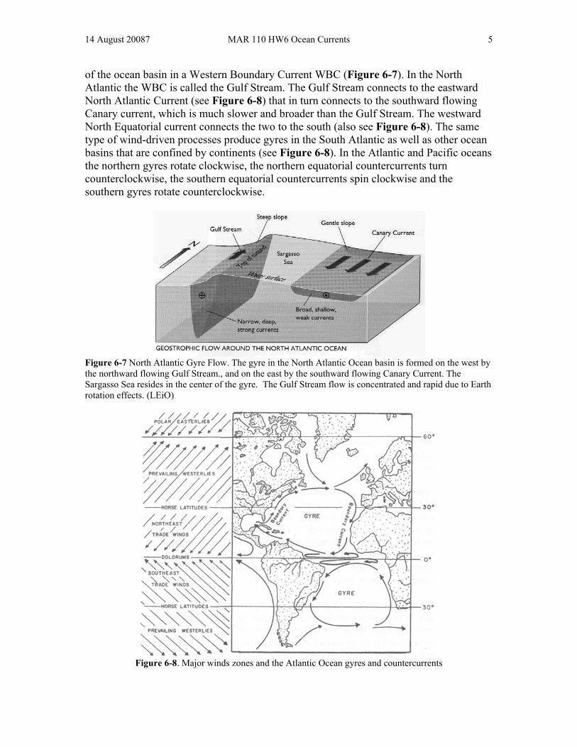
of the ocean basin in a Western Boundary Current WBC (Figure 6-7). In the North Atlantic the WBC is called the Gulf Stream. The Gulf Stream connects to the eastward North Atlantic Current (see Figure 6-8) that in turn connects to the southward flowing Canary current, which is much slower and broader than the Gulf Stream. The westward North Equatorial current connects the two to the south (also see Figure 6-8). The same type of wind-driven processes produce gyres in the South Atlantic as well as other ocean basins that are confined by continents (see Figure 6-8). In the Atlantic and Pacific oceans the northern gyres rotate clockwise, the northern equatorial countercurrents turn counterclockwise, the southern equatorial countercurrents spin clockwise and the southern gyres rotate counterclockwise.
Figure 6-7 North Atlantic Gyre Flow. The gyre in the North Atlantic Ocean basin is formed on the west by the northward flowing Gulf Stream., and on the east by the southward flowing Canary Current. The Sargasso Sea resides in the center of the gyre. The Gulf Stream flow is concentrated and rapid due to Earth rotation effects. (LEiO)
Figure 6-8. Major winds zones and the Atlantic Ocean gyres and countercurrents
14 August 20087 MAR 110 HW6 Ocean Currents 6
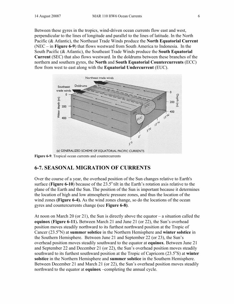
Between these gyres in the tropics, wind-driven ocean currents flow east and west, perpendicular to the lines of longitude and parallel to the lines of latitude. In the North Pacific (& Atlantic), the Northeast Trade Winds produce the North Equatorial Current (NEC – in Figure 6-9) that flows westward from South America to Indonesia. In the South Pacific (& Atlantic), the Southeast Trade Winds produce the South Equatorial Current (SEC) that also flows westward. In the doldrums between these branches of the northern and southern gyres, the North and South Equatorial Countercurrents (ECC) flow from west to east along with the Equatorial Undercurrent (EUC).
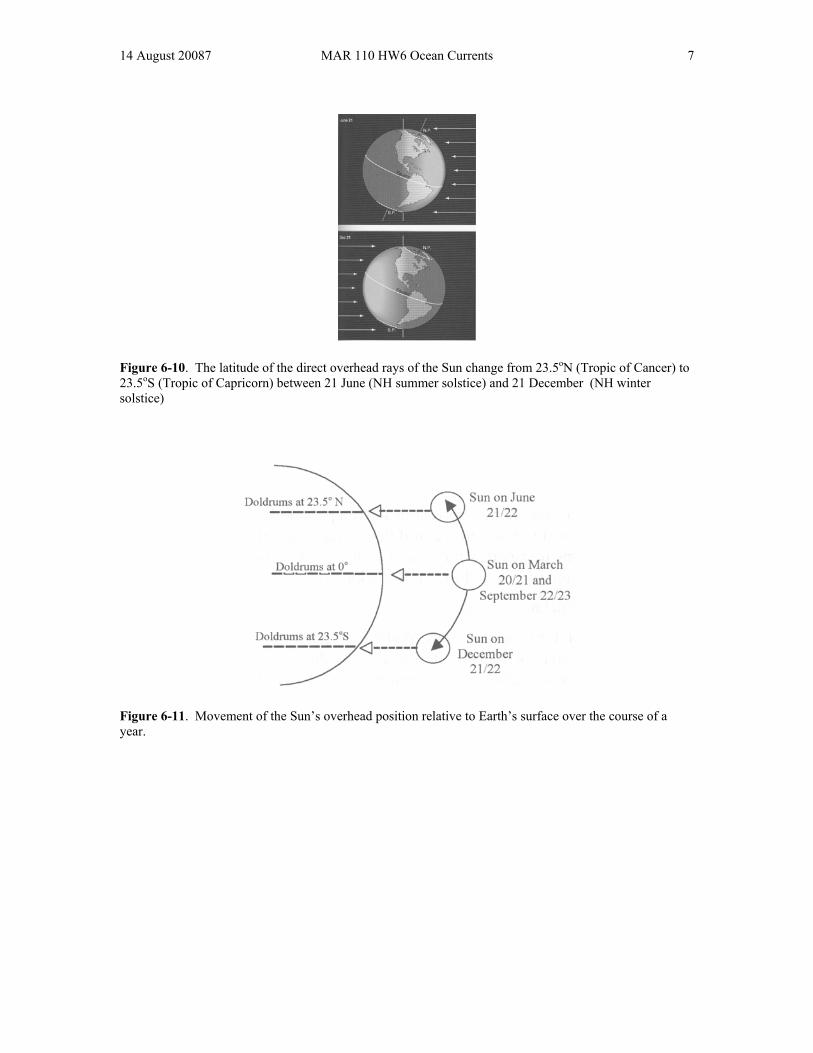
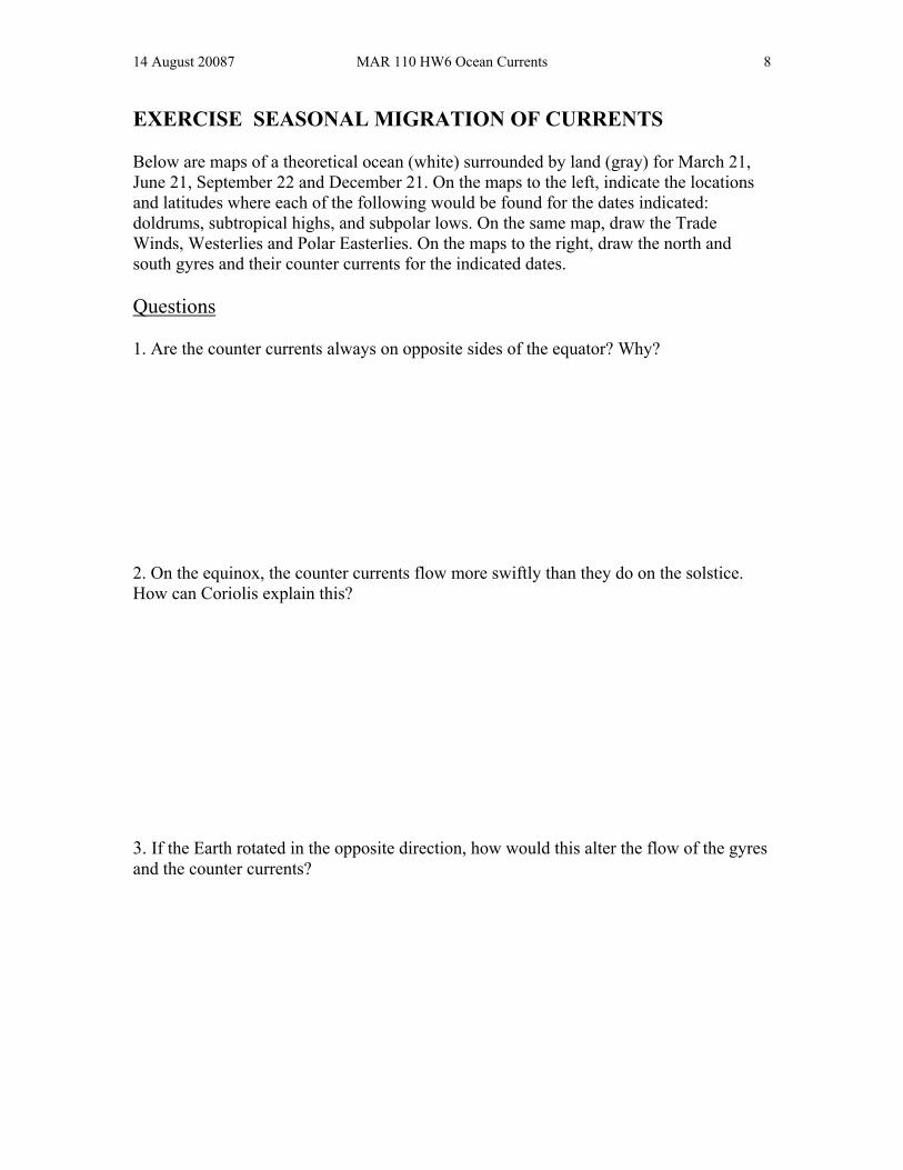
Figure 6-9. Tropical ocean currents and countercurrents 6-7. SEASONAL MIGRATION OF CURRENTS Over the course of a year, the overhead position of the Sun changes relative to Earth's surface (Figure 6-10) because of the 23.5o tilt in the Earth’s rotation axis relative to the plane of the Earth and the Sun. The position of the Sun is important because it determines the location of high and low atmospheric pressure zones, and thus the location of the wind zones (Figure 6-4). As the wind zones change, so do the locations of the ocean gyres and countercurrents change (see Figure 6-8). At noon on March 20 (or 21), the Sun is directly above the equator – a situation called the equinox (Figure 6-11). Between March 21 and June 21 (or 22), the Sun’s overhead position moves steadily northward to its furthest northward position at the Tropic of Cancer (23.5oN) at summer solstice in the Northern Hemisphere and winter solstice in the Southern Hemisphere. Between June 21 and September 22 (or 23), the Sun’s overhead position moves steadily southward to the equator at equinox. Between June 21 and September 22 and December 21 (or 22), the Sun’s overhead position moves steadily southward to its furthest southward position at the Tropic of Capricorn (23.5oS) at winter solstice in the Northern Hemisphere and summer solstice in the Southern Hemisphere. Between December 21 and March 21 (or 22), the Sun’s overhead position moves steadily northward to the equator at equinox –completing the annual cycle.
14 August 20087 MAR 110 HW6 Ocean Currents 7
Figure 6-10. The latitude of the direct overhead rays of the Sun change from 23.5oN (Tropic of Cancer) to 23.5oS (Tropic of Capricorn) between 21 June (NH summer solstice) and 21 December (NH winter solstice)
Figure 6-11. Movement of the Sun’s overhead position relative to Earth’s surface over the course of a year.
14 August 20087 MAR 110 HW6 Ocean Currents 8
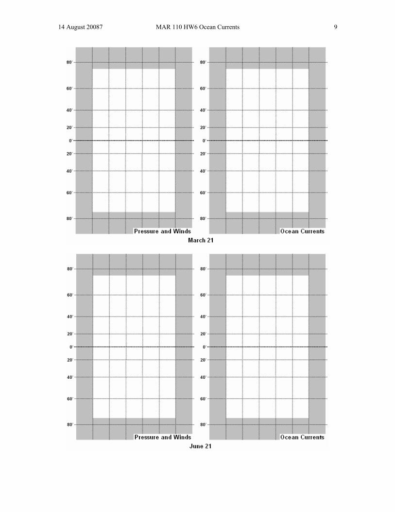
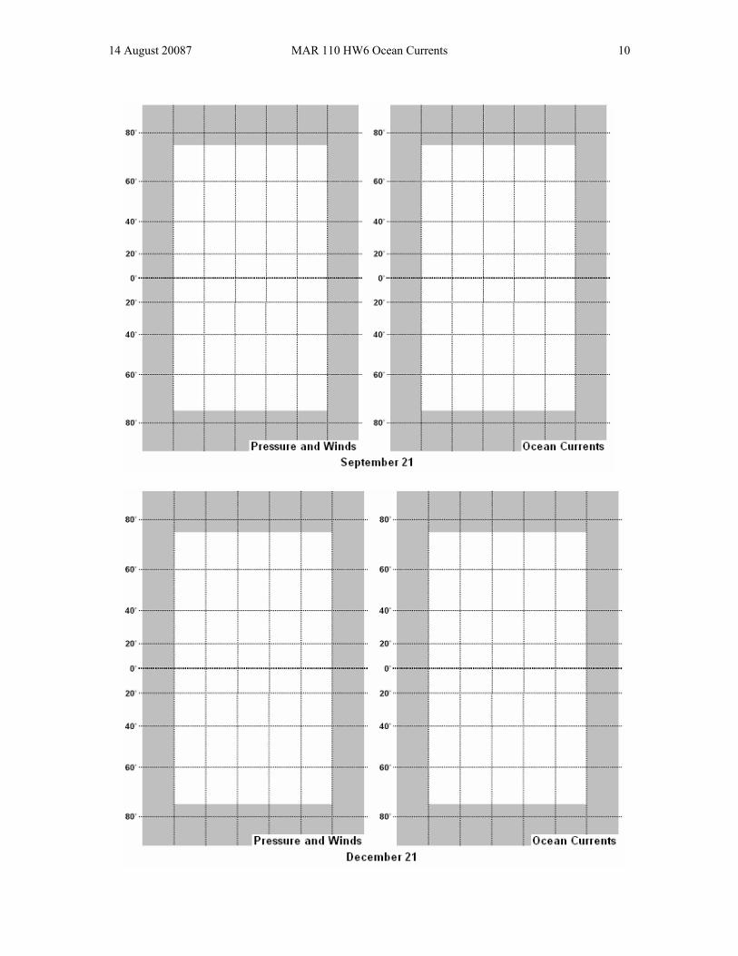
EXERCISE SEASONAL MIGRATION OF CURRENTS Below are maps of a theoretical ocean (white) surrounded by land (gray) for March 21, June 21, September 22 and December 21. On the maps to the left, indicate the locations and latitudes where each of the following would be found for the dates indicated: doldrums, subtropical highs, and subpolar lows. On the same map, draw the Trade Winds, Westerlies and Polar Easterlies. On the maps to the right, draw the north and south gyres and their counter currents for the indicated dates. Questions 1. Are the counter currents always on opposite sides of the equator? Why? 2. On the equinox, the counter currents flow more swiftly than they do on the solstice. How can Coriolis explain this? 3. If the Earth rotated in the opposite direction, how would this alter the flow of the gyres and the counter currents?
14 August 20087 MAR 110 HW6 Ocean Currents 9
14 August 20087 MAR 110 HW6 Ocean Currents 10