Holocene Geologic History and Sedimentology of the...
32
UBP.ARY TUAAL RESOURCES DEPT. Of NA SOURCES DN!GlON GEOLOGY & EARiH RE 7 OLYMPIA. WA. 98604-700 Holocene Geologic History and Sedimentology of the Duwamish and Puyallup Valleys, Washington Stephen P. Palmer Washington Department of Natural Resources Geology and Earth Resources Division September 29, 1997
Transcript of Holocene Geologic History and Sedimentology of the...

UBP.ARY TUAAL RESOURCES
DEPT. Of NA SOURCES DN!GlON GEOLOGY & EARiH RE 7
OLYMPIA. WA. 98604-700
Holocene Geologic History and Sedimentology of the Duwamish and Puyallup Valleys, Washington
Stephen P. Palmer Washington Department of Natural Resources
Geology and Earth Resources Division
September 29, 1997

~er·,~
~"" \1 11 <olt \<.'.'.\"\,
'--c,? ~ '2..- Holocene Geologic History and Sedimentology
0 CT 3 0 1997 of the Duwamish and Puyallup Valleys, Washington
Stephen P. Palmer Washington Department of Natural Resources
Geology and Earth Resources Division
September 29, 1997
Introduction
The following report has been prepared to fulfill the task requirements included in U.S. Geological Survey Requisition No. 96-7440-4455 issued to the Washington Department of Natural Resources. The statement of work for this requisition requires a report that:
• reviews the existing literature and data regarding the geologic history and sedimentology of the Duwamish and Puyallup valleys located in the Puget Sound Lowland, and,
• summarizes the results from drilling two or three shallow borings to acquire samples suitable for radiocarbon dating of the time of transition from a marine to subaerial depositional environment and to perform the dating.
The Duwamish and Puyallup valleys (Figure 1) are presently river valleys but during much of the Holocene were embayments of the Puget Sound. The headwaters of some of the major rivers that have flowed or are now flowing through these valleys (Puyallup and White Rivers) are located on Mount Rainier, and these rivers have carried lahars originating from the mountain to the valley lowlands. The other rivers flowing into the Duwamish valley (Green and Cedar Rivers) originate from drainage basins within the Cascade range that are not directly influenced by volcanic eruptions of Mount Rainier. The nomenclature used in this report for discussing geographical features such as the rivers and valleys is shown in Figure 2b.
The port area of Seattle has been developed on the delta formed at the mouth of the Duwamish River at its interface with the Puget Sound at Elliott Bay. Likewise the Tacoma port area is located on the Puyallup River delta at Commencement Bay. The overall goal of this investigation is to provide a framework for the development of these deltas to assist in the evaluation of seismic hazards of the valley fill and stability of the present-day delta slopes.
Regional Geology ·
The oldest rocks exposed in the study area are lower Tertiary sedimentary rocks termed the Puget Group, subdivided into the Eocene Tukwila and Renton Formations, unnamed marine sedimentary rocks containing Narizian (Eocene) shallow-water marine fossils and interbedded
C
(__,

Holocene Geologic History and Sedimentology Page 2/14 of the Duwamish and Puyallup Valleys, Washington
volcaniclastic rocks, and unnamed sedimentary rocks of Oligocene age correlative with the Blakeley Formation . Tertiary andesite sills and irregularly shaped igneous bcxlies intrude the Tukwila Formation. These bedrock units crop out in the northern part of the Duwamish Valley as isolated knobs projecting from the valley floor.
Pleistocene glacial and nonglacial deposits unconformably overlie Tertiary bedrock in the study area. The youngest of these glacial units was deposited during the Vashon Stade of the Fraser Glaciation (late Pleistocene, ca 13,000 to 15,000 ybp). Vashon till and outwash form a veneer on the broad drift plain that occupies the lowland between the Olympic Mountains and the foothills of the Cascade Range. In the study area this drift plain stands a few hundred feet above valley floors containing the major river systems flowing through the Duwamish and Puyallup valleys.
Water-well data for the area immediately northwest of Auburn show that the midHolocene Osceola Mudflow (Luzier, 1969) is at a depth of approximately 260-280 feet below present-day sea level, indicating that the Duwamish valley was formerly an embayi:nent of Puget Sound. Marine shells reported from numerous shaUow geotechnical borings and water wells in the Duwamish and Puyallup valleys also indicate that these valleys were arms of Puget Sound for some time into the Holocene (Waldron, 1962; Dragovich and others, 1994). Mid- to late Holocene alluvial sand, silt, and gravel have filled the former embayments with significant sediment input from lahars originating from Mount Rainier. Thin, peaty lake deposits also have formed in flood-plain basins in the Duwamish and Puyallup valleys during the late Holocene. Modified or filled land includes extensive fill of Lake Washington at the northern end of the city of Renton and the old course of the White River through the city of Auburn, embankments for railroad lines and roadways, river levees, and foundation pads for major buildings.
Historic Changes to Waterways in the Duwamish and Puyallup Valleys
The port areas of Seattle and Tacoma have been developed on filled tidal marshes during the late 1800's and early 1900's. Fill for the Seattle"port area was primarily derived from hydraulic excavation and regrading of hills in the Seattle city area performed in order to improve transportation and commerce. Morse (1989) provides a comprehensive review of the various Seattle regrading projects. Filling of the tide flats in the Tacoma port area commenced in the late 1880's to support the shipping docks of the Northern Pacific Railroad, and continued with the expansion of the port. There is only sparse documentation of the fill history of the Tacoma port area, and the best source of information on historical modification of the Tacoma tide flats is presented in Hart-Crowser & Associates, Inc. (1974).
A significant area of northern Renton was filled in the early 1900' s as a result of the Lake Washington Ship Can.al project. That project also affected the natural river drainage pattern in the

Holocene Geologic History and Sedimentology Page 3/14 of the Duwamish and Puyallup Valleys, Washington
study area. Before 1900 (Figure 2a), the Black River drained southward from Lake Washington, and the Cedar River was a tributary of the Black River. The Black River had a westward course and flowed into the Green River in the vicinity of the city of Tukwila. After completion of the Ship Canal project, the outlet feeding the Black River was blocked, and the Cedar River was channelized and redirected into Lake Washington (Figure 2b). Flow in the Black River effectively ceased except for the drainage originating on the adjacent drift plain highland. The level of Lake Washington was lowered approximately 9 feet (Chrzastowski, 1983), and in the northern part of Renton both the newly exposed lake bed and surrounding freshwater marshes were filled or otherwise modified by development.
Before 1906, the White River bifurcated as it reached the floor of the Duwamish valley (see Figure 2a), with the White River flowing northward into the Green River and the Stuck River flowing southward as a tributary of the Puyallup River (Willis and Smith, 1899). After a flood in 1906, most of the flow was directed into the Stuck River, and engineering projects permanently diverted the north-flowing White River into the Stuck River, which was renamed the White River (see Figure 2b ). The city of Auburn has developed on the abandoned channel of the former White River.
Channelization of portions of the rivers in the study area has been performed since the major diversions in the early 1900's, primarily to mitigate flooding. Dams have been constructed on the upstream portions of the Cedar, Green, and White Rivers, but the Puyallup River is still a free-running river for the length of its course. The result of the river diversion and dam projects has been to significantly decrease the sediment load reaching the Duwamish delta, and to increase the load reaching the Puyallup delta (at least up to the time of construction of the Mud Mountain Dam on the White River in 1939-41). ·
Late Pleistocene to Mid-Holocene Geology and Sedimentology
The topographic troughs now occupied by the Duwamish and Puyallup valleys are thought to have resulted from scour of sub-glacial meltwater channels during the Vashon Stade of the Fraser Glaciation (Crandell, 1963; Mullineaux, 1970; Booth, 1994). During the glacial maximum during the Vashon Stade sea level was approximately 300-400 ft below its present-day level. During retreat of the Vashon glacier a large freshwater lake system was formed in the Puget Lowland as the Puget lobe acted as an ice dam preventing incursion of marine water. Previous geohydrological studies (Hart-Crowser and Associates, Inc., 1982 and 1985) identified recessional outwash deposits beneath the Puyallup and Duwamish valleys in the vicinity of Puyallup and Auburn. The recessional deposits occur at present elevations of -180 ft MSL or lower, modifying the topography left by the sub-glacial rneltwater channels.
(

Holocene Geologic History and Sedimentology Page 4/14 of the Duwamish and Puyallup Valleys, Washington
The continued retreat of the Puget lobe at the close of the Vashon Stade·(ca 13,000 ybp) allowed marine water to flow into the Puget Lowland. Through the rest of the late Pleistocene and early to mid-Holocene eustatic sea-level rose rapidly. During the early Holocene (up to about 9000 ybp) the Puget Sound lowland was also experiencing the effects of isostatic rebound (Thorson, 1989).
As a consequence relative sea-level within the Puget Sound lowland is poorly understood prior to roughly 6000 ybp. No surface exposures of sediments deposited in the early to midHolocene are available for direct examination, and investigation of Holocene sedimentation in the Duwamish and Puyallup valleys is limited to analysis of geotechnical boring and water well data. Previous studies ( e.g., Luzier, 1969; Dragovich and others, 1994) indicate that much of the infilling of these valleys has occurred since 6000 ybp (mid-Holocene), and that the Osceola Mudflow represented the initiation of significant valley infilling. Thus, the focus of this investigation is on the sedimentological development of these valleys since mid-Holocene.
Effects of the Osceola Mudflow
The Osceola.Mudflow was recognized·by Crandell and Waldron (1956) as a large debris flow originating from Mount Rainier. Based on mineralogy and sediment texture Crandell (1971) recognized that the Osceola Mudflow originated as a large sector collapse of Mount Rainier. The Osceola Mudflow was apparently associated with active volcanism based on the stratigraphic relationship of the mudflow and tephra markers (e.g., Mullineaux, 1974, and unpublished manuscripts of other investigators reported in Dragov:ich and others, 1994). Luzier (1969) and Crandell (1971) recognized thanhe Osceola Mudflow occurred in the subsurface of the Puyallup and Duwarnish valleys, but Dragovich and others (1994) performed the first systematic subsurface mapping of the mudflow. Table 1 summarizes the results of radiocarbon dating of the Osceola Mudflow from a number of past investigations; uncalibrated radiocarbon dates range from 4455 to 5230 C14ybp.
Figure 3a presents a map of the paleogeography of the Puyallup and Duwamish valleys at the time of deposition of the Osceola Mudflow. The positions of the Puyallup and Duwamish deltas are shown on this map near the present towns of Puyallup and Auburn, respectively. Figure 3b shows the present day geography of these valleys. Figure 4 is a map showing the pre-Osceola topography constructed by Dragovich and others (1994) using the base of the Osceola Mudflow interpreted from geotechnical'boring and water well logs. The delta platform appears to be at an elevation of roughly -40 ft (present) MSL, and likely represents the elevation of the tidal marsh and shallow subtidal environment just prior to deposition of the Osceola Mudflow. Dragovich and others (1994) used their subsurface mapping of the Osce0la Mudflow to estimate sediment volumes and average ·sedimentation rates for the Duwamish and Puyallup valleys during the midto late Holocene. A copy of their paper is included in Appendix A.

Holocene Geologic History and Sedimentology Page 5/14 of the Duwamish and Puyallup Valleys, Washington
Other Mid- to Late Holocene Lahars
Investigation of the extent of mid- to late Holocene Mount Rainier lahars in the Duwamish and Puyallup valleys is very limited. At least three post-Osceola lahar events have been identified in the subsurface of these valleys, but their volumes and extent are poorly understood. The three lahar events identified to date are:
• a sandy lahar deposit with a uncalibrated radiocarbon age of approximately 2300 C14ybp that is widely distributed in the Puyallup valley;
• a sandy lahar deposit with a uncalibrated radiocarbon age of approximately 1100 C14ybp that has been recently identified in the Duwamish valley;
• the Electron Mudflow, a cohesive lahar roughly 500-800 year old that reached the upper end of the Puyallup valley in the vicinity of the towns of Orting and Sumner, but has not been identified in the subsurface downstream of its surficial deposits.
A sandy laharic deposit was identified by Palmer and others (1991) and Pringle and Palmer (1992) in the Puyallup valley in the vicinity of the city of Puyallup. This deposit is a massive, medium to coarse sand composed of unweathered crystal fragments and angular to subangular fragments of Mount Rainier Andesite, and contains pumice that is interpreted as being associated with the Mount Rainier "C" tephra. The "C" tephra was produced by eruptions between 2040 and 2340 C14ybp (Mullineaux, 1974), and is correlated with a block and ash deposit identified by Crandell (1971) in the upper Puyallup valley having an uncalibrated radiocarbon age of 2350 ± 250 C14ybp. Twigs recovered from a trench exposing this laharic deposit immediately east of the Puyallup Fairgrounds yielded an uncalibrated radiocarbon· age of 2320 ± 120 C14ybp. Drilling results at this site and at others in the Puyallup area indicate that this laharic deposit is 20-25 ft thick, and represents a significant volume of rapidly deposited sediment.
It is unknown at this time if some of this laharic deposit flowed down the White River and was deposited in the Duwamish valley. Scott and others (1992) indicate that there are a number of occurrences of non-cohesive (sandy) lahars observed in the upstream portions of the White River system that yield calendric dates ranging from 1200-2100 ybp. The largest of these noncohesive lahars is the Deadman Flat lahar assemblage that has an uncalibrated radiocarbon age of 1120 C14ybp. Mount Rainier C-tephra is abundant in this assemblage. These non-cohesive flows are probably the result of volcanism related to the construction of the summit cone, and are thought to have originated as meltwater flood surges (Scott and others, 1992).
Pringle and Vallance (1996) report a sandy laharic deposit discovered in the Auburn area that had buried living Douglas fir trees. Preliminary radiocarbon dating of these killed trees L

Holocene Geologic History and Sedimentology Page 6/14 of the Duwamish and Puyallup Valleys, Washington
indicates that this laharic deposit is approximately 1000 years old. A second buried forest was recently identified in the vicinity of Kent in the Duwamish valley, and yielded a similar radiocarbon age (P. Pringle, 1997, Washington Department of Natural Resources, personal communication). Further downvalley near Kellogg Island a clean black sand mantles an uplifted terrace underlain by inter- or subtidal muds. This terrace is interpreted as having been uplifted as a result of the 1000 ybp earthquake on the Seattle Fault, and a similar black sand deposit is found in the nearby Georgetown district of Seattle (Brian Atwater, 1996, U.S. Geological Survey, personal communication). It is possible that this black sand deposit is related to those observed by Pringle and Vallance (1996) further upvalley based on the similar timing of these event based on sparse radiocarbon dating.
The Electron Mudflow is a cohesive lahar similar in composition to the Osceola Mudflow, although it is much smaller in volume (Crandell, 1971). Radiocarbon dating of the Electron Mudflow suggest that it occurred in the interval from 530-840 C14ybp, and is the youngest of the three post-Osceola laharic deposits presently identified in the Puyallup and Duwamish valleys. The Electron Mudflow is limited to the Puyallup River drainage, and has not been identified in the subsurface downstream of its outcrop area in the vicinity of the towns of Orting and Sumner. This mudflow is not associated with any recognized volcanic activity on Mount Rainier, although is sorting and composition suggests that it originated as a small sector collapse similar to the process responsible for the Osceola Mudflow.
Deposits of at least four laharic assemblages have been recognized as having reached the Duwamish and Puyallup valleys by their identification from surface outcropping or subsurface borings. These four assemblages are the Osceola and Electron Mudflows, and two distinct sandy lahric deposits differentiated by their separate locales and different ages based on sparse radiocarbon dating. Scott and others (1992) note that "at least six lahars can be documented to have inundated parts of the Puget Sound Lowlan~ or can reasonably be inferred to have done so". They also suggest that there are at least seven post-glacial cohesive lahars that might have reached the Lowland. The investigations to date suggest that sedimentation in the Puyallup and Duwamish valleys is dominated by primary lahar deposition and secondary reworking of the laharic material by normal alluvial processes.
Drilling Investigation Performed to Identify Marine/Subaerial Transition
The second task of this investigation was to drill two or three borings in the Duwamish and Puyallup valleys to determine the timing of the transition from marine to subaerial sediment deposition. It is thought that dating this transition will provide a better estimate of the variability of the pro~1adation rates of t.i,e Duwamish and Puyallup deltas. Using both the present locations of these deltas and the position immediately prior to deposition of the Osceola Mudflow Dragovich and others (1994) estimated the average progradation rate for the Duwamish delta as

Holocene Geologic History and Sedimentology Page 7/14 of the Duwamish and Puyallup Valleys, Washington
6.0 km/1000 yrs, and for the Puyallup delta as 2.5 km/1000 yrs. The previous discussion of the potential impact of lahars on sedimentation in these valleys suggests that delta progradation rates over short time intervals may be quite different than these average rates.
Puyallup Valley Drilling Results
An examination of water well records in the Puyallup valley (Walter and Kimmel, 1968) indicated that shell-bearing mud and sand were encountered at depths ranging from 90-120 ft in the middle of the Puyallup valley northeast of Puyallup. This location is approximately 4 to 5 km downvalley of the position of the Puyallup delta at the time of the Osceola Mudflow based on Dragovich and others (1994) mapping, as shown in Figure 4. Figure 5 shows the approximate position of these water wells and the location of boring P-1-97 drilled as part of this investigation. It was thought that obtaining a date on the marine/subaerial transition at this location would provide some insight into the constancy of the average rate of delta progradation suggested by Dragovich and others (1994). Using their average rate the Puyallup delta should have passed the location of boring P-1-97 some 1500-2500 years after deposition of the Osceola Mudflow.
Drilling of boring P-1-97 was performed using a Becker Hammer drill rig. The Becker Hammer uses a modified pile driving hammer to advance a double-walled drill pipe; the exterior drill pipe is 6 7/8" in diameter, and the inner pipe has a 4" diameter. Reverse air circulation is used to blow material from the bottom of the casing up the interior drill pipe to the surface where it is recovered. Drilling can be halted at any depth and undisturbed or disturbed samples may be obtained using A-rods and samplers conveyed though the inner drill pipe. The large volume of returned material (a result of the large diameter casing that is driven) was thought to provide a better chance of recovering woody or shelly material appropriate for subsequent radiocarbon dating. In the soft soils encountered at both drill sites in this investigation the drill pipe was advanced using the rig's hydraulic ram; the pile driving hammer was used only on rare occasion.
The log of boring P-1-97 is shown in Appendix B. A sequence of alluvial (subaerial) sand, silt and gravel was penetrated from ground surface to a depth of approximately 62 ft. A thick silt unit was encountered at a depth of 62 ft grading down to a silty fine sand with interbedded silt at 69 ft depth. At 75 ft depth the silt was observed to be quite peaty, and resembled the mud typically found on present-day tidal marshes in the Puget Sound. At a depth of 93 ft circulated returns contained abundant shell fragments that consist primarily of broken (possibly by drilling) oyster and clam shells. Soil types below 69 ft depth were interbedded silty fine sand and peaty mud, typical of intertidal and shallow sub-tidal sediments. Large volumes of wood fragments that had the appearance of driftwood were returned between depths of 70-80 ft, and from 95-100 ft. Drilling was stopped at a depth of 100 ft.
(/

Holocene Geologic History and Sedimentology Page 8/14 of the Duwamish and Puyallup Valleys, Washington
Wood fragments collected between 75-80 ft depth were prepared and sent to Beta Analytic, Inc. for conventional radiocarbon dating. The uncalibrated radiocarbon date returned from this sample was 5710 ± 70 C14ybp. As the wood fragments used in the dating are clearly older than the surface on which they were deposited this date represents a maximum age for the stratigraphic interval at 75-80 ft depth. The purpose of this composited date was to establish an approximate time of deposition as a guide to future analyses.
The shallowest depth that I interpret the marine/subaerial transition is at the base of the clean fine to medium sand unit at its contact with an underlying thick silt unit. Ground elevation at P-1-97 is approximately +22 ft MSL (from Figure 5), and so I interpret that at this site the marine/subaerial transition occurs at an elevation of roughly -40 ft MSL. Referring to Figure 4, this elevations closely corresponds to the elevation of the delta platform that existed upvalley just prior to the deposition of the Osceola Mudflow.
My preliminary interpretation of the results of drilling P-1-97 is that the marine/subaerial transition encountered in this boring reflects the rapid advance of the Puyallup delta in response to the Osceola Mudflow. Sediments encountered in this boring below a depth of 62 ft are typic_al of those found in the intertidal or shallow sub-tidal zones that occur on the present Puyallup delta platform. The occurrence of oyster shells further indicates a intertidal or shallow sub-tidal setting, although these shell fragments could have been transported to deeper marine water. The date on the wood fragments is older than typically reported for the Osceola Mudflow (see Table 1 ), but because the woody material is clearly reworked the resulting radiocarbon date is going to be older than the age of the surface on which the wood was deposited. The elevation of the interpreted marine/subaerial transition is no higher than -40 ft MSL, and this elevation corresponds closely to the Puyallup delta platform elevation mapped in Figure 4 by Dragovich and others (1994). Based on these arguments I suggest that boring P-1-97 penetrated the location of the Puyallup delta soon after deposition of the Osceola Mudflow. The delta could be expected to prograde downvalley quickly in response to the large volume of sediment delivered by the Osceola Mudflow.
Present day relative sea level in the Puyallup valley is reported to be rising approximately 3 mm/yr (Shipman, 1990). If this rate has remained relatively constant in the. last 5000 yr then the delta platform should shallow by roughly 10 ft every 1000 yrs (ignoring any compaction or tectonic overprinting). The shallowest that I interpret the marine/subaerial transition in boring P-1-97 is at -40 ft MSL, roughly the same elevation of the Puyallup delta just before the Osceola Mudflow. The similarity of these delta platform elevations and the rapid relative sea level rise in this vicinity further supports my contention that the Puyallup delta prograded to the location of P-1-97 very quickly as no shallowing due to rapid relative sea level rise is apparent in my interpreted elevation of the marine/subaerial transition.
Holocene Geologic History and Sedimentology Page 9/14 of the Duwamish and Puyallup Valleys, Washington
Duwamish Valley Drilling Results
Geotechnical borings drilled by the Washington Department of Transportation for the Southcenter Boulevard-State Route 405 interchange construction were used to site boring K-1-97 drilled as part of this investigation (Hart-Crowser and Associates, Inc., 1993). These boring logs indicated that a shell-bearing silty sand unit was encountered beneath a sequence of alluvial sand and silt. Figure 6 shows the approximate position of boring K-1-97 in the Tukwila area. The drilling site was chosen because of the boring control provided from the interchange project, as well as its location where the Duwamish valley narrows through a bedrock-controlled gap. South of this gap the Duwamish valley is 5-6 km wide, whereas north of this gap the valley narrows to a width of approximately 2 km. The drill site is approximately 20 km north of the location of the Duwamish delta just prior to deposition of the Osceola Mudflow.
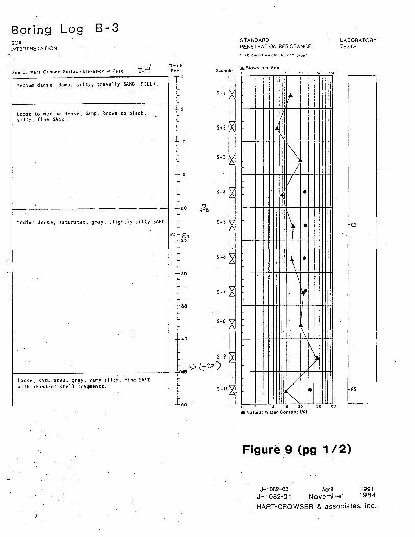
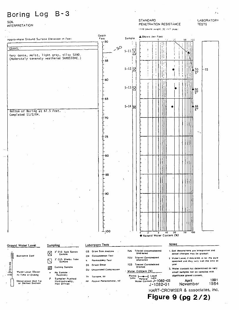
Figure 7 is a site map showing the locations of borings and cross-sections used in the interchange construction project and the location of boring K-1-97 (Hart-Crowser and Associates, Inc., 1993). Figure 8 is cross-section A-A' from Hart-Crowser and Associates, Inc. (1993) showing a steeply dipping bedrock surface overlain by Holocene marine and fluvial deposits. The occurrence of shell fragments in borings B-3 and B-6 is annotated on this crosssection. Figure 9 is the log of boring B-3 showing a sequence of clean to silty alluvial sands overlying a shell-bearing silty sand that in turn overlies weathered bedrock.
The log of boring K-1-97 is shown in Appendix B. This boring penetrated a sequence of silt with. some interbedded sand beds between the surface and a depth of 32 ft. From a depth of 32 ft to 61 ft a homogenous unit of black clean fine to medium sand was encountered. A black silty fine sand containing shell and wood fragments was encountered.in the depth interval from 61 ft to 70 ft. These shell fragments consisted of broken mussel and clam shells, and whole shells of a small (0.5 cm length) gastropod (periwinkle?). The contact at 61 ft depth between the clean sand and underlying shell-bearing silty sand is interpreted as the marine/subaerial transition; this transition is at an elevation of approximately -30 ft MSL.
Wood fragments collected between 61-70 ft depth were prepared and sent to Beta Analytic, Inc. for conventional radiocarbon dating. The uncalibrated radiocarbon date returned from this sample was 2670 ± 70 C14ybp. As the wood fragments used in the dating are clearly older than the surface on which they were deposited this date represents a maximum age for the stratigraphic interval at 61-70 ft depth. The purpose of this composited date was to establish an approximate time of deposition as a guide to future analyses.
Recommendations for Further Analysis of Drilling Results
The radiocarbon dates obtained on the reworked wood fragments obtained in borings P-1-97 and K-1-97 are definitely older than the stratigraphic surface on which they were deposited. (_/

..... __ .
Holocene Geologic History and Sedimentology Page 10/14 of the Duwamish and Puyallup Valleys, Washington
Other woody material collected from these borings included intact Douglas fir cones and thin twigs with attached buds. AMS dating of these materials would provide a good estimate of the age of the surface on which they were deposited, an would resolve the uncertainty of the composited dates. Also important will be to accwately determine the elevation of these drill holes from local benchmarks so that the elevation of the marine/subaerial transition can be better determined .
Holocene Geologic History and Sedimentology Page 11/14 of the Duwamish and Puyallup Valleys, Washington
References
Booth, D. B., 1994, Glaciofluvial infilling and scour of the Puget Lowland, Washington, during ice-sheet glaciation: Geology, v. 22, no. 8, p. 695-698.
Chrzastowski, M. J., 1983, Historical changes to Lake Washington and route of the Lake Washington Ship Canal, King County, Washington: U.S. Geological Survey Water-Resources Investigations Report 81-1182, 9 p., 1 sheet.
Crandell, D.R., 1963, Surficial geology and geomorphology of the Lake Tapps quadrangle, Washington: U.S. Geological Survey Professional Paper 388-A, 84 p., 2 pl.
Crandell, D.R.; Waldron, H. H., 1956, A recent volcanic mudflow of exceptional dimensions from Mt. Rainier, Washington: American Journal of Science, v. 254, no. 6, p. 349-362.
Crandell, D. W., 1971, Postglacial lahars from Mount Rainier, Washington: U.S. Geological Survey Professional Paper 677, 75 p., 3 pl.
Dragovich, J. D.; Pringle, P. T.; Walsh, T. W., 1994, Extent and geometry of the mid-Holocene Osceola Mudflow in the Puget Lowland -- Implications for Holocene sedimentation and paleogeography: Washington Geology, v. 22, no. 3, p. 3-26.
Hart-Crowser and Associates, Inc., 197 4, Geology of the Port of Tacoma: Hart-Crowser and Associates, Inc., 40 p.
Hart-Crowser and Associates, Inc., 1982, Ground water study, Auburn, Washington: HartCrowser and Associates, Inc., J-1079, 19 p.
Hart-Crowser and Associates, Inc., 1985, Ground water study, Puyallup, Washington: HartCrowser and Associates, Inc., J-1462-01, lv.
Hart-Crowser and Associates, Inc., 1993, Geotechnical engineering design study, SR 405/ SR 181/Green River Interchange Modifications, Tukwila, Washington: Hart-Crowser and Associates, Inc., prepared for the Washington State Department of Transportation, J-1082-03, lv.
Luzier, J.E., 1969, Geology and ground-water resources of southwestern King County, Washington: Washington Department of_Water Resources Water-Supply Bulletin 28, 260 p., 3 pl. .
(' "- '
Morse, R. W., 1989, Regrading years in Seattle: In Engineering Geology in Washington, R. W. (_,
Holocene Geologic History and Sedimentology Page 12/14 of the Duwamish and Puyallup Valleys, Washington
Galster, editor, Washington Division of Geology and Earth Resources Bulletin 78, v. 2, p. 691-702.
Mullineaux, D. R., 1970, Geology of the Renton, Auburn, and Black Diamond quadrangles, King County, Washington: U.S. Geological Survey Professional Paper 672, 92 p.
Mullineaux, D.R., 1974, Pumice and other pyroclastic deposits in Mount Rainier National Park, Washington: U.S. Geological Survey Bulletin 1326, 83 p.
Palmer, S. P.; Pringle, P. T.; Shulene, J. A., 1991, Analysis ofliquefiable soils in Puyallup, Washington. In Earthquake Engineering Research Institute, Proceedings of the Fourth International Conference on Seismic Zonation -- August 25-29, 1991, Stanford, California, USA: Earthquake Engineering Research Institute, v. II, p. 621-628.
Pringle, P. T.; Palmer, S. P., 1992, Liquefiable volcanic sands in Puyallup, Washington, correlate with Holocene pyroclastic flow and lahar deposits in upper reaches of the Puyallup River valley [abstract]: Geological Society of America Abstracts with Programs, v. 24, no. 5, p. 76.
Pringle, P. T.; Vallance, J. W., 1996, Pumiceous deposit in Auburn, Washington -- Evidence of laharic inundtion in the Puget Lowland triggered by a relatively small eruptive event at Mount Rainier [abstract]: Geological Society of America Abstracts with Programs, v. 28, no. 5, p. 102-103.
Scott, K. M.; Pringle, P. T., Valance, J. W., 1992, Sedimentology, behavior, and hazards of debris flows at Mount Rainier, Washington: U.S. Geological Survey Open-File Report 90-385, 106 p., 1 pl.
Shipman, H., 1990, Vertical land movement in coastal Washington: Washington Geologic Newsletter, v. 18, no. 1, p. 26-33.
Thorson, R. M., 1989, Glacio-isostatic response of the Puget Sound area, Washington: Geological Society of America Bulletin, v. 101, no. 9, p. 1163-1174.
Walters, K. L.; Kimmel, G. E., 1968, Ground-water occurrence and stratigraphy of unconsolidated deposits, central Pierce County, Washington: Washington Department of Water Resources Water-Supply Bulletin 22, 428 p., 3 pl.
Waldron, H. H., 1962, Geology of the Des Moines quadrangle, Washington: U.S. Geological Survey Geologic Quadrangle Map GQ-159, 1 sheet.
Willis, Baily; Smith, G. 0., 1899, Geologic atlas of the United States--Tacoma folio, Washington: U.S. Geological Survey Geologic Folio 54, 10 p.

Holocene Geologic History and Sedimentology Page 13/14 of the Duwarnish and Puyallup Valleys, Washington
Tables
Table 1
Figures
Figure 1
Figure 2
Figure 3
Figure 4
Figure 5
Figure 6
Figure 7
. List of radiocarbon dates related to the Osceola Mudflow from a number of past investigations of this deposit. Taken from Dragovich and others (1994).
Location map showing the study area of this investigation.
a) Historic courses and names of rivers prior to rechannelization of the White/Stuck Rivers and construction of the Lake Washington Ship Canal Project. b) Existing courses and names of rivers in the study area. Figure modified from Luzier (1969).
a) Paleogeography of the Duwamish and Puyallup valleys at the time of deposition of the Osceola Mudflow. Fine stippling indicates the surface outcrop of the mudflow, and coarse stippling shows the deposition of the Osceola Mudflow in the river valleys upstream from the ancient Puyallup and Duwarnish deltas that are now covered by more recent alluvium. b) Modern geography of the Duwamish and Puyallup valleys. Figure taken from Dragovich and others (1994).
Map showing the pre-Osceola topography constructed using the base of the Osceola Mudflow interpreted from geotechnical boring and water well logs. Location of boring P-1-97 shown as a filled circle. Figure taken from Dragovich and others (1994).
Location of three water wells (filled circles) documented in Walters and Kimmel (1968) in which shell-bearing mud or sand were encountered at depths of 90-120 ft, and the location of boring P-1-97 (star) drilled as part of this investigation. Base map is the Puyallup 7 .5' topographic quadrangle (scale 1 :24,000).
Location of boring K-1-97 drilled as part of this investigation (star symbol). Base map is a compilation of the Renton and Burien 7.5' x 15' topographic quadrangles (scale 1:25,000, metric).
Site map showing the locations of borings and cross-sections used in the interchange construction project and the location of boring K-1-97 (star). Figure taken from Hart-Crowser and Associates, Inc. (1993).
Holocene Geologic History and Sedimentology Page 14/14 of the Duwamish and Puyallup Valleys, Washington
Figure 8
Figure 9
Cross-section A-A' from Hart-Crowser and Associates, Inc. (1993) showing a steeply dipping bedrock surface overlain by Holocene marine and fluvial deposits. The occurrence of shell fragments in borings B-3 and B-6 is annotated on this cross-section.
Log of boring B-3 showing a sequence of clean to silty alluvial sands overlying a shell-bearing silty sand that in turn overlies weathered bedrock. Figure taken from Hart-Crowser and Associates, Inc. (1993).

Laboratory Uncalibrated
Calibrated age Calibrated age 14c age Source of sample number
(years B.P.) (years B.P.) (years B.C.)
Univ. of Wash. 5040 ± 150
5931 (5850, 5830, 3981 (3900, 3880, Wood from well hole 22/4-35H2; Osceola UW-62 5750)5612 3800)3662 Mudflow at 265-280 ft bps!; Luzier (1969)
U.S. Geo!. Surv. 4700 ± 250
5659 (5452, 5365, 3709 (3503, 3416, Wood from Osceola Mudflow W-564 5332)4997 3383)3047 (Crandell, 1971)
Lamont Geol. 4800 ± 300
5896 (5580, 5503, 3946 (3631, 3554, Wood from Osceola Mudflow Observ. L-223A 5497)5057 3548)3107 (Crandell, 1971)
Lamont Geol. 4950 ± 300 5988(5658)5322 4038(3709)3372 Wood from Osceola Mudflow
Observ. L-223B (Crandell, 1971)
U.S. Geol. 5020 ± 300 6170 (5741) 5337 4220 (3792) 3387 Peat from above tephra layer N and below Survey W-2053 layer F at Mount Rainier (Crandell, 1971)
Geochron Lab. 1 4455 ± 355 5584 (5042, 5001, 3634 (3093, 3052, Wood from Osceola Mudflow 4998)4564 3049) 2614 (Scott and others, 1992)
Geochron Lab. 2 4980 ± 200 5927(5721)5489 3977 (3772) 3539 Wood from Osceola Mudflow (Scott and others, 1992)
6285 (5982, 5974, 4335 (4033, 4025, Charcoal fragments from base of lahar
Geochron Lab. 3 5230 ± 235 under Osceola Mudflow 5947)5730 3998)3780 (Scott and others, 1992)
Beta Analytic 5010 ± 80 5892(5736)5652 3942(3787)3702 Twigs from WA DOT borehole B-3,
65937 4 km north of Sumner
~ O"
Beta Analytic 4700 ± 60
5569 (5450, 5370, 3619 (3500, 3420, Wood from Osceola Mudflow at 66269 5330)5320 3380)3370 Puyallup River Bridge at Sumner -(1)
..I,
Beta Analytic 10,160 ± 200 12,258 (11, 870) 10,308 (9920) 9094 Wood from 235 ft depth at
72328 11,044 Puyallup Recreation Center well

.. · .·. . ··.·~ ·._··._v
·.·~·.·
.<b ~. ~·
n.· . . '-...l...
Vashon Island
Seattle
•
Puyallup
Lake I Washington
I (@ Lake
Sammamish
49° I
I I. I I I I I I I I I I
I I ___________ _J.:_
Cedar • Kent
I I I I I I
- 47° 30'
Figure 1

!Yashington
47° 30'
.River
i ...__
4 7° 1 5'
... ~
0 2
A 0 2 4 6km B
i
.Lake !Yeshington
4 7° 30'
.River
Lake level lowered and . Cedar and Black Rivers
diverted in 191 7
Diverted in 1906
""-
1 1 2· 15'
47° 151
~ ..... -e. ~
'"'
Figure 2

47°30'
47°15'
,, -· cc C ., (I)
c,_,
[I] . . Land surf ace in valley bottoms
--0 C. \.0 ~ (J)
~ ti.
(.1;)
%-~ ?,
(.1;)
~
marine embayment
() 5 I--~-,---~ () 10 km
ITITifl Osceola Mudfl.ow d~posit EillfilfJ exposed on dnf I plain
122°00'
·, •:::
an~~:;~;al ;~ii~ River
~ Delta
47°30'
well cuts the Osceola Mudf low 215 ft (66 m) below sea level
L-
~ ~
valley study c1rec1
A. about 5,700 yr ago
' Path of the Osceola Mudflow
122°00'
N~ Lake Washington
U. Present

47° 20'
47° 10'
Puget
Sound
Duwamish embayment
122° 20'
EXPLANATION
Topographic contour (20-ft [6 m] contour interval)
Datum is present sea-level
122° oo'
Figure 4

'! 11 ,- I-
z "' . .. " CX) l<J
. ,-
Figure 5

Figure 6

Site and Exploration Plan
~.
···:..
,, -· ca C ... CD .......
Soulhcenler Boulevard Green River Overcrossing
.. ,_:.;...:.~·~ ..
AL/BL Ramp Green River Overcrossing
AL/BL Embankment
AL/BL Ramp Soulhcontor BotJlovard Ovcrcrossing
b'----'1----Green River Channel-1963
,,•'
~ HC-1
Efl B-1
l'w TP-1
e P-1
. C-1
~ Aj
Boring Location and Number (Shallow Borings)
Boring Location and Number (Deep Borings)
Tesl Pit Location and Number
Cone Penetromeler Location and Numbilr
Concrelo Core Location and Number
Prolile Location and Designation
0 200
~Scale in Feel
... ...
400
HIJRTCROWSER J-1082-03 7 /91

Generalized Subsurface Profile A-A'
A 60
40
20
.; Ql u. .s 0 C: .2 ~ Q)
w
-20
-40
-60
-80 Sia. 26+00
'Tl -· cc C .. CD (X)
B-1 Cl 1/8/84) B-2
~
1-......_,_
SIIQhtly Wea1hered BASA1J
28+00 B-6
r
'\ ~ \ 'v'
Soulhcenler Boulevard . Greon River Overcrossing (Figure 3)
'.Ji:::,. -
ATD f'-._-._ ---- ---Modlum D8nse,
SIIQh1ly Silty SANO
.....
Wealhered SANDSTONE
~--"" \ ~~
B-6 (11/7/84)
MOOlum Dense. Sli!Jhtty
Silty SANO
Donse SANO
Medium Slill SILT
Medum Dense SANO (FILL)
Med<Mn Ot<lM SANO
with Scattered Gravel & Cobbl ..
(FILL)
Denae, Slightly SWty SANO -
Medium SIIII, Sandy Slt.T
.............................. 1 Medium Dense, S11Qhl1y, Silty
SANO
.NEL
30+00 Boring Number
Boring Loca lion
Water Level al Time of Drilling
Woalhefe!I SANDSTONE
32+00 34+00 36+{)()
Interval where shell fragments noted on boring logs
38+00
Horizonlal Scafe in Feet i 200 0 100
·o 20 ,.·i40 -...
A'
40+00
Vertical Scale in Feel Vertical Exaggera lion x 5 11.!MrrCROWSER
J-1082-03 2/93
89ri"ng Log SOIL INTERPRETATION
8-3
Aoora:i,mara Ground Suclace Elevation 1n Feel
Hedium dense, damo, silty, 1ravelly SANO (FILL).
Loose to medium dense, damp, brown to black, s i 1 ty, fine SA!ID.
-------- --------~edium dense, saturated, gray, slightly silty SAND.
Loose, saturated, gray, very silty, fine SAHD with abundant shell fragments.
>
Deo1n Feel
0
'5
10
15
20
o E\ 25
30
35
40
.5L ATO
Samo1e • I
S-1 ~ I
S-3
S-4
S-5
S-6
S-7
S-8
S-9
~5 (:2..0')
50
STANDARD PENETRATION RESISTANCE
.A. Slows oe, Fool •:J - 50 "GC
' I
~ ! ! . I : I::. ' I i i ,· .. , I i; !
i I I ! jr; 11!
11'\t I i
1111 f I i I i I , I 1 I
I Ii 1 i I I 11 I
I If I i I
i I I
I I
I\ I
• I
V •
~ .. •
... • \ \ ~
• \
I\ ~
l/ V
/ • ~
l 2 5 10 20 50 100
• Na1ural Waler Con1en1 (%)
LABORATORY TESTS
GS
GS
Figure 9 (pg 1 /2)
J-1082-03 April 1991 J-1082-01 November 1984
HAAT-CROWSER & associates, inc.
Boring Log 8-3 SOIL INTERPRETATION
AootoJ•mata Ground Su,~ace Eleva11on ,n Feet
GrtAVl:L ·
Very dense, .noist, light gray, silty SA~D . (:ioderately severely ~eathered SANDSTONE.)
Bottor., of Boring at Completed 11/2/84.
Ground Water Level
Ben101"t• Seal
Waler Ltv•I CO.alt)
Al Tun, of Ordhno
Ot,serv.ahon Well Tio or Slolled Sec11on
67.5 feet.
Sampling
p
2· c:'.O. Solit Sooon Samele
J'" p.O. S1'1elby Tu1::ie s~m;>fe
Cu11tn9 Samol•
No s~mol• . Recove,y
Samoler Pushed Hydraulically. Not Oriv..n
Deolh Feel
50
60
65
70
75
80
85
90
_ioo
Laboratory Tests
GS GtaM'I s,ze AnaJys1s
CN Con1ol.ld.atton Ttsr
>< Pe,meaoi'-ty Test
OU Unconfined Comcress1on
TV Torvane. 1st
PP Pock.el Pene1rome1e,. Isl
STANDARD PENETRATION RESISTANCE
LABORATORY TESTS
Sample .t.. Blows oer ,001
i : I. :
;
' i
1·'
• 1:
; :: i :-; •: ! ' l j I
i I
;o
'. ! ! I' N i ! I I("' so ' : I ii: 5" 1,,
GS • \
11 i :Iii 1·11 · hi 1--_._~l-++-;+!-+1 -...--......... +++-1-+l
-
I· • 11o6a 6"
I . 2 S 10 20 so 100
• Natural Water Content (%]
TUU Tria:a:iat Unconsohda1ed UndraN"I~
TCV Tri.axial Consokdared Undratned
TCO Tn.1:ual Consoltdattd Drained
Water Content (")
Pl .. hC r----f L,ou,d .
Notes
t. Soil descrlohons .ue in1erpret1v• and actual ch1no•• may c,e gradual.
Water l•••I. 11 ind1ca1ed. as 10, lhe dat•
u,ec1fMd ~nd m1y vary w,1n 1ne ltm• ot
ytlf
J. Water contanr not delarmined on vary small samples nor on samoles with
sioniflcanr gravel con1ent. l1mu Natural ltmll
Waler Contonl J-1082-03 April November
1991 1984 J-1082-01
HART-CROWSER & associates, inc.
Figure 9 (pg 212)
Appendix A
Reprint of Dragovich and others, 1994

Appendix B
Logs of borings P-1-97 and K-1-97

BORING: P-1-97 DRILL METHOD: Becker Hammer Pg_1 _of_2 _ -----------------
DATE: Sept. 9, 1997
LOCATION: WSU Experimental Station Farm #3; 70th Ave, Fife WA
NOTES: -----------------------------------------------
DEPTH (ft)
0-
5-
V 10 -
15 -
20 -
25 -
30-
35 -
40 -
45-
·50 -
BLOWS/6"
7,11,11 (22)
11.13.11 (24)
5,8,9 (17)
2,3,2 (5)
4,5,2 (7)
0.0.1 (1)
6,10,15 (25)
4,2,2 (4)
SAMPLE DESCRIPTION
Light tan to gray clean fine to medium sand with silty sand lenses. Mottled brown with occasional oxidized horizons.
Silty fine sand with blue-gray silt beds.
Brown non-plastic silt with scattered small wood fragments.
Black clean fine to medium sand with silt lenses.
Gray plastic silty clay with abundant organics.
Black clean fine to medium sands. Small rounded gravels at 36'. At 40' sands became heaving.

BORING: P-1-97 DRILL METHOD: Becker Hammer ----------------- Pg_2_of_2_
DATE: Sept. 9, 1997
LOCATION: WSU Experimental Station Farm #3; 70th Ave, Fife WA
NOTES:
DEPTH (ft)
50 -
55 -
60 -
65 -
70 -
75 -
80 -
85 -
90 -
95 -
100 II . - . - . - . - . - . - . - . -
BLOWS/6" SAMPLE DESCRIPTION
Black clean fine to medium sands; heaving.
Gray non-plastic silt, slightly sandy.
Gray silty fine sand with thin silt layers. Wood fragments at 70-75'
Gray silty fine sand and thin peaty silt layers. Wood fragments at 75-80'.
Silty fine sand with silt layers grading down to clean sand.
Black clean fine to medium sand.
Brown peaty silt with shell fragments at 93'.
Silty fine sand with abundant wood fragments .
TD @ 100'

I
BORING: K-1-97 DRILL METHOD: Becker Hammer Pg_1 _of_2 _
DATE: Sept. 22, 1997
LOCATION: 6701 Fort Dent Way. Tukwila, WA.
NOTES: ------------------------------------------------
DEPTH (ft)
0-
5-
-•O•-•O•-•O•
6! _;_ io~ .;_ i6~.:: .:.;(j:.:.~c'.):.:.:(j; : . : ...... ·;..:. O•-•O•-•O•-• : .. :: .... ::..:. -•0•-•0•-•0•
6:.:.~a:.:.~a:.:; :: ::: :: :: ::-:
I--·····-·····-···-
:=: .... - ..... - .. ·.:: -·····-· .. ··-····f-·····-·-···-··· ·-
t:::::=:::::=::·.:~ -····--.... - ..... _ 1--~:.:..:.:.:.-;:-::.:.:.:.: .... -
10 - ~ .. :=.=-=····-
15 -
20 -
25-
'Q 30
35
---· -· ............... -·····-·····-···-_:-:-:-:-::.:.:..·;;;;:::.:.:.: .... _ i---::-:-::.:..:..·.-:-:-:.::.:.:.: .... _
:::::::=:::::=:::::: ···-·····-···-·-·· -····-··· .. -·······-·····-·····-·· ,.... ..... ___________ _ ···-·····-···-·-·· -·-··-·····-·····~---··-·····-·····--=·:::.:.:.-::-:::.:.:.: .... _
-·····-·····-·····= -·····-·····-·····-
=..: .. - ..... -.:··•= .:...., .. ·-·····-·····-
- 2¢2 ~ ____ ::.::..·.~::.:.;: __ , __ ···.77::.::..·.7::'::.:.;: .... _
_ ::::-=:::::-=::·:= - ... :~.7::'::.:.;:;-:-:-:-:· ···.-:-:-::.::.:.:..·.-:::::::: . ..:.:. ···-
- ::::2:t.:2:::·: ···.-:-:-:-·.:..:..: .. :.-:::-.·:.:.:.: .... --::::E.~:§::::: -:.:-:-:-:-:-:-:.:-:-·-:-:-:-:
.·.·.·.·.·.·.·.·.·.· .. ·.·. 40 - ·.·.:-:::::::::::-:-:::::: ...
45 -
50 -
.·.·.·.·.··.·.·.·.·.·.·.·.·.· .....
.. ········. •.......... ,
. ;: · .. .
BLOWS/6"
10,7,5
(12)
19,34 34/6'
5,2,1 (3)
2,2,1 (3)
0,0,6 (6)
2,2,9
(11)
3,7,17 (24)
3,8,15 (23)
SAMPLE DESCRIPTION
Silty, gravelly sand fill.
Brown to gray silt with sand
Gray silty, gravelly sand
Gray non-plastic silt with lenses of very silty fine sand.
Silt becomes more plastic.
Black clean fine to medium sand Scattered rounded gravel @ 37'
Wodd fragments at 40'-45' Heaving at 42'

BORING: ~K~-~1--9~7 __________ _ DRILL METHOD: Becker Hammer Pg_2 _of_2 _
DATE: sept 22 1997
LOCATION: Fort dent Way, Tukwila WA.
NOTES: -------------------------------~-------
DEPTH (ft)
50 -
55 -
60
65
.... ···--·
70 - ····-··
75 -
80 -
85 -
90 -
95
100 -
BLOWS/6"
4,9,17 (26)
SAMPLE DESCRIPTION
Wood fragments at 50'-60'
Black silty sand
Shell and wood framents from 61 '-70'
TD @ 70'