Holistic Pacing World Geography 2017-2018 to Compacted World Geography ! ... economic globalization...
41
Holistic Pacing Map Jackson Public Schools Introduction to Compacted World Geography First Nine Weeks Second Nine Weeks 2017-2018 School Year *denotes objectives from 6 th grade World Geography Grade: 8th Unit: Physical and Human Geography Unit: Western Europe • 1a. • 2a. • 2b. • 3a. • 3b. • 3c. • 4a. • 5a. • 5b. • 6a. *4a, 5a,5c, 7b. 8a, 8b No. of Days 12 • 1a. • 1b. • 2a. • 2b. • 3c. • 4a. • 5a. • 5b. • 5d. • 6c. *7b.,8a,8b No of Days: 20
Transcript of Holistic Pacing World Geography 2017-2018 to Compacted World Geography ! ... economic globalization...
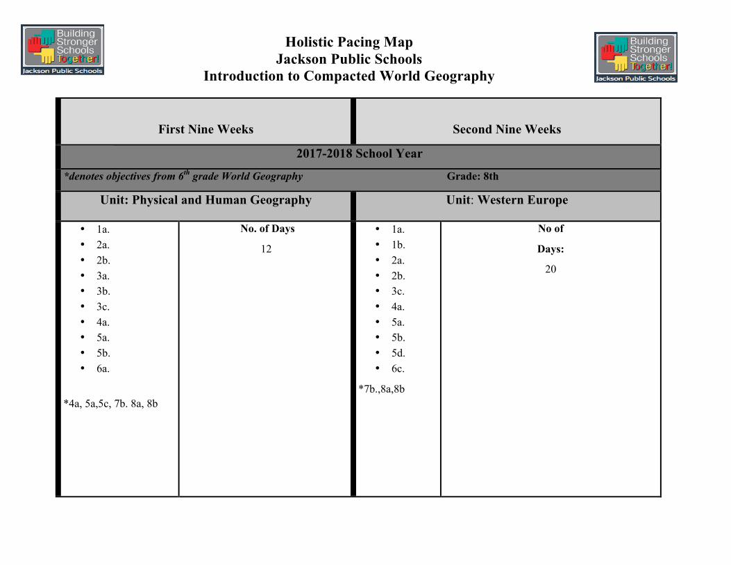
Holistic Pacing Map Jackson Public Schools
Introduction to Compacted World Geography
First Nine Weeks
Second Nine Weeks
2017-2018 School Year
*denotes objectives from 6th grade World Geography Grade: 8th
Unit: Physical and Human Geography Unit: Western Europe
• 1a. • 2a. • 2b. • 3a. • 3b. • 3c. • 4a. • 5a. • 5b. • 6a.
*4a, 5a,5c, 7b. 8a, 8b
No. of Days
12
• 1a. • 1b. • 2a. • 2b. • 3c. • 4a. • 5a. • 5b. • 5d. • 6c.
*7b.,8a,8b
No of
Days:
20
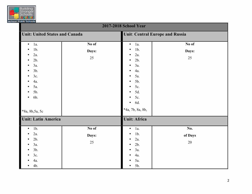
2
2017-2018 School Year
Unit: United States and Canada Unit: Central Europe and Russia
• 1a. • 1b. • 2a. • 2b. • 3a. • 3b. • 3c. • 4a. • 5a. • 5b. • 6b.
*8a, 8b,5a, 5c
No of
Days:
25
• 1a. • 1b. • 2a. • 2b. • 3a. • 4a. • 5a. • 5b. • 5c. • 5d. • 5c. • 6d.
*4a, 7b, 8a, 8b,
No of
Days:
25
Unit: Latin America Unit: Africa
• 1b. • 2a. • 2b. • 3a. • 3b. • 3c. • 4a. • 4b.
No of
Days:
25
• 1a. • 1b. • 2a. • 2b. • 3a. • 4a. • 5a. • 5b.
No.
of Days
20
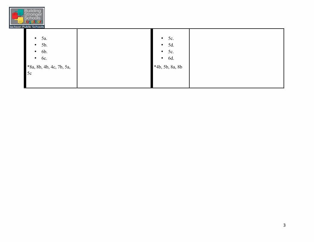
3
• 5a. • 5b. • 6b. • 6c.
*8a, 8b, 4b, 4c, 7b, 5a, 5c
• 5c. • 5d. • 5c. • 6d.
*4b, 5b, 8a, 8b

4
MDE Content Strands, Competencies, and Objectives CONTENT STRANDS Domestic Affairs Global Affairs Civil Rights/Human Rights Economics Culture
STRANDS
The different content strands in social studies combine to give a clear picture of the past and present. Strands also give depth to the social studies curriculum, enabling students to grasp the complexity of events from the past and present and help them acquire critical
thinking skills to make informed choices in the future. The 2011 Mississippi Social Studies Framework is comprised of five (5) essential content strands: DOMESTIC AFFAIRS, GLOBAL AFFAIRS, CIVIL RIGHTS/HUMAN RIGHTS, ECONOMICS,
and CULTURE.

5
MDE Competencies and Objectives
COMPETENCIES AND STRANDS
Content Strand- Domestic Affairs
1. Understand the role of the United States in the world geo-political system.
a. Recognize the effects of U.S. public opinion and U.S. policies on other peoples and countries around the world. (DOK 1) b. Analyze the ways that public policy makers in the United States manage post Cold War tensions between the U.S. as a world
superpower and other countries and organizations as emerging powers. (DOK 3)
Content Strand-Global Affairs
2. Understand the physical environments in the United States and the world along with the processes that shape them and the problems they present to human occupation and use.
a. Identify and explain the concepts and processes that affect physical environments around the world and explain the subsequent patterns and distributions of natural resources and physical environmental changes that result from those processes. (DOK 3)
b. Recognizeproblemsassociatedwiththecomplexinteractionsbetweenhumanactivity and the physical environments around the world (e.g., natural hazards, drought and redistribution of water, agricultural production and food security, movement of air and water pollution). (DOK 2)

6
Content Strand-Global Affairs
3. Understand how population, migration, culture, economics, urbanization, and political factors produce complex networks and systems of human activity around the world.
a. Recognize and explain the concepts and processes (e.g., location, space, economy, development of a ―nation-stateǁ‖, etc.) that shape the patterns and distributions of human activity around the world. (DOK 2)
b. Identify the characteristics of human settlements around the world, sort them into categories (e.g., urban, suburban, rural, gentrified, slums, etc.), and analyze how each type of settlement develops and is sustained through time. (DOK 3)
c. Recognize and explain how the human forces of contact, cooperation, and conflict influence the division and control of earth’s land and resources. (DOK 2)
Content Strand- Civil Rights/Human Rights
4. Understand civil rights and human rights in the contemporary world.
a. Identify and describe the social and economic circumstances of the world’s indigenous peoples and assess the causes and effects of those circumstances. (DOK 2)
b. Describe how processes of structural racism (e.g., social justice, environmental racism, power relations, the gap between rich and poor, migration streams) operate in diverse places and with various groups of people around the world. (DOK 2)

7
Content Strand-Economics
5. Understand economic development, economic globalization and global resource use.
a. Use maps and other geographic representations, tools, and technologies to explain the geographic reasons of economic interactions among people, places, and environments of the world. (DOK 2)
b. Identifyworldpatternsofresourcedistributionandutilizationandevaluatetheimpacts of global economic interdependence (e.g., regional trade agreements, outsourcing, global division of labor). (DOK 3)
c. Categorize human livelihoods (agriculture, manufacturing, services, etc.) and distinguish between wage-earning and subsistence economies. (DOK 2)
d. Identify and analyze the ways in which innovations in transportation and communication networks impact the world. (DOK 3)
Content Strand-Culture
6. Understand the characteristics, distribution, and complexity of Earth’s cultural mosaics.
a. Identify processes of divergence and convergence of cultures. (DOK1) b. Assess the ways in which places and regions contribute to the creation of individual and social identity. (DOK 2) c. Identify major culture regions of the world and explain how the characteristics of each give it a distinctiveness that sets it
apart from the others. (DOK 2)
8
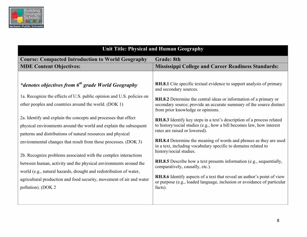
Unit Title: Physical and Human Geography
Course: Compacted Introduction to World Geography Grade: 8th MDE Content Objectives: Mississippi College and Career Readiness Standards:
*denotes objectives from 6th grade World Geography
1a. Recognize the effects of U.S. public opinion and U.S. policies on
other peoples and countries around the world. (DOK 1)
2a. Identify and explain the concepts and processes that effect
physical environments around the world and explain the subsequent
patterns and distributions of natural resources and physical
environmental changes that result from those processes. (DOK 3)
2b. Recognize problems associated with the complex interactions
between human, activity and the physical environments around the
world (e.g., natural hazards, drought and redistribution of water,
agricultural production and food security, movement of air and water
pollution). (DOK 2
RH.8.1 Cite specific textual evidence to support analysis of primary and secondary sources.
RH.8.2 Determine the central ideas or information of a primary or secondary source; provide an accurate summary of the source distinct from prior knowledge or opinions.
RH.8.3 Identify key steps in a text’s description of a process related to history/social studies (e.g., how a bill becomes law, how interest rates are raised or lowered).
RH.8.4 Determine the meaning of words and phrases as they are used in a text, including vocabulary specific to domains related to history/social studies.
RH.8.5 Describe how a text presents information (e.g., sequentially, comparatively, causally, etc.).
RH.8.6 Identify aspects of a text that reveal an author’s point of view or purpose (e.g., loaded language, inclusion or avoidance of particular facts).

9
3a. Recognize and explain the concepts and processes (e.g., location, space, economy, development of a ―nation-stateǁ‖, etc.) that shape the patterns and distributions of human activity around the world. (DOK 2)
3b. Identify the characteristics of human settlements around the world, sort them into categories (e.g., urban, suburban, rural, gentrified, slums, etc.), and analyze how each type of settlement develops and is sustained through time. (DOK 3)
3c. Recognize and explain how the human forces of contact, cooperation, and conflict influence the division and control of earth’s land and resources. (DOK 2)
4a. Identify and describe the social and economic circumstances of the world’s indigenous peoples and assess the causes and effects of those circumstances. (DOK 2)
5a. Use maps and other geographic representations, tools, and technologies to explain the geographic reasons of economic interactions among people, places, and environments of the world. (DOK 2)
5b. Identify world patterns of resource distribution and utilization and evaluate the impacts of global economic interdependence (e.g., regional trade agreements, outsourcing, global division of labor). (DOK 3)
RH.8.7 Integrate visual information (e.g., in charts, graphs, photographs, videos, or maps) with other information in print and digital texts.
RH.8.8 Distinguish among fact, opinion, and reasoned judgment in a text.
RH.8.9 Analyze the relationship between a primary and secondary source on the same topic.
WHST.8.2 Write informative/explanatory texts, including the narration of historical events, scientific procedures/ experiments, or technical processes.

10
6a. Identify processes of divergence and convergence of cultures. (DOK1)
6th Grade World History Objectives- *4a, 5a,5c, 7b. 8a, 8b- (Infuse throughout units)
Big Ideas:
• Differences among perspective, experience, and culture reflect different environments.
• Throughout history, humans have adapted their lives and environment to improve their own quality of life.
• Geographers use different tools to convey knowledge of different locations and demonstrate how that region is unique.
• In defining the geography of a location, one must consider its location as well as its political, economic, social, cultural, and
environmental characteristics.
• The topography, climate, and natural resources of a region influence the culture, economy, and lifestyle of its inhabitants.

11
Essential Questions:
• What makes a place unique and different?
• What are the consequences of technology?
• How can we use social studies tools to study the earth?
• How do physical and human geography affect people, places and regions?
• How are the concepts of time and place vital to the understanding of history and geography?
Instructional Strategies:
GRAPES: When we study and analyze societies and civilizations, we can categorize their features into six significant categories:
Geography, Religion, Achievements, Politics, Economics, and Social Structures.
Students complete a graphic organizer with the acronym GRAPES written vertically. Explain to students that when we study and analyze societies and civilizations, we can use the six significant categories to reinforce the content strands. Have students to work in small groups to complete their definition with a simple image that helps reinforce the concept of geography. Then, generate some specific examples of things that might fall under “Geography.” Continue with the remaining terms (Religion, Achievements, Politics, Economics, and Social Structures).
*Assist students with relating and finding examples of the content strands- (Domestic Affairs, Global Issues, Culture, Civil/Human Rights, and Economics) in each unit.

12
Map Analysis Strategy –TODALSIG acronym: T – title O – orientation [compass rose] D – date A – author L – legend/key including scale S – scale [reminder] and surrounding places I – insets/index when present G – grid system [alpha-numeric; latitude/longitude]
Search for maps of a city or state from different time periods. Compile a list of changes over time and other differences and similarities between the maps.
Socratic Seminar:
The Socratic seminar is a formal discussion, based on a text, in which
the leader asks open-ended questions. Within the context of the
discussion, students listen closely to the comments of others, thinking
critically for themselves, and articulate their own thoughts and their
responses to the thoughts of others. They learn to work cooperatively
and to question intelligently and civilly.
MR HELP reviews the Five Themes of Geography.
• Movement - Help your students understand how all people, including themselves, are dependent on other cultures,
regions, and people in the world. Have your students look around the classroom and see how many products they can find that were manufactured in the United States and how many were manufactured elsewhere. Talk about ways to
travel from one place to another (you can get into abstract ideas like music and literature). Talk about what happens
when people are not able to communicate.
Students can answer the following while studying movement:
How can visitors get to and from this place (airports, highways,
train stations)? How do goods or ideas from this place affect people in other places?
• Regions - Compares and defines characteristics that make
places similar to or different from other places
Students can answer the following while studying regions: What foods, activities, or special interest is this region known
for? How are the people here similar to or different from other people in nearby places?
• Human-Environment Interaction – includes descriptions
of how humans adapt to and/or change the physical environment, including industries and agriculture, to
improve lifestyle or survival.
13
Students can answer the following while studying HEI:
How can visitors take care of the environment here? What should visitors know about the environment here?
• Location - Includes determining both absolute location
[latitude, longitude; address] and relative location [in relation to a fixed point; cardinal/intermediate directions]
Students can study location by answering the following: In what state or country is this place? What are its latitude and longitude? What other interesting places are near?
• Place - Identifies and distinguishes the physical and human
characteristics of a given place including climate, population, vegetation, water, and landforms; natural resources.
Students can study place by answering the following: Who lives here? What kinds of businesses or activities can people visit? What kind of clothes do people need for the land or climate?

14
Debate:
Debate is a structured form of argumentation that requires participants to engage in research, develop listening and oratory skills, and think critically. Debating can be employed as an instructional strategy wherever the learning material and circumstances are open to opposing points of view. Debates may be viewed or read to contribute additional perspectives on a classroom topic.
Format: Affirmative- (For) presents case • Negative- (Against) presents case • Affirmative and negative respond to one another • Affirmative summarize and concludes • Negative summarizes and concludes
Placemat Strategy:
Students work together to complete a task in groups of four. Each student spends a few minutes brainstorming, and writing their own statements about a topic, in their own space. Then, a group leader writes the consensus statements (the things students agree is true) in the center. This practice is called “Placemat Consensus.” Example:
Gallery Walk:
1. Create four questions or prompts about the current topic of study, and write each one on a piece of chart paper or on a white board. Hang or place the questions or prompts in various places around the classroom to create six stations. Images, documents, problems, or quotes may also be used.
2. Group students into teams (depending on the size of the class). Each group should start at a different station.
3. At their first station, groups will read posted information and write the group’s responses on the chart paper or white board. Hold all students accountable for contributing.
4. After three to five minutes, have the groups rotate to the next station. Students read and discuss the previous group’s response and add content of their own. Repeat until all groups have visited each station. (It is important to monitor the stations while the students participate.
5. You may also need to clarify if students don’t understand or misinterpret what is posted at their station.)
6. Bring the class back together to discuss what was learned and make final conclusions about what they saw and discussed.

15
Close Reading: Guide students’ investigation of a piece of text. Guide students’ investigation of a piece of text (a complex passage), with multiple readings and annotations. Common annotations include:
• Underlining major points • Vertical lines in the margin to denote longer statements that are too long to be underlined • Star, asterisk, or other doodad in the margin to be used sparingly to emphasize the ten or dozen most important statements • Numbers in the margin to indicate a sequence of points made the author in development of an argument. • Numbers of other pages in the margin to indicate where else in the book the author makes the same points • Circling of key words or phrases • Writing in the margin, or at the top or bottom of the page, to record questions (and perhaps answers) a passage raises in your mind
Get the Gist (Who, What, When, Where, Why, How, Summarize) Anticipation Guide:
• Select statements for the anticipation guide. The most effective statements relate to universal themes and are phrased in ways that make sense when applied to events in the unit of study and to situations in students’ lives.
• Prepare a handout or graphic organizer that structure students’ responses by asking them to decide if they strongly agree, agree, disagree or strongly disagree with the statement, and then explain why.
• Have students to reflect and review their anticipation guides after completing a text, noting how their experience with new material might have changed their thinking. Reflections can be in writing and/or through discussion.
Jigsaw Jigsaw is a cooperative learning strategy that enables each student of a "home" group to specialize in one aspect of a topic (for example, one
group studies the theme of Place, another group studies the theme of Regions). Students meet with members from other groups who are
assigned the same aspect, and after mastering the material, return to the "home" group and teach the material to their group members.

16
OPTIC
• O- Conduct a brief OVERVIEW of the visual or graphic. This should be in the form of a brief paraphrase or summary.
• P- Parts: Key is on the PARTS of the image by reading the visual as a text, looking for literary techniques such as imagery, simile,
metaphor, symbol, and irony.
• T-Title: Read the TITLE or caption of the visual (if one is present) so that you are clear on the subject it is covering.
• I-Interrelationships: Use the title as your theory and parts of the visual as your clues to detect and specify the
INTERRELATIONSHIPS in the graphic.
• Conclusion: Draw a CONCLUSION about the visual as a whole by stating its theme or the argument its making.
Accountable Talk
Accountable talk is a strategy that gets students talking with one another, listening to one another and building off one another’s conversation to further develop oral language skills and vocabulary. This strategy asks students to respond to and further develop what others have said, which requires engaged listening and evidence from another person’s words.
*Examples of Accountable Talk Stems include: o I disagree with you because… o The evidence to support my statement is… o I predict _______ because…

17
SOAPStone-‐‑ To analyze any piece of writing, it is essential to know the subject of the piece, the occasion for its being written, the audience for whom it is written, the purpose of the piece, and the actual speaker (may differ from the author). The SOAPS strategy can
be useful when analyzing primary sources. Who is the Speaker?
• Who is the speaker? Identification of the person (or group of people) that wrote this text: what is the speaker’s age, gender, class, or education?
• Identify the main voice within the text. • What can you tell or what do you know about this person’s role in the text?
What is the Occasion?
• Identify the time and place of the text. What is the current situation? • Is it a personal event, a celebration, an observation, a critique, or…? • Identify the context of the text.
Who is the Audience?
• The readers to whom this text is directed. • The audience may be one person, a small group, or a large group. • Does the speaker specify an audience? • What assumptions exist in the text about the intended audience of this text?
What is the Purpose?
• What is the purpose for the passage/text? • What is the message? • Why did the author write it? What is the author’s goal? • How does the speaker convey the message?
What is the Subject?
• The topic, content, and ideas included in the text. • Can you identify and state the subject in a few words? • Is there one or more than one subject? • How does the author present the subject? Does s/he introduce it immediately or not? Is the subject explicit or implicit?
AUTHOR’S TONE
• Clarify the author’s attitude toward the topic/subject. • Is the author emotional, objective, or biased about this topic/subject? • What types of details, language, and sentence structure “tell” the author’s feelings about the topic/subject? • If you were the author and were to read the passage aloud, describe the tone of his/her voice.

18
Vocabulary Strategies:
Marzano Strategy: (Example of template included in this unit plan)
• Provide a description, explanation, or example of the new term
• Ask students to restate the description, explanation, or example in their own words
• Ask students to construct a picture, symbol, or graphic representing the word
• Engage students periodically in activities that help them add to their knowledge of the terms in their notebook.
List-Group-Label
After selecting a main concept in a reading passage:
1. List: Have students brainstorm all the words they think relate to the topic. Visually display student responses.
2. Group: Divide your class into small groups. Each group will work to cluster the class list of words into subcategories. As groups of words emerge, challenge your students to explain their reasoning for placing words together or discarding them.
3. Label: Invite students to suggest a title or label for the groups of words they have formed. These labels should relate to their reasoning for the grouping.
Academic Vocabulary:
Geography, culture, fauna, flora, latitude, longitude, equator, antebellum geologists, maize, sharecropper, region, natural resources, elevation, weather, erosion, processes, human environment interaction, place, location, population density, population, ecosystems, economics, topography

19
Formative Assessment Strategies:
v Analogy Prompt- Present students with an analogy prompt: (A designated concept, principle, or process) is like ___________because_________________.
v Exit card- Exit cards are written student responses to questions posed at the end of a class or learning activity or at the end of the day.
v Self-Assessment- A process in which students collect information about their own learning, analyze what it reveals about their progress toward the intended learning goals and plan the next steps in their learning (with teacher guidance). Students can also complete Student Data Notebooks-A tool for students to track their learning: Where am I going? Where am I now? How will I get there?
v Journal Entry- Students record in a journal their understanding of the topic, concept, or lesson taught. The teacher reviews the entry to see if the student has gained an understanding of the topic, lesson, or concept that was taught.
v Quick Write- Students respond in 2-10 minutes to an open-ended question or prompt posed by the teacher before, during, or after reading.

20
Performance Task:
G-The goal is to acquire a new sports team in your city.
R-You are the mayor of the city.
A-The audience consists of the team’s owners, investors, citizens, and members of the city council.
S-You are trying to convince the audience to sponsor and support a sports team in your city.
P-Write a two-page proposal stating the reasons why you want the team, giving examples of how your city is unique (Place), describing the location (Location), explaining how goods, employees, and tourists supporting the team will get from one place to another, describing the various ways the city will benefit from the sports team and how the team will affect life in your city, and how the climate and features of the city will bring in more revenue for the team. Include your disaster plan in case of a weather emergency and/or weather condition. Draw a map of your city to provide a visual to the audience. S-Standards: 2a, 2b, 5a, 8a, 8b, WHST.8.2

21
Instructional Plan:
Day One/Two:
MDE Objectives: 4a, 5a, 5b,8a, 8b
MS CCR Standards: RH.8.1, RH.8.2
Anticipatory Set/Introduction to the Lesson:
(Class Starter) Students can complete an ABC Brainstorm/Summary handout (included in this unit plan) and write what comes to mind when they think about geography and the United States. Provide students with a Word Splash with words such as mountains, beaches, canyons, and farms to help frame their thoughts if needed. Give students a copy of the image from San Francisco or project it from the board. (Image and template included in this unit plan.)
Understanding Lesson Purpose and Student Outcomes:
Lead a brief discussion based on students’ responses. Review the Big Ideas, Essential Questions, Learning Targets/Goals, and the Performance Task with students.
Teacher Input/Modeling: Direct Instruction of Vocabulary-The teacher will provide direct vocabulary instruction by providing students with vocabulary words, definitions, and visual representations. Students will complete the chart with their own definition and visual representation. An example is included in unit plan. *See Marzano template included in this unit.
Provide background information geography and geographer’s tools using a Power point presentation. Explain how geography affects life in the United States. Provide real world examples for student such as natural resources and how they are used. Include a map of the world in your presentation to review location with students. Provide students with an image from the United States, an article of physical geography, and a Cornell Notes template. Model for students how to complete the Cornell Notes template using the article and the image, and model how to conduct the Gallery Walk.

22
National Geographic Article
Link to Article on Geography
Guided Practice: Gallery Walk- Devise several questions/problems and posts related to the physical geography of the United States. Images can also be used for students to write about. Have each question/problem at a different table or at a different place on the walls. Students form as many groups as there are questions, and each group moves from question to question (hence the name “walk”). After writing the group's response to the first question, the group rotates to the next position, adding to what is already there. At the last question, it is the group's responsibility to summarize and report to the class. Students should use the Cornell Notes template and the article for assistance. Rotate from group to group to check for student understanding. `Have students to compare the geography of Haiti to where they live.
Examples of Gallery Walk Posts: How are Landforms Beneficial? How are the regions determined? What does geography affect life for the people in the U.S.? How might life in the U.S. be like a melting pot?
Closure: Have each group to stand at a question stem or post. Have each group to read their responses for each question or post and elaborate. Have other groups to ask clarifying questions or add more insight to responses. Clarify any misconceptions.
Independent Practice: Complete the summary portion of the ABC Brainstorm template. Write two paragraphs summarizing today’s lesson on geography and how geography affects your life.

23
Term
Definition
Non-‐‑Linguistic Representation
Student Definition
Student Non-‐‑Linguistic
Representation
geography
The study of the physical features of the earth and its atmosphere, and of human activity as it affects and is affected by these, including the distribution of populations and resources, land use, and industries

24

25

26

27
Day Three/Four
MDE Objectives: 1a, 2a, 2b, 3a, 6a, 7b
MS CCR Standards: RH.8.1, RH.8.2, RH.8.4
Anticipatory Set/Introduction to the Lesson:
Show students a video on the Five Themes of Geography. Have students to look for how the themes are used to study the world and write three examples of how the video displays each theme. Link to video: Five Themes of Geography
Teacher Input/Modeling:
The teacher will provide background information using an article about on geography and the 5 Themes of Geography (article included in unit plan). The teacher will provide direct vocabulary instruction (Marzano strategy) by providing students with vocabulary words, definitions, and visual representations. (Students will complete the chart with their own definition and visual representation.) The teacher will relate information from the video of how geography affects culture and how people live. The teacher will model how students are to complete the Jigsaw, Gist activity (to determine the central ideas), and how to look for word meanings during the guided practice phase. The teacher will also model for students how to respond to the scenario activity before they began independent practice.
Guided Practice:
In small groups, assign students a reading selection on the 5 Themes of Geography. Have each group member to specialize in one aspect of the 5 Themes of Geography (for example, one group member studies the theme of Place, another group member studies the theme of Regions). Have students meet with members from other groups who have been assigned the same aspect, and after mastering the material, return to the "home" group and teach the material to their group members. Students can use the Gist handout to help organize content, cite textual evidence, and determine the central idea. Note the details from the reading selection that gave the meaning of unknown words. Note: Provide students with a list of words or have them pull the words out of the article.

28
Closure: Give students an exit card with the following:
v What three things did you learn in today’s lesson that square your thinking?
v What are the three most important new ideas you learned in this unit?
v What is one thing that you are not sure about or that you still have a question about?
*Have students to present their information before leaving classes to clarify misconceptions.
Independent Practice: Given various scenarios and postcards, students will write the theme described and list textual evidence from the article on the next page to defend their answer choice.
Example: “I am having an amazing time in New York. I have visited beautiful lakes and gorgeous mountains. We then went to the south and rode on the subway which cuts right under the city! We went to Ellis Island today and learned all about how New York has such a diverse population because about 25 million immigrants entered the United States from here. Wish you were here!”
Homework Suggestions:
• Have students find examples from current events and news reports of the Five Themes of Geography and relate to their community or country.
• Have students to write about what they are learning in class. • Have students to complete analogy prompts where they compare the United States to another place or an object.

29
Five Themes of Geography –
The Five Themes of Geography were developed by National Geographic Society in 1986. They are a very simple, but useful framework for the study of a dynamic earth – for the study of geography. They are the framework around which all elementary and secondary-level textbooks have been written. LOCATION – Location answers the question, “where is it?” There are two categories of location: 1. Absolute location – the exact location of a place on the geographic grid. Nothing is more exact than precise coordinates of latitude and
longitude; however, a complete street address with zip code is usually considered to be an expression of absolute location also. 2. Relative location – Where a place is located as compared with other places. Relative location is given in the terms of distance and
direction. It also may make reference to easily recognized or familiar landmarks, both natural and man-made.
PLACE – Studying place answers the question, “What is it like?” The factual information that can describe a location is studied when the geographer studies place. Place studies those physical and human features of a location that give it a distinctive character. Geographers also study place to learn about the people who live there. There are two categories of place: 1. Physical place – The physical characteristics of the environment are studied: resources, climate, landforms, water features, natural
vegetation, and the associated wildlife. Anything distinctive which comes from nature contributes to an understanding of physical place. 2. Human (cultural) place – The distinctive human elements of the location are studied: occupations, recreation, settlement types and
patterns, political, economic, and religious beliefs, ideas, languages, world view. Again, the features must be distinctive in some way and must be the product of human efforts.

30
HUMAN-ENVIRONMENT INTERACTION – Studying interaction answers two questions. (1) How are human activities influenced by the physical place (natural environment)? (2) How are humans altering the physical place (natural environment) to achieve their objectives? So there are two categories of human-environment interaction also. Interaction is greatly influenced by two elements of culture: world view and technology. The world view taught to people raised in a particular culture influences how they view the physical environment and how they will interact with it. The level of technology of a culture determines the degree to which the people can, if they choose, alter physical place (natural environment). 1. The first category of interaction is human adaptation to natural conditions. Building shelter from the cold and rain and wearing warm
clothing in a cold climate are examples of humans adapting to natural conditions. In some cultures, people take a rest during the warmest part of the mid-day. This often occurs or may have originated in an area where the mid-day was exceptionally warm and uncomfortable. Migrating people may carry that culture trait to other places and continue to practice it even though the mid-day in the new location may be very pleasantly comfortable – that is why we look to where the custom originated to find the adaptation.
2. The second category of interaction is human alteration of natural conditions. Whenever humans use their technology to change what
nature has provided, they are engaged in this second type of interaction. When humans dam rivers, blast tunnels through mountains for roads or railroads, when humans change the composition of gases in the atmosphere (global warming), they are changing conditions. This must be done with great care and forethought, because the world has a very delicately balanced ecosystem.
MOVEMENT – Studying movement involves identifying and measuring the exchange of products, people, information, and ideas among places. There are two categories of movement: 1. Material movement - The most obvious movement involves the use of some type of land, water, or air vehicle. This involves moving
people, animals, or other material things. 2. Non-material movement - The second category involves less visible forms of movement and may be even more important than the first
category. The transmission of energy and information through electric wires or fiber optics is a very important form of movement which can alter places by influencing the type and quantity of human-environment interaction. The exchange and/or transmission of ideas from one place (culture) to another may not be easily seen until the transmitted cultural elements have become well established.

31
REGION – Regions provide a framework within which to see the other four themes interacting. Regions are areas that have some feature or features in common – some unifying element or elements. There are two categories of region: 1. Formal Region: Many features can be used to delineate regions formal regions. These are regions which share one common feature or a
set of features. There are landform regions, climate regions, environmental regions (biomes), language regions, political regions, economic regions, religious regions, culture regions, etc. A formal region defined by a combination or set of features might be that area in which at least 80% of the people speak French as their first language AND 80% of the people consider themselves practicing Roman Catholic Christians.
2. Functional Region: The functional region’s unifying feature is an interactive system. The hinterland of a commercial city would be a functional region. An urban area could also be seen as a functional region. An ecosystem might also be viewed as a natural functional region. The defining characteristics are the interconnected parts.

32

33
Day Five/Six:
MDE Objectives: 1a, 2a. 4a, 4a, 5a, 6a, *8a
MS CCR Standards: RH.8.1, RH.8.2, RH.8.4
Anticipatory Set/Introduction to the Lesson:
Students will complete a quick write responding to the prompts “How is the city or state you live in unique?” “How would give the relative location of your neighborhood or community?” “How do people affect your neighborhood or community?”
Teacher Input/Modeling:
After listening to the students’ responses, the teacher will lead a discussion on the 5 Themes of Geography (using the textbook or an article on the themes), and provide examples of how they are used to study the world. Explain to students the significance of all themes. Pose questions that would allow students to see how the themes are beneficial and analyze multiple perspectives of using them when studying the earth oppose to not using them.
Model the group activity for students using the information in the “Instructional Strategies” section of this unit plan (suggested). This activity can be done with students moving from station to station or by the teacher moving the work supplies and assignments. Model what students are to do with the “Where Am I” booklets.

34
Guided Practice: Station Activity
Station 1- Location- At this station, students will plot the absolute and relative location of Jackson.
Region- At this station, students will write how the theme of region applies to Jackson.
Station 2- Place- At this station, students will explain how the theme of Place can be used to study Jackson, and provide examples.
Station 3- Movement- At this station, students will study a map of Jackson and the theme of movement. Have students to write about how the road system affects the movement of people, goods, and ideas from one place to another.
Station 4- Human-Environment Interaction- At this station, have students to read about the physical features of Jackson and write how those features affect people who live in Jackson.
Closure: Have students to choose a place of interest to demonstrate mastery of applying three of the Five Themes of Geography.
Example: Students can write the absolute location of Paris (Location), explain the physical features that make Paris unique (Place), and explain how goods, ideas, and people affect life in Paris (Movement).
Independent Practice: Students can create “Where Am I” booklets. The booklet should provide examples on a particular place and give clues on the location, the specific unique physical/political features of the place, how various factors influence life in that area, which region the place is a part of, and how goods, ideas, and people have been factors to the chosen place. Explain how these factors have influenced culture in various places. Students are to choose cities that interest clues and give clues of their choice (based on understanding).
*Provide students with a rubric and allow them to assess themselves based on the criteria in the rubric. Ensure that students express the big ideas and concepts accurately, provide visual images, make real world connections, and cite evidence from learning resources.

35
Day Seven/Eight:
MDE Objectives: 2a, 3b, 5a, 8b
MS CCR Standards: RH.8.1, RH.8.2, RH.8.4
Anticipatory Set/Introduction to the Lesson:
Have students to complete KWL+ graphic organizer, and write what they already know about climate and weather under the K section. (Template included in this unit plan)
Teacher Input/Modeling:
The teacher will lead a discussion on climate and weather. The teacher will explain the similarities and differences in climate, and weather and provide examples of both. The will also make connections to real world by describing the climate of Mississippi and the various places in the United States, as well as economic . The teacher will explain to students why people move and how various factors influence where people live. Discuss weathering and erosion with students and provide examples. Model how students are to read and annotate article on climate looking for the central ideas and determining the meaning of selected terms. The teacher will model how to complete the W and L+ section of the graphic organizer. The W section should include what students what to learn, and the L+ section should include what students learn (inferences) and where they got the information. Show students how to cite information.
Article on Climate and Weather from NASA
Guided Practice:
Have students to work with a partner to “give one and get one” inference about climate and weather. Students should use their textbooks and the article to gather and discuss the information on climate and weather in the U.S. (and how they affect our lives).
*See example on the next page.

36
Example of KWL+ organizer:
KWL+
Know Want to Learn Learned + (Cite Evidence)
Weather
Climate
Closure: Students will present information from their graphic organizers to the class and review today’s lesson. The teacher will clarify any misconceptions and have students provide real world connections.
Independent Practice: Have students answer open ended questions about how climate affects their lives.
For example: “How does the climate of Alaska affect life there?” “Why do people use irrigation systems?”

37
Day Nine/Ten:
MDE Objectives: 2b, 5a, 8a, 8b
MS CCR Standards: RH.8.1, RH.8.2, RH.8.4
Anticipatory Set/Introduction to the Lesson:
Have students to complete the List Label Group strategy using the following terms: landforms, climate, regions, location, and human-environment. Students should categorize terms and think of at least five more under those headings. Assist students with adding more terms based off what they have learned throughout the unit.
Teacher Input/Modeling:
The teacher will review information on the Five Themes of Geography, climate and weather, and weathering with students using a map of the U.S., a power point presentation, an article, and images. The teacher will lead a discussion from a video on weathering- Weathering and Erosion. The teacher will conduct a Think Aloud while modeling the Pass the Poster strategy and Accountable Talk.
The teacher will model how use “Where Am I” booklets that students turn to review major concepts as well. The teacher will model the “pass the poster” activity in which students will write NEW information on each topic on chart paper after discussing with group. Ensure that students are discussing information and staying on task. Provide Accountable Talk stems for students. The stems can be found under the Instructional Strategies section.
38
Guided Practice:
Working in groups, students will call out clues for group members to determine location. Students will also work in groups to review major concepts from the unit by “passing the poster.”
The topics for “Passing the Poster” can include: Climate and Weather- Physical Geography-Human Geography- Five Themes of Geography. Label four sheets of chart paper (per class) with one topic for students to pass after five minutes.
Closure:
Independent Practice: Have students to complete a writing assignment using their textbook and/or an article with the following prompt:
“How does the topography, climate, and natural resources of a region influence the culture, economy, and lifestyle of its inhabitants?”
Students can use the “It says, I say, and so….” organizer to help frame their writing.
Question It Says… I Say… And So…

39
Day Eleven/Twelve:
MDE Objectives: 2a,2b, 3c, 5a, 5b
MS CCR Standards: RH.8.1, RH.8.2, RH.8.4
Anticipatory Set/Introduction to the Lesson:
On colorful large index cards, have students to create a political cartoon about weathering. Political cartoons should explain and show the breaking down or dissolving of rocks and minerals on Earths surface. Water, ice, acids, salt, plants, animals, and changes in temperature are all agents of weathering and should be displayed in written and visual form.
Guided Practice:
Project the following on the board or the Smart Board: “Geography involves…”
Have students participate in a “Find Someone Who” activity in which students will find other students who can complete the statements on their paper and give examples. Suggestions for statements are below:
• Plotting absolute and relative location • Explaining how humans affect the environment • Determining what makes a region • Explaining unique characteristics of a place • Analyzing why certain places are densely populated
Closure:
Students will reflect on the importance of geography in their learning logs/journals.
Independent Practice: Test on Human and Physical Geography

40
Differentiation:
For students who perform or read below the grade level:
• Provide sentence starters to frame their writing with writing activities • Provide a partially filled graphic organizer or handout for the Gist activity • Provide a closed activity (paragraph) for students whose language is extremely limited for Quick Writes • Supply a word bank and definitions when students are reading texts • Give a model or exemplar of how the finished product should look
Students who are ELL:
• Give students many opportunities to have extended interaction (such as doing ‘jigsaw’-type activities) with peers of varying English proficiency levels, who can provide ELLs with a range of models for how to use English words or structures appropriately.
• Provide ELLs with strategic types of scaffolding, such as graphic organizers, visual aids, peer help, or home language help, and removing these supports as students’ skills develop
• Provide them with relevant background knowledge about a topic to be discussed in class, or activate their existing knowledge of a topic
• Assist ELLs with learning new vocabulary through extended discussion with their classmates after reading or between multiple readings
For students who are advanced learners:
• Have students to make text to text and text to world connections to their articles • Provide students with a challenge question or problem to investigate using multiple texts • Give students scenarios to consider and respond to, citing evidence • Pose a challenge question or task that requires students to think beyond abstract ideas and new use of the information.

41
Resources:
Ø Pearson Success Net “Geography: Building a Global Perspective” textbook and online resources Ø National Geographic Images from the United States Ø NASA article on Climate and Weather Ø Weathering Video- Watch, Know, Learn Video on Weathering Ø National Geographic Video on Climate and Weather Ø Gist Template Ø Primary Source Documents and Images – Docs Teach Ø Lessons Using Primary Source Documents-The Stanford History Education Group Ø Historical Thinking (U.S. History texts and resources) Ø The Teaching Channel Ø News ELA Ø Library of Congress Ø Mississippi Department of Archives and History Ø National Geographic Lessons Ø Geography Tools Ø Geoknow.net Ø National Geographic Ø Ready.Gov Ø Human Geography Links Ø Cybraryman Immigration Information Ø CNN Students News (view prior to showing to students/link to MDE objective) Ø Current Event articles that are relevant to MDE Framework Ø Mississippi Department of Archives and History