
Web 2.0/Gov 2.0 Created by Bill Finnerty Cumberland County, PA May 2009.
4-1
12/1/2008
CHAPTER 4
History Past & Present
Cumberland County has a rich history that continues to contribute to the heritage and identity of
the county today. Events in the past have shaped the county as it has evolved over time. It is
important to understand and appreciate the past in order to plan for the future. The
development of this chapter was supported by a grant from the Pennsylvania Historical and
Museum Commission.
The Earliest Native Americans
The first human inhabitants of the region arrived between 12 and 18 thousand years ago.1
We
know very little about them except they were probably related to the Algonquian tribes that
settled north of Pennsylvania. These early peoples were most likely nomadic hunters living in
temporary or base camps. No villages of these ancient tribes have been found in Cumberland
County, but many artifacts have been discovered to verify they populated the region. Artifacts
found in the Cumberland Valley include notched arrow and spear points and grooved hatchets
and axes of Algonquian origin.2 Approximately 3,000 years ago these native peoples began to
cultivate crops, which included Indian corn or maize. They also grew tobacco, which was used
for pleasure as well as incense in religious rituals. The cultivation of land led to a more sedentary
lifestyle and contributed to the establishment of permanent settlements.
The remains of these early Native Americans have been found in Cumberland County, generally
near water sources. The discovered artifacts indicate that they occupied the area for a long period
of time and they must have been numerous.3 These original Algonquian tribes are probably
ancestors of the Delaware Indians who migrated east to the Delaware River.
A legacy of the early inhabitants is their language. Algonquian was the common language group
used by their descendents and several local place names have their origin in that language. For
instance, the three major water bodies related to Cumberland County are of Algonquian origin.
The Conodoguinet Creek has been translated to mean, ―for a long way nothing but bends,‖
referring to the meandering nature of the stream.4 The original name of the Yellow Breeches was
Callapatscink, which has been translated to mean, ―where the waters turn back again‖.5 This is
descriptive of the lower stream where the general eastern flow turns back to the west at certain
bends along its course. The Susquehanna River has had various translations. Two common
translations for the river are ―falls stream‖ and ―muddy river‖.6
1 Paul A. W. Wallace, Indians in Pennsylvania 2
nd ed. (Pennsylvania Historical and Museum Commission, 1981) 4.
2 Dr. George P. Donehoo, History of Cumberland Valley in Pennsylvania Vol. 1 (Harrisburg, Pa: The Susquehanna
History Association, 1930) 26. 3 Ibid, 26.
4 Dr. George P. Donehoo, History of Indian Villages and Place Names in Pa. (Harrisburg, Pa: The Telegraph Press,
1928) 42. 5 Robert Grant Crist, Lower Allen Township: A History (Camp Hill, Pa: Planks Suburban Press, 1993) 8.
6 Ibid, 11. Paul A. W. Wallace, Indians in Pennsylvania, 12.

4-2
12/1/2008
Susquehannocks
The first written description of Native Americans living along the Susquehanna River, which
included the Cumberland Valley, was by John Smith in 1608. During his exploration of the
Chesapeake Bay, John Smith sailed up the Susquehanna River to the fall line in Maryland. He
then traveled by land to a Susquehannock village in present day Lancaster County.
Although John Smith did not travel farther north, he did obtain information concerning the
locations of several large Susquehannock towns near the Susquehanna River. In 1612, he
mapped these towns and showed the Susquehannock town of Utchowig at the present site of
Carlisle Borough in Cumberland County.7 The location and existence of this Susquehannock
town has been disputed by historians and no physical evidence has ever been found. The only
Susquehannock village found in Cumberland County was discovered in 2007 near the
Susquehanna River in Lemoyne Borough. The discovery was made while improving the
Norfolk-Southern Railroad. The village site is estimated to have been occupied between 1600
and 1625.8
The Susquehannocks were a powerful tribe that at one time commanded a large part of the
drainage area of the Susquehanna River. They were a well-organized military people who
seemed to be perpetually at war with surrounding nations. In 1633, the Susquehannocks were at
war with the Delaware and in 1656 they were at war with the Iroquois. During this period a small
pox epidemic swept through the tribe and reduced its population.9 By 1675, the Susquehannocks
were broken up and driven out of Pennsylvania by the Iroquois.
As a result of this war, the Iroquois gained control of the Susquehannocks’ land, which included
the Cumberland Valley. The Iroquois did not settle the region but allowed other tribes to inhabit
the area. This opened the way for Delaware from the east and Shawnee from the south to migrate
to the region.
Shawnee
With the defeat of the Susquehannocks by the Iroquois, Shawnee tribes began to settle in
portions of Cumberland County. The Shawnee migrated to the region from the south and west
and were accepted by the Iroquois, who controlled the Susquehanna valley.
The Shawnee had established villages in Cumberland County around 1698.10
Most were
concentrated on the west shore of the Susquehanna River, between the Conodoguinet and Yellow
Breeches creeks. Many settled near the mouth of the Yellow Breeches Creek at present day New
7 Dr. George P. Donahoo, History of Cumberland Valley in Pennsylvania, Vol. 1 (Harrisburg, Pa: The Susquehanna
History Association, 1930) 26. 8 Pennsylvania Historical and Museum Commission, Bureau of Historic Preservation, July 2008.
9 Rev. Conway P. Wing, History of Cumberland County, Pennsylvania (Philadelphia, Pa: James D. Scott, 1879) 13.
10 Donahoo, History of Cumberland Valley in Pennsylvania, Vol 1, 8.
4-3
12/1/2008
Cumberland Borough and some records of the time refer to the stream as Shawnee Creek.11
There is also evidence of a small Shawnee settlement that exited near present day Carlisle.12
An influential member of the Shawnee tribe that occupied the West Shore was Peter Chartier.
His father was a French refugee and his mother Shawnee. He became an interpreter between the
settlers and the tribes, engaged in trade, and occasionally represented the Shawnee in diplomatic
relations.13
By 1720, settlers were crossing the Susquehanna River from Harrisburg and illegally
settling in Cumberland County. This influx of settlers led to conflicts and worsening relations
between the two groups. By 1727, most of the Shawnee had left Cumberland County and
migrated to western Pennsylvania and Ohio. Peter Chartier accompanied the western migration
and eventually supported the French in their conflicts with the British.
In 1732, The Penn family offered Chartier and the Shawnee tribes land in Cumberland County at
the site of their original settlements. The reserved land was called ―Indian Manor‖ and was
offered to the Shawnee in order to discourage their alliance with the French. The Manor was
bounded on the north and south by the Conodoguinet and Yellow Breeches creeks, and the east
by the river, and on the west by a straight line running between the creeks in the vicinity of St.
Johns Church Road. 14
Chartier never accepted the offer of land on behalf of the Shawnee. By 1745 he had sided with
the French in their conflicts with the British and was leading raids against Pennsylvania traders
and settlements. In 1762 the Shawnee officially relinquished their claim to the land reserved for
them in Cumberland County. The reservation was then renamed ―Manor of Lowther.‖
Trails
Prior to the Shawnee occupation in 1698, there is little evidence of permanent Native American
settlements in Cumberland County. The Cumberland Valley, though, was a heavily traveled
transportation corridor. Numerous Indian paths crossed Cumberland County and many
intersected at the present site of Carlisle Borough. These paths provided channels for trade and
cultural diffusion and were dry, level, and direct paths in their design.15
Many of the County’s
existing roads follow the old Indian paths.
One of the major paths through Cumberland County was the Great Trail. It crossed the
Susquehanna River at Paxtang (Harrisburg) and went to Letort’s Spring (Carlisle), Mt. Rock, Big
Spring, and Shippensburg. After leaving the County it continued south through Chambersburg,
across the Potomac River, and eventually into Virginia and the Carolinas. Present-day U.S.
Route 11 generally follows the old path.
11
Robert Grant Crist, Lower Allen Township, A History, (Camp Hill, Pa: Planks Suburban Press, 1993) 18. 12
Paul D. Hoch, Carlisle History and Lore: Its People, Places and Stories, (Carlisle, Pa: Cumberland County
Historical Society, 2003) 90. 13
Robert Grant Crist, Lower Allen Township, A History, (Camp Hill, Pa: Planks Suburban Press, 1993) 18. 14
Ibid, 18. 15
Paul A. W. Wallace, Indian Paths of Pennsylvania (Harrisburg, Pa: Pennsylvania Historic and Museum
Commission, 1971) 2.

4-4
12/1/2008
The Great Trail has been known by other names such as the Virginia Path, Potomac Road, and
Warriors Path. This trail was a war path for the Iroquois into the Carolinas and was used by
warriors in their expeditions against the Cherokee and Catawba. The course of the Warrior Path
through the Cumberland Valley may explain why there were so few American Indian villages in
Cumberland County prior to the Shawnee occupation in 1698. The Susquehannocks, who
previously controlled the region, were an enemy of the Iroquois, and it is unlikely they would
establish settlements near an Iroquois warpath.16
The Walnut Bottom Path was a branch of the Great Trail and generally followed the current
Walnut Bottom Road between Carlisle and Shippensburg. The path left Carlisle about where the
Dickinson Law School is now and ran southwest through Mooredale, Walnut Bottom, and Lees
Crossroads to Shippensburg where it rejoined the Great Trail.
The Frankstown Path went from Harrisburg to Kittanning and crossed Cumberland County from
east to west. It was the most important and most frequently traveled trail across Pennsylvania’s
mountains.17
There were many variants of the path depending on the season and load carried. In
Cumberland County the most common route was from Camp Hill to Carlisle along current U.S.
Route 11. An alternative route was from Camp Hill through Mechanicsburg to Carlisle following
Trindle Spring Road (Pa Route 641). After the two branches joined at Carlisle, the Frankstown
Path ran west through Mt. Rock, Newville, Newburg, and then entered Franklin County and
crossed Blue Mountain at Roxbury Gap.
The New Path went from Middlesex to Shirleysburg and was a short cut on the Frankstown Path.
It was used frequently by traders after 1749. The path ran north from Letort’s Spring near
Carlisle and crossed the Conodoguinet Creek at Middlesex. It then continued north through
Sterretts Gap to Shermans Creek in Perry County. The path then generally followed Shermans
Creek west until it linked with the Frankstown Path.
Raystown Path was another trail providing access to western Pennsylvania. It went from
Harrisburg to Pittsburgh and followed the route of the Great Trail through Cumberland County
(U.S. Route 11). After passing through Shippensburg and out of the county, the path split with
one branch running west to Orrstown and the other branch running southwest toward Fort
Loudon.
16
Dr. George P. Donehoo, History of Cumberland Valley in Pennsylvania,Vol. 1, (Harrisburg, Pa: The Susquehanna
History Association, 1930) 26. 17
Paul A. W. Wallace, Indian Paths of Pennsylvania (Harrisburg, Pa: Pennsylvania Historic and Museum
Commision, 1971) 49.

4-5
12/1/2008
The Conoy Path was named for a Conoy Indian town located at present-day Bainbridge,
Lancaster County. The path went from Bainbridge to Carlisle and was used as a connector trail
to the many paths that intersected at Carlisle. From Bainbridge the path ran up the east bank of
the Susquehanna and crossed the river at York Haven. It then went northwest through York
County and entered Cumberland County about a half mile west of Lisburn. It continued through
Bowmansdale and ended at Carlisle, generally following existing Lisburn Road.
Early Settlers
James Letort has been noted as the first European settler in Cumberland County.18
He was a
trader who could speak the Shawnee language. In 1712 he obtained a license to trade with the
Shawnee. Sometime between 1713 and 1719, James Letort moved into the Cumberland Valley
and established a trading post near a stream that he named after himself. The area later became
known as Bonny Brook, which is just south east of Carlisle. He chose the location because it
was near an intersection of trails and a small Shawnee village was in the vicinity.19
James
Letort’s settlement, which consisted of a few cabins, was burned by the Shawnee in 1720 over a
disagreement.20
Letort rebuilt the trading post and continued his business, which included
18
Dr. George P. Donahoo, History of Cumberland Valley in Pennsylvania, Vol 1 (Harrisburg, Pa: The Susquehanna
History Association, 1930) 33. 19
Paul D. Hoch, Carlisle History and Lore, Its People, Places and Stories, (Carlisle, Pa: Cumberland County
Historical Society, 2003) 90. 20
Paul D. Hoch, Carlisle History and Lore, Its People, Places and Stories (Carlisle, Pa: Cumberland County
Historical Society, 2003) 91.
4-6
12/1/2008
trading trips to western Pennsylvania and beyond. During those trips he was authorized to act as
an official representative of the government in the development of treaties.21
As more settlers
arrived in Cumberland County, friendly relations with the Indians became more difficult and
James Letort left the county and moved west around 1727.
During the 1720s, a large influx of mostly Scots-Irish settlers began to cross the Susquehanna
River into Cumberland County and occupy land on which they had no title. These ―squatters‖
were a concern to the government because the land in the Cumberland Valley was still under the
control of the Iroquois and no treaties had been agreed upon. To correct the situation, the
Secretary of the Land Office in Philadelphia was sent to Cumberland County with orders to
destroy the property of the squatters and remove them. The attempt was generally unsuccessful
and as more settlers arrived, relations between them and local Indians continued to deteriorate.
At this time Maryland was claiming a part of southern Pennsylvania and permitting settlers on
the west side of the Susquehanna River. In response, the Penn family commissioned Samuel
Blunston to grant licenses (in lieu of official warrants) to European immigrants wishing to settle
and improve lands west of the Susquehanna River. An ―Inception of Title‖ would be allowed for
the settler with a promise that a permanent claim would be given them when the Indian claims
were extinguished through treaties.22
These permitted land grants became known as ―Blunston
Licenses.‖ The first license was issued in 1733 and by 1737, 282 had been issued for parcels
situated in modern-day Cumberland, York and Franklin counties.
Settlement generally progressed through the Cumberland Valley in the direction of the
immigrants’ travel – from east to west. The first places the early settlers inhabited were often
near springs and along the Yellow Breeches and Conodoguinet creeks. James Silvers settled
along the Conodoguinet Creek in 1733 near the spring that bears his name. James Croghan, an
Indian trader, settled nearby. Small settlements occurred at the present sites of Hogestown,
Boiling Springs, and along the Yellow Breeches Creek in the 1740s. The area near Letort Spring
Run, where Middlesex is today, was ―thickly settled‖ on both sides of the Conodoguinet Creek
by 1750. The first established settlement in the County was at the current site of Shippensburg
in 1730. In 1738, the largest settlement in the County was located near Big Spring.23
The
fertile, gently rolling hills between the Conodoguinet and Yellow Breeches creeks, which held
the promise of good farming once cleared, were the areas next filled in. The mountain ground, to
the north and south, was generally the last to be warranted and patented.
The early Scots-Irish settlers were mainly Presbyterian in faith and their places of worship were
the first locations of public congregation in the county. During these early years, there were no
Bishops available to consecrate the new places of worship so they were called ―meeting houses‖.
They were generally log structures located near springs. In 1737 four Presbyterian meeting
houses were constructed in the county. They were located at Silver’s Spring, Meeting House
Spring - west of Carlisle, Big Spring, and Middle Spring - north of Shippensburg.
21
Paul D. Hoch, Carlisle History and Lore, its People, Places and Stories, (Carlisle, Pa: Cumberland County
Historical Society, 2003) 90. 22
Rev. Conrad P. Wing, History of Cumberland County, Pennsylvania (Philadelphia, Pa: James D. Scott, 1879) 23. 23
Ibid, 24 - 25

4-7
12/1/2008
The area that includes present day Cumberland County was eventually purchased from the
Iroquois at the Treaty of Philadelphia in 1736. The area of the purchase included all land south
of Blue Mountain. This created resentment among some of the Shawnee and Delaware tribes
who occupied the region. As a result, many of these tribes left the Cumberland Valley and
migrated west to avoid conflict.
Several councils with Native Americans were held in Cumberland County during the 1750s. The
first council was held in 1750 at Silver’s Spring, east of Carlisle, to discuss illegal settlements
along the Juniata River north of Blue Mountain. The area had not been purchased from the
Indians yet and settlers were establishing homes in the region. A second council, called the
Treaty of 1753, was held at Carlisle and is considered one of the most important councils held
during that period.24
Pennsylvania Governor James Hamilton appointed Benjamin Franklin,
Richard Peters, and Isaac Norris as commissioners to hold the conference. The council was held
at the request of the tribal chiefs. The tribes represented at the council were Iroquois, Delaware,
Shawnee, Miami, and Wyandot. The concerns were again the settling of lands north and west of
Blue Mountain that had not been purchased. Another topic was the abuses of rum traffic in the
region. An important result of the council was that the tribal chiefs provided information to the
British authorities about French operations in western Pennsylvania. A third council was held in
1756 and was much smaller than the previous one. It was also held in Carlisle and the main
topic of discussion was the events of the on-going French and Indian War. The talks
concentrated on methods to bring the hostile tribes that support the French back into alliance
with the English.
German immigrants were initially the minority of the early settlers of Cumberland County.
Being the minority, the Germans realized the importance of uniting together regardless of
religious faith. The majority of early German settlers were either Lutheran or Reformed.25
Even
though both groups were sometimes bitter towards each other, they decided it would be best if
one Union Church be formed. For many years the ministers of the two different religionist
organizations would alternate preaching at services.26
By the end of the 1700s the majority of
settlers migrating to Cumberland County had shifted from Scots-Irish to German and the
population in some townships was over 50% German.
Early Transportation Routes
Roads
For settlers moving west, the early modes of transportation to and through Cumberland County
were limited and generally followed routes based on the old Indian trails. To enter Cumberland
County from the east, there were two primary points to traverse the Susquehanna River. Tafte’s
or Simpson’s Ferry was the southern site, located near the mouth of the Yellow Breeches Creek
24
Dr. George P. Donehoo, History of Cumberland Valley in Pennsylvania Vol 1 (Harrisburg, Pa: The Susquehanna
History Association, 1930) 120. 25
Charles Glatfelter, ―The German Lutheran and Reformed Churches in Cumberland County, 1763–1793‖,
Cumberland County History, Vol 1 No. 2, (Carlisle, Pa: Cumberland County Historical Society, 1984) 20. 26
Rev. Conway P. Wing, History of Cumberland County, Pennsylvania (Philadelphia, Pa: James D. Scott, 1879)
238.

4-8
12/1/2008
and Harris’s Ferry was the more northern site, located near the present site of the Market Street
Bridge.27
Both were established in the 1730s and boats were used to transport people and cargo
across the Susquehanna.28
Each location provided access to a major road across the county.
The Great Road began at the site of John Harris’s Ferry and continued through the county
passing through Carlisle and west to Shippensburg. It roughly coincided with the path of the
Great Trail of the Native Americans and the location of the present-day Carlisle Pike (Rt. 11).
Especially in the eastern portion that ran through the ―Manor of Lowther,‖ the Great Road was
not so great. Even after a route had been officially designated by the courts in 1744, there were
complaints about the first six miles that ran through the Manor of Lowther because it was
generally uninhabited and therefore not substantially improved.29
It was many years before the
road was cleared and bridged.30
Trindle Spring Road branched to the southwest off of The Great
Road with a toll house at 28th
St. and Market Street in present-day Camp Hill. Trindle Spring
Road was often referred to as ―The Mud Road‖.31
Early roads were not surfaced and were
generally muddy with trees and roots providing frequent obstructions.32
Once the capitol moved to Harrisburg in 1812, work began on a bridge, known as the
―Harrisburg Bridge‖ or the ―Camelback Bridge‖, located where the Market Street Bridge is
today. It was not completed until 1816. In this same timeframe, the General Assembly
authorized a toll road to be built from this bridge to Pittsburgh with the portion traversing
Cumberland County coinciding with the Great Road.33
An original stone mileage marker of the
toll road still exists and is located adjacent to the road at 1249 Market Street in Lemoyne.
A path ran from Simpson’s Ferry at the mouth of the Yellow Breeches Creek to just east of what
would be Carlisle as early as the 1730s. The route of this path varied as settlement progressed
until it was finally established by the courts in 1794 and was known as Simpson Ferry Road. The
official route ran from the mouth of the Yellow Breeches Creek to join Trindle Rd. just west of
Mechanicsburg.34
In 1759, the Cumberland County court was petitioned for a road from Carlisle through Walnut
Bottom, one mile west of Centerville, to Shippensburg. However, the Walnut Bottom Road was
not built at this time and another petition was filed in 1768 for the same route, which ran from
the southern end of Hanover Street in Carlisle to Mt. Rock Road near Newville. Several routes
were explored but, it was not until 1797 that it was finally approved by the court.
A road from Carlisle to Sterrett’s Gap (also known as Croghan’s Gap or Stephen’s Gap) was
petitioned for in 1752, but was not laid out until 1761. This was one of many roads that
connected the gaps in North and South Mountain with the Great Road.35
27
Robert Grant Crist, Lower Allen Township, A History (Camp Hill, Pa: Planks Suburban Press, 1993) 15. 28
Ibid, 15. 29
Ibid, 17. 30
Dr. George P. Donehoo, History of Cumberland Valley in Pennsylvania, Vol 1 (Harrisburg, Pa: Susquehanna
History Association, 1930) 86. 31
Robert Grant Crist, Camp Hill, A History (Camp Hill, Pa, 1984) 25. 32
Donehoo, History of Cumberland Valley in Pennsylvania, Vol 1, 89. 33
Crist, Camp Hill, A History, 24. 34
Robert Grant Crist, Lower Allen, A History (Camp Hill, Pa: Planks Suburban Press, 1993) 17. 35
Donehoo, History of Cumberland Valley in Pennsylvania Vol. 1, 89.

4-9
12/1/2008
Bridges
Bridges have had a major impact on transportation in Cumberland County since the 1700s.
There have been at least eighty-eight bridges built in Cumberland County over the streams and
creeks. Many of the bridges that were built in the 19th
century cross the two largest water bodies
in the county, which are the Conodoguinet Creek and the Yellow Breeches Creek. Older bridges
from the 19th
century were also built over smaller water bodies such as the Big Spring, Middle
Spring, and Mountain Creek.36
Stone arch style were the first bridges built in Cumberland County with County funds. The
earliest stone arch bridge from county funds was built in 1795, and was over the Letort Spring on
the east end of Main or Market Street in Carlisle. This bridge required $131.28 in county
funds.37
All the stone arch bridges built in the County in the 19th
century were semi-coursed
rubble style, and built from limestone.38
Five stone arch bridges survive in Cumberland County
and include Big Spring Road Bridge south of Newville, Boiling Springs Arch Bridge in South
Middleton Township, Zeigler Bridge in Middlesex Township, Slate Hill Bridge (Mechanicsburg
Waterworks) in Lower Allen Township, and a small stone bridge near the front entrance of
Carlisle Barracks.
The arch-truss covered bridge was the most common bridge built in the nineteenth century, with
forty eight being built.39
Only two covered bridges remain in use in Cumberland County today
and only one is in its original location. The Ramp Bridge in Hopewell Township is located in its
original location over the Conodoguinet Creek. The Bowmansdale Bridge in Upper Allen
Township was relocated to the Messiah College campus in 1973 and spans the Yellow Breeches
Creek.
By 1893 metal truss bridges had superseded wood covered bridges being constructed. Seven
metal truss bridges that were built in Cumberland County during the 19th
century are still in use
today. These bridges are Bishops in Upper Allen Township, Craighead in South Middleton
Township, Wolfs in Middlesex Township, Hertzler (Germyer) in Lower Frankford Township,
Green Lane Farm and Old Forge (Phoenix Bridge) in Lower Allen Township, and the New
Cumberland bridge. A wrought iron bridge was relocated from Lehigh County to Cumberland
County in 2001 and is located at the Central Pennsylvania College in Summerdale. The bridge
was designed by Joseph Henszey, who patented the single-span wrought iron bowstring truss
design. The construction of metal truss bridges ended in 1931 when the state took over 20,156
miles of roads. The state replaced many of the Cumberland County’s bridges with concrete
and/or steel.40
36
Paul Gill, Drive the Road and Bridge the Ford: Highway Bridges of the Nineteenth Century Cumberland County
(Camp Hill, Pa: Plank’s Suburban Press, Inc., 1992) 1. 37
Ibid, 3. 38
Ibid, 4. 39
Ibid, 6. 40
Ibid, 14.

4-10
12/1/2008
Taverns
Taverns were essential to the development of early transportation in Cumberland County during
1700s and 1800s. The main purpose of the taverns was to provide food, lodging, and act as
social centers for the region. In 1798, the Quarter Docket indicated at least 60 taverns were
operating in Cumberland County. Carlisle had 24 taverns followed by Shippensburg and East
Pennsborough with 8 each. Newville, Allen Township, and Middleton Township each had 5
taverns apiece. Dickinson had 2 taverns and West Pennsborough, Newton, and Southampton
each had 1 tavern. Later between 1826 and 1887 there were 87 licensed taverns in Cumberland
County.
Majority of the taverns throughout the County were located on main roads. The Harrisburg
Chambersburg Pike (Route 11) was the longest road in the county, and had the largest number of
taverns. In the late 1830s many of the taverns were forced to close when road traffic was greatly
reduced because of the increasing use of railroads. Today, approximately 54 buildings that were
originally taverns remain in the County. 41
The Creation of Cumberland County & Its Municipalities
Up until 1750, the land encompassed by modern-day Cumberland County was considered to be
part of Lancaster County. Lancaster County was created from Chester County in 1729.
Pennsborough Township was created at that time as part of Lancaster County and included lands
extending west of the Susquehanna River to the area of present day Pittsburgh.42
Shippensburg
was the first town established in the region. Several Scots-Irish families settled along Burd Run
in 1730 and in 1737 Edward Shippen obtained the patent to the land and legal settlement
began.43
In 1735, Hopewell Township was formed from the western portion of Pennsborough
Township.44
Before Cumberland County was established in 1750, East and West Pennsborough
Townships were formed from Pennsborough Township in 1745.45
Until 1749, East
Pennsborough included all of present-day York County.46
41
Merri Lou Schaumann, Taverns 1750-1840. (Lewisberry, Pa: W&M Printing, Inc, 1994) xi. 42
Robert Grant Crist, Lower Allen, A History (Camp Hill, Pa: Planks Suburban Press, 1993) 7. 43
Shippensburg Borough & Township Joint Comprehensive Plan (Spotts, Stevens, and McCoy, 2005) 19-1. 44
Crist, Lower Allen, A History, 7. 45
Raymond Bell, Mother Cumberland: Tracing Your Ancestors in South-Central Pennsylvania, (Alexandria, Va:
Heartside Press, 1989) 43. 46
Crist, Lower Allen, A History, 8.
4-11
12/1/2008
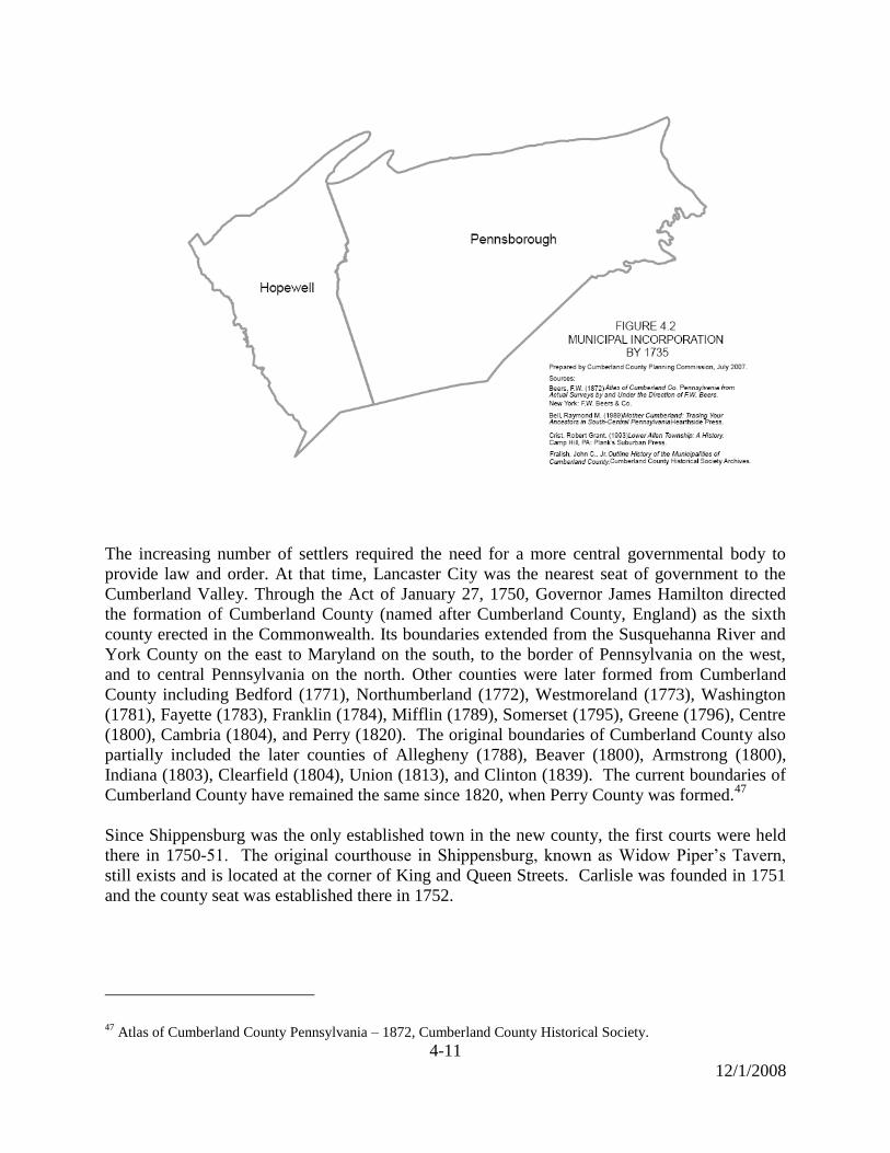
The increasing number of settlers required the need for a more central governmental body to
provide law and order. At that time, Lancaster City was the nearest seat of government to the
Cumberland Valley. Through the Act of January 27, 1750, Governor James Hamilton directed
the formation of Cumberland County (named after Cumberland County, England) as the sixth
county erected in the Commonwealth. Its boundaries extended from the Susquehanna River and
York County on the east to Maryland on the south, to the border of Pennsylvania on the west,
and to central Pennsylvania on the north. Other counties were later formed from Cumberland
County including Bedford (1771), Northumberland (1772), Westmoreland (1773), Washington
(1781), Fayette (1783), Franklin (1784), Mifflin (1789), Somerset (1795), Greene (1796), Centre
(1800), Cambria (1804), and Perry (1820). The original boundaries of Cumberland County also
partially included the later counties of Allegheny (1788), Beaver (1800), Armstrong (1800),
Indiana (1803), Clearfield (1804), Union (1813), and Clinton (1839). The current boundaries of
Cumberland County have remained the same since 1820, when Perry County was formed.47
Since Shippensburg was the only established town in the new county, the first courts were held
there in 1750-51. The original courthouse in Shippensburg, known as Widow Piper’s Tavern,
still exists and is located at the corner of King and Queen Streets. Carlisle was founded in 1751
and the county seat was established there in 1752.
47
Atlas of Cumberland County Pennsylvania – 1872, Cumberland County Historical Society.

4-12
12/1/2008
When Cumberland County was established, Middleton Township was created largely from land
that was part of West Pennsborough and partially from land that was part of East
Pennsborough.48
Shortly after the county was created, Allen Township split from the southern
portion of East Pennsborough, with the new border roughly following present-day Trindle Rd.
(Rt. 641).49
Although the date Allen Township was established is not certain, County Court
House records refer to an ―Allen Township‖ as early as 1758, so the township’s creation must
have occurred earlier in the 1750s.50
Hopewell Township included most of present-day Franklin County until the 1740s.51
In 1741,
Antrim Township split from Hopewell Township and later became part of Franklin County. The
extent of Hopewell decreased further in 1767, when Newton Township was established and
again in 1783 when Southampton Township was created.52
Southampton originally included
areas on both sides of what is now the Franklin County line.53
When Franklin County was
established in 1784 Southampton was split resulting in a Southampton Township in each county
today.
48
John C. Fralish, ―Outline History of Municipalities in Cumberland County‖ (Cumberland County Historical
Society, 1978). 49
Robert Grant Crist, Lower Allen, A History (Camp Hill, Pa: Planks Suburban Press, 1993) 5. 50
Ibid, 7. 51
Fralish, ―Outline History of Municipalities in Cumberland County‖ 52
Raymond Bell, Mother Cumberland: Tracing Your Ancestors in South-Central Pennsylvania, (Alexandria, Va:
Heartside Press, 1989) 43. 53
Fralish, ―Outline History of Municipalities in Cumberland County‖

4-13
12/1/2008
West Pennsborough also continued to encompass less territory, when Dickinson was created
from the southern region in 1785 and Frankford was created from the area north of the
Conodoguinet in 1795. Silver Spring split from the western portion of East Pennsborough in
1787. Southampton Township’s territory diminished in 1793 when Shippensburg Township was
established. In 1797 the northern area of Newton Township became Mifflin Township.54
Although Newville was laid out as a village in the 1790s, it was officially incorporated as a
borough, separate from Newton Township, in 1817.55
Middleton Township split north and south of Carlisle in 1810, when North Middleton and South
Middleton were established. Shippensburg Borough incorporated separate from Shippensburg
Township in 1819. Monroe was created from the western portion of Allen Township in 1825,
Mechanicsburg Borough officially incorporated in 1828, and New Cumberland Borough
decreased the area of Allen Township in the east in 1831. Allen Township was further divided
around 1850 when Upper and Lower Allen were created.
54
J. Zeamer, ―Records of a Century Ago Tell the Story of How Mifflin Township was Formed out of Newton,‖ The
Valley Times, Vol XXV, Nov. 1906. 55
John C. Fralish, ―Outline History of Municipalities in Cumberland County‖ (Cumberland County Historical
Society, 1978).

4-14
12/1/2008
During the 1800s, the spelling of East Pennsborough and West Pennsborough changed to East
Pennsboro and West Pennsboro. The earliest reference found for the spelling of ―Pennsboro‖ is
in the 1823 Official Tax Rates.56
In the 1843 Official Tax Rates the two municipalities are
spelled ―Pennsborough‖ and in the 1864 document both spellings are used.
East Pennsboro continued to shrink in 1845, when Hampden Township was established. North
Middleton was essentially split in half, when Middlesex was created in 1859 from its eastern
half. Dickinson was also divided in half, when Penn Township was established from the western
side of Dickinson in 1860. Later Cooke Township was created in 1872 from a substantial portion
of the southern mountainous area of Penn Township. Two boroughs were incorporated in the
middle of existing townships, when Newburg (1861) and Mt. Holly Springs (1873) were created
from Hopewell and South Middleton Townships respectively. Mifflin Township divided into
Lower and Upper Mifflin in 1892.
56
Cumberland County Historical Society
4-15
12/1/2008
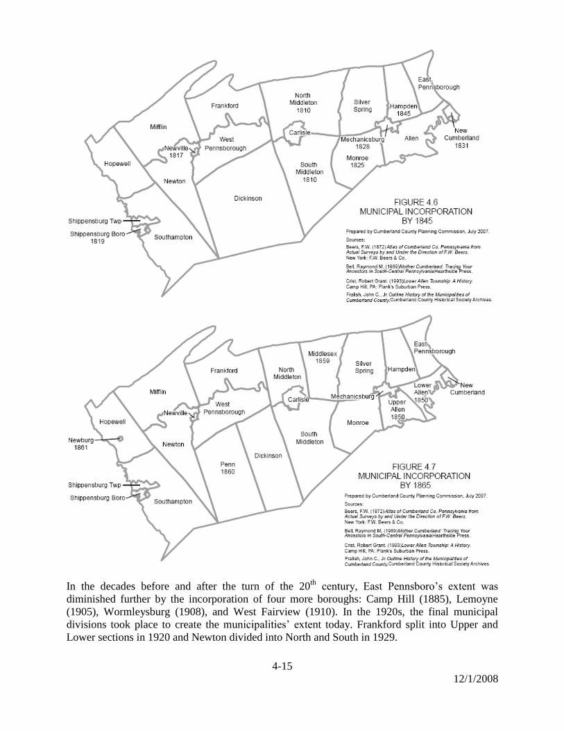
In the decades before and after the turn of the 20th
century, East Pennsboro’s extent was
diminished further by the incorporation of four more boroughs: Camp Hill (1885), Lemoyne
(1905), Wormleysburg (1908), and West Fairview (1910). In the 1920s, the final municipal
divisions took place to create the municipalities’ extent today. Frankford split into Upper and
Lower sections in 1920 and Newton divided into North and South in 1929.

4-16
12/1/2008
French & Indian War
Carlisle and Shippensburg were located on the western frontier of British controlled
Pennsylvania in the 1750s. These towns were strategically important because of their location
and as the starting point of various paths that led west into French controlled territory.
In 1755, the British General Braddock was defeated in his campaign to capture Fort Duquesne
(Pittsburgh) in western Pennsylvania. Afterward, many Delaware and Shawnee tribes that had

4-17
12/1/2008
been alienated by the British in the Treaty of 1736 supported the French.57
It was feared that the
Delaware and Shawnee, who knew the trails across Pennsylvania, might use them to take
revenge on the settlers who occupied the land where they once lived.58
As a result, the Provincial
Government authorized forts to be constructed in Carlisle and Shippensburg to guard against
raids. Fort Morris was built at Shippensburg and Fort Lowther was built at Carlisle between
1755-58. In addition, several private forts were established in the County, which were self-
sustaining and maintained by volunteers.59
These included McCormick’s Fort near Newburg,
Mitchel’s Fort at Three Square Hollow, McComb’s Blockhouse near Doubling Gap, Ferguson’s
Blockhouse near Carlisle Springs, and Fort Pleasant at Camp Hill.
A military camp was established in Carlisle in 1757 and a large supply depot was ordered to be
built there in 1758. This was the forerunner of the present day Carlisle Barracks, which is
identified as the oldest army post in the United States.60
Carlisle became the southern
headquarters for the British army during the French and Indian War. It served as a supply base
and jumping-off point for expeditions to the west. From this base in Carlisle, Colonel Armstrong
led a successful raid against the Indian town of Kittanning in 1756, General Forbes led a British
army to capture Fort Duquesne in 1758, and Colonel Bouquet led a British force to victory at
Bushy Run in 1763 during Pontiac’s War.
Early Industry
Agriculture
Cumberland County’s economic base was the agricultural industry in the 18th
and 19th
centuries.
The rich limestone soils produced a surplus of crops and supported other farm-related industries
such as milling and tanning. From its beginnings as basic subsistence through the innovations of
the industrial age, agriculture has been a vital industry in Cumberland County and a defining way
of life for many Pennsylvanians. The history of agriculture in Cumberland County can be seen
as mirroring larger trends within the Commonwealth.
By the time European settlers arrived in Cumberland County, Indian villagers were cultivating
crops of corn, beans, peas, squash and melons to supplement their dietary staples of game, fish
and woodland gatherings. Though the European settlers brought with them their own farming
methods, the native crops introduced to them by the Indians, especially corn, became staples.
The main groups of settlers, Scots-Irish and German, each brought a distinct farming history.
The Scots-Irish arrived first and cleared fields for crops. Their farming techniques though,
tended to wear out the soil over time. German farming techniques, on the other hand, maintained
the productivity of the soil. While most of the original Scots-Irish farmers in Cumberland
County continued to move west, the Germans who later acquired their farms tended to stay.61
57
Hayes R. Eschenmann, Indians, Indians (Shippensburg, Pa: Whippoorwill Publications, 1992) 44. 58
Paul A. W. Wallace, Indians in Pennsylvania (Pennsylvania Historical and Museum Commission, 1981) 148. 59
Eschenmann, Indians, Indians, 18. 60
Pennsylvania Historical & Museum Commission, Historical Markers Program, 1982. 61
Philip S. Klein and Ari Hoogenboom, A History of Pennsylvania, (University Park, Pa: Pennsylvania State
University, 1980) 191-197.

4-18
12/1/2008
Wheat and corn became the principle crops, along with flax, hemp, tobacco, barley, rye and oats.
By the 1750s, nearly all the good farm acreage in the County had been claimed and was under
cultivation.62
From the early 1700s through the 1820s, Pennsylvania’s rich soils and adaptable
farmers made it the leading producer of food in the colonies and, subsequently, the new United
States. The Commonwealth became known as both the ―granary of the Revolution‖ and
―breadbasket‖ of the nation. During this time, about 90% of the state's colonial population was
engaged in farming, which in turn resulted in the proliferation of water-powered gristmills and
the development of rural villages to provide amenities and commercial markets.63
By the Revolutionary War, soil depletion was becoming more common. To address the problem
an expanded system of crop rotation was developed by scientific experimenters and gentlemen
farmers in Philadelphia that revolutionized Pennsylvania agriculture. Soil was fertilized with
lime and gypsum, and soil-enriching crops like grass and red clover were rotated with grains, in
contrast to the traditional European rotation of grain-only crops. The larger herds of livestock
that could be sustained by grazing on the grass and clover supplied sufficient manure to aid in
fertilization, and so the process became self-perpetuating.
As sufficient acreage of cropland was cleared by the end of the eighteenth century, the
cultivation of grains and grasses for livestock consumption became more viable. The German
farmers, with well-adapted stock from a similar climate, were the first to build herds of cattle.
Pigs, heartier and more self-sufficient than cattle, were also vital, and Pennsylvania was a leader
among the colonies in the export of salt pork. Reliance on hand labor was gradually replaced by
greater use of animals to haul, plow, and operate machinery. Technological advances also
occurred, such as the development of plows made partially or fully out of cast iron. In the early
1800s the McCormick family invented the reaper, which made possible the development of
modern agricultural practices. Thomas McCormick, a member of that family, was a resident of
Cumberland County and settled in Silver Spring Township in 1745. The historic McCormick
farmhouse and farm have been preserved.
Agriculture remained the base for Cumberland County’s economy during the nineteenth century,
and farming and farm-related industries such as milling and tanning supported most of the
county’s residents. Between 1820 and 1920, Pennsylvania agriculture saw dramatic changes. A
wide variety of mechanical devices were being patented and manufactured to tackle virtually all
farming tasks. Agricultural fairs, which reached their heyday in Pennsylvania between 1850 and
1870, gave farmers the opportunity to learn and exchange new ideas on crops, techniques and
machinery. In 1857 Frederick Watts, a pioneer in agricultural reform, designed and operated a
model farm west of Carlisle. Watts, a resident of Cumberland County, was a founder of the
Farmers’ High School (now Penn State University) and first president of the Pennsylvania
Agricultural Society. Wheat grown in Cumberland County had become known for its excellent
quality, and in 1877 Queen Victoria of England ordered 50 barrels of flour made at a mill on the
Big Spring.64
The wheat for the flour was grown on a farm near Stoughstown. Subsequently,
the Queen requested a second order for 100 barrels.
62
Randall M. Miller and William Pencak, Pennsylvania, A History of the Commonwealth, (University Park, Pa:
Pennsylvania State University Press, 2002) 109. 63
Klein and Hoogenboom, A History of Pennsylvania, 191-197. 64
Georgia Peffer, ―History of Springfield‖, Newville Civic Club.

4-19
12/1/2008
A nation-wide depression occurred in the 1870s and with the completion in 1869 of the first
transcontinental railroad, Pennsylvania farmers faced new competition from western growers.
By the 1920s, agricultural employment had dropped to only twenty percent of the state’s total
work force, down from the figure of eighty percent a century before. The number of farms and
total area cultivated reached a peak in the 1880s—213,542 farms totaling 19,741,341 acres—but
these figures have been in decline ever since.
Beginning in the late 1900s, the raising of poultry, the production of fruit, and the rise of the
dairy industry lessened Pennsylvania farmers’ reliance on the more competitive staple grains of
wheat and corn. Pennsylvania remains fourth in the nation in terms of dairy production. Despite
increasing loss of land to suburban sprawl, agriculture and related enterprises remain
Pennsylvania’s largest industry. In addition to the over four billion dollars generated annually by
Commonwealth farms, an additional forty-four billion dollars of revenue is generated from the
processing and retailing of farm products. Pennsylvania is also a national leader in the attempt to
preserve farmland. Since 1989, over 344,465 acres have been secured through deed restrictions
and purchase of development rights. In Cumberland County more than 12,500 acres have been
preserved between 1989 and 2007.
Mills
Cumberland County’s rich agricultural soils resulted in a surplus of crops in many areas of the
county in the 18th
and 19th
centuries. The abundance of grain along with the proximity of several
creeks led to the importance the milling industry.65
Many mills were scattered along the
Conodoguinet Creek, the Yellow Breeches Creek, the Big Spring, and the Cedar Run. During the
19th
century, mills processed a wide range of raw materials, as evidenced by the many types of
mills throughout the county including: paper, grist, rolling, clover, plaster & chopping, oil, hemp
and woolen. There were more than 140 mills throughout the county around 1840 and often
different types of mills were co-located.66
Mills were also frequently found near the iron furnace
and forging operations throughout the county.
Limekilns
Limekilns had a presence in the county prior to 1900 due to the abundance of limestone in the
valley and the prominence of agriculture. The kilns were used to burn limestone to make
―quicklime,‖ which was used as a fertilizer and also used for painting, as an ingredient in mortar,
and even for medicinal purposes.67
Limekilns declined in use when the commercial lime
industry grew significantly around the turn of the 20th
century.68
The remains of at least two
limekilns survive in Cumberland County. One is located on Willow Mill Park Road in Silver
Spring Township and another is on Lisburn Road in South Middleton Township.
65
Nancy Van Dolsen, Cumberland County: An Architectural Survey (Ephrata, Pa: Science Press, 1990) 123-124. 66
Ibid, 124 67
David and Marlene Keefer, History of Mechanicsburg and Surrounding Area, (Mechanicsburg, Pa:
Mechanicsburg Area Historical Committee, 1976) 89. 68
Paul D. Hoch, Carlisle History & Lore, Its People, Places and Stories(Carlisle, Pa: Cumberland County Historical
Society, 2003) 93.
4-20
12/1/2008
Iron Furnaces
The iron ore industry became a major part of Cumberland County’s economy by the beginning
of the 19th
century and contributed to the growth of the areas surrounding the forges and
furnaces. Most of the iron production operations were located in the South Mountain area where
iron ore, limestone, wood to make charcoal, and water power were readily available. The larger
iron furnace or forge sites grew into self-sufficient areas of settlement that often included a
mansion house for the iron master, workers housing, their own saw or grist mills, blacksmith
shops, farmland, barns or stables.69
As early as the mid to late 18th
century, several iron furnaces
were established in Cumberland County.
Carlisle Iron Works in Boiling Springs was established in the 1760s. During this same period the
springs were dammed to provide power to operate the bellows. Later in 1784, the Yellow
Breeches Creek was dammed at Island Grove to provide power for the grist mill.70
Pine Grove
Furnace was established in present-day Cooke Township circa 1764, and by 1772 a saw mill was
constructed on adjacent lands. By the 1790s, the operation had grown and included over 1,000
acres. Cumberland Furnace was established in 1798 in the village of Huntsdale in what is now
Penn Township. Laurel Forge was established circa 1830 near Pine Grove Furnace in present-
day Cooke Township. During the first half of the 1800s, one family, the Ege family, owned Pine
Grove Furnace, Cumberland Furnace, Laurel Forge, Mt. Holly Forge and Iron Works, and
Carlisle Iron Works in Boiling Springs.71
Railroads were built to link the production activities on
South Mountain to Carlisle.
Although a concentration of iron production operations were in close proximity to the iron ore
banks at the eastern end of South Mountain, other sites did develop in the county. With iron ore
banks scattered throughout Southampton Township, 3 furnace operations were established in the
19th
century.72
In Lower Allen Township, Liberty Forge was established in 1835 one mile
downstream from the village of Lisburn. During the Civil War, this location was very busy due
to the demand for iron products.73
By the mid to late 19th
century the technology had shifted away from charcoal to anthracite coal
and steel began to overtake the market for iron products. After the Civil War, the iron industry
was revived in Boiling Springs and the village saw a period of growth in the 1870s.74
By the end
of the 19th
century the iron industry had died out in Cumberland County due to shifts in
technology.
69
Paul D. Hoch, Carlisle History & Lore, its People, Places and Stories, (Carlisle Pa: 2003) 79. 70
Richard L. Tritt and Randy Watts, At a Place Called the Boiling Springs (Boiling Springs, Pa: Boilings Springs
Sesquicentennial Publications Committee, 1995) 16. 71
Nancy Van Dolsen, Cumberland County: An Architectural Survey (Ephrata, Pa: Science Press, 1990) 90. 72
Ibid, 277. 73
Robert Grant Crist, Lower Allen, A History ( Camp Hill, Pa: Planks Suburban Press, 1993) 40. 74
Richard L. Tritt and Randy Watts, At a Place Called the Boiling Springs (Boiling Springs, Pa: Boiling Springs
Sesquicentennial Publications Committee, 1995) 24.
4-21
12/1/2008
Earthenware and Stoneware Pottery
Cumberland County contained several pottery manufacturers in the late 1700s and 1800s. The
pottery tradition was brought with the German settlers and the skill was passed down within a
family. Shippensburg was the center for producing pottery in Cumberland County from 1793 to
1890. The other substantial pottery sites in the County were Newville, Carlisle, and South
Middleton Township. Of these, Newville produced the greatest quantity of pottery. By the end
of the 1800s the production of pottery was declining as a result of new technology in food
preparation and storage. The light-weight glass canning jar and tin can became available and
eventually replaced the more bulky and fragile pottery.75
Harrisburg Nail Works
A large mill originally known as the Fairview Iron Works was built in 1845 in the Village of
West Fairview. It was located along the Conodoguinet Creek near its junction with the
Susquehanna River. The iron works manufactured iron cut nails and was later known as the
Harrisburg Nail Works. In the mid–1800s the business greatly expanded and by 1854 it included
two rolling mills, two nail factories, a cooper shop, carpenter shop, and blacksmith shop. In
1863 the Nail Works employed approximately 800 workers and was one of the largest nail mills
in the United States. After the Civil War the wire nail was invented in Germany which doomed
the future of cut nails. By the 1890s production ceased at the Nail Works in West Fairview and
the mill was torn down in 1911.76
Cloverdale Spring Company
In 1865, prospectors drilling for oil in Lower Mifflin Township struck a large, high quality
aquifer. A local doctor was so impressed with the water’s purity that he provided it to his
patients. By 1885 the water was being bottled and sold for medicinal purposes. Later, the
Cloverdale Spring Company was formed and used the water in its soft drink business. The
company’s name described the profusion of clover growing near the aquifer. Because of its great
purity, Cloverdale water was shipped to workers on the Panama Canal to reduce the instances of
typhoid fever. In 1919 a new bottling plant was built near Newville and the water was piped a
distance of three miles from the spring to the plant. In 1961 the Allegheny Pepsi Cola Bottling
Company took over the operations of the Cloverdale Spring Company.77
White Clay Mining
White clay was first extracted in the 1880s during iron mining operations on the south side of
South Mountain. Until the 1890s, white clay was a by-product of iron ore mining and not mined
or used for its own purposes. The white clay was mined in the Mountain Creek Valley near
Hunters Run and Toland on South Mountain between present-day Mt. Holly Springs and Pine
Grove Furnace State Park. At least five companies mined the clay between 1890 and 1910.78
It
75
Jeanette Lasansky, Central Pa Redware Pottery, 1780-1904, and Made in mud: Stoneware Potteries in Central Pa,
1831-1929 (Newville Historical Society,1979). 76
Dr. Harvey Bashore, The Harrisburg Nail Works, West Fairview, PA (East Pennsboro Historical Society, 1915). 77
Clinton F. Beckner, Allegheny Pepsi-Cola Bottling Company (Newville Historical Society, 1965). 78
John H. Way, Your Guide to the Geology of the Kings Gap Area(Harrisburg, Pa: Pa Geological Survey, 1986) 25.

4-22
12/1/2008
was then refined into a very fine white clay called ―kaolin‖. Match heads, wall paper, writing
paper, paint additives, linoleum, rubber goods, white enameled tile, and white brick were all
products produced from this clay.79
The Mt. Holly Brick & Clay Company manufactured
―white‖ brick from 1892 until WWI and glazed the white clay with a golden color with russet
flecks.80
White clay was mined in tunnels underground until 1942 at which point operations
switched to strip mining exclusively.81
Today, the Hempt Bros. of Camp Hill have a working
quarry in this area.
Revolutionary War
Cumberland County made significant contributions in supplies and personnel to the war effort
against England. In the early 1770s, the British Army abandoned the Carlisle Barracks and
Cumberland County due to the area being far removed from the emerging theater of operations
in the colonies. Carlisle Barracks was then occupied by the Continental Army and was locally
known as Washingtonburg. It was designated as the Quartermaster Supply Headquarters for the
Western Department and was a major supplier of ordnance material for the Continental Army.
Iron ore from South Mountain supplied the materials to manufacture cannon balls, shells,
muskets, and cannon barrels.
In 1776, the Continental Congress proposed a magazine be built at Carlisle. The main powder
magazine was completed in 1777 and still stands today. It was reputedly built by Hessian
prisoners captured at the Battle of Trenton. The building was later used as a guardhouse.
Captain William Hendricks of Lowther Manor (now Camp Hill) formed a company called the
Cumberland Rifles in 1775.82
Its members were from Cumberland County and the unit had a
reputation as being excellent marksmen. The Cumberland Rifles marched from Carlisle to
General George Washington’s camp outside Boston in 1775. There they were placed with other
units from Pennsylvania under the command of Colonel William Thompson of Carlisle. This
unit was the first battalion in the colonies authorized by Congress.83
The unit participated in
Benedict Arnold’s campaign against Quebec in December 1775. During the campaign
Hendricks was killed and Thompson was captured and later paroled. William Thompson
returned to Cumberland County and died in 1781 at age 45 on his farm in North Middleton
Township. He was buried in the Old Graveyard in Carlisle.
Major John Andre, the Adjutant General of the British Army in America, was held as a prisoner
of war in Carlisle in 1776. He was held at a tavern on the north east corner of S. Hanover Street
and Chapel Alley. Major Andre was later released in a prisoner exchange. In 1779, he
negotiated with Benedict Arnold for the treasonous handing over of West Point to the British.
Major Andre was captured a second time, found guilty of spying, and hanged.84
79
John H. Way, Your Guide to Geology of the Kings Gap Area (Harrisburg, Pa: Pa Geologic Survey,1986) 25. 80
Nancy Van Dolsen, Cumberland County, An Architectural Survey (Ephrata, Pa: Science Press, 1990) 198. 81
Edith Logan Trickey and Barbara Barnitz Lillech, ―Historical Sketches of Dickinson Township‖, 1985, 40. 82
Robert Grant Crist, Camp Hill, A History (Camp Hill, Pa, 1984) 16. 83
Pennsylvania Historical & Museum Commission, Historical Markers Program, 1986. 84
Paul D. Hoch, Carlisle History and Lore, Its People, Places and Stories (Carlisle, Pa: 2003) 98-99.

4-23
12/1/2008
William Denning was a sergeant in the Continental Army and manufactured weapons at
Washingtonburg and other forges in Cumberland County. He developed an innovative process
of manufacturing cannon from wrought iron. These cannon were lighter and fired more
consistently than cast iron cannons. Some of the cannons were put into use in the Continental
Army. One of William Denning’s cannons was captured by the British and kept as a trophy in
the Tower of London.85
William Denning died in 1830 and is buried at the Big Spring
Presbyterian Church in Newville. Colonel Denning State Park in Lower Mifflin Township is
named for him. It is not known when or who added the ―colonel‖ to Sergeant William
Denning’s name.86
Molly Pitcher was born Mary Ludwig in 1754 near Trenton, New Jersey. She was working in
Carlisle as a teenager when she married John Hays. During the war, John Hays enlisted in the
Continental Army and Mary joined her husband during a military campaign. At the Battle of
Monmouth, she was carrying a pitcher of water to cool the cannons and relieve the thirst of the
crew, when she received the nickname ―Molly Pitcher‖. When her husband was wounded during
the battle, she took his place at the cannon and continued firing the gun. After the battle she was
introduced to George Washington and staff at his tent and a parade was held in her honor. She
received a pension for the action taken at the Battle of Monmouth. She returned to Carlisle and
lived in a house at the south east corner of Bedford and North streets. Late in her life she worked
as a cleaning woman at the courthouse and army barracks.87
Molly Pitcher died in 1832 and is
buried in the Old Graveyard in Carlisle.
Whiskey Rebellion
President George Washington visited Cumberland County in October 1794 in an effort to quell
the uprising in several western Pennsylvania counties against the whiskey tax. He crossed the
Susquehanna River and traveled to Carlisle along the Great Road (US Route 11). Approximately
13,000 militiamen had assembled at Carlisle and were preparing to move west to put down the
rebellion. While in Carlisle, George Washington worshipped at the Presbyterian Church on the
square. He later stood at the corner of W. High and West streets to review the troops as they
marched west. On his return, he traveled the Simpson Ferry Road. Washington described the
eastern part of the County in his diary saying that ―the lands are exceedingly fine but not under
such civilization and improvement as one might have expected.‖88
Underground Railroad
Although the Underground Railroad is a part of the history of Cumberland County, there once
was a significant slave population in the county. In 1810, half of the slaves in Pennsylvania were
located in Cumberland County. However, by 1840, the population had decreased to only 24
85
Rev. Conway Wing, History of Cumberland County, Pennsylvania (Philadelphia, Pa: James D. Scott, 1879) 9. 86
Recreation Guide to Colonel Denning State Park (Department of Conservation and Natural Resources, 2001). 87
Hoch, Carlisle History and Lore, Its People, Places and Stories, 14. 88
Robert Grant Crist, Camp Hill, A History (Camp Hill, Pa, 1984) 17.
4-24
12/1/2008
slaves and by 1850 no slaves were recorded as living in Cumberland County. Just as the
topography of the Cumberland Valley made it a logical place for the convergence of many
Indian trails, the valley was a natural passageway for the Underground Railroad.89
Daniel Kaufman is well known in Boiling Springs for his role in the Underground Railroad.
Island Grove, by the Yellow Breeches Creek just south of Boiling Springs, and the Kaufmann
Farm were waypoints for the two main routes for the Underground Railroad that led through the
county. One of the routes started at the foot of South Mountain and led through Pine Grove
Furnace and Mt. Holly Springs to Island Grove at Boiling Springs and then to Harrisburg. The
other route went from Hagerstown, Maryland to Chambersburg and Shippensburg, then to the
furnace at Huntsdale, Penn Township and down the Walnut Bottom Rd. to Daniel Kaufman’s
farm before continuing on to Harrisburg.90
In the thirteen years that Daniel Kaufman was a
leader in the Underground Railroad, he purportedly helped 60 slaves to freedom.91
His
participation ended after he was sued by the Maryland owner of 13 slaves that were hidden in
Kaufman’s barn in November of 1847 and in 1849 the suit was decided against him by a U.S.
court and he was fined significantly.92
Civil War
When the war began in 1861, the supply center at Carlisle Barracks was reactivated and the post
was also used as a recruitment center. Cumberland County was not directly impacted by the war
until 1863. In that year the Confederate army mounted an invasion of the north and the capture
of Harrisburg, Pennsylvania was one of the objectives. The Confederate commander, General
Robert E. Lee chose the Cumberland Valley as his invasion route to Harrisburg. Cumberland
County became strategically important because of its location in the Cumberland Valley and its
close proximity to Harrisburg. The Confederate army was to advance on a line from
Hagerstown, Chambersburg, Shippensburg, and Carlisle. General Lee’s orders to Lieutenant
General Richard Ewell, commanding the lead units of the invasion were, ―If Harrisburg comes
within your means, capture it.‖93
The Confederate army entered Cumberland County at Shippensburg on June 24th
, 1863.
Opposing them were two National Guard regiments from New York under Brigadier General
Joseph Knipe. His orders were to delay the Confederate advance and withdraw slowly toward
Harrisburg.94
As the Confederates occupied Shippensburg, General Knipe withdrew the New
York regiments up the Harrisburg Pike toward Carlisle. In Shippensburg, the Confederate
soldiers camped near Dykeman’s Spring.
On June 27 the Confederates left Shippensburg and advanced toward Carlisle along the
Harrisburg Pike and Walnut Bottom Road. Confederate cavalry collected supplies in the
89
Richard L. Tritt and Randy Watts, At a Place Called the Boiling Springs (Boiling Springs, Pa: Boiling Springs
Sesquicentennial Publications Committee, 1995) 111. 90
Ibid, 112. 91
Ibid, 111. 92
Ibid, 116. 93
Edward J. Stackpole, They Met at Gettysburg (Harrisburg, Pa: Stackpole Books, 1956) 13. 94
Robert Grant Crist, Confederate Invasion of the West Shore (Lemoyne, Pa: Lemoyne Trust Company, 1963) 28.
4-25
12/1/2008
countryside and a detachment entered Newville and camped just east of town, on the grounds of
Linnwood Academy.95
General Ewell’s plan was to concentrate his Confederate corps at
Carlisle and then advance on Harrisburg.96
The two New York regiments that had withdrawn
from Shippensburg erected defenses about two miles west of Carlisle along the Harrisburg Pike
and Walnut Bottom Road.97
Upon hearing that the Confederates were advancing with an
overwhelming force, General Knipe withdrew through Carlisle to New Kingstown. The
Confederates entered Carlisle late in the afternoon on June 27th
and camped on the grounds of
Dickinson College and Carlisle Barracks. The Confederate occupation of Carlisle was generally
peaceful. They took exceptional care of the campus of Dickinson College since some of the
soldiers and their fathers were graduates.98
On June 28, Confederate cavalry under Brigadier General Albert Jenkins moved forward from
Carlisle to gather supplies and scout the defenses of Harrisburg. A portion of General Jenkins
cavalry advanced northeast along Spring Road (Pa Route 34) towards Sterretts Gap. After
passing Carlisle Springs, the Confederate cavalry returned to Carlisle after hearing that the gap
was occupied by Union soldiers. A stone marker located one mile north of Carlisle Springs
identifies the northern-most advance of a Confederate army during the war.
General Jenkins cavalry also advanced east along Trindle Road and occupied Mechanicsburg in
the morning of June 28th
.99
Jenkins established his headquarters at the John Rupp house located
at 5115 East Trindle Road. In the afternoon, the Confederate cavalry advanced toward
Harrisburg in two sections. The first section advanced north from Mechanicsburg to the Carlisle
Pike and then turned east. Confederate artillery was positioned at Salem Church on the Pike and
engaged Union artillery located on Sporting Hill.100
Here, the Confederates ran into General
Knipe’s two New York regiments again. The Union troops eventually withdrew east to Oyster’s
Point, where the Carlisle Pike and Trindle Road converge. The second section of confederate
cavalry advanced along the Trindle Road and established an artillery position on the high ground
near the Peace Church. From that position the Confederates fired cannons toward Oyster’s Point
and Shiremanstown until dusk.101
Major General Darius Couch, the Union commander of the Department of the Susquehanna,
decided to defend Harrisburg from the West Shore. Fort Washington was constructed in
Lemoyne on the heights overlooking the Camelback and railroad bridges leading into
Harrisburg. The location of the fort was in the vicinity of present day Cumberland Drive. Fort
Couch was a second smaller fort constructed just west of Fort Washington on the same high
ground. The remains of Fort Couch are still visible between Indiana and Ohio avenues in
Lemoyne. Further to the west a forward skirmish line was established near Oyster’s point.
95
Civil War Tour of Newville Pennsylvania, (Newville Historical Society, 1999). 96
Edwin B. Coddington, The Gettysburg Campaign (New York: Macmillan Publishing Company, 1968) 165. 97
―Rebel Occupancy of Carlisle Bombardment of the Town Incidents,‖ Carlisle American, July 15, 1863.
(Reprinted in The Sentinel June 24, 2001). 98
Coddington, The Gettysburg Campaign, 171. 99
Robert Grant Crist, Confederate Invasion of the West Shore (Lemoyne, Pa: Lemoyne Trust Company, 1964) 30. 100
Ibid, 31. 101
Ibid, 32.
4-26
12/1/2008
On June 29, Confederate cavalry attacked the Union defenders near Oyster’s Point as a diversion
while General Jenkins made a personal reconnaissance of the Harrisburg defenses from the hills
above New Cumberland.102
General Jenkins reported to General Ewell in Carlisle that the capital
appeared to be poorly defended. Based on this report, Ewell prepared to capture Harrisburg on
June 30th
. Before that could happen, General Ewell received orders from General Lee to move
his forces south to rejoin the rest of the army. General Ewell’s troops marched out of
Cumberland County on June 30th
by two routes. The first was back the Harrisburg Pike through
Shippensburg and the second through the Mt. Holly Springs Gap (Pa Routes 34 and 94).103
While General Jenkins was withdrawing his cavalry on June 30th
, Union units moved forward
from Oyster’s Point and contacted the confederate cavalry at Sporting Hill. The resulting ―Battle
of Sporting Hill‖ is identified as the northern most engagement during the Gettysburg
Campaign.104
Confederate losses were estimated to be 16 dead and 20-30 wounded. Union losses
were approximately 20 wounded. That night Jenkins’ cavalry withdrew from Cumberland
County to the south.
On the morning of July 1, Union Troops under General William ―Baldy‖ Smith advanced from
Fort Washington and reoccupied Carlisle at about 7:00 p.m. Also on July 1, Confederate cavalry
commanded by General Fitzhugh Lee approached Carlisle from the southeast. The unit was part
of Major General J.E.B. Stuarts’ cavalry and was unaware that the Confederate forces had been
recalled from the area to unite further south. The Confederates formed near the juncture of
Trindle and York roads. General Fitzhugh Lee sent a messenger into town with a flag of truce
demanding that the town surrender or he would shell it. General Smith refused, telling the
messenger, ―Shell and be damned.‖105
The shelling of Carlisle soon commenced and several buildings in the downtown were damaged.
The Old County Courthouse on the square was struck by shells during the bombardment and the
damage is still visible in a pillar and right front windowsill. At approximately 10:00 p.m. the
Confederates set fire to the Carlisle Barracks while the artillery bombardment went on until 3:00
a.m., July 2. At that time, orders were received from General Robert E. Lee to rejoin the rest of
the army near Gettysburg. General Fitzhugh Lee withdrew his cavalry from Cumberland County
in the early morning of July 2. He left by way of the Boiling Springs Road and through the Mt.
Holly Springs Gap. The shelling of Carlisle and burning of the Barracks resulted in a small
number of wounded on both sides, but no civilians were injured.106
Trains & Trolleys
The Cumberland Valley Railroad (CVRR) was chartered in 1835 by the General Assembly to
provide service from Harrisburg to Chambersburg via Carlisle and Shippensburg. Then in 1836,
the state legislature approved the Susquehanna Bridge to be built, which would allow the CVRR
to connect to the Harrisburg & Lancaster Railroad and the PA canal. Work began on both the
102
Robert Grant Crist, Confederate Invasion of the West Shore (Lemoyne Pa: Lemoyne Trust Co: 1964) 34. 103
Edwin B. Coddington, The Gettysburg Campaign (New York: Macmillan Publishing Company, 1968) 190. 104
Pennsylvania Historical & Museum Commission, Historical Marker Program, 1997. 105
Pa Civil War Trails Prelude to Gettysburg Brochure (Pennsylvania Historical & Museum Commission). 106
―Rebel Occupancy of Carlisle Bombardment of the Town Incidents‖, Carlisle American, July 15, 1863.
4-27
12/1/2008
rail line and the bridge, but due to a national financial panic in 1837, work stopped on the bridge.
Funds were shifted to continue construction of the rail line.107
The Cumberland Valley Railroad
began service in 1837 with an initial trip from the West Shore to Carlisle.108
Later in 1837, the
tracks were completed through the center of the Cumberland Valley to Chambersburg.109
It was not until 1839 that a direct connection with Harrisburg was made with a timber bridge
spanning the Susquehanna River.110
Timber construction was not the most durable for the heavy
train traffic nor was it the most fire retardant material, and the Susquehanna Bridge would be
rebuilt four times over the history of the railroad. The Susquehanna Bridge burned in 1844 and
only the 4 easternmost spans survived.111
Recognizing the value of this connection between the east and west shores for commerce, the
legislature gave the CVRR a grant to rebuild the bridge. It was completed in a similar timber
truss design in 1846.112
With the increasing weight of engines as technology progressed, the
1846 bridge was reinforced by supporting arches in 1850. Despite reinforcement and a myriad of
other modifications, the bridge was again replaced for the second time in 1856 with another
timber truss structure.113
The Susquehanna Bridge was eventually replaced a third time with new
piers constructed in 1881-1886 and with an iron structure completed in 1887. The fourth
replacement was part of another wave of updating.114
It is a heavy concrete arched bridge that
currently stands and was completed in 1916.115
While the Susquehanna Bridge provided a connection to Harrisburg and the transportation
infrastructure on the east shore, the Franklin Railroad was intended to connect the CVRR to the
Potomac via Chambersburg and Hagerstown. In 1837, the Maryland Assembly authorized the
Franklin Railroad to build from the Pennsylvania border to connect with the Baltimore & Ohio
Railroad and the Chesapeake & Ohio canal.116
By 1841, the Franklin Railroad was operating.
The Franklin Railroad had financial difficulty in the 1840s and 1850s and by the end of the Civil
War merged with the CVRR.117
York and Cumberland Railroad was completed in 1850 linking
Bridgeport (Lemoyne) to York and ultimately Baltimore.118
The demand for iron ore during and after the Civil War revived the industry in the South
Mountain area. Branch railroad lines were built to connect the forges and furnaces with the
main line railroads. Two of primary importance, built in the late 1860s and early 1870s and
serving South Mountain, were the Dillsburg and Mechanicsburg Railroad Company and the
107
Paul J. Westhaeffer, History of the Cumberland Valley Railroad (Washington DC: National Railway History
Society, 1979) 19. 108
Robert Grant Crist, Lower .Allen, A History (Camp Hill, Pa: Planks Suburban Press, 1993) 101. 109
Westhaeffer, History of the Cumberland Valley Railroad, 15. 110
Robert Grant Crist, Camp Hill, A History (Camp Hill, Pa, 1984) 27. 111
Westhaeffer, History of the Cumberland Valley Railroad, 33-34. 112
Ibid, 35. 113
Ibid, 51-53. 114
Paul J. Westhaeffer, History of the Cumberland Valley Railroad (Washington DC: National Railway History
Society, 1979) 253. 115
Donehoo, History of the Cumberland Valley in Pa, 226. 116
Westhaeffer, History of the Cumberland Valley Railroad, 43. 117
Ibid, 45, 61. 118
Ibid, 50.
4-28
12/1/2008
South Mountain Iron Company serving Pine Grove Furnace. Although both companies were
separate from the main line railroads, the CVRR did have significant financial interest invested
in their operations.119
In 1873, the Dillsburg and Mechanicsburg Railroad was leased to the CVRR and passenger
service began that same year. Later, the Dillsburg and Mechanicsburg Railroad was electrified
and in 1906 trolley service was established in addition to the freight service. The South Mountain
line remained primarily for freight traffic; however, very limited passenger service was also
provided. Both lines were bought by the CVRR as the iron industry began to decline.120
The Harrisburg and Potomac Railroad Company began construction on a rail line across the
southern side of the Cumberland Valley in 1871. The new railroad, proposed by the Ahl family
of Newville, would serve the iron ore mines on South Mountain and compete with the CVRR.
Construction progressed slowly and the line was not completed to Shippensburg until 1884.
Two railroad lines now paralleled through most of Cumberland County. The Harrisburg and
Potomac Railroad extended from Bowmansdale to Shippensburg and the CVRR from Harrisburg
through Carlisle to Shippensburg.121
The Harrisburg and Potomac line was ultimately purchased
by the Reading Railroad.122
The Northern Central Railroad was established in 1854 and the lines ran along the western side
of the Susquehanna River in Cumberland County. Around 1888, the Northern Central Railroad
added a passenger station and freight siding, called Enola, at the mid point between Fairview and
Marysville. The Northern Central Railroad began to expand the freight operations at Enola in
1903. The development of railroad facilities in Enola created hundreds of jobs in the area. With
the building of Enola Yard around 1905, the village of Enola emerged, and in 30 years had a
population of approximately 3,800 people. The expansion of the railroad also led to the
considerable growth of the neighboring communities of Summerdale, Wormleysburg, and West
Fairview. What began as a 12 track yard known as Fairview, grew into 200 miles of track over 7
miles now known as Enola Yard.123
The Cumberland Valley Electric Passenger Railway Company began with trolley service in
Carlisle around 1895. The trolley originally ran on Hanover and High Streets, but a line was
extended to the Indian School and another line to Cave Hill on the edges of Carlisle. By 1896, a
line ran to Boiling Springs, in 1901 another line extended to Mt. Holly Springs, and in 1910 a
line ran to Newville.124
The Harrisburg and Mechanicsburg Electric Railway Company was
established in the early 1890s with the intension to provide trolley service from Harrisburg,
through Camp Hill and Mechanicsburg, to Carlisle.125
By 1901, the trolley went to Camp Hill
and by 1902 to Shiremanstown and Mechanicsburg. The trolley line continued to Carlisle in
119
Paul Westhaeffer, History of the Cumberland Valley Railroad (Washington DC: Nat Railway Hist Soc, 1979) 95. 120
Ibid, 106, 111. 121
Ibid, 233. 122
Ibid, 112. 123
Nancy Van Dolsen, Cumberland County An Architectural Survey (Ephrata, Pa: Science Press, 1990) 106. 124
Paul D. Hoch, Carlisle History and Lore, Its People, Places and Stories (Carlisle, Pa: Cumberland County
Historical Society, 2003) 84-85. 125
Robert Grant Crist, Camp Hill, A History (Camp Hill, Pa, 1984) 93.
4-29
12/1/2008
1904. The CVRR viewed the emergence of trolley systems as a threat and ultimately bought
controlling interest in them in the beginning of the 20th
century to limit their expansion.126
Train and trolley companies were a significant source of employment in the county, provided a
commuting service to employment centers, and also served a recreation function. Many
recreational destinations were developed to increase use of train and trolley lines. The CVRR
offered excursion rates during the summer in the 1870s and developed parks at Pine Grove and
Williams Grove. In June of 1878, a park was established a half mile south of Pine Grove
Furnace.127
The site at Williams Grove was unique because it was originally established as the
site for the annual Grange Picnic. It was situated along the Dillsburg and Mechanicsburg line on
a 20 acre island in the Yellow Breeches Creek. The CVRR invested in the site by building a
station, two amphitheaters, a National Grange Hall, a two-story hotel and long sidings for
unloading farm machinery, livestock and produce.128
Parks were also built as destinations at the end of the trolley line just outside Carlisle at Cave
Hill and one adjacent to Cemetery Hill in Newville. Near Mt. Holly Springs, a park was created
by the lake just outside town.129
Similarly, a park, picnic grounds, and a pleasure resort were
developed by the trolley company in Boiling Springs. It became one of the most popular summer
resorts in the county.130
The trolley service began to dwindle in the early 20th
century with the
increased use of the automobile, and the parks eventually closed.
The rise in use of automobiles and trucks by the 1930s replaced the role of the trolleys and
railroads for passenger and freight service. However, railroads began declining many years
earlier, as the 1915 annual report of the CVRR noted that passenger traffic had dropped off due
to the use of private autos.131
The CVRR merged with the Pennsylvania Railroad in 1919.132
126
Paul J. Westhaeffer, History of the Cumberland Valley Railroad, (Washington DC: National Railway Historic
Society, 1979) 287. 127
Ibid, 211. 128
Ibid, 214. 129
Hoch, Carlisle History and Lore, Its People, Places and Stories, 85. 130
Richard L. Tritt and Randy Watts, At a Place Called the Boiling Springs (Boiling Springs, Pa: Boilings Springs
Sesquicentennial Publications Committee, 1995) 30. 131
Paul J. Westhaeffer, History of the Cumberland Valley Railroad (Washington DC: National Railway Historical
Society, 1979) 287. 132
Ibid, 290.
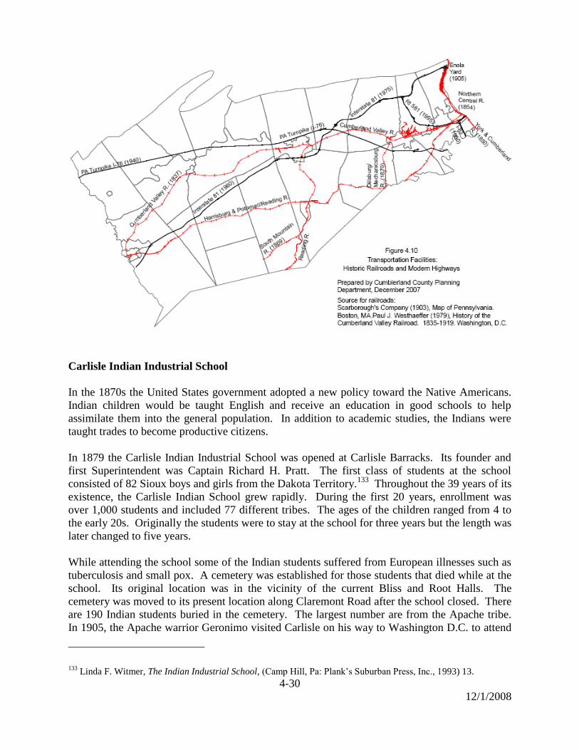
4-30
12/1/2008
Carlisle Indian Industrial School
In the 1870s the United States government adopted a new policy toward the Native Americans.
Indian children would be taught English and receive an education in good schools to help
assimilate them into the general population. In addition to academic studies, the Indians were
taught trades to become productive citizens.
In 1879 the Carlisle Indian Industrial School was opened at Carlisle Barracks. Its founder and
first Superintendent was Captain Richard H. Pratt. The first class of students at the school
consisted of 82 Sioux boys and girls from the Dakota Territory.133
Throughout the 39 years of its
existence, the Carlisle Indian School grew rapidly. During the first 20 years, enrollment was
over 1,000 students and included 77 different tribes. The ages of the children ranged from 4 to
the early 20s. Originally the students were to stay at the school for three years but the length was
later changed to five years.
While attending the school some of the Indian students suffered from European illnesses such as
tuberculosis and small pox. A cemetery was established for those students that died while at the
school. Its original location was in the vicinity of the current Bliss and Root Halls. The
cemetery was moved to its present location along Claremont Road after the school closed. There
are 190 Indian students buried in the cemetery. The largest number are from the Apache tribe.
In 1905, the Apache warrior Geronimo visited Carlisle on his way to Washington D.C. to attend
133
Linda F. Witmer, The Indian Industrial School, (Camp Hill, Pa: Plank’s Suburban Press, Inc., 1993) 13.

4-31
12/1/2008
the inauguration of President Roosevelt. While in Carlisle Geronimo visited the Indian School
and addressed the students, encouraging them to continue their studies.
Sports were very popular and the school competed against other colleges in football, baseball,
track, lacrosse, and basketball. Glen ―Pop‖ Warner was hired as the coach of the football team
in 1899. He is considered one of the most influential coaches in early football and brought
national fame to the Carlisle Indian Industrial School. At Carlisle he made football history by
introducing the ―hidden ball trick‖ and the ―wing-back‖ formation.134
One of the most famous students of the school was Jim Thorpe, who was perhaps the greatest all-
around athlete the United States ever produced.135
He was a Sac and Fox tribe Indian who was
born in the Oklahoma territory. He enrolled at the Carlisle Indian Industrial School in 1904 but
withdrew shortly afterward because of the death of his father. After a few years he returned to
the school and began his athletic career in 1907. Jim Thorpe was coached by ―Pop‖ Warner and
excelled in all school sports. He represented the United States at the 1912 Olympics and was a
multiple gold medal winner. In 1913 the medals were revoked by the International Olympic
Committee when it was discovered that Jim Thorpe had previously played two seasons of minor
league baseball. The medals were eventually restored to his family in 1983. Jim Thorpe was
named the greatest athlete of the 1st half of the 20
th Century by the Associated Press in 1950.
136
Jim Thorpe returned to Carlisle in 1951 for the premier of a movie about his life. He died in
1953 at his home in California.
By the beginning of the 20th
Century government policies toward Native Americans began to
change. Many questioned the necessity of removing Indian children from their home
environment. Non-reservation Indian schools, modeled after the Carlisle school, began to be
developed in the west and it seemed more practical to enroll the children there. Also, the
American war effort in World War I and caring for the wounded took precedence over the school
program. The Carlisle Indian Industrial School closed in 1918 and its buildings were used as
Base Hospital Number 31.137
Educational Institutions
Almost since its creation, Cumberland County has been a national leader in providing advanced
educational facilities. The County is the home of some of the first types of colleges and schools
chartered in the state and the country.
Dickinson College
Benjamin Rush, a physician from Philadelphia, prepared the charter for Dickinson College in
1783. Rush received permission to name the college after John Dickinson, who at the time of the
charter was Governor of Pennsylvania. The college replaced a struggling grammar school in
Carlisle. Less than a week before the charter, the Treaty of Paris officially ended the American
134
Linda F. Witmer, The Indian Industrial School, (Camp Hill, Pa: Plank’s Suburban Press, Inc, 1993)48. 135
Ibid, 82. 136
―Jim Thorpe,‖ 29 Jan. 2008 <http://Wikipedia.org>. 137
Linda F. Witmer, The Indian Industrial School, (Camp Hill, Pa: Plank’s Suburban Press, Inc., 1993) 90.
4-32
12/1/2008
Revolution and guaranteed international recognition of the United States. Dickinson College
became the first college chartered in the new United States of America.138
Dickinson School of Law
Dickinson School of Law was founded by John Reed in 1834. The law school is the oldest in
Pennsylvania and the fifth oldest law school in the United States. The school was independently
operated for over 150 years until it merged with Pennsylvania State University in 2000.139
Irving Female College
A wealthy man by the name of Solomon P. Gorgas founded Irving Female College in 1856. The
college was located in Mechanicsburg and named after Washington Irving. Washington Irving
served on the Board of Trustees until his death in 1859.
Solomon Gorgas believed that young women were entitled to an education beyond public
schools. Irving College was the fifth all female college in America, and the first in Pennsylvania
to grant degrees in arts and sciences. In 1929 Irving College closed after graduating 874 women
in seventy-two years.140
Shippensburg University
In 1850 the Cumberland County school directors held a convention to plan for a normal school.
However, due to poor attendance at the convention the original normal school was never opened.
On December 23, 1856 in Newville a resolution was passed to reconsider establishing a normal
school in Cumberland County. A few weeks later on January 13, 1857 a committee met in
Carlisle to determine that the placement of the proposed normal school should be located in
Newville141
. The Civil War created major hardships for educational centers, and the school in
Newville was closed in 1861142
.
Shippensburg University was established in 1871 as the Cumberland Valley State Normal
School. On February 21, 1873 State Superintendent Wickersham visited the Cumberland Valley
State Normal School and officially approved the institution for the state. The first class of 217
students was admitted on April 15, 1873.143
The school experienced a variety of changes throughout the twentieth century. On June 4, 1926,
the school was authorized to grant Bachelors of Science degrees for education in elementary and
junior high education. It became the first normal school in Pennsylvania to become a state
teachers college on October 12, 1926. The following year the State Council of Education
authorized the school to change its name to the State Teachers College at Shippensburg. On
138
―The Dickinson Story,‖ 29 Jan. 2008, <http://www.dickinson.edu>. 139
―Dickinson School of Law,‖ 29 Jan. 2008, <http://en.wikipedia.org>. 140
Lisa Graybeal, ―A final reunion but not goodbye,‖ Patriot News, 9-14-1999. 141
John Hubley, Fountainhead of Teachers: a History of the First Ninety Years of Shippensburg State College,
(Shippensburg, Pa: News-Chronicle Publishing Company, 1964) 4. 142
Ibid 5. 143
Ibid 17.
4-33
12/1/2008
December 8, 1939 the Middle States Association of Colleges and (Secondary) Schools
accredited Shippensburg State Teachers College. This made the college the first in Pennsylvania
and fourth in the United States to be accredited by the Middle States Association of Colleges and
(Secondary) Schools.144
Shippensburg State Teachers College continued to grow at a rapid pace. The State Council of
Education on January 7, 1959 authorized the Master of Education degree. The following year on
January 8, 1960 the college would be renamed to Shippensburg State College. During the 1960s,
the State Council of Education would authorize the arts and sciences curriculum, and the
Bachelor of Science in business administration.
When the Governor of Pennsylvania signed Bill 506 on November 12, 1982, it established the
State System of Higher Education. After the bill was signed, Shippensburg State College was
designated as Shippensburg University of Pennsylvania on July 1, 1983. Two years later in
1985, many of the historic buildings, including Old Main, were listed on the National Register of
Historic Places.145
US Army War College
The need for advanced officer training became evident during the Spanish-American War.
Officers in higher positions were unprepared to handle the problems of sudden mobilization,
training, and widespread deployment.146
In 1899, Elihu Root, Secretary of War under President
McKinley, recommended the establishment of an institution to prepare selected officers for
command at the highest levels of the army. Elihu Root indicated the purpose of the institution
would be, ―Not to promote war, but to preserve peace by intelligent and adequate preparation to
repel aggression.‖
In 1901 The Army War College was founded and in 1904 it opened in Washington D.C. Its first
class contained nine officers, including Captain John J. Pershing. After World War II the Army
deactivated the War College in 1946. The College was temporarily reopened in 1950 at Fort
Leavenworth, Kansas. In 1951, the Army War College moved to Carlisle Barracks. It was
officially designated the ―U.S. Army War College‖ in 1957.
The U.S. Army War College currently has a resident program which consists of a 10-month
course of study and a distance education program taught over 2 years. The average student at
the College has a rank of lieutenant colonel and 19 years of service.147
Messiah College
Messiah College was founded in 1909 in Harrisburg, Pennsylvania by the Brethren in Christ
Church. In 1911, the school relocated to Cumberland County near the village of Grantham. The
144
John Hubley, Fountainhead of Teachers: A History of the First Ninety Years of Shippensburg State College,
(Shippensburg Pa: News Chronicle Publishing Co, 1964) 64. 145
―Shippensburg University of Pennsylvania,‖ 29 Jan. 2008, <http://en.wikipedia.org>. 146
US Army War College, A Brief Narrative, Information for Guests, 1. 147
Ibid, 9.
4-34
12/1/2008
college was originally called Messiah Bible School and Missionary Training Home.148
Roger
Smith is considered by many as the original founder of the college and was the secretary of the
General Conference until his death in 1916. In June of 1907 the Incorporation Board met in
Buffalo, New York and requested that Smith choose the departments of study for the college.
Smith decided that a preparatory department, general Bible courses, advanced teachers course,
and a missionary department were essential to the school. Smith also chose more secular courses
such as math, grammar, language, history, vocal music, and science. Some congregation leaders
opposed these courses because they felt these topics should be taught to the students before
enrolling at the school.
Messiah College is the Brethren in Christ denomination’s first school, and experienced some
changes in the early years of existence.149
Ten years later it became a junior college and changed
its name to Messiah Bible School. Later in the 1950s the school changed its name to Messiah
College, and began to offer four year college programs. By 1959 the high school program was
discontinued and a liberal arts program was added.150
Central Pennsylvania College
The Central Pennsylvania College was founded in 1881 by Joseph N. Curry and was originally
located at 307 Market Street in Harrisburg. Professor William H. Hartsock left his position at the
college as head of the accountancy department and opened Central Pennsylvania Business
College a few blocks away on October 22, 1922. In 1970, Bart and Jean Milano moved the
college to Summerdale, which is located in East Pennsboro Township.
Central Pennsylvania Business College changed its name to Central Pennsylvania College in
1977 when the Commission on Higher Education of the Middle States Association of Colleges
and Schools accredited the school. The Commonwealth of Pennsylvania granted Central
Pennsylvania College as a two-year college in 1999. The following year Pennsylvania’s
Secretary of Education approved Central Pennsylvania College to grant four-year degrees.151
Architecture
Architecture in Cumberland County was influenced by the building traditions of the early
European settlers to the region – the Scots-Irish and Germans. Also, the interaction between
these two groups encouraged new construction technologies and forms.152
Cumberland County was primarily settled by the Scots-Irish in the early to mid 18th
century. The
traditional Scots-Irish house was a one-story stone building usually consisting of two rooms.
Since wood was the dominant construction material in Cumberland County, the Scots-Irish used
logs to build their traditional style homes. Few of these early log buildings survive today. One
existing example of this type of architecture is the Rose Garden Mill, located along the Yellow
148
E. Morris Sider, Messiah College: A History, (Nappanee, In: Evengel Press, 1984) 1. 149
Ibid, 15. 150
―Messiah College,‖ 29 Jan. 2008, <http://en.wikipedia.org>. 151
―History of Central Penn,‖ 29 Jan. 2008, <www.centralpenn.edu>. 152 Nancy Van Dolson, Cumberland County: An Architectural Survey (Ephrata, Pa: Science Press, 1990) 1.

4-35
12/1/2008
Breeches Creek near U.S. Route 15 in Upper Allen Township. The structure was built around
1747 and is one of the oldest buildings in the County.153
The County does contain some 18th
Century stone buildings that were originally constructed in the Scots-Irish tradition, but they
were later redesigned to reflect a more Georgian style.
Large numbers of German settlers began to arrive in Cumberland County in the late 18th
and
early 19th
century. The traditional German house was different in appearance that the Scots-Irish
house. The German house was usually 2 stories, square shaped, and contained up to four rooms.
An example of this type of architecture is the John Stayman House in Hampden Township,
which was built around 1790.154
In the beginning of the 19th
century the housing of both groups began to show an increasing
influence of the Georgian form. The Georgian Plan is a 2 story, 5 bay stone dwelling with a
center hallway. The basic Georgian form is considered an English style but it was used in central
Europe and was familiar to the German settlers. During the first quarter of the 19th
Century the
County’s architecture was changing from the interaction of the Scots-Irish, Germans, and the
acceptance of the Georgian style.155
The Georgian form became increasingly popular and this architectural style was used throughout
the County for most of the 19th
century.156
Examples of this architecture are the William
Harkness House (built prior to 1798) in Upper Allen Township and the James Given House, also
known as the Two Mile House (ca. 1820) in South Middleton Township. During this time period
other influences were combined with the Georgian such as Federal, Gothic Revival, and Greek
Revival.
Variations to the basic Georgian form occurred throughout the 19th
century. The Two–thirds
Georgian House Type was a common house plan at this time. It resembled a full Georgian plan
except the rooms on one side of the entrance hallway were removed, which shifted the entrance
from the center to the left or right front of the building. This house type was very popular in
towns and villages because it was able to fit into narrow town lots. The Widow Piper’s Tavern
on King Street in Shippensburg is an example of a Two–thirds Georgian House Type.157
Another variation to the Georgian form was Georgian–Germanic or Pennsylvania Farmhouse
Type. These dwellings date from the mid 19th
century and are known locally as double front
door houses. These houses have 2 stories, a four-bay front and two central doors. The Samuel
Peffer House in South Middleton Township is an example of the Georgian–Germanic
structure.158
The County’s barns were another type of architecture that dominated the rural landscape.
Agriculture was the major economy in Cumberland County in the 18th
and 19th
centuries. The
mid 19th
century was a time of increased productivity due to mechanization, more scientific
farming practices, and an excellent market for agricultural goods. Farming prospered and it was
153
Nancy Van Dolson, Cumberland County: An Architectural Survey (Ephrata, Pa: Science Press, 1990) 5. 154
Ibid, 13. 155
Ibid, 24. 156
Ibid, 18. 157
Ibid, 22. 158 Ibid, 37.
4-36
12/1/2008
reflected in the amount and type of barns that were built. The common barn type was a
Pennsylvania bank barn, many of which were stone bank barns utilizing the native limestone
from the region. In 1840, 292 stone barns stood in Cumberland County and it was noted that the
entire eastern Cumberland Valley was a ―virtual continuum of stone barns.‖159
Another type of
barn that is unique to the area is the brick-end barn. These barns have ventilation openings on
the sides in the form of patterns, which are created by omitting bricks as the barn is constructed.
Most of these barns were built in the middle of 19th
century and can be found in southeastern and
south central Pennsylvania and northern Maryland. In Pennsylvania, most are concentrated in
Cumberland, Adams, York, and Franklin counties.
During the end of the 19th
Century and early decades of the 20th
Century the County experienced
suburban growth on the fringes of established boroughs and within the adjoining townships.
These new neighborhoods were initially developed as ―streetcar suburbs‖, allowing development
to occur along public transit corridors. From the end of World War I until 1945, the increase in
automobile ownership brought an end to streetcar use and greatly expanded the amount land
available for residential development. 160
Suburban growth occurred mainly in the eastern portion of Cumberland County where
population density was higher and community facilities such as public sewer and water were
available. Tree lined streets and landscaped public areas were important components of early
suburban developments.161
Examples of early suburban communities include Highland Park in
Lower Allen Township and Old Mooreland in Carlisle Borough.
New dwelling styles were introduced into these suburban neighborhoods. Two common types of
housing built were the four square and the bungalow.162
The term ―four square‖ refers to the
building’s cubic shape, which had a pyramidal roof. The roof usually includes four dormers –
one on each slope of the roof. The bungalow is a one-and-a-half story house with a shallow
pitched roof. One of the most popular styles in the County at this time was the Colonial Revival
style.163
It began with the country’s centennial in 1876 and remained popular into the 20th
Century. The style includes elements from the Georgian, Federal, and Greek Revival forms and
uses them on a variety of building types – from bungalows to mansions. An example of the
Colonial Revival style is the Lewis S. Sadler mansion (known as Thornwald) located in
Carlisle.164
State and Federal Recreation Areas
Cumberland County contains several historically significant parks. Each preserves a unique
period in the County’s history and provides social and recreational opportunities for residents.
Pine Grove State Park
159
Nancy Van Dolson, Cumberland County: An Architectural Survey (Ephrata, Pa: Science Press, 1990) 310. 160
National Park Service,National Register Bulletin,―Historic Residential Suburbs‖, 25 Sept 2008,<http://www.nps.> 161
Pennsylvania Historical and Museum Commission, ―Historical Landscapes‖, 25 Sept 2008, <http://www.phmc>. 162
Van Dolson, Cumberland County: An Architectural Survey, 53. 163
Ibid, 58. 164
Ibid, 59.
4-37
12/1/2008
The park land was purchased by the Commonwealth in 1913 and includes 696 acres. The first
Civilian Conservation Corps (CCC) camp in Pennsylvania (Camp Michaux) was established
adjacent to the park in 1933. The CCC built most of the roads and facilities in the park. The
park preserves the location where the Pine Grove Iron Furnace operated from 1764 to 1895. Iron
ore for the furnace was mined mainly at the present location of Fuller Lake. A prosperous, self-
sufficient community developed around the furnace and included homes, blacksmith and
carpenter shops, stores, mills, farms, a church, and school. The Ironmaster’s Mansion is now
operated by American Youth Hostel, Inc.165
During World War II, Camp Michaux adjacent to the park was used by the army as a top secret
prisoner of war camp. From 1943-1946 it housed primarily German submariners and members
of General Rommel’s Afrika Corps. Some Japanese officers were also held at the camp.
Colonel Denning State Park
This recreation area was acquired by the State in 1930 and developed as a park by the CCC in
1936. The park contains approximately 273 acres of woodlands and a 3.5 acre lake. The park is
named for William Denning who made wrought iron cannons for the Continental Army during
the Revolutionary War. William Denning lived near Newville after the War and is buried at the
Big Spring Presbyterian Church in Newville. Near the park is the Doubling Gap White Sulphur
Springs Hotel historic site. The hotel was built in 1847 and became a resort for the wealthy. The
hotel closed in the 1920s. The building is still used as a summer church camp.166
Kings Gap Environmental Education & Training Center
The Commonwealth acquired the land in 1973 and the Environmental Education Center opened
in 1977. The center includes approximately 1, 430 acres in Dickinson Township. The land was
originally owned by the politically prominent Cameron family from Harrisburg. James Cameron
built a stone mansion on the property in 1908 as a summer home. Steel reinforced concrete was
used for the internal structure, which is believed to be one of its first applications in local
construction. The materials for construction intended to make the mansion as fire-proof as
possible.
In 1949 the mansion was purchased by C.H. Masland and Son Carpet Company of Carlisle. The
Maslands used the mansion as accommodations for clients and training site for employees. The
bedrooms were used to showcase Masland carpet. Masland family was involved in land
management projects and planted the pine plantation at the base of the mountain.
The State acquired the mansion and land from the Masland family in 1973. The mansion serves
as a training center for state agencies as well as environmental education for teachers, students
and the general public. In 1991 the mansion was named in honor of William C. Forrey, director
of the Pennsylvania Bureau of State Parks from 1973 to 1991.167
165
Recreation Guide for Pine Grove Furnace State Park(Department of Conservation and Natural Resources, 2003). 166
Recreation Guide for Colonel Denning State Park (Department of Conservation and Natural Resources, 2001). 167
Recreation Guide for Kings Gap Environmental Education & Training Center (DCNR, 1995).

4-38
12/1/2008
Appalachian Trail
The trail was completed in 1937 and is the longest marked footpath in the United States. Its total
length is approximately 2,175 miles. Cumberland County contains approximately 46 miles of
the trail. The Appalachian Trail has been determined to be eligible for listing on the National
Register of Historic Places. The midpoint of the trail between Maine and Georgia is located in
Cumberland County near Pine Grove Furnace State Park. Through-hikers who reach the
midpoint traditionally eat a half gallon of ice cream at the state park store.
Major Highways
Cumberland County is located at the junction of major highways on the eastern seaboard. These
highways have greatly impacted the land use characteristics and patterns in Cumberland County
since the middle of the 1900s.
Turnpike
Walter Jones, the first Turnpike Commission Chairman, shoveled the ceremonial first spadeful of
earth for the Pennsylvania Turnpike at the Frank Eberly farm in Upper Mifflin Township,
Cumberland County on October 27, 1938.168
Two years later the Pennsylvania Turnpike first
opened at 12:01am on October 1, 1940. The original Turnpike limits were from Middlesex to
Irwin (east of Pittsburgh) for a distance of 160 miles. When the Turnpike opened it was
considered the first superhighway in the United States.169
More than one hundred people and forty cars gathered at the Carlisle Interchange to be first on
the new highway in Cumberland County. The employees of the Turnpike Commission realized
exiting the Turnpike was more difficult than entering. Heavy volumes of travelers exiting at the
Carlisle Interchange quickly congested Route 11 between Carlisle to Harrisburg. Harrisburg
City Police Officers were often forced to work double shifts because of the large numbers of
travelers driving to Harrisburg from the Turnpike.170
Interstates
Besides the Pennsylvania Turnpike, interstate highways 81 and 83, and Pennsylvania Route 581
are located within the boundaries of Cumberland County. In 1960, Interstate 83 was completed
from New Cumberland to Lemoyne where it crosses the Susquehanna River at the John Harris
Memorial Bridge. This is the only portion of Interstate 83 that is located in Cumberland County.
Interstate 81 was completed in two different phases in Cumberland County. In 1962, the western
half of the county was completed, and from 1974 to 1975 Carlisle to Harrisburg was completed.
The road material used for Interstate 81 was built to last for twenty years.171
168
Dan Cupper, The Pennsylvania Turnpike: A History (Lebanon, Pa: Applied Arts, 1990) 10. 169
Dan Cupper, Pennsylvania Turnpike: A History (Lebanon, Pa: Applied Arts, 1990) 17. 170
Ibid, 20. 171
John Hilton, ―Cumberland: 81 Due for Overhaul Carlisle,‖ Carlisle Sentinel, 5-18-1999.
4-39
12/1/2008
Pennsylvania Route 581 is a seven mile stretch of state highway in Cumberland County that has
a western terminus at Interstate 81 exit 59 in Hampden Township, and an eastern terminus at
Interstate 83 exit 41 in Lemoyne. The proposal to extend PA 581, which would complete the
Harrisburg Area interstate beltways, was passed in 1992. In 1995 construction began from
Hampden Township to Camp Hill, and was completed two years later.172
Modern Industry
Historically, Cumberland County has been the home of a wide variety of industrial facilities such
as the manufacture of carpets, tires, textiles, paper products and printing services. All these
industries are not described here but the following significant industries are provided.
Crystal Manufacturing
In 1931, Dr. W. A. Parlin, Professor of Physics at Dickinson College and three students, Ed
Minnich, Howard Bair and Charles Fagan decided to try to make cheaper crystal units for their
ham radios. Grover C. Hunt was employed by the college as an engineer and assisted the three
college students. In 1932, Grover C. Hunt established the first commercial crystal operation in
Carlisle. The first crystal company to open in Carlisle was the Standard Piezo Company in
1934.173
During the late 1930s, Grover C. Hunt, P.R. Hoffman, and Dave Bream developed a lap
machine that helped eliminate the need for hand smoothing the quartz. Hunt also developed a
slurry saw that was able to cut several crystals simultaneously.
The demand for crystal greatly increased when World War II began. Manufactured crystals
became the second highest priority, after atomic energy, for the United States Military during the
war. After the war more crystal companies opened in Carlisle during the 1950s and 1960s. The
United States Government remained one of the main contractors for the industry, not only for the
military but also for the space program. The companies located in Carlisle were forced to
become more specialized in the 1970s from increasing international competition.174
The crystal
industry declined in Cumberland County in the 1980s and 90s and now mainly involves the
cutting and processing of crystals, quartz, silicon, sapphire, ruby, optical glass, and other
materials.
U.S Naval Depot
On October 1, 1942 the United States Navy commissioned 840 acres of land outside of
Mechanicsburg to create an inland supply depot. The location was chosen because it offered
ample storage space, its distance from the coast provided protection from submarine attacks, and
the highway, railroad, and airline network offered easy access to both the nation’s industrial
centers and exit ports. Once finished, the depot became the Navy’s and the world’s largest
supply depot. The primary function of the depot is to receive, store, and ship supplies to other
172
―Pennsylvania Route 581,‖ 28 Jan. 2008, <http://en.wikipedia.org>. 173
―The Pennsylvania Story‖ WHP 580, Harrisburg, Pa, 14 Nov. 1966. 174
The Quartz Crystal Industry in Carlisle (Cumberland County Historical Society, 2 Jul. 1984 - 7 Sep. 1984).
4-40
12/1/2008
installations and fleets. Almost 10,000 military and citizen workers were employed at the depot
by the end of World War II.175
Trucking, Distribution, and Warehousing
Since the area was traversed by Indian paths to the development of the highway system,
Cumberland County has been recognized as a transportation hub. The completion of Interstate
81 from Middlesex to Harrisburg in the 1970s created the vital junction of I-81 and the Pa.
Turnpike in Middlesex Township. Goods could now be moved efficiently by highway in any
direction. Cumberland County is centrally located on the eastern seaboard of the United States
and within 500 miles of over one third of the nation’s population.176
This has attracted a rapid
growth in the trucking industry throughout the County.
After the completion of I-81, a large number of trucking companies and businesses located along
U.S. Route 11 near the junction of I-81 and the Pa. Turnpike. This section of U.S. Route 11 was
nicknamed the ―Miracle Mile‖ due to the heavy truck and commuter traffic. Traveling through
the mile safely was considered a miracle.177
The trucking industry currently moves more tons of goods through Cumberland County than any
other county in South Central Pennsylvania. The County also has the second most warehousing
and distribution space in the region.178
175
Souvenir Program: Supply Management Course for Senior Allied Naval Officers (15 Apr. 1959) 8. 176
G. Kenneth Bishop, From Horses to Horsepower: How Goods Got and Get to Market (Cumberland County
Historical Society, 2000) 14. 177
Mel Spar, The Old Country Store on the Miracle Mile (NY: Vantage Press, 2000) vii. 178
Harrisburg Area Transportation Study, South Central Pennsylvania Regional Goods Movement Study
(Cambridge Systematics, Inc., 2006) 2-4, 3-10.

4-41
12/1/2008
TABLE 4.1
PENNSYLVANIA HISTORICAL AND MUSEUM COMMISSION:
LIST OF HISTORICAL MARKERS IN CUMBERLAND COUNTY
Camp Hill 1. Marker Name: Cumberland Riflemen
Date Dedicated: May 25, 1948
Location: Market Street between 24th
and 25th
Streets
Marker Text: Capt. William Hendricks led from nearby Cumberland County points a company of riflemen
to Quebec, Canada. There they fought Dec. 31, 1775, at the side of Gen. Richard Montgomery. Hendricks
was killed in action.
2. Marker Name: Gettysburg Campaign
Date Dedicated: June 28, 1963
Location: 3025 Market Street
Marker Text: Farthest advance of a body of Confederate troops toward Harrisburg. Southern units under
General A.G. Jenkins of Ewell’s Corp reached Oyster Point on June 28, 1863. On the next day defending
militia faced them here in a skirmish in which both sides suffered casualties.
3. Marker Name: Robert Whitehill
Date Dedicated: Dec. 15, 1991
Location: 1903 Market Street
Marker Text: Legislator and official lived here in Lowther Manor on land conveyed by the Penns in 1771.
At the state’s 1787 convention to ratify the U.S. Constitution, Whitehill led the Antifederalist minority; he
presented amendments later embodied in the Bill of Rights. A drafter of the 1776 state constitution, he
served terms with both the legislature and executive council; was in congress, 1805-13.
Carlisle
4. Marker Name: Blaine House
Date Dedicated: Dec. 6, 1949
Location: S. Hanover St. between Pomfret & High Sts.
Marker Text: Home of Gen. Ephraim Blaine, Commissary General of Revolutionary Army, stood on this
site. George Washington was a guest here, Oct. 4-11, 1794, while mustering an armed force to quell
Whiskey Rebellion in Western Pennsylvania.
5. Marker Name: Carlisle Barracks
Date Dedicated: 1982
Location: US 11 opposite War College, NE end Carlisle
Marker Text: Established 1757. Oldest Army Post in U.S. A powder magazine built by Hessian prisoners
in 1777 survives. Burned by Confederates on July 1, 1863. Indian School, 1879-1918. Army Medical Field
Service School, 1920-1946. Army War College since 1951.
6. Marker Name: Carlisle Fort
Date Dedicated: Nov. 3, 1961
Location: W. High Street between Pitt and Hanover Streets
Marker Text: First fort authorized by Pennsylvania. Laid out by Gov. Morris, July 1775, ―in the middle of
this town,‖ on news of Braddock’s defeat. Col. John Armstrong’s headquarters till 1758. Called ―Fort
Lowther‖ by some later writers.
7. Marker Name: Carlisle Gateway Marker
Date Dedicated: July 30, 1947
Location: Main Highway SR 0034 north of town
Marker Text: Founded in 1751 as the seat of Cumberland County. Historic old frontier town. Supplied a
contingent for the first regiment of the Continental Army in 1775. March against the Whiskey Rebels began
here, 1794.
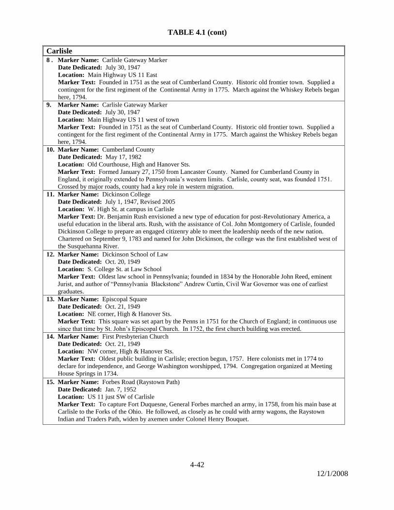
4-42
12/1/2008
TABLE 4.1 (cont)
Carlisle
8 . Marker Name: Carlisle Gateway Marker
Date Dedicated: July 30, 1947
Location: Main Highway US 11 East
Marker Text: Founded in 1751 as the seat of Cumberland County. Historic old frontier town. Supplied a
contingent for the first regiment of the Continental Army in 1775. March against the Whiskey Rebels began
here, 1794. 9. Marker Name: Carlisle Gateway Marker
Date Dedicated: July 30, 1947
Location: Main Highway US 11 west of town
Marker Text: Founded in 1751 as the seat of Cumberland County. Historic old frontier town. Supplied a
contingent for the first regiment of the Continental Army in 1775. March against the Whiskey Rebels began
here, 1794.
10. Marker Name: Cumberland County
Date Dedicated: May 17, 1982
Location: Old Courthouse, High and Hanover Sts.
Marker Text: Formed January 27, 1750 from Lancaster County. Named for Cumberland County in
England, it originally extended to Pennsylvania’s western limits. Carlisle, county seat, was founded 1751.
Crossed by major roads, county had a key role in western migration.
11. Marker Name: Dickinson College
Date Dedicated: July 1, 1947, Revised 2005
Location: W. High St. at campus in Carlisle
Marker Text: Dr. Benjamin Rush envisioned a new type of education for post-Revolutionary America, a
useful education in the liberal arts. Rush, with the assistance of Col. John Montgomery of Carlisle, founded
Dickinson College to prepare an engaged citizenry able to meet the leadership needs of the new nation.
Chartered on September 9, 1783 and named for John Dickinson, the college was the first established west of
the Susquehanna River.
12. Marker Name: Dickinson School of Law
Date Dedicated: Oct. 20, 1949
Location: S. College St. at Law School
Marker Text: Oldest law school in Pennsylvania; founded in 1834 by the Honorable John Reed, eminent
Jurist, and author of ―Pennsylvania Blackstone‖ Andrew Curtin, Civil War Governor was one of earliest
graduates.
13. Marker Name: Episcopal Square
Date Dedicated: Oct. 21, 1949
Location: NE corner, High & Hanover Sts.
Marker Text: This square was set apart by the Penns in 1751 for the Church of England; in continuous use
since that time by St. John’s Episcopal Church. In 1752, the first church building was erected.
14. Marker Name: First Presbyterian Church
Date Dedicated: Oct. 21, 1949
Location: NW corner, High & Hanover Sts.
Marker Text: Oldest public building in Carlisle; erection begun, 1757. Here colonists met in 1774 to
declare for independence, and George Washington worshipped, 1794. Congregation organized at Meeting
House Springs in 1734.
15. Marker Name: Forbes Road (Raystown Path)
Date Dedicated: Jan. 7, 1952
Location: US 11 just SW of Carlisle
Marker Text: To capture Fort Duquesne, General Forbes marched an army, in 1758, from his main base at
Carlisle to the Forks of the Ohio. He followed, as closely as he could with army wagons, the Raystown
Indian and Traders Path, widen by axemen under Colonel Henry Bouquet.
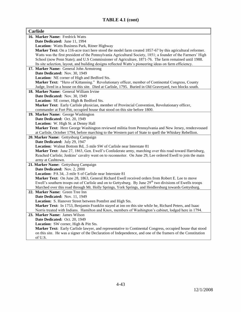
4-43
12/1/2008
TABLE 4.1 (cont)
Carlisle 16. Marker Name: Fredrick Watts
Date Dedicated: June 11, 1994
Location: Watts Business Park, Ritner Highway
Marker Text: On a 116-acre tract here stood the model farm created 1857-67 by this agricultural reformer.
Watts was the first president of the Pennsylvania Agricultural Society, 1851; a founder of the Farmers’ High
School (now Penn State); and U.S Commissioner of Agriculture, 1871-76. The farm remained until 1988.
Its site selection, layout, and building designs reflected Watts’s pioneering ideas on farm efficiency.
17. Marker Name: General John Armstrong
Date Dedicated: Nov. 30, 1949
Location: NE corner of High and Bedford Sts.
Marker Text: ―Hero of Kittanning.‖ Revolutionary officer, member of Continental Congress, County
Judge, lived in a house on this site. Died at Carlisle, 1795. Buried in Old Graveyard, two blocks south.
18. Marker Name: General William Irvine
Date Dedicated: Nov. 30, 1949
Location: SE corner, High & Bedford Sts.
Marker Text: Early Carlisle physician, member of Provincial Convention, Revolutionary officer,
commander at Fort Pitt, occupied house that stood on this site before 1800.
19. Marker Name: George Washington
Date Dedicated: Oct. 20, 1949
Location: W. High St. at Denny Hall
Marker Text: Here George Washington reviewed militia from Pennsylvania and New Jersey, rendezvoused
at Carlisle, October 1794, before marching to the Western part of State to quell the Whiskey Rebellion.
20. Marker Name: Gettysburg Campaign
Date Dedicated: July 29, 1947
Location: Walnut Bottom Rd, .5 mile SW of Carlisle near Interstate 81
Marker Text: June 27, 1863, Gen. Ewell’s Confederate army, marching over this road toward Harrisburg,
Reached Carlisle; Jenkins’ cavalry went on to reconnoiter. On June 29, Lee ordered Ewell to join the main
army at Cashtown.
21. Marker Name: Gettysburg Campaign
Date Dedicated: Nov. 2, 2000
Location: PA 34, .3 mile S of Carlisle near Interstate 81
Marker Text: On June 28, 1863, General Richard Ewell received orders from Robert E. Lee to move
Ewell’s southern troops out of Carlisle and on to Gettysburg. By June 29th
two divisions of Ewells troops
Marched over this road through Mt. Holly Springs, York Springs, and Heidlersburg towards Gettysburg.
22. Marker Name: Green Tree Inn
Date Dedicated: Nov. 11, 1949
Location: S. Hanover Street between Pomfret and High Sts.
Marker Text: In 1753, Benjamin Franklin stayed at inn on this site while he, Richard Peters, and Isaac
Norris treated with Indians. Hamilton and Knox, members of Washington’s cabinet, lodged here in 1794.
23. Marker Name: James Wilson
Date Dedicated: Oct. 20, 1949
Location: SW corner, High & Pitt Sts.
Marker Text: Early Carlisle lawyer, and representative to Continental Congress, occupied house that stood
on this site. He was a signer of the Declaration of Independence, and one of the framers of the Constitution
of U.S.
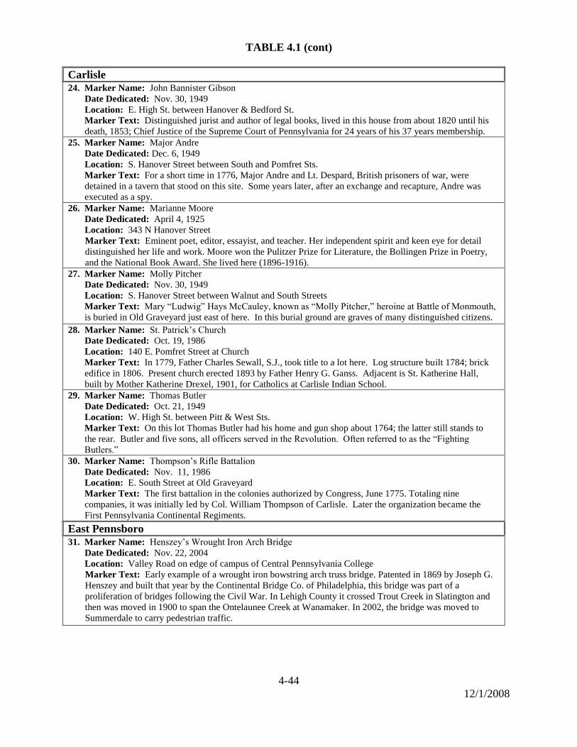
4-44
12/1/2008
TABLE 4.1 (cont)
Carlisle 24. Marker Name: John Bannister Gibson
Date Dedicated: Nov. 30, 1949
Location: E. High St. between Hanover & Bedford St.
Marker Text: Distinguished jurist and author of legal books, lived in this house from about 1820 until his
death, 1853; Chief Justice of the Supreme Court of Pennsylvania for 24 years of his 37 years membership.
25. Marker Name: Major Andre
Date Dedicated: Dec. 6, 1949
Location: S. Hanover Street between South and Pomfret Sts.
Marker Text: For a short time in 1776, Major Andre and Lt. Despard, British prisoners of war, were
detained in a tavern that stood on this site. Some years later, after an exchange and recapture, Andre was
executed as a spy.
26. Marker Name: Marianne Moore
Date Dedicated: April 4, 1925
Location: 343 N Hanover Street
Marker Text: Eminent poet, editor, essayist, and teacher. Her independent spirit and keen eye for detail
distinguished her life and work. Moore won the Pulitzer Prize for Literature, the Bollingen Prize in Poetry,
and the National Book Award. She lived here (1896-1916).
27. Marker Name: Molly Pitcher
Date Dedicated: Nov. 30, 1949
Location: S. Hanover Street between Walnut and South Streets
Marker Text: Mary ―Ludwig‖ Hays McCauley, known as ―Molly Pitcher,‖ heroine at Battle of Monmouth,
is buried in Old Graveyard just east of here. In this burial ground are graves of many distinguished citizens.
28. Marker Name: St. Patrick’s Church
Date Dedicated: Oct. 19, 1986
Location: 140 E. Pomfret Street at Church
Marker Text: In 1779, Father Charles Sewall, S.J., took title to a lot here. Log structure built 1784; brick
edifice in 1806. Present church erected 1893 by Father Henry G. Ganss. Adjacent is St. Katherine Hall,
built by Mother Katherine Drexel, 1901, for Catholics at Carlisle Indian School.
29. Marker Name: Thomas Butler
Date Dedicated: Oct. 21, 1949
Location: W. High St. between Pitt & West Sts.
Marker Text: On this lot Thomas Butler had his home and gun shop about 1764; the latter still stands to
the rear. Butler and five sons, all officers served in the Revolution. Often referred to as the ―Fighting
Butlers.‖
30. Marker Name: Thompson’s Rifle Battalion
Date Dedicated: Nov. 11, 1986
Location: E. South Street at Old Graveyard
Marker Text: The first battalion in the colonies authorized by Congress, June 1775. Totaling nine
companies, it was initially led by Col. William Thompson of Carlisle. Later the organization became the
First Pennsylvania Continental Regiments.
East Pennsboro 31. Marker Name: Henszey’s Wrought Iron Arch Bridge
Date Dedicated: Nov. 22, 2004
Location: Valley Road on edge of campus of Central Pennsylvania College
Marker Text: Early example of a wrought iron bowstring arch truss bridge. Patented in 1869 by Joseph G.
Henszey and built that year by the Continental Bridge Co. of Philadelphia, this bridge was part of a
proliferation of bridges following the Civil War. In Lehigh County it crossed Trout Creek in Slatington and
then was moved in 1900 to span the Ontelaunee Creek at Wanamaker. In 2002, the bridge was moved to
Summerdale to carry pedestrian traffic.
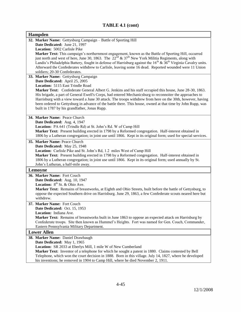
4-45
12/1/2008
TABLE 4.1 (cont)
Hampden 32. Marker Name: Gettysburg Campaign – Battle of Sporting Hill
Date Dedicated: June 21, 1997
Location: 5002 Carlisle Pike
Marker Text: This campaign’s northernmost engagement, known as the Battle of Sporting Hill, occurred
just north and west of here, June 30, 1863. The 22nd
& 37th
New York Militia Regiments, along with
Landis’s Philadelphia Battery, fought in defense of Harrisburg against the 16th
& 36th
Virginia Cavalry units.
Afterward the Confederates withdrew to Carlisle, leaving some 16 dead. Reported wounded were 11 Union
soldiers; 20-30 Confederates.
33. Marker Name: Gettysburg Campaign
Date Dedicated: April 25, 2005
Location: 5115 East Trindle Road
Marker Text: Confederate General Albert G. Jenkins and his staff occupied this house, June 28-30, 1863.
His brigade, a part of General Ewell's Corps, had entered Mechanicsburg to reconnoiter the approaches to
Harrisburg with a view toward a June 30 attack. The troops withdrew from here on the 30th, however, having
been ordered to Gettysburg in advance of the battle there. This house, owned at that time by John Rupp, was
built in 1787 by his grandfather, Jonas Rupp.
34. Marker Name: Peace Church
Date Dedicated: Aug. 4, 1947
Location: PA 641 (Trindle Rd) at St. John’s Rd. W of Camp Hill
Marker Text: Present building erected in 1798 by a Reformed congregation. Half-interest obtained in
1806 by a Lutheran congregation; in joint use until 1866. Kept in its original form; used for special services.
35. Marker Name: Peace Church
Date Dedicated: May 25, 1948
Location: Carlisle Pike and St. John’s Rd, 1.2 miles West of Camp Hill
Marker Text: Present building erected in 1798 by a Reformed congregation. Half-interest obtained in
1806 by a Lutheran congregation; in joint use until 1866. Kept in its original form; used annually by St.
John’s Lutheran, a half-mile away.
Lemoyne 36. Marker Name: Fort Couch
Date Dedicated: Aug. 10, 1947
Location: 8th
St. & Ohio Ave.
Marker Text: Remains of breastworks, at Eighth and Ohio Streets, built before the battle of Gettysburg, to
oppose the expected Southern drive on Harrisburg. June 29, 1863, a few Confederate scouts neared here but
withdrew.
37. Marker Name: Fort Couch
Date Dedicated: Oct. 15, 1953
Location: Indiana Ave.
Marker Text: Remains of breastworks built in June 1863 to oppose an expected attack on Harrisburg by
Confederate troops. Site then known as Hummel’s Heights. Fort was named for Gen. Couch, Commander,
Eastern Pennsylvania Military Department.
Lower Allen 38. Marker Name: Daniel Drawbaugh
Date Dedicated: May 1, 1965
Location: SR 2033 at Eberlys Mill, 1 mile W of New Cumberland
Marker Text: Inventor of a telephone for which he sought a patent in 1880. Claims contested by Bell
Telephone, which won the court decision in 1888. Born in this village. July 14, 1827, where he developed
his inventions; he removed in 1904 to Camp Hill, where he died November 2, 1911.

4-46
12/1/2008
TABLE 4.1 (cont)
Mechanicsburg 39. Marker Name: Cumberland Valley Railroad
Date Dedicated: May, 1992
Location: 4 Strawberry Alley
Marker Text: Incorporated in 1831. Completed, Lemoyne to Chambersburg, 1837; eventually, Harrisburg
to Virginia. For over 80 years, vital to Valley's economic life; merged into Pennsylvania R.R., 1919.
Passenger Station, Stationmaster's House here, built in the 1860s.
40. Marker Name: Irving Female College
Date Dedicated: Sept. 29, 1954
Location: E. Main St. near Filbert St.
Marker Text: Site of the College that was chartered in 1857, and named for Washington Irving, a trustee.
First women’s college in Pennsylvania to grant degrees in arts and sciences. It closed in 1929. 41. Marker Name: Simpson Ferry Road
Date Dedicated: Sept. 29, 1954
Location: Simpson St. near Walnut St.
Marker Text: Built about 1792. It extended from Michael Simpson’s Ferry on the Susquehanna to
Carlisle, following, at this point, a course later known as Simpson St. Used by many persons traveling to
western part of the State.
42. Marker Name: Union Church
Date Dedicated: Sept. 29, 1954
Location: East Main Street at Church
Marker Text: Oldest public building in Mechanicsburg. Built in 1825 on land given by Martin Rupp. As
provided in the charter, it has been used by many religious sects on payment of small fee.
Middlesex 43. Marker Name: Farthest North of Confederates
Date Dedicated: Oct. 26, 1929
Location: PA 34, 1 mile north of Carlisle Springs
Marker Text: The farthest north attained by any organized body of the Confederate army of Gen Robert E.
Lee was reached here at the farm of Joseph Miller on the morning of June 28, 1863. Hearing that Sterretts
Gap was occupied by Union Troops these outposts returned to their command at Carlisle. From these hills
the tide of the Confederate invasion receded, never to return.
Monroe 44. Marker Name: Williams Grove
Date Dedicated: Sept. 29, 1954
Location: SR 2011 ½ mile South of Williams Grove
Marker Text: This railroad junction became the site of the Great Grangers’ Interstate Picnic Exhibition,
founded 1874 by R.H. Thomas of the State Grange. The annual event drew an estimated 100,000 or more
people in a week by the 1890’s. The John Williams, built about 1799, stands.
New Cumberland 45. Marker Name: John W. Geary
Date Dedicated: June 10, 1995
Location: 3rd
and Bridge Streets in New Cumberland
Marker Text: Two-term Governor of Pennsylvania, 1867-73. Major General in Civil War. Colonel, 2nd
Pa. Regiment in Mexican War. Governor, Kansas Territory. First postmaster & first mayor of San
Francisco. His home was a block east at 308 Market Street.
46. Marker Name: Marcus A. Reno
Date Dedicated: September 9, 2007
Location: 3rd
& Reno Sts.
Marker Text: Maj., 7th U.S. Cavalry at Battle of Little Big Horn, 1876; Lt. Col. Geo. A. Custer & the
troops he led were killed, but Reno & most of his command survived. During the civil war, Reno helped
defend this region against Confederate invaders. His farm was near here.
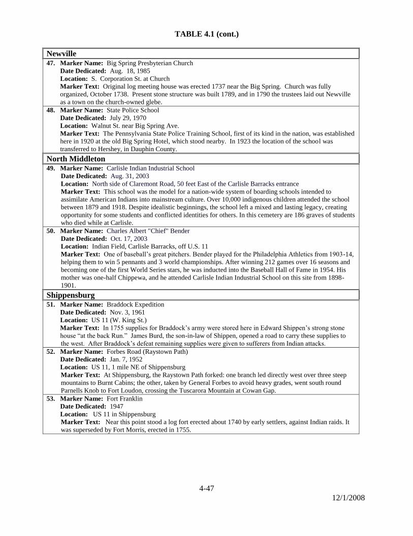
4-47
12/1/2008
TABLE 4.1 (cont.)
Newville 47. Marker Name: Big Spring Presbyterian Church
Date Dedicated: Aug. 18, 1985
Location: S. Corporation St. at Church
Marker Text: Original log meeting house was erected 1737 near the Big Spring. Church was fully
organized, October 1738. Present stone structure was built 1789, and in 1790 the trustees laid out Newville
as a town on the church-owned glebe.
48. Marker Name: State Police School
Date Dedicated: July 29, 1970
Location: Walnut St. near Big Spring Ave.
Marker Text: The Pennsylvania State Police Training School, first of its kind in the nation, was established
here in 1920 at the old Big Spring Hotel, which stood nearby. In 1923 the location of the school was
transferred to Hershey, in Dauphin County.
North Middleton
49. Marker Name: Carlisle Indian Industrial School
Date Dedicated: Aug. 31, 2003
Location: North side of Claremont Road, 50 feet East of the Carlisle Barracks entrance
Marker Text: This school was the model for a nation-wide system of boarding schools intended to
assimilate American Indians into mainstream culture. Over 10,000 indigenous children attended the school
between 1879 and 1918. Despite idealistic beginnings, the school left a mixed and lasting legacy, creating
opportunity for some students and conflicted identities for others. In this cemetery are 186 graves of students
who died while at Carlisle.
50. Marker Name: Charles Albert "Chief" Bender
Date Dedicated: Oct. 17, 2003
Location: Indian Field, Carlisle Barracks, off U.S. 11
Marker Text: One of baseball’s great pitchers. Bender played for the Philadelphia Athletics from 1903-14,
helping them to win 5 pennants and 3 world championships. After winning 212 games over 16 seasons and
becoming one of the first World Series stars, he was inducted into the Baseball Hall of Fame in 1954. His
mother was one-half Chippewa, and he attended Carlisle Indian Industrial School on this site from 1898-
1901.
Shippensburg 51. Marker Name: Braddock Expedition
Date Dedicated: Nov. 3, 1961
Location: US 11 (W. King St.)
Marker Text: In 1755 supplies for Braddock’s army were stored here in Edward Shippen’s strong stone
house ―at the back Run.‖ James Burd, the son-in-law of Shippen, opened a road to carry these supplies to
the west. After Braddock’s defeat remaining supplies were given to sufferers from Indian attacks. 52. Marker Name: Forbes Road (Raystown Path)
Date Dedicated: Jan. 7, 1952
Location: US 11, 1 mile NE of Shippensburg
Marker Text: At Shippensburg, the Raystown Path forked: one branch led directly west over three steep
mountains to Burnt Cabins; the other, taken by General Forbes to avoid heavy grades, went south round
Parnells Knob to Fort Loudon, crossing the Tuscarora Mountain at Cowan Gap.
53. Marker Name: Fort Franklin
Date Dedicated: 1947
Location: US 11 in Shippensburg
Marker Text: Near this point stood a log fort erected about 1740 by early settlers, against Indian raids. It
was superseded by Fort Morris, erected in 1755.
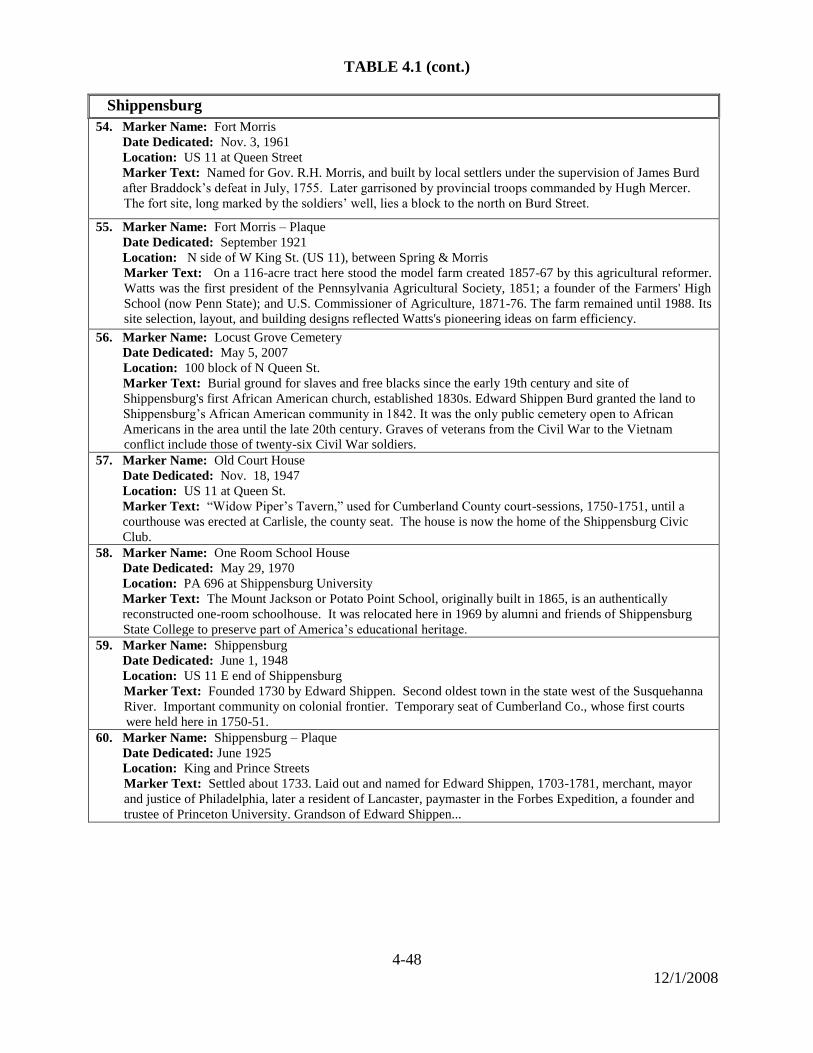
4-48
12/1/2008
TABLE 4.1 (cont.)
Shippensburg
54. Marker Name: Fort Morris
Date Dedicated: Nov. 3, 1961
Location: US 11 at Queen Street
Marker Text: Named for Gov. R.H. Morris, and built by local settlers under the supervision of James Burd
after Braddock’s defeat in July, 1755. Later garrisoned by provincial troops commanded by Hugh Mercer.
The fort site, long marked by the soldiers’ well, lies a block to the north on Burd Street.
55. Marker Name: Fort Morris – Plaque
Date Dedicated: September 1921
Location: N side of W King St. (US 11), between Spring & Morris
Marker Text: On a 116-acre tract here stood the model farm created 1857-67 by this agricultural reformer.
Watts was the first president of the Pennsylvania Agricultural Society, 1851; a founder of the Farmers' High
School (now Penn State); and U.S. Commissioner of Agriculture, 1871-76. The farm remained until 1988. Its
site selection, layout, and building designs reflected Watts's pioneering ideas on farm efficiency.
56. Marker Name: Locust Grove Cemetery
Date Dedicated: May 5, 2007
Location: 100 block of N Queen St.
Marker Text: Burial ground for slaves and free blacks since the early 19th century and site of
Shippensburg's first African American church, established 1830s. Edward Shippen Burd granted the land to
Shippensburg’s African American community in 1842. It was the only public cemetery open to African
Americans in the area until the late 20th century. Graves of veterans from the Civil War to the Vietnam
conflict include those of twenty-six Civil War soldiers.
57. Marker Name: Old Court House
Date Dedicated: Nov. 18, 1947
Location: US 11 at Queen St.
Marker Text: ―Widow Piper’s Tavern,‖ used for Cumberland County court-sessions, 1750-1751, until a
courthouse was erected at Carlisle, the county seat. The house is now the home of the Shippensburg Civic
Club.
58. Marker Name: One Room School House
Date Dedicated: May 29, 1970
Location: PA 696 at Shippensburg University
Marker Text: The Mount Jackson or Potato Point School, originally built in 1865, is an authentically
reconstructed one-room schoolhouse. It was relocated here in 1969 by alumni and friends of Shippensburg
State College to preserve part of America’s educational heritage.
59. Marker Name: Shippensburg
Date Dedicated: June 1, 1948
Location: US 11 E end of Shippensburg
Marker Text: Founded 1730 by Edward Shippen. Second oldest town in the state west of the Susquehanna
River. Important community on colonial frontier. Temporary seat of Cumberland Co., whose first courts
were held here in 1750-51.
60. Marker Name: Shippensburg – Plaque
Date Dedicated: June 1925
Location: King and Prince Streets
Marker Text: Settled about 1733. Laid out and named for Edward Shippen, 1703-1781, merchant, mayor
and justice of Philadelphia, later a resident of Lancaster, paymaster in the Forbes Expedition, a founder and
trustee of Princeton University. Grandson of Edward Shippen...
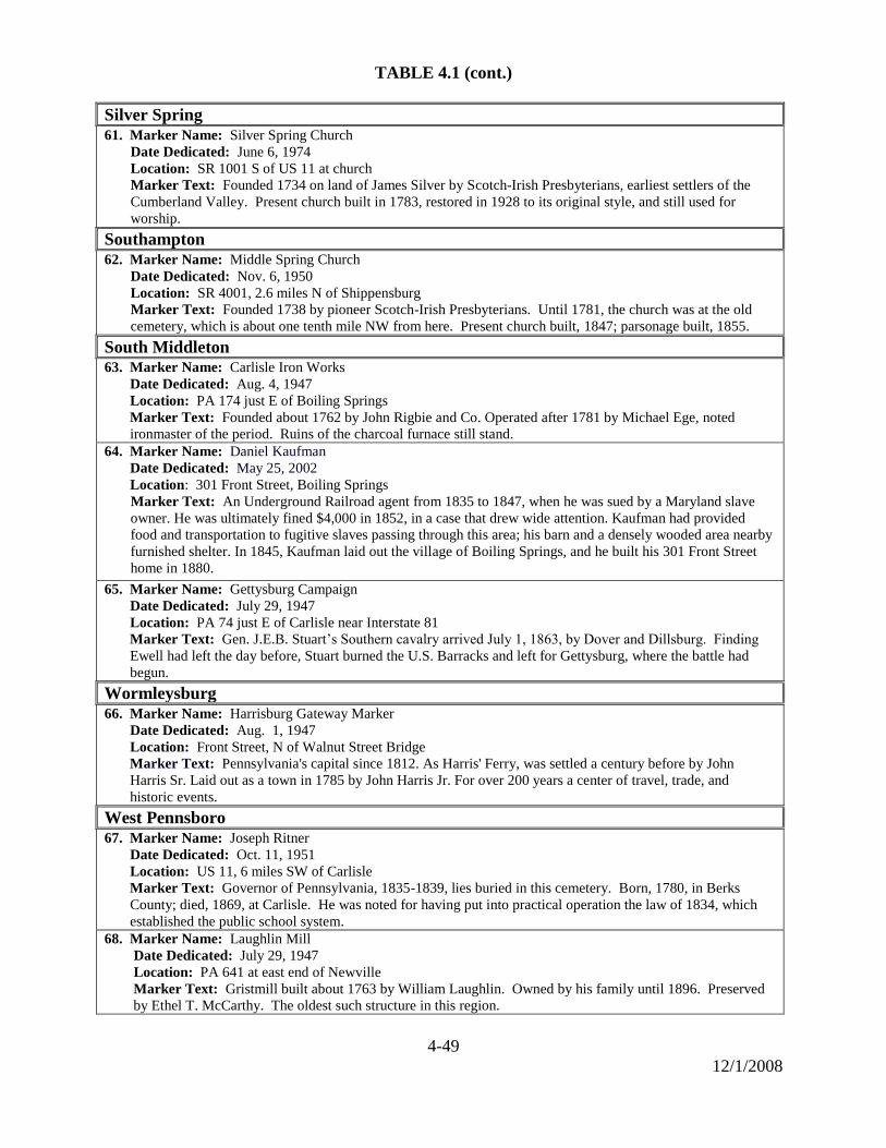
4-49
12/1/2008
TABLE 4.1 (cont.)
Silver Spring
61. Marker Name: Silver Spring Church
Date Dedicated: June 6, 1974
Location: SR 1001 S of US 11 at church
Marker Text: Founded 1734 on land of James Silver by Scotch-Irish Presbyterians, earliest settlers of the
Cumberland Valley. Present church built in 1783, restored in 1928 to its original style, and still used for
worship.
Southampton 62. Marker Name: Middle Spring Church
Date Dedicated: Nov. 6, 1950
Location: SR 4001, 2.6 miles N of Shippensburg
Marker Text: Founded 1738 by pioneer Scotch-Irish Presbyterians. Until 1781, the church was at the old
cemetery, which is about one tenth mile NW from here. Present church built, 1847; parsonage built, 1855.
South Middleton
63. Marker Name: Carlisle Iron Works
Date Dedicated: Aug. 4, 1947
Location: PA 174 just E of Boiling Springs
Marker Text: Founded about 1762 by John Rigbie and Co. Operated after 1781 by Michael Ege, noted
ironmaster of the period. Ruins of the charcoal furnace still stand.
64. Marker Name: Daniel Kaufman
Date Dedicated: May 25, 2002
Location: 301 Front Street, Boiling Springs
Marker Text: An Underground Railroad agent from 1835 to 1847, when he was sued by a Maryland slave
owner. He was ultimately fined $4,000 in 1852, in a case that drew wide attention. Kaufman had provided
food and transportation to fugitive slaves passing through this area; his barn and a densely wooded area nearby
furnished shelter. In 1845, Kaufman laid out the village of Boiling Springs, and he built his 301 Front Street
home in 1880.
65. Marker Name: Gettysburg Campaign
Date Dedicated: July 29, 1947
Location: PA 74 just E of Carlisle near Interstate 81
Marker Text: Gen. J.E.B. Stuart’s Southern cavalry arrived July 1, 1863, by Dover and Dillsburg. Finding
Ewell had left the day before, Stuart burned the U.S. Barracks and left for Gettysburg, where the battle had
begun.
Wormleysburg
66. Marker Name: Harrisburg Gateway Marker
Date Dedicated: Aug. 1, 1947
Location: Front Street, N of Walnut Street Bridge
Marker Text: Pennsylvania's capital since 1812. As Harris' Ferry, was settled a century before by John
Harris Sr. Laid out as a town in 1785 by John Harris Jr. For over 200 years a center of travel, trade, and
historic events.
West Pennsboro 67. Marker Name: Joseph Ritner
Date Dedicated: Oct. 11, 1951
Location: US 11, 6 miles SW of Carlisle
Marker Text: Governor of Pennsylvania, 1835-1839, lies buried in this cemetery. Born, 1780, in Berks
County; died, 1869, at Carlisle. He was noted for having put into practical operation the law of 1834, which
established the public school system.
68. Marker Name: Laughlin Mill
Date Dedicated: July 29, 1947
Location: PA 641 at east end of Newville
Marker Text: Gristmill built about 1763 by William Laughlin. Owned by his family until 1896. Preserved
by Ethel T. McCarthy. The oldest such structure in this region.
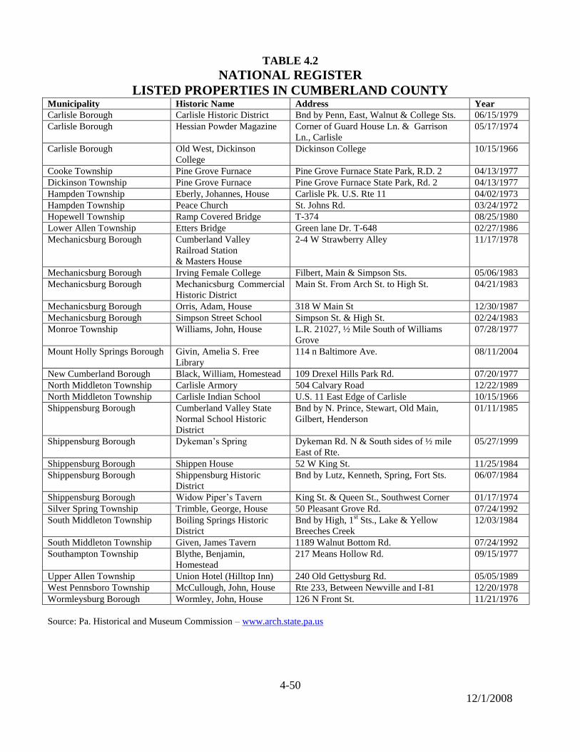
4-50
12/1/2008
TABLE 4.2
NATIONAL REGISTER
LISTED PROPERTIES IN CUMBERLAND COUNTY Municipality Historic Name Address Year
Carlisle Borough Carlisle Historic District Bnd by Penn, East, Walnut & College Sts. 06/15/1979
Carlisle Borough Hessian Powder Magazine Corner of Guard House Ln. & Garrison
Ln., Carlisle
05/17/1974
Carlisle Borough Old West, Dickinson
College
Dickinson College 10/15/1966
Cooke Township Pine Grove Furnace Pine Grove Furnace State Park, R.D. 2 04/13/1977
Dickinson Township Pine Grove Furnace Pine Grove Furnace State Park, Rd. 2 04/13/1977
Hampden Township Eberly, Johannes, House Carlisle Pk. U.S. Rte 11 04/02/1973
Hampden Township Peace Church St. Johns Rd. 03/24/1972
Hopewell Township Ramp Covered Bridge T-374 08/25/1980
Lower Allen Township Etters Bridge Green lane Dr. T-648 02/27/1986
Mechanicsburg Borough Cumberland Valley
Railroad Station
& Masters House
2-4 W Strawberry Alley 11/17/1978
Mechanicsburg Borough Irving Female College Filbert, Main & Simpson Sts. 05/06/1983
Mechanicsburg Borough Mechanicsburg Commercial
Historic District
Main St. From Arch St. to High St. 04/21/1983
Mechanicsburg Borough Orris, Adam, House 318 W Main St 12/30/1987
Mechanicsburg Borough Simpson Street School Simpson St. & High St. 02/24/1983
Monroe Township Williams, John, House L.R. 21027, ½ Mile South of Williams
Grove
07/28/1977
Mount Holly Springs Borough Givin, Amelia S. Free
Library
114 n Baltimore Ave. 08/11/2004
New Cumberland Borough Black, William, Homestead 109 Drexel Hills Park Rd. 07/20/1977
North Middleton Township Carlisle Armory 504 Calvary Road 12/22/1989
North Middleton Township Carlisle Indian School U.S. 11 East Edge of Carlisle 10/15/1966
Shippensburg Borough Cumberland Valley State
Normal School Historic
District
Bnd by N. Prince, Stewart, Old Main,
Gilbert, Henderson
01/11/1985
Shippensburg Borough Dykeman’s Spring Dykeman Rd. N & South sides of ½ mile
East of Rte.
05/27/1999
Shippensburg Borough Shippen House 52 W King St. 11/25/1984
Shippensburg Borough Shippensburg Historic
District
Bnd by Lutz, Kenneth, Spring, Fort Sts. 06/07/1984
Shippensburg Borough Widow Piper’s Tavern King St. & Queen St., Southwest Corner 01/17/1974
Silver Spring Township Trimble, George, House 50 Pleasant Grove Rd. 07/24/1992
South Middleton Township Boiling Springs Historic
District
Bnd by High, 1st Sts., Lake & Yellow
Breeches Creek
12/03/1984
South Middleton Township Given, James Tavern 1189 Walnut Bottom Rd. 07/24/1992
Southampton Township Blythe, Benjamin,
Homestead
217 Means Hollow Rd. 09/15/1977
Upper Allen Township Union Hotel (Hilltop Inn) 240 Old Gettysburg Rd. 05/05/1989
West Pennsboro Township McCullough, John, House Rte 233, Between Newville and I-81 12/20/1978
Wormleysburg Borough Wormley, John, House 126 N Front St. 11/21/1976
Source: Pa. Historical and Museum Commission – www.arch.state.pa.us
4-51
10/27/2008
Preserving the Past in the Present
Historic materials, artifacts, structures, sites, and streetscapes all offer windows to the
past and a physical connection to the heritage of a place. In Cumberland County, there
are many resources available, and organizations devoted to the preservation and
interpretation of the past. A Historic Resources Plan for Cumberland County is described
in Chapter 16.
Cumberland County Historical Society
The County Commissioners have designated the Cumberland County Historical Society
as the official county historical society. The Society is the official repository for the
county’s historic government records dating from the 1750’s. Much of the following
information was taken from the Cumberland County Historical Society’s (CCHS) website
(www.historicalsociety.com).
When James Hamilton, Jr., died in 1873, he left no heirs but he did leave a legacy that
has benefited historians and residents of Cumberland County for more than a century. In
his will he bequeathed a sum of $2,000 and a sixty-foot square lot in downtown Carlisle
for the establishment of a library. In writing the constitution of the Library, Hamilton's
executors interpreted his wishes that the Library was to be for "the advancement of
literature and the elucidation and preservation of the history of Cumberland County.‖179
Accordingly on April 17, 1874, a "Hamilton Library and Historical Association of
Cumberland County" was created, making the Society one of the first county historical
societies established in Pennsylvania.
For approximately 75 years, the Society's primary efforts were directed toward the
development of the research library and the reading of historical papers. During this
period, the Society also acquired historical materials primarily through gifts. They were
displayed in the reading room and in available space on the second floor, which
eventually evolved into gallery space.
After World War II, the development of a more effective museum became a priority.
Building expansions provided the additional space and efforts to build the museum
collections were made possible through the generous support of the community. In the
1970s, exhibits were developed and modern record keeping and conservation practices
were implemented. Educational programs also became a more integral part of the
Society’s activities with the establishment of an educational partnership with the county’s
school districts in 1989. As the organization’s activities began to expand, professional
staff was hired in the 1980s. It remains a non-profit organization with a Board of
Directors and approximately 1,500 members.
179
―Cumberland County Historical Society.‖ 14 Feb, 2008. <http://www.historicalsociety.com>.

4-52
10/27/2008
The Society’s headquarters remains at its original location at 21 N. Pitt Street in Carlisle.
The facility’s property expanded in 1992, when Mary Wheeler King bequeathed the Two
Mile House in South Middleton Township to the Society. Listed on the National Register
of Historic Places, the Two Mile House is a magnificent 1820 Federal limestone
residence. Situated on 5 acres, the landscaped grounds host the annual McLain Celtic
Festival and other activities. The Two Mile House is available to the public to conduct
meetings, receptions and parties. In 1997, the original facility on N. Pitt Street expanded
the building and doubled in size to provide more space for exhibition and education.
The Cumberland County Historical Society’s purpose is to collect, preserve, interpret and
promote research of the history of Cumberland County, Pennsylvania, from the first
Native Americans to the present. In order to carry out its mission, the Cumberland
County Historical Society maintains a research library and museum at its headquarters.
The library contains books, pamphlets, city directories, maps, tax lists, county records,
census records, newspapers, genealogical materials, manuscripts, and over 30,000
photographs that document local and county history.
The Society’s educational outreach extends to the greater community as well. Other
programs include slide/tape presentations on the museum’s collections, lectures on local
history topics, and workshops such as the award-winning Antiques Forum. In addition,
the Society has certified volunteer researchers who offer genealogical searches, property,
Indian School, and photograph research for a fee. Computer resources are also available
for members and guests doing research. Organized bus tours, teacher in-service
workshops, outreach lectures, and walking tours of local historic districts can also be
arranged.
United States Army Military History Institute
The U.S. Army Military History Institute (USAMHI) is the Army's official central
repository for historical source material. Located on Army Heritage Drive in Middlesex
Township, it was originally established in June of 1967 at the Carlisle Barracks and
called the Military History Research Collection.180
The USAMHI is now part of the
Army Heritage and Education Center located on a 56-acre tract donated by Cumberland
County in 1999.
In October, 2001 the Army officially designated the facility as the ―United States Army
Heritage and Education Center.‖ Its mission is to serve as the Army’s premier historical
research facility and provide educational outreach on Army history to the American
people.181
When it is fully developed, the Center will include five components.
1. Military History Institute 4. Army Heritage Trail
2. Visitor & Education Center 5. Conservation Laboratory
3. Army Heritage Museum
180
―United States Army Military History Institute.‖ 6 March 2003. <http://carlisle-www.army.mil/uramhi>. 181
―Army Heritage Center‖. 14 Feb 2008. www.armyheritage.org.

4-53
10/27/2008
The USAMHI collection contains over nine million items that document the history of
the U.S. Army and military history, including: books, rare books, periodicals,
photographs, manuscripts (diaries, letters, memoirs), military publications and manuals,
maps, and oral histories.
Local Historical Societies and Associations
Historical societies and organizations have been established in several municipalities in
Cumberland County. Their purpose is to preserve the heritage of the municipality
through preservation of landmarks and artifacts. These organizations also provide
educational programs, tours, and genealogical record data.
Existing Historic Preservation Districts
Five Cumberland County municipalities have successfully created Historic Preservation
Districts in their local ordinances.
Carlisle Borough
Mechanicsburg Borough
Shippensburg Borough
South Middleton Township
Upper Allen Township
Their historic areas communicate a sense place, and provide a window to the past, that
helps to establish a connection to the heritage of each locale. In addition, the aesthetic
and scale preserved provides a meaningful and attractive atmosphere in which to live and
work. These municipalities have successfully used strategies to protect historic resources
and promote them as assets to trigger cultural and economic improvement.
Camp Hill Historical Society
2145 Walnut Street
Camp Hill, PA 17011
Monroe Township Historical Society
1220 Boiling Springs Rd
Mechanicsburg, PA 17055
Historic Carlisle, Inc.
P.O. Box 1211
Carlisle, PA 17013-1211
Newville Historical Society
69 S. High Street
Newville, PA 17241
East Pennsboro Historical Society
410 Cherry Street
West Fairview, PA 17025
Shippensburg Historical Society
52 W. King Street
Shippensburg, PA 17257
Mechanicsburg Museum Association
3 W. Allen Street
Mechanicsburg, PA 17055
Gateway Historical Society
Lemoyne and Wormleysburg
c/o Borough of Lemoyne
510 Herman Avenue
Lemoyne, PA 17043


![Harrisburg telegraph. (Harrisburg, Pa.) 1917-06-01 [p 2] · TIMELY Cumberland Co. Bankers Organize to Sell Bonds Carlisle, Pa., June 1.?An organ- ration of Cumberland county bank-](https://static.fdocuments.net/doc/165x107/60a1d82765b3402ea2509fc2/harrisburg-telegraph-harrisburg-pa-1917-06-01-p-2-timely-cumberland-co-bankers.jpg)
