Historical tour of sites figuring in the Sioux Uprising in ... · OF SITES FIGURING IN THE SIOUX...
3
rii^:h^^tfWrJfl,S,i,.>iJ»,.i'vft. 1- '^u^u//f^^ C^ •C^'C'C ^ Aj&&/r ioh im6 slo^ MwN ^22 -l/J 7/ I SUA/6i:A^ JiP/Tf/? ii Lake D/omofic/ laMe ^ 'OZ/Ay ST i/S H\^Y /a Ar^AT£fR Will MAR M^ck^fCo. ^4 ^ I \ "' ^^V^*-:;^ DAKOTA CONFLICT OF 1862 MANUSCRIPTS COLLECTIONS MINNESOTA HISTORICAL SOCIETY. ST. PAUL, MINNESOTA 55102 A A:*§iii ,-*M.''.-....^>X* '/«/-* <^**^F^M!'i-'^''"w|iF _„• ..') s/..-^.,
-
Upload
truongmien -
Category
Documents
-
view
217 -
download
0
Transcript of Historical tour of sites figuring in the Sioux Uprising in ... · OF SITES FIGURING IN THE SIOUX...

rii^:h^^tfWrJfl,S,i,.>iJ»,.i'vft.
1- '^u^u//f^^ C^•C^'C'C^Aj&&/r ioh im6 slo^
MwN ^22-l/J 7/
I SUA/6i:A^
JiP/Tf/? ii
Lake
D/omofic/
laMe
^'OZ/Ay
ST
i/S H\^Y /a
Ar^AT£fR
WillMAR
M^ck^fCo. ^4
^
I
\
"' ^^V^*-:;^ DAKOTA CONFLICT OF 1862 MANUSCRIPTS COLLECTIONSMINNESOTA HISTORICAL SOCIETY. ST. PAUL, MINNESOTA 55102
A A:*§iii
,-*M.''.-....^>X* '/«/-* <^**^F^M!'i-'^''"w|iF ,_„•
..')
s/..-^.,
A^3^k&^^fi«feAi^aaii;>&'
/
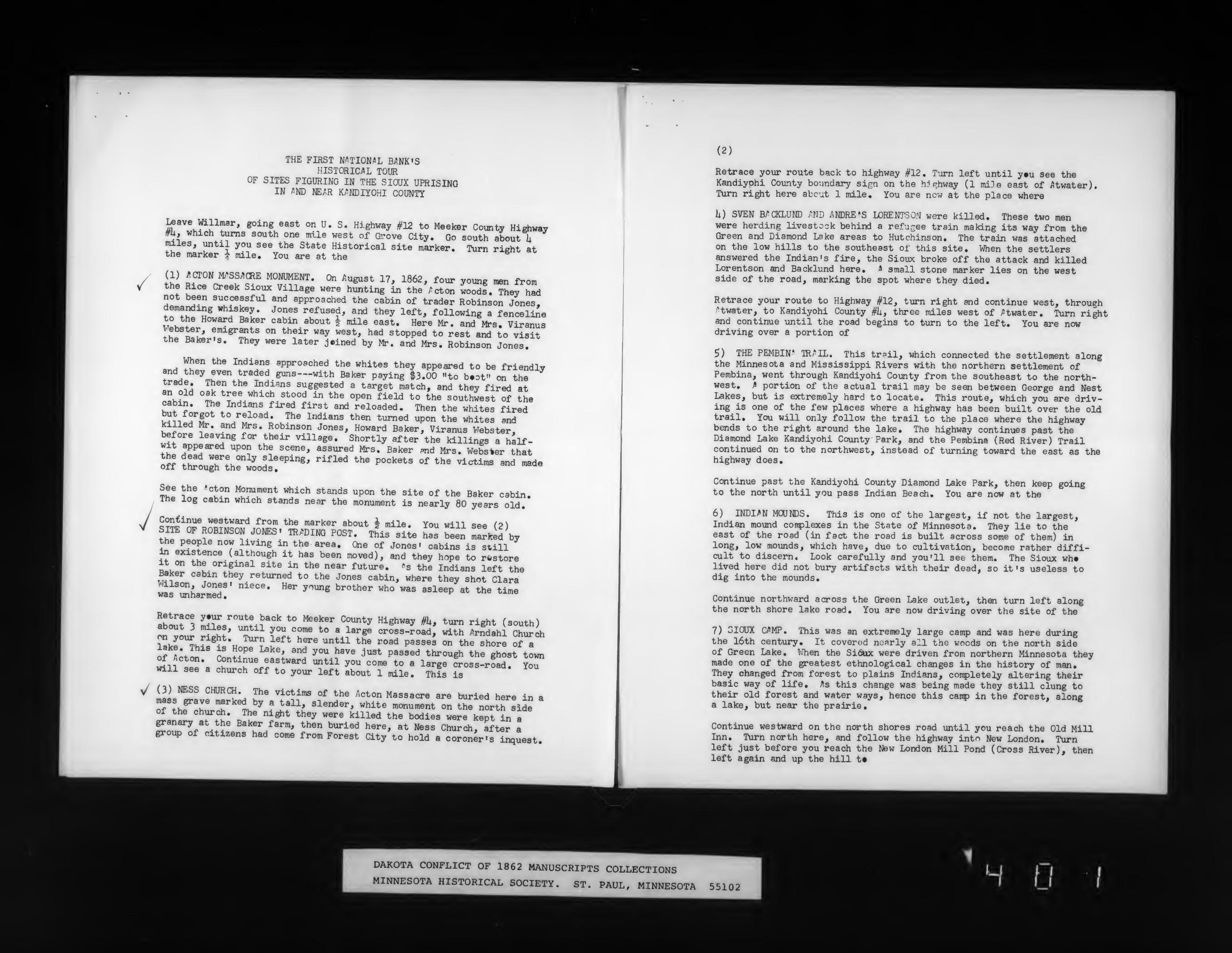
THE FIRST NATIONAL Bi»NK»SHISTORIC>^L TOUR
OF SITES FIGURING IN THE SIOUX UPRISINGIN /5ND mm K/NDIYOHI COUNTY
Leave Willmar, going east on U. S. Highway #12 to Meeker County Hirfiwaym, which turns south one mile west of Grove City. Go south about iimales, until you see the State Historical site marker. Turn right atthe marker t mile. You are at the
thi Ri'L°~r^ff.^ "°IJ^?*"- °" 'r^^* "' ^862, four young ^ fromthe Rice Creek Sioux Village were hunting in the ;^cton woods. They hadnot been successful and approached the cabin of trader Robinson Jones,demanding whiskey. Jones refused, and they left, following a fenceli^eto the Howard Baker cabin about | mile east. Here Mr. and Mrs. Viranus
ft^^lL !'^8^!?*^ °" t\«i'- ««y "«st, had stopped to rest and to visitthe Baker-s. They were later j.ined by Mr. and Mrs. Robinson Jones.
When the Indians approached the whites they appeared to be friendlvf!lL» ^r^.u^'^T^l^''^""""'' ^^^^ P'yi"e »3'00 "*° b.=t" on thetrade. Then the Indians suggested a target match, and they fired at
^«Mn °^^tree which stood in the open field to the southirest of thecabin. The Indians fired first and reloaded. Then the whites fired
^^«7f /t "^i J^^ ^"'^"''^ *^^ *"™°<* "P°n ^^he whites andkilled Mr. and Mrs. Robinson Jones, Howard Baker, Viranus Webster,before leaving for their village. Shortly after the killings a half-^ll "JPP^^^ "P°n the scene, assured Mrs. Baker ^d Mrs. Webster that
Irr tttiTtv.'^^^sleeping, rifled the pockets of the victims and madeoff through the woods.
Th! i!J® '°k?""""""^"t "^ich stands upon the site of the Baker cabin.The log cabin which stands near the monument is nearly 80 years old.
S^^?"*® westward from the marker about | mile. You will see (P\SHE OF ROBINSON JONES- IR.^DING POST. This site has been minted bythe people now living in the area. One of Jones' cabins is still^ f^^t^n^e. (although it has been moved), and they hope to restore
iliT ^^f.°''ie^^^ site in the near future, "s the Indians left theBaker cabin they returned to the Jones cabin, where they shot Clara
TOs mharmed! " ^"^ ^"'"^ ^''°^^^'' "^° "^^ ^*^^^P «* **»« time
ll^J,t°X J;?^/""*^?*°'' *° ^^^^"^ "^"^^y ^^^""^ ^' turn right (south)
TTJ. ^Z' T r^.^T *" " ^*''«" cross-road, with Arndahl Churii
lakr^J«^?«*». ? l"^^ ^f^ """^ ^^^ ''"^ passes °" the shore of a
ofl^t™ rltf^ i^"^ y°" ^"'^ ^^* P'^'^-^ *hr°^6h the ghost town
^n^f^*«Continue eastward until you come to a large ^oss-road. You^will see a church off to your left about 1 mile. This is
y/ (3) NESS CHDRCH. The victims of the Acton Massacre are buried here in aTlyfT 'Z''^.y f
'*^^' ^^^'^^^' "»»"« "«>""««t on the north Sideof the church. The night they were killed the bodies were kept in agranary at the Baker farm, then buried here, at Ness Church, after agroup of citizens had come from Forest City to hold a coroner's inquest.
y
(2)
Retrace your route back to highway #12. Turn left until y»u see theKandiyphi County boundary sign on the W f^hway (1 mi3e east of i^twater).Turn ri^t here abcut 1 mile. You are now at the place where
li) SVEN B/CKLUND i^ND ANDREWS LORENTSON were killed. These two menwere herding livestock behind a refu.:^ee train making its way from theGreen and Diamond Lake areas to Hutchinson. The train was attachedon the low hills to the southeast of this site. When the settlersanswered the Indian's fire, the Sioux broke off the attack and killedLorentson and Backlund here. A small stone marker lies on the westside of the road, marking the spot where they died.
Retrace your route to Highway #12, turn right and continue west, throughAtwater, to Kandiyohi County #ii, three miles west of j^twater. Turn rightand continue until the road begins to turn to the left. You are nowdriving over a portion of
5) THE PEMBIN* IRi^IL, This trPil, which connected the settlement alongthe Minnesota and Mississippi Rivers with the northern settlement ofPembina, went through Kandiyohi County from the southeast to the north-west. ^ portion of the actual trail may be seen between George and NestLakes, but is extremely hard to locate. This route, which you are driv-ing is one of the few places where a highway has been built over the oldtrail. You will only follow the trail to the place where the highwaybends to the right around the lake. The highway continues past theDiamond Lake Kandiyohi County Park, and the Pembina (Red River) Trailcontinued on to the northwest, instead of turning toward the east as thehighway does.
Continue past the Kandiyohi County Diamond Lake Park, then keep goingto the north until you pass Indian Beach. You are now at the
6) INDIAN MOJNDS. This is one of the largest, if not the largest,Indian mound coirplexes in the State of Minnesota. They lie to theeast of the road (in fact the road is built across some of them) inlong, low mounds, which have, due to cultivation, become rather diffi-cult to discern. Look carefully and you'll see them. The Sioux wh»lived here did not bury artifacts with their dead, so it»s useless todig into the mounds.
Continue northward across the Green Lake outlet, then turn left alongthe north shore lake road. You are now driving over the site of the
7) SIOUX CAMP. This was an extremely large camp and was here duringthe l6th century. It covered nearly all the woods on the north sideof Green Lake. When the Sidix were driven from northern Minnesota theymade one of the greatest ethnological changes in the history of man.They changed from forest to plains Indians, cotnpletely altering theirbasic way of life, ^s this change was being made they still clung totheir old forest and water ways, hence this camp in the forest, alonga lake, but near the prairie.
Continue westward on the north shores road until you reach the Old MillInn. Turn north here, and follow the highway into New London. Turnleft just before you reach the New London Mill Pond (Cross River), thenleft again and up the hill t#
•h;.
DAKOTA CONFLICT OF 1862 MANUSCRIPTS COLLECTIONSMINNESOTA HISTORICAL SOCIETY. ST. PAUL, MINNESOTA
• ;{•'>-• -'Li,.v- '--
.- J Hit
55102(..(
: \ ir'• k - - .
• »
^A^»>r.:>.'d
'.J -
[«14I yjf^A^.^
laM m'Jj^Ijti'fU^i'imti'fV''
/
/
v^
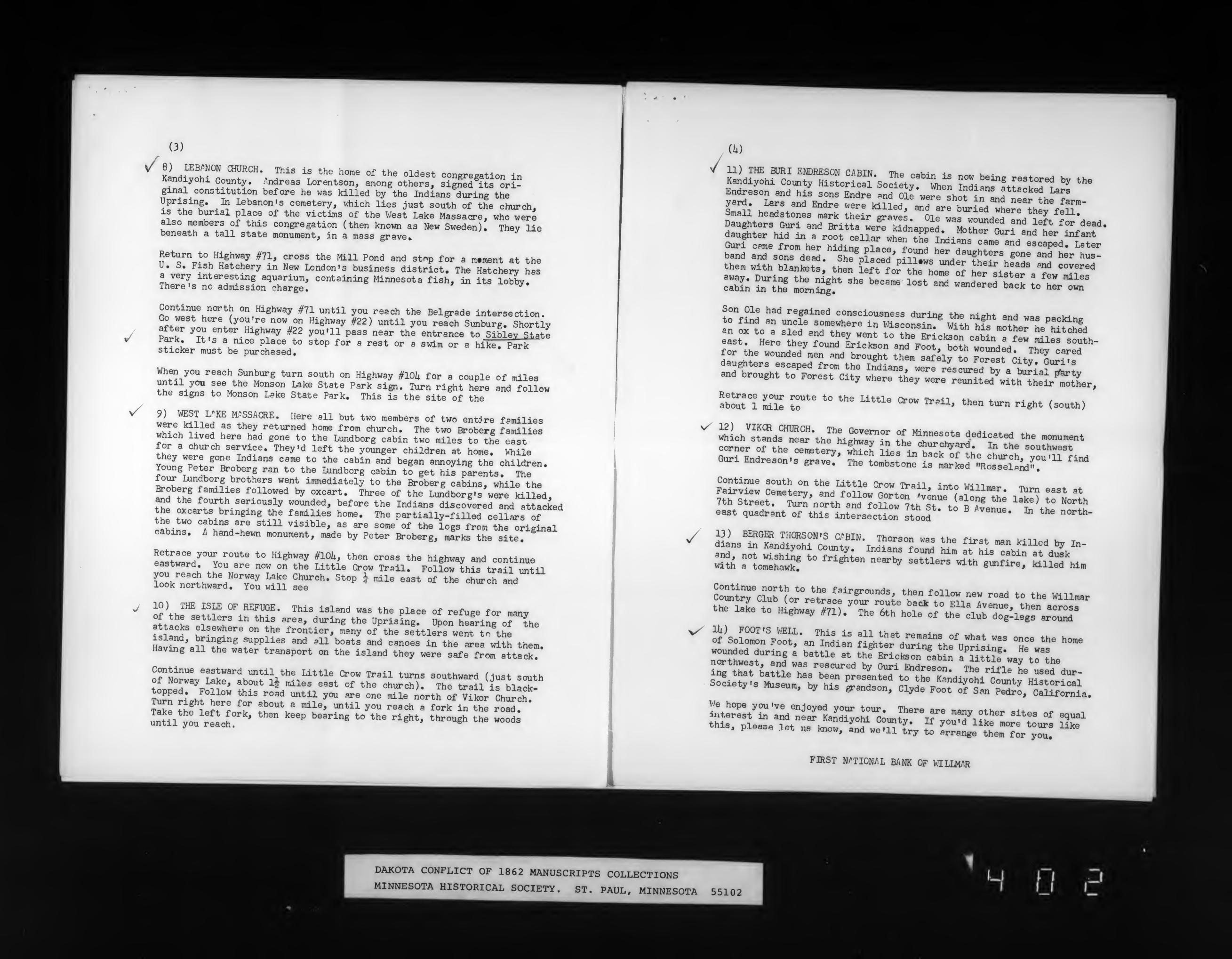
(3)
LLf^f"°™^'^"- '^'^^^ ^" ^"^^ h°"^ °f *he Oldest congregation inKandiyohi County, /indreas Lorentson, among others, simed its Sri-
ginal constitution before he was killed by the Indians during theUprising. In Isbanon's cemetery, which lies just south of the church,is the burial place of the victims of the West Lake Massacre, who werealso members of this congregation (then known as New Sweden). Thev liebeneath a tall state monument, in a mass grave.
Return to Highly #71, cross the Mill Pond and stop for a m.ment at theU, S. Fish Hatchery in New London's business district. The Hatchery hasa very interesting aquarium, containing Minnesota fish, in its lobbv.There's no admission charge.
Continue north on Highway #71 until you reach the Belgrade intersection.Go west here (you're now on Highway #22) until you reach Sunburg. Shortlvafter you enter Highway #22 you'll pass near the entrance to Sibiev St.tepark. It's a nice place to stop for a rest or a swim or a hike. Parksticker must be purchased.
When you reach Sunburg turn south on Highway #10U for a couple of milesuntil you see the Monson Lake State Park sign. Turn right here and followthe signs to Monson Lake State Park. This is the site of the
wl.'t^^^i'^H^SSACRE. Here all but two members of two entire families
«hH!h^- ^^ t^they returned home from church. The two Broberg familieswhich lived here had gone to the Lundborg cabin two miles to the eastfor a church service. They'd left the younger children at home. Vihile
TonL^pIL^"^ ? "" *=!"* *° ^^"^ '"^^^'^ ^"^ "^e^ annoying the children.Young Peter Broberg ran to the lundborg cabin to get his parents. The
C^Xi:^"f»^^f fi?^went immediately to the Broberg cabins, while theBroberg fanillies followed by oxcart. Three of the Lundborg >s were killed,and the fourth seriously wounded, before the Indians discovered and attacked
th« tur^K-*'''"^'"^^,"""•^"'^ *'°'^' Tl^^ partially-filled cellars ofthe two cabins are stiU visible, as are some of the logs from the originalcabins. A hand-hewn monument, made by Peter Broberg, mirks the sit^/
p!!+r^^°^''°''*^ *° "^^^''"y ^^°^' ^^'^ °'"°=s the highway and continueeastward. You are now on the Little Crow TraU. Follow this trail mtil
iTo.z:^^'^.'r^i „^s Lr^- ''"' ^ ^'^ --' °' '"^ churcrSd""'^
10) THE ISIE OF REFUGE. This island was the place of refuge for manvOf the settlers in this area, during the Uprising. Upon hefting of the
islanrf tl'^""}^^^°" t"^^ frontier, many of the sittlers went to\he
Havw'«ir?f"^supplies and all boats and canoes in the area with them.Having all the water transport on the island they were safe from atta^V
Continue eastward until the Little Crow Trail turns southward dust southof Norway l^ke, about l| miles east of the church). The^il is bla^-topped. Follow this road untU you are one mile north of Vikor Church
T^: thf'lefTfork'" T^'V "^i^'""*'' '""^ '•^^^^^ « forfin tt ^T'
Intil Jou reac^ '"'"" "^''^ ^'""''"^ *" **>" ^^S'^*' ''^^'^^^ ^^e woods
/(h)
11) THE BORI EMDRESON CABIN Tha ^oM„ <» ^ .
them with blanket then left for tir^""'^"^ t^^^ ^'''^' '"^ ^^^^'^'^
iTf^^ ^fregained consciousness during the night and was paokin<rto find an uncle somewhere in Wisconeiir. u-i+K uf_ 11: ,
P^°'°-'>8
for the wounded men and brought them safely to Forest nitvr„^,^=daughters escaped from the Indians, were rescued bv a ^^a?^'*and brought to Forest City where they were rSed^it^;iet'^,t,,
ab^t"! L°^ T' '° '""^ ^"^^ =^- ^^^' then turn right (south)
^ vhlch'stLs™-tHe M.taTi'' f. "^r^"*''^''^^'^ '^^ "™t
corner of the ^terv wMoH ^V^t churchyard. In the southwestGuri Endreson-s S^ The to^b^to ?'""' °Ll^^
^^''^c^^' y^""'^ ^^ioaun 9 grave. The tombstone is marked "Rosselsni",
Continue south on the Little Crow Trail <„+„ t.mti
wUh a toj^hawkf*° ^^^«^*"" "^^'^ ^«"1«^« '^th gunfire, killed him
ol'^^'^TiorrT^/^.'^f-Z^^^^^^ tothe Willmarthe lake to Highway #71).^ The 6th hoL^ortfe^^ib^oJlle'gs^V^I^"
^ E£t^V^^ n^^rd-r?r„piL-g! Twr --
So!i:S^s^\tm:V.1« --- cU%orrrS,-lS-LXte\°^t^S^::,^;:L^1.„a- rCounS--- -y Sites of equalthis, pa«a3« i«t us Know. Ir^.T^TU, Z ^rr:ie'\tm"°f:r*;^:
^'^
1 -. o'i*'
FIRST WTIOHAL BANK OF UILIilAR
DAKOTA CONFLICT OF 1862 MANUSCRIPTS COLLECTIONSMINNESOTA HISTORICAL SOCIETY. ST. PAUL, MINNESOTA
-•l-.
55102
• • ft, , ,y
'-i
'".L' " J^i2»^~y^^itt^^7^^ '^u