HISTORICAL BACKGROUND OF THE TRUST - reviste.ulbsibiu.roreviste.ulbsibiu.ro/trser/trser20/TRSER 20.2...
114
TRANSYLVANIAN REVIEW OF SYSTEMATICAL AND ECOLOGICAL RESEARCH 20.2 The Wetlands Diversity Editors Angela Curtean-Bănăduc & Doru Bănăduc Sibiu ‒ Romania 2018
Transcript of HISTORICAL BACKGROUND OF THE TRUST - reviste.ulbsibiu.roreviste.ulbsibiu.ro/trser/trser20/TRSER 20.2...

TRANSYLVANIAN REVIEW OF SYSTEMATICAL AND ECOLOGICAL
RESEARCH
20.2
The Wetlands Diversity
Editors
Angela Curtean-Bănăduc & Doru Bănăduc
Sibiu ‒ Romania
2018


TRANSYLVANIAN REVIEW OF SYSTEMATICAL AND ECOLOGICAL
RESEARCH
20.2
The Wetlands Diversity
Editors
Angela Curtean-Bănăduc & Doru Bănăduc
“Lucian Blaga” University of Sibiu, Faculty of Sciences,
Department of Ecology and Environment Protection
Published based mainly on some of the scientific materials presented at the sixth “Aquatic Biodiversity International Conference” ‒ Sibiu/Romania 2017
ESENIAS East and South
European network for Invasive Alien Species
Ecotur Sibiu
N.G.O.
“Lucian Blaga” University
of Sibiu
International Association
for Danube Research
Sibiu ‒ Romania
2018

Scientifical Reviewers
Mauricio ACOSTA GRINOK Universidad Católica del Norte, Antofagasta ‒ Chile.
Doru BĂNĂDUC “Lucian Blaga” University of Sibiu, Sibiu ‒ Romania.
Olena BILOUS Institute of Hydrobiology of National Academy of Sciences of Ukraine, Kiev ‒ Ukraine.
Alexandru BURCEA “Lucian Blaga” University of Sibiu, Sibiu ‒ Romania.
Angela CURTEAN-BĂNĂDUC “Lucian Blaga” University of Sibiu, Sibiu ‒ Romania.
Peter GLÖER Hetlingen, Germany.
Marian-Traian GOMOIU Romanian Academy, Bucharest – Romania
Thomas HEIN Austrian Academy of Sciences, Institute for Limnology, Mondsee ‒ Austria.
Mike JOY Te Kura Matauranga o nga Taonga a Papatuanuku Massey University, Palmerston North ‒ New Zealand.
Mirjana LENHARD Institute for Biological Research, Belgrade ‒ Serbia.
Laurisse LUKE Australian Rivers Institute, Griffith University, Nathan, Queensland ‒ Australia.
Sanda MAICAN Romanian Academy Institute of Biology, Bucharest ‒ Romania.
Pablo del MONTE Centro Interdisciplinario de Ciencias Marinas del IPN, La Paz ‒ México.
Roman ROMANOV Central Siberian Botanical Garden, Novosibirsk ‒ Russia.
Daniel SABAI Dar es Salaam University, Dar es Salaam ‒ Tanzania.
Teodora TRICHKOVA Bulgarian Academy of Sciences, Institute of Zoology, Sofia ‒ Bulgaria.

Editorial Assistants
John Robert AKEROYD Sherkin Island Marine Station, Sherkin Island ‒ Ireland.
Christelle BENDER Poitiers University, Poitiers ‒ France.
Cristina-Ioana BRUMAR “Lucian Blaga” University of Sibiu, Sibiu ‒ Romania.
Rebecca CLEMOW Montana University, Missula ‒ United States of America.
Cheryl FULLERTON Montana University, Missula ‒ United States of America.
Oriana IRIMIA-HURDUGAN “Alexandru Ioan Cuza” University of Iaşi, Iaşi ‒ Romania.
Marie-Eve LASSEUR Université Claude Bernard Lyon 1, Lyon – France.
Gautier LEROUX Campus La Salle St.-Christophe, Masseube ‒ France.
Skye MCGINTY Montana University, Missula, United States of America.
Camille NEVEUX University of Bourgogne, Dijon – France.
Nathaniel PAGE Agricultural Development and Environmental Protection in Transylvania Foundation, East Knoyle ‒ United Kingdom.
Skyler PAULI Montana University, Missula, United States of America.
Cristopher SEHY Montana University, Missula ‒ United States of America.
Skye SUMMERS Montana University, Missula ‒ United States of America.
Eduard STAN Montana University, Missula ‒ United States of America.
Simona STAN Montana University, Missula ‒ United States of America.

IN MEMORIAM
Great Union Day
(Romania, 1 December 1918)
On December 1, 1918, the National Assembly of Romanians of Transylvania, consisting of 1,228 elected representatives of the Romanians in Transylvania, Banat, Crişana and Maramureş, convened in Alba Iulia and decreed (by unanimous vote) “the unification of those Romanians and of all the territories inhabited by them with Romania”. On December 11, 1918, King Ferdinand signed the Law regarding the Union of Transylvania, Banat, Crişana, the Sătmar and Maramureş with the Old Kingdom of Romania, decreeing that “The lands named in the resolution of the Alba-Iulia National Assembly of the 18th of November 1918 are and remain forever united with the Kingdom of Romania”. The Great Union of 1918 was and remains the most sublime event in Romanian history. Its greatness resides in the fact that the fulfilment of the national unity is not the work of any politician, government or party; it is the historic deed of the whole Romanian nation, accomplished out of a powerful longing coming from the vivid awareness of the unity of the people and channelled by the political leaders for it to be led towards its aim with a remarkable political intelligence. The Great Union was not the result of Romania participating in the war. Neither the supporters of the Entente, nor those of the Central Powers did take into account the Russian revolution or the disintegration of the Austro-Hungarian monarchy. Their reasoning followed the traditional formula of the power relations between states: the victory of the Entente would bring back to Romania Bucovina, Transylvania and the Banat, while the victory of the Central Powers would bring back Bessarabia; one victory excluded the other so that no one could see how all these provinces could join the borders of the Old Kingdom simultaneously.
It was not a military victory that laid the foundation of Romania, but the will of the Romanian nation to create for itself the territorial and institutional framework that is the national state.
A historic necessity - the nation has to live within a national state - proved to be more powerful than any government or party, guilty of selfishness or incompetence and, putting the nation into motion, gave it that huge drive to overcome all the adversities and make its dream come true: the national state.
Florin Constantiniu
A Sincere History of the Romanian People
The Editors
Transylvanian Review of Systematical and Ecological Research
20.2 The Wetlands Diversity 2018
CONTENTS
Preface; The Editors The role of planktonic algae in the ecological assessment of storage-reservoirs of the Ili-Balkhash Basin (Kazakhstan);
Sophia BARINOVA, Elena KRUPA and Sophia ROMANOVA .............. 1. Ambophily in the dioecious weedy mangrove associate, Excoecaria agallocha (Euphorbiaceae);
Henry Jonathan KARAMSETTY and Jacob Solomon Raju ALURI ....... 15. Microbiological leaching; an environmentally friendly and cost effective method for extraction of metals; Mehdi GHOBEITI-HASAB and Zahra KHOSHNOOD ......................... 29. An indigenous species, Dreissena polymorpha (Pallas, 1771) (Mollusca, Bivalvia), as an invader in lake Büyük Akgöl; Naime ARSLAN, Seval KÖKMEN-ARAS and Deniz MERCAN ............. 39. Aquatic and semiaquatic Heteroptera (Nepomorpha) from the Strei River basin (Romania);
Daniela ILIE and Horea OLOSUTEAN ................................................. 51. Diversion of fishing pressure on the economically important species Barbus barbus (Linnaeus, 1758) to protect the community interest congeneric Barbus meridionalis Risso 1826, based on a decision-support management system;
Cristina CISMAŞ, Doru BĂNĂDUC and Angela CURTEAN-BĂNĂDUC .......................................................................................................................
63.
Using fishers knowledge in community based fisheries management in the river Nun Estuary, Niger Delta; Sabina NGODIGHA, Roland GBARABE and Ayeibatonworio AUGUSTINE ....................................................................................................................
75.
Natural values of the urban river valley and the possibilities of its development – Bystrzyca River valley study case (Poland);
Joanna SENDER and Weronika MAŚLANKO ....................................... 85.

Preface
In a global environment in which the climate changes are observed from few decades no more only through scientific studies but also through day by day life experiences of average people which feel and understand allready the presence of the medium and long-term significant change in the “average weather” all over the world, the most comon key words which reflect the general concern are: heating, desertification, rationalisation and surviwing. The causes, effects, trends and possibilities of human society to positively intervene to slow down this process or to adapt to it involve a huge variety of aproacess and efforts. With the fact in mind that these aproaces and efforts shuld be based on genuine scientific understanding, the editors of the Transylvanian Review of Systematical and Ecological Research series launch three annual volumes dedicated to the wetlands, volumes resulted mainly as a results of the Aquatic Biodiversity International Conference, Sibiu/Romania, 2007-2017. The therm wetland is used here in the acceptance of the Convention on Wetlands, signed in Ramsar, in 1971, for the conservation and wise use of wetlands and their resources. Marine/Coastal Wetlands - Permanent shallow marine waters in most cases less than six metres deep at low tide, includes sea bays and straits; Marine subtidal aquatic beds, includes kelp beds, sea-grass beds, tropical marine meadows; Coral reefs; Rocky marine shores, includes rocky offshore islands, sea cliffs; Sand, shingle or pebble shores, includes sand bars, spits and sandy islets, includes dune systems and humid dune slacks; Estuarine waters, permanent water of estuaries and estuarine systems of deltas; Intertidal mud, sand or salt flats; Intertidal marshes, includes salt marshes, salt meadows, saltings, raised salt marshes, includes tidal brackish and freshwater marshes; Intertidal forested wetlands, includes mangrove swamps, nipah swamps and tidal freshwater swamp forests; Coastal brackish/saline lagoons, brackish to saline lagoons with at least one relatively narrow connection to the sea; Coastal freshwater lagoons, includes freshwater delta lagoons; Karst and other subterranean hydrological systems, marine/coastal. Inland Wetlands - Permanent inland deltas; Permanent rivers/streams/creeks, includes waterfalls; Seasonal/intermittent/irregular rivers/streams/creeks; Permanent freshwater lakes (over eight ha), includes large oxbow lakes; Seasonal/intermittent freshwater lakes (over eight ha), includes floodplain lakes; Permanent saline/brackish/alkaline lakes; Seasonal/intermittent saline/brackish/alkaline lakes and flats; Permanent saline/brackish/alkaline marshes/pools; Seasonal/intermittent saline/brackish/alkaline marshes/pools; Permanent freshwater marshes/pools, ponds (below eight ha), marshes and swamps on inorganic soils, with emergent vegetation water-logged for at least most of the growing season; Seasonal/intermittent freshwater marshes/pools on inorganic soils, includes sloughs, potholes, seasonally flooded meadows, sedge marshes; Non-forested peatlands, includes shrub or open bogs, swamps, fens; Alpine wetlands, includes alpine meadows, temporary waters from snowmelt; Tundra wetlands, includes tundra pools, temporary waters from snowmelt; Shrub-dominated wetlands, shrub swamps, shrub-dominated freshwater marshes, shrub carr, alder thicket on inorganic soils; Freshwater, tree-dominated wetlands; includes freshwater swamp forests, seasonally flooded forests, wooded swamps on inorganic soils; Forested peatlands; peatswamp forests; Freshwater springs, oases; Geothermal wetlands; Karst and other subterranean hydrological systems, inland. Human-made wetlands - Aquaculture (e. g., fish/shrimp) ponds; Ponds; includes farm ponds, stock ponds, small tanks; (generally below eight ha); Irrigated land, includes irrigation channels and rice fields; Seasonally flooded agricultural land (including intensively managed or grazed wet meadow or pasture); Salt exploitation sites, salt pans, salines, etc.; Water storage areas, reservoirs/barrages/dams/impoundments (generally over eight ha); Excavations; gravel/brick/clay pits; borrow pits, mining pools; Wastewater treatment areas, sewage farms, settling ponds, oxidation basins, etc.; Canals and drainage channels, ditches; Karst and other subterranean hydrological systems, human-made.

The editors of the Transylvanian Review of Systematical and Ecological Research started and continue the annual sub-series (Wetlands Diversity) as an international scientific debate platform for the wetlands conservation, and not to take in the last moment, some last heavenly “images” of a perishing world … This 20.2 volume included variated researches from diverse wetlands around the world.
The subject areas ( ) for the published studies in this volume.
No doubt that this new data will develop knowledge and understanding of the ecological status of the wetlands and will continue to evolve. Acknowledgements The editors would like to express their sincere gratitude to the authors and the scientific reviewers whose work made the appearance of this volume possible.
The Editors
Editorial Office:
“Lucian Blaga” University of Sibiu, Faculty of Sciences, Department of Ecology and Environment Protection, Dr. Ion Raţiu Street 5-7, Sibiu, Sibiu County, Romania, RO-550012, Angela Curtean-Bănăduc ([email protected], [email protected])
(ISSN-L 1841 – 7051; online ISSN 2344 – 3219)
The responsability for the published data belong to the authors. All rights reserved. No part of this publication may be reproduced or transmitted in any form or by any means, electronic or mechanical, including photocopying, recording or by any information storage and retrieval system, without permission in writing from the Editors of Transylv. Rev. Syst. Ecol. Res.


Transylv. Rev. Syst. Ecol. Res. 20.2 (2018), "The Wetlands Diversity" 1
THE ROLE OF PLANKTONIC ALGAE IN THE ECOLOGICAL ASSESSMENT OF STORAGE-RESERVOIRS OF THE ILI-BALKHASH BASIN
Sophia BARINOVA *, Elena KRUPA ** and Sophia ROMANOVA ***
* Institute of Evolution, University of Haifa, Mount Carmel, Abba Khoushi Avenue 199, Haifa, Israel,IL-3498838, [email protected] ** Republican State Enterprise on the Right of Economic Use, Institute of Zoology, Al-Farabi Street 71, Almaty, Kazakhstan, KZ-050060, [email protected] *** Al-Farabi Kazakh National University, Al-Farabi Street 71, Almaty Kazakhstan, KZ-050040, [email protected]
DOI: 10.2478/trser-2018-0008 KEYWORDS: phytoplankton, nutrients, wastewater, heavy metals, Kazakhstan. ABSTRACT The largest wastewater treatment systems include Sorbulak and Kurty reservoirs, and
the small storage ponds were studied in the summer of 2017 and characterized mainly by organic pollution. Phytoplankton communities were represented by species tolerant of organic and toxic pollution. Cyanobacteria dominated in the reservoirs, and dinophyte algae were only in the Kurty Reservoir. According to the results of CCA analysis, only Cr and certain nutrients had a significant effect on the abundance of algae. A statistically positive significant association between the Shannon index and the average algal cell mass was established. The results obtained are a particular example reflecting the non-linearity of changes in plankton communities in the gradient of nutrient loading and eutrophication of aquatic ecosystems.
ZUSAMMENFASSUNG: Die Rolle der Planktonalgen in der ökologischen Beurteilung von Staubecken im Einzugsgebiet des Ili-Balkhash.
Die größten Abwasserbehandlungssysteme, das Sorbulak und Kurty Reservoir sowie kleinere Wasserspeicher, vor allem solche, die sich durch organische Verschmutzung kennzeichnen, wurden im Sommer 2017 untersucht. Die Phytoplankton-Gemeinschaften waren durch Arten vertreten, die gegenüber organischer und toxischer Verschmutzung tolerant sind. Cyanobacterien dominierten in den Stauseen, während Dinophyten nur im Kurty-Reservoir vorkamen. Nach den Ergebnissen der CCA-Analyse hatten nur Cr und einige Nährstoffe einen signifikanten Einfluss auf die Abundanz der Algen. Es wurde ein statistisch positiv signifikanter Zusammenhang zwischen dem Shannon-Index und der durchschnittlichen Algenzellmasse festgestellt. Die erzielten Ergebnisse stellen ein besonderes Beispiel dar, das die Nichtlinearität von Veränderungen in Planktongemeinschaften in Bezug auf den Grad der Nährstoffbelastung und der Eutrophierung aquatischer Ökosysteme widerspiegelt.
REZUMAT: Rolul algelor planctonice în evaluarea ecologică a lacurilor de acumulare din bazinul Ili-Balkhash.
Cele mai mari sisteme de epurare a apelor uzate, inclusiv Sorbulak, rezervoarele Kurty și mici iazuri de depozitare, au fost studiate în vara anului 2017 fiind caracterizate în principal de poluarea organică. Comunitățile fitoplanctonice au fost reprezentate de specii care tolerează poluarea organică și toxică. Cianobacteriile au dominat rezervoarele, algele dinofile numai rezervorul Kurty. Conform rezultatelor analizei CCA, doar Cr și substanțele nutritive au avut un efect semnificativ asupra abundenței algelor. A fost stabilită o asociere pozitivă semnificativă statistic între indicele Shannon și masa medie a celulelor algelor. Rezultatele reprezintă un exemplu care reflectă nelinearitatea schimbărilor în comunitățile de plancton în gradientul încărcării cu nutrienți și al eutrofizării ecosistemelor acvatice.

S. Barinova et al. – Planktonic algae of storage-reservoirs of the Ile-Balkhash Basin (1 ~ 14) 2
INTRODUCTION Planktonic algae are widely used in ecological assessments of water quality (Poikane et al., 2011, 2015; Momeu et al., 2012; Stevenson, 2014). It is very important to know about algal diversity in inland waters because most of algal species can be used as environmental indicators. The algal diversity in the lakes of Kazakhstan is partly studied (Barinova et al., 2009; Krupa et al., 2016; Barinova and Krupa, 2017), the contaminated water reservoirs phytoplankton research is now in an initial stage but still as important for wastewater storages ecosystem self-purification capacity assessment. Almaty, the largest city in the Ili-Balkhash Basin, is the core of the Almaty agglomeration with a total population of 2.5 million. The water supply of the city and its environs are carried out at the expense of underground artesian basins, as well as the mountain river Ulken Almaty. The sewage of Almaty and its environs is mixed in the composition. The main part – up to 35-40%, are domestic sewage. The share of industrial effluents in the total volume of sewage in recent decades has decreased from 35% to 11%. Despite the population growth, in the period from 1998 to 2004, specific water consumption was decreased from 288.0 to 126.0 one day-1 per person. Accordingly, the volume of discharged effluents decreased from 135.7 to 101.5 million m3 (Dostay and Tyumenev, 2009), which is mainly due to an increase in the number of equipments for consumed water. The sewage waters of Almaty and the surrounding areas are stored in the Sorbulak storage reservoir (Figs. 1 and 2) after preliminary treatments at sewage treatment plants. Its filling began in 1973. The Sorbulak storage reservoir is located in a natural depression of the relief of the foothill plain at an altitude of about 590-620 m a.s.l. in 40 km north of Almaty. Its maximum depth is 20 m, the water surface is about 58 km2. The potential volume of the reservoir, taking into account the height of the dam is about 1,000 million m3 at the altitude of its surface of about 622 m. Sorbulak is one of the largest wastewater storage facilities. In the event of a threat of overflow, part of the waste water, bypassing Sorbulak, along the Right Bank Sorbulak Canal (RBSC) (Figs. 1 and 5a) is discharged into storage ponds and further into the Ili River. RBSC ponds are shallow, with maximum depths of no more than six-seven m. Their area varies considerably and depends on the volume of wastewater discharged. The largest are pond no. seven and pond no. eight, the most terminal in the system (Figs. 1, 3 and 4). The sewage is chlorinated before discharging to the river Ili that poses an additional serious threat to the biota and the river ecosystem as a whole. The mass mortality of aquatic invertebrates and fish was noted by us in 1996, on the Ili River section about 70 km below the confluence of the RBS Canal (Matmuratov et al., 1999). The Ili River flows into lake Balkhash, one of the largest fishery reservoirs in Kazakhstan, so the quality of the water in the river also affects the ecological situation in the Balkhash Lake.

Transylv. Rev. Syst. Ecol. Res. 20.2 (2018), "The Wetlands Diversity" 3
Figure 1: Schematic diagram of the location of wastewater reservoirs (a)
and the Kurty Reservoir (b).
Figure 2: The Sorbulak Reservoir (a)
and the coastal zone of the reservoir with blue-green bloom (b).
Figure 3: Storage pond RBSC no. seven (a)
the bloom of cyanobacteria throught the water area of the reservoir (b).

S. Barinova et al. – Planktonic algae of storage-reservoirs of the Ile-Balkhash Basin (1 ~ 14) 4
Figure 4: The storage pond RBSC no. eight;
in the background there are groups of cormorants and gulls.
Figure 5: The channel of emergency discharge of sewage
between storage ponds RBSS no. seven and no. eight (a); reservoir Kurty (b).
The storage reservoirs are places of accumulation of water birds. Many birds stop here on migration, some winters (Auezov et al., 1980). At a distance of 12 km from the Sorbulak Reservoir, the Kurty River flows, on which the canyon type, the Kurty Reservoir is located. It is long and narrow (Fig. 5b). Its depth is about 30 m, the surface area is 4.2 km2. Sewage in the Kurty River and the reservoir is not discharged. But it is potentially possible to get contaminants into Kurty through an underground runoff, as a result of drive impact of technologically polluted aquifer formation in the zone of the Sorbulak large sewage reservoir (Dostay and Tyumenev, 2009). The purpose of this work is a comparative assessment of the ecological state of storage reservoirs of the RBSC system and the Kurty Reservoir on the basis of quantitative variables of phytoplankton and water chemistry. MATERIAL AND METHODS Phytoplankton studies of the reservoirs of the RBSC system and the Kurty Reservoir were carried out in July of 2017. A total of 20 phytoplankton samples of one liter from the surface layer of the waters were taken. The samples were fixed with 4% formaldehyde. Samples were processed using standard methods for species definition with using conventional handbooks. In parallel, water samples were taken to determine the chemical composition, the content of biogenic elements and heavy metals.

Transylv. Rev. Syst. Ecol. Res. 20.2 (2018), "The Wetlands Diversity" 5
The measures of the temperature and pH values of the surface water layers were taken in the field environment. Water transparency was measured with Secchi disk. Coordinate referencing of the stations was done by Garmin eTrex GPS-navigators. The samples for heavy metals were fixed in the site by adding nitric acid. All collected samples were transported to the lab in an icebox. Conventional methods of chemical analysis of water were used. Water samples were analyzed in three – four replications. The error of estimate for major ions in the water was 0.5-5.0%, depending on the analyte. Concentrations of heavy metals were determined by AAS-1N atomic absorption spectrophotometer (Carl Zeiss Industrielle Messtechnik GmbH, Germany). The device allows for the detection of the various chemical elements in complex matrices, including those in the sea and grey water and in the biological objects in micro-trace quantities. Test-sensitivity of AAS-1N spectrophotometer is 0.001-0.0025% mass. (Semenova, 1977; Fomin, 1995) The diversity indices of Shannon and W-statistic Clarke were calculated in the Primer 5.0 program. Canonical Correspondence Analysis plots were statistically generated in the CANOCO 6.0 program. Nonparametric correlation analysis and spatial mapping in wafer plots was done on Statistica 12.0.
RESULTS The biggest depth of the Sorbulak Reservoir all along the research was 17 m, the Kurty Reservoir – 26 m, the RBSC ponds – not over 6.5 m. In all reservoirs macrophytes are underdeveloped. The water color varies from bright green to grassy-green. The sediments are black silt in Sorbulak smelling of hydrogen sulfide, in the Kurtinsky Reservoir – gray mud. In the RBSC ponds at the bottom was a thick layer of blue-green algae. The maximum transparency of water was recorded in the reservoirs Sorbulak and Kurty. The water temperature was 25.8-28.0°C (Tab. 1). All reservoirs were slightly mineralized with a maximum value of TDS in the Sorbulak Reservoir (Tab. 1). In Sorbulak and RBSC ponds, water was of chloride class, in the reservoir of Kurty – sulfate class, sodium group. The water of the ponds was soft, in the reservoirs of Kurty and Sorbulak, it was of medium hardness. The amount of easy oxidizable organic matter was at middle level and in the pond RBSC no. seven at an elevated level. The RBSC no. seven pond was also characterized by the highest content of nitrites and phosphates in its water. The content of heavy metals was insignificant. The exception was the pond RBSC no. seven, in the water of which increased concentrations of copper and zinc were recognized.
Table 1: The environmental variables of the studied reservoirs of the Almaty region, July 2017.
Variables units Sorbulak Reservoir RBSC no. 7 RBSC no. 8 Kurty Reservoir
Depth m 7.2 ± 1.9 5.0 ± 1.2 2.9 ± 0.6 18.3 ± 3.3 Transparency m 1.5 ± 0.3 0.2 ± 0.1 0.5 ± 0.03 2.0 ± 0.2 Temperature °C 27.0 ± 0.2 28.5 ± 0.01 27.8 ± 1.1 26.1 ± 0.1 pH 9.0 ± 0.6 8.5 ± 0.01 9.4 ± 0.06 8.3 ± 0.2 TDS mg dm-3 1,234.3 ± 37.8 517.5 ± 20 584.1 ± 40.1 886.7 ± 67.3 Hardness mg-eq. dm-3 4.9 ± 0.03 2.3 ± 0.01 2.8 ± 0.3 5.3 ± 0.1 BOD mg O2 dm-3 11.2 ± 0.04 21.8 ± 0.1 10.9 ± 0.9 5.6 ± 0.3 Si mg dm-3 2.1 ± 0.4 8.7 ± 0.1 8.3 ± 0.1 5.3 ± 0.2 NO2 mg dm-3 0.038 ± 0.004 1.06 ± 0.02 0.020 ± 0.009 0.158 ± 0.004

S. Barinova et al. – Planktonic algae of storage-reservoirs of the Ile-Balkhash Basin (1 ~ 14) 6
Table 1 (continued): The environmental variables of the studied reservoirs of the Almaty region, July 2017.
Variables units Sorbulak Reservoir RBSC no. 7 RBSC no. 8 Kurty Reservoir
NO3 mg dm-3 0.67 ± 0.33 4.63 ± 1.36 0.35 ± 0.23 6.74 ± 0.49 NH4 mg dm-3 0.58 ± 0.70 0.47 ± 0.07 0.35 ± 0.13 0.26 ± 0.10 PO4 mg dm-3 0.15 ± 0.07 0.80 ± 0.27 0.28 ± 0.02 0.0008±0.0008 Fe mg dm-3 0.70 ± 0.14 0.93 ± 0.19 1.20 ± 0.40 0.44 ± 0.04 Mn mg dm-3 0.005 ± 0.001 0.0 ± 0.0 0.003 ± 0.001 0.005 ± 0.001 Cd mg dm-3 0.0 ± 0.0 0.0 ± 0.0 0.0 ± 0.0 0.0 ± 0.0 Cr mg dm-3 0.007 ± 0.0003 0.007±0.0001 0.006±0.0006 0.007 ± 0.0003 Cu mg dm-3 0.001 ± 0.0008 0.043 ± 0.042 0.0 ± 0.0 0.0006±0.0003 Ni mg dm-3 0.0051 ± 0.0003 0.006 ± 0.003 0.005±0.0001 0.0046±0.0004 Pb mg dm-3 0.0 ± 0.0 0.0 ± 0.0 0.0 ± 0.0 0.0 ± 0.0 Zn mg dm-3 0.012 ± 0.003 0.037 ± 0.030 0.010 ± 0.006 0.009 ± 0.005
The species richness of the phytoplankton was low (Tab. 2). In total 18 taxa, six species of diatoms, five greens, two charophytic algae, three dinophytes, and two cyanobacteria were identified. The abundant species in Sorbulak and RBSC ponds cyanobacteria Microcystis flosaquae and Pseudanabaena mucicola, whereas in the Kurty Reservoir dinophyte species Peridinium cinctum and Ceratium hirundinella were prevalent in total cell numbers.
Table 2: Species composition of phytoplankton of wastewater storage reservoirs and the Kurty Reservoir, July 2017.
Taxa Sorbulak Reservoir
RBSC no. 7
RBSC no. 8
Kurty Reservoir
Bacillariophyta Encyonema ventricosum (Agardh C.) Grunow + Diatoma elongata (Lyngbye) Agardh C. + Fragilaria capucina Desmazières + Navicula tripunctata (Müller O. F.) Bory + Pleurosigma salinarum (Grunow) Grunow + Surirella minuta Brébisson ex Kützing + Chlorophyta Coelastrum microporum Nägeli + Korshikoviella limnetica (Lemm.) Silva P. C. + Pseudopediastrum boryanum Hegewald E. + Pediastrum duplex Meyen + Desmodesmus communis Hegewald E. + Charophyta Cosmarium botrytis Meneghini ex Ralfs + Staurastrum gracile Ralfs ex Ralfs + Cyanobacteria Microcystis flosaquae (Wittrock) Kirchner + + + Pseudanabaena mucicola Schwabe + + + Dinophyta Ceratium hirundinella (Müller O. F.) Dujardin + + + Peridinium bipes Stein + Peridinium cinctum (Müller O. F.) Ehrenberg + Total 10 3 2 9
Transylv. Rev. Syst. Ecol. Res. 20.2 (2018), "The Wetlands Diversity" 7
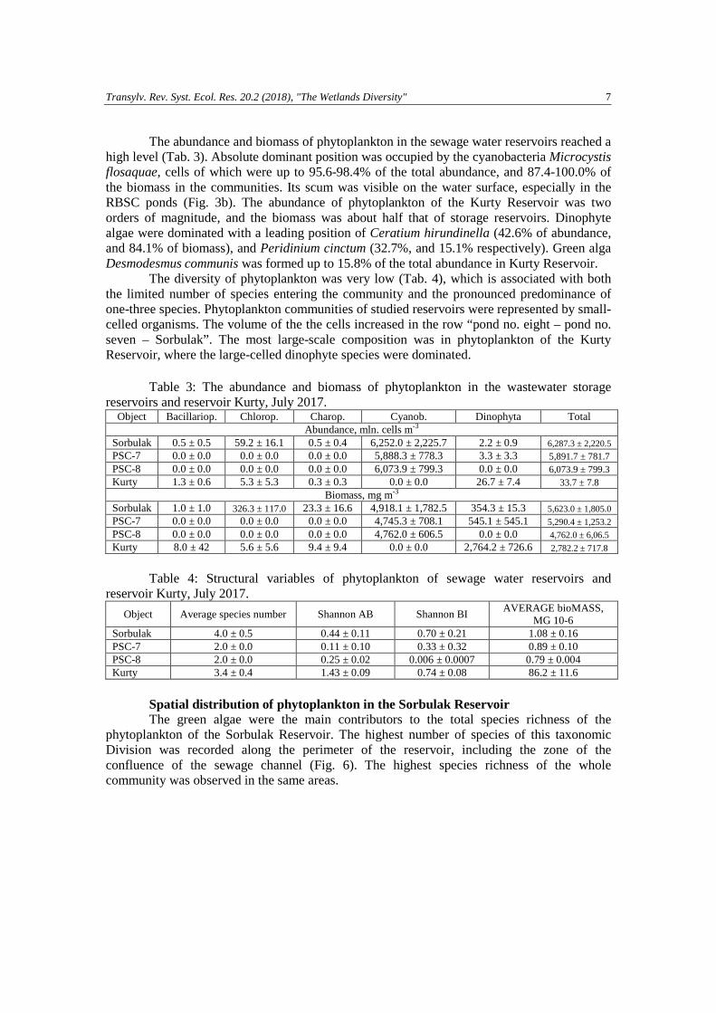
The abundance and biomass of phytoplankton in the sewage water reservoirs reached a high level (Tab. 3). Absolute dominant position was occupied by the cyanobacteria Microcystis flosaquae, cells of which were up to 95.6-98.4% of the total abundance, and 87.4-100.0% of the biomass in the communities. Its scum was visible on the water surface, especially in the RBSC ponds (Fig. 3b). The abundance of phytoplankton of the Kurty Reservoir was two orders of magnitude, and the biomass was about half that of storage reservoirs. Dinophyte algae were dominated with a leading position of Ceratium hirundinella (42.6% of abundance, and 84.1% of biomass), and Peridinium cinctum (32.7%, and 15.1% respectively). Green alga Desmodesmus communis was formed up to 15.8% of the total abundance in Kurty Reservoir. The diversity of phytoplankton was very low (Tab. 4), which is associated with both the limited number of species entering the community and the pronounced predominance of one-three species. Phytoplankton communities of studied reservoirs were represented by small-celled organisms. The volume of the the cells increased in the row “pond no. eight – pond no. seven – Sorbulak”. The most large-scale composition was in phytoplankton of the Kurty Reservoir, where the large-celled dinophyte species were dominated. Table 3: The abundance and biomass of phytoplankton in the wastewater storage reservoirs and reservoir Kurty, July 2017.
Object Bacillariop. Chlorop. Charop. Cyanob. Dinophyta Total Abundance, mln. cells m-3
Sorbulak 0.5 ± 0.5 59.2 ± 16.1 0.5 ± 0.4 6,252.0 ± 2,225.7 2.2 ± 0.9 6,287.3 ± 2,220.5 PSC-7 0.0 ± 0.0 0.0 ± 0.0 0.0 ± 0.0 5,888.3 ± 778.3 3.3 ± 3.3 5,891.7 ± 781.7 PSC-8 0.0 ± 0.0 0.0 ± 0.0 0.0 ± 0.0 6,073.9 ± 799.3 0.0 ± 0.0 6,073.9 ± 799.3 Kurty 1.3 ± 0.6 5.3 ± 5.3 0.3 ± 0.3 0.0 ± 0.0 26.7 ± 7.4 33.7 ± 7.8
Biomass, mg m-3 Sorbulak 1.0 ± 1.0 326.3 ± 117.0 23.3 ± 16.6 4,918.1 ± 1,782.5 354.3 ± 15.3 5,623.0 ± 1,805.0 PSC-7 0.0 ± 0.0 0.0 ± 0.0 0.0 ± 0.0 4,745.3 ± 708.1 545.1 ± 545.1 5,290.4 ± 1,253.2 PSC-8 0.0 ± 0.0 0.0 ± 0.0 0.0 ± 0.0 4,762.0 ± 606.5 0.0 ± 0.0 4,762.0 ± 6,06.5 Kurty 8.0 ± 42 5.6 ± 5.6 9.4 ± 9.4 0.0 ± 0.0 2,764.2 ± 726.6 2,782.2 ± 717.8
Table 4: Structural variables of phytoplankton of sewage water reservoirs and reservoir Kurty, July 2017.
Object Average species number Shannon AB Shannon BI AVERAGE bioMASS, MG 10-6
Sorbulak 4.0 ± 0.5 0.44 ± 0.11 0.70 ± 0.21 1.08 ± 0.16 PSC-7 2.0 ± 0.0 0.11 ± 0.10 0.33 ± 0.32 0.89 ± 0.10 PSC-8 2.0 ± 0.0 0.25 ± 0.02 0.006 ± 0.0007 0.79 ± 0.004 Kurty 3.4 ± 0.4 1.43 ± 0.09 0.74 ± 0.08 86.2 ± 11.6
Spatial distribution of phytoplankton in the Sorbulak Reservoir The green algae were the main contributors to the total species richness of the phytoplankton of the Sorbulak Reservoir. The highest number of species of this taxonomic Division was recorded along the perimeter of the reservoir, including the zone of the confluence of the sewage channel (Fig. 6). The highest species richness of the whole community was observed in the same areas.
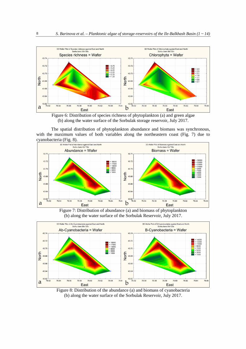
S. Barinova et al. – Planktonic algae of storage-reservoirs of the Ile-Balkhash Basin (1 ~ 14) 8
Figure 6: Distribution of species richness of phytoplankton (a) and green algae
(b) along the water surface of the Sorbulak storage reservoir, July 2017.
The spatial distribution of phytoplankton abundance and biomass was synchronous, with the maximum values of both variables along the northeastern coast (Fig. 7) due to cyanobacteria (Fig. 8).
Figure 7: Distribution of abundance (a) and biomass of phytoplankton
(b) along the water surface of the Sorbulak Reservoir, July 2017.
Figure 8: Distribution of the abundance (a) and biomass of cyanobacteria (b) along the water surface of the Sorbulak Reservoir, July 2017.

Transylv. Rev. Syst. Ecol. Res. 20.2 (2018), "The Wetlands Diversity" 9
The accumulations of green algae were recorded in the zone of influence of the sewage channel, in the eastern coastal strip, and also in the northern part of the reservoir (Fig. 9).
Figure 9: Distribution of abundance (a) and biomass of green algae (b) along the water surface
of the Sorbulak Reservoir, July 2017.
Statistical analysis of the data did not revealed influence of external factors on the structural variables of the phytoplankton of the Sorbulak Reservoir. Species richness (number of species) and species diversity (Shannon Ab and Shannon Bi) of phytoplankton communities increased due to green and, to a lesser extent, dinophyte algae (Tab. 5). Enrichment of communities with green and dinophyte algae led to an increase in the average cell size and an increase in the values of Shannon Bi. The values of the Shannon Ab index grew less with the enrichments of algae species in communities. A very strong statistically significant positive relationship was found between the average cell mass and W-Clarke values. Similar in strength and direction, statistically significant relationships within phytoplankton communities were also revealed when data on ponds RBSC no. seven, and RBSC no. eight were included in the analysis.
Table 5: Spearman correlation coefficients (R) between structural variables of phytoplankton of Sorbulak Reservoir, p < 0.05. Pair of variables R Pair of variables R Chlorophyta Ab – Species Number 0.830 Dinophyta Ab – Average Biomass 0.778 Chlorophyta Ab – Shannon Ab 0.875 Shannon Ab – Average Biomass 0.685 Chlorophyta Ab – Shannon Bi 0.912 Shannon Ab – W-Clarke 0.673 Chlorophyta Ab – Average Biomass 0.790 Shannon Bi – Average Biomass 0.939 Chlorophyta Ab – W-Clarke 0.784 Shannon Bi – W-Clarke 0.891 Dinophyta Ab – Species Number 0.740 W-Clarke – Average Biomass 0.939 Dinophyta Ab – Shannon Bi 0.727
Canonical Correspondence Analysis for divisional abundance and chemical variables were done on the base of tables 1 and 2 data for Sorbulak and Kurty reservoirs (Fig. 10).

S. Barinova et al. – Planktonic algae of storage-reservoirs of the Ile-Balkhash Basin (1 ~ 14) 10
Figure 10: CCA biplots for algal community abundance in the Sorbulak (a) and Kurty (b) reservoirs in July 2017.
The CCA plot for the Sorbulak community show that only two water variables, Cr and organic matter, demonstrate important influence for algal abundance (Fig. 10a). Whereas cyanobacteria was indifferent to chemical variables, other algal groups were favoured with nutrients (as Nitrates) input and slightly suppressed by the presence of chromium. The relationship of algal abundance and water variables in the Kurty Reservoir is not clear. The CCA biplot (Fig. 10b) show no significant difference for water variables influence to algal community. We can see that Mn, Cu, water temperatures, and phosphates slightly stimulated the development of diatoms and green algae. Opposite of these variables are Zn, Ni, Nitrites, Fe, Cr, and reservoir depth. This distribution can reflect the water mass uniformity and the upper water surface layer favourable for the algal community development. DISCUSSION Sewage storage reservoirs are model reservoirs for studying the effects of mixed pollution (organic in combination with toxic) on aquatic communities. In the summer of 2017 the reservoirs of the Right-Bank Sorbulak Canal were characterized mainly by organic pollution. This was evidenced by the high values of BOD, nitrogen compounds and phosphates (Tab. 1). The content of heavy metals in the water of all the studied water bodies was low. The total concentration of Zn, Cu, Cd, and Pb in the Sorbulak Reservoir decreased from 0.064-0.116 mg dm-3 in 2000-2002 to 0.025 mg dm-3 in 2017; in the pond of PSC no. eight it fell from 0.068 to 0.022 mg dm-3. This is mainly due to a reduction in the share of industrial effluents in the total volume of wastewater in recent decades (Dostai and Tyumenev, 2009). The Kurty Reservoir does not accept wastewater. However, the total content of heavy metals in the water of the Kurty Reservoir also decreased from 0.068 mg dm-3 in 2000 to 0.022 mg dm-3 in 2017. Thus, the change in the ecological situation in the studied sewage reservoirs and the Kurty Reservoir was synchronous. It can indicate the presence of additional sources of toxic pollution common to all studied water bodies in the region. This may be an underground runoff polluted by sewage, although its contribution to the contamination of the Kurty Reservoir is considered negligible (Dostai and Tyumenev, 2009), and also surface runoff from the catchment areas.

Transylv. Rev. Syst. Ecol. Res. 20.2 (2018), "The Wetlands Diversity" 11
One of the reasons for the low concentrations of heavy metals in Sorbulak and PSC ponds can be a high abundance of plankton algae. Under favorable trophic conditions, the biomass of phytoplankton communities in the reservoirs reached an average of 4,762.0-5,623.0 mg dm-3. As is known, algae have the ability to remove and accumulate metals in the following order: Zn > Cd > Ni > Cu > Cr (Shehata et al., 1999). Several species of green algae have effectively removed Zn from water at concentrations up to 5-20 mg dm-3 (Bácsi et al., 2015; Novák et al., 2015). Zn concentrations of more than 0.25 mg dm-3 are inhibiting the growth of the green alga Cladophora (De-ju et al., 2015). Lower concentrations of Zn are stimulating the growth of Cladophora. The effect of Cu on phytoplanktonic assemblage is stronger than Zn, although the intracellular accumulation of Zn is higher than Cu (Pandey et al., 2015). The sensitivity of periphytonic algae to Cu is decreased with an increase in phosphate concentrations in water (Serra et al., 2010) that we can recognize in the investigated reservoirs in 2017. The blue-green algae dominated the Sorboulak phytoplankton and the PSC ponds. Green algae were subdominants in Sorbulak communities. Diatoms were presented only in Sorbulak, but their numbers were low. As is known, blue-green algae are the most tolerant to heavy metals (Shehata et al., 1999). On the second place of sensitivity there are green algae. The most sensitive group to heavy metals is diatoms. Correlation analysis did not reveal impact of environmental factors, even heavy metals, on the structure of phytoplankton communities in the studied wastewater storage reservoirs. According to the results of CCA analysis, only Cr and nitrates had some effect on the abundance of algae. Whereas cyanobacteria were indifferent to the chemical variables, other algal groups were favoured with nitrates, and slightly suppressed by the presence of chromium. In Sorbulak and RBSC ponds, the chromium content (0.006-0.007 mg dm-3) was at a lower level than zinc (0.010-0.037 mg dm-3). The weak negative effect of chromium on algae is due to its higher toxicity, compared to zinc (Shehata et al., 1999; Kapkov, 2003). The phytoplankton abundance of the Kurty Reservoir was two orders of magnitude, and the biomass was two times lower than in the sewage reservoirs (Tab. 3). Unlike studied wastewater storages, in the phytoplankton of the Kurty Reservoir all founded algal taxonomic Divisions were represented, except for the blue-green ones. Dinophytes were dominated in abundance and biomass. The total content of nitrogen compounds in the water of the Kurty Reservoir (7.16 mg dm-3) was higher in storage reservoirs (0.72-6.16 mg dm-3). Obviously, the very low concentrations of phosphates were an unfavorable factor for algae of the Kurty Reservoir, an average of 0.0008 mg dm-3. This is four orders of magnitude smaller than in Sorbulak and RBSC ponds. The pronounced dominance of dinophyte algae may indicate an unfavorable ecological situation in the Kurty Reservoir. It has been shown that the composition of algal communities changes towards the predominance of species capable of heterotrophic nutrition under the conditions of toxic effect (Barinova et al, 2010a, 2010b, 2015). Such species are usually flagellate algae from the dinophyte Division. Under normal conditions, dinophytes are fed by chlorophyll. In toxic effects, the species of this Division switch to direct food with dissolved organic matter. The reasons for the suppression of photosynthesis may be different, from lack of light energy, to increased concentrations of nutrients or heavy metals but in any case the protein photosynthesis can be impacted.

S. Barinova et al. – Planktonic algae of storage-reservoirs of the Ile-Balkhash Basin (1 ~ 14) 12
The values of the Shannon Ab and Shannon Bi index were very low and have a positive correlation with the average individual cell mass. We have previously shown that, between Shannon Bi and the average mass of the algal cell, the correlation can be both negative (Barinova and Chekryzheva, 2014; Krupa et al., 2016), and positive (Krupa and Barinova, 2017). Analysis of large data sets showed that a positive relationship between diversity and organism body size is reflected in the relatively early stage of succession of plankton communities (Krupa and Barinova, 2017). Aquatic communities are enriched with small-size species with further eutrophication of reservoirs, and the relationship between diversity and cell-size becomes negative. The obtained results once again confirmed the nonlinearity of changes in the structural indicators of planktonic communities in the gradient of nutrient loading and eutrophication of aquatic ecosystems that we identified here and earlier.
CONCLUSIONS Sorbulak and associated ponds of RBSC are one of the world’s largest systems of biological wastewater treatment water reservoirs, with a total capacity of about 1,000 million m3. The Kurty Reservoir is located in the immediate vicinity of the Sorbulak Reservoir, but the sewage is not discharged into it. All the water bodies surveyed were characterized mainly by organic pollution in the summer of 2017. The content of heavy metals in the water was low. The synchronous decrease in the content of heavy metals in the water of all reservoirs from 2000 to 2017 can be recognized. It is assumed that a potential source of contamination of the Kurty Reservoir may be poluted underground runoff formed in the Sorbulak reservoir zone. Species richness and species diversity of phytoplankton communities of all studied water bodies were at a low level. Phytoplankton communities of wastewater reservoir facilities were represented mainly by species tolerant to organic and toxic pollution. Blue-greenalgae dominated reservoirs. The pronounced dominance of dinophyte algae may indicate an unfavorable ecological situation in the Kurty Reservoir. The significant effect of external factors on the structural variables of phytoplankton in reservoirs by means of correlation analysis has not been revealed. According to the results of CCA analysis, only Cr and nutrients had a significant effect on the abundance of algae. A positive statistically significant relationship between the Shannon index and the average algal cell mass was established. The obtained results once again confirmed the nonlinearity of changes in the structural indicators of plankton communities in the gradient of nutrient loading and eutrophication of aquatic ecosystems that we revealed earlier. These results can be developed in future investigations of this important system of purification water object in the region.
ACKNOWLEDGEMENTS The work was carried out under the project no. 1846/ГФ4 Г.2015-Г2016 for Committee of Science, Ministry of Education and Science, Republic of Kazakhstan “Development of the methods for controlling the ecological state of water bodies in Kazakhstan” as well as partly supported by the Israeli Ministry of Absorption.

Transylv. Rev. Syst. Ecol. Res. 20.2 (2018), "The Wetlands Diversity" 13
REFERENCES 1. Auezov E. M., Khrokov V. V. and Erokhov S. N., 1980 – The Sorbulak reservoir is a new
nesting, molting and wintering place for waterfowl and water birds in the southeast of Kazakhstan, in Economic activity and hunting fauna, V.1., Kirov, Russia, 48-49. (in Russian)
2. Barinova S. and Chekryzheva T., 2014 – Phytoplankton dynamic and bioindication in the Kondopoga Bay, lake Onego (Northern Russia), Journal of Limnology, 73, 2, 282-297, DOI: 10.4081/jlimnol.2014.820
3. Barinova S. and Krupa E., 2017 – Bioindication of ecological state and water quality by phytoplankton in the Shardara Reservoir, Kazakhstan, Environment and Ecology Research, 5, 2, 73-92, DOI: 10.13189/eer.2017.050201.
4. Barinova S. S., Bragina T. M. and Nevo E., 2009 – Algal species diversity of arid region lakes in Kazakhstan and Israel, Community Ecology, 10, 1, 7-16, DOI 10.1556/ComEc.10.2009.1.2.
5. Barinova S. S., Klochenko P. D. and Belous Y. P., 2015 – Algae as indicators of the ecological state of water bodies: methods and prospects, Hydrobiological Journal, 51, 6, 3-21, DOI: 10.1615/HydrobJ.v51.i6; 51, 45, 3-23.
6. Barinova S. S., Tavassi M. and Nevo E., 2010a – Algal communities of the Hadera River (Israel) under dramatic niche changes, Central European Journal of Biology, 5, 4, 507-521, DOI 10.2478/s11535-010-0033-1.
7. Barinova S., Tavassi M., Glassman H. and Nevo E., 2010b – Algal indication of pollution in the lower Jordan River, Israel, Applied Ecology and Environmental Research, 8, 1, 19-38.
8. Bácsi I., Novák Z., Jánószky M., B-Béres V., Grigorszky I. and Nagy S. A., 2015 – The sensitivity of two Monoraphidium species to zinc: their possible future role in bioremediation, International Journal of Environmental Science and Technology, 12, 2455-2466, DOI 10.1007/s13762-014-0647-3.
9. De-ju C., Pan-pan X., Juan-wei D., Hui-min Z., Ru-xiao M., Cheng L., Ren-jing L., Yue-gan L., Hao L. and Xiao-dong S., 2015 – Effects of Cu2+ and Zn2+ on growth and physiological characteristics of green algae, Cladophora, Environmental Science and Pollution Research, 22, 16535-16541, DOI 10.1007/s11356-015-4847-2.
10. Dostai Z. D. and Tyumenev S. D., 2009 – Water supply and sanitation management in Almaty, Almaty, Kazakhstan, Euro Print, 176. (in Russian)
11. Fomin G. S., 1995 – Water. Control of chemical, bacterial and radiation safety according to international standards, Moscow, Russia, NGO “Alternative”, 618. (in Russian)
12. Kapkov V. I., 2003 – Algae as biomarkers of contamination by heavy metals of marine coastal ecosystems, The abstract of the dissertation of the Doctor of biological sciences, Moscow, Russia, Moscow State University, 43. (in Russian)
13. Krupa E. G. and Barinova S. S., 2017 – Use of structural indicators of hydrocenoses in the assessment of the ecological state of water bodies in Kazakhstan, in Proceedings of III International Conference “Bioindication in monitoring of freshwater ecosystems”, St. Petersburg, INOG RAS, 165-170. (in Russian)
14. Krupa E. G., Barinova S. S., Romanova S. M. and Malybekov A. B., 2016 – Hydrobiological assessment of the high mountain Kolsay lakes (Kungey Alatau, Southeastern Kazakhstan) ecosystems in climatic gradient, British Journal of Environment and Climate Change, 6, 4, 259-278, DOI: 10.9734/BJECC/2016/26496.
15. Matmuratov S. A., Bragin B. I., Troshina T. T. and Krupa E. G., 1999 – Features of the formation of the ecological-toxicological situation in the discharge zone of the Sorbulak Canal in the Ili River, in Problems of protection and sustainable use of biodiversity of wildlife of Kazakhstan, Almaty, Kazakhstan, Institute of Zoology, 132-133. (in Russian)
16. Momeu L., Peterfi L. Ș. and Blaga L., 2012 – Planktonic algal communities occurring in the wetlands of the Cefa Nature Park (Crișana, Romania), Transylvanian Review of Systematical and Ecological Research, 13, The Cefa Nature Park, 11-34.

S. Barinova et al. – Planktonic algae of storage-reservoirs of the Ile-Balkhash Basin (1 ~ 14) 14
17. Novák Z., Jánószky M., Béres V., Nagy S. A. and Bácsi I., 2014 – Zinc tolerance and zinc removal ability of living and dried biomass of Desmodesmus communis, Bulletin of Environmental Contamination and Toxicology, 93, 676-682, DOI 10.1007/s00128-014-1374-7.
18. Pandey L. K., Han T. and Gaur J. P., 2015 – Response of a phytoplanktonic assemblage to copper and zinc enrichment in microcosm, Ecotoxicology, 24, 573-582, DOI 10.1007/s10646-014-1405-5.
19. Poikane S., Berg M., Hellsten S., Hoyos C., Ortiz-Casas J., Pall K., Portielje R., Phillips G., Lyche Solheim A., Tierney D., Wolfram G. and Bund W., 2011 – Lake ecological assessment systems and intercalibration for the European Water Framework Directive: aims, achievements and further challenges, Procedia Environmental Sciences, 9, 153-168.
20. Poikane S., Birk S., Böhmer J., Carvalho L., Hoyos C., Gassner H., Hellsten S., Kelly M., Solheim A L, Olin M., Pall K., Phillips G., Portielje R., Ritterbusch D., Sandin L., Schartau A.-K., Solimini A. G., Berg M., Wolfram G. and Bund W., 2015 – A hitchhiker’s guide to European lake ecological assessment and intercalibration, Ecological indicators, 52, 533-544.
21. Semenova A. D. (ed.), 1977 – Guideline for chemical analysis of surface water, Leningrad, Russia, Gidrometeoizdat, 541. (in Russian)
22. Serra A., Guasch H., Admiraal W., Van der Geest H. G. and Van Beusekom S. A. M., 2010 – Influence of phosphorus on copper sensitivity of fluvial periphyton: the role of chemical, physiological and community-related factors, Ecotoxicology, 19, 770-780, DOI 10.1007/s10646-009-0454-7.
23. Shehata S. A., Lasheen M. R., Kobbia I. and Ali G. H., 1999 – Toxic effect of certain metals mixture on some physiological and morphological characteristics of freshwater algae, Water, Air, and Soil Pollution, 110, 119-135.
24. Stevenson J., 2014 – Ecological assessments with algae: a review and synthesis, Journal of Phycology, 50, 437-461, doi:10.1111/jpy.12.

Transylv. Rev. Syst. Ecol. Res. 20.2 (2018), "The Wetlands Diversity" 15
AMBOPHILY IN THE DIOECIOUS WEEDY MANGROVE ASSOCIATE, EXCOECARIA AGALLOCHA (EUPHORBIACEAE)
Henry Jonathan KARAMSETTY * and Jacob Solomon Raju ALURI *
* Andhra University, Department of Environmental Sciences, Visakhapatnam, China Waltair Street, India, IN-530 003, [email protected], [email protected]
DOI: 10.2478/trser-2018-0009
KEYWORDS: Dioecy, ambophily, mangrove associate.
ABSTRACT Excoecaria agallocha is a deciduous tree species dispersed as mangrove associate in oligohaline to polyhaline areas of the mangrove forest. The existence of male and female tree ratio is 2:1. The ratio of male to female flowers is 16:1. It is an constrained out-crosser and is pollinated by insects like bees, flies, butterflies, and wind, which constitute ambophily. Anemophily make certain the realization of sexual reproduction if the insect pollinators are nor present and such a breeding system is a “fail-safe” strategy for reproductive assurance during colonization. Natural fruit set rate is 92%. Fruit predation by Chrysocoris partricius is 25%; it consumes the fruits prior to their fall from the mother plant. This tree species occupies the cleared or open areas within the mangrove forest and acts as an invasive mangrove associate.
RÉSUMÉ: L’Ambophilie chez l’espèce rudérale décidue associée aux mangroves Excoecaria agallocha (Euphorbiaceae). Excoecaria agallocha est une espèce d’arbre associée aux zones oligohalines jusqu’aux zones polyhalines des forêts des mangroves. C’est une espèce décidue avec un taux d’occurrence d’arbre mâle-arbre femelle de 2:1. Le rapport des fleurs mâles et des fleurs femelles est de 16:1. L’espèce se reproduit par pollinisation croisée systématique, étant pollinisée par des insectes comme les abeilles, mouches et papillons mais aussi par le vent, ce qui la rend ambophile. L’anémophilie assure le succès reproducteur dans l’absence des insectes pollinisateurs, un tel système reproductif étant une stratégie “sûre à 100%” assurant la reproduction durant l’étape de colonisation. Le taux de fructification est de 92%. La prédation des fruits par Chrysocoris partricius est de 25%; le dernier consomme les fruits avant que celles-ci tombent de la plante mère. Cet espèce d’arbre occupe les zones ouvertes et défrichées de la forêt des mangroves et se comporte en tant qu’associé invasif des mangroves.
REZUMAT: Ambofilie la specia ruderală deciduă asociată mangrovetumurilor, Excoecaria agallocha (Euphorbiaceae). Excoecaria agallocha este o specie de arbore întâlnită în asociații din zonele oligohaline până la polihaline ale pădurilor de mangrove. Este o specie deciduă, cu un raport de prezență arbore mascul la arbore femel de 2:1. Raportul de flori mascule la femele este de 16:1. Specia necesită obligatoriu polenizare încrucișată, realizată prin intermediul insectelor, precum albine, muște și fluturi, care, împreună cu vântul, conferă caracterul ambofil al speciei. Anemofilia asigură succesul reproducerii sexuate în absența insectelor polenizatoare, un astfel de sistem reproducător furnizând o strategie „sigură 100%” în timpul colonizării de noi spații. Rata naturală de fructificare este de 92%. Prădătorismul fructelor de către Chrysocoris partricius este de 25%; specia consuma fructele înainte de desprinderea lor de planta mamă. Această specie de arbore ocupă zonele deschise sau defrișate din pădurile de mangrove și acționează ca un asociat invaziv al mangrovelor.
H. J. Karamsetty and J. S. R. Aluri – Ambophily in mangrove associate Excoecaria agallocha (15 ~ 28) 16
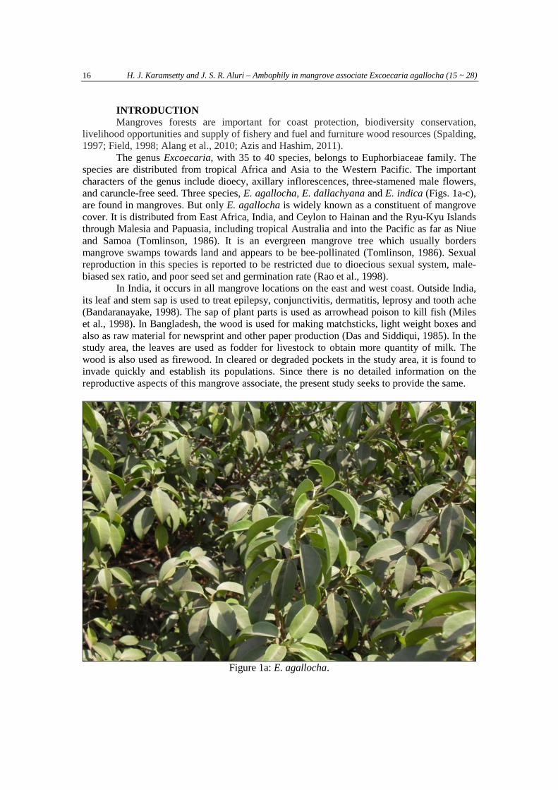
INTRODUCTION Mangroves forests are important for coast protection, biodiversity conservation, livelihood opportunities and supply of fishery and fuel and furniture wood resources (Spalding, 1997; Field, 1998; Alang et al., 2010; Azis and Hashim, 2011). The genus Excoecaria, with 35 to 40 species, belongs to Euphorbiaceae family. The species are distributed from tropical Africa and Asia to the Western Pacific. The important characters of the genus include dioecy, axillary inflorescences, three-stamened male flowers, and caruncle-free seed. Three species, E. agallocha, E. dallachyana and E. indica (Figs. 1a-c), are found in mangroves. But only E. agallocha is widely known as a constituent of mangrove cover. It is distributed from East Africa, India, and Ceylon to Hainan and the Ryu-Kyu Islands through Malesia and Papuasia, including tropical Australia and into the Pacific as far as Niue and Samoa (Tomlinson, 1986). It is an evergreen mangrove tree which usually borders mangrove swamps towards land and appears to be bee-pollinated (Tomlinson, 1986). Sexual reproduction in this species is reported to be restricted due to dioecious sexual system, male-biased sex ratio, and poor seed set and germination rate (Rao et al., 1998). In India, it occurs in all mangrove locations on the east and west coast. Outside India, its leaf and stem sap is used to treat epilepsy, conjunctivitis, dermatitis, leprosy and tooth ache (Bandaranayake, 1998). The sap of plant parts is used as arrowhead poison to kill fish (Miles et al., 1998). In Bangladesh, the wood is used for making matchsticks, light weight boxes and also as raw material for newsprint and other paper production (Das and Siddiqui, 1985). In the study area, the leaves are used as fodder for livestock to obtain more quantity of milk. The wood is also used as firewood. In cleared or degraded pockets in the study area, it is found to invade quickly and establish its populations. Since there is no detailed information on the reproductive aspects of this mangrove associate, the present study seeks to provide the same.
Figure 1a: E. agallocha.

Transylv. Rev. Syst. Ecol. Res. 20.2 (2018), "The Wetlands Diversity" 17
Figure 1b: Excecaria dallachyana.
Figure 1c: Excoecaria indica.

H. J. Karamsetty and J. S. R. Aluri – Ambophily in mangrove associate Excoecaria agallocha (15 ~ 28) 18
MATERIAL AND METHODS Excoecaria agallocha distributed in the Godavari mangrove wetland in the State of Andhra Pradesh, India was used for the study during 2014-2015. It is a common mangrove associate and grows naturally from oligo to poly-haline areas within the mangrove forest. It is common towards land side, but extends and expands its occurrence as a weed in cut or open areas throughout the mangrove forest. Since the plant is dioecious, surveys were made to calculate the ratio of male and female trees growing in this area. Floral structural and functional aspects such as anthesis, anther dehiscence, flowering phenology, flower morphology, pollen production, pollen-ovule ratio, nectar production, stigma receptivity, breeding system, natural fruit set, seed set, foraging activity of insects, and pollen carrying rate were investigated in detail as per the protocols provided in Dafni et al. (2005). Further, anemophily occurrence and seed dispersal strategies were examined in the field itself. RESULTS Phenology. Phenology. It is a semi-deciduous tree with spreading branches (Fig. 1a). Young twigs and mature trunk base present lenticels. The aerial parts leak out white latex when wounded. Individual trees bear either male or female flowers but not both. Male and female trees occur in the ratio of 2:1 and both flower simultaneously during June-August. In male trees, the inflorescence is pendulous catkin and born in axillary position (Figs. 1b-d) while in female trees, the inflorescence represents an erect mixed cyme which is also borne in axillary position. In male trees, the inflorescences produce a mean number of 195 flowers over a period of five or six days. In female trees, the inflorescences produce an average of 12 flowers over a period of four or five days. The Flower. Male flowers are bracteate, sessile, odourless, very small, and zygomorphic. Sepals are three, light green, valvate and persistent (Fig. 1e). Stamens are three, free, small, fertile; filament is light yellow, 10 mm long and glabrous, anther bi-locular, basifixed to almost versatile, extrorse, round, yellow, one mm long (Fig. 1f). Pistillode is absent.
Female flowers are bracteate, bracts glandular, sessile, odourless, ovoid and zygomorphic. Sepals are three, glabrous, green, valvate and wider than those in male flowers. Staminodes are absent. Ovary is syncarpous, superior with three carpels and three locules; each locule consists of a single basal ovule. The ovary consists of three short, spreading and recurved simple two mm long styles. Floral biology. The male and female mature buds open at 06.00-09.00 hrs and anthesis in the inflorescences of both the sexes is acropetal. In male flowers, sepals unfold gradually in a time span of about 30 minutes. Then, stamens are exposed and anthers are quite prominent to the naked eye. Another dehiscence occurs about 30 minutes after anthesis by longitudinal slits. The pollen output per anther is 2,201 ± 205.4 (Range 1,938-2,572) and per flower is 6,603 pollen grains. Pollen grains are powdery, ptychotreme, tricolporate, dark yellow, exine thick, and 33.2 µm in size. The pollen-ovule ratio is 35,259.4:1. The pollen protein content per anther is three µg and per flower is nine µg. Nectar is present in traces only. Flowered male inflorescences hang downwards and gradually wither away. In female flowers, sepals, being inconspicuous, do not enclose the ovary and styles. The closely spaced erect styles reflex downward exposing their upper surface; this position was considered as the period of anthesis and commencement of receptivity to pollen grains. Further, the period of receptivity was confirmed by hydrogen peroxide test. The receptivity remains until the afternoon of the 2nd day and the styles remain in place even after fruit maturation. A female flower produces 0.81 ± 0.2 (Range 0.5-1.2) µl of nectar.

Transylv. Rev. Syst. Ecol. Res. 20.2 (2018), "The Wetlands Diversity" 19
Figure 1: Excoecaria agallocha: a. Habitat; b. Male catkin; c. Flowering male catkin; d. Young male catkin; e. Male flower; f. Anthers; g. Female catkin; h. Female flower; i. Fruit set in open pollinations; j. Single fruit; k. Chrysocoris patricius feeding on mature fruits; l. C. patricius-damaged fruits; m. Wind-driven pollen fall on leaves; n. Chrysomya megacephala collecting
forage from male flowers; o. C. megacephala sucking sap from the stem.

H. J. Karamsetty and J. S. R. Aluri – Ambophily in mangrove associate Excoecaria agallocha (15 ~ 28) 20
Breeding systems. As male and female trees are different, the sexual system represents dioecy. Pollen flow from male to female trees occurs only with the assistance of external agents which include wind and insects. Pollen release from male trees due to the action of wind was observed as shown in figure 1m. Pollination mechanism and Pollinators. Male flowers were foraged during daytime from 06.00-17.00 hrs by different insects. The insects recorded on male catkins were bees (Apis dorsata – figure 2b, A. cerana, A. florea – figure 2d, Nomia sp. – figure 2e, Xylocopa sp., X. pubescens and X. latipes), flies (Chrysomya megacephala – figure 1n and Eristalinus arvorum – figure 2a) and butterflies (Acraea violae – plate 21i, Danaus chrysippus – figure 2f, D. genutia, Hypolimnas bolina – figure 2j, Junonia almana – figure 2g, J. lemonias – figure 2h, Tirumala limniace – figure 2k, and Cynthia cardui – figure 2l) (Figs. 3-5). All the bee species were found to collect pollen and nectar while flies and butterflies gathered nectar only. While collecting pollen and/or nectar, bees and flies got dusted with pollen on their ventral side. In case of butterflies, while collecting nectar, their proboscis, head, and abdomen touched the anthers, and in the process, these parts were coated with pollen. Body washings of these insects revealed the presence of pollen grains. The average number of pollen grains is 333.9-1,107.5 for bees, 98-398 for flies, and 36.2-100 for butterflies (Tab. 1). The hourly foraging activity of each category of insects was found to vary with the time of day. Bees and flies consistently collected the forage with varying numbers of visits at each hour, while butterflies confined their nectar collection to 07.00-12.00 hrs with varying numbers of visits at each hour during this period. Of the total number of foraging visits, A. dorsata made 27% and C. megacephala 26.3% of visits while other species, each made visits ranging from 0.8 to 8.2% (Fig. 6). The female flowers were foraged by insects during 06.00-14.00 hrs (Fig. 7). The insects recorded on female trees included the same insect species which were found on male trees; the bees A. cerana, Xylocopa species and butterflies, Tirumala limniace and Cynthia cardui however, were not found. All these insect species collected nectar only as the flowers are devoid of stamens. A. dorsata (Fig. 2c) and butterflies began foraging activity from 06.00 h while all other insects from 07.00 h, and all ceased their nectar collection by 12.00/13.00 hrs. These insect species, individually, made 7.5 to 12% of foraging visits (Fig. 8). While collecting nectar, the underside of their body invariably contacted the styles and the pollen carried by them was transferred to the upper surface of the styles. The pollen deposition rate was more at 09.00-10.00 hrs (Fig. 9). The styles in virgin female flowers when exposed by removing bags during 14.00-17.00 hrs were found with pollen grains; the number ranged from 25-57. The deposition of pollen grains during this period was considered to be a result of pollen transfer by wind action. C. megacephala also feeds on the sap of stems of both male and female trees (Fig. 10).

Transylv. Rev. Syst. Ecol. Res. 20.2 (2018), "The Wetlands Diversity" 21
Figure 2: Excoecaria agallocha – Flower visitors a, b, d-l on male catkins and c on female
catkin: a. Eristalinus arvorum; b. and c. Apis dorsata; d. Apis florea; e. Nomia sp.; f. Danaus chrysippus; g. Junonia almana; h. Junonia lemonias; i. Acraea violae;
j. Hypolimnas bolina; k. Tirumala limniace; l. Cynthia cardui.
Fruiting ecology. Fruit set is 92% in open-pollinations (Fig. 1i). A beetle species, Chrysocoris patricius voraciously fed on fruits and its percent stood at 25% (Figs. 1k, l). Fruits mature within 40 days. Individual fruits produce 3 seeds (Fig. 1j); they are leathery, 3-lobed with green to dark brown pericarp through maturation. Fruits dehisce explosively and disperse seeds. The seeds float in tidal water and eventually anchor in a suitable soil environment. The seeds fall to the ground and anchor in the soil within the parental sites if the soil is exposed at the time of fruit dehiscence. Table 2 presents sequential events of sexual reproduction in this plant.

H. J. Karamsetty and J. S. R. Aluri – Ambophily in mangrove associate Excoecaria agallocha (15 ~ 28) 22
Figure 3: Hourly foraging activity of bees on male trees of Excoecaria agallocha.
Figure 4: Hourly foraging activity of flies on male trees of Excoecaria agallocha.
Figure 5: Hourly foraging activity of butterflies on male trees of Excoecaria agallocha.

Transylv. Rev. Syst. Ecol. Res. 20.2 (2018), "The Wetlands Diversity" 23
Figure 6: Percentage of foraging visits of insects on male trees of Excoecaria agallocha.
Figure 7: Hourly foraging activity of insects on female trees of Excoecaria agallocha.
Figure 8: Percentage of foraging visits of insects on female trees of Excoecaria agallocha.

H. J. Karamsetty and J. S. R. Aluri – Ambophily in mangrove associate Excoecaria agallocha (15 ~ 28) 24
Figure 9: Pollen deposition rate on the styles
of Excoecaria agallocha.
Table 1: Pollen carrying capacity of insect foragers on male trees of Excoecaria agallocha.
Insect species Sample size Range Mean ± S.D. Apis dorsata 10 321-762 550.7 ± 155.62 A. cerana 10 215-423 392.7 ± 91.97 A. florea 10 240-423 333.9 ± 61.60 Nomia sp. 10 276-578 423.4 ± 114.38 Chrysomya megacephala 10 78-123 98 ± 10.5 Eristalinus arvorum 10 76-97 398 ± 64.06 Xylocopa latipes 10 819-1379 1107.5 ± 194.36 X. pubescens 10 912-1259 1030.7 ± 115.62 Xylocopa sp. 10 765-1074 898 ± 101.92 Acraea violae 10 54-68 61 ± 8.5 Danaus chrysippus 10 24-86 54 ± 9.5 D. genutia 10 43-67 50 ± 11.3 Hypolimnas bolina 10 76-121 98.4 ± 14.3 Junonia almana 10 85-116 100 ± 5.7 J. lemonias 10 23-54 36.2 ± 12.4 Tirumala limniace 10 43-65 53.3 ± 15.4 Cynthia cardui 10 45-67 56.2 ± 9.5

Transylv. Rev. Syst. Ecol. Res. 20.2 (2018), "The Wetlands Diversity" 25
Table 2: Chronological events of sexual reproduction in Excoecaria agallocha.
DISCUSSION Excoecaria agallocha grows from oligohaline to polyhaline zones in the mangrove forest. It is dioecious and flowers for about three months during the rainy season. The flowering is synchronous in both male and female trees. In the sampled sites, the ratio of male to female trees is 2.2:1, and the ratio of male to female flowers at inflorescence level is 16:1. Male flowers produce rich amount of protein-poor pollen while three-ovuled ovary is the characteristic of female flowers. Both the male and female flowers are small and lacking odour. The anthers in male flowers are free, exposed and versatile; the conditions of which facilitate the release of pollen into the air. Collectively, all of these characteristics suggest that the plant is adapted for anemophily, also, the pollen is released into the air due to wind action. However, there is also a lot of wastage of pollen during its travel from male to female flowers. In this context, wind-pollination is not economical, not reliable as pollen vector, and is energetically expensive for the plant.
Floral event Excoecaria agallocha Anthesis 06.00-09.00 hrs Anther dehiscence 30 minutes after anthesis Sepals Sepals are persistent Petals Absent Stamens Empty anthers and filaments remain in place for a long
time Style (s) Persistent Stigma Absent Stigma receptivity Styles receptive to pollen from anthesis to afternoon of
2nd day Pollen output/flower 6,603 Pollen protein/flower (µg/mg) nine µg Pollen-ovule ratio 35,259.4:1 Nectar volume/flower (µl) Male flowers – traces
Female flowers –0.8 ± 0.2 Pollination mechanism Unspecialized Pollinators Bees, flies and butterflies Breeding system Cross Bud abortion (%) Nil Fruit abortion (%) Nil Fruit set in open pollinations (%) 92% ‒ Fruit predation: 25% Fruit maturation time (days) 35-40 Fruit orientation Erect Seed output/fruit three Planting strategy Self-planting and stranding

H. J. Karamsetty and J. S. R. Aluri – Ambophily in mangrove associate Excoecaria agallocha (15 ~ 28) 26
In E. agallocha, the long catkins of male trees and the short mixed cymes of female trees display a number of flowers. The presence of several such inflorescences on each tree simultaneously is quite attractive to foragers. The yellow stamens and bright green shining styles may further enhance attractiveness to foragers. Both the flower sexes produce nectar; it is trace in male flowers while it is relatively measurable in female flowers. These characteristics indicate that the plant evolved for pollination by insects. The study also indicated that bees, flies, and butterflies visit both male and female flowers during daytime and pollinate the styles in female flowers. Body washings of these insects also indicated that they are pollen carriers and transfer pollen to styles of female flowers. The styles show receptivity also on the 2nd day, the characteristic of which facilitates pollination in case of failure of pollination on the day of anthesis. Therefore, the flower morphology and functional characteristics suggest that the plant is evolved for pollination by both wind and insects. In support of this, Tomlinson (1986) reveals that the plant may be bee-pollinated. The ability of the plant to utilize abiotic and biotic agents for fruit set is highly adaptive for the successful colonization of mangrove areas. Field observations also indicate that it is an invasive species and colonizes easily in cut or naked areas of mangroves by disallowing the growth and development of established seedlings of true viviparous and crypto-viviparous species. Rao et al. (1998) reported that in E. agallocha, the dioecious nature, the predominance of male trees over female trees, and its poor seed set and germination restrict its multiplication through sexual reproduction. On the contrary, the present study shows that this plant depicts more than 90% of fruit set and each fruit characteristically produces three seeds. But, fruit predation by a green beetle, Chrysocoris patricius, to an extent of 25% has been found to be responsible for reducing the success rate of sexual reproduction. Seeds lack dormancy and release explosively from the mature fruit capsules (Das and Ghose, 2003). The released seeds settle and produce new plants within the parental sites if the latter are exposed and, if not, seeds float in tidal water due to the presence of an air space within the seed coat and establish in different salinity zones of mangroves.
CONCLUSIONS Excoecaria agallocha is the only dioecious species in the mangrove forest. It is a highly successful mangrove associate due to its ability to occupy different salinity zones within the mangrove forest. It bears fruits through entomophily and anemophily and disperse seeds by self-planting and stranding strategies. With these abilities, it is able to invade the cleared or open areas and dominate the mangrove flora. A green beetle, Chrysocoris patricius is its natural control since it significantly reduced fruit set rate by fruit predation.

Transylv. Rev. Syst. Ecol. Res. 20.2 (2018), "The Wetlands Diversity" 27
ACKNOWLEDGEMENTS We thank the Andhra University, Visakhapatnam, for providing facilities to carry out the work presented in the paper. We also thank Venkata Ramana K., Department of Environmental Sciences, Andhra University, Visakhapatnam, for providing assistance during field work in Coringa Mangrove Forest.

H. J. Karamsetty and J. S. R. Aluri – Ambophily in mangrove associate Excoecaria agallocha (15 ~ 28) 28
REFERENCES 1. Alang R. N. N. R., Jusoh W. F. A. W., Nur-Zati A. M. and Hashim N. R. 2010 ‒ Ant diversity
on Sonneratia caseolaris trees in Rembau-Linggi mangrove forest, Peninsular Malaysia, Transylvanian Review of Systematical and Ecological Research, 10, The Wetlands Diversity, 77-82.
2. Azis T. N. A. and Hashim N. R., 2010 ‒ Heavy metal concentrations in an important mangrove palm (Nypa fruticans), in Rembau-Linggi Mangrove Forest (Peninsular Malaysia), Transylvanian Review of Systematical and Ecological Research, 12, The Wetlands Diversity, 111-116.
3. Bandaranayake W. M., 1998 ‒ Traditional and medicinal uses of mangroves, Mangroves and Salt Marshes, 2, 133-148.
4. Blasco F., Aizpuru M. and Gers C., 2001 ‒ Depletion of the mangroves of Continental Asia, Wetlands Ecology and Management, 9, 245-256.
5. Dafni A., Kevan P. G. and Husband B. C., 2005 ‒ Practical Pollination Biology, Enviroquest Ltd., Ontario, 590.
6. Das S. and Ghose M. 2003 ‒ Seed structure and germination pattern of some Indian mangroves with taxonomic relevance, Taiwania, 48, 287-298.
7. Das S. and Siddiqui N. A. 1985 ‒ The mangroves and mangrove forests of Bangladesh, UNDP/FAO Project BGD/79/017, Rome.
8. Field C. D., 1998 ‒ Rehabilitation of mangrove ecosystems: an overview, Marine Pollution Bulletin, 37, 383-392, doi:10.1016/s0025-326x(99)00106-x
9. Miles D. H., Kokpol U., Chittawong V., Tip-Pyang S., Tunsuwan K. and Nguyen C., 1998 ‒ Mangrove forests ‒ The importance of conservation as a bioresource for ecosystem diversity and utilization as a source of chemical constituents with potential medicinal and agricultural value, Pure and Applied Chemistry, 70, 1-9.
10. Rao C. S., Eganathan P., Anand A., Balakrishna P. and Reddy T. P., 1998 ‒ Protocol for in-vitro propagation of Excoecaria agallocha L., a medicinally important mangrove species, Plant Cell Reports, 17, 861-865.
11. Spalding M. D., 1997 ‒ The global distribution and status of mangrove ecosystems’, Mangrove Edition, International Newsletter of Coastal Management (Intercoast Network) Special Edition #1. Narragansett: Coastal Resources Center, University of Rhode Island, 20-21.
12. Tomlinson P. B., 1986 ‒ The Botany of Mangroves, Cambridge University Press, New York, 413.
13. Zhengyun Z., Zhixian S., Qiaoying Z. and Aiying S., 2003 ‒ The current status of world protection for mangrove forest, Chinese Journal of Oceanology and Limnology, 21, 261-269.

Transylv. Rev. Syst. Ecol. Res. 20.2 (2018), "The Wetlands Diversity" 29
MICROBIOLOGICAL LEACHING; AN ENVIRONMENTALLY FRIENDLY AND COST EFFECTIVE METHOD
FOR EXTRACTION OF METALS
Mehdi GHOBEITI-HASAB * and Zahra KHOSHNOOD **
* Department of Metallurgy and Materials, Faculty of Engineering, Dezful Branch, Islamic Azad University, Dezful, Iran, [email protected] ** Faculty of Science, Dezful Branch, Islamic Azad University, Dezful, Iran, [email protected]
DOI: 10.2478/trser-2018-0010 KEYWORDS: Bio-leaching, bio-oxidation, bacteria.
ABSTRACT Finding a cleaner, environmentally friendly and cost-effective way of metal and mineral extraction has a great importance in today’s world. Using microorganisms in bio-leaching and bio-oxidation process is of great value. From Archaea to bacteria and fungi, microorganisms can play an important role in extraction of metals from mine drainage and un-accessible sources, both in aquatic and terrestrial environments. Optimization of environmental factors such as the temperature, pH and substrate concentration is crucially important to access the optimum extraction of selected metals from an ore or mine drainage. The present paper will review the bio-leaching and bio-oxidation process of minerals with emphasis on the most well-known species of bacterial communities of such ability, through the literature.
RESUMEN: La lixiviation microbiologique; une méthode écologique et rentable pour l’extraction des métaux. Trouver une façon plus propre, respectueuse de l’environnement et économique de l’extraction des métaux et des minéraux est d’une grande importance dans le monde d’aujourd’hui. L’utilisation de microorganismes dans le processus de bio-lixiviation et de bio-oxydation est d’une grande valeur. De l’Archaea aux bactéries et aux champignons, les microorganismes peuvent jouer un rôle important dans l’extraction des métaux du drainage des mines et des sources non accessibles, tant dans les milieux aquatiques que terrestres. L’optimisation des facteurs environnementaux tels que la température, le pH et la concentration du substrat est cruciale pour accéder à l’extraction optimale des métaux sélectionnés à partir d’un minerai ou d’un drainage minier. Le présent document examinera le processus de bio-lixiviation et de bio-oxydation des minéraux, en mettant l’accent sur les espèces les plus connues de communautés bactériennes de cette capacité, à travers la littérature.
REZUMAT: Lixivierea microbiologică; o metodă ieftină și ecologică de extragere a metalelor. În contextul internațional actual, găsirea unei metode mai ecologice, mai puțin poluante și ieftine de extragere a metalelor și minereurilor este de mare importanță. O deosebită valoare este reprezentată de utilizarea microorganismelor în procese bio-oxidative și de bio-lixiviere. De la Archaea la bacterii și fungi, microorganismele pot juca un rol important în extragerea metalelor din apele de mină și din surse inaccesibile atât în mediu terestru cât și acvatic. Optimizarea factorilor ambientali precum temperatura, pH-ul și concentrația substratului sunt cruciale pentru o extragere optimă a metalelor selecționate din zăcământ sau din apele de mină. Articolul de față trece în revistă procesele de extragere a mineralelor prin bio-oxidare și bio-lixiviere, evidențiind cele mai bine cunoscute specii din comunitățile bacteriene cu astfel de abilități, așa cum sunt ele prezentate în literatura de specialitate.

M. Ghobeiti-Hasab and Z. Khoshnood – Microbiological leaching (29 ~ 38) 30
INTRODUCTION Excavation of mines for different minerals extraction is one of the most destructive anthropogenic activities for terrestrial and aquatic ecosystems. Such activities affect the topography, turbidity, concentration of dissolved particles and minerals, pH, etc. and could affect the life of inhabited organisms directly or indirectly (Ashton et al., 2001). Microorganisms are one of the most abundant living organisms of all ecosystems from terrestrial to aquatic habitats. Different classes of such organisms have biological, chemical, and physical effects on their surrounding environments. Using microorganisms for extraction of wide range of minerals and biological products is an effective and environmentally friendly way to use the new sources of minerals and metals which cannot be extracted using common and ordinary methods (Edwards et al., 2013). Using the microorganisms, especially the bacteria and fungi, is a clean way of extracting minerals and metals from the wastewater of industries as well. Thereby the process called bio-leaching, which means the dissolution of metals from their mineral source using microorganisms, or using microorganisms to transform elements of certain ore to a kind of soluble form which could easily accessible by washing the ore by aqueous solutions. These processes also could be named as bio-oxidation (Rajkumar et al., 2010). Many sulphide ores known as refractory ores e.g. pyrite (FeS2), arsenopyrite (FeAsS) and pyrrhotite (FeS) include gold as fine dispersed particles and encapsulated in the sulphide matrix (Fig. 1), so that the gold cannot be recovered by conventional leaching. Roasting as a traditional method for oxidizing sulphides is not acceptable due to economic (high consumption of heat energy and need expensive equipment) and environmental (release of SO2 gas) considerations. In recent years, the development of microbiological leaching has been led to the effective recovery of precious metals from sulphide ores. Using iron and ulphursulphur oxidizing bacteria can accelerate the oxidation of sulphides and the liberation of gold. The bacteria gain energy by oxidizing Fe2+ and S0 that produce Fe+3 and H2SO4. However, this process needs a long time (often one week) and precise control to provide the bacterial survival (Bierlein and Wilde, 2010; Liu et al., 2015; Zhang et al., 2016).
Figure 1: Gold particles encapsulated in the sulphide minerals
(Bierleine and Wilde, 2010).

Transylv. Rev. Syst. Ecol. Res. 20.2 (2018), "The Wetlands Diversity" 31
Bio-oxidation reactions of ulphursulphur ores In bio-oxidation of pyrrhotite ore, the process begins by a chemical step:
FeS + 2H+ → Fe2+ + H2S Then, bacteria oxidise pyrrhotite according to the following reactions:
2FeS + 4.5O2 + 3H+ → 2Fe3+ + SO42- + HSO4
- + H2O 2FeS + 1.5O2 + 6H+ → 2Fe3+ + 2S0 + 3H2O
Sulphur is also produced by H2S decomposition: H2S + 2Fe3+ → 2Fe2+ + 2H+ + S0
Then a chemical reaction between FeS and Fe3+ takes place: FeS + 2F3+ → 3Fe2+ + S0
Finally, bacteria oxidise ulphursulphur: 2S0 + 3O2 + 2H2O → 2SO4
- + 4H+
Therefore, overall bio-oxidation reaction of pyyrotite is: FeS + 1.5O2 + H2O → SO4
2- + Fe2+ + 2H+ (Ubaldini et al., 2000) Overall bio-oxidation reaction of pyrite is similar to above reaction:
FeS2 + 3.5O2 + H2O → 2SO42- + Fe2+ + 2H+ (Ciftci and Akcil, 2010)
In bio-oxidation of arsenopyrite, following reactions take place: 4FeAsS + 11O2 + 2H2O → 4HAsO2 + 4FeSO4 4FeAsS + 13O2 + 6H2O → 4H3AsO4 + 4FeSO4
Then Fe2+ is oxidized to F3+: 4FeSO4 + O2 + 2H2SO4 → 2Fe2 (SO4)3 + 2H2O
Chemical oxidation of arsenopyrite by ferric sulphate is another reaction along with bio-oxidation process:
4FeAsS + Fe2(SO4)3 + 10.5O2 + 3H2O → 6FeSO4 + 4HAsO2 + H2SO4 2FeAsS + Fe2(SO4)3 + 6O2 + 4H2O → 4FeSO4 + 2H3AsO4 + H2SO4
As3+ is also oxidized to As5+ as follows: 2HAsO2 + O2 + 2H2O → 2H3AsO4
HAsO2 + Fe2(SO4)3 + 2H2O → H3AsO4 + 2FeSO4 + H2SO4 Changing As3+ to As5+ is necessary for decreasing the toxicity of media, improving bacterial activity and thus increasing leaching efficiency (Langhans et al., 1995; Cheng et al., 2010). Bio-oxidation reaction parameters The effective parameters of a bioleaching (or bio-oxidation) process have been described as follows: temperature, pH, culture media, bacterial species and concentration of the ore pulp (Elrich and Brierly, 1990; Elrich, 2001). The main pollutant product of chemical leaching is SO2 gas which is consumed by bacteria in bioleaching process and this latter processes is one of the environmental friendly characteristics of bioleaching (Elrich, 2001). On the other hand, in chemical leaching, using high concentrations of strong acids such as Nitric Acid, Hypochlorus Acid and Sulphuric Acid and also providing a tank made up of stainless steel and in some cases using a high temperature autoclave for running the chemical reaction were the expensive and complicated parameters of such leaching process. Compared to that, without any needs to chemical hazards or special tank or extreme temperatures, bioleaching could only be conducted by optimizing the culture media for selected organisms, which makes it the most cost-effective and environmentally friendly way for extraction of metals from sulphide ores (Elrich, 2001).

M. Ghobeiti-Hasab and Z. Khoshnood – Microbiological leaching (29 ~ 38) 32
Also, bio-extraction of metals from waste water of industries, using mesofilic and thermofilic ulphursulphur bacteria for extraction of ulphursulphur from waste water has been previously studied (Elrich and Brierly, 1990). In such experiments, ulphursulphur bacteria such as Acidiothiobacillus ferroxidans and Acidiothiobacillus thiooxidans were used for bioextraction of sulphide from a waste water to clean up the sewage (Fuseler et al., 1996). Microbial diversity for bioleaching habitats A large variety of microorganisms has been segregated from the mining and environmental bio-leaching situations, from bacteria, to fungi and algae. Diverse species have been segregated from a copper mine from different classes of microorganisms such as bacteria (Acidiothiobacillus sp.), yeasts (Rhodotorula sp., Trichosporon sp.), flagellates (Eutrepia sp.), amoebas and protozoa. One of the most important species in bioleaching habitats is Acidiothiobacillus ferrooxidans which is occasionally exchange with Leptospirillum sp. based on environmental elements (Acosta et al., 2014). Also, a variety of thermophilic microorganisms (especially Sulfolobus sp.) have been enriched and isolated from bio-leaching environments. Table 1 shows a selection of abundant microorganisms of bio-leaching habitats. Table 1: Some microorganisms of bio-leaching habitats.
Domain Organism Main leaching agent
Archea Acidianus ssp. ulphursulphuric acid
Ferroplasma acidiphilum ferric iron
Metallosphaera ssp. ferric iron, ulphursulphuric acid
Sulfolobus ssp. ferric iron, sulphuric acid
Sulfurococcus ssp. ferric iron, sulphuric acid
Bacteria Acetobacter methanolicus gluconate
Acidiphilium ssp. organic acids
Bacillus megaterium citrate
Chromobacterium violaceum cyanide
Crenothrix ssp. ferric iron
Gallionella ssp. ferric iron
Leptospirillum ferrooxidans ferric iron
Leptothrix discophora ferric iron, sulphuric acid

Transylv. Rev. Syst. Ecol. Res. 20.2 (2018), "The Wetlands Diversity" 33
Table 1 (continued): Some microorganisms of bio-leaching habitats.
Domain Organism Main leaching agent
Pseudomonas putida Citrate, gluconate
Siderocapsa ssp. ferric iron
Sulfobacillus thermosulfidooxidans
ferric iron, sulphuric acid
Thermothrix thiopara sulphuric acid
Thiobacillus ssp. sulphuric acid
Thiomonas cuprinus sulphuric acid
Eukarya Actinomucor sp. succinate
Fungi Alternaria sp. citrate, oxalate
Aspergillus ssp. oxalate, citrate, gluconate, malate, tartrate, succinate
Fusarium sp. oxalate, malate, pyruvate, oxaloacetate
Bacteria Among the all classes of microorganisms, bacteria are the most observed group of bio-leaching communities. The most well-known and first identified bio-leaching bacteria are Acidithiobacillus ferrooxidans, Leptospirillum ferrooxidans, Acidithiobacillus thiooxidans and Thiobacillus thiooxidans (Harneit et al., 2006; Lei et al., 2007).
‒ Acidithiobacillus ferrooxidans Acidithiobacillus ferrooxidans belongs to the group of chemolithotrophic organisms. The organism is rod-shaped (usually single or in pairs), non-spore forming, gram-negative, motile, and single-pole flagellated (Jerez, 2009). Acidithiobacillus ferrooxidans is an acidophilic bacterium. It has obligate autotrophic way of gaining energy, using elementary sulphur, ferrous iron and tetrathionate as electron donors during ATP production. Acidithiobacillus ferrooxidans also is a rod-shaped motile bacterium living in acidic or neutral environments (Fig. 2). Due to its unique characteristics, it is well-known as an economically significant species for bio-leaching process of low- grade sulphide ores. The species is naturally inhabitant of mine drainage and tailings. Also due to high ability of this species in bio-oxidation process, it has been described as a significant species for bioremediation process in contaminated aquatic and terrestrial environments (Sun et al., 2012; Fomchenko et al., 2016).

M. Ghobeiti-Hasab and Z. Khoshnood – Microbiological leaching (29 ~ 38) 34
Figure 2: SEM image of Acidithiobacillus ferrooxidans bacteria (Ribeiro et al., 2011).
‒ Leptospirillum ferrooxidans Leptospirillum ferrooxidans is an obligate aerobic bacterium with high ability of iron-oxidization and has an important role in bio-leaching and bio-oxidation of industrial activities (Fig. 3). The species is acidophilic and has been known as main component of mine drainage (Corkhill et al., 2008; Liu et al., 2017).
Figure 3: SEM image of Leptospirillum ferrooxidans (right) and drainage containing
L. ferrooxidans (left) (Chapana and Tributsch, 2004).
‒ Acidithiobacillus thiooxidans Acidithiobacillus thiooxidans is a sulphur bacteria belongs to gram negative group and has rod-shaped cells which uses sulphur compounds as energy source (Fig. 5). Due to mesophilic properties of this spices and being a natural inhabitant of diverse ecosystems, A. thiooxidans has important activities (A. thiooxidans (mesophilic) and A. caldus (thermophilic) oxidize elemental sulphur and sulphur reduced compounds) in bio-oxidation and bio-leaching process (Liu et al., 2003; Harneit et al., 2006; Leng et al., 2009; Khan et al., 2012).
Figure 5: SEM image of Acidithiobacillus thiooxidans bacteria.

Transylv. Rev. Syst. Ecol. Res. 20.2 (2018), "The Wetlands Diversity" 35
CONCLUSIONS Due to increasing risk of anthropogenic activities on biological characteristics of aquatic and terrestrial ecosystems, finding novel methods that are cost-effective and environmentally friendly ways of metal extraction has a great importance in today’s world. Natural microorganism communities of mines and drainage systems are the first object of application as a new method of metal extraction through bio-leaching and bio-oxidation pathways. Diverse variety of such microorganism from Archaea to bacteria and fungi are among the observed species. The most important factors of application of the microorganism in bio-leaching process are the pH, temperature and the concentration of metals and leaching agents in the ecosystem. Setting up the optimum environmental factors for selected species could lead to a successful extraction of valuable amounts of metals and minerals from mine drainage or inaccessible sources.

M. Ghobeiti-Hasab and Z. Khoshnood – Microbiological leaching (29 ~ 38) 36
ACKNOWLEDGEMENTS We express our special thanks to Reza Khoshnood R. who kindly assisted us in writing of this paper. We are also grateful to Etemadi H. and Amini M. for their valuable helps which led to this manuscript.

Transylv. Rev. Syst. Ecol. Res. 20.2 (2018), "The Wetlands Diversity" 37
REFERENCES 1. Acosta M., Galleguillos P., Ghorbani Y., Tapia P., Contador Y., Velásquez A., Espoz C.,
Pinilla C. and Demergasso C., 2014 ‒ Variation in microbial community from predominantly mesophilic to thermotolerant and moderately thermophilic species in an industrial copper heap bio-leaching operation, Hydrometallurgy, 150, 281-289.
2. Ashton P. J., Love D., Mahachi H., Dirks P. H. G. M., 2001 ‒ An overview of the impact of mining and mineral processing operations on water resources and water quality in the Zambezi, Limpopo and Olifants catchments in Southern Africa, Contract report to the mining, minerals and sustainable development (Southern Africa) Project, by CSIR-Environmentek, Pretoria, South Africa and Geology Department, University of Zimbabwe, Harare, Zimbabwe. Report No. ENV-P-C 2001-042.
3. Bierlein F. P. and Wilde A. R., 2010 ‒ New constraints on the polychronous nature of the giant Muruntau gold deposit from wall-rock alteration and ore paragenetic studies, Australian Journal of Earth Sciences, 57, 839-854.
4. Chapana J. A. R. and Tributsch H., 2004 – Interfacial activity and leaching patterns of Leptospirillum ferrooxidans on pyrite, Journal of Microbiology and Ecology, 47, 19-29.
5. Cheng C. R., Ying Y. H., Sen C., Shuo Z. and Feng L. K., 2010 ‒ Valence variation of arsenic in bioleaching process of arsenic-bearing gold ore, Transactions of Nonferrous Metals Society of China, 20, 1171-1176.
6. Ciftci H. and Akcil A., 2010 ‒ Effect of biooxidation conditions on cyanide consumption and gold recovery from a refractory gold concentrate, Hydrometallurgy, 104, 142-149.
7. Corkhill C. L., Wincott P. L., Lloyd J. R. and Vaughan D. J., 2008 ‒ The oxidative dissolution of arsenopyrite (FeAsS) and enargite (Cu3AsS4) by Leptospirillum ferrooxidans, Geochimica et Cosmochimica Acta, 72, 5616-5633.
8. Edwards C. D., Beatty J. C., Loiselle J. B., Vlassov K. A. and Lefebvre D. D., 2013 ‒ Aerobic transformation of cadmium through metal sulfide biosynthesis in photosynthetic microorganisms, Biomedical central Microbiology, 13, 1, 161-172.
9. Elrich H. L., 2001 ‒ Past, present and future of biohydrometallurgy, Hydrometallurgy, 59, 127-134.
10. Elrich H. L. and Brierley C. L., 1990 ‒ Microbial Recovery 1st edition, Mc Graw-Hill publishing company, 3-27.
11. Fomchenko N. V., Kondrateva T. F. and Muravyov M. I., 2016 ‒ A new concept of the biohydrometallurgical technology for gold recovery from refractory sulfide concentrates, Hydrometallurgy, 164, 78-82.
12. Fuseler K. Krekeler D. Sydow U. and Cypionka H., 1996 ‒ A common pathway of sulfide oxidation by sulfat- reducing bacteria, Federation of European Microbiological Societies Microbiology Letters, 144, 129-134.
13. Harneit K., Goksel A., Kock D., Klock J. H., Gehrke T. and Sand W., 2006 ‒ Adhesion to metal sulfide surfaces by cells of Acidithiobacillus ferrooxidans, Acidithiobacillus thiooxidans and Leptospirillum ferrooxidans, Hydrometallurgy, 83, 245-254.
14. Jerez C. A. 2009 ‒ Metal extraction and biomining, in The desk encyclopedia of microbiology; Schaechter M. (ed.), Elsevier, Oxford, UK, 762-775.
15. Khan S., Haq F., Hasan F., Saeed K. and Ullah R., 2012 ‒ Growth and biochemical activities of Acidithiobacillus thiooxidans collected from black shale, Journal of Microbiology Research, 2, 78-83.
16. Langhans D., Lord A., Lampshire D., Burbank A. and Baglin E., 1995 – Bio-oxidation of an arsenic-bearing refractory gold ore, Minerals Engineering, 8, 147-158.
17. Lei J., Yang Z. H. and Tong P. X., 2007 ‒ Bio-oxidation of pyrite, chalcopyrite and pyrrhotite by Acidithiobacillus ferrooxidans, Chinese Science Bulletin, 52, 2702-2714.

M. Ghobeiti-Hasab and Z. Khoshnood – Microbiological leaching (29 ~ 38) 38
18. Leng F., Li K., Zhang X., Li Y., Zhu Y., Lu J. and Li H., 2009 ‒ Comparative study of inorganic arsenic resistance of several strains of Acidithiobacillus thiooxidans and Acidithiobacillus ferrooxidans, Hydrometallurgy, 98, 235-240.
19. Liu H. L., Chen B. Y., Lan Y. W. and Cheng Y. C. 2003 ‒ SEM and AFM images of pyrite surfaces after bioleaching by the indigenous Thiobacillus thiooxidans, Applied Microbiology and Biotechnology, 62, 414-420.
20. Liu X. X., Wang G. H., Huo Q., Xie J. P., Li S. P., Wu H. Y. and Guo Y. J., 2015 – Novel two-step process to improve efficiency of bio-oxidation of Axi high-sulphur refractory gold concentrates, Transactions of Nonferrous Metals Society of China, 25, 4119-4125.
22. Liu J., Wu W., Zhang X., Zhu M. and Tan W., 2017 – Adhesion properties of factors influencing Leptospirillum ferriphilum in the biooxidation of refractory gold-bearing pyrite, International Journal of Mineral Processing, 160, 39-46.
23. Ribeiro D. A., Maretto D. A., Nogueira F. C. S., Silva M. J., Campos F. A. P., Domont G. B., Poppi R. J. and Ottoboni L. M. M., 2011 – Heat and phosphate starvation effects on the proteome, morphology and chemical composition of the biomining bacteria Acidithiobacillus ferrooxidans, World Journal of Microbiology and Biotechnology, 27, 1469-1479.
24. Sun L. X., Zhang X., Tan W. S. and Zhu M. L., 2012 – Effect of agitation intensity on the biooxidation process of refractory gold ores by Acidithiobacillus ferrooxidans, Hydrometallurgy, 127-128, 99-103.
25. Ubaldini S., Veglio F., Beolchini F., Toro L. and Abbruzzese C., 2000 ‒ Gold recovery from a refractory pyrrhotite ore by biooxidation, International Journal of Mineral Processing, 60, 247-262.
26. Zhang X., Feng Y. L. and Li H. R., 2016 – Enhancement of bio-oxidation of refractory arsenopyritic gold ore by adding pyrolusite in bioleaching system, Transactions of Nonferrous Metals Society of China, 26, 2479-2484.
Transylv. Rev. Syst. Ecol. Res. 20.2 (2018), "The Wetlands Diversity" 39
AN INDIGENOUS SPECIES, DREISSENA POLYMORPHA (PALLAS, 1771) (MOLLUSCA, BIVALVIA), AS AN INVADER IN LAKE BÜYÜK AKGÖL
Naime ARSLAN *, Seval KÖKMEN-ARAS ** and Deniz MERCAN *
* Eskişehir Osmangazi University, Faculty of Arts and Sciences, Department of Biology, Eskişehir, Turkey, P.O. Box 26480, [email protected], [email protected] ** Nevşehir Hacı Bektaş Veli University, Faculty of Engineering and Architecture, Department of Environmental Engineering, Nevşehir, Turkey, P.O. Box. 50300, [email protected]
DOI: 10.2478/trser-2018-0011
KEYWORDS: benthic macroinvertebrates, abundance, Büyük Akgöl Lake, Turkey.
ABSTRACT The relative abundance of D. polymorpha and other benthic macroinvertebrates in lake Büyük Akgöl was studied in 2009, 2012 and 2014. In 2009, the macroinvertebrate fauna consisted of Gastropoda (53.4%), Bivalvia (26.8%), Oligochaeta (12.6%), Chironomidae (5.9%) and other taxonomic groups (Trichoptera, Ceratopogonidae, Ephemeroptera, Odonata, Chaoboridae, and Hirudinea) (1.04%). After three years, Bivalvia and Oligochaeta increased (38.2% and 15.3%, respectively), whereas the other groups (in particular, Gastropoda and Chironomidae) were found to decrease (41.4% and 4.5%, respectively). For the study period, the relative abundance of D. polymorpha increased from 19.6% (2009) to 34.8% (2014). The species has occupied various benthic habitats of lake Büyük Akgöl and continued to spread during the study period.
RÉSUMÉ: Une espèce indigène, Dreissena polymorpha (Pallas, 1771) (Mollusca, Bivalvia), envahissant le Lac Büyük Akgol. Les abondances relatives de D. polymorpha et d’autres invertébrés benthiques dans le Lac Büyük Akgöl ont été étudiées en 2009, 2012 et 2014. En 2009, la faune macroinvertébrée était formée de Gastropoda (53,4%), Bivalvia (26,8%), Oligochaeta (12,6%), Chironomidae (5,9%) et d’autres groupes taxonomiques (Trichoptera, Ceratopogonidae, Ephemeroptera, Odonata, Chaoboridae, et Hirudinea) (1,04%). Trois ans plus tard, Bivalvia et Oligochaeta ont augmenté en nombre (38,2% et respectivement 15,3%), pendant que d’autres groupes (particulièrement Gastropoda et Chironomidae) ont diminué en nombre (41,4 et respectivement 4,5%). Durant la période de l’étude, l’abondance relative de D. polymorpha a augmenté de 19,6% (2009) à 34,8% (2014). L’espèce a occupé des différents habitats benthiques du Lac Büyük Akgöl et a continué de se répandre durant la période étudiée.
REZUMAT: O specie indigenă, Dreissena polymorpha (Pallas, 1771) (Mollusca, Bivalvia), ca invadator în Lacul Büyük Akgol. În anii 2009, 2012 și 2014 s-au studiat abundențele relative ale D. polymorpha și ale nevertebratelor bentice în Lacul Büyük Akgöl. În 2009, fauna de macronevertebrate consta din Gastropoda (53,4%), Bivalvia (26,8%), Oligochaeta (12,6%), Chironomidae (5,9%) și alte grupe taxonomice (Trichoptera, Ceratopogonidae, Ephemeroptera, Odonata, Chaoboridae și Hirudinea) (1,04%). Trei ani mai târziu, Bivalvia și Oligochaeta au devenit mai abundente (38,2% și respectiv 15,3%), pe când alte grupe (în special Gastropoda și Chironomidae) s-au restrâns (41,4% și respectiv 4,5%). În perioada studiată, abundența relativă a D. polymorpha a crescut de la 19,6% (2009) la 34,8% (2014). Specia a ocupat diferite habitate bentice din Lacul Büyük Akgöl și a continuat să se extindă pe durata studiului.

N. Arslan et al. ‒ Dreissena polymorpha as an invader in Büyük Akgöl Lake (39 ~ 50) 40
INTRODUCTION The invasive alien species are considered to majorly influence biodiversity loss because of their impact and elimination of native species, and damages on local ecosystems and ecosystem structures (Pimentel et al., 2000; Luque et al., 2013; Anastasiu et al., 2017). The alien species that are considered invasive are characterised with high ability to adapt physiologically to new conditions, high genetic variability, rapid reproduction and growth, early sexual maturity, and opportunistic feeding (Ricciardi and Rasmussen, 1999; Hulme, 2009). The zebra mussel, Dreissena polymorpha (Pallas, 1771) (Mollusca: Bivalvia: Dreissenidae), is one of the worst invaders worldwide. Its native range includes the basins of the Black Sea, the Caspian Sea and Aral Lake, and related estuaries, coastal waters, freshwater lakes, and rivers. Since the 18th century, D. polymorpha has been distributed outside its native range in Europe. It was first recorded in England in 1824 (Pollux et al., 2003) and then spread to Denmark, Sweden, Finland, Ireland, Italy and other European countries. In Turkey, the presence of D. polymorpha was recorded for the first time in 1897 (Geldiay and Bilgin, 1973). Turkey is considered among the native distribution areas of this species (Daniszewski, 2015; Draszawka-Bolzan and Cyraniak, 2015; Wilas et al., 2016; Aksu et al., 2017). In the last 25 years, the species has been reported in many freshwater systems in Turkey. It has also threatened water supply security, and it can potentially be transferred to new areas where not reported before (Aksu et al., 2017). Dreissena polymorpha is a sessile and suspension feeding organism, and when in high abundance, has the potential to negatively impact plankton and benthic communities (Ackerman et al., 2001; Minchin et al., 2002; Daunys et al., 2006). It may cause an increase or decrease in the benthic plant and algal abundance or change in the overall community structure of benthic macroinvertebrates (Griffiths, 1993; Dermott and Munawer, 1993; Stewart and Haynes, 1994; Stuckey and Moore, 1995; Botts et al., 1996). Kharchenko and Protasov (1981) examined the effect of Dreissena ssp. (D. polymorpha and D. bugensis) occurrence on diversity of benthic communities in the North-Crimean Canal, in Ukraine. Their results showed that the presence of Dreissena ssp. causes a two-fold increase in the diversity of benthic communities, as well as an increase in species richness, density, and biomass of the benthic fauna. Dusoge (1966) also found that the abundance of benthic invertebrates in Mikolajskie Lake, Poland is correlated positively with the abundance of D. polymorpha. In another study carried out by Afanasiev (1987), a positive correlation was found between the biomass of D. polymorpha and the density of some oligochaetes in a cooling-reservoir of a power plant in Ukraine. The aims of this research were: 1) to examine the population abundance of D. polymorpha and other benthic macroinvertebrates (Gastropoda, Oligochaeta and Chironomidae) in lake Büyük Akgöl in 2009, 2012 and 2014 years, and 2) to determine the impact of D. polymorpha on the other benthic macroinvertebrate fauna in the lake.
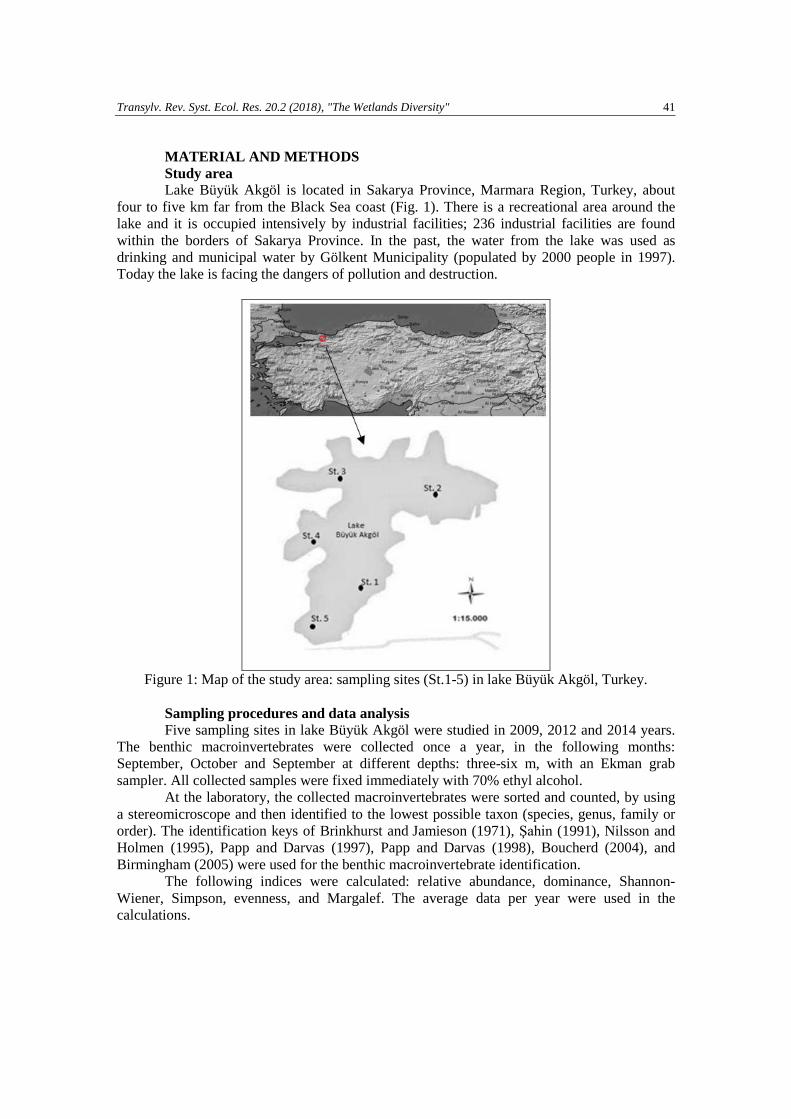
Transylv. Rev. Syst. Ecol. Res. 20.2 (2018), "The Wetlands Diversity" 41
MATERIAL AND METHODS Study area Lake Büyük Akgöl is located in Sakarya Province, Marmara Region, Turkey, about four to five km far from the Black Sea coast (Fig. 1). There is a recreational area around the lake and it is occupied intensively by industrial facilities; 236 industrial facilities are found within the borders of Sakarya Province. In the past, the water from the lake was used as drinking and municipal water by Gölkent Municipality (populated by 2000 people in 1997). Today the lake is facing the dangers of pollution and destruction.
Figure 1: Map of the study area: sampling sites (St.1-5) in lake Büyük Akgöl, Turkey.
Sampling procedures and data analysis Five sampling sites in lake Büyük Akgöl were studied in 2009, 2012 and 2014 years. The benthic macroinvertebrates were collected once a year, in the following months: September, October and September at different depths: three-six m, with an Ekman grab sampler. All collected samples were fixed immediately with 70% ethyl alcohol. At the laboratory, the collected macroinvertebrates were sorted and counted, by using a stereomicroscope and then identified to the lowest possible taxon (species, genus, family or order). The identification keys of Brinkhurst and Jamieson (1971), Şahin (1991), Nilsson and Holmen (1995), Papp and Darvas (1997), Papp and Darvas (1998), Boucherd (2004), and Birmingham (2005) were used for the benthic macroinvertebrate identification. The following indices were calculated: relative abundance, dominance, Shannon-Wiener, Simpson, evenness, and Margalef. The average data per year were used in the calculations.

N. Arslan et al. ‒ Dreissena polymorpha as an invader in Büyük Akgöl Lake (39 ~ 50) 42
RESULTS The benthic macroinvertebrate fauna in lake Büyük Akgöl in the study period was represented by the following taxonomic groups: Gastropoda, Bivalvia, Oligochaeta, Chironomidae, Trichoptera, Ceratopogonidae, Ephemeroptera, Odonata, Chaoboridae, and Hirudinea. The taxa collected at the five sites in 2009, 2012 and 2014, and their relative abundance (in %) are given in table 1. Table 1: Benthic macroinvertebrate taxa in lake Büyük Akgöl, Turkey, and their relative abundance (in %) in 2009, 2012 and 2014.
Main taxonomic
group Taxa 2009 2012 2014
Gastropoda Planorbarius corneus (Linnaeus, 1758)
5.57 1.42 1.42
Lymnea stagnalis (Linnaeus, 1758)
12.80 11.67 12.28
Viviparus viviparus (Linnaeus, 1758)
16.85 16.43 16.73
Theodoxus fluviatilis (Linnaeus, 1758)
5.19 4.09 4.03
Bithynia sp. 1.18 1.18 0.00 Valvata piscinalis
(Müller, 1774) 0.84 0.84 3.20
Borystenia naticina (Menke, 1845)
9.36 4.73 1.22
Gyraulus sp. 0.61 0.63 1.14 Physa acuta
Draparnaud, 1805 0.50 0.32 2.40
Radix labiata (Rossmassler, 1835)
0.61 0.10 0.00
Bivalvia Dreissena polymorpha
(Pallas, 1771) 19.60 32.40 34.80
Bivalvia sp. 7.35 5.80 1.03 Oligochaeta Potamothrix hammoniensis
(Michaelsen, 1901) 8.37 9.17 10.03
Tubifex tubifex (Müller, 1774)
1.16 2.01 1.21
Limnodrillus hoffmeisteri Claparède, 1862
0.25 2.24 1.54
Potamothrix bedoti (Piguet, 1913)
0.49 0.12 1.20
Dero digitata Müller, 1773
0.31 0.31 0.31
Nais communis Piguet, 1906
0.68 0.42 0.31
Ophidonais serpentine Müller, 1773
0.86 1.03 1.03

Transylv. Rev. Syst. Ecol. Res. 20.2 (2018), "The Wetlands Diversity" 43
Table 1 (continued): Benthic macroinvertebrate taxa in lake Büyük Akgöl, Turkey, and their relative abundance (in %) in 2009, 2012 and 2014.
Main taxonomic
group Taxa 2009 2012 2014
Stylaria lacustris (Linnaeus, 1767)
0.01 0.01 0.52
Pristina aeguiseta (Bourne, 1891)
0.05 0.05 0.00
Chironomidae Procladius
(Holotanypus) sp. 1.39 0.63 0.90
Fleuria lacustris Kieffer, 1924
0.22 0.12 0.17
Zalutschia sp. 0.01 0.01 0.09 Einfeldia pagana
(Meigen, 1838) 0.94 0.25 0.93
Parachironomus swammerdami (Kruseman, 1933)
0.80 0.72 0.00
Chironomus plumosus (Linnaeus, 1758)
0.33 0.33 0.52
Chironomus (Camptoch) tentans Fabricious, 1805
1.27 2.03 2.45
Monopsectrocladius sp. 0.16 0.16 0.37 Dicrotendipes nervosus
(Staeger, 1839) 0.84 0.28 0.00
Others Trichoptera 0.50 0.21 0.03 Ceratopogonidae 0.03 0.02 0.01 Ephemeroptera 0.22 0.04 0.03 Odonata 0.02 0.02 0.04 Chaoboridae 0.53 0.20 0.05 Hirudinea 0.12 0.01 0.01 Total 100.00 100.00 100.00
In 2009, a total of 85 individuals, belonging to 36 taxa, were identified. The benthic macroinvertebrate fauna consisted of Gastropoda (53.4%), Bivalvia (26.8%), Oligochaeta (12.6%), Chironomidae (5.9%) and other taxonimic groups, including Trichoptera, Ceratopogonidae, Ephemeroptera, Odonata, Chaoboridae, and Hirudinea (1.04%). The species with the highest relative abundance were as follow: Viviparus viviparus (16.85%) and Lymnea stagnalis (12.8%) from Gastropoda, Dreissena polymorpha (19.6%) from Bivalvia, Potamothrix hammoniensis (8.37%) from Oligochaeta, and Procladius (Holotanypus) sp. (1.39%) and Chironomus (C.) tentans (1.27%) from Chironomidae (Tab. 1).

N. Arslan et al. ‒ Dreissena polymorpha as an invader in Büyük Akgöl Lake (39 ~ 50) 44
In 2012, 90 individuals, belonging to 36 taxa were identified, while in 2014, 92 individuals belonging to 28 taxa, were identified in the samples. The species with the highest relative abundance were the same: V. viviparus (16.43% and 16.93%, respectively), L. stagnalis (11.67% and 12.28%, respectively), D. polymorpha (32.40% and 34.80%, respectively), P. hammoniensis (9.17% and 10.03%, respectively) and C. (Camptoch) tentans (2.03% and 3.01%, respectively) (Tab. 1). The results show that from 2009 to 2012, Bivalvia and Oligochaeta increased (38.2% and 15.3% respectively), whereas the other taxonomic groups, in particular, Gastropoda and Chironomidae (41.4% and 4.5%, respectively) were found to decrease. However, when considering the whole study period (2009-2014), the taxonomic groups of Gastropoda, Oligochaeta and Chironomidae increased, whereas the other taxonomic groups (Trichoptera, Ceratopoganidae, Ephemeroptera, Odonata, Chaoboridae, and Hirudinea) decreased (Fig. 4).
Figure 2: Relative abundance of the main taxonomic groups of benthic macroinvertebrates
in lake Büyük Akgöl in 2009, 2012 and 2014.
The values of diversity indices (dominance, Shannon-Wiener, Simpson, evenness, and Margalef) for the three study years are given in table 2. The results show that the number of the identified taxa and the values of diversity indices from 2009 to 2014 decreased (Tab. 2). Table 2: Values of diversity indices calculated on benthic macroinvertebrates in lake Büyük Akgöl, Turkey, in 2009, 2012 and 2014.
Indices/Years 2009 2012 2014 Taxa 36 36 31 Individuals 85 90 91 Dominance 0.1542 0.2016 0.217 Shannon-Wiener 2.81 2.433 2.350 Simpson 0.8458 0.7984 0.783 Evenness 0.4612 0.3166 0.338 Margalef 7.878 7.778 6.651
Transylv. Rev. Syst. Ecol. Res. 20.2 (2018), "The Wetlands Diversity" 45
DISCUSSION In the current study, the relative abundance of the following taxa increased from 2009 to 2014: Valvata piscinalis, Gyraulus sp., and Physa acuta from Gastropoda, P. hammoniensis, Limnodrillus hoffmeisteri, Potamothrix bedoti, and Stylaria lacustris from Oligochaeta, and Chironomus plumosus and Ch. (C.) tentans from Chironomidae (Tab. 1). In the same period, the relative abundance of D. polymorpha increased twice. Most of these species are poly- and mesosaprobic species, tolerant to organic pollution (Hellawell, 1986). They are very common in the Turkish freshwaters (Yıldırım et al., 2006; Yıldız et al., 2007; Arslan et al., 2010). The genera Potamothrix, Limnodrilus and Stylaria are widely distributed throughout the world (Wetzel et al., 2000). P. hammoniensis, which is a freshwater euryhalin species (Grigelis, 1980), was the most abundant Oligochaeta species in the lake. Many species of the genus Chironomus are known as excellent indicators of organic pollution (Simpson and Bode, 1980), and the high density of Chironomus, shows eutrophic features of the environment (Tate and Heiny, 1995; Botts, 1997). Chironomus (Camptoch) tentans which was most abundant species from Chironomidae in this study is referred as being positive indicator of organic pollution (Arslan et al., 2010). Some certain molluscs’ species are indicators of water quality (Oehlmann and Schulte-Oehlmann, 2002. Freshwater pulmonates have distributed world-wide and broad environmental tolerances (Strong et al., 2008). Griffiths et al. (1993) were reported that when Dreissena population increased, densities of gastropods generally increased. Most abundant species from Gastropoda were Lymnea stagnalis and Viviparus viviparus in studied years. When examined according to the increasing rate of Gastropoda species dominancy, Valvata piscinalis and Physa acuta were increased almost three times more (from 0.84% to 3.20% and from 0.50% to 2.40%, respectively) whereas Borystenia naticina was decreased. According to results of our present study, in 2009, Valvata piscinalis and Physa acuta were of 0.008% and 0.005% of total zoobenthic community, respectively. In six years, these dominancy ratios were increased to 0.032% and 0.024%, respectively. Although these two species populations have increased, this increase is still not a very high ration ratio in general zoobenthic fauna. Variation in population density of three gastropod species (Lymnea stagnalis, Viviparus viviparous and Borystenia naticina) can also be due to a negative change in water quality. However, since some water quality parameters couldn’t have been measured in the present study, it is difficult to conclude that the population change of gastropoda species is due to water quality change and/or Dreissena population pressure. Zebra mussels provide habitats altering the surface of substrate and providing spatial refuge and food for other benthic invertebrates. Besides providing shell-generated habitat to benthic macroinvertebrates, particulate organic matters produced by Dreissena are used by other macroinvertebrates as food and also increase their community (Karatayev et al., 2002; 2005). In the results of present study, density of some Chironomidae and Oligochaeta species were increased almost three times more. In the current study, dominancy of Chironomidae and Oligochaeta consisting of 0.12% and 0.059% of whole zoobenthic community in 2009, respectively was observed. In 2014, these dominancy values were changed to 0.16% and 0.054%. Wolnomiejski (1970) was studied with effect of Dreissena to benthic macroinvertebrate community reported that zebra mussels are used as substrate or shelter by many benthic taxa (including the isopod, larval chironomids and the leech). We agree with authors of previous studies.
N. Arslan et al. ‒ Dreissena polymorpha as an invader in Büyük Akgöl Lake (39 ~ 50) 46
Community of benthic macroinvertebrates in the littoral areas of lakes and rivers increase (often doubling) by dreissenid colonization. Furthermore, zebra mussels have negative effect on particular taxonomic and functional groups (like densities of native bivalves) (Ward and Ricciardi, 2007). In the present study, when dominancy of D. polymorpha increased, other Bivalvia species with unidentified level of species were decreased almost six times. Stewart et al. (1998) were reported that causing changes in biomass and densities of macroinvertebrate taxa by Dreissena altered macroinvertebrate community composition lead to changes in the relative abundance of other macroinvertebrates. Dominancy of chironomid Dicrotendipes decreased in the presence of Dreissena. Results of their study were showed that Dreissena had adverse effects on Dicrotendipes. As seen in table 1, Dicrotendipes nervosus and Parachironomus swammerdami from Chironomidae were detected in 2009, their population density decreased in 2012 and finally in 2014 these species were not found in the lake; however, total dominancy of Chironomidae were increased. Zebra mussel biodeposition was assumed responsible for increased abundances of deposit feeding chironomids and oligochaetes in European lakes (Lyakhnovich et al., 1982; Smit et al., 1993). Griffiths (1993) suspected that population increases in Potamothrix moldaviensis and Spirosperma ferox in lake Saint Clair were resulted from deposition of feces and pseudofeces by Dreissena. Griffiths believed that increased densities of submerged vascular plants and benthic algae following colonization of lake Saint Clair by Dreissena contributed to the observed increase in macroinvertebrate populations. In our study, dominancy of Oligochaeta was increased from 12.6% to 16.15% (between the years 2009-2014) while dominancy of Dreissena was almost doubling. These results also showed that Dreissenia polymorpha had a positive effect on zoobenthic community structure at least in mesosaprob and oligosabrob taxa such as Oligochaeta and Chironomidae, as reported in previous studies (Wolnomiejski, 1970; Griffth, 1993). Consequently, macroinvertebrate fauna of lake Büyük Akgöl is not diverse, but 30 species (10 species from Gastropoda, two species from Bivalvia, nine species from Oligochaeta and nine species from Chironomidae) were identified in the lake. Identified species (especially Potamothrix hammoniensis, Limnodrilus hoffmeisteri and Tubifex tubifex from Oligochaeta and Chironomus plumosus and Chironomus (Camptoch) tentans from Chironomidae) have especially broad ecological valence. Within six years, while dominancy of D. polymorpha was increased, the benthic macroinvertebrate community structure changed in terms of taxonomical composition and relative abundance of functional groups. Population density of some species which are Valvata piscinalis and Physa acuta from Gastropoda, Potamothrix hammoniensis, Limnodrillus hoffmeisteri, Potamothrix bedoti, Ophidonais serpentina and Stylaria lacustris from Oligochaeta, Zalutschia sp., C. plumosus, C. (Camptoch) tentans and Monopsectrocladius sp. from Chironomidae were increased. On the other side, some species which are Bithynia sp. and Radix labiata from Gastropoda, Pristina aeguiseta from Oligochaeta, Parachironomus swammerdami and Dicrotendipes nervosus from Chironomidae were not found in the lake. As can be caused this situation changes in environmental conditions, may be negative population effect of D. polymorpha on sensitive species. It is clear that D. polymorpha has been dispersing different benthic habitat of lake Büyük Akgöl at least since the beginning of the study and is still invading. Present study results showed that when population density of D. polymorpha increases, benthic invertebrate communities change in terms of taxonomical composition and relative abundance of functional groups.

Transylv. Rev. Syst. Ecol. Res. 20.2 (2018), "The Wetlands Diversity" 47
ACKNOWLEDGEMENTS The study was carried out under the project no. 109T076 by TUBITAK (The Scientific and Technological Research Council of Turkey) and partly under Project no. 201319A106, by Eskisehir Osmangazi University-BAP for determining zoobenthic fauna of lake Büyük Akgöl. In addition, authors thanks to Teodora Trichkova, Bulgarian Academy of Sciences, Institute of Zoology, for consultation.
N. Arslan et al. ‒ Dreissena polymorpha as an invader in Büyük Akgöl Lake (39 ~ 50) 48
REFERENCES 1. Ackerman J. D., Loewen M. R. and Hamblin P. F., 2001 ‒ Benthic-pelagic coupling over a
Zebra Mussel reef in western lake Erie, Limnology and Oceanography, 46, 892-904. 2. Afanasiev S. A., 1987 ‒ The differences in oligochaeta distribution in periphyton on substrate
with different structure, 38-41, in Kachalova O. L. and Parele E. A. (eds), Water Oligochaeta, Transactions of the Six All-Union Symposium, Biological Institute of the Academy of Science Latvian SSR Press, Riga. (in Russian)
3. Aksu S., Yıldız D. and Güngör A. P., 2017 ‒ How Zebra mussels threaten to water supply security and effects of preventive measures in Turkey, World Scientific News, 64, 99-126.
4. Anastasiu P., Preda C., Bănăduc D., and Cogălniceanu D., 2017 ‒ Alien species of European Union concern in Romania, Transylvanian Review of Systematical and Ecological Research, volume 19.3, The Wetlands Diversity, 93-106, ISSN-L 1841 – 7051, ISSN 2344-3219.
5. Arslan N., Ayık Ö. and Şahin Y., 2010 ‒ Diversity and structure of Chironomidae (Diptera) limnofauna of lake Uluabat, a Ramsar site of Turkey, and their relation to environmental variables, Turkish Journal of Fisheries and Aquatic Sciences, 10, 315-322.
6. Birmingham M., Heimdal D., Todd H., Ken K., Richard L., Jim W., Jacklyn N., Brian S. and Tom W., 2005 ‒ Benthic macroinvertebrate key, Iowater volunteer water quality monitoring, http://www.iowater.net/
7. Botts P. S., 1997 ‒ Spatial pattern, patch dynamics and successional change: chironomid assemblages in a lake Erie coastal wetland, Freshwater Biology, 37, 277-286.
8. Botts P. S., Patterson B. A. and Schloesser D. W., 1996 ‒ Zebra mussel effects on benthic invertebrates: physical or biotic? Journal of North American Benthological Society, 15, 179-184.
9. Boucherd R. W. Jr., 2004 ‒ Guide to aquatic invertebrates of the upper Midwest, Universtiy of Minnesota, ISBN-00511309763.
10. Brinkhurst R. O. and Jamieson B. G. M., 1971 ‒ Aquatic Oligochaeta of the world, University of Toronto, 860.
11. Daniszewski P., 2015 ‒ Total alkaline phosphatase activity (ALP-EC 3.1.3.1) of water in the river Odra estuary (North-West Poland), World News of Natural Sciences, 1, 1-10.
12. Daunys D., Zemlys P., Olenin S., Zaiko A. and Ferrarin C., 2006 ‒ Impact of the Zebra mussel Dreissena polymorpha invasion on the budget of suspended material in a shallow lagoon ecosystem, Helgoland Marine Research, 60, 113-120.
13. Dermott R. and Munawar M., 1993 ‒ Invasion of lake Erie offshore sediments by Dreissena, and its ecological implications, Canadian Journal of Fisheries and Aquatic Sciences, 50, 2298-2304.
14. Draszawka-Bołzan B. and Cyraniak E., 2015 ‒ Quality monitoring of marine coastal waters in Poland, World News of Natural Sciences, 1, 11-18.
15. DSİ, 2005 ‒ Hidroelektrik santrallarda sorun zaratan Zebra midye araştırmaları raporu, DSİ Genel Müdürlüğü İşletme ve Bakım Dairesi Başkanlığı, Ankara, Türkiye. (in Turkish)
16. Dusoge K., 1966 ‒ Composition and interrelations between macrofauna living on stones in the littoral of Mikolajskie Lake, Ekologia Polska Seria A, 14, 755-762.
17. Geldiay R. and Bilgin F. H., 1973 ‒ Batı anadolu’nun bazı tatlı sularında yaşayan bir bivalv türü “Dreissena polymorpha” (Pallas) Hakkında, Ege Üniversitesi İlmi Raporlar Serisi, 158, 1973, Ege Üniversitesi Matbaası, Bornova. (in Turkish)
18. Griffiths C. L., Hockey P. A. R., van Erkom Schurink C. and Le Roux P. J., 1992 ‒ Marine invasive aliens on South African shores: implications for community structure and trophic functioning, South African, Journal of Marine Science, 12, 713-722.
19. Griffiths R. W., 1993 ‒ Effects of Zebra mussels (D. polymorpha) on the benthic fauna of lake St. Clair, in Zebra mussels: biology, impacts, and control, Lewis Publishers, Boca Raton, FL, 415-437.
20. Grigelis A., 1980 ‒ Ecological studies of aquatic Oligochaetes in the USSR, in Brinkhurst R. O. and Cook D. G. (eds), Aquatic Oligochaeta Biology, Plenum Press, New York, 225-240.
21. Hellawell J. M., 1986 ‒ Biological indicators of freshwater pollution and environmental management, Elsevier, London, 452-508.

Transylv. Rev. Syst. Ecol. Res. 20.2 (2018), "The Wetlands Diversity" 49
22. Hulme P. E., 2009 ‒ Delivering alien invasive species inventories for Europe (DAISE) Handbook of alien species in Europe, Springer, New York.
23. Karatayev A. Y., Burlakova L. E. and Padilla D. K., 2005 ‒ Contrasting distribution and impacts of two freshwater exotic suspension feeders, Dreissena polymorpha and Corbicula fluminea, in Dame R. and Olenin S. (eds), The comparative roles of suspension feeders in ecosystems, NATO Science Series IV: earth and environmental sciences, 47, Netherlands, Springer, 239-262.
24. Karayayev A., Burlakova L. E. and Padilla D. K., 2002 ‒ Impacts of Zebra mussels on aquatic communities and their role as ecosystem engineers, 433-446, in Leppakoski E., Gollasch S. and Olenin S. (eds), Invasive Aquatic Species of Europe: Distribution, Impacts and Management, Springer, Dordrecht, Netherlands.
25. Kharchenko T. G. and Protasov A. A., 1981 ‒ On consortia in water ecosystems, Gidrobiol, 17, 15-20. (in Russian)
26. Luque G. M., Bellard C., Bertelsmeier C., Bonnaud E., Genovesi P., Simberloff D. and Courchamp F., 2013 ‒ The 100th of the world’ worst invasive alien species, Biological invasions, DOI: 10.1007/s10530-013-0561-5.
27. Lyakhnovich U. P., Gavrilov S. I., Karataev A. Y., Karataeva I. V. and Myakhaeva T. I., 1982 ‒ Long-term changes in the macrobenthos of the Lukoml’skoe Lake, Vyestsi Akad, Navuk, BSSR Syer Biyal, Navak, 1982, 91-93, (Translated from Russian by New York Sea Grant Extension, Brockport, NY).
28. Minchin D. and Zaiko A., 2013 ‒ Variability of the Zebra mussel (Dreissena polymorpha) impacts in the Shannon River system, in Quagga and Zebra Mussels: Biology, Impacts and Control, Nalepa T. F. and Schlosser D. W. (eds), CRC Press, Taylor and Francis Group: Boca Raton, FL, 587-597.
29. Nilsson A. N. and Holmen M., 1995 ‒ The Aquatic Adephaga (Coleoptera) of Fennoscandia and Denmark, II, Dytiscidae, Fauna Entomologica Scandinavica, 32, Brill E. J., Leiden, 192 s.
30. Oehlman J. and Schulte-Oehlman U., 2002 ‒ Molluscs as bioindicator, chapter 17, (eds) Markert B. A., Breure A. M. and Zechmeister H. G., Bioindicators and Biomonitors, 577-635.
31. Papp L. and Darvas B., 1997 (eds) ‒ Contributions to a manual of Palaearctic Diptera, 2, Nematocera and lower Brachycera, Science Herald, Place, 592.
32. Papp L. and Darvas B., 1998 ‒ Contributions to a manual of Palearctic Diptera, 3, higher Brachycera, Science herald, Budapest, ISBN 963 04 8838 8, 880s.
33. Pimentel D., Lach L., Zuniga R. and Morrison D., 2000 ‒ Environmental and economic costs associated with non-indigenous species in the United States, BioScience, 50, 1, 53-65.
34. Pollux B. J. A., Minchin D., Van der Velde G., Van Alen T., Moon-Van der Staay S. and Hackstein J. H. P., 2003 ‒ Zebra mussels (Dreissena polymorpha) in Ireland, AFLP fingerprinting and boat traffic both indicate an origin from Britain, Freshwater Biology, 48, 1127-1139.
35. Quinn A., Gallardo B. and Aldridge C. D., 2013 ‒ Quantifying the ecological niche overlap between two interacting invasive species: the Zebra mussel (Dreissena polymorpha) and the Quagga mussel (Dreissena rostriformis bugensis), Aquatic Conservation: Marıne And Freshwater Ecosystems (2013) Published online in Wiley Online Library (wileyonlinelibrary.com), DOI: 10.1002/aqc.2414.
36. Ricciardi A. and Rasmussen J. B., 1999 ‒ Extinction Rates of North American Freshwater Fauna, Conservation Biology, 13, 1220-1222.
37. Simpson K. W. and Bode R. W., 1980 ‒ Common larvae of Chironomidae (Diptera) from New York State streams and rivers with particular reference to the fauna of artificial substrates, Bulletin 439 of the New York State Museum, Albany, 105.
38. Smit H., Bij de Vaate A., Reeders H. H., van Nes E. H. and Noordhuis R., 1993 ‒ Colonization, ecology, and positive aspects of Zebra mussels (Dreissena polymorpha) in the Netherlands, in Zebra mussels: biology, impacts, and control, Nalepa T. F. and Schloesser D. W. (eds), Lewis Publishers, Boca Raton, Fla., 55-77.

N. Arslan et al. ‒ Dreissena polymorpha as an invader in Büyük Akgöl Lake (39 ~ 50) 50
39. Stewart T. W. and Haynes J. M., 1994 ‒ Benthic macroinvertebrate communities of southwestern lake Ontario following invasion of Dreissena, Jurnal of Great Lakes Research, 20, 479-493.
40. Stewart T. W., Miner J. G. and Lowe R. L., 1998 ̶Quantifying mechanisms for Zebra mussel effects on benthic macroinvertebrates: organic matter production and shellgenerated habitat, Journal of North American Benthological Society, 17, 81-94.
41. Strong E. E., Gargominy O., Winston F. P. and Bouchet P., 2008 ‒ Global diversity of gastropods (Gastropoda; Mollusca), in freshwater, Hydrobiologia, 595, 149-166.
42. Stuckey R. L. and Moore D. L., 1995 ‒ Return and increase in abundance of aquatic flowering plants in Put-in-Bay Harbor, Lake Erie, Ohio, Ohio Journal of Science, 95, 261-266.
43. Şahin Y., 1991 ‒ Türkiye chironomidae potamofaunası (Chironomidae Potamofauna of Turkey), Tubitak, project no. TBAG-869, VHAG-347, TBAG-669, TBAG-79, 88 s. (in Turkish)
44. Tate C. M. and Heiny S. J., 1995 ‒ The ordination of benthic invertebrate communities in the South Platte Basin in relation to environmental factors, Freshwater Biology, 33, 439-454.
45. Yıldırım M. Z., Gümüş B. A., Kebapçı Ü. and Bahadır-Koca S., 2006 ‒ The Basommatophoran pulmonate species (Mollusca: Gastropoda) of Turkey, Turkish Journal of Zoology, 30, 445-458.
46. Yıldız S., Ustaoğlu M. R. and Balık S., 2007 ‒ The Oligochaeta (Annelida) fauna of Yuvarlak Stream (Köyceğiz-Turkey), Turkish Journal of Fisheries and Aquatic Sciences, 7, 01-06.
47. Ward J. M. and Ricciardi A., 2007 ‒ Impacts of Dreissena invasions on benthic macroinvertebrate communities: A meta-analysis, Diversity Distribution, 13, 155-165.
48. Wetzel M. J., Kathman R. D., Fend S. and Coates K. A., 2000 ‒ Taxonomy, systematic and ecology of freshwater Oligochaeta, Workbook prepared for North American Benthological Society technical information Workshop, 48th Annual Meeting, Keystone Resort, CO., 120.
49. Wilas J., Draszawka-Bołzan B. and Cyraniak E., 2016 ‒ Wastewater reuse, World News of Natural Sciences, 5, 33-43.
50. Wolnomiejski N., 1970 ‒ The Effects of Dreissena polymorpha Pall., Aggregation on the differentiation of the benthonic macrofauna, Zecz nauk UMK, 25, 31-39.

Transylv. Rev. Syst. Ecol. Res. 20.2 (2018), "The Wetlands Diversity" 51
AQUATIC AND SEMIAQUATIC HETEROPTERA (NEPOMORPHA) FROM THE STREI RIVER BASIN
Daniela ILIE * and Horea OLOSUTEAN **
* “Lucian Blaga” University of Sibiu, Faculty of Sciences, Department of Environmental Sciences and Physics, Dr. Ion Rațiu Street 5-7, RO-550012, Sibiu, Romania, [email protected] ** “Lucian Blaga” University of Sibiu, Faculty of Sciences, Applied Ecology Research Center, Dr. Ion Rațiu Street 5-7, RO-550012, Sibiu, Romania, [email protected]
DOI: 10.2478/trser-2018-0012 KEYWORDS: aquatic true bugs, semiaquatic true bugs, habitats, Romania.
ABSTRACT During a field campaign in the Strei River basin in August 2014, seven suitable habitats for aquatic and semi-aquatic true bugs were identified from the confluence of the Strei River with the Bărbat River down to the confluence with the Mureș River. Forty-eight individuals belonging to 15 species and nine families of aquatic and semi-aquatic true bugs were sampled. We mention two species considered rare in Romanian fauna: Hebrus montanus and Microvelia pygmaea. The statistic-mathematical analysis showed the similarity of the true bugs’ communities from habitats with similar conditions, as well as the relation of each species with particular habitat conditions, emphasizing the fact that Gerris lacustris is present in the majority of the investigated habitats, while the rest of the species are conditioned mostly by the ratio between the areas with open water and those covered by aquatic vegetation.
RESUMÉ: Les hétéroptères aquatiques et semi-aquatiques du bassin de la rivière Strei. On cadre d’une campagne de terrain effectuée dans le bassin de la rivière Strei en août 2014, ont été identifiés sept habitats favorables aux hétéroptères aquatiques et semi-aquatiques dans la zone de confluence des rivières Strei et Bărbat, jusqu’à le jet de la dernière dans la rivière Mureş. On a collecté 48 exemplaires appartenant à 15 espèces d’hétéroptères aquatiques et semi-aquatiques, encadrées en neuf familles. Il faut mentionner l’existence de deux espèces, considérées rares, sur le territoire du pays: Hebrus montanus et Microvelia pygmaea. L’analyse statistique ‒ mathématique effectuée, a mis en évidence la similitude des communautés d’hétéroptères dans des stations qui disposent des conditions similaires de vivre, aussi que la relation de chaque espèce avec les variables de biotope, en mettant en évidence le fait que Gerris lacustris occupe la majorité d’habitats de la zone, et les autres espèces sont conditionnées en principal de relation entre les zones qui disposent de végétation aquatique et les zones avec de l’eau libre.
REZUMAT: Heteropterele acvatice și semiacvatice din bazinul râului Strei. În cadrul unei campanii de teren efectuată în bazinul râului Strei, în august 2014 au fost identificate un număr de şapte habitate favorabile heteropterelor acvatice şi semiacvatice, în sectorul de la confluenţa Streiului cu râul Bărbat şi până la vărsarea acestuia în Mureş. Au fost colectate 48 exemplare aparţinând la 15 specii de heteroptere acvatice și semiacvatice, încadrate în nouă familii. Menţionăm semnalarea a două specii considerate rare pe teritoriul ţării: Hebrus montanus şi Microvelia pygmaea. Analiza statistico-matematică efectuată a relevat similitudinea comunităților de heteroptere din stații cu condiții similare de habitat, precum și relația fiecărei specii cu variabilele de biotop, reliefându-se faptul că Gerris lacustris ocupă majoritatea habitatelor din areal, iar restul speciilor sunt condiționate în principal de raportul dintre zonele cu vegetația acvatică și cele cu apă liberă.

D. Ilie and H. Olosutean – Heteroptera from the Strei River basin (51 ~ 62) 52
INTRODUCTION Aquatic and semiaquatic bugs, reunited at present day as Infraorder Nepomorpha (Aukema, 2013), are a relatively small, polyphyletic group, with species usually considered as having wide ecological tolerances (Andersen, 1982; Jansson, 1986; Olusutean et al., 2009; Olosutean and Ilie, 2010a). Aquatic and semiaquatic bugs were sampled in all types of water bodies, but seem to prefer stagnant or slow flowing waters, with a relatively constant presence of aquatic and semi-aquatic vegetation (Karaouazas and Gritzalis, 2006; Nosek et al., 2007; Ilie and Olosutean, 2012). Studies made in the mountainous regions of Romania show that high velocity of the water flow is a restrictive factor for the group (Olosutean and Ilie, 2010a; Ilie and Olosutean, 2012). The Strei River is one of the main tributaries of the Mureş River (the longest river in Romania, except the Danube), with a length of 92 km and an basin surface of 1,926 km2, mostly in mountainous areas; the Strei River flows into the Mureş River in the sector called the Lower Mureş Couloir, between Alba Iulia and Lipova (Ujvari, 1972). The study aims to provide insight about the aquatic and semiaquatic Heteroptera fauna from the Strei River valley, where no previous mentions of the group’s members were made, as well as to analyse the relations between species and habitat characteristics.
MATERIAL AND METHODS Sampling design A single field campaign was conducted for sampling in August 2014, samples being collected with a 1,000 cm2 entomological net with two mm meshes. Forty-five minutes similar sampling session were taken for all samples, in order to provide quantitative data, all aspects of the habitats being covered (open water, shores with and without vegetation, submerged and floating vegetation areas, etc.). The samples were preserved in 70% ethylic alcohol. They were identified based on the works of Poisson (1957) and Jansson (1986). The taxonomy is presented according to Aukema (2013). Sampling area Upstream of the small village of Baru, the Strei River has a typical mountainous course, with narrow widths of the riverbed, high velocities of the water flow and with undeveloped vegetation on the banks; no suitable habitats for aquatic and semi-aquatic Heteroptera were found. Downstream of the confluence with the Bărbat River and up to the confluence with the Mureş River, seven suitable habitats were identified (encoded S1 to S7; Fig. 1), from which the processed biological material was sampled.

Transylv. Rev. Syst. Ecol. Res. 20.2 (2018), "The Wetlands Diversity" 53
Figure 1: Sampling stations S1-S7.

D. Ilie and H. Olosutean – Heteroptera from the Strei River basin (51 ~ 62) 54
S1 (45º31.945’ N, 23º01.983’ E, 357 m a.s.l.) (Fig. 2) Sampling was performed in the Strei River, in an enlarged sector of the riverbed with relatively low water flow velocity and sandy substratum. The vegetation on the banks consisted of Agrostis stolonifera, Phragmites australis, Salix sp.; aquatic vegetation was absent.
Figure 2: Sampling station S1.
S2 (45º35.619’ N, 22º58.102’ E, 315 m a.s.l.) (Fig. 3) Sampling was performed in the Strei River, in an enlarged sector of the riverbed with relatively low water flow velocity and sandy substratum. The vegetation on the banks consisted of Agrostis stolonifera, Phragmites australis, Salix sp., and aquatic vegetation was absent.
Figure 3: Sampling station S2.

Transylv. Rev. Syst. Ecol. Res. 20.2 (2018), "The Wetlands Diversity" 55
S3 (45º49.745’ N, 23º02.129’ E, 201 m a.s.l.) (Fig. 4) The station consisted of a chain of small stony bottom lakes resulted from the excavations for gravel material (used for the construction of the highway), near the village of Băcia. The shores were covered by Typha latifolia, Phragmites australis, Mentha aquatica and the invasive Conyza canadensis. The floating Polygonum amphibium covered an important part of the station, as well as the vegetal association Ceratophyletum.
Figure 4: Sampling station S3.
S4 (45º43.998’ N, 23º00.843’ E, altitude 243 m) (Fig. 5) The sampling station is located on the Strei River, upstream a dam built during the communist period to provide water to industrial activities. Currently, the water flows uninterrupted, but the riverbed is widened, deep and strongly embanked. The sampled area was covered with Potamogeton crispus.
Figure 4: Sampling station S5.

D. Ilie and H. Olosutean – Heteroptera from the Strei River basin (51 ~ 62) 56
S5 (45º35.639’ N, 22º9.589’ E, 303 m a.s.l.) (Fig. 6) The station is located in the upstream side of lake Covragiu, with deep waters and no aquatic vegetation. A belt of reed and bulrush covers the lake shores and a large quantity of plastic bottles floats in the area.
Figure 6: Sampling station S5.
S6 (45º41.607’ N, 22º59.942’ E, 259 m a.s.l.) (Fig. 7) The sampling station was located in a river meander, near the Ruși Village, with stony substrate covered by a muddy residue and a Salicetum with bulrush and Calamagrosits association on the shores. The sector is presenting very high amplitudes of the water flow caused by the microhydro plant built upstream and is affected by working made for straightening the Strei River near Ruşi Village.
Figure 6: Sampling station S7.
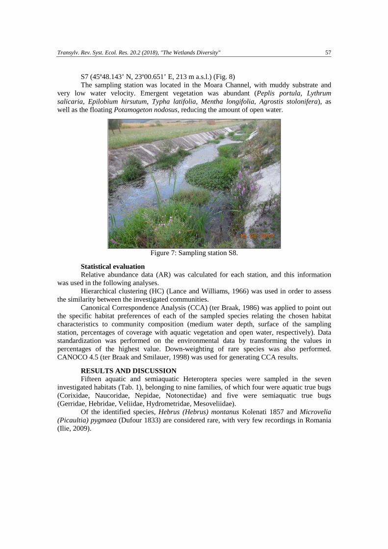
Transylv. Rev. Syst. Ecol. Res. 20.2 (2018), "The Wetlands Diversity" 57
S7 (45º48.143’ N, 23º00.651’ E, 213 m a.s.l.) (Fig. 8) The sampling station was located in the Moara Channel, with muddy substrate and very low water velocity. Emergent vegetation was abundant (Peplis portula, Lythrum salicaria, Epilobium hirsutum, Typha latifolia, Mentha longifolia, Agrostis stolonifera), as well as the floating Potamogeton nodosus, reducing the amount of open water.
Figure 7: Sampling station S8.
Statistical evaluation Relative abundance data (AR) was calculated for each station, and this information was used in the following analyses. Hierarchical clustering (HC) (Lance and Williams, 1966) was used in order to assess the similarity between the investigated communities. Canonical Correspondence Analysis (CCA) (ter Braak, 1986) was applied to point out the specific habitat preferences of each of the sampled species relating the chosen habitat characteristics to community composition (medium water depth, surface of the sampling station, percentages of coverage with aquatic vegetation and open water, respectively). Data standardization was performed on the environmental data by transforming the values in percentages of the highest value. Down-weighting of rare species was also performed. CANOCO 4.5 (ter Braak and Smilauer, 1998) was used for generating CCA results.
RESULTS AND DISCUSSION Fifteen aquatic and semiaquatic Heteroptera species were sampled in the seven investigated habitats (Tab. 1), belonging to nine families, of which four were aquatic true bugs (Corixidae, Naucoridae, Nepidae, Notonectidae) and five were semiaquatic true bugs (Gerridae, Hebridae, Veliidae, Hydrometridae, Mesoveliidae). Of the identified species, Hebrus (Hebrus) montanus Kolenati 1857 and Microvelia (Picaultia) pygmaea (Dufour 1833) are considered rare, with very few recordings in Romania (Ilie, 2009).

D. Ilie and H. Olosutean – Heteroptera from the Strei River basin (51 ~ 62) 58
Table 1: List and number of individuals of the species from the investigated habitats. No. Taxa S1 S2 S3 S4 S5 S6 S7 Total Infraorder Nepomorpha Popov, 1968 Family Corixidae Leach, 1815 1. Sigara (Pseudovermicorixa) nigrolineata
nigrolineata (Fieber, 1848) 1 2 3
2. Sigara (Sigara) striata (Linnaeus, 1758) 1 1
Family Naucoridae Leach, 1815 3. Ilyocoris cimicoides cimicoides
(Linnaeus, 1758) 2 2
Family Nepidae Latreille, 1802 4. Nepa cinerea Linnaeus, 1758 1 2 3 5. Ranatra (Ranatra) linearis
(Linnaeus, 1758) 1 1
Family Notonectidae Latreille, 1802 6. Notonecta (Notonecta) glauca glauca
Linnaeus, 1758 1 1 2
Infraorder Gerromopha Popov, 1971 Family Gerridae Leach, 1815
7. Aquarius (Aquarius) paludum (Fabricius, 1794) 1 1 2 4
8. Gerris (Gerris) argentatus Schummel, 1832 1 2 3
9. Gerris (Gerris) lacustris (Linnaeus, 1758) 3 6 1 2 1 13
Family Hebridae Amyot and Serville, 1843 10. Hebrus (Hebrus) montanus
Kolenati, 1857 1 1
Family Veliidae Brullé, 1836 11. Microvelia (Microvelia) reticulata
(Burmeister, 1835) 4 4
12. Microvelia pygmaea (Dufour, 1833) 4 4
Family Hydrometridae Billberg, 1820 13. Hydrometra stagnorum
(Linnaeus, 1758) 1 1 1 3
Family Mesoveliidae Douglas and Scott, 1867 14. Mesovelia furcata
Mulsant and Rey, 1852 3 3
15. Mesovelia vittigera Horváth, 1895 1 1
Number of species 4 3 7 3 1 3 6 ‒ Number of individuals 6 11 13 3 2 4 9 48

Transylv. Rev. Syst. Ecol. Res. 20.2 (2018), "The Wetlands Diversity" 59
Hierarchical clustering (Fig. 9) identified closer relations between the following groups of stations: S1 and S4, both slow flowing areas of Strei River, with a small number of species each represented by one individual; S6 and S2, both located downstream from microhydro plants, with a larger number of species than the previous group, but with a much homogeneous community composition, with Gerris lacustris as the dominant species; S3 and S7, located in areas with almost stagnant water, with well-developed vegetation, where the highest biodiversity was recorded; and S5, a habitat with intense anthropic impact, where only one species was sampled. The CCA ordination (Fig. 10) showed that all the environmental variables are strongly correlated with the first axis, with depth, station area and open water opposed to the percentage of aquatic vegetation (depth: r = ‒0.802; area: r = ‒0.800; open water: r = ‒0.781; aquatic vegetation: r = 0.796). However, they are presenting a consistent correlation with the second axis, with depth and open water opposed to station area and to the percentage of aquatic vegetation (depth: r = ‒0.460; open water: r = ‒0.524; area: r = ‒0.453; aquatic vegetation: r = 0.497). The first two axes of the CCA (eigenvalues λ1 = 0.721, λ2 = 0.431) are explaining 78% of the total variation.
0 10 20 30Distances
S1
S2
S3
S4
S5
S6
S7
Figure 9: Similarity of the investigated communities (AR% data, Euclidean distances, average linkage).

D. Ilie and H. Olosutean – Heteroptera from the Strei River basin (51 ~ 62) 60
The particular preferences of the species sampled, G. lacustris, highly eurivalent species for the Romanian fauna (Olosutean and Ilie, 2010a, b; Ilie and Olosutean, 2012), appears to have no apparent relation to the selected habitat variables, being found in almost all the studied habitats; N. glauca and A. paludum prefers large surfaces of open water and higher water depths; N. cinerea, G. argentatus, S. nigrolineata and H. stagnorum prefer larger habitats with well-developed aquatic vegetation; while a larger group, consisting of H. montanus, the two Microvelia species, R. linearis and I. cimicoides prefer smaller stations with shallow waters and well-developed vegetation, mostly in accordance with the known habitat preferences of the species in Romania (Olosutean and Ilie, 2010a, b, 2013; Ilie and Olosutean, 2012).
Figure 10: CCA biplot for species-habitat relations.

Transylv. Rev. Syst. Ecol. Res. 20.2 (2018), "The Wetlands Diversity" 61
CONCLUSIONS The investigated area presents very few suitable habitats for aquatic and semi-aquatic true bugs. Although we were able to sample a relatively large number of species, the number of individuals present was extremely low, confirming the above conclusion. As known for small, anthropic affected habitats, G. lacustris is the dominant species, while the other species are mainly influenced by the ratio between the areas with open water and those covered by aquatic vegetation, in consistence with our previous studies and with the existing information from the scientific literature.
ACKNOWLEDGEMENTS We would like to thank Mr. Drăgulescu for the identification of plant species.

D. Ilie and H. Olosutean – Heteroptera from the Strei River basin (51 ~ 62) 62
REFERENCES 1. Andersen N. M., 1982 – The Semiaquatic bugs (Gerromorpha) phylogeny, adaptations,
biogeography and classification, Scandinavian Science Press Ltd., Copenhagen, 455. 2. Aukema B., 2013 – Fauna Europaea: Heteroptera, Nepomorpha, The Society for the
Management of Electronic Biodiversity Data, www.faunaeur.org. 3. Ilie D. M., 2009 – Heteropterele acvatice şi semiacvatice (Heteroptera, Nepomorpha,
Gerromorpha) din bazinul mijlociu al Oltului, Edit. Altip, Alba Iulia, 279. (in Romanian) 4. Ilie D. M. and Olosutean H., 2012 – Aquatic and semiaquatic Heteroptera communities from
South-East Transylvanian small rivers, Travaux du Museum National d’Histoire Naturelle “Grigore Antipa”, 55, 2, 207-216.
5. Jansson A., 1986 – The Corixidae (Heteroptera) of Europe and some adjacent regions, Acta Entomologica Fennica, 47, 94.
6. Karaouazas I. and Gritzalis K. C., 2006 – Local and regional factors determining aquatic and semi-aquatic bug (Heteroptera) assemblages in rivers and streams of Greece, Hydrobiologia, 573, 199-212.
7. Lance G. N. and Williams W. T., 1966 – A general theory of classificatory sorting strategies, I, Hierarchical systems, Computer Journal, 9, 373-380.
8. Nosek J. N., Vásárheli T., Bakonyi T. and Oertel N., 2007 – Spatial pattern of waterbugs (Nepomorpha) at different scales in the Szigetköz (Hungary), Biologia, 62, 3, 345-350.
9. Olosutean H. and Ilie D. M., 2010a – Relationships between habitat characteristics and aquatic and semi aquatic Heteroptera community structure in Romanian mountainous regions: a preliminary report, Romanian Journal of Biology – Zoology, 55, 2, 139-148.
10. Olosutean H. and Ilie D. M., 2010b – Aquatic and semiaquatic Heteroptera (Nepomorpha) from the Sulina ‒ Sfântu Gheorghe Canal (Danube Delta, Romania), Transylvanian Review of Systematical and Ecological Research, 10, 55-76.
11. Olosutean H., Ilie D. M., Axinte S. and Drăgoiu A., 2009 – Biodiversity analysis on aquatic and semiaquatic Heteroptera (Heteroptera, Nepomorpha, Gerromorpha) from two Transylvanian (Romania) lake complexes, Acta Oecologica Carpatica, II, 141-149.
12. Olosutean H., Olosutean C. and Ilie D. M., 2013 – High morphological variability of Gerris argentatus (Heteroptera, Gerridae) in the Danube Delta and probably europe’s smallest gerrids’, Transylvanian Review of Systematical and Ecological Research, 15, 2, 111-116.
13. Poisson R, 1957 – Hétéroptères aquatiques, Fédération Française des Sociétés de Sciences Naturelles, Paris, 263. (in French)
14. ter Braak C. J. E., 1986 – Canonical Correspondence Analysis: a new eigenvector technique for multivariate direct gradient analysis, Ecology, 67, 1167-1179.
15. ter Braak C. J. F. and Smilauer P., 1998 – CANOCO Reference Manual and User’s Guide to CANOCO for Windows: Software for Canonical Community Ordination (Version 4), Microcomputer Power, Ithaca, 351.
16. Ujvari I, 1972 – Geografia apelor României, Edit. Ştiinţifică, Bucureşti, 592. (in Romanian)

Transylv. Rev. Syst. Ecol. Res. 20.2 (2018), "The Wetlands Diversity" 63
DIVERSION OF FISHING PRESSURE ON THE ECONOMICALLY IMPORTANT SPECIES BARBUS BARBUS (LINNAEUS, 1758) TO PROTECT THE
COMMUNITY INTEREST CONGENERIC BARBUS MERIDIONALIS RISSO 1826, BASED ON A DECISION-SUPPORT MANAGEMENT SYSTEM
Cristina CISMAŞ * Doru BĂNĂDUC ** and Angela CURTEAN-BĂNĂDUC ***
* “Lucian Blaga” University of Sibiu, Faculty of Sciences, Department of Informatics, Dr. Ion Raţiu Street 5-7, Sibiu, Sibiu County, Romania, RO-550012, [email protected], [email protected] ** “Lucian Blaga” University of Sibiu, Faculty of Sciences, Applied Ecology Research Centre, Dr. Ion Raţiu Street 5-7, Sibiu, Sibiu County, Romania, RO-550012, [email protected], [email protected] *** “Lucian Blaga” University of Sibiu, Faculty of Sciences, Department of Ecology and Environmental Protection, Dr. Ion Raţiu Street 5-7, Sibiu, Sibiu County, Romania, RO-550012, [email protected]
DOI: 10.2478/trser-2018-0013 KEYWORDS: fish species habitat necessities, pressures, threats, on site adapted
management elements, Târnava River basin, Transylvania, Romania.
ABSTRACT: Diversion of fishing pressure on the economically important species Barbus barbus (Linnaeus, 1758) to protect the Community interest congeneric Barbus meridionalis Risso 1826, based on a decision-support management system.
The ADONIS:CE instrument has been used in the field of congeners species, Barbus barbus – of economic interest and Barbus meridionalis – of conservation interest, to build a support-system model for management decision-making. Analysis of the habitat needs and the indicators for favorable conservation status have identified pressures and threats to these fish species for which management actions have been proposed. This management system favors the decrease of fishing pressure on Barbus meridionalis species by its transfer to Barbus barbus species.
ZUSAMMENFASSUNG: Das Umlenken des Drucks fischereilicher Nutzung auf die wirtschaftlich wichtige Art Barbus barbus (Linnaeus, 1758) im Hinblick auf den Schutz von Barbus meridionalis Risso 1826, einer verwandten Art von Gemeinschaftlichem Interesse aufgrund eines Unterstützungsystems für Management-Entscheidungen.
Das ADONIS:CE Unterstüzungssystem wurde als Grundlage eines Modells für Managmententscheidungen betreffend die beiden verwandten Arten Barbus barbus von wirtschaftlichem und Barbus meridionalis von naturschutzfachlichem Interesse eingesetzt. Dabei wurden Habitatansprüche und Indikatoren des günstigen Erhaltungszustandes analysiert, Nutzungsdruck und Bedrohungen auf diese beiden Arten festgestellt sowie ein entsprechendes Managment vorgeschlagen. Dieses System begünstigt die Verminderung des Drucks durch fischereiliche Nutzung auf Barbus meridionalis, der auf Barbus barbus übertragen wird.
REZUMAT: Devierea presiunii pescuitului asupra speciei importante economic Barbus barbus (Linnaeus, 1758) în vederea protejării speciei congenere de interes comunitar Barbus meridionalis Risso 1826, pe baza unui sistem-suport de luare a deciziilor de management.
Instrumentul ADONIS:CE a fost utilizat în domeniul protecţiei speciilor congenere, Barbus barbus – de interes economic şi Barbus meridionalis – de interes conservativ, pentru construirea unui model de sistem-suport pentru luarea deciziilor de management. Au fost analizate necesităţile de habitat, indicatorii care relevă statutul de conservare favorabil, au fost identificate presiunile și ameninţările asupra acestor specii de pești și au fost propuse acţiuni de management. Acest sistem de management favorizează scăderea presiunii pescuitului asupra speciei Barbus meridionalis prin transferul acestuia asupra speciei Barbus barbus.

C. Cismaş et al. – Diversion of fishing pressure on Barbus barbus for Barbus meridionalis protection (63 ~ 74) 64
INTRODUCTION To guarantee the species of Community interest surviving, the European Union countries assent on the Habitats Directive in 1992, in compliance with the fact that they should succeed in conservation of the targeted species and habitats included in this Directive (Annex 2), to maintain or increase their status (*, 1992). In Romania, like in other European Union countries, the Natura 2000 protected sites were selected for conservation interests including for fish conservation. They were chosen for their suitability for the valuable species’ conservation importance. Related to fish species of Community interest, the chosen European Natura 2000 network sites were realized based on some specific criteria like: well preserved fish populations, advantageous geographical positions, characteristic habitats, and last but not least not significant human impact presence. Among the main elements based on which the Natura 2000 network can improve the European Union states’ nature conservation are the institution capacity competence progress; improving the citizens’ guidance and understanding, innovative and functional management for species and habitats of conservation concern. (Bănăduc, 2007, 2008, 2010, 2011; Papp and Toth, 2007; Curtean-Bănăduc and Bănăduc, 2008; Bănăduc et al., 2012) Among numerous human impacts on fish, overfishing takes place when more fish are taken than one or many populations can naturally resupply, they becoming ecologically and/or economically unsustainable, is one of the main causes which induce different fish species disappearance or populations decreasing (Clover, 2004; Allan et al., 2005; Bănăduc, 2016). The need or greed for fish protein is obvious all over the world, and this type of pressure requires a concentrated innovative effort in finding solutions with both conservative and economic reasons (Pontecorvo, 2007; Agnew et al., 2009; Monte-Luna, 2016). This paper goal proposes not the already classic poor way of thinking and acting of only banning fishing of certain fish species of conservative interest, but offering through an alternative type of basin fish resources use management, making fishing activities sustainable without jeopardizing the protected species (Sissenwine et al., 2014). The Carpahians basin are under constant pressure due to overfishing, including poaching (Curtean-Bănăduc et al., 2007; Florea, 2011; Pekárik et al., 2011; Guti, 2014; Didenko et al, 2014) and the Târnava Basin is not an exception in this respect (Curtean-Bănăduc and Bănăduc, 2007) a basin where live many protected fish species, Barbus meridionalis Risso 1826 being one of them. This species is terra typical to the Mureș River in which Târnava River is flowing, in the studied lotic sectors it is living sometimes together with its congener species Barbus barbus (Bănărescu, 1964; Bănărescu and Bănăduc, 2007). In Târnava Basin fish fauna structure context applied management tools have to adapt new innovative management elements, basically the present legal and illegal fishing pressure on Barbus meridionalis protected species it is suggested to be diverted on its congeneric species Barbus barbus, which has a higher economic value and no conservation value. In nature protection, modelling is usually used to obtain the “big picture” of different systems and/or actions of specific domains. The components of the modelling process are useful in discerning the distinct stages of adaptive species and their habitat management. Utilizing the ADONIS:CE software product, can design models that support management tasks. Such models focus on three operational areas, valuable for environment protection: 1) to ascertain the present state, 2) to evaluate the outcomes of adjustments and 3) to propose a program to improve the present state in a wanted way. Finally, diverse diagrams can be created to reveal management aspects. (Hall and Harmon, 2005)

Transylv. Rev. Syst. Ecol. Res. 20.2 (2018), "The Wetlands Diversity" 65
MATERIAL AND METHODS The studied area, the Târnava River basin (Fig. 1) is placed in the inner part of the Romanian Carpathians arch, runs off the Transylvania Depression, in particular its southern part the Târnavelor Plateau. With a basin area of 6,157 km2, a length of 249 km and a falling elevation of around 1,250 m, Târnava River is one of the principal tributaries of the Mureş River, representing 21% of its basin. It is formed at the confluence of Târnava Mare River (3,606 km2 basin surface; 221 km length) and Târnava Mică River (2,049 km2 basin surface and 191 km length) near the city of Blaj. (Tufescu, 1966; Roşu, 1980; Posea et al., 1982)
Figure 1: The Târnava River basin study unit location (Badea et al., 1983 ‒ modified).
The Barbus barbus species (Fig. 2) individuals were sampled in almost all the middle and lower sectors of Târnava Mare, Târnava Mică and Târnava rivers in 2016, using electrofishing, these individuals were freed after a fast in situ identification in their natural habitat. In addition, reference data for Barbus barbus and Barbus meridionalis species (Fig. 3) presence and status was based on a similar approach study of Bănăduc et al. (2015), and on the legal and illegal fishers captures. The researched studied habitat typical features of the fish populations were assessed based on particular criteria including: population size, size of range, the balanced allocation of fish in age classes, and high/low number of individual fish species in fish assemblages. The habitat needs, pressures, and threats on Barbus barbus were researched in relation with their ecological status, the correlations between them and the conservation circumstance of this species.

C. Cismaş et al. – Diversion of fishing pressure on Barbus barbus for Barbus meridionalis protection (63 ~ 74) 66
Figure 2: Barbus barbus individual sampled in the study period.
Figure 3: Barbus meridionalis – juvenile – individual fished by poachers in the study period.

Transylv. Rev. Syst. Ecol. Res. 20.2 (2018), "The Wetlands Diversity" 67
A flexible management model was proposed to set up a fitting management plan that would surely protect the studied congeneric fish species that are present in the studied lotic ecosystems, with an emphasis on necessary processes. The ADONIS:Community Edition (ADONIS:CE) software, invented by the Business Object Consulting (BOC) Group, was used here. This free software is an accessible form of ADONIS with some limitations (compared with the commercial version). It uses a Business Process Model and Notation (BPMN), a standardized modelling language that supports highlighting recognizable processes. ADONIS:CE is normally used as an access point to Business Process Management. These processes can be modelled using compatible notation. (**)
RESULTS AND DISCUSSION Identified human pressures and threats This research outcomes highlight the fact that the principal pressures and threats on Barbus barbus species are: destroying/changing characteristic habitats, water pollution, overfishing and poaching, the lotic continuum fragmentation due to hydrotechnical works, riparian vegetation destruction, deforestation of riverine basins. Identified specific requirements Both the adults and juveniles need a significant/close to natural water flow and relatively high depths of the water (minimum one m), with rocky/sandy substrata, and moderate speed of the water flow. Proposed specific habitat indicators In the studied lotic ecosystems, main habitat indicators are proposed as explanation for the presence/absence and relative abundance of Barbus barbus: average water flowing surface speed (proportion 66% of the river), combined with sandy substratum (33% of the river), and/or mixed with rocky substrata (66% of the river), and water surface with relatively high depth of the water (66% of the river). Management measures Management features have been a purpose for analztical studies, also a demand for administrators which face various management pressures and threats. As a repercussion there are numerus point of views and models which oscilate based on source, system and elaboration complexity. The management indicators can be approached within a process formed of six steps (Krause and Mertins, 1999): developing a process value chain model, identify the key success factors, defining the performance indicators, collection and verification of the data, evaluation of the performance indicators, and implementing a continuous process. This path based on a model it is supported by the learning process which occur while preparing the process maps; and it establishes the need for management elements assembled around the record sheets of management measures. Therefore it is important to stress that building on the necessity to find an indicator set for evaluation an entity’s overall achievement, the suggested model find the principal value delivery process, to which an indicator set for process evaluation can be designate, which are inducing by diagnosing the success factors, for the process and for the entity’s global performance (Miricescu, 2011, 2014).

C. Cismaş et al. – Diversion of fishing pressure on Barbus barbus for Barbus meridionalis protection (63 ~ 74) 68
Accordingly with this model we suggest that the principal management measures be: preservation of the natural morphology of the lotic systems and their banks; the riverbed mineral exploitation should be done only outside the lotic habitats characterised by average flow speed, rocky substratum and relatively deep water depth; preserving the vegetation of the basin as close to the natural status for sediments control in the basin; preserving the riverine culloars of vegetation with a length of minimum 100-200 m on both banks of rivers for their role of sediment traps; a ban on the disposing of any type of waste in streams and rivers; keeping a permanent high/medium level of the water on rivers and streams especially in drought periods based on avoiding of significant water extractions; diminishing water pollution; and last but not least the creation of a monitoring system for ichthyofauna.
Adjusted model for the site management In this paper, we tried to make an overview of the ecological requirements for Barbus barbus in the Târnava Mare Basin. ADONIS:CE software has been used for this purpose, which is a tool for business process modeling and which offers different formats to export modeled data (the one chosen by us is jpg ‒ for a good view of processes) and supports any number of levels of decomposition (subprocess). The following modeling objects were used: start (yellow triangle ‒ beginning of the process), activities (blue rectangles ‒ shows the ecological requirements and management measures recommended for conservation of the Barbus barbus species); decisions (yellow diamonds ‒ which check whether the indicator of critical requirements towards the selected habitat meets or not the favorable conservation status); the decisions are accompanied by variables (green circle ‒ name of the indicator) and generators (which define the probability that the selected indicator falls within the limits of the favorable conservation status) according to the data collected from the field; subprocess (blue triangle – a sequence of activities, decisions, that acts as processes and can be called in the main process); end (yellow circle ‒ end of process).
Model description The modeling of the Barbus barbus was carried out using a basic process and three subprocesses presenting the management measures for this fish species to be in favorable conservation status (Fig. 4 ‒ process hierarchy).
Figure 4: Barbus barbus – process hierarchy.

Transylv. Rev. Syst. Ecol. Res. 20.2 (2018), "The Wetlands Diversity" 69
Interpretation of the process modelling (Fig. 5 – the main process for Barbus barbus): • this process begins with two activities describing the specific requirements for habitats (the
species needs for breeding, shelter, trophic resources) and field observations; • follows four decisions (for the four possible indicators studied: average water flowing
surface speed, sandy substratum, gravel substratum, water surface with relatively high depth of the water) showing the value of the favorable conservation status of the analyzed indicator – of the habitat critical requirements – that are correlated with the actual value of the indicator (the one measured on the ground);
• each decision has associated a variable (indicator name) and a random generator in which it is determined the probability that the indicator is in favorable conservation status;
• if the water with moderate flow state is between 66-100%, (“Moderate_flow_of_water” = “Yes”, probability: 66%) then the process continues with the next indicator;
• if the current state of the moderately flowing water surface does not fulfill 66-100%, (branch “Moderate_flow_of_water” = “No”, probability: 34%) then the process continues with the subprocess Management measures of the first indicator of Barbus barbus (Fig. 6);
o this subprocess contains the activities to be performed ‒ management measures ‒ so that the selected indicator meets the favorable conservation status;
o a loop is formed and returns to the decision of the first indicator, repeating the management measures until is fulfill the favorable conservation status;
• if all the indicators meet the conditions presented (the “Yes” branch of each: “Moderate_ flow_of_water” = “Yes”, probability: 66%; “Sandy_substrate” = “Yes”, probability: 33%; “Gravel_substrate” = “Yes”, probability: 66%; “Water_large_depth” = “Yes”, probability: 66%) then “Implementation of an integrated seasonal monitoring system” is recommended and the process continues with the decision “if the conservation status is favorable”;
o if this is done (branch “Conservation_state” = “Yes”, probability: 30%), there are a number of activities that present other characteristics of the Barbus barbus species (other ecological requirements, which is the breeding period, which is the distribution in the protected area as well as the pressures and threats of the species) after which the process ends;
o if the decision that verifies the favorable conservation status is not fulfilled (branch “Conservation_state” = “No”, probability: 70%), the process returns to the second activity (Field observations) and will resume verification of possible indicators;
• if you go through the basic model until you reach the third indicator (decision: The current state of gravel substratum weight is more than 66%) and goes to the “Yes” branch (“Gravel_substrate” = “Yes”, probability: 66%), then the model continues with the fourth indicator (“The state of water surface area with relatively large depth is more than 66%”);
• if the decision regarding the third indicator is not fulfilled (the “No” branch, “Gravel_substrate” = “No”, probability: 34%), the subprocess “Management measures for the second and third indicator of Barbus barbus species” (Fig. 7) and the activity of ensuring a permanent water regime are used;
• if the last indicator is fulfill (branch “Water_large_depth” = “Yes”, probability: 66%), then the process continues with the implementation of an integrated monitoring system;
• if the last indicator is not fulfilled (branch “Water_large_depth” = “No”, probability: 33%), then the subprocess Management measures for the fourth indicator is used (Fig. 8).
The management measures for the four indicators are in fact activities that should be carried out for the preservation and conservation of the Barbus barbus species and implicitly for the assurance its good use from an economic point of view.

C. Cismaş et al. – Diversion of fishing pressure on Barbus barbus for Barbus meridionalis protection (63 ~ 74) 70
Figure 5: Barbus barbus – the main process.
These management measures could not be modeled by one subprocess, because even if some of them are repeated, they are still thought about the importance of each indicator. The management measures for the first indicator of Barbus barbus species (Fig. 6) are structured in four activities: maintaining the natural morphodynamics of the riverbeds (it is recommended to prohibit the constructions which have the effect of changing the flow rate regime and the composition of the bed substratum ‒ for example, the construction of bridges, floors, etc., should be carried out at the level of multi-annual maximum flows, so as not to cause significant disturbance of the water drainage regime); the exploitation of aggregates in the riverbed should not be allowed (prohibition of the exploitation of aggregates in medium speed-flowing areas, rocky substrates and relatively deep depth, and less than five km between operations in large and medium rivers, with no self-regeneration capacity of each exploited sector); prohibition of the abandonment of waste (in wetlands adjacent to watercourses too); permanent water regime (on small river sectors, in particular, a permanent water regime, e.g. a reduction in flow take-offs during periods of drought, must be ensured; the effects of anthropogenic impacts such as organic and chemical pollution must be diminished).

Transylv. Rev. Syst. Ecol. Res. 20.2 (2018), "The Wetlands Diversity" 71
Figure 6: Management measures for the first indicator
(average water flowing surface speed) of Barbus barbus species.
The management measures for the second and third indicators (sandy substrate and gravel substrate) of Barbus barbus species (Fig. 7) are as follows: maintaining the natural morphodynamics of the riverbeds; the exploitation of mobile aggregates in the riverbed should not be allowed; conservation of vegetation (in the pools of interest as close as possible to the natural state in order to control erosion and sediment transport); preservation of natural vegetation corridors; prohibition of the abandonment of waste (of any nature in the wetland and wetlands adjacent to watercourses).
Figure 7: Management measures for the second (sandy substrate) and third indicator (gravel substrate) of Barbus barbus species.
The management measures for the fourth indicator (water surface with relatively depth of the water) of Barbus barbus species (Fig. 8) are: maintaining the natural morphodynamics of the riverbeds; conservation of vegetation (in the pools of interest as close as possible to the natural state in order to control erosion and sediment transport); preservation of natural vegetation corridors; prohibition of the abandonment of waste (of any nature in the wetland and wetlands adjacent to watercourses); permanent water regime.
Figure 8: Management measures for the fourth indicator (surface with relatively deep water).

C. Cismaş et al. – Diversion of fishing pressure on Barbus barbus for Barbus meridionalis protection (63 ~ 74) 72
For the Barbus meridionalis species conservation in Târnava River basin, the following lotic sectors should have a minimum of six months per year (February-Jully) total fishing banning period, in the lotic sectors of Târnava Mică River (between the localities Praid and Târnăveni/between the sampling stations Tm3-Tm7) and for Târnava Mare River (between Zetea to Mediaş; TM5-TM9) (Fig. 9) where Barbus meridionalis can have a high abundance, and a good ecological status. In such a way the fishing pressure on the protected fish species Barbus meridionalis can be diverted on the much more economically valuable and not protected species Barbus barbus in the downstream lotic sectors Târnăveni to Blaj localities (in Târnava Mică River) and from Mediaş to Blaj localities (in Târnava Mare River) (Fig. 9) where Barbus barbus can have a high abundance and a good ecological status. The Târnava River, after the Târnava Mare and Târnava Mică rivers confluence, is in the same downstream category.
Figure 9: The researched stations on Târnava Mare River ( TM), Târnava Mică River ( Tm) and Târnava River ( T).
CONCLUSIONS In the conditions in which poaching and overfishing is a common phenomenon all over the year in the Târnava River basin, the maintaining of the attention and interest of the (legal and illegal) fishermen on the lower sectors of Târnava Mare and Târnava Mică, and Târnava River, to divert their pressure and threat from the upper lotic sectors with Barbus meridionalis, to the lower sectors with higher Barbus barbus abundance habitats should to be properly managed as it was suggested here, in the context of this paper proposed decision-support management system. The main inventoried pressures and threats to the fish species Barbus barbus in Târnava River basin were: destroying/changing characteristic habitats, water pollution, overfishing and poaching, the lotic continuum fragmentation due to hydrotechnical works, riparian vegetation destruction, deforestation of riverine basins.
Transylv. Rev. Syst. Ecol. Res. 20.2 (2018), "The Wetlands Diversity" 73
Very important for direct Barbus barbus and indirect Barbus meridionalis species protection are: the natural riverbed morphodynamics protection, the decreasing of the present lotic fragmentation, the prevention of riverbed overexploitation, the riverine vegetation protection, the ecological rehabilitation of the natural morphodynamic of riverbeds, efficient poaching control, integrated waste management, diminishing organic and chemical water pollution, and the implementation of a seasonal permanent monitoring system for fish fauna. In this specific study, a basic model for management decisions in order to support – the Barbus barbus fish species was designed and can be implemented in the field. The ADONIS:CE was used in fish conservation area of interest, proposing a management model for Barbus barbus species that include its major needs concerning the habitat, the indicators that draw out a good ecological status – the proper management to avoid and/or eliminate the pressures and threats which negatively affect this species populations, the local populations age classes long term conservation. This specific on-site, on habitats and on species management decisions sustaining model plan for Barbus barbus, should be included in an integrated management model for the Târnava River fish communities, with this aim similar management decisions sustaining models for other fish species of economic-conservation interest should be designed.
ACKNOWLEDGEMENTS The authors wish to thank to Mr. Professor Emil M. Popa for his valuable support in informatics, and to the numerous fishers operating in the Târnava River basin for their cooperation during the study. This research information was acquired in the study period for POS Mediu, priority ax 4 project code SMIS – CSNR 17049 “Pentru Comunităţi Locale și Natură – Bazele managementului integrat Natura 2000 în zona Hârtibaciu – Târnava Mare – Olt (PH+ PRO MANAGEMENT Natura 2000)” and for Project ID 66243, SIDPOP ‒ “Instrument suport pentru luarea deciziilor în domeniul managementului poluanţilor organici persistenţi. Studiu de caz: Bazinul hidrografic Mureş”, finanţat în cadrul programului R004 – „Reducerea substanţelor periculoase, prin Mecanismul Financiar al Spaţiului Economic European (SEE).

C. Cismaş et al. – Diversion of fishing pressure on Barbus barbus for Barbus meridionalis protection (63 ~ 74) 74
REFERENCES 1. Allan J. D., Abell R., Hogan Z., Revenga C., Taylor B. W., Welcome R. L. and Winemiller
K., 2005 − Overfishing of inland waters, BIOScience, 55, 12, 1041-1051. 2. Agnew D. J., Pearce G., Peatman T., Watson R., Beddington J. R. and Pitcher T., 2009 −
Estimating the Worldwide Extent of Illegal Fishing, PLoS ONE, 4, e4570. 3. Clover C. 2004 − End of the line: How overfishing is changing the world and what we eat,
Ebury Press, London ISBN 0-09-đ189780-7. 4. Curtean-Bănăduc A. and Bănăduc D., 2007 − Benthic macroinvertebrates and fish
communities of some southern Târnava Mare River tributaries (Transylvania, Romania), Transylvanian Review of Systematical and Ecological Research, 4, 135-148.
5. Curtean-Bănăduc A., Bănăduc D. and Bucşa C., 2007 − Watersheds Management (Transylvania, Romania) – implications, risks, solutions, Strategies to enhance environmental Security in transition countries, NATO Science for Peace and Security Series C-Environmental Security, Springer, 225-238, DOI: 10.1007/978-1-4020-5996-4_17, ISSN 1971-4668, ISBN 978-1-4020-5994-0.
6. Didenko A. V., Velykopolsky I. I. and Buzevich I. Y., 2011 − Illegal fishing in the Tisza River drainage within Ukraine: a threat for local fish stocks? Archives of Polish Fisheries, 19, 249-257.
7. Florea L., 2011 − The characteristics of Freshwater Fish Population in the Danube River near Brăila within the period 2006-2008, Journal of Environmental Protection and Ecology, ISSN 1311-5065, 12/3, 814-824814.pdf
8. Guti G., 2014 − Can anadromous sturgeon populations be restored in the middle Danube River, Acta Zoologica Bulgarica, Supplement 7, 63-67.
9. Hall C. and Harmon P., 2005 – The Enterprise Architecture, Process Modeling and Simulation Tools Report, Version 1.1 (2005) November.
10. Pekárik L., Švátora M., Černy J. and Koščo J., 2011 − Longitudinal structure of fish assemblages in a minimally disrupted stream, Biologia, 66, 5, 886-892.
11. Monte-Luna P., Lluch-Belda D., Arreguin-Sánchez F., Lluch-Cota S. and Villalobos-Ortiz H., 2016 − Approaching the potential of world marine fish, Transylvanian Review of Systematical and Ecological Research, 18.1, 45-56.
12. Sissenwine M. M., Mace P. M. and Lassen H. J., 2014 − Preventing overfishing: evolving approaches and emerging challenges – ICES, Journal of Marine Science, 71, 153-156.
13. Bănăduc D., Cismaş I.-C. and Curtean-Bănăduc A., 2015 − Barbus meridionalis Risso 1826 on site decisions support management system – a Transylvanian Natura 2000 Site study case, Acta Oecologica Carpatica, VIII, Edit. Universităţii “Lucian Blaga”, Sibiu, 173-188.
14. Tufescu V., 1966 – Subcarpaţii şi depresiunile marginale ale Transilvaniei, Edit. Ştiinţifică, 1966, Bucureşti. (in Romanian)
15. Roşu A., 1980 – Geografia Fizică a României, Edit. Didactică şi Pedagogică, Bucureşti. (in Romanian)
16. Posea G. et al., 1983 – Enciclopedia Geografică a României, Edit. Ştiinţifică şi Enciclopedică, Bucureşti. (in Romanian)
17. Krause O. and Mertins K., 1999 – Performance management, in Mertins K., Krause O. and Schallock O., Global Production Management, Proceedings of the IFIP, WG5.7 International Conference on Advances in Production Management Systems, September, 243-251.
18. Miricescu D., 2011 – Study on temporal influences on management and managers of business organizations, Proceedings of RMEE, Todesco Publising House, 479-490.
19. Miricescu D., 2014 – Semnele şi amprenta timpului asupra managementului contemporan, Edit. Universităţii “Lucian Blaga” din Sibiu, Sibiu, 69-88. (in Romanian)
20. *, 1992 ‒ http://ec.europa.eu/environment/water/water-framework/index_en.html 21. ** ‒ http://www.boc-group.com/products/adonis/bpmn-method/

Transylv. Rev. Syst. Ecol. Res. 20.2 (2018), "The Wetlands Diversity" 75
USING FISHERS KNOWLEDGE IN COMMUNITY BASED FISHERIES MANAGEMENT IN THE RIVER NUN ESTUARY, NIGER DELTA
Sabina NGODIGHA *, Roland GBARABE * and Ayeibatonworio AUGUSTINE *
* Isaac Jasper Boro College of Education, Department of Agricultural Education, Sagbama, Bayelsa State, Nigeria, NG-561101, [email protected], [email protected], [email protected]
DOI: 10.2478/trser-2018-0014
KEYWORDS: fishers knowledge, community laws, conservation, management.
ABSTRACT A study of fishers’ knowledge in community based fisheries management practices in the Nun River estuary were conducted to assess the contribution of fishers’ knowledge to fisheries resources conservation. The total number of fishers that operated in the area were 390, and 221 fishers were interviewed based on a minimum of 10 years fishing experience using the socio-ecological approach. The laws introduced are banned on the use of mesh size less than five cm and banned on chemical fishing. Fishers caught using chemicals to fish were arrested and handed over to the police for prosecution. The management method has enhanced conservation of fisheries’ resources, which is a major source of livelihood for the people. It is therefore pertinent to introduce community based laws to check over exploitation of fisheries’ resources in fishing communities in the Niger Delta.
RÉSUMÉN: Utiliser le savoir des pêcheurs dans la gestion communautaire des pêcheries de l’estuaire de la rivière Nun, Delta du Niger. Une étude des savoirs des pêcheurs sur les pratiques communautaires de gestion piscicole dans l’estuaire de la rivière Nun a été effectuée afin d’évaluer la contribution des connaissances des pêcheurs à la conservation des ressources halieutiques. Le nombre total des pêcheurs opérant dans la zone est de 390, parmi-eux 221 ont été interviewés sur la base dʼune expérience de pêche minimale de 10 ans, en utilisant lʼapproche socio-écologique. Les lois interdisent l’utilisation des maillages de moins de cinq cm et la pêche chimique. Les pêcheurs surpris en train de pêcher en utilisant des substances chimiques ont été arrêtés par la police et soumis à des poursuite judiciaires. La méthode de gestion a amélioré la conservation des ressources halieutiques, qui est une ressource majeure pour la subsistance des population. Il est donc pertinent dʼintroduire des lois communautaires pour veiller à la bonne exploitation des ressources halieutiques dans les communautés de pêcheurs du Delta du Niger.
REZUMAT: Utilizarea cunoștințelor pescarilor în managementul comunitar al pescăriilor din estuarul râului Nun, Delta Nigerului. Pentru a determina contribuția cunoașterii pescarilor la conservarea resurselor piscicole a fost realizat un studiu al cunoștințelor pescarilor în practicile de gestiune comunitară a pescăriilor din estuarul râului Nun. Numărul total de pescari care operau în zonă a fost de 390 dintre care (pe baza criteriului de experiență minimă de 10 ani) au fost intervievați 221, utilizând o abordare socio-ecologică. Noua legislație interzice utilizarea de plase cu ochiuri sub cinci cm precum și pescuitul cu substanțe chimice. Pescarii prinși utilizând substanțe chimice pentru pescuit au fost arestați și trimiși în judecată. Metoda de management a îmbunătățit conservarea resurselor piscicole, una dintre principalele surse de trai pentru populație. Din acest motiv este pertinentă introducerea de acte comunitare de reglementare pentru a controla supraexploatarea resurselor piscicole în comunitățile de pescari din Delta Nigerului.
S. Ngodigha et al. – Fishers knowledge in fisheries management in Niun Estuary, Niger Delta (75 ~ 84) 76
INTRODUCTION In the cases when the prehistoric and historic records and/or fossils are not helping to understand some local fish communities status, threats, pressures and trends (Arratia and Mayden, 2004; Bănăduc et al., 2016) local fishers traditional knowledge can help in this respect (Roberts and Baird, 1995; Haggan et al., 2007). The term fishers knowledge is inclusive of the persons who “fishˮ and those who rely upon marine and freshwater environment for their survival (Nigel et al., 2007). They are mostly composed of small-scale fishers, who in many parts of the world, have a vast amount of local ecological knowledge (LEK) about fishes and fisheries, which they depend upon for their livelihoods (Johannes, 2001; Sabai and Sisitka, 2013). Fishers rely on their knowledge and skills for their livelihood, so it has always been “put to workˮ in the most useful sense. This category of knowledge is not only of academic interest. It is a specific way of life that progress constantly to address modifications in fisheries and fishers. It is attracting an increase of interest from non-fishers with an interest in fisheries. The use and incorporation of fishers’ LEK are well recognized as an important component of collaborative or community-based management schemes. (Berkes, 2003) In most cases, interactions between humans and their environment are influenced by feelings, behaviours, knowledge and beliefs. It is here that, fishers’ knowledge play important and critical roles in the conservation process. Fishers’ knowledge includes biological, socio-economic and cultural contexts in which fishers operate. Its value and usefulness is most often understood and studied in the case of data-poor fisheries where conventional fisheries’ research and management methods are not applicable, (Johannes, 1998). In fact, fishers are the only available source of local, historical, place-based fisheries’ information. They have to become proficient at figuring out changes in a fish stock distribution and abundance to survive in the industry. There is ample proof that local people do their own explorations do substantial findings. Continous experiments and practice develop the knowledge, indicating that contributions from fishers as sources of data collectors or sources of knowledge offer some of the high potential benefits that can come from collaborative team work. It appears to be a means for coping with the conflicting dogma of scientific research that researchers know better because of their formal education; but fishers also know much because of their experiential background. (Sajise, 1993) Due to the increase in population and a high demand for fish and fisheries’ products, there has been a considerable increase in the rate of fish and shrimp exploitation in the estuary. Increasing pressure on coastal resources has caused a decline of many marine fish and shrimp stocks in Nigeria (Sotolu, 2010). The decline in fish abundance and size, is probably the cumulative result of years of indiscriminate overfishing and habitat degradation, caused by recruitment over fishing, chemical fishing and the landing of fish even before they have the chance to lay their eggs (which are not always checked or controlled). Combined with frequent boat movement and oil exploration and exploitation activities rampant in the Niger Delta (Ngodigha and Ogamba, 2017), fishing pressure appears to exceed the capacity of these resources to renew themselves, thereby leading to the decline of fisheries’ resources. This study describes how fishers have applied their LEK acquired over the years to improve the management of wild capture fisheries in Nun River estuary, in the Niger Delta.
Transylv. Rev. Syst. Ecol. Res. 20.2 (2018), "The Wetlands Diversity" 77
MATERIAL AND METHODS The study is based on fishers using their knowledge to manage fisheries’ resources in the Nun River estuary. Initial meetings held with local fishers described their knowledge on the state of the fisheries and management of aquatic resources. Semi-structured interviews were conducted to ascertain the use of fishers’ knowledge in fishers’ management in the Nun River estuary. Face-to-face interview were freely conducted with 221 informants. The informants were randomly chosen based on their years of fishing experience of 10 years and above. Fundamental principles for obtaining high-quality local knowledge (Johannes, 1981), was applied. The principal requirement is a “socio-ecological” approach, such that fishers were placed at their ease by spending high quality time with them. During the interview, fishers were asked to provide information before the introduction of community fisheries management laws and after introduction of the laws based on status of their livelihood as fishers and the fish caught. Fishers were asked to assign their answers into categories. Fish caught were described as Very Bad (Worst, after introduction of community law), Bad after introduction of community law, Same (no difference), Good (better after introduction of law) and Very Good (much better, after introduction of law). Fishers’ livelihood was described as Very Bad (income is not sufficient to support the basic necessities), Bad (income from fishing is barely enough to support basic necessities such as food), Just okay (income enough to support basic necessities), Good (income from fishing is sufficient to support the family, provide food and education) and Very Good (income from fishing is sufficient to support the family, provide food, education, support to extended family members, and other social activities). Fishers were asked if the number of hours spent fishing per trip and the number of trips per week were the same before and after introduction of the law. They were also asked if the same vessels and gears were used before and after introduction of the law. Likert-type scale was used to analyse Fishers’ responses. The five-point rating scale was used to assess landings and income. It had a rating of level one indicating strong dislike and was labelled “very badˮ, rating of level two indicating dislike was labelled “badˮ, level three − agreement level, indicating “No differenceˮ, level four − agreement level indicating “betterˮ and level five − agreement level represents “much betterˮ. Reliability attribute to a measure’s ability to yield consistent value if multiple values are taken over time. Factor analysis was used to determine the reliability of semi-structured interviews on Fishers’ relationships. Item analysis established internal consistency and was calculated by using the Cronbach’s Alpha Coefficient. Cronbach’s Alpha Coefficient is a measure of reliability that ranges from zero to one and the value of 0.6 is the generally acceptable lower limit. An alpha value greater than or equal to 0.7 is generally seen as a good indication of reliability of the questionnaire. (Hair et al., 1998) Validity refers to the extent the measures correctly represent the concept or construct intended and how well the construct is defined by the measure (Hair et al., 1998). It was determined by applying factor analysis and item loading that 0.5 is the lowest acceptable limit. Description of the project area. The study was conducted in the Nun River estuary in the Niger Delta. Nun River estuary lies between longitude 5°55’ E and latitude 4°20’ N (Fig. 1). There are predominately two seasons which are the rainy season (April-October) and the dry season (November-March). Monthly mean salinity ranged between nine psu and 21.3 psu with the highest during the dry season and lowest during the rainy season, and the surface water temperature is between 24°C and 27°C (Ngodigha et al., 2013).

S. Ngodigha et al. – Fishers knowledge in fisheries management in Niun Estuary, Niger Delta (75 ~ 84) 78
Figure 1: Map of project area.
RESULTS AND DISCUSSION Fishing is one of the common occupations of the inhabitants of the Nun River estuary. During the rainy season most inhabitants of the area, irrespective of age and sex, are involved in fishing activities as it is believed to be the season of abundant catch, which have been learnt over the years. These fishers have lived in the community right from birth and have been fishing from a tender age with their parents with fishing as a way of life for the people in the Nun River estuary.

Transylv. Rev. Syst. Ecol. Res. 20.2 (2018), "The Wetlands Diversity" 79
The frequently landed species are Palaemon maculatus and Nematopalaemon hastatus (locally known as crayfish), Pseudotolithu selongatus, P. senegalensis and P. typus. Other fish species common in the catch are Trichiurus lepturus (silverfish), Pentanemus quinquarius (threadfin), and Ilisha africana (shad), Caranx hippos (Horse mackerel), Cynoglossus goreensis (tongue sole), Chilomycterus recticulatus (puffer fish), Drepane africana (sickle fish), Plectorhinchus macrolepsis, Cynoponticus ferox (eel) and Sphyraenid sphyraena. Fishers’ knowledge is directly related to fishing success, so it is very important to them. Such knowledge is essential for successful fishing practices (Symes, 2008), in using the right fishing gear and mesh size. Hence, it is reliable with a high level of confidence. Repeated observations of daily activities can also increase the level of confidence (Williams and Bax, 2007). Artisanal fishers embark on fishing activities based on the fishing calendar. The same fishing calendar is been used over the years. Fishing is based on the abundance of different fish species during the year. Though most fish species are caught all year round, fishers tend to concentrate their catch on the most abundant fish species at a given time in the estuary. The fishing calendar is based on fishers’ experience gained over the years, which enables them to know when to harvest a particular fish with changes in the estuary. As reported by the fishers, the fishing calendar is influenced by changes in salinity concentration affected by the rains. During the rainy season when salinity is low, most of the inhabitants are involved in fishing activities because it is believed that most fishes are found in the estuary during this period. The low salinity may be due to the fact that the rains might have lowered the salinity, through high river discharge that might have lowered the salinities of estuaries in the Niger Delta and introduce silt and plant from the land to the water (Ngodigha et al., 2013). Gears used by artisanal fishers before and after introduction of the law are mostly traditional and easily found in the locality. Fishers use gears such as cast nets, hand-lines, basket traps, long lines, gillnets and stow nets. Artisanal fishers operate from the traditional dug-out, wooden canoes that are either motorized or non-motorized. The dug-out canoes used by artisanal fishers range between three-eight m. The vessels are categorized into small, medium and large with average lengths of three m, five m and eight m, respectively. A small canoe is manually powered and operated by one person, while the medium and large are operated by two or three persons on a fishing trip. The large canoes are powered by a 10 horse power out-board engine. These vessels were used by fishers before the law was introduced and after the introduction of the law. Fishing trips ranged from three-five times a week. During the raining season fishers embark on more fishing trips that range between five-six times a week. Fishers embark on the same number of fishing trips before and after the law were introduced. Fishers’ local ecological knowledge is the basis of the development of community fisheries management law in the Nun River estuary. In fact, it is the most important and only factor associated with the establishment of specific regulations, based on observations and fishing experience. Due to the steady decline in fisheries resources in the Nun River estuary, fishers in the area organized themselves to form the Fisherman’s Union. In 2010, the union was introduced and implemented some community laws to manage the fisheries.

S. Ngodigha et al. – Fishers knowledge in fisheries management in Niun Estuary, Niger Delta (75 ~ 84) 80
The ban on harvest of fingerlings in the estuary is another law introduced by fishers based on their local knowledge. They realised harvesting of fingerlings contributes tremendously to depletion of fisheries’ resources over time. Fishers observed that landing of fingerlings has led to a steady decline of larger fishes, since the fingerlings are not allowed to grow to maturity before they are caught, hence the need to apply their LEK to improve their chances of getting better catches in the long term. The fishers’ union ban on the use of smaller mesh size is implemented to avoid the harvesting of juvenile fishes. The mesh size permitted in the Nun River estuary is > five cm. The ban allows fishes to grow to maturity before they are caught. The decision to ban the use of mesh size less than five cm is an idea of fishers based on their local ecological knowledge. During the dry season many fish species, especially juvenile ones, congregate in the estuary, (Nwosu, 2009), where they are potentially vulnerable to the different gears. Shrimp are caught in large quantities, juvenile fishes are caught as by-catch in the stow net (Ngodigha et al., 2015), as there is a large abundance of their food (Abowei et al., 2008), thereby preventing the young to grow up to maturity. Fishers had to propagate a law to ban juvenile fishing due to their knowledge on the effect of juvenile fishing on sustainability of the fishery. The fishers union placed a ban on the use of chemicals to harvest fish. They noticed that whenever chemicals such as garmoline were used in harvesting fish in the estuary, it leads to the death of many fishes including both matured, gravid and juveniles. They also observed that target and non-target fishes were caught in the process. The water gets polluted from the chemicals. Fishes are poisoned and seen floating on the water surface. Measures of sample adequacy of fishers relationship (Tab. 1) shows acceptable values of all the factors, ranging from 0.605 to 0.844. This indicates that the construct is defined by the measure. The high Cronbach’s alphas (0.720) indicate that the measures are reliable and would yield consistent values in multiple measurements.
Table 1: Fishers factor loading of relationship; a Eigenvalue = 2.50, Percent of Variance Explained = 52.41. Relationship Factor 1a loading Fishers cooperation Relationship with community State legislators relationship Extension services Community law Non-fishers relationship Relationship with other communities Credit facilities Legislators relationship
0.844a 0.831a 0.811a 0.812a 0.754a 0.723a 0.715a 0.652a 0.605a
Reliability and validity of fishers’ relationships indicate a high level of cooperation amongst fishers. From the experience gained, fishers had to agree amongst themselves with cooperation from the community and other communities on formulating laws to conserve the aquatic resources. This attitude of fishers confirms findings of Ngodigha and Abowei (2015) that fishing experience, awareness, fishers’ relationship with community, cooperation amongst fishers, relationship with other communities and fishers’ positive attitude towards preserving nature are the factors that affect fishers’ attitude towards conservation of aquatic resources in Ekperiama in the Niger Delta.

Transylv. Rev. Syst. Ecol. Res. 20.2 (2018), "The Wetlands Diversity" 81
Fishers report that before the introduction of the law, fish caught were described as very poor. About 44.34% (Tab. 2) of fishers felt the landings were poor, 30.31% reported very poor landing, while 11% were indifferent. Livelihood was described as Bad from the report of about 16% of fishers and 55.20% felt livelihood was very bad. The income generated from fishing was barely enough to support the basic necessities of their families. Fish landings were generally very good after the introduction of fishing laws. About 84.16% fishers agreed fish landings have increased after the introduction of the law while 2.71% feels catch is the same. As shown in table 2, 74.66% of fishers reported that their income after the introduction of the law is very good. They could support their families, provide food, education, and were even able to support extended family members as well as other social activities such as sending their children on vacation. A total of 14.48% agree that the introduction of the law is good. Income from fishing is sufficient to support the family, provide food and education. While 5.43% of the fishers felt their income after introduction of the fisheries law is enough to support basic necessities such as feeding, clothing and education of their children.
Table 2: Effect of fishers’ community law on livelihood. s/n Effect of law 1 2 3 4 5 Score Points Ranks 1. 2. 3. 4.
Catch before law Income before law Catch after introduction of law Income after law
67 122 5 5
98 35 4 7
24 21 6 12
17 21 20 32
15 22 186 165
478 449 1041 1008
2.16 2.03 4.71 4.56
X X xxx xxx
2.00 ‒ 2.99 (x) = very bad; 3.00 ‒ 3.99 (xx) = Bad; 4.00 ‒ 4.99 (xxx) = very good.
Fishersʼ report of very poor landing before the introduction of the law as against very good landing after the introduction of the law indicates the positive effect of the law on fishers’ income. Majority of fishers are pleased with the fish landings after introduction of the law. Only a few of the fishers felt their income is enough to meet their needs after introduction of the fisheries law. This group of fishers are probably those engaged in illegal fishing activities. Implementation of the fishing law has grossly affected the catch which has a negative effect on their income. Generally, catch and income after introduction of the law was very good. Fishers support the fact that fisherman’s law has significant positive effects on the income of the fishers. Most of them could support their families, provide food, and education. 5.43% of the fishers feel their income after introduction of the fisheries law is just enough to support basic necessities such as feeding, clothing and education of children. This indicates that community fishing laws by fishers can reduce over exploitation of fisheries’ resources as well as poverty reduction in fishing settlements when fully implemented in the Niger Delta. The consequences of violating fishers’ fishing laws included payment of monetary fines ranging from #2,000 (€) to #6,000 (€) depending on the quantity of fish caught with the defaulters. Fishers caught using chemicals to fish were arrested and prosecuted by the police. Penalties placed on defaulters discouraged indiscriminate fishing in the estuary, hence, reduced pressure on the fisheries’ resources leading to improvement in fish landings.

S. Ngodigha et al. – Fishers knowledge in fisheries management in Niun Estuary, Niger Delta (75 ~ 84) 82
CONCLUSIONS The introduction of fishermansʼ union law in Akassa has encouraged fisheries’ resources management in the area. This has lead to an increase in catch, resulting in an increase in income and improvement of the standard of living for the local people. Increased participation by fishers can thus be both a means and an end (Sajise, 1993). Such local laws proposed and implemented by inhabitants of communities should be encouraged in all fishing communities in the Niger Delta so as to check overexploitation of fisheries’ resources. Government can also assist in sustaining the fishery resources by addressing the issue of crude oil pollution rampant in the Niger Delta as well as providing capital in form of credit facilities to fishers in the study area. Support from government especially at the local level will greatly improve fishing activities, increase fishers’ income and improve socio-economic status of the fishermen. ACKNOWLEDGEMENTS The authors wish to thank to the numerous fishers operating along the Nun River estuary for their cooperation during the study.

Transylv. Rev. Syst. Ecol. Res. 20.2 (2018), "The Wetlands Diversity" 83
REFERENCES 1. Abowei J. F. N., Davies D. O. and Ngodigha S. A., 2008 ‒ The recruitment pattern of two
Palaemon shrimps and some physio-chemical characteristics in the River Nun Estuary, Nigeria, International Journal of Natural and Applied Sciences, www.tapasinstitute.org/Journal/ijtaps, 2, 3, 4, 249-254.
2. Arratia G. and Mayden R. L., 2004 – Implications for the phylogenetic reconstruction of relationships of Cypriniformes using combined fossil and recent evidence, XI, European Congress of Ichthyology (Abstract volume: 101).
3. Bănăduc D., Rey S., Trichkova T., Lenhardt M. and Curtean-Bănăduc A., 2016 – The lower Danube River-Danube Delta-North West Black Sea: a pivotal area of major interest for the past, present and future of its fish fauna – a short review, Science of the Total Environment, 545-546, 137-151.
4. Berkes F., 2003 ‒ Alternatives to conventional management: lessons from small-scale fisheries, Environments, 31, 1, 7-19.
5. Hagan N., Neis B. and Baird I. G. (eds) 2007 – Fishers’ knowledge in fisheries science and management, Coastal management sorceboks 4, UNESCO Publishing, Place de Fontenoy, Paris 07 SP, France, FR-75352, ISBN 978-92-3-104029-0, 437.
6. Hair J., Anderson R., Tatham R. and Black W., 1998 ‒ Multivariate data analysis, 5th edition, Prentice-Hall, Inc. Upper Saddle River, New Jersey, ISBN 0-13-894858-5, 1-15.
7. Johannes R. E., 1981 ‒ Working with fishermen to improve coastal tropical fisheries and resource management, Bulletin of Marine Science, 31, 3, 673-680.
8. Johannes R. E., 1998 ‒ The case for data-less marine resource management: Examples from tropical nearshore fisheries, Trends in Ecology and Evolution, 13, 243-246.
9. Johannes R. E., 2001 ‒ The need for a centre for the study of indigenous fishers’ knowledge. Contribution to Wise Coastal Practices for Sustainable Human Development Forum, http://www.csiwisepractices.org.
10. Ngodigha S. A., Digha O. N. and Adeyemo A., 2013 ‒ Influence of rainfall and salinity on the spawning cycle of Nematopalaemon hastatus in River Nun Estuary, Bayelsa State, Niger Delta, Journal of Biological Sciences and Bioconservation, 5, 1, 92-101.
11. Ngodigha S. A. and Abowei J. F. N., 2015 ‒ Factors that influence attitude of artisanal fishers towards conservation measures in Ekperiama (Ekperikiri), Niger Delta, Macrothink Journal of Environment and Ecology, 6, 2, 63-77, www.macrothink.org/jee
12. Ngodigha S. A., Alagoa K. J., Daworiye P. and Eremasi Y. B., 2015 ‒ Catch Composition of Bag Net used in Palaemon fishery in River Nun Estuary, Bayelsa State Niger Delta, Nigeria, International Journal of Advance Research in Bioogical Science, 2, 119-125.
13. Ngodigha S. A. and Ogamba E. N., 2017 ‒ Mortalities and Exploitation Rates of some Commercial Fishes Landed by Artisanal fishers in Ekperiama, Niger Delta, Journal of Global Ecology and Environment, 6, 3, 118-124.
14. Nigel H., Barbara N. and Baird I. G., 2007 ‒ Putting fishers’ knowledge to work in fishers’ knowledge in fisheries science and management, Haggan N., Neis B. and Baird I. G. (eds), Coastal Management Sourcebooks, 4, 36.
15. Nwosu F. M., 2009 ‒ Species composition and gear characteristics of the Macrobranchium fishery of the Cross River estuary, Nigeria, Journal of Ocean, University of China (Oceanic and Coastal Sea Research), 9, 1, 71-75.
16. Roberts T. R. and Baird I. G., 1995 – Traditional fisheries and fish ecology on the Mekong River at Khone Waterfalls in Southern Laos, Natural Bulletin of the Siam Society, 43, 219-262. Johnson T. R., 2008 - Fishers’ knowledge in fisheries science and management, Fish and Fisheries, 9, 1, 118.

S. Ngodigha et al. – Fishers knowledge in fisheries management in Niun Estuary, Niger Delta (75 ~ 84) 84
17. Sabai D. and Sisitka H., 2013 ‒ Analysing learning at the interface of scientific and traditional ecological knowledge in a mangrove ecosystem restoration scenario in the eastern coast of Tanzania, Transylvanian Review of Systematical and Ecological Research, 15.2, The Wetlands Diversity, 185-210.
18. Sajise P. E., 1993 ‒ Participation in research or research for participation: Its relevance to sustainable development, Out of the Shell, 3, 2, 1-5.
19. Sotolu A. O., 2010 ‒ Sustainable Fisheries Management through Efficient Fisheries Resources Data Statistics, Journal of Fisheries and Aquatic Sciences, 6, 202-211, DOI: 10.3923/JFAS.20 11.202.211.
20. Symes D., 2008 ‒ Fishers’ knowledge in fisheries science and management (Book review), Fisheries Resource, 89, 309-310, doi: 10. 1016/j. fishres.2007.10.001.
21. Williams A. and Bax N., 2007 ‒ Integrating fisher’s knowledge with survey data to understand the structure, ecology and use of a seascape off south-eastern Australia, in Fishers’ knowledge in fisheries science and management, Coastal Management Source-books, 4, Haggan N., Neis B. and Baird I. G. (eds), UNESCO Publishing, Paris, 365-380.

Transylv. Rev. Syst. Ecol. Res. 20.2 (2018), "The Wetlands Diversity" 85
NATURAL VALUES OF THE URBAN RIVER VALLEY AND THE POSSIBILITIES OF ITS DEVELOPMENT
– BYSTRZYCA RIVER VALLEY STUDY CASE (POLAND)
Joanna SENDER * and Weronika MASLANKO **
* University of Life Sciences in Lublin, Department of Landscape Ecology and Nature Conservation, Dobrzańskiego Street 37, Lublin, Poland, PL-20-262, [email protected] ** University of Life Sciences in Lublin, Department of Landscape Ecology and Nature Conservation, Dobrzańskiego Street 37, Lublin, Poland, PL-20-262, [email protected]
DOI: 10.2478/trser-2018-0015
KEYWORDS: river valley, public participation, SWOT analysis, concept of development, the Bystrzyca River.
ABSTRACT The paper presents the multi-functionality of the river valley in ecological, social and economic terms. The biotic and abiotic elements, as well as aspects of its protection and environmental threats were characterized. Successively, based on above research, public participation and SWOT analysis, a variant design was carried out. Finally, the concept of the development of the Bystrzyca River valley and its surroundings was developed, mainly aimed at the protection, enrichment, development of recreation and fulfill social needs in accordance with principles of landscape design and sustainable development.
ZUSAMMENFASSUNG: Die natürlichen Werte eines Flusstales im Stadtgebiet und die Möglichkeiten seiner Entwicklung ‒ Fallstudie Bystrzyca-Fluss (Polen). Vorliegende Arbeit stellt die vielfache Funktion eines Flusstales in ökologischer, sozialer und wirtschaftlicher Hinsicht vor. Die biotischen und abiotischen Elemente, aber auch Aspekte ihres Schutzes und der Umweltgefährdungen werden charakterisiert. In der Folge wurde auf Grundlage der durchgeführten Untersuchungen, der öffentlichen Beteiligung und der SWOT-Analyse eine Design Variante ausgearbeitet. Schließlich wurde ein Entwicklungskonzept des Bystrzyca Flusstales und seiner Umgebung erstellt, vor allem in bezug auf Schutz, Förderung der Vielfalt, Entwicklung der Erholungsangebote und die Erfüllung der sozialen Erfordernisse im Einklang mit den Prinzipien der Landschaftsgestaltung und der nachhaltigen Entwicklung. REZUMAT: Valori naturale în valea unui râu în intravilan și posibilitățile de dezvoltare ‒ studiu de caz valea râului Bystrzyca (Polonia). Lucrarea de față prezintă multifuncționalitatea văii unui râu din punct de vedere ecologic, social și economic. Elementele biotice și abiotice, dar și aspecte de protecție și ale amenințării mediului sunt descrise și caracterizate. În baza cercetărilor efectuate, a participării publicului și a analizei SWOT a fost elaborată o variantă de design. In final a fost realizat un concept de dezvoltare a văii Bystrzyca și a împrejurimilor sale în special cu referiri asupra ocrotirii, a îmbogățirii diversității, a dezvoltării ofertelor de recreere și a îndeplinirii cerințelor sociale în acord cu principiile de planificare a peisajului și dezvoltării durabile.

J. Sender and W. Maslanko – Natural values of Bystrzyca River (85 ~ 102) 86
INTRODUCTION From ages, human activity related to satisfying its social, economic and cultural needs caused changes of aquatic environment. These changes have a varying degree and intensity, depending on the particular component of environment, a geographic location, a technological progress, or ecological awareness of society. Over time, social goals have changed and thus the way of using and treating environmental components, including river valleys. (Kijowski and Rączkowski, 2007) Hydrotechnical works in river valleys started in Europe at the end of the 18th and 19th centuries. The reason was floods that negatively impacted agricultural economy, leading to disasters and to crop failures in some regions. The construction of the flood embankments began; the trough was made to allow and accelerate the flow of waves and ice. For the same purpose, tree and shrub vegetation was removed from floodplains. (Plit, 2008) Due to the demographic growth in Poland, the demand for arable land increased, resulting in the melioration and drainage of damp habitats for the agricultural development of the valley floor. Water transport was widespread among cities, so the troughs were straightened, obstacles for ships in the form of natural islands, tips or shoals were liquidated. Rivers were also oriented into one trough, which was then narrowed with spurs. The construction of canals between river basins has begun. (Plit, 2008) As a result of climate change, in the XIX century problems with periodic water shortages in the river beds have begun to emerge. This has led a need to build retention tanks in order to prevent floods and water shortages, as well as to stabilize river flows. Ameliorative works were still being massively carried out, which did not include only the valleys of the largest Polish rivers, but also valleys and glacial valleys of small streams, swamps, bogs and even large fragments of forests growing in wetlands (Plit, 2008). The turn of the 19th and 20th centuries marked a significant reverse from farming for buildings development. Despite planning indications of local management, landscape protection and flood risk, the number of buildings in the immediate vicinity of rivers has still increased. It was influenced by the population’ desire to settle in nice, aesthetic and naturally valuable places. In spite of the low water availability of Poland, the reduction and regulation of rivers is still planned (Plit, 2008). A large part of waters, characterized by favorable location and suitable conditions was built-up with recreational facilities for the tourism development (Bernat, 2010). Hydrotechnical investments conducted throughout Poland, have led to change a landscape model of river valleys in the direction of their considerable impoverishment, simplification of the structure and replacement by monocultures (Żelazo, 2006). Intensification of hydrotechnical works has led to far-reaching changes in the environment. The first of them was drying of marshes, meadows and small water bodies ‒ ecosystems with a great ecological importance, as within poor water regions they constitute so-called “stepping stones” (MacArthur and Wilson, 1967; Diamond et al., 1976) for a variety of animal and plant species, especially in terms of fragmentation (Fahrig, 2003; Wilcove et al., 1998) and habitat lost (Sala et al., 2000; Benton et al., 2003; Kerr and Deguise 2004; Crooks et al., 2004; Luck et al., 2004). In addition, they increase resources of small retention of surface water, contributing to mitigate effects of floods, and their impact on the microclimate minimizes extreme events such as droughts (Bullock and Acreman, 2003; Erwin, 2009; Lipka and Stabryła, 2012). As a result of widespread melioration and intake of surface waters, a significant salinisation of groundwater was made as a consequence of their level decrease. The low level of water in soil

Transylv. Rev. Syst. Ecol. Res. 20.2 (2018), "The Wetlands Diversity" 87
causes decreasing of its filtering capacity, worsening physicochemical properties of soils, sometimes leading to their complete degradation through processes of peat decomposition. The number of bushes and trees in floodplains has also been reduced, depriving a river valley of a buffer zone protecting from flow of pollution from agricultural fields, road and rail infrastructure, as well as from developed areas producing large quantity of solid waste, industrial and municipal waste water (Izydorczyk et al., 2010). A large number of rivers have become a carrier of biogenes and pollutants, by which some of native plant and animal species died away, whereas water reservoirs were increasingly subjected to eutrophication (Plit, 2008). As a result of the destruction of aquatic vegetation such as macrophytes, rushes, alders, swamps or peat bogs, cosmopolitan vegetation have been replaced instead of rare native species. This phenomenon is the most intense in urban and suburban areas, where plant habitats have been consolidated for the benefit of ruderal vegetation (Matuszkiewicz, 1999). In the context of the Water Framework Directive of the European Parliament and the Council constituted on 23rd October 2000, the significant aim of water management is to limit the decreasing of water quality and to reach its good quality. According to the WFD a good ecological status is firstly induced by biological, hydromorphological, and physicochemical elements. The goal of this research was to evaluate the ecological status of a sector of the Bystrzyca River and to design concept’ variants of its development, based on principles of landscape design, nature conservation and social needs.
MATERIAL AND METHODS The Bystrzyca River has the highest importance for the Lublin city being its morphological axis. It crosses Lublin from the south to the north-west, making it one of the most important ecological corridors. The total length of the river is 70.3 km, among about 22 km flows within the city. The width of its valley ranges between 1,000-1,500 m. On the Bystrzyca River, in the southern part of the city, a retention reservoir called the Zemborzyce Reservoir was built. The study included a part of the Bystrzyca River within the boundaries of the Lublin municipality that stretches from 14.9 km to 22 km (Fig. 1). The length of the river in research area was 7.064 km. Areas along the analyzed section were characterized by lack of tourist development such as walking or bicycle paths, making it inaccessible to users. The analysis also included areas adjacent to the river bed of a total area of 120,000 m². The analysis of landscape structure and land cover was based on field observations and interpretation of cartographic studies. Maps of land cover and terrain were developed. On the basis of simultaneously imposition of the borders of boundaries of land cover and terrain, the area was divided into natural-landscape units system (JPK) (Chmielewski, 2012). In order to determine the social expectations of the research area, a questionnaire was carried out. It was available on the most frequently visited by residents of Lublin websites. The questionnaire consisted of three personal questions and six questions directly related to the expectations of the society regarding to the analyzed river section. Respondents were divided into five age groups: under 18, 18-25, 25-35, 35-50 and over 50. First, respondents were asked about forms of active tourism most often cultivated by them. Further questions were related directly to the Bystrzyca River valley and its infrastructure, as well as respondents’ choice of desirable changes that would improve attractiveness of the river valley (choice of maximum two options). At the end respondents were to evaluate an attractiveness of tourist infrastructure in the Bystrzyca River valley on a scale from one (very bad) to five (very good).

J. Sender and W. Maslanko – Natural values of Bystrzyca River (85 ~ 102) 88
Figure 1A: Study area. B. Visual characteristics of individual fragments.
Figure 1B: Visual characteristics of individual fragments.
study area the Bystrzyca river

Transylv. Rev. Syst. Ecol. Res. 20.2 (2018), "The Wetlands Diversity" 89
In order to identify strengths and weaknesses, as well as the threats and opportunities of the analyzed fragment of the Bystrzyca River, a SWOT analysis (strengths, weaknesses, opportunities and threats) was also conducted. In the first stage of the analysis, a status of the landscape was diagnosed. It was based on the assessment of such domains as: a natural heritage (assessment of natural values); a cultural heritage (assessment of cultural values); a society (assessment of the degree of integration of the local community and objects conducive to this process); a spatial planning (assessment of the order of construction and communication infrastructure); an economy (assessment of the impact of the economy on the values of the examined area) and a landscape physiognomy (assessment of forms of terrain and land cover). Based on the point scale, each of the domains was evaluated by: a. strengths, like resources and facilities that can allow for the development of the research area, where: zero points – lack, one point – weak, two – small, three – moderate, four – strong, five – very strong. b. opportunities like positive phenomena and trends which, if properly used, will support development or weaken threats, the score as above. c. weaknesses, like factors limiting the area development, the score as above, threats, like phenomena and tendencies perceived as negative, which influence the limitation of the area development, the score as above. After completing the balance of points, the above analysis was the starting point for the variant design. It consisted in setting the targets to be achieved in a given area and their hierarchy. Each target was rated on a scale from ‒5 (intensity of negative influence) to 5 (intensity of positive influence), in categories such as: influence on natural heritage; cultural; fulfilling the needs of the society; effect on functional-spatial order; fulfilling the needs of the local community; costs of achieving goals; and influence on the values of landscape physiognomy. The target that reached the most points has become a priority and the most important in the hierarchy. Subsequently, variants of the functional-spatial structure were introduced, it means a development of various variants that would enable to achieve a priority target was made. Each variant was evaluated in a similar way to the variant analysis. After preparing the summary bonitation, a variant with the most points was chosen – it means was the most beneficial to achieve the priority target. The last stage of the SWOT analysis was variation of the landscape style. In order to determine the most coherent style of the examined area, each variant was rated on a scale from ‒5 to +5 points, in such categories as: effect on natural heritage; effect on cultural heritage; educational effect and implementation costs.
RESULTS In the studied area we identified many different forms of land cover. The largest part of the analyzed area was covered by meliorated meadows (about 26%), located in the central and north-eastern part. Another large part occupied orchards (about 21%), unevenly distributed throughout the area (Fig. 2). The valuable natural resources of the area included: the Bystrzyca River valley with the aquatic vegetation that crosses the entire study area, a small fragment of deciduous forests in the north-eastern part (about 2%), wet meadows adjacent to the Hajdów sewage treatment (approximate 4%), as well as a large number of trees, mainly in the western part (about 18%) (Fig. 2).

J. Sender and W. Maslanko – Natural values of Bystrzyca River (85 ~ 102) 90
In the studied area there were also anthropogenic land cover forms, such as single farm buildings (1%), group of farms (7%), agricultural fields (about 11%), road and railway infrastructure, shopping and service buildings and a large industrial ‒ economic object (Fig. 2).
Figure 2: Land cover forms in studied area.
The studied area was characterized by varied forms of terrain. Along the flowing waters of the Bystrzyca River, a vast areas of its valleys stretched, which made up over 70% of the area. In the south there were gentle slopes, cut in the central part by the highlands, whereas in the north, along boundary of the examined area – steep slopes. Among interesting morphological forms – ravines, irregularly arranged in the analyzed area, as well as isle bergs forms, occurring in the central part could be distinguished (Fig. 3).
Figure 3: Terrain forms in studied area.
On the basis of the boundaries of land cover and terrain forms, 63 natural – landscape units were distinguished (JPK) (Fig. 4).
Study area National road Road Railway Flowing water Standing water Deciduous forest Trees Aquatic vegetation Wet meadow Ameliorated meadow Orchard Agriculture field Single farm building Group of farm buildings Shopping and service object Industrial – economic object
Legend:
Study area Valley forms: Flowing waters Lake – moor reservoir Floodplains Slope forms: Gentle slope Steep slope Cutted steep slope Highlands Special forms:
Gorge Inselberg

Transylv. Rev. Syst. Ecol. Res. 20.2 (2018), "The Wetlands Diversity" 91
Figure 4: System of 63 natural – landscape units.
The questionnaire was completed by 67 persons. 84% are part of the second age group, 13.4% were 25-35 years old. Smallest individuals group belong to the I, V and VI age classes ‒ a total of 3%. More than half of these people (65.7%) had higher education, the others were characterized by secondary education. On the question about forms of active tourism most often cultivated by respondents (choice of maximum two options), over half voted in favor of walking (50.9%). Interest in cycling was also a popular choice for almost 36% of respondents. Canoeing proved to be the third most popular form of active tourism (8%). The lowest number of surveyed chose horse riding and sailing and others, together 7% (Fig. 5).
0
10
20
30
40
50
60Walking
Cycling
Sailing
Canoeing
Horse riding
Others
Figure 5: Most preferable forms of active tourism.
It turned out that 61.2% of respondents used walking and bicycle paths along the river, although the most people did it rarely (58.2%), and only 14.9% ‒ frequent. The rest of the respondents did not use these paths in general (26.9%) (Fig. 6).
Borders of units Numbers of units
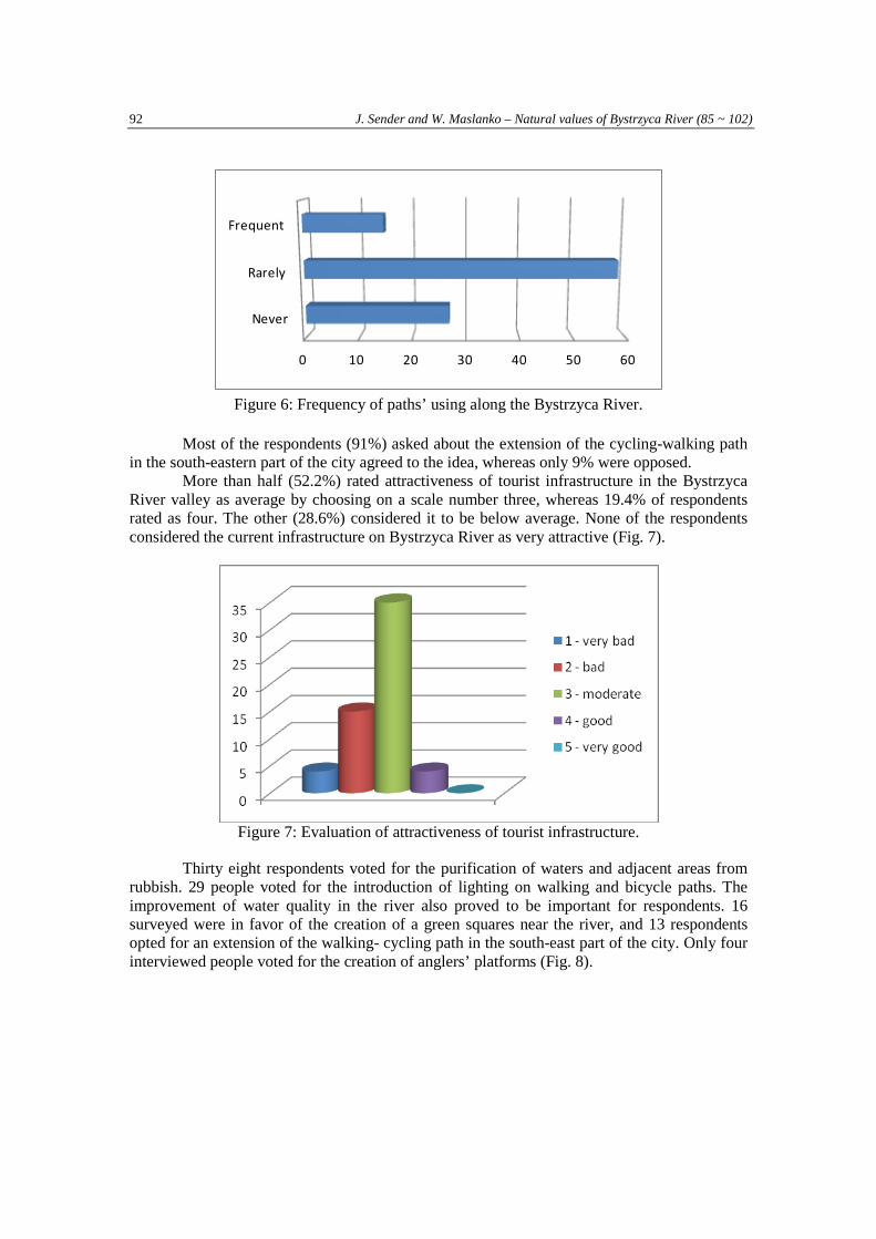
J. Sender and W. Maslanko – Natural values of Bystrzyca River (85 ~ 102) 92
0 10 20 30 40 50 60
Never
Rarely
Frequent
Figure 6: Frequency of paths’ using along the Bystrzyca River.
Most of the respondents (91%) asked about the extension of the cycling-walking path in the south-eastern part of the city agreed to the idea, whereas only 9% were opposed. More than half (52.2%) rated attractiveness of tourist infrastructure in the Bystrzyca River valley as average by choosing on a scale number three, whereas 19.4% of respondents rated as four. The other (28.6%) considered it to be below average. None of the respondents considered the current infrastructure on Bystrzyca River as very attractive (Fig. 7).
Figure 7: Evaluation of attractiveness of tourist infrastructure.
Thirty eight respondents voted for the purification of waters and adjacent areas from rubbish. 29 people voted for the introduction of lighting on walking and bicycle paths. The improvement of water quality in the river also proved to be important for respondents. 16 surveyed were in favor of the creation of a green squares near the river, and 13 respondents opted for an extension of the walking- cycling path in the south-east part of the city. Only four interviewed people voted for the creation of anglers’ platforms (Fig. 8).
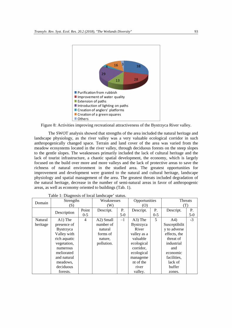
Transylv. Rev. Syst. Ecol. Res. 20.2 (2018), "The Wetlands Diversity" 93
38
2813
29
4 16 3
Purification from rubbishImprovement of water quality Extension of pathsIntroduction of lighting on pathsCreation of anglers' platforms Creation of a green squares Others
Figure 8: Activities improving recreational attractiveness of the Bystrzyca River valley.
The SWOT analysis showed that strengths of the area included the natural heritage and landscape physiology, as the river valley was a very valuable ecological corridor in such anthropogenically changed space. Terrain and land cover of the area was varied from the meadow ecosystems located in the river valley, through deciduous forests on the steep slopes to the gentle slopes. The weaknesses primarily included the lack of cultural heritage and the lack of tourist infrastructure, a chaotic spatial development, the economy, which is largely focused on the build over more and more valleys and the lack of protective areas to save the richness of natural environment in the studied area. The greatest opportunities for improvement and development were granted to the natural and cultural heritage, landscape physiology and spatial management of the area. The greatest threats included degradation of the natural heritage, decrease in the number of semi-natural areas in favor of anthropogenic areas, as well as economy oriented to buildings (Tab. 1).
Table 1: Diagnosis of local landscape’ status.
Domain Strengths (S)
Weaknesses (W)
Opportunities (O)
Threats (T)
Description Point 0-5
Descript. P. 5-0
Descript. P. 0-5
Descript. P. 5-0
Natural heritage
A1) The presence of Bystrzyca
Valley with rich aquatic vegetation, numerous meliorated and natural meadows, deciduous
forests.
4 A2) Small number of
natural forms of nature,
pollution.
‒1 A3) The Bystrzyca
River valley as a valuable
ecological corridor,
ecological management of the
river valley.
5 A4) Susceptibility to adverse effects, the
threat of industrial
and economic facilities, lack of buffer zones.
-3

J. Sender and W. Maslanko – Natural values of Bystrzyca River (85 ~ 102) 94
Table 1 (continued): Diagnosis of local landscape’ status.
Domain Strengths (S)
Weaknesses (W)
Opportunities (O)
Threats (T)
Description Point 0-5
Descript. P. 5-0
Descript. P. 0-5
Descript. P. 5-0
Cultural heritage
B1) There are no cultural facilities in
the study area except
roadside chapels.
1 B2) Lack of culturally valuable points.
‒3 B3) Possibility of creating
cultural centers,
enriching the natural heritage.
4 B4) The lack of
development of the area in terms of
cultural heritage.
-1
Society C1) The presence of
garden parcels and
bicycle paths promotes the integration of
society.
3 C2) Blocks mixed with single and compact
farmhouses, small
degree of integration.
‒2 C3) Develop-ment of enviro-nmental
awareness, tourism
and spatial-
functional order, which
improve the local
community
3 C4) Division of society, a
small degree of
integration, lack of
interest in environmen
tal problems.
-2
Spatial planning
D1) Expanded
road network, accessibility to services,
close proximity to
nature.
2 D2) Functional-
spatial disorder, dispersed
single-family
housing, dominance of buildings over natural environment lack of river’
and its adjoining
areas development
‒3 D3) Ecological and tourist development of the Bystrzyca
River valley
4 D4) Developme
nt of dispersed buildings and road
infrastructure, lack of
buffer zones protecting the river
valley from the
pollution.
-1

Transylv. Rev. Syst. Ecol. Res. 20.2 (2018), "The Wetlands Diversity" 95
Table 1 (continued): Diagnosis of local landscape’ status.
Domain Strengths (S)
Weaknesses (W)
Opportunities (O)
Threats (T)
Description Point 0-5
Descript. P. 5-0
Descript. P. 0-5
Descript. P. 5-0
Eco-nomy
E1) Expanded agricultural
and industrial service.
2 E2) A negative impact of
the developed
economy on the
ecological status of the
area (surface
runoff from fields,
littering, odors in the vicinity of
sewage treatment
plants, polluted
river waters).
‒3 E3) Intensifica
tion of ecological
and tourism
economy of the
examined area,
taking into account needs of the local
community
3 E4) Environmen
tal degradation, the lack of taking into account of
environmental
protection in the area
in economic development
-1
Land-scape
physio-logy
F1) The occurrence of
interesting forms of
terrain – river valley, isle
bergs, plateau gorge, and
land cover – flowing and
standing waters,
deciduous forests,
grasslands.
4 F2) The lack of
visibility of positive
characteri-stics of natural
landscape, overwhelm-
ed by anthropogenic elements, the lack of
positive aesthetic qualities.
‒2 F3) Creation
of protected areas to preserve
and enhance
the richness of animated
and inanimate
nature, afforestati
on, tree planting,
more attention to nature.
5 F4) Extrusion of
positive elements of nature with anthropogenic elements - bridges,
fast-moving roads,
buildings, which can cause even
more degradation
of the environmen
t.
-4

J. Sender and W. Maslanko – Natural values of Bystrzyca River (85 ~ 102) 96
Table 1 (continued): Diagnosis of local landscape’ status.
Domain Strengths (S)
Weaknesses (W)
Opportunities (O)
Threats (T)
Description Point 0-5
Descript. P. 5-0
Descript. P. 0-5
Descript. P. 5-0
Summa-ry
bonita-tion
16 ‒15 22 -12
Based on the results of the landscape status’ diagnosis, objectives that were desirable and achievable in the area have been identified (Tab. 2).
Table 2: Evaluation of targets implementation, choice and prioritizing. Evaluation of
implementation’ effects of the concept of land
planning development
Target I: Preservation of semi-natural character of
landscape and increase of ecological potential
of the Bystrzyca Valley
Target II: Development of cultural heritage
Target III: Increasing of
recreational and sporting
attractiveness
Influence on natural heritage
5 1 ‒1
Influence on cultural heritage
3 5 0
Society needs fulfilling 4 4 5 Effect on functional-
spatial order 3 2 3
Fulfilling the needs of the local community
4 4 5
Costs of achieving a target ‒3 ‒3 ‒5 Influence on the values of landscape physiognomy
5 2 1
Summary bonitation 21 14 11 Decision Priority realization Recommended
realization Recommended
realization As a priority, “target I” was chosen to preserve the semi-natural character of the landscape and increase an ecological potential of the Bystrzyca Valley, given its important ecological role in the area and great chances for development and improvement of the present status. The “target II” ‒ the development of cultural heritage in the studied area was included in the recommendations for the less favorable impact on the assessed aspects of the implementation effects of the land use concept. Likewise, “target III” – an increasing recreation and sport attractiveness, which could additionally have negative consequences in the form of degradation and pollution of the natural environment and high cost of implementation.

Transylv. Rev. Syst. Ecol. Res. 20.2 (2018), "The Wetlands Diversity" 97
Concepts of three variants implementing objectives combined activities aimed at achieving “target I” and elements of actions related to the implementation of “target III” in accordance with principles of sustainable development. The “target I” assumed creation of a park and plantation of dry-ground forest in the south-west part of the area, the extension of the bike path along the river, and the formation of a viewpoint (Fig. 9). The concept also presented opportunities for improving ecological conditions of the area by introducing filtering vegetation in the first and final sections of the river, creating oxygenation thresholds and subsoil to improve water quality in the river. It is also suggested to reconstruct aquatic vegetation and to create floodplains in valuable wetlands, as well as to create a protection zone to prevent further degradation and to create habitat conditions close to natural (Fig. 9). Another important element of the concept is introduction of small water bodies, midfield trees and bushes, which would greatly contribute to accumulation of biogenic substances and reduce their surface runoff into the watercourse and to improve water retention in the study area.
Figure 9: The “I variant” of functional-spatial structure.
As the best, “I variant” was considered because it influenced the most preferably on the evaluation of the effects of the concept and land development, mainly on the natural heritage, conditions of the area management, a landscape physiognomy and socio-economic effects (Tab. 3).
Borders of units Numbers of units Border of chosen unit
Introducing filtering vegetation Creation of oxygenation thresholds Creation of buffer zone Bushes Creation of subsoil Creation of floodplains Aquatic vegetation Plantation of dry-ground forest Creation of park Creation of protection zone Creation of walking – bicycle path Viewpoint Small water bodies Midfield trees

J. Sender and W. Maslanko – Natural values of Bystrzyca River (85 ~ 102) 98
Table 3: Variants’ impact on evaluated aspect of concepts’ realization and land planning development.
Evaluated aspect I variant II variant III variant Impact on natural values 5 4 3 Impact on cultural values 1 2 1 Impact on functional-spatial order 3 2 1 Impact on site management conditions 4 4 4 Implementation costs ‒2 ‒3 ‒3 Expected socio-economic effects 4 3 4 Impact on landscape physiognomy’ values 5 5 5 Summary bonitation 20 17 15
Decision Priority realization
Recommended realization
Recommended realization
DISCUSSION The motivation for the study was information about the local community’ needs in relation to the river valley located in the urbanized space and the essence and obligation of river valleys’ revitalization in accordance with the Act of the Minister of the Environment from 2016. River valleys are at the earliest used and transformed ecosystems. At present, revitalization – the main direction of development of cities in Poland, is seen as an opportunity for a new quality of a riverside urban space and improvement of functioning of river valleys in cities. These actions will contribute to improve living conditions and increase a tourism potential of cities (Bernat, 2013). The Bystrzyca River and its valley in Lublin are characterized by great potential for recreation, nature and landscape. Unfortunately, yet it is not used enough. The Bystrzyca Valley, as an ecological corridor, connects 12 ecological links of the ecological structure (forests, meadows, garden plots) with urbanized centre (Bernat, 2013). Water of the Bystrzyca River is characterized by IV class of water quality. The quality of inflow waters oscillated between III and IV class; in the city only Czechówka watercourse entered V class water (WIOŚ Lublin, 2005). River Valleys are considered to be extremely important areas, particularly in areas characterized by a high degree of anthropogenic transformation. In many cities a river valley contributes to one of the few open spaces with free air exchange and a specific microclimate (Bernat, 2013). In the settlement space river valleys are also elements of a social bond and concentration of inhabitants fulfilling their needs here: volatility and stability, silence and bustle, calm and movement, loneliness and community participation, anonymity and public appearances or individual expression of their personality (Wallis, 1971). Therefore, it is very important to familiarize with opinion and needs of the society and their direct participation in decision-making process. Inhabitants’ participation in environmental issues has a lot of positive aspects, e.g. promoting a connection between people and nature (Devictor et al., 2010; Hobbs and White, 2012) or raising awareness of environment (Brossard et al., 2005; Jones-Walters and Cil, 2011), what was underlined by many authors so far (Buchecker et al., 2003).

Transylv. Rev. Syst. Ecol. Res. 20.2 (2018), "The Wetlands Diversity" 99
One of the methods of participation of local community in public areas’ changes is to conduct a survey. It allows to anonymously expressing own feelings, desires, expectations or ideas. A questionnaire about the Bystrzyca Valley conducted in Lublin allowed to create a hierarchy of actions to be taken in this area. The priority for most respondents was not a creation of additional attractions and diversifies the site, but cleaning up and improvement of water quality. This not only proves the environmental consciousness of society, but also a fatal status of the environment that is noticeable even to the inexperienced observer. A large number of respondents also pointed to the need to light walking and bicycle paths, which indicates lack of security and draws attention to limiting use during rest of the year. A fact of local society’ participation in the development of the area, is also supported by city authorities. An example may be Piotrków Trybunalski city, where among inhabitants a survey was conducted, based on which the revitalization project was chosen. It was mainly based on the renewal of the Old Town, which in opinion of the most inhabitants had the greatest potential and chances to become a city symbol. The significance of society’ participation was emphasized by Czyżewska (2010). The basis for action was division into spatial units, relatively closed, composed from interconnected geocomponents or lower level systems, to carry out an analyze of the landscape structure (Richling, 1997). This process importance has been emphasized by Chmielewski (2013), because natural – landscape units (JPK) comprehensively map the structure of many individual components of the environment, providing reference systems for landscape research. Various scientific disciplines dealing with the landscape have worked out and applied different land division systems into basic natural spatial units. Among them are two basic, first supported by proponents of the concept of environmental continuity ‒ the division into units of natural boundaries, whereas the second one ‒ the division into artificial, geometric basic fields, applied uniformly and randomly to a map or political, administrative divisions, conducted due to economic premise or location of the population (Chmielewski, 2012). During assigning units based on natural boundaries, a various criteria depending on the type of landscape and the purpose of an analysis are accepted. By studying the fragment of the Bystrzyca Valley, a method of division into natural-landscape units based on boundaries of terrain and land cover form was applied. On this basis, the following types of landscape were distinguished: deciduous forests on gentle slopes, grassland meadows in river valley, compact farmland on steep slopes or greenery production on steep slopes. Designated units provided the basis for assessing the ecological potential of the area, its aesthetic value, and the potential for improvement and development of the area by introducing new facilities and functions. Natural ‒ landscape units were a base of Wyrzykowski (2000), who apart from land cover and terrain, took into account the degree of anthropogenic transformation. Balon and Krąż (2013) considered that criteria for separating units should differentiating a landscape: e.g. geological criteria (lithology and tectonics), or geomorphological criteria (terrain types). In the study natural boundaries of basins, patches, forests, rivers and buildings, without interrupting continuity in the landscape, were used to create natural – landscape units (JPK). As a result, an appropriate degree of homogeneity of the allocated landscape units has been achieved to facilitate further research and analysis. In similar analyzes various criteria of division were used, which means that the basic field can be extracted from any set of elements that simultaneously show directed and significant links from the perspective of the study area and occurring processes (Richling, 1997).
J. Sender and W. Maslanko – Natural values of Bystrzyca River (85 ~ 102) 100
Revitalization is a complex, often long-term process, which aims at giving a new quality to a degraded area. Revitalization is seen as an opportunity to improve the quality of urban riverside spaces, which should be natural and valuable public spaces (Domańska, 2012). The analyzed part of the Bystrzyca Valley is located in strongly transformed anthropogenic space, what makes it particularly sensitive to pollution and unfavorable transformations. Taking into account the great importance of such ecosystems in nature and many other important social functions, their proper management is high important. Presented in the work concept of development of the Bystrzyca Valley was based on sequential activities, including: land reconnaissance, study of terrain’ determinants, natural inventory, identification of user needs, establishment of conceptual guidelines and hierarchy of objectives and ways of achieving them and a choice of the most favorable concept for nature and society. Developed in that way concept primarily assumed improvement of the environment status and the quality of water in this area. Activities aimed at revitalization included: introduction of filtering vegetation, restoration of aquatic vegetation, creation of protected zone on adjacent areas, creation of floodplains, oxygenation thresholds, subterranean, small water bodies and midfield trees and bushes. CONCLUSIONS The analyzed part of the Bystrzyca River valley within the Lublin city provides a refuge of valuable natural habitats, which are overwhelmed by anthropogenic forms of land cover. The strengths of the area include large ecological potential and a variety of forms of land cover and terrain, whereas weaknesses – the lack of development of tourism and cultural heritage, a chaotic spatial development, as well as development of buildings. According to the respondents, the Bystrzyca Valley is not attractive to tourists, and its main reason is poor status of the natural environment. The conservation of the semi-natural character of the landscape and the enhancement of the ecological potential of the Bystrzyca Valley has been recognized as priority activities in the studied area. As the best variant fulfill a priority purpose, variant no. I was chosen. It concerns creation of floodplains, protection zone, improvement of water quality and creation of a walking ‒ bicycle path.
ACKNOWLEDGEMENTS Firstly, the authors would like to thank to Mrs. Curtean-Bănăduc A. and Mr. Bănăduc D., the editors of Transylvanian Review of Systematical and Ecological Research for their continuous support. Secondly, we would like to thank to students Marucha P. and Kuk M. for their great contribution in creation of this work.

Transylv. Rev. Syst. Ecol. Res. 20.2 (2018), "The Wetlands Diversity" 101
REFERENCES 1. Balon J. and Krąż P., 2013 ‒ Ocena jakości krajobrazu: dobór prawidłowych jednostek
krajobrazowych/Landscape quality assessment: selection of correct landscape units, in Identyfikacja i waloryzacja krajobrazów ‒ wdrażanie Europejskiej Konwencji Krajobrazowej, Generalna Dyrekcja Ochrony Środowiska, Warszawa, 58-63. (in Polish)
2. Benton T. G., Vickery J. A. and Wilson J. D., 2003 ‒ Farmland biodiversity: is habitat heterogeneity the key? Trends in Ecology and Evolution, 18, 182-188.
3. Bernat S., 2010 ‒ Doliny rzeczne i ich percepcja, Krajobrazy kulturowe dolin rzecznych, potencjał i wykorzystanie/River valleys and their perception, Cultural landscapes of river valleys, potential and use, Prace Komisji Krajobrazu Kulturowego PTG, Sosnowiec, 13, 167-178. (in Polish)
4. Bernat S., 2013 ‒ Atrakcyjność turystyczno-rekreacyjna dolin rzecznych a ich rewitalizacja na przykładzie doliny Bystrzycy w Lublinie/Tourism and recreation attractiveness of river valleys and their revitalization on the example of Bystrzyca Valley in Lublin, Problemy Rozwoju Miast, 10, 2, 41-52. (in Polish)
5. Brossard D., Lewenstein B. and Bonney R., 2005 ‒ Scientific knowledge and attitude change: The impact of a citizen science project, International Journal of Science Education, 27, 1099-1121.
6. Buchecker M., Hunziker M. and Kienast F., 2003 ‒ Participatory landscape development: overcoming social barriers to public involvement, Landscape and Urban Planning, 64, 29-46.
7. Bullock A. and Acreman M., 2003 ‒ The role of wetlands in the hydrological cycle, Hydrology and Earth System Sciences Discussions, 7, 3, 358-389.
8. Chmielewski T. J., 2013 ‒ Standardy i wskaźniki jakości krajobrazu, Identyfikacja i waloryzacja krajobrazów ‒ wdrażanie Europejskiej Konwencji Krajobrazowej/Standards and indicators of landscape quality, Identification and valorisation of landscapes ‒ implementation of the European Landscape Convention, GDOŚ, Warszawa, 43-57. (in Polish)
9. Chmielewski T. J., 2012 ‒ Systemy krajobrazowe: struktura, funkcjonowanie, planowanie/Landscape systems: structure, functioning, planning, Wydawnictwo Naukowe PWN, Warszawa, 408. (in Polish)
10. Crooks K. R., Suarez A. V. and Bolger D. T., 2004 ‒ Avian assemblages along a gradient of urbanization in a highly fragmented landscape, Biological Conservation, 115, 451-462.
11. Czyżewska A., 2010 ‒ Jak planować proces rewitalizacji społeczno-gospodarczej przestrzeni miejskiej?/How to plan the process of revitalization of socio-economic urban space? Pracowania Badań i Innowacji Społecznych, Stocznia, 1-18. (in Polish)
12. Devictor V., Whittaker R. J. and Beltrame C., 2010 ‒ Beyond scarcity: Citizen science programmes as useful tools for conservation biogeography, Diversity and Distribution, 16, 354-362.
13. Diamond J. M., Terborgh J., Whitcomb R. F., Lynch J. F. and Opler P. A., 1976 ‒ Island biogeography and conservation: Strategy and limitations, Science, 193, 1027-1032.
14. Domańska J., 2012 ‒ Przyszłość dolin rzecznych w miastach/Future of river valleys in cities, Czasopismo Techniczne, Architektura, 1, 1, 131-139. (in Polish)
15. Erwin K. L., 2009 ‒ Wetlands and global climate change: the role of wetland restoration in a changing world, Wetlands Ecology and Management, 17, 1, 71-84.
16. Izydorczyk K., Frątczak W., Drobniewska A., Badowska M. and Zalewski M., 2010 ‒ Zastosowanie stref ekotonowych w ograniczaniu zanieczyszczeń obszarowych/Application of ecotone zones to reduce area pollution, Przegląd Komunalny, 10, 79-81. (in Polish)
17. Fahrig L., 2003 ‒ Effects of habitat fragmentation on biodiversity, Annual Review of Ecology Evolution and Systematics, 34, 487-515.
18. Hobbs S. J., Piran C. L. and White P. C. L., 2012 ‒ Motivations and barriers in relation to community participation in biodiversity recording, Journal for Nature Conservation, 20, 364-373.

J. Sender and W. Maslanko – Natural values of Bystrzyca River (85 ~ 102) 102
19. Kerr J. T. and Deguise I., 2004 ‒ Habitat loss and the limits to endangered species recovery,Ecology Letters, 7, 1163-1169.
20. Kijowski A. and Rączkowski W., 2007 ‒ Przekształcenia w sieci osadniczej dolin rzecznych wWielkopolsce i ich rola w planowaniu przestrzennym/Transformations in the settlement networkof river valleys in Wielkopolska and their role in spatial planning, Doliny rzeczne, przyroda-krajobraz-człowiek, PTG, Sosnowiec, 7, 301-311. (in Polish)
21. Jones-Walters L. and Cil A., 2011 ‒ Biodiversity and stakeholder participation, Journal forNature Conservation, 19, 327-329.
22. Lipka K. and Stabryła J., 2012 ‒ Wielofunkcyjność mokradeł w Polsce iświecie/Multifunctionality of wetlands in Poland and around the world, Współczesne ProblemyKształtowania i Ochrony, Monografie 3, 7-16. (in Polish)
23. Luck G. W., Ricketts T. H., Daily G. C. and Imhoff M., 2004 ‒ Alleviating spatial conflictbetween people and biodiversity, Proceedings of the National Academy of Sciences of the UnitedStates of America, 101, 182-186.
24. MacArthur R. H. and Wilson E. O., 1967 ‒ The theory of island biogeography ‒ Monographs inpopulations biology, 1, Princeton University Press, Princeton, New Jersey, 203.
25. Matuszkiewicz J., Solon J., Roo-Zielińska E., Kowalska A. and Romanowski J., 2007 ‒Zastosowanie scenariuszy ekologicznych dla poprawy partycypacji społecznej w planowaniuprzestrzennym/Application of ecological scenarios to improve social participation in spatialplanning, Urbanista 5, 53, 18-24. (in Polish)
26. Matuszkiewicz J. M., 1999 ‒ Prognozy i waloryzacje przyrodnicze skutków różnych wariantówzagospodarowania hydrotechnicznego Wisły/Forecasts and valorisation of natural effects ofdifferent variants of the Vistula River’ hydrotechnical development, (w:) M. Kucharczyk (ed.) inProblemy ochrony i renaturalizacji dolin dużych rzek Europy. Materiały MiędzynarodowejKonferencji z okazji 20-lecia Kazimierskiego Parku Krajobrazowego, Lublin: Wydaw. UMCS,165-172. (in Polish)
27. Plit J., 2008 – Zarzadzanie krajobrazem dolin rzecznych/Management of the landscape of rivervalleys, Zarządzanie krajobrazem kulturowym, przyroda-krajobraz-człowiek, PTG, Sosnowiec,10, 230-240. (in Polish)
28. Richling A., 1997 ‒ Problemy Ekologii Krajobrazu/Problems of Landscape Ecology,Wydawnictwo Paek, Kraków. (in Polish)
29. Sala O. E., Chapin F. S., Armesto J. J., Berlow E., Bloomfield J., Dirzo R., Huber-Sanwald E.,Huenneke L. F., Jackson R. B., Kinzig A., Leemans R., Lodge D. M., Mooney H. A., OesterheldM., Poff N. L., Sykes M. T., Walker B. H., Walker M. and Wall D. H., 2000 ‒ Globalbiodiversity scenarios for the year 2100, Science, 287, 1770-1774.
30. Wyrzykowski J., 2000 ‒ Conditions of the foreign tourism in the Central and Eastern Europe, inWyrzykowski J. (ed.) Changes in model of tourism in the last decade, Wrocław, ZakładGeografii Regionalnej i Turystyki, 93-112.
31. Wallis A., 1971 ‒ Socjologia i kształtowanie przestrzeni/Sociology and space shaping, PIWWarszawa, 1-228. (in Polish)
32. Water Framework Directive 2000/60/EC, 2000.33. Wilcove D. S., Rothstein D., Dubow J., Phillips A. and Losos E., 1998 ‒ Quantifying threats to
imperiled species in the United States, Bioscience, 48, 607-615.34. Żelazo J., 2006 ‒ Renaturalizacja rzek i dolin/Renaturalization of rivers and valleys,
Infrastruktura i ekologia terenów wiejskich, 4, 1, 11-31. (in Polish)