Historic tsunami in Britain since AD 1000: a review
15
Nat. Hazards Earth Syst. Sci., 8, 587–601, 2008 www.nat-hazards-earth-syst-sci.net/8/587/2008/ © Author(s) 2008. This work is distributed under the Creative Commons Attribution 3.0 License. Natural Hazards and Earth System Sciences Historic tsunami in Britain since AD 1000: a review S. K. Haslett 1,* and E. A. Bryant 2 1 Quaternary Research Centre, Department of Geography, School of Science and the Environment, Bath Spa University, Newton Park, Bath, BA2 9BN, UK 2 Science Faculty Office, University of Wollongong, Wollongong, NSW 2522, Australia * present address: CELT, UniversityofWales, Newport, Lodge Road, Caerleon, South Wales, NP18 3QT, UK Received: 26 February 2008 – Revised: 4 June 2008 – Accepted: 4 June 2008 – Published: 30 June 2008 Abstract. The British coast is not considered at particu- lar risk from tsunami, a view that is supported by a num- ber of recent government reports. However, these reports largely ignore some written historic records that suggest southern Britain has experienced a number of events over the past 1000 yrs. This study briefly assesses these records and recognises four groups of events: 1) sea disturbance and coastal floods in southeast England linked to earthquakes in the Dover Straits (e.g. 1382 and 1580), 2) far-field tsunami reaching the coast of the British Isles, for example, from earthquakes along the Azores-Gibraltar Fault Zone offshore Portugal (e.g. 1755), 3) tsunami associated with near-coastal low magnitude earthquakes (e.g. 1884 and 1892), and 4) a flood event in AD 1014 that has been linked to comet de- bris impact. The seismogenic events range from minor wa- ter disturbance, through seismic seiching, to small and “gi- ant” waves, suggesting near-coastal, low-magnitude, shallow earthquakes may be capable of triggering disturbance in rel- atively shallow water, as supported by similar occurrences elsewhere, and that the British tsunami risk requires a more careful evaluation. 1 Introduction The coast of the British Isles has not been considered to be particularly at risk from the impact of tsunami. Nevertheless, in the aftermath of the Indian Ocean tsunami of 2004, a study commissioned by the Department of Environment, Food and Rural Affairs (DEFRA, 2005) evaluated the threat posed by Correspondence to: S. K. Haslett ([email protected]) tsunami to the UK. The study concluded that, despite their stated view that UK seismicity “is of no possible relevance to tsunami hazard” (p. 9), “the most likely scenario for a sig- nificantly damaging tsunami in the UK is an anomalously large . . . earthquake . . . that would only be severe locally . . . and even should such an event [earthquake] occur, it is prob- able that it would not produce a tsunami” (DEFRA, 2005, p. 3). The study does acknowledge the potential risk from a North Sea earthquake (similar to the 1931 Dogger Bank earthquake; see also DEFRA, 2006), a passive margin earth- quake in the Celtic Sea region, a Storegga slide-type event (Smith et al., 2005), an earthquake on the Azores-Gibraltar fracture zone (similar to the 1755 Lisbon earthquake; Foster et al., 1991; Dawson et al., 2000; DEFRA, 2006), and flank failure of Canary Island volcanoes (e.g. Masson, 1996; Ward and Day, 2001). DEFRA (2005) do evaluate and discount the recent theory proposing the catastrophic Bristol Channel flood of 1607– in which it is thought 2000 people died–was caused by a tsunami (Bryant and Haslett, 2003, 2007; Haslett and Bryant, 2005, 2007a) rather than a storm (Horsburgh and Horritt, 2006). However, the tsunami risk in Britain is not considered beyond a few events (e.g. 1580, 1755, and 1931 earthquakes). The aim of this paper is to briefly assess written historic ac- counts that suggest a number of additional tsunami-like oc- currences in Britain over the last 1000 yrs. Recently, an earthquake occurred along the English Chan- nel coast, with its epicentre at Folkestone in Kent, at 8.28 a.m. (local time) on 28 April 2007. The local earthquake magnitude was estimated by the British Geological Survey as 4.2 M L (Walker and Musson, 2007) and no discernable affect was reported on the sea. However, worryingly, a lo- cal news outlet reported that coastal residents on feeling the tremor “started rushing out from their houses and on to the Published by Copernicus Publications on behalf of the European Geosciences Union.
Transcript of Historic tsunami in Britain since AD 1000: a review

Nat. Hazards Earth Syst. Sci., 8, 587–601, 2008www.nat-hazards-earth-syst-sci.net/8/587/2008/© Author(s) 2008. This work is distributed underthe Creative Commons Attribution 3.0 License.
Natural Hazardsand Earth
System Sciences
Historic tsunami in Britain since AD 1000: a review
S. K. Haslett1,* and E. A. Bryant2
1Quaternary Research Centre, Department of Geography, School of Science and the Environment, Bath Spa University,Newton Park, Bath, BA2 9BN, UK2Science Faculty Office, University of Wollongong, Wollongong, NSW 2522, Australia* present address: CELT, University of Wales, Newport, Lodge Road, Caerleon, South Wales, NP18 3QT, UK
Received: 26 February 2008 – Revised: 4 June 2008 – Accepted: 4 June 2008 – Published: 30 June 2008
Abstract. The British coast is not considered at particu-lar risk from tsunami, a view that is supported by a num-ber of recent government reports. However, these reportslargely ignore some written historic records that suggestsouthern Britain has experienced a number of events overthe past 1000 yrs. This study briefly assesses these recordsand recognises four groups of events: 1) sea disturbance andcoastal floods in southeast England linked to earthquakes inthe Dover Straits (e.g. 1382 and 1580), 2) far-field tsunamireaching the coast of the British Isles, for example, fromearthquakes along the Azores-Gibraltar Fault Zone offshorePortugal (e.g. 1755), 3) tsunami associated with near-coastallow magnitude earthquakes (e.g. 1884 and 1892), and 4) aflood event in AD 1014 that has been linked to comet de-bris impact. The seismogenic events range from minor wa-ter disturbance, through seismic seiching, to small and “gi-ant” waves, suggesting near-coastal, low-magnitude, shallowearthquakes may be capable of triggering disturbance in rel-atively shallow water, as supported by similar occurrenceselsewhere, and that the British tsunami risk requires a morecareful evaluation.
1 Introduction
The coast of the British Isles has not been considered to beparticularly at risk from the impact of tsunami. Nevertheless,in the aftermath of the Indian Ocean tsunami of 2004, a studycommissioned by the Department of Environment, Food andRural Affairs (DEFRA, 2005) evaluated the threat posed by
Correspondence to:S. K. Haslett([email protected])
tsunami to the UK. The study concluded that, despite theirstated view that UK seismicity “is of no possible relevanceto tsunami hazard” (p. 9), “the most likely scenario for a sig-nificantly damaging tsunami in the UK is an anomalouslylarge . . . earthquake . . . that would only be severe locally . . .and even should such an event [earthquake] occur, it is prob-able that it would not produce a tsunami” (DEFRA, 2005,p. 3). The study does acknowledge the potential risk froma North Sea earthquake (similar to the 1931 Dogger Bankearthquake; see also DEFRA, 2006), a passive margin earth-quake in the Celtic Sea region, a Storegga slide-type event(Smith et al., 2005), an earthquake on the Azores-Gibraltarfracture zone (similar to the 1755 Lisbon earthquake; Fosteret al., 1991; Dawson et al., 2000; DEFRA, 2006), and flankfailure of Canary Island volcanoes (e.g. Masson, 1996; Wardand Day, 2001).
DEFRA (2005) do evaluate and discount the recent theoryproposing the catastrophic Bristol Channel flood of 1607–in which it is thought 2000 people died–was caused by atsunami (Bryant and Haslett, 2003, 2007; Haslett and Bryant,2005, 2007a) rather than a storm (Horsburgh and Horritt,2006). However, the tsunami risk in Britain is not consideredbeyond a few events (e.g. 1580, 1755, and 1931 earthquakes).The aim of this paper is to briefly assess written historic ac-counts that suggest a number of additional tsunami-like oc-currences in Britain over the last 1000 yrs.
Recently, an earthquake occurred along the English Chan-nel coast, with its epicentre at Folkestone in Kent, at8.28 a.m. (local time) on 28 April 2007. The local earthquakemagnitude was estimated by the British Geological Surveyas 4.2 ML (Walker and Musson, 2007) and no discernableaffect was reported on the sea. However, worryingly, a lo-cal news outlet reported that coastal residents on feeling thetremor “started rushing out from their houses and on to the
Published by Copernicus Publications on behalf of the European Geosciences Union.

588 S. K. Haslett and E. A. Bryant: Historic tsunami of Britain
beach for safety” (Kent News, 2007)! This highlights theneed to assess the threat from tsunami and associated haz-ards in Britain and, if appropriate, raise public awareness ofthe potential hazards.
2 Tsunami-like Events
Based upon definitions posted on the websites of NOAA,the International Tsunami Information Center (ITIC), and thePacific Tsunami Warning Center (PTWC), a tsunami can bedefined as a wave, or series of waves in a wave train, gen-erated by the sudden, vertical displacement of a column ofwater. This displacement can be due to seismic activity, ex-plosive volcanism, impulsive ground movement, landslidesabove or below water, an asteroid impact, or certain meteo-rological phenomena (Bryant, 2001). A tsunami can be gen-erated in oceans, bays, lakes, rivers, or reservoirs. Eventssince AD 1000 have been selected for inclusion in the presentstudy if there is a link between sea disturbance and/or flood-ing and a source (e.g. earthquake, comet). For this reason,catastrophic flooding events without an obvious source, suchas the 1607 flood (Bryant and Haslett, 2003, 2007) and someother “non-tsunami” events catalogued by Long and Wil-son (2007) e.g. 1759, 1811, 1843, 1859, 1869, have beenomitted. Although we fully appreciate that historical docu-ments may mis-report, exaggerate or even invent accounts,we have adopted an inclusive, but not uncritical, approachto the use of historic evidence in the first instance, so as notto dismiss material before it can be openly discussed. It isalso appreciated that second-hand sources are likely to beless reliable than first-hand contemporary accounts and sothese have been used wherever possible. It is not the pur-pose of this paper to present a new catalogue consistent informat with the New European Tsunami Catalogue, but onlyto present observational material that may support the futureconstruction of such a catalogue. Figure 1 shows the loca-tions of places mentioned in the text, and Table 1 summarisesthe events reviewed.
2.1 Dover Straits events
Davison (1924) presents contemporary accounts, includingHolinshed (1587), of a strong earthquake with an estimatedlocal magnitude, ML, of 5.75±0.25 (Varley, 1996) that oc-curred on the 21 May 1382, which “was so vehement, andnamelie in Kent, that the churches were shaken therewithin such wise, that some of them were ouerthrowen to theground” (Holinshed, 1808, p. 754). There was then a secondevent on the 24 May when “earlie in the morning, chancedanother earthquake, or (as some write) a watershake, beingso vehement and violent a motion, that it made the ships inthe havens to beat one against the other, by reason whereofthey were sore bruised by such knocking together” (Holin-shed, 1808, p. 754). Melville (1982), citing the contemporary
Chroniclesof Henry Knighton (Martin, 1995), which is oneof the sources undoubtedly used by Holinshed (1587), de-scribes the event “as a water quake, which caused the shipsin the ports to shake from the movement of the waves”(Melville, 1982, p. 131). The event of the 24 May occurredclose to the time of predicted high tide at 09:52 GMT on themorning in question (Table 1). The direct link here betweena seismic event and hazardous sea conditions in early sum-mer, suggests that the sea was affected by seismic activity atthis time, manifested either as a small tsunami or seichingwithin harbours. The intensity of this second earthquake isuncertain but was as strong as, or locally stronger than, thefirst (Melville et al., 1996).
Holinshed (1587) recounts another “watershake” at the ar-rival of Empress Anne of Bohemia in Dover, who was tolater marry King Richard II, “where at hir landing, a maru-elous and right strange woonder happened; for she was nosooner out of hir ship, and got to land in safetie with allhir companie, but that foorthwith the water was so troubledand shaken, as the like thing had not to any mans remem-brance euer beene heard of: so that the ship in which theappointed queene came ouer, was terrible rent in peeces, andthe residue so beaten one against an other, that they werescattered here and there after a wonderful manner” (Holin-shed, 1808, p. 753). Although the date of Anne’s landing atDover is given as 18 December 1381 in theDictionary of Na-tional Biography(Gairdner, 1975), Lowes (1904) in examin-ing a contemporary account in Thomas Walsingham’sHis-toria Anglicanastates that the event “is not definitely statedby Walsingham to have been due to a storm of wind” andthat it “was probably the result of an earthquake” (p. 242).Moreover, Lowes (1908) gives the general impression fromhis reading of contemporary sources that the event was seento be “a strange and unprecedented disturbance of the sea”(p. 289). Although occurring within a general period of seis-mic activity in the area, there is no record of an earthquakeassociated with this event leaving its origin somewhat enig-matic.
An earthquake certainly occurred later in the EnglishChannel on 23 April 1449 and caused “boats [to be] rockedup and down” and it is claimed “the sinking of many ships” inBelgium, but appears not to have affected southeast England(Melville et al., 1996, p. 633). Other than this, however, lit-tle appears to be known about the circumstances of the eventand the magnitude of the earthquake.
Two large earthquakes occurred 12 h apart on 6 and 7April 1580 affecting a large area of southeast England, north-east France and Belgium (Mansergh, 1891), and were prob-ably generated along the Kent-Artois shear zone beneath theEnglish Channel. The earthquakes had an estimated localmagnitude, ML, of 5.8 (Musson, 1994, 2003). An unusualfeature of the first event is the duration of ground shaking,with contemporary accounts estimating from six or sevenminutes (Melville, 1981) to eight minutes (Ellart and Vion,1991), and in places three or four ground waves were seen
Nat. Hazards Earth Syst. Sci., 8, 587–601, 2008 www.nat-hazards-earth-syst-sci.net/8/587/2008/

S. K. Haslett and E. A. Bryant: Historic tsunami of Britain 589
Fig. 1. Locations of places mentioned in the text.
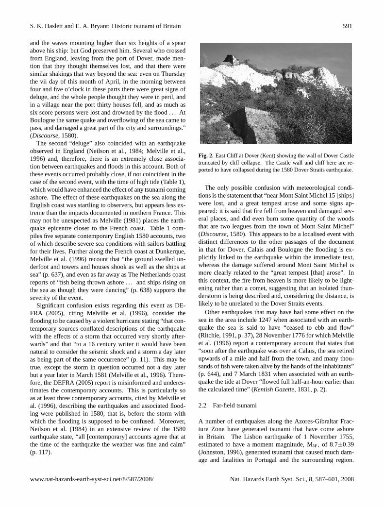
propagating across the landscape like “waves in the water,rolling forwards” (Melville, 1981, p. 373). Such shaking wascapable of initiating landslides as exemplified at Dover wherea section of Chalk cliff collapsed into the sea taking with itpart of Dover castle (Fig. 2; Melville, 1981; Melville et al.,1996).
A number of large tsunami (“giant waves” or seismicsea-waves as described by some authors) were apparentlyproduced that proved very destructive and possibly causedseveral hundred fatalities (Melville, 1981; Ambraseys andMelville, 1983; Neilson et al., 1984; Varley, 1996). A newtranslation of a contemporary French account presented herestates:
“Now to come to the marvellous things which have oc-curred in this month of April, one thousand five hundred andeighty, on the sixth and seventh day, I can assure you that inthe city of Calais such a horrible and terrible earthquake didcome to pass that a great part of the houses fell, and eventhe sea overflowed into the city and did ruin and drown agreat number of houses, and numerous persons perished, anda great multitude of beasts lost which were at pasture out-side this city. Mention hath been made of several ships thatperished by the great and awful tempestuousness of the sea,which number up to twenty-five, or thirty, French, Englishand Flemish vessels, and this was done between Calais andDover. One passenger that came from Dover to Calais re-lates that his ship did touch the bottom of the sea five times,
www.nat-hazards-earth-syst-sci.net/8/587/2008/ Nat. Hazards Earth Syst. Sci., 8, 587–601, 2008
590 S. K. Haslett and E. A. Bryant: Historic tsunami of Britain
Table 1. Summary of events reviewed. GMT=Greenwich Mean Time (Myers, 2007); HW=high water.1Tidal predictions supplied by theUK Hydrographic Office.
Date and Time(Julian and[Gregorian])
Tsunami Source Time of nearest high tide(s) (andheight, m above Chart Datum)1
Areas affected Deaths (in Britain) Other impacts
28 September [8 October] 1014 Comet impact (?) Dover, 8 October: HW 01:27 (6.6 m)and 13:50 (6.5 m) GMT
Kent, Sussex, Hampshire,Cornwall, Cumbria (?)
unknown, but reference todrowning throughout area
“submerge villages many miles inlan” William ofMalmesbury (Mynors et al.,1998)
Dover, 9 October: HW 02:10 (6.3 m)GMT
“ran so far up as it never did before, overwhelm-ing many towns” Anglo-Saxon Chronicle (Ingram,1823)
Penzance (Newlyn), 8 October: HW07:21 (5.2 m) and 19:40 (5 m) GMT
“inundated by a “mickle seaflood” when manytowns and people were drowned” (Saundry, 1936)
Whitehaven (Cumbria), 8 October:HW 02:06 (7.6 m) and 14:28 (7.5 m);9 October: 02:52 (7.3 m)
“much people and cattle lost” (Meldola and White,1885)
1247 earthquake Kent None known the sea is said to have “ceased to ebb and flow”(Ritchie, 1991, p. 37)
18 [26] December 1381 unknown Kent None known Ships destroyed at the port of Dover
24 May [3 June] 1382, morninglocal time
5.75±0.25 ML earthquake, proba-bly in the English Channel
Dover, 3 June: HW 09:52 (6.3 m)GMT
Kent unknown “ships in the havens to beat one against the other”(Holinshed, 1587)“ships in harbour were tossed by the shock”Knighton’s Chronicle (Martin, 1995,p. 243).
23 April [2 May] 1449 earthquake English Channel None known “boats rocked up and down” (Melville et al., 1996,p. 633)“the sinking of many ships” (Melville et al., 1996,p. 633)
6 & 7 [16 & 17] April 1580, ca.4.30 p.m. and 4.30 a.m. localtime respectively
5.8 ML earthquakes in the EnglishChannel
Dover, 16 April: HW 15:25 (5.7 m)GMT
Kent and northeast coastFrance
120 at Dover, but other inFrance
See text for French accounts.
Dover, 17 April: HW 04:12 (5.5 m)GMT
165 ships sank, presumablywith loss of life
“The ships quaked and trembled as the houses ondrye land, and the waters were greatly out of tem-per” (Munday, 1580, p. 32)“The shippes in the seae, as also such as weare atthe keye and wythin the havon at the beacons, feltethe lyke [earthquake]” (Boys, 1792, p. 696)“even the sea was thrown into such turbulencethat sailors cleaving the main feared submergenceforthwith” Registrum Annalium Collegii Merto-nensis, 1567–1603 (Melville et al., 1996, p. 67)“the land not onlie quaked, but the sea alsofomed, so that the ships tottered” (Holinshed,1808, p. 426)“at the same instant of time [as the earthquake], as’twas generally supported, the sea was so muchtossed and troubled, that the Mariners expectedsudden destruction” (Wood, 1796, p. 199)
1 November 1755 8.7 Mw magnitude earthquake,Azores-Gibraltar Fracture Zone
See Dawson et al. (2000) Atlantic-coast of Europe,southwest Britain, EnglishChannel, southern NorthSea, Ireland.
None known in southernBritain.
No details known from southern Britain.
31 March 1761, ca. 5 p.m. 7.5 Ms earthquake, offshore Portu-gal
Penzance,Cornwall: HW 13:36 (4.1 m) GMT
Atlantic-coast of Europe,southwest Britain, Ireland
None A succession of waves observed in Mounts Bay,Cornwall
28 November 1776 earthquake Calais, northeast France None known The sea withdrew at Calais
9/10 August 1802 Distant earthquake (?) Dorset and Devon None 0.35 and 0.6 m high at Weymouth and Teignmouthrespectively
7 March 1831 Earthquake Kent None the tide at Dover “flowed full half-an-hour earlierthan the calculated time” (Kentish Gazette, 1831,p. 2)
23 May 1847, all day and evening Earthquake, near Isles of Scilly (?) Devon and Cornwall None Waves up to 1.5 m came ashore
21 October 1859 4.0 ML earthquake, offshore North Cornwall Cornwall and Devon None Local water disturbance
22 April 1884, 09:18 a.m. GMT 4.6 – 5.5 ML earthquake, epicentrenear Colchester, Essex
Brightlingsea, Essex: HW09:15 (4.3 m) GMT
Suffolk, Essex, Thames,north Kent
None known, althoughmany injuries
boats shaken, up to 1 m high wave in the Colneand Thames estuaries
Margate, Kent: HW 09:15 (4.3m)GMT
bottom sediments disturbed
London Bridge: HW 10:58 (6.2m)GMT
18 August 1892, 0.24am GMT 5.1 ML earthquake, epicentre off-shore south Pembrokeshire
Milford Haven: HW 02:05 (5.4 m)GMT
Pembrokeshire, but earth-quake felt as far afield asSurrey, the Isles of Scilly,Rhyl (North Wales), and Car-low (southern Ireland)
None three tsunami progressed up Milford Haven
24 January 1927, 05:30 a.m.GMT
5.7 ML earthquake, VikingGraben (North Sea)
Eastern Scotland None Tyrell (1932) reports that “at the time of the shockthe bar at the mouth of the Helmsdale River [ineastern Scotland] was calm, but at 5.30am greatrollers began to come in from the south-east”.
25 November 1941 8.2 Ms earthquake, offshore Portu-gal
English Channel None 0.2 m high on Newlyn (Cornwall) tide gauge, andregistered at Le Havre (France)
24 May 1960 9.6 Mw earthquake, offshore Chile Cornwall None Registered on Newlyn (Cornwall) tide gauge
28 February 1969 7.3 Ms earthquake, offshore Portu-gal
Cornwall None Heavy seiching at Newlyn, Cornwall
26 May 1975 7.9 Ms earthquake, offshore Portu-gal
Cornwall None 0.06 m high on Newlyn (Cornwall) tide gauge
27 December 2004 9.3 Mw earthquake, offshoreSumatra
English Channel None Registered on tide gauges in the English Channeland possibly Milford Haven
Nat. Hazards Earth Syst. Sci., 8, 587–601, 2008 www.nat-hazards-earth-syst-sci.net/8/587/2008/
S. K. Haslett and E. A. Bryant: Historic tsunami of Britain 591
and the waves mounting higher than six heights of a spearabove his ship: but God preserved him. Several who crossedfrom England, leaving from the port of Dover, made men-tion that they thought themselves lost, and that there weresimilar shakings that way beyond the sea: even on Thursdaythe vii day of this month of April, in the morning betweenfour and five o’clock in these parts there were great signs ofdeluge, and the whole people thought they were in peril, andin a village near the port thirty houses fell, and as much assix score persons were lost and drowned by the flood . . . AtBoulogne the same quake and overflowing of the sea came topass, and damaged a great part of the city and surroundings.”(Discourse, 1580).
The second “deluge” also coincided with an earthquakeobserved in England (Neilson et al., 1984; Melville et al.,1996) and, therefore, there is an extremely close associa-tion between earthquakes and floods in this account. Both ofthese events occurred probably close, if not coincident in thecase of the second event, with the time of high tide (Table 1),which would have enhanced the effect of any tsunami comingashore. The effect of these earthquakes on the sea along theEnglish coast was startling to observers, but appears less ex-treme than the impacts documented in northern France. Thismay not be unexpected as Melville (1981) places the earth-quake epicentre closer to the French coast. Table 1 com-piles five separate contemporary English 1580 accounts, twoof which describe severe sea conditions with sailors battlingfor their lives. Further along the French coast at Dunkerque,Melville et al. (1996) recount that “the ground swelled un-derfoot and towers and houses shook as well as the ships atsea” (p. 637), and even as far away as The Netherlands coastreports of “fish being thrown ashore . . . and ships rising onthe sea as though they were dancing” (p. 638) supports theseverity of the event.
Significant confusion exists regarding this event as DE-FRA (2005), citing Melville et al. (1996), consider theflooding to be caused by a violent hurricane stating “that con-temporary sources conflated descriptions of the earthquakewith the effects of a storm that occurred very shortly after-wards” and that “to a 16 century writer it would have beennatural to consider the seismic shock and a storm a day lateras being part of the same occurrence” (p. 11). This may betrue, except the storm in question occurred not a day laterbut a year later in March 1581 (Melville et al., 1996). There-fore, the DEFRA (2005) report is misinformed and underes-timates the contemporary accounts. This is particularly soas at least three contemporary accounts, cited by Melville etal. (1996), describing the earthquakes and associated flood-ing were published in 1580, that is, before the storm withwhich the flooding is supposed to be confused. Moreover,Neilson et al. (1984) in an extensive review of the 1580earthquake state, “all [contemporary] accounts agree that atthe time of the earthquake the weather was fine and calm”(p. 117).
Fig. 2. East Cliff at Dover (Kent) showing the wall of Dover Castletruncated by cliff collapse. The Castle wall and cliff here are re-ported to have collapsed during the 1580 Dover Straits earthquake.
The only possible confusion with meteorological condi-tions is the statement that “near Mont Saint Michel 15 [ships]were lost, and a great tempest arose and some signs ap-peared: it is said that fire fell from heaven and damaged sev-eral places, and did even burn some quantity of the woodsthat are two leagues from the town of Mont Saint Michel”(Discourse, 1580). This appears to be a localised event withdistinct differences to the other passages of the documentin that for Dover, Calais and Boulogne the flooding is ex-plicitly linked to the earthquake within the immediate text,whereas the damage suffered around Mont Saint Michel ismore clearly related to the “great tempest [that] arose”. Inthis context, the fire from heaven is more likely to be light-ening rather than a comet, suggesting that an isolated thun-derstorm is being described and, considering the distance, islikely to be unrelated to the Dover Straits events.
Other earthquakes that may have had some effect on thesea in the area include 1247 when associated with an earth-quake the sea is said to have “ceased to ebb and flow”(Ritchie, 1991, p. 37), 28 November 1776 for which Melvilleet al. (1996) report a contemporary account that states that“soon after the earthquake was over at Calais, the sea retiredupwards of a mile and half from the town, and many thou-sands of fish were taken alive by the hands of the inhabitants”(p. 644), and 7 March 1831 when associated with an earth-quake the tide at Dover “flowed full half-an-hour earlier thanthe calculated time” (Kentish Gazette, 1831, p. 2).
2.2 Far-field tsunami
A number of earthquakes along the Azores-Gibraltar Frac-ture Zone have generated tsunami that have come ashorein Britain. The Lisbon earthquake of 1 November 1755,estimated to have a moment magnitude, MW , of 8.7±0.39(Johnston, 1996), generated tsunami that caused much dam-age and fatalities in Portugal and the surrounding region.
www.nat-hazards-earth-syst-sci.net/8/587/2008/ Nat. Hazards Earth Syst. Sci., 8, 587–601, 2008

592 S. K. Haslett and E. A. Bryant: Historic tsunami of Britain
Fig. 3. The boulders of Lamorna Cove (Cornwall) are reported tohave been moved by the 1755 Lisbon earthquake generated tsunami.Analysis has shown that the boulders have been moved subse-quently by storm waves.
The tsunami also propagated northwards to strike the coastof Brittany, southern Ireland and southwest Britain (e.g.McGuire, 2005). Foster et al. (1991) and Dawson etal. (2000) examine accounts of the tsunami’s impact in south-west Britain recounting the arrival of four waves in Mount’sBay (Cornwall) over a period of two hours, sand sheets de-posited at Stonehouse Creek, Plymouth (Devon), and in BigPool on St. Agnes in the Isles of Scilly, and the transport anddeposition of boulders in a stream ca. 3 m above the hightide limit at Lamorna Cove, a site near Mount’s Bay in westCornwall. This observation suggests a local tsunami run-upof ca. 6 m OD (Ordnance Datum Newlyn). We undertookfield visits to these named sites in October 2007.
Sediment coring at Big Pool confirmed the presence ofa substantial sand layer as recorded by Foster et al. (1991,1993), although based on the error bars of their datingthe 1755 event is not the only candidate for its deposition(Haslett and Bryant, 2007a). Stonehouse Creek was foundto have been infilled during the 19 century with several me-ters of rubble for the development of recreational and sportsfields (e.g. Victoria Park, opened in 1902). It was not possi-ble to penetrate this rubble using manual coring techniques.Boulders were measured at Lamorna Cove (Fig. 3) and anal-ysed using equations by Nott (2003) to determine the waveheight required to transport them. Large boulders, in excessof 40 t, found on the beach possessed mechanical marks andwere clearly derived from a portion of the harbour wall thatwas broken during a storm in the 1960’s and subsequentlytransported onshore. Minimum storm wave heights requiredto move these boulders are estimated at 18.5 m, equivalent toa tsunami wave height of 4.6 m. Given that the 50-yr max-imum storm wave height is ca. 20 m in southern Cornwall(NERC, 1991), and the highest tsunami arriving in Mount’sBay in the 1755 event was recorded at ca. 2.4 m (Davison,
1924), it is likely that any tsunami signatures from the 1755event, other than sand layers preserved in back-barrier set-tings, would have been lost or “overprinted” due to subse-quent intense storm activity.
Dawson et al. (2000) indicate that “there are no knownreports of the progress of this tsunami NE along the En-glish Channel” (p. 61), and DEFRA (2006) do not includethe English Channel or North Sea in their models. How-ever, Bryant (2001) does mention reports of the seiching ortsunami-like activity in the English Channel and the NorthSea coast of the Netherlands, where descriptions exist depict-ing hazardous seas and the loss of vessels (Leenders, 2000;Earthquake Engineering Research Centre, 2005). Also, asecond-hand report describes a tsunami-like wave comingashore on the English coast of the North Sea on the sameday (Fitch, 1884).
Long and Wilson (2007) catalogue other tsunami that havereached the British coast from a similar seismic source off-shore Portugal. These include a 1.2 m high tsunami in 1761,0.35–0.6 m tsunami in 1802, 0.2 m tsunami in 1941, minorwater disturbance in 1969, and a 0.06 m tsunami in 1975.There is no question over the relationship between seismicactivity and tsunami generation here, and that earthquakesand their associated tsunami originating from this regionpresent a credible future risk for the British coast. Their in-clusion in the risk assessments of DEFRA (2005, 2006) are,therefore, entirely justified.
Another tsunami appears to have come ashore in Mount’sBay on Sunday 23 May 1847, however, this time it is likelyto be associated with a relatively high magnitude earthquakefelt at the time in the Scilly Isles (Musson, 1989). DE-FRA (2005) and Long and Wilson (2007) mention this eventwith reference to a later recounting of the event by Ed-monds (1869) and state that the waves were up to 1.5 m high,although Long and Wilson (2007) classify this event as “anuncertain tsunami event”.
However, we present here a contemporary description thatleaves little doubt that the event was a tsunami:
“on Sunday evening last [23 May] a very extraordinarycommotion of the sea took place in this bay, which wasobserved by a great number of persons. About half-past5 o’clock it made a rush on to the beach for 50 or 60 feet, andimmediately receded to its natural position. This occurred agreat many times up to half-past 8. The boats at Newlyn andPenzance [in Mount’s Bay] were sometimes afloat, and thenagain almost dry; those that were at the moorings in Gwavas-lake [a sea cove] all showed their heads towards the effing,although the wind at the time was blowing very strong off theland. A schooner at anchor off this pier-head was noticed togo completely round several times” (The Times, 1847, p. 6).
Other far-field tsunami are also catalogued by Long andWilson (2007) including the 1960 Chilean and 2004 IndianOcean tsunamis detected on British tide gauges. Closer toBritain, on 24 January 1927, a 5.7 ML magnitude earth-quake occurred beneath the Viking Graben in the North Sea.
Nat. Hazards Earth Syst. Sci., 8, 587–601, 2008 www.nat-hazards-earth-syst-sci.net/8/587/2008/

S. K. Haslett and E. A. Bryant: Historic tsunami of Britain 593
Tyrell (1932) reports that “at the time of the shock the barat the mouth of the Helmsdale River [in eastern Scotland]was calm, but at 5.30 a.m. great rollers began to come infrom the south-east”. Both DEFRA (2005) and Long andWilson (2007) discount the possibility that the rollers weretsunami because Helmsdale is 400 km from the earthquakeepicentre and it is “inconceivable that waves originating inthe Viking Graben could have reached Helmsdale in only12 min” (DEFRA, 2005, p. 11). DEFRA (2005) rules outthe possibility that a submarine slide was responsible “giventhe relative lack of topography in the shallow waters of theNorth Sea” (p. 10). However, without a detailed evaluationa source closer to shore remains a candidate, particularly asthe reported weather was unexceptional, and that Ambraseysand Melville (1983) report that two cables laid on the bed ofthe North Sea, since the late nineteenth century, have beensevered during earthquakes, probably indicating submarineslide activity.
2.3 Near-coastal low-magnitude seismic events
A number of relatively low-magnitude earthquakes occurringclose to the coast appear to have generated tsunami in near-coastal waters. In eastern England, an earthquake occurredat 9.18 a.m. on 22 April 1884 with its epicentre near Colch-ester, Essex, but was felt up to 290 km away. Estimates oflocal magnitude, ML, range from 4.6 (Musson, Neilson andBurton, 1990; Musson, 2003) to 5.5 (Scott, 1977). Althoughthe epicentre was onshore, contemporary accounts clearlydescribe a tsunami propagating along the Colne Estuary andout into the coastal waters. In the Colne Estuary “a resi-dent of Wivenhoe (Fig. 4) says it was high tide when theshock [earthquake] was felt. Vessels [boats] reared up twoor three feet [up to ca. 1 m] out of the water” (Evening Stan-dard, 1884, p. 2). Fishermen at sea off the coast, presumablyoffshore Mersea Island in the mouth of the Colne Estuary,“describe the appearance of the sea as suddenly rising andsuddenly falling again, leaving them, as it were, in a hollowof the water” (Colchester Gazette, 1884, p. 2), a descriptionthat suggests they suddenly found themselves in the troughof a long-period tsunami wave. However, perhaps the mostconvincing observation that a tsunami was generated by thisearthquake appeared the following day in theEastern DailyPressnewspaper where “the sea is said to have rushed withrestless force over the marshes [of East Mersea Island], re-ceding some time afterwards, leaving thick deposits of sandbehind, in some instances at incredible distances from thecoast” (Musson et al., 1990). Such a description is commonto tsunami coming ashore and the deposition of a sand layeris a frequent signature of tsunami (Bryant, 2001). Contrary tothe impression given by these contemporary reports, a laterreview of the event by Meldola and White (1885) states that“the absence of any distinct movement of the river [Colne]was generally confirmed” (p. 91);
Fig. 4. The Colne Estuary at Wivenhoe (Essex) affected by the 1884Colchester earthquake.
however, in reaching this conclusion, they omit or are un-aware of the reports we present above, which leaves theirconclusions highly questionable.
It seems that the occurrence of a tsunami associated withthis earthquake was widely appreciated at the time as, forexample, theLiverpool Mercuryin their extensive accountof the impacts of the earthquake stated that, associated withthe earthquake, “a tidal wave on a small scale visited thecoast of Essex” (1884, p. 5). Elsewhere, a ca. 1 m-high wavewas reported to have occurred locally in the River Thamesin London. Meldola and White (1885) state “a wave, esti-mated to have been about three feet high [ca. 1 m], was seento cross the river [Thames], and to cause a vessel lying atSt. Pauls Pier to roll heavily without any apparent cause”(p. 147). Meldola and White (1885) are suspicious of this re-port and fail to find any record of water disturbance in tidegauges at Gravesend and Sheerness (Kent). This may not besurprising, however, as these locations are located approxi-mately 30 and 50 km away respectively from central Londonwhere the wave was observed locally.
The earthquake was described by many observers as aground wave that propagated away from its epicentre (Mel-dola and White, 1885). The amplitude of the wave appearsto have been significant as one observer estimated (based onfield measurements) an amplitude of 2 m, however, this wasdismissed by Meldola and White (1885) as being an extremeover-estimation. A more conservative estimation is given byClark (1884) who states “the fact that it was a true [ground]“wave” has been shown in many curious ways . . . ” “themate of a vessel at Wyvenhoe” who “happened to be stand-ing upon the “Hard” [quay], . . . looking across the level salt-marshes, he says he distinctly saw the movement [groundwave] advance towards him “like the wind passing over afield of corn, only quicker. . . ” A boat builder was able to seethrough opposite windows in his workshop from the groundoutside. Measurements show that the ground beneath himmust have lifted at least 2 ft 9 in [ca. 0.8 m]” (84–85). It is
www.nat-hazards-earth-syst-sci.net/8/587/2008/ Nat. Hazards Earth Syst. Sci., 8, 587–601, 2008

594 S. K. Haslett and E. A. Bryant: Historic tsunami of Britain
highly probable that this too is an overestimation, but thecoastal setting of any ground motion provides an impulsiveseabed displacement mechanism for the excitation of a smalllocal tsunami (Nosov and Skachko, 2001; Miloh et al., 2002;Yanovskaya et al., 2003).
The 1884 earthquake and/or tsunami appears also to havedisturbed anoxic coastal and estuarine bottom muds and ap-parently entraining them in suspension, for at Tillingham,Essex, close to the coast, Haining (1976) states that resi-dents described a “sulphurous vapour” occurring immedi-ately after the earthquake (p. 123), and at Salcott Creek nearWigborough it was reported that “when the tide came in thewater was black, thick and foul smelling and everywhere itleft dead fish. The water remained black for several days”(p. 202). The mechanism for such sediment disturbance andentrainment may include the submarine propagation of theground waves observed on land, submarine slides triggeredby the earthquake, or tsunami passage.
Davison (1924) reports a relatively low-magnitude earth-quake occurring on 18 August 1892 at 00.24 a.m. in the Bris-tol Channel near the Pembrokeshire coast. Musson (2006)estimates a local magnitude, ML, of 5.1 for the main earth-quake that occurred about 1.5 h before the time of high tide(Table 1). At “Bulwell, on the southern shore of MilfordHaven, two or three waves were seen to run up the shore,the sea both before and after being absolutely still” (Davison,1924, p. 186). A steamboat further up-estuary near Llangwmreported that “the water, although perfectly calm before, be-came suddenly swelled . . . the boat seemed as if it passedover three waves, after which the water . . . became calmas before” (p. 186). From these observations it seems thata train of three seismogenic tsunami were generated by thisearthquake. Then about one and a quarter hours later, anaftershock “was accompanied by a wave, but not nearly somarked as those seen at the time of the principal earthquake”(p. 187). Sea disturbance also appears to have affected theBristol Channel with a number of reports stating that fishingvessels outside Milford Haven experienced “terrible” agita-tion (Daily News, 1892;Freeman’s Journal, 1892).
On the English Channel coast of southwest England, thePenny Illustrated(1892) newspaper connects this earthquakewith “a series of tidal waves” in the estuary of the riverYealm (Devon) where “a good deal of damage was done toboats moored in the river” (p. 6).The Times(1892a) alsoreports this event in the river Yealm as well as stating that“about the time of the earthquake there was a rapid rise inthe River Fowey [an estuary in Cornwall] as a great tidalwave, but this immediately subsided” (p. 4). Davison (1924)does not believe that the waves observed in Milford Havenand those along the south coast of Devon and Cornwall arelinked. Indeed,The Times(1892b) report thunderstorms inthe English Channel on the 18 August that may have spawnedmeteorological tsunami (Montserrat et al., 2006) along theEnglish Channel coast, as later occurred with tragic conse-quences at Folkestone in July 1929 (Douglas, 1929).
Lastly, within this section, Dawson et al. (2000) expresssome surprise that an earthquake with an estimated localmagnitude, ML, of 4.0 offshore North Cornwall on 21 Oc-tober 1859 produced water disturbance at the coast despitethe relatively low magnitude of the event.
2.4 Cosmogenic tsunami?
On 28 September 1014 widespread coastal flooding occurredin Britain. William of Malmesbury inThe History of theEnglish Kings (vol. 1)states that “a tidal wave, of the sortwhich the Greeks calleuripusand weledo, grew to an as-tonishing size such as the memory of man cannot parallel, soas to submerge villages many miles inland and overwhelmand drown their inhabitants” (Mynors, Thomson and Winter-bottom, 1998, p. 311). In the subsequent passage Malmes-bury refers to the great council at Oxford between the Danesand English that took place in the following year, whichis AD 1015, so the “tidal wave” he refers to occurred inAD 1014.
For the same year, the Anglo-Saxon Chronicle states that“on the eve of St. Michael’s Day [28 September], camethe great sea-flood, which spread wide over this land, andran so far up as it never did before, overwhelming manytowns, and an innumerable multitude of people” (Ingram,1823). Some accounts suggest that this flood affected Kent,Sussex, Hampshire (Green, 1877), and even as far west asMount’s Bay in Cornwall, where the Bay was “inundatedby a ‘mickle seaflood’ when many towns and people weredrowned” (Saundry, 1936). Interestingly, Healy (1995, 1996)describes organic deposits in Marazion Marsh, that lie behinda coastal barrier in Mount’s Bay, that is dated to no later thanAD 980 and overlain by a sand layer, which could be a sig-nature of the flood event.
Also, Short (1746) reports in a list of earthquakes that in1014 “in Cumberland [Cumbria on the northwest coast ofEngland]; much people and cattle lost” (cited in Meldolaand White, 1885, p. 4). Musson (2005) and other scholarsconsider all pre-1019 earthquakes listed by Short (1746) asfake because no contemporary accounts exist that corrobo-rate his list. This may well be the case, but the coincidence,which it may just be, with a disaster in 1014 suggests thatif this record is derived from some now lost source, and isnot referring to an earthquake, it is conceivable that it relatesto another type of hazard and should be considered. Thiscould include coastal flooding in the extensive coastal low-lands of the Solway Firth and Morecombe Bay of Cumbriawhere flooding may result in the loss of livestock and people.In North Wales, it has been suggested that recently describedfield evidence for tsunami impact may be related to this event(Haslett and Bryant, 2007b). The flood is also mentioned intheChronicle of Quedlinburg Abbey(Saxony), where it statesmany people died as a result of the flood in The Netherlands,and it is remembered in a North American account by John-son (1889).
Nat. Hazards Earth Syst. Sci., 8, 587–601, 2008 www.nat-hazards-earth-syst-sci.net/8/587/2008/

S. K. Haslett and E. A. Bryant: Historic tsunami of Britain 595
Although speculative, this collection of records conspireto suggest a significant event(s) occurred in 1014 affecting anumber of locations around the British Isles (southeast Eng-land, Cornwall, possibly Cumbria) and, if a single event, isunlikely to be a storm surge as they are usually more re-stricted. The event has characteristics of a tsunami given thegeography and apparent severity of the flood. Indeed, Bail-lie (2007) considers the 1014 flood to have been a tsunamicaused by a comet, or comet debris, impact(s). He citesGRIP ice core data indicating that the highest ammoniumspike within the historic period occurs in 1014 and that theinvestigations of Comet Hale-Bopp, and others, show thatammonium is a major component (1–2%) of comet compo-sition. His theory is supported by another high ammoniumanomaly recorded in the GISP2 ice core data coincident withthe 1908 Tunguska bolide over Siberia. Also, myths and leg-ends of native people from the North Atlantic region con-tain reference to comet-like occurrences (e.g. Nowlan, 1983)that require consideration. Furthermore, preliminary mod-elling indicates that a tsunami generated offshore northwestEurope in the North Atlantic could affect all the areas dis-cussed above (Fig. 5). This event clearly requires further in-vestigation.
3 Discussion
It appears from this brief review that the coast of Britain hasover the past ca. 1000 yrs experienced a number of seismo-genic events that have affected the sea, and another possiblydue to comet impact. Clearly all these events should be con-sidered in evaluating the tsunami risk around the coasts ofBritain and that the omission by DEFRA (2005) of a num-ber of these events is puzzling, especially since some appearto have caused damage and claimed lives. The mechanismfor triggering tsunami in these cases is not always clear orconforms to conventional understanding of the hazard; how-ever, such difficulty should not be cited as reason to discountobservations out of hand without further consideration.
It is accepted by many that an earthquake requires a mag-nitude of>ca. 7.5 to generate seismogenic tsunami (Bryant,2001). However, with the exception of the Lisbon earth-quake, the size of the historic earthquakes reviewed here,which appear to have generated hazardous affects, possessedestimated magnitudes below this threshold. This thresholdhas led some authors to discredit the historical accounts thatsuggest, for example, the 1580 earthquakes generated the ‘gi-ant’ waves simply because “the earthquake would seem toosmall to generate significant tsunami even in the immediatevicinity” (McGuire, 2005, p. 41). This type of view has prej-udiced an evaluation of the event leading authors to invokeconfusion with flooding due to a storm a year later in 1581(e.g. Musson, 2007) despite the publication of contradictorycontemporary accounts prior to the storm. Similarly, withoutgiving any reasons, Skipp et al. (1985) consider the account
Fig. 5. Preliminary Joint Research Centre model output for tsunamipropagation around the coasts of Europe from a source in the NorthAtlantic. Red lines indicate tsunami travel time in 2 h intervals.
of the sea rushing in over marshes on Mersea Island duringthe 1884 Colchester earthquake, published only a day later,is probably an exaggeration.
It is helpful to set these earthquakes and their resulting ef-fects in a global context. One of the most definitive databaseson tsunami is maintained by NOAA’s National GeophysicalData Center (2007). It contains a record of 1610 tsunamifrom 2000 BC to the present. Surprisingly, 50% of earth-quakes with a magnitude below 7.1 generated identifiabletsunami. Only 53 earthquakes with a magnitude of 5.8or less–covering the range of earthquakes described in thisstudy–produced tsunami. Measurements exist for only 33 ofthese events. This represents only 2% of known events. De-spite the paucity of detail, some of these small earthquakeshave produced tsunami equivalent in size to those describedabove. Eleven of the events generated tsunami that reachedmore than 1.0 m above sea level. Two earthquakes with sur-face magnitudes, MS , of 5.2 and 4.5 are noteworthy in thecontext of this study of Britain. They produced tsunamireaching 6.1 m and 1 m respectively above sea level. The firstoccurred at Santa Monica in Southern California on 31 Au-gust 1930 (Lander et al., 1993), while the latter occurred inHawaii on 18 March 1952 (Lander and Lockridge, 1989).
The 5.2 magnitude Californian earthquake had an epicen-ter offshore in Santa Monica Bay, which is thought triggereda submarine slide in an offshore seabed channel that gen-erated the tsunami and, therefore, has similarities with theDover Straits physical setting and events (see below). Theca. 6 m high tsunami was only observed in the local areawhere one person drowned and 16 others had to be rescuedfrom the surf; the tsunami did not register on either the SantaBarbara or San Diego tide gauges located ca. 100 km north
www.nat-hazards-earth-syst-sci.net/8/587/2008/ Nat. Hazards Earth Syst. Sci., 8, 587–601, 2008

596 S. K. Haslett and E. A. Bryant: Historic tsunami of Britain
and south along the coast respectively. The 4.5 magnitudeearthquake in Hawaii appears similar to the Colne, Thamesand Milford Haven tsunamis described here, although bothof these British events were of a higher magnitude. A ca. 1 mhigh tsunami came ashore at Kalapana at about 6 p.m. (localtime), overtopped a barrier dune and passed inland for about180 m; however, no damage is reported. There is no sug-gestion that a submarine slide was involved and, therefore,the tsunami was triggered by a seismic mechanism, althoughrupture of the sea-floor is unlikely given the low-magnitudeof the earthquake. Again, the effect was local as the tidegauge at Hilo, ca. 50 km along the coast, did not register thetsunami. These examples both demonstrate that relativelylow-magnitude earthquakes can lead to relatively large localtsunami.
These examples from California and Hawaii, although in-structive, are not entirely analogous with the British eventsreviewed here as they are located in plate boundary and vol-canic regions respectively. However, a recent evaluation oftsunami in the Adriatic Sea, a generally shallow water – in-traplate setting, shows that intense local tsunami have beengenerated historically by earthquakes typically with magni-tudes less than 6 (Paulatto et al., 2007). They also reportthat tsunamigenic earthquake epicentres have been locatedinland as well as offshore. Their models predict the genera-tion of small tsunami that become amplified enough, by localcoastal morphology, to inundate the coast and cause dam-age, and that shallow earthquakes are more capable of gen-erating tsunami than those with a greater focal depth. Theyalso demonstrate that tsunami excited by inland earthquakespropagate away from the shore as appears to have happenedin the Colne Estuary during the 1884 Colchester earthquake.The Italian Tsunami Catalogue recognises approximately 70mostly seismogenic tsunami, but the largest earthquake inthe Italian Seismic Catalogue has a magnitude of 7.4, there-fore, the majority of these tsunami were generated by lowermagnitude seismic events (Tinti et al., 2004). Elsewherein the Mediterranean, tsunami generation by relatively low-magnitude earthquakes is common (e.g. Papadopoulos andChalkis, 1984).
Other examples of low-magnitude, but neverthelesstsunamigenic earthquakes, have been described from Asia(Didenkulova and Pelinovsky, 2006). Of note here are two3.7 magnitude earthquakes that generated tsunami in riverand coastal settings, the first occurred in the River Volga on12 September 1806 where deliberate oscillations in the waterwere noticed (Tatevosyan and Mokrushina, 2003), and morerecently on the 5 January 1992 in Tonkin Bay (China) wherea 3.7 magnitude earthquake generated 0.8 m high tsunamithat caused damage to fishing boats (Lin Ye et al., 1993; Lan-der et al., 2003). These further examples demonstrate that,although relatively rare, low-magnitude earthquakes can re-sult in the generation of local tsunami.
3.1 Seismic surface waves and tsunami
It appears that near-coastal, relatively shallow-water, earth-quakes have the potential to cause seabed deformation andso generate local tsunami even at low magnitudes, and thatthis risk should not be discounted out of hand. In small-enclosed bodies of water or narrow channels such as estu-aries and rivers, ground motions induced by a combinationof Love and Rayleigh waves can cause seiching or sloshingof water and excite tsunami. Love waves produce a shear-ing motion in the horizontal plane, while Rayleigh wavesgenerate elliptical motion in the vertical plane similar to thepropagation of ocean waves (Bryant, 2005). In open water,theoretical work indicates that some earthquakes in shallow,unconsolidated sediment rupture slowly producing large low-frequency gravity waves that form tsunami at the ocean sur-face (Houston, 1999; Novikova et al., 2000). However, slowrupturing should not generate a tsunami below an earthquakemagnitude of 7.0 because observed slip displacements areless than 0.5 m (Geist, 1997). There is no known evidence ofany surface rupturing with the earthquakes described here,and that deformation may be due, in some cases, to the sub-marine progression of ground waves.
The magnitude of vertical ground motion is poorly re-searched with little attention given to their tsunamigenicpotential. Noteworthy are measured vertical ground mo-tions exceeding 100 cm for the Mw 7.9-magnitude De-nali earthquake of 3 November 2002 in Alaska (Porterand Leeds, 2000), and 23.5 cm for the Mw 6.7-magnitudeNorthridge earthquake of 17 January 1994 (Ellsworth et al.,2004). These ground motions are not fault displacements, butground oscillations related mainly to the passage of Rayleighseismic waves. Also of interest is seafloor movement andtsunami generation due to underground nuclear explosions,for example, bomb tests on Amchitka Island in Alaska re-sulted in local seafloor oscillations of up to 0.56 m (Olsenet al., 1972). Furthermore, model predictions show thatearthquake-induced seabed oscillations (cf. ground waves)can generate tsunami with an amplitude dependent upon thespatial distribution, velocity and duration of the bottom os-cillations (Nosov and Skachko, 2001). A given example in-dicates that bottom oscillations over a 60 s period with a ve-locity of 10 m/s can generate tsunami up to 0.8 m high.
More relevant to Britain is the study of smaller, shallowearthquakes in Greece (Carydis, 2004). Here, the effectsof vertical motion are independent of earthquake magnitude.Earthquakes with magnitudes as low as 4.2 generate suffi-cient vertical motion to cause substantial building destruc-tion. Estimates put the amplitude of the vertical motion forthese small earthquakes at 8 cm. While this amplitude ap-pears small, similar uplift of the seabed in confined bod-ies of water could generate tsunami that can not only causenoticeable effects, but also explain some of the reports oftsunami following small earthquakes (e.g. Paulatto et al.,2007). Ground waves associated with the 1884 Colchester
Nat. Hazards Earth Syst. Sci., 8, 587–601, 2008 www.nat-hazards-earth-syst-sci.net/8/587/2008/

S. K. Haslett and E. A. Bryant: Historic tsunami of Britain 597
earthquake are estimated to have been larger than this, whichmay be due to its shallow epicenter. Indeed, Walker andMusson (2007) draw similarities between the 1884 Colch-ester earthquake and the most recent Dover Straits (localmagnitude, ML, of 4.2) earthquake, that of 28 April 2007at Folkestone, stating “the shallow depth [ca. 2 km] of bothearthquakes in a “soft” geological environment, resulting ina concentration (and possibly amplification) of the ground-shaking in their epicentral areas” that causes much damage(p. 6).
Such low magnitude earthquakes, with shallow epicentersand in certain geological settings, could be amplified and ca-pable of effects normally associated with higher magnitudeearthquakes. For example, Musson (1998) remarks, liquefac-tion was observed during the Barrow-in-Furness (NW Eng-land) earthquake of 15 February 1865 with a local magni-tude, ML, no greater than 3.5. As with tsunami, liquefactionis usually associated with relatively large magnitude earth-quakes and Musson (1998) attributes this occurrence to ashallow epicentre.
3.2 Possibility of submarine slides
Ground waves have been observed in connection with the1580 Dover Straits earthquake and, as mentioned above, the1884 Colchester earthquake. However, whereas the tsunamiassociated with the 1884 event are a similar magnitude to theobserved ground waves, flooding apparently caused by the1580 event appears to be far more severe than can easily beconceived as due to ground waves alone.
Bathymetric work has recently culminated in quite com-plex seabed topography of the Dover Straits (Gupta et al.,2007), comprising a prominent escarpment overlying theshear zone. This is cut by a relatively deep palaeochannelsystem, known as the Loburg Channel in the Dover Straits,with some channels unfilled by sediment and bounded inplaces by composite scarps up to 40 m high. The presence ofrelatively steep slopes within the English Channel presentsthe possibility that tsunami may have been triggered by sub-marine slides which, given the descriptions of coastal cliffcollapse during historic earthquakes (e.g. 1580), is plausible.
Cliff collapse may also occur independently of seismicactivity, which could result in ‘phantom’ tsunami, such asthat of 1381 at Dover. A recent example occurred at BeachyHead, a chalk cliff on the Sussex coast, which collapsed inJanuary 1999, bringing down with it a conservatively esti-mated 60 m high and 15 m thick slab of chalk comprising150 000 m3 of rock (Haslett, 2000; Mortimore and Duperret,2004). When compared to the volume of slumps that havegenerated tsunami elsewhere, such as a 13 000 m3 slump thatgenerated a 0.4 m high tsunami in Monterey Bay (USA) in1989 (Ma et al., 1991), then it is conceivable that a subma-rine slump in the Dover Straits approaching the proportionsto that of the Beachy Head failure may generate locally a sig-nificantly higher tsunami. Also, slumping can initiate close
to the coast, as Assier-Rzadkiewicz et al. (2000) examinethe case of artificial landfill that slumped into the Mediter-ranean during the construction of Nice Airport in southernFrance (16 October 1979) that generated tsunami locally over3 m high inundating the nearby city of Antibes. However,tsunami attenuated rapidly away from the slump area dueto strong wave dispersion so, as with some other landslide-generated tsunami, the effect was restricted locally.
It is also worth considering submarine slides in estuarineor embayment settings as recent research has suggested thatearthquake-triggered mud slides on relatively low-relief lakefloors, leaving 9 m high scars, have generated tsunami 3–4 mhigh (Schnellmann et al., 2004). Evidence was presented ear-lier for the disturbance of anoxic muddy bottom sediments inthe Colne Estuary by the 1884 Colchester earthquake, so thepossibility of mudslides here cannot be ruled out.
3.3 “Phantom” tsunami
A number of unusual historic wave events dismissed by Longand Wilson (2007) as being “non-tsunami” in origin (e.g.1759, 1811, 1843, 1859, 1869) may in fact be “phantom”tsunami generated by submarine slides unrelated to signifi-cant seismic activity. Very low magnitude earthquakes havebeen linked to submarine slides and tsunami generation else-where, such as a magnitude 3 earthquake that triggered aslump generating a 6 m high tsunami in the Gulf of Corinth,Greece, on 7 February 1963 (Papadopoulos et al., 2007). The1607 flood in the Bristol Channel and Severn Estuary may beanother. It occurred rapidly at around 9am on 30 January co-incident with a high spring tide (high water at 8.32 a.m. atBurnham-on-Sea, Somerset) when the tide would probablybe more or less level with the top of the sea banks. Althoughmeteorological reports are contradictory, some accounts sug-gest that the day was “fayrely and brightly spred” (Bryant& Haslett, 2003, p. 164), whilst others report stormy condi-tions (Horsburgh & Horritt, 2006), Disney (2005) states that“there is a second-hand report of an earth tremor felt earlierthat morning”, a view that is also held by Witts (2002) whosuggests the 1607 flood “was caused by an earthquake some-where out in the Atlantic” (p. 100).
If an earthquake, even of relatively low magnitude, hadoccurred and directly, or indirectly (i.e. through triggeringa submarine slide), generated a tsunami that arrived at thecoast coincident with high tide, it is likely this would haveraised water levels above the top of the sea banks and causedflooding. Furthermore, the coincidence of a high spring tide,and perhaps the suggested stormy conditions of some au-thors, could raise the likelihood of an earthquake occurring.The passage of an intense low-pressure cell over a shallowshelf can induce a change in load on the Earth’s crust of10 mil t km−2 over a matter of hours (Bryant, 2005). In areaswhere the Earth’s crust is under strain, this pressure changedue to ocean loading may be sufficient to trigger tectonic ac-tivity. Ocean loading is not well-understood but has been
www.nat-hazards-earth-syst-sci.net/8/587/2008/ Nat. Hazards Earth Syst. Sci., 8, 587–601, 2008

598 S. K. Haslett and E. A. Bryant: Historic tsunami of Britain
linked to volcanic activity in Alaska (McNutt, 1999), season-ality of earthquake occurrence in the Philippine Sea (Ohtakeand Nakahara, 1999), and with the Tokyo earthquake of 1September 1923 (Bryant, 2005). In the Caribbean and Cen-tral America, the coincidence of earthquakes and cycloneshas a higher probability of occurrence than the joint proba-bility of each event separately (Bryant, 2005).
3.4 Tidal relationship
It also appears from the historic records that most, if not all,of the earthquakes discussed here occurred within two hoursof high tide (Table 1). Such a seismic-tidal relationship isreasonably well-known (e.g. Tsuruoka et al., 1995) and hasbeen observed elsewhere, for example, seismic activity re-lated to the 26 December 2004 earthquake in Indonesia re-sponsible for the Indian Ocean tsunami was in phase withtidal cycles (Crockett et al., 2006). It is likely that increasedocean loading associated with a rising tide, particularly inthe meso-macrotidal setting of northwest Europe, may trig-ger an earthquake where the Earth’s crust is under strain. In-deed, the 2007 Folkestone earthquake also occurred withinca. 30 min of high tide. Any tsunami generated, even a smallone, would be more likely to be noticed around high tide and,indeed, be more damaging.
4 Conclusions
This study has considered a number of tsunami-like occur-rences affecting the coast of Britain during the past 1000 yrs.Four groups have been established that treat together similarevents:
1. Dover Straits events:seismic activity occurs frequentlyin the Dover Straits and descriptions of tsunami-like oc-currences are associated with events in AD 1247, 1382,1449, 1580, 1776, and 1831. Another event, describedas a “waterquake”, but not linked with an earthquake,was experienced at Dover in 1381. Earthquake magni-tudes up to ca. 6 have been estimated for some of theseevents, but even if this magnitude is too low to rupturethe seabed, ground waves did occur during some earth-quakes that may have displaced the seabed. A complexbathymetry comprising submarine channels and escarp-ments up to 40 m high may have provided sites for un-dersea slides. Slides not linked to earthquakes may ex-plain “phantom” tsunami, such as that in 1381.
2. Far-field tsunami: a number of confirmed tsunamihave come ashore in Britain due to far-field earth-quakes, such as along the Azores-Gibraltar FractureZone in AD 1755, 1761, 1802, 1941, 1969, and 1975,the Chilean earthquake of 1960, and the Indian Oceantsunami of 2004. Closer to the British Isles, tsunami-like waves have been linked to earthquakes with epicen-
tres located offshore southwest England and the NorthSea in 1847 and 1927 respectively.
3. Near-coastal low-magnitude seismic events:relativelylow-magnitude earthquakes with epicentres in near-coastal settings generated small tsunami on at least twooccasions, in 1884 in eastern England (4.6 – 5.5 ML,Colne and Thames estuaries) and 1892 in South Wales(5.1 ML, Milford Haven). A mechanism for tsunamigeneration is problematic in these cases, but substan-tial ground waves were observed in the 1884 event thatwould have led to impulsive displacement of the seabedlocally, which elsewhere have been linked to intensetsunami (Paulatto et al., 2007). Sea disturbance associ-ated with a small earthquake (local magnitude, ML, 4.0)was also observed in 1859 in southwest England thatmay indicate the sensitivity of shallow water settings tosmall near-coastal earthquakes. It has been suggestedthat some of these earthquakes have shallow epicentresthat may amplify their effects and so take on the char-acteristics of a higher magnitude event.
4. Cosmogenic tsunami:this category contains only oneevent that of AD 1014 when widespread flooding oc-curred in southeast England, Cornwall and possiblyCumbria. It has been suggested that this flooding eventis a tsunami linked to a comet impact as indicated byGRIP ice core records and Chinese astronomy (Baillie,2007). Although speculative at this stage, compellingcombined historic and physical evidence persuades thatan in-depth investigation should be made of this event.
The fact that historical records reviewed here describetsunami-like occurrences is not doubted, but whether theseevents are tsunami, or not, is in question. Some eventshave been confirmed as tsunami, but for others the link toa tsunamigenic trigger is unclear. Even for those associatedwith an earthquake, the magnitude is usually lower than isconventionally considered to be able to generate a tsunami,and yet tsunami-like activity is reported. We have discussedpossible triggering mechanisms for generating tsunami un-der such conditions, which have been shown to link low-magnitude earthquakes and tsunami elsewhere. It is clearthat each event reviewed in this study warrants further de-tailed investigation and should not be discounted out of handsimply because the circumstances are problematic under cur-rent tsunami theory.
Acknowledgements.We are grateful to Bill McGuire (BenfieldHazard Research Centre, UCL), Anna Fokaefs, and anonymousreviewers for constructive comments on earlier versions of thispaper, to Bath Spa University for funding field and archive work,and to Lesley Howard Languages for the French translation ofDiscourse (1580).
Edited by: S. TintiReviewed by: A. Fokaefs and another anonymous referee
Nat. Hazards Earth Syst. Sci., 8, 587–601, 2008 www.nat-hazards-earth-syst-sci.net/8/587/2008/

S. K. Haslett and E. A. Bryant: Historic tsunami of Britain 599
References
Ambraseys, N. and Melville, C.: Seismicity of the British Isles andthe North Sea. SERC Marine Technology Centre, Imperial Col-lege, London, 132 pp., 1983.
Assier-Rzadkiewicz, S., Heinrich, P., Sabatier, P. C., Savoye,B., and Bourillet, J. F.: Numerical modelling of a landslide-generated tsunami: the 1979 Nice event, Pure and Applied Geo-physics, 157, 1707–1727, 2000.
Baillie, M.: The case for significant numbers of extraterrestrial im-pacts through the late Holocene, J. Quat. Sci., 22, 101–109, 2007.
Boys, W.: Collections for an history of Sandwich in Kent. Vol. 2,Canterbury, 1792.
Bryant, E. A.: Tsunami: the underrated hazard. Cambridge, Cam-bridge University Press, 2001.
Bryant, E. A.: Natural Hazards. 2nd ed. Cambridge, CambridgeUniversity Press, 2005.
Bryant, E. A. and Haslett, S. K.: Was the AD 1607 coastal floodingevent in the Severn Estuary and Bristol Channel (UK) due to atsunami? Archaeology in the Severn Estuary 13 (for 2002), 163–167, 2003.
Bryant, E. A. and Haslett, S. K.: Catastrophic wave erosion, BristolChannel, UK – impact of tsunami?, J. Geol., 115, 253–269, 2007.
Carydis, P. G.: The effect of the vertical earthquake motion in nearfield, in: Structures under shock and impact VIII, edited by:Jones, N. and Brebbia, C., WIT Press, 267–282, 2004.
Clark, J. E.: The Essex Earthquake. The Natural History Journaland School Reporter, 8, 85–86, 1884.
Colchester Gazette: The Gazette, The Colchester Gazette, 23 April,p. 2, 1884.
Crockett, R. G. M., Gillmore, G. K., Phillips, P. S., and Gilbertson,D. D.: Tidal synchronicity of the 26th December 2004 Sumatranearthquake and its aftershocks, Geophys. Res. Lett., 33, L19302,doi:10.1029/2006GL027074, 2006
Daily News: Earthquake shocks in England, Wales, and Ireland.Daily News, 19 August, p. 6, 1892.
Davison, C.: A history of British earthquakes. Cambridge Univer-sity Press, Cambridge, 1924.
Dawson, A. G., Musson, R. M. W., Foster, I. D. L., and Bruns-den, D.: Abnormal historic sea-surface fluctuations, SW Eng-land, Mar. Geol., 170, 59–68, 2000.
DEFRA (Department for Environment, Food and Rural Affairs):The threat posed by tsunami to the UK, London, HMSO, 2005.
DEFRA (Department for Environment, Food and Rural Affairs):Tsunamis – assessing the hazard for the UK and Irish Coasts,London, DEFRA, 2006.
Didenkulova, I. I. and Pelinovsky, E. N.: Phenomena similar totsunami in Russian internal basins, Russian Journal of Earth Sci-ences, 8, ES6002, doi:10.2205/2006ES000211, 9 pp., 2006.
Discourse: Discours d’une merveilleuse et veritable copie du granddeluge, 1580, J. Coquerel, Paris, 1580.
Disney, M.: An Atlantic tsunami created our greatest environmentaldisaster, and it could happen again, The Times, 4 January 2005.
Douglas, C. K. M.: The Line-Squall and Channel Wave of 20 July1929, Meteorol. Mag., 64, 187–189, 1929.
Earthquake Engineering Research Centre: Lisbon quake affectsNetherlands. 18th century copper engraving in the Jan KozakCollection, Cataloque no. KZ146 (available athttp://nisee.berkeley.edu/elibrary/Image/KZ146, accessed 20 July 2007),2005.
Edmonds, R.: On extraordinary agitations of the sea not producedby winds or tides, Transactions of the Devonshire Association, 3,144–152, 1869.
Ellart, G. and Vion, A.: Documents sur le tremblement de terre du6 Avril 1580, Bull. de la Comm. de d’hist. et d’arch. du Pas-de-Calais 12, 540–550, 1991.
Ellsworth, W. L., Celebi, M., Evans, J. R., Jensen, E. G., Kayen,R., Metz, M. C., Nyman, D. J., Roddick, J. W., Spudich, R., andStephens, C. D.: Near-field ground motion of the 2002 DenaliFault, Alaska, earthquake recorded at Pump Station 10, Earthq.Spectra, 20, 597–615, 2004.
Evening Standard: The Earthquake. The Evening Standard, 25April, p. 2, 1884.
Fitch, A.: The earthquake, The Leeds Mercury, 25 April, p. 8, 1884.Foster, I. D. L., Albon, A. J., Bardell, K. M., Fletcher, J. L., Jardine,
T. C., Mothers R. J., Pritchard, M. A., and Turner, S. E.: Highenergy coastal sedimentary deposits: an evaluation of deposi-tional processes in southwest England, Earth Surf. Proc. Land.,16, 341–356, 1991.
Foster, I. D. L., Dawson, A. G., Dawson, S., Lees, J. A., and Mans-field, L.: Tsunami sedimentation sequences in the Scilly Isles,south-west England, Science of Tsunami Hazards, 11, 35–45,1993.
Freeman’s Journal: An earthquake visitation. Freeman’s Journaland Daily Commercial Advertiser, 20th August, p. 5, 1892.
Gairdner, J.: Anne of Bohemia (1366–1394). In The Compact Edi-tion of the Dictionary of National Biography, Oxford UniversityPress, Oxford, 35–36 [420–423 of the original microfiche text],1975.
Geist, E. L.: Local tsunamis and earthquake source parameters,Adv. Geophys., 39, 117–209, 1997.
Green, B.: New Shoreham. Sussex Archaeological Collec-tions XXVII (available from http://shoreham.adur.org.uk/newshoreham.htm, accessed 4 April 2007), 1877.
Gupta, S., Collier, J. S., Palmer-Felgate, A., and Potter, G.: Catas-trophic flooding origin of shelf valley system in the EnglishChannel, Nature, 448, 342–345, 2007.
Haining, P.: The great English earthquake, NEL Books, London,1976.
Haslett, S. K.: Coastal Systems, Routledge, London, 2000.Haslett, S. K. and Bryant, E. A.: The AD 1607 coastal flood in
the Bristol Channel and Severn Estuary: historical records fromDevon and Cornwall (UK), Archaeology in the Severn Estuary,15 (for 2004), 81–89, 2005.
Haslett, S. K. and Bryant, E. A.: Reconnaissance of historic (post-AD 1000) high-energy deposits along the Atlantic coasts ofsouthwest Britain, Ireland and Brittany, France, Mar. Geol., 242,207–220, 2007a.
Haslett, S. K. and Bryant, E. A.: Evidence for historic coastal high-energy wave impact (tsunami?) in North Wales, United King-dom, Atlantic Geol., 43, 137–147, 2007b.
Healy, M. G.: The lithostratigraphy and biostratigraphy of aHolocene coastal sediment sequence in Marazion Marsh, westCornwall, UK with reference to relative sea-level movements,Mar. Geol., 124, 237–252, 1995.
Healy, M. G.: Field sites: Marazion Marsh (SW 510 315) andHayle Estuary at Copperhouse (SW 566 380). Holocene evolu-tion at Marazion Marsh and Hayle Copperhouse, west Cornwall,in M. G. Healy (Ed.) IGCP Project 367, Late Quaternary Coastal
www.nat-hazards-earth-syst-sci.net/8/587/2008/ Nat. Hazards Earth Syst. Sci., 8, 587–601, 2008

600 S. K. Haslett and E. A. Bryant: Historic tsunami of Britain
Change in West Cornwall, UK – Field Guide. Environmental Re-search Centre, University of Durham, Research Publication, 3,46–59, 1996.
Holinshed, R.: Chronicles of England, Scotland and Ireland (2ndEd), vol. 1–3, J. Harison, London, 1587.
Holinshed, R.: Chronicles of England, Scotland and Ireland (6 vol.edition), London, 1808.
Horsburgh, K. and Horritt, M.: The Bristol Channel floods of 1607– reconstruction and analysis, Weather, 61, 272–277, 2006.
Houston, H.: Slow ruptures, roaring tsunamis, Nature, 400, 409,1999.
Ingram, J.: The Anglo-Saxon Chronicle, World Wide School, Seat-tle (available athttp://www.worldwideschool.org/library/books/hst/english/TheAnglo-SaxonChronicle/legalese.html, accessed 3April 2007), 1823.
Johnson, W. F.: History of the Johnstown Flood, EdgewoodPublishing Co., Pennsylvania (available athttp://prr.railfan.net/documents/JohnstownFlood.html, accessed on 4 September2007), 1889.
Johnston, A. C.: Seismic moment assessment of earthquakes in sta-ble continental regions–III, New Madrid 1811–1812, Charleston1886 and Lisbon 1755, Geophys. J. Int., 126, 314–344, 1996.
Kent News: Dave the dolphin tried to warn swimmers off Sandgate,Kent News, accessed online athttp://www.kentnews.co.uk/(kent-news/Dave-the-dolphin-tried-to-warn-swimmers-off-Sandgate-newsinkent3640.aspx) on 30 April 2007, 2007.
Kentish Gazette: Dover, March 7 – Earthquake! Kentish Gazette, 8March, p. 2, 1831.
Lander, J. F. and Lockridge, P. A.: United States tsunamis (includ-ing United States possessions) 1690–1988, National Oceanic andAtmospheric Administration, National Geophysical Data Center,Boulder, Colorado, USA, Publication 41–2, 265 pp., 1989.
Lander, J. F., Lockridge, P. A., and Kozuch, M. J.: Tsunamis affect-ing the West Coast of the United States, 1806–1992, NationalOceanic and Atmospheric Administration, National GeophysicalData Center, Boulder, Colorado, USA, KGRD No. 29 (Septem-ber), 242 pp., 1993.
Lander, J., Whiteside, L., and Lockridge, P.: Two decades of globaltsunamis 1982–2002, Science of Tsunami Hazards, 21, 3–88,2003.
Leenders, K. A. H. W.: The Lisbon 1755 earthquake felt inBreda (NL), Engelbrecht van Nassau 19, p. 92 (also available athttp://users.bart.nl/∼leenders/txt/dein-uk.html, accessed 20 July2007), 2000.
Lin, Y., Xinian, W., and Chenlan, B.: Tsunami in the ChinaSeas and its warning system, Tsunami 93: Proceedings ofthe IUGG/IOC International Tsunami Symposium, Wakayama,Japan, 771–777, 1993.
Liverpool Mercury: Liverpool Mercury, 28 April, p. 5, 1884.Long, D. and Wilson, C. K.: A catalogue of tsunamis in the UK,
British Geological Survey, Marine, Coastal and HydrocarbonsProgramme Commissioned Report CR/07/077, 2007.
Lowes, J. L.: The Tempest at hir Hoom-Cominge, Modern Lan-guage Notes, 19, 240–243, 1904.
Lowes, J. L.: The date of Chaucer’s Troilus and Criseyde, PMLA,23, 85–306, 1908.
Ma, K., Satake, K. and Hiroo, K.: The origin of the tsunami ex-cited by the 1989 Loma Prieta earthquake – faulting or slump-ing?, Geophys. Res. Lett., 18, 637–640, 1991.
Mansergh, J. F.: Earthquake, 1580, Oxford University Press, Ox-ford, 1891.
Martin, G. H. (Ed.): Knighton’s Chronicles 1337–1396, ClarendonPress, Oxford, 593 pp., 1995.
Masson, D. G.: Catastrophic collapse of the volcanic island of Hi-erro 15 ka ago and the history of landslides in the Canary Islands,Geology, 24, 231–234, 1996.
McGuire, B.: Swept Away. New Sci., 38–42, 2005.McNutt, S. R.: Eruptions of Pavlof Volcano, Alaska, and their
possible modulation by ocean load and tectonic stresses: re-evaluation of the hypothesis based on new data from 1984–1998,Pure and Applied Geophysis, 155, 701–712, 1999.
Meldola, R. and White, W.: Report on the East Anglia earthquakeof April 22, 1884, Essex Field Club Special Memoirs, 1, 1–228,1885.
Melville, C.: The historical seismicity of England, Disasters, 5,369–376, 1981.
Melville, C.: The seismicity of England: the earthquake of May 21,1382, Bollettino di Geofisica Teorica ed Applicata, 24, 129–133,1982.
Melville, C. P., Levret, A., Alexandre, P., Lambert, J., and Vogt,J.: Historical seismicity of the Straight of Dover – Pas de Calais,Terra Nova, 8, 626–647, 1996.
Miloh, T., Tyvand, P. A., and Zilman, G.: Green functions for ini-tial free-surface flows due to 3D impulsive bottom deflections, J.Eng. Math., 43, 57–74, 2002.
Montserrat, S., Vilibic, I., and Rabinovich, A. B.: Meteotsunamis:atmospherically induced destructive ocean waves in the tsunamifrequency band, Nat. Hazards Earth Syst. Sci., 6, 1035–1051,2006,http://www.nat-hazards-earth-syst-sci.net/6/1035/2006/.
Mortimore, R. N. and Duperret, A.: Coastal Chalk Cliff Instabil-ity, Geological Society of London, Engineering Geology SpecialPublication No. 20, 184 pp., 2004.
Munday, A.: A view of sundry examples, William Wright, London,32pp., 1580.
Musson, R. M. W.: Seismicity of Cornwall and Devon, BGS GlobalSeismology Report, No. WL/89/11, 1989.
Musson, R. M. W.: British Geological Survey Global SeismologyReport, No. WL/94/04, 1994.
Musson, R. M. W.: The Barrow-in-Furness earthquake of 15 Febru-ary 1865: liquefaction from a very small magnitude event, PureAppl. Geophys., 152, 733–745, 1998.
Musson, R.: Fatalities in British earthquakes, Astronomy and Geo-physics, 44(1), 14–16, 2003.
Musson, R. M. W.: Undead earthquakes, Journal of Seismology, 9,111–114, 2005.
Musson, R. M. W.: The enigmatic Bala earthquake of 1974, Astron-omy and Geophysics, 47(5), 11–15, 2006.
Musson, R. M. W.: British earthquakes, Proc. Geol. Ass., 118, 305–337, 2007.
Musson, R. M. W., Neilson, G., and Burton, P. W.: Macroseis-mic reports on historical British earthquakes XIV: 22 April 1884Colchester, British Geological Survey Global Seismology Re-port, No. WL/90/33, 1990a.
Musson, R. M. W., Neilson, G., and Burton, P. W.: British Geolog-ical Survey Global Seismology Report, No. WL/90/33, 1990b.
Myers, J.: History of legal time in Britain, Available athttp://www.srcf.ucam.org/∼jsm28/british-time/, accessed 5 April 2007,
Nat. Hazards Earth Syst. Sci., 8, 587–601, 2008 www.nat-hazards-earth-syst-sci.net/8/587/2008/

S. K. Haslett and E. A. Bryant: Historic tsunami of Britain 601
2007.Mynors, R. A. B., Thomson, R. M., and Winterbottom, M.: William
of Malmesbury: the history of the English kings, vol. 1, Claren-don Press, Oxford, 1998.
National Geophysical Data Center: Tsunami Event Database,http://www.ngdc.noaa.gov/nndc/struts/form?t=101650&s=7&d=7,2007.
Neilson, G., Musson, R. M. W. and Burton, P. W.: The “London”earthquake of 1580 April 6, Eng. Geol., 20, 113–142, 1984.
NERC: United Kingdom digital marine atlas, Swindon, Natural En-vironment Research Council for Great Britain, 1991.
Nosov, M. A. and Skachko, S. N.: Nonlinear tsunami generationmechanism, Nat. Hazards Earth Syst. Sci., 1, 251–253, 2001,http://www.nat-hazards-earth-syst-sci.net/1/251/2001/.
Nott, J. F.: Waves, coastal boulder deposits and the importance ofthe pre-transport setting, Earth Planet. Sc. Lett., 210, 269–276,2003.
Nowlan, Alden, Nine Micmac Legends, Lancelot Press, Hantsport(Nova Scotia), 1983.
Novikova, T., Wen, K.-L., and Huang B.-S.: Amplification of grav-ity and Rayleigh waves in a layered water-soil model, Earth Plan-ets Space, 52, 579–586, 2000.
Ohtake, M. and Nakahara, H.: Seasonality of great earthquake oc-currence at the northwestern margin of the Philippine Sea Plate,Pure and Applied Geophysics, 155, 689–700, 1999.
Olsen, K. H., Stewart, J. N., McNeil, J. E., and Vitousek, M.J.: Long-period water-wave measurements for the MILROWand CANNIKIN nuclear explosions, B. Seismol. Soc. Am., 62,1559–1578, 1972.
Papadopoulos, G. A. and Chalkis, B. J.: Tsunamis observed inGreece and the surrounding area from antiquity up to the presenttimes, Marine Geology, 56, 309–317, 1984.
Papadopoulus, G. A., Daskalaki, E., Fokaefs, A., and Giraleas, N.:Tsunami hazards in the Eastern Mediterranean: strong earth-quakes and tsunamis in the East Hellenic Arc and Trench system,Nat. Hazards Earth Syst. Sci., 7, 57–64, 2007,http://www.nat-hazards-earth-syst-sci.net/7/57/2007/.
Paulatto, M., Pinat, T., and Romanelli, F.: Tsunami hazard scenariosin the Adriatic Sea domain, Nat. Hazards Earth Syst. Sci., 7, 309–325, 2007,http://www.nat-hazards-earth-syst-sci.net/7/309/2007/.
Penny Illustrated: Earthquakes as usual, The Penny Illustrated, 27August, p. 6, 1892.
Porter, L. D. and Leeds, D. J.: Correlation of strong ground motionfor the 1994 Northridge earthquake, Geophys. J. Int., 143, 376–388, 2000.
Ritchie, C.: The sea ceased to ebb and flow, Kent Seen, 3(6), 36–37,1991.
Saundry, J. W.: Saundry’s “One and All” Almanack. John W.Saundry, Penzance (available fromhttp://west-penwith.org.uk/pztime.htm, accessed 3 April 2007), 1936.
Schnellmann, M., Anselmetti, F. S., Giardini, D., McKenzie, J. A.,and Ward, S. N.: Ancient earthquakes at Lake Lucerne, Ameri-can Scientist, 92, 46–53, 2004.
Scott, R. F.: The Essex earthquake of 1884, Earthquake Engineeringand Structural Dynamics, 5, 145–155, 1977.
Short, T.: A general chronological history of the air, weather, sea-sons, meteors, etc., Longman & Miller, London, 1749.
Skipp, B. O., Shilston, D. T., Gutmanis, J. C., and Adams, R. D.:Colchester revisted, In Institute of Civil Engineering: EarthquakeEngineering in Britain, Thomas Telford Ltd, London, 189–206,1985.
Smith, D. E., Shib, S., Cullingford, R. A., Dawson, A. G., Dawson,S., Firth, C. A., Foster, I. D. L., Fretwell, P. T., Haggart, B. A.,Holloway, L. K., and Long, D.: The Holocene Storegga Slidetsunami in the United Kingdom, Quat. Sci. Rev., 23, 2291–2321,2004.
Tatevoysan, R. E. and Mokrushina, N. G.: Historical seismicity ofMiddle Volga region, Izvestiya, Physics of the Solid Earth, 39,189–215, 2003.
The Times: Natural phenomenon, The Times, 28 May, p. 6, 1847.The Times: Earthquake shocks, The Times, 19 August, p. 4, 1892a.The Times: The Weather, The Times, 19 August, p. 4, 1892b.Tinti, S., Maramai, A., and Graziani, L.: The new catalogue of Ital-
ian tsunamis, Nat. Hazards Earth Syst. Sci., 33, 439–465, 2004,http://www.nat-hazards-earth-syst-sci.net/33/439/2004/.
Tsuruoka, H., Ohtake, M., and Sato, H.: Statistical test of the tidaltriggering of earthquakes: contribution of the ocean tide loadingeffect, Geophys. J. Int., 122, 183–194, 1995.
Tyrell, G.: Recent Scottish earthquakes. Transactions of the Geo-logical Society of Glasgow, 9, 1–41, 1932.
Varley, P. M.: Seismic risk assessment and analysis, in: Engineeringgeology of the Channel Tunnel, edited by: Harris, C. S., Hart, M.B., Varley, P. M., and Warren, C. D., Telford, London, 194–216,1996.
Walker, A. and Musson, R.: Kent rocked, Geoscientist, 17(6), 6,2007.
Ward, S. N. and Day, S. J.: Cumbre Vieja volcano – potential col-lapse and tsunami at La Palma, Canary Islands, Geophys. Res.Lett., 28, 3397–3400, 2001.
Witts, C.: Disasters on the Severn, Tempus Publishing Ltd, Stroud,160 pp., 2002.
Wood, A.: The history and antiquities of the University of Oxford,Vol. 2/i, Oxford, 1796.
Yanovskaya, T. B., Romanelli, F., and Panza, G. F.: Tsunami excita-tion by inland/coastal earthquakes: the Green function approach,Nat. Hazards Earth Syst. Sci., 3, 353–365, 2003,http://www.nat-hazards-earth-syst-sci.net/3/353/2003/.
www.nat-hazards-earth-syst-sci.net/8/587/2008/ Nat. Hazards Earth Syst. Sci., 8, 587–601, 2008