Historic Resources Survey Report Brentwood Pacific ... Pacific Palisades...Historic Resources Survey...
71
Historic Resources Survey Report Brentwood – Pacific Palisades Community Plan Area Prepared for: City of Los Angeles Department of City Planning Office of Historic Resources Prepared by: November 2013
Transcript of Historic Resources Survey Report Brentwood Pacific ... Pacific Palisades...Historic Resources Survey...

Historic Resources Survey Report
Brentwood – Pacific Palisades Community Plan Area
Prepared for:
City of Los Angeles Department of City Planning Office of Historic Resources Prepared by:
November 2013

SurveyLA Brentwood – Pacific Palisades Community Plan Area
Table of Contents
Project Overview 1 SurveyLA Methodology Summary 1 Project Team 3 Survey Area 3 Designated Resources 18 Community Plan Area Survey Methodology 20
Summary of Findings 22 Summary of Property Types 22 Summary of Contexts and Themes 24
For Further Reading 69
Appendices
Appendix A: Individual Resources Appendix B: Non-Parcel Resources Appendix C: Historic Districts & Planning Districts
SurveyLA 1 Brentwood – Pacific Palisades Community Plan Area
Project Overview This historic resources survey report (“Survey Report”) has been completed on behalf of the City of Los Angeles Department of City Planning’s Office of Historic Resources (OHR) for the SurveyLA historic resources survey of the Brentwood – Pacific Palisades Community Plan Area (CPA). This project was undertaken from October 2012 to September 2013 by Historic Resources Group (HRG). This Survey Report provides a summary of the work completed, including a description of the Survey Area; an overview of the field methodology; a summary of relevant contexts, themes and property types; and complete lists of all recorded resources. This Survey Report is intended to be used in conjunction with the SurveyLA Field Results Master Report (“Master Report”) which provides a detailed discussion of SurveyLA methodology and explains the terms used in this report and associated appendices. The Master Report, Survey Report, and Appendices, are available at www.surveyla.org.
SurveyLA Methodology Summary Below is a brief summary of SurveyLA methodology. Refer to the Master Report discussed above for more information. Field Survey Methods Properties surveyed for SurveyLA are evaluated for eligibility for listing in the
National Register of Historic Places, California Register of Historical Resources, and for local designation as City Historic-Cultural Monuments (HCM) or Historic Preservation Overlay Zones (HPOZ), commonly known as historic districts.
Field surveyors cover the entire area within the boundaries of a CPA. However, only resources that have been identified as significant within the contexts developed for SurveyLA are recorded.
Consultants making resource evaluations meet the Secretary of the Interior’s Professional Qualification Standards in Architectural History, History, or a related field.
Surveys focus on identifying significant resources dating from about 1850 to 1980.
All surveys are completed from the public right-of-way (from vehicles or on foot as needed).
Digital photographs are taken of all evaluated resources.

SurveyLA 2 Brentwood – Pacific Palisades Community Plan Area
Field Surveys do not include:
Individual resources and historic districts (including HPOZs) that are already designated (listed in the National, California or local registers).
Community Redevelopment Area (CRA) surveys conducted within the last five years
Potential Historic Preservation Overlay Zone (HPOZ) areas which have been surveyed in the last five years and are in the process of being designated.
SurveyLA Resources Types SurveyLA identifies individual resources, non-parcel resources, historic districts and district contributors and non-contributors. Each of these is described below. Appendices A, B, and C are organized by resource type. Individual Resources are generally resources located within a single assessor
parcel such as a residence or duplex. However, a parcel may include more than one individual resource, if each appears to be significant.
Non-Parcel Resources are not associated with Assessor Parcel Numbers (APNs) and generally do not have addresses. Examples include street trees, street lights, landscaped medians, bridges, and signs.
Historic Districts are areas that are related geographically and by theme. Districts may include single or multiple parcels, depending on the resource. Examples of resources that may be recorded as historic districts include residential neighborhoods, garden apartments, commercial areas, large estates, school and hospital campuses, and industrial complexes.
District Contributors and Non-Contributors are buildings, structures, sites, objects, and other features located within historic districts. Generally, non-contributing resources are those that are extensively altered, built outside the period of significance, or that do not relate to historic contexts and themes defined for the district.
Planning Districts are areas that are related geographically and by theme, but do not meet eligibility standards for designation. This is generally because the majority of the contributing features have been altered, resulting in a cumulative impact on the overall integrity of the area that makes it ineligible as a Historic District. The Planning District determination, therefore, is used as a tool to inform new Community Plans being developed by the Department of City Planning. These areas have consistent planning features – such as height, massing, setbacks, and street trees – which warrant consideration in the local planning process.

SurveyLA 3 Brentwood – Pacific Palisades Community Plan Area
Project Team The Brentwood – Pacific Palisades CPA survey was conducted by Historic Resources Group. Historic Resources Group personnel included Kari Michele Fowler, Senior Preservation Planner; Christine Lazzaretto, Principal; Paul Travis, Principal; Robby Aranguren, Planning Associate, and Christy Johnson McAvoy, Founding Principal. Additional assistance was provided by intern Heather Goers. Kari Fowler served as the project manager.
Survey Area Description of the Survey Area The identified survey area (“Survey Area”) corresponds with the boundary for the Brentwood-Pacific Palisades Community Plan Area (“CPA”). Located approximately fifteen miles west of downtown Los Angeles, the Survey Area consists of two distinct communities: Pacific Palisades occupies the western portion of the CPA; Brentwood occupies the eastern portion. The Survey Area is bounded generally by Mulholland Drive on the north; the 405 Freeway on the east; Wilshire Boulevard and the City of Santa Monica on the south; the Pacific Ocean on the southwest; and unincorporated Los Angeles County and the adjacent City of Malibu on the west. The Survey Area borders the CPAs of Encino-Tarzana to the north; Bel-Air-Beverly Crest and Westwood on the east; and West Los Angeles on the southeast. (See Survey Area Map below.) The Brentwood-Pacific Palisades CPA contains a total of 21,298 parcels. Of these, approximately 19,317 parcels were surveyed by SurveyLA. SurveyLA generally does not include properties constructed after 1980 or resources that have been designated at the Federal, state, or local levels. SurveyLA excludes designated HPOZs and proposed HPOZs that have been surveyed within the last five years; however, this CPA does not contain any designated or proposed HPOZs.1
1 For a list of designated resources within the CPA, please refer to the Designated Resources map below,
or online at www.surveyla.org.
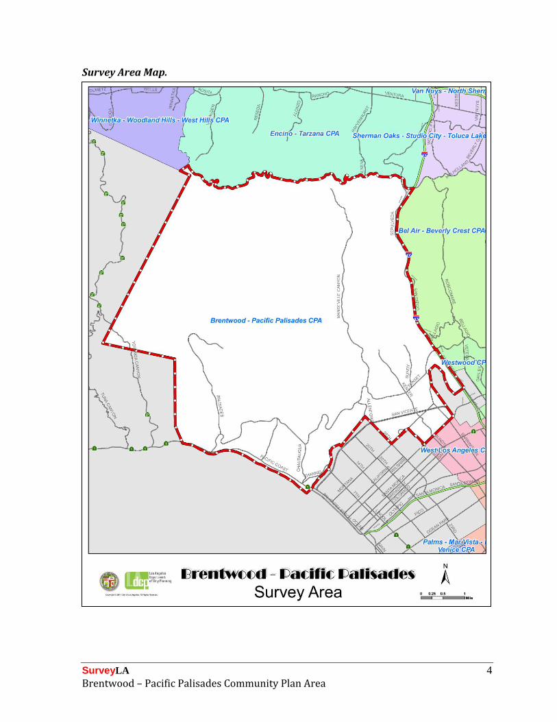
SurveyLA 4 Brentwood – Pacific Palisades Community Plan Area
Survey Area Map.

SurveyLA 5 Brentwood – Pacific Palisades Community Plan Area
The topography of the Survey Area is highly varied, with the hills of the Santa Monica Mountains dominating the landscape north of Sunset Boulevard; over 55 percent of the gross land area of the CPA is public open space, located primarily in this mountainous area. The beach which hugs most of the Pacific coastline has been a constant influence on the development of the Survey Area. The community of Pacific Palisades is characterized by mesas separated by several canyons, including Santa Monica Canyon, Rustic Canyon, Temescal Canyon, and Santa Ynez Canyon. The street patterns in the canyons are primarily meandering in nature, dictated by the topography. Streambeds run along the base of some of the canyons. Development in Pacific Palisades has been affected over the years by natural phenomena, specifically the erosion of the palisades overlooking the coast highway and the Pacific Ocean, and the flooding of the creek that was subsequently channelized in Santa Monica Canyon. In the Brentwood community, the area south of Sunset Boulevard generally slopes gently upwards to the north, with grid-patterned subdivisions dominating south of San Vicente Boulevard and immediately west of the 405 Freeway in the Brentwood Glen neighborhood. Gently curving streets with generously sized lots are found in the area between San Vicente and Sunset Boulevards west of Barrington Avenue. This street plan continues north of Sunset, merging into the hills and canyons, principally Mandeville Canyon and Kenter Canyon. Nearly all of the improved streets contain single-family houses, with multi-family residences confined primarily to the area between San Vicente and Wilshire Boulevards and in the vicinity of the Barrington Avenue corridor. The Survey Area in its entirety is traversed by the circuitous route of Sunset Boulevard on the westernmost leg of its journey from the original pueblo of Los Angeles to the sea. Originally known as Beverly Boulevard, Sunset was extended all the way to the Pacific in 1926, stimulating residential development along its path. Historically the “Main Street” of Brentwood, San Vicente Boulevard provides a second east-west corridor that continues within the City of Santa Monica west of 26th Street all the way to Ocean Avenue. Similarly, Wilshire Boulevard and Montana Avenue function as east-west arterials, crossing into Santa Monica west of Carmelina Avenue. Although Mulholland Drive forms much of the northernmost boundary of the Survey Area, it is largely inaccessible, except from the eastern edge of the CPA at Sepulveda Boulevard. Major north-south thoroughfares include Barrington and Bundy Avenues, as well as the 405 Freeway in Brentwood and Pacific Coast Highway in Pacific Palisades. Both San Vicente Boulevard and Pacific Coast Highway were locations of former railroad and streetcar lines and figured prominently in the famed “Balloon Route” excursions of the interurban Pacific Electric railway. Overwhelmingly residential in development, the Survey Area also contains a handful of historic commercial clusters that service the surrounding neighborhoods. These are located along the eastern stretch of San Vicente Boulevard, at 26th Street and San

SurveyLA 6 Brentwood – Pacific Palisades Community Plan Area
Vicente Boulevard (Brentwood Country Mart), and at the intersection of Barrington Avenue and Sunset Boulevard (Brentwood Village) in the Brentwood area. In addition, the Wilshire corridor is entirely commercial in use, although most of the extant development dates from the later part of the 20th century. In Pacific Palisades, historic commercial development is limited to small segments of West Channel Road and Sunset Boulevard where they meet Pacific Coast Highway and the historic center of the community in the vicinity of the intersection of Sunset Boulevard and Via de la Paz. There are no extant industrial uses in the Survey Area. Two country clubs, Riviera at the inland edge of Pacific Palisades, and Brentwood near the western end of Brentwood, provide verdantly landscaped islands in the midst of residential neighborhoods, and are complemented by the Bel-Air Bay Club, established as a coastal counterpart of the Bel-Air Country Club in the late 1920s. Will Rogers State Historic Park occupies a substantial portion of the former Pacific Palisades estate of the renowned entertainer, complete with ranch house and polo field. Three more recent sites in the Survey Area are the Getty Villa, opened in 1974 on the Claude Parker/Getty Estate adjacent to Malibu; the Getty Center campus of the J. Paul Getty Museum, opened in 1997 on a plateau overlooking the Sepulveda Pass in Brentwood; and the Skirball Cultural Center, located at the northeast corner of the Survey Area since 1996. The topography and the development history of the Survey Area have resulted in strongly identifiable neighborhoods. In Pacific Palisades, these include Santa Monica Canyon, Rustic Canyon, the Founders Tracts (No. 1 and No. 2), The Riviera, Castellammare, Miramar, and Huntington Palisades. Sullivan Canyon straddles the border between the two communities. Brentwood neighborhoods include Westgate, Brentwood Park, Brentwood Glen, Mandeville Canyon, Kenter Canyon, and Crestwood Hills. The terrain has also led to some natural disasters, including fires and landslides, that have periodically impacted the Survey Area, most devastatingly the Bel-Air Fire of 1961, which claimed hundreds of homes. The Survey Area occupies all of Rancho Boca de Santa Monica and parts of Rancho San Vicente y Santa Monica, and descendants of the rancho grantees still reside in the Santa Monica canyon section of Pacific Palisades. The majority of the Survey Area was annexed to the City of Los Angeles on June 14, 1916 as part of the Westgate annexation. The remainder, Santa Monica Canyon, was annexed almost a decade later, on April 28, 1925. The rich historical legacy of the Survey Area spans both pre- and post-annexation periods, with the most intense development occurring during the 1920s and the post-World War II boom of the 1950s. Both Brentwood and Pacific Palisades evolved as a mostly affluent area of predominantly single-family homes, a direction which was determined by the subdividers. In part because of the generous budgets that well-heeled property owners made available for home construction, most neighborhoods showcase numerous examples of outstanding residential architecture, ranging in style from the Spanish Colonial Revival favored by architects such as John Byers in the 1920s, to the modern architecture developed by Richard Neutra and the so-called “Second

SurveyLA 7 Brentwood – Pacific Palisades Community Plan Area
Generation” in the mid-twentieth century, and the California ranch houses created by Cliff May in the postwar era. Pacific Palisades was the headquarters of the innovative Case Study House program conceived by Arts and Architecture editor John Entenza in 1945. Attractive and challenging building sites, many on canyon hillsides or offering spectacular ocean, mountain, or city views, and the presence of a growing community of artists, writers, and other creative types, particularly in Pacific Palisades, also drew architects and designers to the area, several of whom decided to make their own homes in the area. Not surprisingly, numerous Hollywood celebrities settled in Pacific Palisades and Brentwood, their homes widely published on postcards and in magazines. A big draw of the Survey Area, both to entertainment industry figures and others, was its rustic character and terrain that offered ample opportunities to pursue equestrian activities. Equestrian facilities in the CPA were utilized by the 1932 Olympics held in Los Angeles. Several large estates with paddocks, stables, and horse trails, such as the 120-acre Robert Taylor estate in upper Mandeville Canyon, are the legacy of this era. Ethnicity in the Survey Area subsequent to the Rancho era has been and continues to be predominantly Anglo. Initially, this was mandated by deed restrictions, which limited lot and home purchasers to Caucasians. A short-lived (1899-1920) Japanese fishing village was located along the coast between the mouths of Potrero and Temescal Canyons; this enterprise also included a small population of Russian fishermen. Beginning with the arrival of Austrians Berthold and Salka Viertel in 1929, and continuing into the 1930s and 1940s, Pacific Palisades became a center for European émigrés, many of them internationally known writers, artists, and musicians escaping Nazi Germany. Several of these new arrivals were Jewish, and over the intervening years the Survey Area as a whole has become home to a substantial Jewish population. More recent arrivals have included many Asians and Iranians. Pacific Palisades Development History Most of Pacific Palisades lies within the boundaries of the Rancho Boca de Santa Monica, which was granted by the Mexican governor of California to Francisco Marquez and Ysidro Reyes in 1839. Marquez, a blacksmith, built an adobe on the slopes of Santa Monica Canyon where San Lorenzo Street lies today. Reyes, whose primary residence was in the Los Angeles pueblo, maintained a ranch on the hills adjacent to Rustic Canyon. The rancho was used primarily for grazing cattle and sheep. The area that would become Pacific Palisades remained mostly agricultural well into the first decades of the 20th century. However, as early as the 1860s, Santa Monica Canyon had become popular with the residents of Los Angeles as a destination to escape the summer heat. Two hotels had been erected by 1874, and seasonal

SurveyLA 8 Brentwood – Pacific Palisades Community Plan Area
businesses, including bathhouses, a restaurant, dance pavilion, restaurant, saloon, grocery and horse facilities, sprang up to serve the tent camps that housed the visitors. It was reported in 1876 that 45 families were living in tents, their numbers swelling by several hundred on the weekends. Abbot Kinney, the eventual founder of Venice, California, purchased the mesa west of Santa Monica Canyon from one of the Marquez heirs in 1887 and announced plans for “Santa Monica Heights” on the property which eventually became known as the Huntington Palisades. However, the collapse of the Los Angeles regional land boom the following year led Kinney to abandon his plans, and to sell the property to railroad baron Collis P. Huntington in 1891. Kinney, along with Senator Jones and Arcadia de Baker, also established the first forestry station in the nation in Rustic Canyon in 1887. The station, whose purpose was to study the usefulness of non-native trees such as eucalyptus, was operated by the University of California from 1893 until its demise in 1923.2 Huntington’s interest in the area originally focused on the establishment of a deep water port to serve the City of Los Angeles. Towards that end, he built the “Long Wharf” at the foot of Potrero Canyon in 1893, a mile-long facility complete with railroad, coal bunkers, warehouse, employee living quarters, and public dining room. Although the endeavor met with some initial success, the question of the location of the Port of Los Angeles was resolved after intense competition among a handful of shoreline communities in 1897 in favor of San Pedro. The last ships arrived at the Long Wharf in 1908. The wharf lived on as a tourist destination, accessed by a trolley from Santa Monica, but was demolished in stages, and disappeared entirely by 1920. Adjacent to the wharf, and extending northwest to the mouth of Temescal Canyon, a Japanese fishing village was established in 1899 by fisherman Hatsuji Sano on land leased from the railroad. Eventually the home of about 300 Japanese families and a small number of Russians, the village also included two hotels. However, this venture was largely abandoned by 1920, by which time most of the fisherman had moved to Terminal Island and the property was condemned. A turning point in the development of Pacific Palisades, as well as the inland area that would become Brentwood, was the formation of the Santa Monica Land and Water Company in 1897. Founded by Senator Jones and Arcadia de Baker with 30,000 acres of land from both the Rancho Boca de Santa Monica and Rancho San Vicente y Santa Monica, this enterprise had been acquired in its entirety by Canadian Robert C. Gillis by 1906. Gillis headed the organization until his death in 1947. Under the aegis of the Santa Monica Land Company, owned by Gillis, railroad entrepreneur Robert P. Sherman, and Charles Le Roy Bundy, subdivision began in earnest in 1912 in Santa Monica Canyon and lower Rustic Canyon. Roads were graded and lots were laid out and
2 Santa Monica Forestry Station Eucalyptus Grove is a designated Historic-Cultural Monument.

SurveyLA 9 Brentwood – Pacific Palisades Community Plan Area
speculative houses, many by Frank L. Bundy, constructed. Several commercial buildings rose at the mouth of Santa Monica Canyon. By 1916, the Canyon was mostly subdivided. An ambitious plan by the firm of Wright, Callender, and Andrews to develop a large swath of what would become Pacific Palisades was advertised in 1913, but World War I intervened, and the scheme went nowhere. An interesting footnote to the developmental history of Pacific Palisades began in 1911, when filmmaking pioneer Thomas Ince arrived in Los Angeles in search of a suitable location to set up shop outside the sphere of the Motion Picture Patents Company. He leased approximately 18,000 acres of ocean front and mountain area in Santa Ynez Canyon (now part of the site of the Self-Realization Fellowship Lake Shrine) and invested thousands of dollars in production facilities and standing sets. At its height, Inceville consisted of five stages, dressing rooms, shops, offices, commissary, power house, reservoir, extensive horse stables and corrals, an arsenal, and a post office, and it employed up to six hundred people. Although Inceville was fully operational in 1916, two events that year portended its demise: Ince opened a second studio in Culver City; and a major fire at Inceville resulted in both injuries and property loss. Several subsequent fires, the loss of one of Ince’s primary movie stars, cowboy actor William S. Hart, and Ince’s death in 1924 under mysterious circumstances put an end to Inceville. The formal founding of the community of Pacific Palisades dates to the year 1921, when the Methodist Camp Meeting and Chautauqua Association, having outgrown its earlier locations in Long Beach and Huntington Beach, held its annual meeting in Rustic Canyon. Looking for a new home and a place to establish a new community dedicated to Christian ideals and peace, the Association, under the leadership of Reverend Charles Holmes Scott, purchased 1,068 acres, not in Rustic Canyon but instead in Temescal Canyon and the mesa to the east, the “Santa Monica Highlands” site previously announced. The Los Angeles Times reported: “The birth of a new seaside city forty-five minutes from Broadway, the creation of what will probably be one of the largest church centers in the world and the investment of at least $4,000,000 in improvements within the next five years are some of the outstanding features of a super-church plan outlined yesterday by Charles H. Scott, superintendent of the Huntington Beach Methodist Assembly.”3 The Pacific Palisades Association was formed and Pasadena landscape architect Clarence Day hired to provide the initial concept for the new city. Bonds were sold, entitling the purchasers to become leaseholders and to have first choice of lots in either Founders Tract No. 1, located north of Beverly (now Sunset) Boulevard and characterized by smaller lots and narrow streets, or Founders Tract No. 2, south of the Boulevard and characterized by larger, more irregular lots and wider streets. Via de la Paz (Street of Peace) was to be the spine of the community, and a commercial section
3 “Modern Seaside City Goal of Methodists.” Los Angeles Times, May 31, 1921.

SurveyLA 10 Brentwood – Pacific Palisades Community Plan Area
was planned for four blocks at the intersection of Via de la Paz and Beverly Boulevard. A large plot was set aside in Temescal Canyon for the Assembly. The lot selection was held on Founders Day, January 14, 1922. The leasehold structure of the contracts allowed the Association to impose restrictions regarding ethnicity and acceptable building types, prohibit sales of tobacco and alcohol, and levy an annual fee for the maintenance of the institutional facilities. Within one week, 257 lots had been sold. Work commenced on street improvements and home construction in the spring. The first Chautauqua and Summer Assembly at the site was held in July 1922. Later in 1922, the well-known landscape architecture firm of Olmsted Brothers, based in Massachusetts, replaced Day and was charged with refinement of the plans, landscaping of the original subdivisions, and expansion of the community by laying out additional tracts, along Chautauqua Boulevard (Chautauqua Heights) and in the newly acquired Jones-Rindge rancho to the west. The 1923 Olmsted subdivisions, including Chautauqua Heights, Temescal Subdivision, Temescal Heights, Western Tract, Western Subdivision, and Las Pulgas, reflected the firm’s characteristic sensitivity to terrain, adapting street patterns to the contours of the land rather than imposing an arbitrary grid, maximizing views, and incorporating landscaping. By the end of 1923, property sales had exceeded a million dollars. Nonetheless, the Olmsted contract was not renewed, although a three-month extension allowed for the completion of work already in progress. In 1924 another milestone was reached, when the Churrigueresque-styled Business Block, located on a wedge-shaped parcel at the intersection of Beverly and East (now Sunset and Swarthmore), was completed.4 In 1926, Dr. Scott and the Pacific Palisades Association, in partnership with Robert C. Gillis, acquired from the heirs of Collis Huntington the 226-acre tract that Abbot Kinney had initially planned to develop on the mesa west of Santa Monica Canyon. Civil engineer W.W. Williams laid out the high-end subdivision in association with Mark Daniels. Their May 1926 design for the Huntington Palisades incorporated wide, gently curving “drives” with many lots oriented to spectacular views and a series of concentric, semicircular streets fanning out from the oval-shaped El Cerco Place. Utilities were placed underground and ornamental light fixtures installed. Many of the eucalyptus trees originally planted by Kinney were retained. Competitors for the Rustic Canyon location that had originally caught the attention of the Methodists were the Uplifters, an offshoot of the downtown Los Angeles Athletic Club, who were searching for a summer home. Modeling themselves after San Francisco’s Bohemian Club, these bon vivants purchased the Edmond ranch which had been constructed adjacent to the Rustic Canyon forestry station in 1895, as well as several other pieces of property. Club members, who included many of the Los Angeles business and professional elite, put Harry Haldeman and Howard Latimer in charge of
4 The Pacific Palisades Business Block is a designated Historic-Cultural Monument.

SurveyLA 11 Brentwood – Pacific Palisades Community Plan Area
building and infrastructure improvements, including paths, roads, landscaping, terraces, and retaining walls. With the Edmond home as an improvised clubhouse, members constructed rustic-styled houses and log cabins on leased land along what became known as Latimer and Haldeman Roads, many apparently using the Pasadena-based architectural firm of Arthur and Alfred Heineman, well-known for their Craftsman style architecture, to provide the designs. After the former Edmond House burned down in 1922, a new, Spanish-styled clubhouse designed by William J. Dodd was constructed.5 Additional property was purchased in 1924 and equestrian facilities, including a polo field, were installed over the next few years, apparently causing financial hardship that was exacerbated by the Great Depression. The houses passed into private ownership and the club sold the remainder of its holdings immediately following World War II. After purchasing 22,000 acres of property from the Santa Monica Mountain Park Company and the Santa Monica Land and Water Company in 1923, oil millionaire Alphonzo E. Bell, Sr. was associated with several affluent developments in the western sections of Los Angeles, including some in Pacific Palisades. The first was the Riviera, developed in association with the Los Angeles Athletic Club, which constructed the Riviera Country Club in upper Santa Monica Canyon in 1927. The adjacent property was subdivided for luxury estates by a syndicate organized for the purpose. Like Bel-Air, Bell’s project to the east, the Riviera was intended to reflect European style and gentility. Two additional tracts, the California Riviera and the Vaughn Riviera, were subsequently marketed by Bell associate and prominent real estate promoter, Frank Meline. The Riviera Country Club included a golf course designed by George C. Thomas, who had recently completed work at the Bel-Air Country Club, as well as extensive equestrian facilities and a lavish, Spanish-styled clubhouse. In 1926, Frank Meline developed Castellammare on Bell’s property located on the bluffs west of Santa Ynez Canyon. Castellammare, another predominantly luxury development, was envisioned as a Mediterranean community, and Meline stipulated that home builders use Italian Renaissance style architecture. The first home in Castellammare, the 35-room Villa Leon (1928) designed for wool business magnate Leon Kauffman by architect Kenneth McDonald, exemplified Bell’s and Meline’s concept. A third Bell venture, developed by Santa Monica Judge Arthur A. Weber and George W. Ley and marketed by the Meline Company, was Miramar Estates. This 1926 subdivision in Santa Ynez Canyon featured landscaping by Mark Daniels and the Casa Miramar restaurant overlooking the Pacific Ocean. It was extensively promoted, most successfully by construction of the Los Angeles Times Demonstration House for Arthur Weber in 1927. Also designed by Daniels, the Spanish-styled house was opened to the
5 The Uplifters Clubhouse (now the Rustic Canyon Recreation Center) is a designated Historic-Cultural
Monument.
SurveyLA 12 Brentwood – Pacific Palisades Community Plan Area
public for the month of May 1928. Now known as the Villa Aurora, the house was purchased by German writer Lion Feuchtwanger and his wife Marta in 1943.6 Daniels and Bell partnered again when the landscape architect provided a planting scheme to complement architect Elmer Grey’s design for the Bel-Air Bay Club (1927-1928). Perched on a site overlooking the sea east of Santa Ynez Canyon, the Bel-Air Bay Club was intended by Bell to be the coastal outpost of the Bel-Air Country Club, with home sites available for purchase surrounding it. Once again, Mediterranean style architecture was required; however, nearly all lots remained unimproved until after World War II. In the late 1930s and early 1940s, this area witnessed a dramatic influx of European intelligentsia, particularly of Jewish exiles who had fled Europe in advance of World War II. Writers and actors Salka and Berthold Viertel Berthold hosted a salon every Sunday at their Pacific Palisades home that was attended members of this creative émigré community, including actors, writers, composers, directors and others. Individuals included German writer and Nobel laureate Thomas Mann; German writer and director Bertolt Brecht; Austrian actor and director Max Reinhardt; and Russian cellist Gregor Piatigorsky. The community also spilled over into the neighboring Brentwood to include German novelist and playwright Lion Feuchtwanger, and Austrian composer and painter Arnold Schoenberg. Other local expatriates included English writers Aldous Huxley and Christopher Isherwood, English actor and filmmaker Charlie Chaplin, and Swedish actress Greta Garbo. Sullivan Canyon, just west of Mandeville and the location of stables that Robert C. Gillis had built for his daughter’s horses, was also improved in the 1930s. Architectural designer Cliff May, credited as the father of the ranch house style, created the Riviera Ranch tract, a horse-friendly neighborhood, in 1939. Custom, May-designed homes shared the landscape with stables, corrals, a riding ring and horse trails. Following World War II, May acquired additional property along the adjacent Old Ranch Road and designed more homes, including his own in 1954, which he called “Mandalay.” The Depression slowed the pace of development Pacific Palisades, which began to recover in the late 1930s and fully rebounded in the post-World War II years. As the community diversified, new institutions arose, one of the earliest being St. Matthews’s Episcopal Church, whose Carleton Winslow-designed sanctuary (no longer extant) was dedicated in 1942. A new boom in subdivision and housing construction began in 1947, picking up steam in the 1950s and continuing in the following decades, until public alarm over potential overbuilding contributed to the creation of the Santa Monica Mountains State Park. Early subdivisions during this period were in Rustic Canyon and on the acreage formerly owned by Will Rogers and not part of the park established on
6 Villa Aurora is a designated Historic-Cultural Monument.

SurveyLA 13 Brentwood – Pacific Palisades Community Plan Area
his estate in 1944. The equestrian property of the Riviera Country Club was subdivided, with the exception of one polo field, which became the home of Paul Revere Junior High School, opened in 1955. One of the largest new subdivisions was Marquez Knolls, a 118-acre residential development. And throughout the community, empty lots in the older subdivisions were improved. Changes in zoning allowed expansion of the business district along Via de la Paz, Swarthmore, and Sunset in the years immediately prior and decade subsequent to the war. Marking the postwar growth in the community, Palisades High School opened on a cleared and filled site in Temescal Canyon in 1961. Brentwood Development History The impetus for the initial development of Brentwood was the establishment of the Pacific Branch of the National Home for Disabled Volunteers. Opening its doors in 1888 on land donated by Arcadia de Baker, Senator John P. Jones, and the owners of the Wolfskill tract, the “Old Soldiers’ Home” was located immediately east of the area that would become Brentwood. The town of Sawtelle grew up on the lands south of the institution. Brentwood lies within the boundaries of the Rancho San Vicente y Santa Monica, granted in 1828 to Francisco Sepulveda. In 1905, Robert Gillis, who by that time controlled the Rancho lands through his association with the Santa Monica Land and Water Company, began to subdivide “Westgate,” so named because it was located adjacent to the west gate of the Soldiers’ Home. This subdivision was quickly followed by Westgate Acres, Westgate Gardens, and Westgate Heights. Los Angeles and Pacific Railroad Company tracks were installed along San Vicente Boulevard, which had been graded in 1905, to connect the new subdivisions by streetcar with the rest of Los Angeles. Advertisements for the Westgate subdivisions touted their proximity to the Soldiers’ Home and boasted that the trip downtown only required 35 minutes. The tracks remained in place until circa 1942, when the Pacific Electric Railroad, which had absorbed the Los Angeles and Pacific in 1911, discontinued streetcar service and five miles of coral trees were planted in place of the tracks down the center of San Vicente Boulevard. The name “Brentwood” first appears in 1906, when the Western Pacific Development Company bought 350 acres from the Santa Monica Land and Water Company and announced development of an exclusive tract to be known as Brentwood Park. Said to be located “midway between the National Soldiers’ Home and the Pacific,” the tract extended north from San Vicente Boulevard beyond Sunset (then Beverly) Boulevard, with Bristol Avenue, originally called Grand Avenue, as its central thoroughfare. The distinctive layout of the new subdivision incorporated over three dozen landscaped

SurveyLA 14 Brentwood – Pacific Palisades Community Plan Area
traffic circles, one at each intersection, and approximately the same number of ovals situated midblock. Streets curved gracefully to follow the contours of the land and at 75- to 180-feet wide were generously scaled. Lots were varied in size and shape and most had a minimum of a 100-footstreet frontage. Publicity for the development claimed that John McLaren, famed landscaper of San Francisco’s Golden Gate Park, had supervised the planting, which was said to incorporate some 80,000 trees, including many native sycamores and oaks.7 Restrictions stipulating minimum setbacks; prohibiting billboards and oil wells, business uses, more than one house per lot, and distillation or sale of alcohol; and dictating race, color, and creed of buyers and residents were imposed.8 Despite the reputed $1,000,000 investment by its backers, Brentwood Park got off to a slow start, forcing Western Pacific to sell a substantial interest to Dr. Herman Janss of the Braly-Janss Company. By 1916 only about twenty-five percent of the lots had been sold, but sales and construction picked up markedly in the 1920s, when several of the most prominent architects in the region were called upon to design lavish homes in the then fashionable Period Revival architecture styles. Subdivision activity also accelerated during the 1920s. San Vicente Park (running along Bundy between Wilshire, then called Nevada, Boulevard and Montana Avenue), Brentwood Canyon Estates (along Carmelina Avenue), Brentwood Green (north and south of Sunset along Gretna Green and Kenter) were some of the tracts recorded during the decade. In Mandeville Canyon, Alphonzo Bell, Robert C. Gillis, and Henry O’Melveny, among notables, organized the Garden Foundation, acquired some 3,500 acres stretching from Sunset Boulevard to Mulholland Highway, and established the California Botanic Garden. Residential lots on the upper slopes of the canyon were sold to endow the garden, for which 800 acres was reserved on canyon floor and lower slopes. The former dean of the University of California College of Agriculture, E. D. Merrill, was appointed director. Plans included artificial ponds and streams, woodlands, specialty gardens, and a “Forest of Fame,” wherein celebrities planted trees, the event memorialized on plaques. Plant species from around the globe were imported. The partially completed garden opened in 1928, but soon ran into financial difficulties and closed permanently in 1935. A new subdivision, the Botanic Garden Park, opened in its place. Remnants of the gardens, including two ponds, non-native plant species, and some trees from the Forest of Fame, still survive on private property. The picturesque stone bridge on Westgate Road is a unique visual reminder of the area’s past. Development in the canyon was further impacted by a flood in 1938, but resumed in the early 1940s, much of it oriented around horse properties. While building activity may have slowed in the early 1930s, it recovered as the decade progressed. Brentwood Glen, although subdivided in the 1920s as the Ratteree Tract, saw its definitive development between 1935 and 1942. More dense in layout than 7 “Art in Nature Luxuriating: Beauties of Landscape Are Well Utilized.” Los Angeles Times, August 16,
1907. 8 Brentwood Park website, www.brentwoodpark.org.

SurveyLA 15 Brentwood – Pacific Palisades Community Plan Area
many other Brentwood neighborhoods, this Westwood-adjacent enclave saw its growth stimulated by the opening of the University of California campus in 1929, attracting many members of the UCLA faculty. It was somewhat isolated by the construction of the 405 Freeway between 1954 and 1960. Brentwood was affected like all communities by the World War II suspension of building activity. In 1946, rising housing costs and the post-war housing shortage led four musicians to form a cooperative association for the purpose of combining their housing budgets, reasoning that they would therefore be able to afford communally what was beyond their means individually. Interest in the concept mushroomed, and membership in the Mutual Housing Association eventually reached five hundred. Eight hundred acres off of Kenter Avenue were purchased and leading architects were interviewed. A contract was signed with Whitney R. Smith and A. Quincy Jones as architects and Edguardo Contini as engineer. In 1948, the team presented the Association with a booklet, Mutual Plans, containing 28 house designs, from which the Association chose eight to be constructed. One hundred and sixty homes were eventually built, utilizing materials such as concrete block and wood, expansive glass walls, and low-pitched roofs. Communal facilities included a nursery school, credit union, and park; plans for other amenities and services were not realized. Crestwood Hills, as the development became known, was the only successful housing cooperative in the state of California.9 Unfortunately, approximately five dozen of these midcentury modern homes were destroyed in the 1961 Bel Air fire.10 As construction of single-family homes accelerated to meet demand in the post-World War II years, builders ventured further up the canyons north of Sunset Boulevard. These years also witnessed a large leap in the scale of single-family development efforts.11 Additionally, a neighborhood of multi-family apartment buildings was constructed on the old Westgate tract. Brentwood was from the outset a “suburb, away from the noise, dust, and inharmonies of the city.”12 A handful of commercial and institutional developments supported the growth of the community. As the main street of the Brentwood community and site of
9 Buckner, Cory. A. Quincy Jones. New York and London: Phaidon Press, Limited, 2002. Pages 88-99. 10 Seventeen of the original MHA residences are designated Historic-Cultural Monuments. 11 One attempt at this larger-scale development in the postwar years was Southdown Estates. Launched
in 1952 by Pardee-Phillips Construction Co., Southdown Estates was intended as a "luxury-grade" residential subdivision of two- to four-bedroom Traditional ranch-style homes designed by architectural & engineering firm Daniel, Mann, Johnson & Mendenhall (DMJM). Occupying 25 acres of the former Hamilton Garland estate near the intersection of Sunset Boulevard and Bienveneda Avenue, the site was subdivided into 89 residential lots. However, this plan was ultimately unsuccessful, as Modernist architects Jones & Emmons were subsequently brought in to develop innovative designs to infill on the smaller lots. As such, the original vision for Southdown Estates was never fully realized.
12 “Art in Nature Luxuriating: Beauties of Landscape Are Well Utilized.” Los Angeles Times, August 16, 1907.
SurveyLA 16 Brentwood – Pacific Palisades Community Plan Area
the interurban railway tracks that linked the area with the rest of Los Angeles, San Vicente Boulevard immediately west of the Old Soldiers’ home developed as the first commercial and institutional enclave. In 1928, the Sisters of St. Joseph of Carondolet, constructed a Catholic women’s college, Mt. Saint Mary’s, on 33 acres in the Brentwood hills. The Brentwood Country Club, which had a checkered history, changing sites and owners over the years, was established in its current location by the late 1920s. The Brentwood Presbyterian Church was constructed in 1929 and expanded following World War II. One of the most notable landmarks of the Survey Area, the Eastern Star Home, a retirement facility now the home of the Archer School, was erected on Sunset Boulevard in 1931, its Spanish Colonial Revival architecture by the William R. Mooser Company epitomizing the characteristics of the style.13 In 1943, the University Synagogue was organized and in 1955 moved into its permanent home on Sunset Boulevard and Saltair Avenue. Brentwood Country Mart opened in 1948 on land set aside in the 1920s Brentwood Place subdivision for commercial purposes. Brentwood Village developed around the same time, spurred by the post-war residential explosion in the area. Summary As of 2000, the population of Pacific Palisades totaled 23,940 and Brentwood numbered 31,344. The Survey Area is still a “bedroom community” of mostly single-family homes which enjoys one of the lowest population densities within the City of Los Angeles. While the majority of historic resource property types are single-family houses, other property types reflecting the area’s development history are also present, and include commercial, institutional, and religious properties. Overall, property types remain from most of the significant eras of the community’s development, representing a variety of historic contexts and themes.
13 The Eastern Star Home is a designated Historic-Cultural Monument.

SurveyLA 17 Brentwood – Pacific Palisades Community Plan Area
Development by Decade Map.

SurveyLA 18 Brentwood – Pacific Palisades Community Plan Area
Designated Resources The following map depicts designated resources within the Brentwood-Pacific Palisades CPA at the time of the survey. These include properties listed in the National Register of Historic Places (NR) and/or the California Register of Historical Resources (CR), as well as locally designated Los Angeles Historic-Cultural Monuments (HCM). For the most up-to-date information on designated resources contact the Office of Historic Resources.

SurveyLA 19 Brentwood – Pacific Palisades Community Plan Area
Designated Resources Map.
SurveyLA 20 Brentwood – Pacific Palisades Community Plan Area
Community Plan Area Survey Methodology The field survey was conducted using the methodology established by the Office of Historic Resources for SurveyLA, which includes the citywide Historic Context Statement and customized mobile Field Guide Survey System (FiGSS).14 The field work was conducted in two phases: Reconnaissance and Documentation. The Reconnaissance Phase was conducted by a team of two qualified survey professionals, both of whom meet the Secretary of the Interior’s Professional Qualifications Standards. This phase involved a detailed and methodical review of each neighborhood, street, and individual property within the Survey Area. It was during this phase that decisions were made about which properties and districts should be documented, and how those properties should be evaluated. By making these decisions up front and as a team, this methodology ensures a more thoughtful approach to resource identification and evaluation, creates greater consensus among the field survey teams, and produces more consistent survey results. This approach also substantially streamlines the next phase of field survey, enabling the field teams to document large numbers of properties quickly and efficiently. Once the Reconnaissance Phase was completed, the Documentation Phase began. During this phase, field work was conducted by teams of two. Properties that were identified during the previous phase, along with those that had significant associative qualities identified in pre-loaded data in FiGSS, were documented and evaluated for potential historic, cultural, or architectural significance. Documentation included a digital photograph, recordation of historic features and subsequent alterations, and the reason for a property’s potential historic significance. It is also during this phase that contexts and themes are applied and evaluation status codes are assigned. Surveyed properties include residential, commercial, and institutional buildings; infrastructural features such as bridges, tunnels, public stairways, and air raid sirens; and important landscape features, from country clubs to landscaped medians. All field work was conducted from the public right-of-way. Following the completion of field work, all survey data was reviewed in detail by a qualified survey professional to ensure accuracy and consistency throughout. The Brentwood-Pacific Palisades Survey Area presented several challenges for the field survey teams. Many properties could not be completely evaluated due to limited visibility from the public right-of-way. A substantial number of residences are obscured from view, in full or in part, by privacy walls, fences and dense shrubbery. In the canyons and hillsides, residences may be oriented away from the street, or situated at
14 For more information about the SurveyLA methodology, see the SurveyLA Field Results Master
Report.

SurveyLA 21 Brentwood – Pacific Palisades Community Plan Area
the end of long private driveways. Other properties were located on private streets or within gated communities, and therefore were not accessible. To address these issues, an extensive amount of research was conducted prior to fieldwork to assist surveyors in identifying potentially significant properties. Sources including building permits, Sanborn maps, historic photos, and historic and contemporary aerial images.15 Additionally, a substantial number of properties in the Survey Area may be significant for historic associations, most notably as the former residence of a significance person. Again, to address this issue, extensive research was conducted on individual properties to identify specific addresses and the period of residency of the significant person. Sources included City directories, genealogical records, voter registration records, census records, and historical newspapers and periodicals. Research utilized the collections of the Los Angeles Public Library; University of Southern California (USC); University of California, Los Angeles (UCLA); Huntington Library; Historical Los Angeles Times; the Online Archive of California; and the Pacific Coast Architecture Database, among others.
15 All documented properties were evaluated to the extent possible based upon visibility from the public
right-of-way and follow-up research. However, architectural descriptions and integrity assessments could not always be completed. In such instances, all discernible information was recorded and notations were added indicating that the property was not fully visible from the public right-of-way. If possible, the evaluation was completed based upon the available information. However, in some instances the evaluation could not be completed, and a status code of ‘QQQ’ was assigned, indicating that additional research or access to the property would be needed to complete the evaluation, per SurveyLA methodology.
Many residences are difficult to see from the public right-of-way.

SurveyLA 22 Brentwood – Pacific Palisades Community Plan Area
Summary of Findings The following discussion of Property Types, Contexts, and Themes relates to the resources identified and recorded as eligible for designation.
Summary of Property Types The Brentwood-Pacific Palisades CPA contains a diverse range of extant property types, representing a number of periods of development. The following is a brief summary of those property types that were documented and evaluated as historically, culturally, or architecturally significant.
Residential Properties The survey identified a small number of residences dating from the nineteen-teens, representing the earliest development in the survey area. A substantial number of single-family residences from the 1920 through the 1970s were identified for their architectural merit, reflecting a wide range of architectural style, including Craftsman, Period Revival, Ranch, Modern, New Formalist, and Post-Modern. The survey area also contains a number of sprawling residential estates. Significant examples of multi-family residences were not common. Identified historic and planning districts include significant streetcar, automobile, and postwar suburbs. Two equestrian ranch house districts were also identified. Finally, a number of residences were identified for their association with significant persons, including actors, directors, musicians, writers, visual artists, industrialists, and important members of the local European Jewish émigré community.
Commercial Properties The survey identified a small number of intact streetcar-related commercial buildings, as well as a number of streetcar, automobile, and postwar neighborhood commercial centers. Other less common commercial property types include neighborhood markets, banks, and one example of mimetic commercial design. A small number of long-time neighborhood businesses were also identified.
Institutional Properties The survey identified several intact public and private schools dating from the pre-1933 Long Beach Earthquake period through the postwar period, as well as a very rare example of a nineteenth century school house. A handful of religious properties were

SurveyLA 23 Brentwood – Pacific Palisades Community Plan Area
identified, including a significant early church and two religious campuses. Isolated examples of municipal service and public utility buildings were identified, including Department of Water and Power and Metropolitan Water District sites. Additional institutional types include an early 20th-century recreational development, an expansive museum complex, and three country clubs. One site was identified for its association with the LGBT community. Several World War II-era air raid sirens were also identified.
Industrial Properties A decommissioned Nike missile control site is the only industrial property identified in the survey area. Other Properties The survey identified a number of unique or unusual property types. Several examples of public infrastructure were identified, including historic stairways, retaining walls, and bridges. Three tunnels were evaluated, including which provide pedestrian beach access, and one that allows a natural creek to run underneath Sunset Boulevard. The survey also identified a significant landscapes median representing a vacated streetcar line.

SurveyLA 24 Brentwood – Pacific Palisades Community Plan Area
Summary of Contexts and Themes Many of the Contexts and Themes developed for the SurveyLA Citywide Historic Context Statement are represented in the Brentwood-Pacific Palisades Survey Area. The following is a representative sampling of some of the more common Context/Theme combinations used in the survey, as well as some examples that are specific to this part of the city. Each Context/Theme is illustrated with specific examples from the Survey Area. For a complete list of individual resources identified as meeting eligibility standards and criteria for the National Register, California Register, and/or local listing, see Appendix A. For a complete list of non-parcel resources identified as meeting eligibility standards and criteria for the National Register, California Register, and/or local listing, see Appendix B. For a complete list of historic districts identified as meeting eligibility standards and criteria for the National Register, California Register, and/or local listing, see Appendix C. This appendix also includes Planning Districts, which do not meet eligibility standards and criteria for listing but may warrant special consideration for local planning purposes.

SurveyLA 25 Brentwood – Pacific Palisades Community Plan Area
Context: Residential Development & Suburbanization, 1850-1980 Theme: Early Residential Development, 1880-1930 Sub-Theme: Early Single-Family Residential Development, 1880-1930 This Context/Theme was used to evaluate residential properties that substantially pre-date the neighborhood in which they are located. In some cases, these residences may be the first homes built in the area. Examples include a rare example of an Arroyo Stone Craftsman in Pacific Palisades, constructed in 1913 by early settler Frank E. Bundy; and a well-maintained 1911 Craftsman house in Brentwood, the earliest residence identified in the survey area. This Context/Theme was also used to identify the earliest intact houses in significant residential tracts, including Founders Tracts No. 1 and 2, Chautauqua Heights, and Castellammare in Pacific Palisades, and Brentwood Park in Brentwood.
Address: 408 N. Sycamore Road Address: 405 S. Cliffwood Avenue Date: 1913 Date: 1911
Address: 1016 S. Bundy Drive Address: 925 S. Gretna Green Way Date: 1916 Date: 1915

SurveyLA 26 Brentwood – Pacific Palisades Community Plan Area
Context: Residential Development & Suburbanization, 1850-1980 Theme: Streetcar Suburbanization, 1888-1933 Sub-Theme: Suburban Planning & Development, 1888-1933 This Context/Theme was used to evaluate the Brentwood Park Residential Planning District. While not sufficiently intact to qualify as a historic district, this area was identified as a significant early-20th century subdivision in Brentwood developed along the Westgate streetcar line. The area was originally subdivided in 1906, making it one of Brentwood’s earliest subdivisions. It contains approximately 500 parcels on 350 acres, developed with large single-family houses. Original residences date from the 1920s through the 1950s, and exhibit a range of Period Revival architectural styles – including American Colonial, Spanish Colonial, and Tudor – as well as early Modern and Ranch styles. Distinctive planning features include the curvilinear interior street pattern, eight original traffic circles and ovals, large residences on large lots, and an impressive collection of mature trees. Outstanding individual residences were also identified under the Early Residential Context/Theme.
District: Brentwood Park Residential Planning District
District: Brentwood Park Residential Planning District
Description: Street view Description: Street view

SurveyLA 27 Brentwood – Pacific Palisades Community Plan Area
Context: Residential Development & Suburbanization, 1850-1980 Theme: Automobile Suburbanization, 1908-1937 Sub-Theme: Suburban Planning & Development, 1908-1937 This Context/Theme was used to evaluate two residential planning districts in Pacific Palisades: Huntington Palisades and The Riviera. While these areas are not sufficiently intact to qualify as historic districts, both were identified as significant examples of residential suburban planning from the early automobile era. The Huntington Palisades Residential Planning District spans 226 acres on a mesa overlooking the ocean between Potrero and Santa Monica canyons. The area was originally subdivided in 1926 by the Pacific Palisades Association, under the leadership of Rev. Charles Scott, Methodist minister and founder of Pacific Palisades. Original residences date from the 1920s through the 1950s and exhibit a range of Period Revival and Ranch styles. Planning features include its distinctive street pattern, landscaped medians and traffic islands, mature landscaping, and period streetlights. The Riviera Residential Planning District was subdivided in the mid-1920s by real estate developer Alphonzo Bell, who was simultaneously developing the Riviera Country Club just across Sunset Boulevard. The Riviera contains approximately 125 parcels. Original residences were constructed from the 1920s through the 1950s, displaying both Period Revival and Ranch architectural styles. Bell hired landscape architect Mark Daniels to plan the tract and design the landscape. Planning features include period streetlights, stone and granite curbs and gutters, and a landscaped allée flanked by palm trees along D’Este Drive, designed to accommodate both pedestrians and equestrians.
District: Huntington Palisades Residential Planning District
District: Huntington Palisades Residential Planning District
Description: Street view Description: Street view

SurveyLA 28 Brentwood – Pacific Palisades Community Plan Area
District: The Riviera Residential Planning District
District: The Riviera Residential Planning District
Description: Street view Description: Street view

SurveyLA 29 Brentwood – Pacific Palisades Community Plan Area
Context: Residential Development & Suburbanization, 1850-1980 Theme: Automobile Suburbanization, 1908-1937 Sub-Theme: Suburban Planning & Development, 1938-1975 In addition to evaluating examples of residential suburban planning from the early automobile era, this Context/Theme was used to evaluate significant examples of infrastructure and other designed features, such as public stairways and retaining walls, associated with residential development. Some twenty public stairways were identified; all located in the hillside neighborhoods of Pacific Palisades. The Castellammare neighborhood, designed to resemble the Amalfi Coast of Southern Italy, is marked by a series of stone retaining walls and steep concrete stairways. The Entrada/Adelaide Public Stairway is a rare example of a wooden stairway. The lower Mandeville Canyon neighborhood of Brentwood contains a rare example of a 1930s automobile bridge. This bridge is a remnant of the California Botanical Garden, hence its picturesque stone craftsmanship. Following the closure of the garden, the canyon floor was re-subdivided for residential development; the bridge now provides automobile access to the surrounding neighborhood.
Location: Porto Marina Way at Pacific Coast Highway
Location: Porto Marina Way at Pacific Coast Highway
Name: Castellammare stairway and retaining wall
Name: Castellammare stairway and retaining wall
Date: 1925 Date: 1925

SurveyLA 30 Brentwood – Pacific Palisades Community Plan Area
Location: Posetano Road and Revello Drive District: Entrada/Adelaide Public Stairway Name: Revello Drive Public Stairway Address: Entrada Drive to Adelaide Drive Date: 1925 Date: 1934
Location: Westridge Road Name: Westridge Bridge Date: 1928

SurveyLA 31 Brentwood – Pacific Palisades Community Plan Area
Context: Commercial Development, 1850-1980 Theme: Neighborhood Commercial Development, 1875-1960 Sub-Theme: Early Neighborhood Commercial Development, 1880-1930 This Context/Theme was used to evaluate Thelma Todd’s Sidewalk Café as a significant example of early neighborhood commercial development. Built in 1928 by actress Thelma Todd, this commercial block was designed by noted architect Mark Daniels to serve the adjacent Castellammare neighborhood. Todd’s restaurant occupied the ground floor; the upper floor contained her apartment and an exclusive night club. Today, it is a rare and iconic example of 1920s neighborhood commercial development on Pacific Coast Highway in Pacific Palisades.
Address: 17575 Pacific Coast Highway Name: Thelma Todd’s Sidewalk Café Date: 1928

SurveyLA 32 Brentwood – Pacific Palisades Community Plan Area
Context: Commercial Development, 1850-1980 Theme: Streetcar Commercial Development, 1873-1934 This Context/Theme was used to evaluate the San Vicente Boulevard Commercial Historic District as a significant and cohesive collection of 1920s neighborhood commercial development along a streetcar line in Brentwood. The district is composed of one- and two-story storefront buildings, constructed in 1928, and designed in the Spanish Colonial Revival style. It is situated along the former Westgate streetcar line, which ran down the middle of San Vicente Boulevard. Today, this stretch of San Vicente is a disparate collection of commercial uses from various periods. In contrast, this modest collection of low-scale 1920s storefronts is the oldest intact remnant of Brentwood’s original commercial core.
District: San Vicente Boulevard Commercial Historic District
District: San Vicente Boulevard Commercial Historic District
Description: Street view Description: Street view

SurveyLA 33 Brentwood – Pacific Palisades Community Plan Area
Context: Commercial Development, 1850-1980 Theme: Neighborhood Commercial Development, 1875-1960 Sub-Theme: Neighborhood Commercial Centers, 1875-1960 This Context/Theme was used to evaluate three intact collections of neighborhood commercial development: the Brentwood Country Mart, the Brentwood Village Commercial Planning District, and the Swarthmore Avenue Commercial Historic District. Brentwood Country Mart is a 30,000-square-foot open-air shopping and food center. Composed of multiple buildings oriented around two courtyards, the Country Mart contains 22 retail stores and 6 eateries. Originally developed in 1948, developers sought to create a one-stop shopping center in the heart of Brentwood. It is designed in a country vernacular style – with barn-like gambrel roofs, board-and-batten wood siding, and divided-light wood windows and doors – intended to be reminiscent of the Farmers Market in the Fairfax District. The Brentwood Village Commercial Planning District is a small shopping center oriented around two horseshoe-shaped parking lots and a pedestrian street. Extant buildings date primarily from the 1950s, and are occupied by neighborhood-serving commercial uses. The district is anchored by a1939 Spanish Colonial Revival service station, which is a designated Historic-Cultural Monument. The Swarthmore Avenue Commercial Historic District is a highly intact 1950s neighborhood commercial center in Pacific Palisades. This district is composed of attached one-story retail storefronts set at the sidewalk along both sides of the street. Mid-Century Modern in style, buildings feature low, horizontal massing, large display windows, and distinctive rooflines defining each storefront. Constructed as a single development, the district is consistent in massing, scale, and style.
Address: 225 26th Street Location: Sunset Boulevard and S. Name: Brentwood Country Mart Barrington Avenue Date: 1948 Name: Brentwood Village Commercial Planning District Date: 1940s-1960s

SurveyLA 34 Brentwood – Pacific Palisades Community Plan Area
Location: Swarthmore Avenue Location: Swarthmore Avenue Name: Swarthmore Avenue Commercial Name: Swarthmore Avenue Commercial Historic District Historic District Date: 1950-1958 Date: 1950-1958

SurveyLA 35 Brentwood – Pacific Palisades Community Plan Area
Context: Commercial Development, 1850-1980 Theme: Commercial Development and the Automobile, 1910-1980 Sub-Theme: Programmatic/Mimetic, 1918-1950 This Context/Theme was used to evaluate the Shore Bar, one of the few examples of Mimetic architecture remaining in the city of Los Angeles. Constructed in 1923 as Doc Law’s Drugstore, this neighborhood cocktail lounge started out as a speakeasy operating under the guise of being a pharmacy. The building has displayed its distinctive façade, featuring the projecting bow of a ship, since the 1930s. By the 1960s, it had become a popular gay bar called the “S.S. Friendship.” The bar was fictionalized as the "Starboard Side" in Christopher Isherwood's 1964 novel "A Single Man." It would be one of several gay bars in the area adjacent to Will Rogers State Beach, a popular gathering place for members the gay community during this period. This property was also evaluated under the LGBT Context/Theme for this association.
Address: 112 W. Channel Road Address: 112 W. Channel Road Name: Shore Bar Name: Shore Bar Date: 1923 Date: 1923

SurveyLA 36 Brentwood – Pacific Palisades Community Plan Area
Context: Commercial Development, 1850-1980 Theme: Commercial Identity, 1850-1980 This Context/Theme was used to evaluate several properties associated with long-standing local businesses. Vincente Foods market has been in continuous operation at its Brentwood location since 1948; the current building was constructed in 1962. The Golden Bull restaurant in Pacific Palisades has been in business since 1950. The hotel that was originally a Holiday Inn in Brentwood and the supermarket that was originally a Safeway in Pacific Palisades, continue to convey their association with their former tenants through identifiable corporate architecture. The former Holiday Inn (now Angeleno Hotel) is composed of the distinctive round tower that was the chain’s corporate design during the late 1960s and early 1970s. The former Safeway (now Vons) supermarket in Pacific Palisades reflects the prototype developed by noted architects Wurster, Bernardi & Emmons in the 1960s; it is one of the few remaining examples in Los Angeles.
Address: 12027 San Vicente Boulevard Address: 170 N. West Channel Road Name: Vicente Foods Name: The Golden Bull Date: 1962 Date: 1950
Address: 170 N. Church Lane Address: 17380 Sunset Boulevard Name: Holiday Inn (now Angeleno Hotel) Name: Safeway (now Vons) Date: 1970 Date: 1968

SurveyLA 37 Brentwood – Pacific Palisades Community Plan Area
Context: Public & Private Institutional Development, 1850-1980 Sub-Context: Education, 1876-1980 Theme: Public Schools & the LAUSD, 1876-1980 Sub-Theme: Nineteenth Century Schoolhouses, 1876-1894 Sub-Theme: Pre-1933 Long Beach Earthquake, 1912-1933 Sub-Theme: Post-1933 Long Beach Earthquake, 1933-1945 Sub-Theme: Post World War II Schools, 1946-1966 These Context/Themes were used to evaluate significant examples of LAUSD public schools from various periods. Palisades Elementary School and Brentwood Science Magnet School each retain two 1930s school buildings dating to their original establishment. Paul Revere Charter Middle School (originally Palisades-Brentwood Junior High) is a rare intact example of a post-World War II LAUSD campus. Perhaps most notably, however, is the 19th-century schoolhouse building located on the campus of Canyon School in Pacific Palisades. Originally constructed in 1894, this structure may be one of only three schoolhouse buildings remaining in the Los Angeles Unified School District. The building has been restored and now serves as the school’s library.
Address: 421 N. Entrada Drive Address: 800 Via de la Paz Name: Canyon School Schoolhouse Name: Palisades Elementary School Date: 1894 Date: 1930

SurveyLA 38 Brentwood – Pacific Palisades Community Plan Area
Address: 740 Gretna Green Way Address: 1450 Allenford Avenue Name: Brentwood Science Magnet School Name: Paul Revere Charter Middle School Date: 1935 Date: 1955
SurveyLA 39 Brentwood – Pacific Palisades Community Plan Area
Context: Public & Private Institutional Development, 1850-1980 Sub-Context: Private Recreation, 1880-1980 Theme: Private Recreation Facilities, 1880-1980 Sub-Theme: Country Clubs, 1880-1980 This Context/Theme was used to evaluate three early-20th century country clubs: The Bel-Air Bay Club, the Brentwood Country Club, and the Riviera Country Club. The Bel-Air Bay Club occupies a 14-acre hillside site above Pacific Coast Highway overlooking the ocean. The club was originally established by developer Alphonso Bell in the 1920s. The Upper Clubhouse building is an impressive 1930 Spanish Colonial Revival design by noted architects Elmer Grey and Mark Daniels. The Brentwood Country Club was originally established in 1915 as the Sunset Fields Golf Club. Spanning 129 acres, it contains an 18-hole golf course, driving range, tennis courts, swimming pool, and the original clubhouse by noted Westside architect John Byers. Extensive mature landscaping includes a Eucalyptus windbreak along the perimeter. In 1947, the property was purchased by cousins Arthur Edmunds and Edward Zuckerman, who made it one of the few clubs at the time that permitted Jewish members. The Riviera Country Club was conceived in the 1920s by the Los Angeles Athletic Club and local developer Alphonso Bell. Facilities include a driving range, 26 tennis courts, fine dining venues, ballrooms, hotel rooms, and the original 1928 clubhouse designed by J. Bernard Richards. The 18-hole golf course was designed in 1927 by noted golf course architect George C. Thomas, Jr., and incorporates the natural features of the site, including native trees, streams, and the barranca (ravine), which forms a natural hazard. The Brentwood and Riviera Country Clubs are not accessible and integrity assessments could not be made from the public right-of-way. However, research suggests these properties are historically significant; therefore, they have been identified but the evaluations could not be completed. The Brentwood and Riviera Country Clubs were also evaluated under the cultural landscape Context/Theme.

SurveyLA 40 Brentwood – Pacific Palisades Community Plan Area
Address: 590 S. Burlingame Avenue Address: 1250 Capri Drive Name: Brentwood Country Club Name: Riviera Country Club Date: 1915 Date: 1927
Address: 1601 Pacific Coast Highway Name: Bel-Air Bay Club Date: 1930

SurveyLA 41 Brentwood – Pacific Palisades Community Plan Area
Context: Public & Private Institutional Development, 1850-1980 Sub-Context: Religion & Spirituality, 1850-1980 Theme: Religious Property Types, 1850-1980 Significant examples of religious properties were evaluated under this Context/Theme. In this survey area, examples include significant churches as well as religious campuses. The Pacific Palisades Community United Methodist Episcopal Church, known as “the church that founded Pacific Palisades," was established by representatives of the Southern California Conference of the Methodist Episcopal Church, led by Rev. Charles Scott.16 Today’s Temescal Gateway Park is the site of the original Chautauqua Conference Grounds, established in 1922 by Rev. Charles Scott as a West Coast center for the Chautauqua Movement. The site retains many historic features, including the Temescal Camp Store, Woodland Hall, Stewart Hall, original wood cabins, later stucco cabins, a number of residential buildings, as well as stone steps and retaining walls, hiking trails, and mature natural landscaping. The Self Realization Fellowship at Lake Shrine is a 10-acre site on a hilltop overlooking the Pacific Ocean in Pacific Palisades. Originally the site of the Inceville Film Studio, the property had several owners before being acquired by the Self-Realization Fellowship in 1950. Today the property contains features from various periods, including Santa Inez Lake – formed by a gravel quarry that activated an underground spring – the Golden Lotus Archway, various monuments and memorials, a windmill, Japanese junk, a houseboat, and extensive gardens.
Address: 801 N. Via de la Paz Address: 17190 Sunset Boulevard Name: Pacific Palisades Community United Name: Self-Realization Fellowship, Lake Methodist Episcopal Church Shrine Date: 1929 Date: 1950
16
The original church appears to be intact behind a Modern addition.

SurveyLA 42 Brentwood – Pacific Palisades Community Plan Area
Address: 15601 Sunset Boulevard Name: Chautauqua Conference Grounds Date: 1923

SurveyLA 43 Brentwood – Pacific Palisades Community Plan Area
Context: Public & Private Institutional Development, 1850-1980 Sub-Context: Government Infrastructure and Services, 1850-1980 Theme: Municipal Water and Power, 1916-1980 Sub-Theme: Distributing and Receiving Stations, 1916-1980 This Context/Theme was used to evaluate a significant example of a 1930s Department of Water and Power building, designed by noted architect Frederick Roehrig. This property was also evaluated under the Architecture context.
Address: 15349 W Sunset Boulevard Name: Department of Water and Power Distributing Station No. 29 Date: 1935

SurveyLA 44 Brentwood – Pacific Palisades Community Plan Area
Context: Public & Private Institutional Development, 1850-1980 Sub-Context: Cultural Development & Institutions, 1850-1980 Theme: Literature, 1850-1980 Sub-Theme: Writers & Residency in L.A., 1850-1980 Residences associated with important literary figures were evaluated under this Context/Theme. In this survey area, examples include the long-time residences of authors Christopher Isherwood, Henry Miller, and Thomas Mann, all located in Pacific Palisades.
Address: 444 N. Ocampo Drive Address: 145 N. Adelaide Drive Name: Henry Miller Residence Name: Christopher Isherwood Residence Date: 1963-1980 Date: 1959-1986

SurveyLA 45 Brentwood – Pacific Palisades Community Plan Area
Context: Public & Private Institutional Development, 1850-1980 Sub-Context: Cultural Development and Institutions, 1850-1980 Theme: Visual Arts, 1888-1980 Sub-Theme: Visual Artists in L.A., 1888-1980 Residences associated with important figures in the visual arts were evaluated under this Context/Theme. In this survey area, examples include the residences of photographer Edward Weston and muralist Hugo Ballin.
Address: 446 N. Mesa Road Address: 567 N Almoloya Drive Name: Edward Weston Residence Name: Hugo Ballin Residence Date: 1934-1937 Date: 1928-unknown

SurveyLA 46 Brentwood – Pacific Palisades Community Plan Area
Context: Public & Private Institutional Development, 1850-1980 Sub-Context: Government Infrastructure and Services, 1850-1980 Theme: Transportation Infrastructure, 1880-1980 Sub-Theme: Pedestrian Tunnels, 1918-1960 Pedestrian tunnels were evaluated under this Context/Theme for their association with the city’s transportation infrastructure. Two examples were identified in Pacific Palisades where they run underneath Pacific Coast Highway, providing pedestrian access from residential and commercial neighborhoods to the beach.
Location: Pacific Coast Highway and West Location: Pacific Coast Highway to Will Channel Road Rogers State Beach Date: circa 1940 Date: circa 1940

SurveyLA 47 Brentwood – Pacific Palisades Community Plan Area
Context: Public & Private Institutional Development, 1850-1980 Sub-Context: Military Institutions & Activities, 1850-1980 Theme: Air Raid Sirens & Civil Defense, 1939-1960 Air raid sirens were evaluated under this Context/Theme for their association with World War II and Cold War military infrastructure in Los Angeles. Just two examples are located in the Survey Area; it appears that several others have been removed.
Location: Sunset Boulevard and Barrington Avenue
Location: Sunset Boulevard at Mandeville Canyon Road
Name: Air Raid Siren No. 142 Name: Air Raid Siren No. 141 Date: circa 1940 Date: circa 1940

SurveyLA 48 Brentwood – Pacific Palisades Community Plan Area
Context: Cultural Landscapes, 1875-1980 Sub-Context: Designed Landscapes, 1875-1980 Theme: Monumental Civic Improvements, 1916-1940 The landscaped median along San Vicente Boulevard, between Federal Avenue and 26th Street, was evaluated under this Context/Theme. This median is significant for its association with the vacated Westgate streetcar line. The Westgate line of the Pacific Electric streetcars operated from 1906 until 1942, when the trolley tracts were removed and the median was planted with grass for horseback riding. The existing coral trees were planted in the late 1940s through a grant from the Los Angeles Beautiful program. The median and coral trees continue westward all the way to Ocean Avenue in Santa Monica.17
Location: San Vicente Boulevard Location: San Vicente Boulevard Name: San Vicente Boulevard Median Name: San Vicente Boulevard Median Date: circa 1945 Date: circa 1945
17 The coral trees are a designated Historic-Cultural Monument.

SurveyLA 49 Brentwood – Pacific Palisades Community Plan Area
Context: Architecture & Engineering, 1850-1980 Theme: American Colonial Revival, 1895-1960 Sub-Theme: American Colonial Revival, Early, 1895-1940 Sub-Theme: American Colonial Revival, Late, 1940-1960 Significant examples of American Colonial Revival architecture were evaluated under this Context/Theme. Examples were primarily single-family residences, some of which also represent the work of noted architects, including Paul Williams, Gerard Colcord, Allen Siple, Byers & Muir, and Marston & Maybury.
Address: 150 S. Barrington Place Address: 467 N. Halvern Drive Date: 1949 Date: 1940 Architect: Marston & Maybury
Address: 2220 N. Mandeville Canyon Road Address: 363 N. Carmelina Avenue Date: 1938 Date: 1925 Architect: Gerard Colcord Architect: Byers & Muir

SurveyLA 50 Brentwood – Pacific Palisades Community Plan Area
Context: Architecture & Engineering, 1850-1980 Theme: Mediterranean & Indigenous Revival Architecture, 1887-1952 Sub-Theme: Spanish Colonial Revival, 1915-1942 This Context/Theme was used to evaluate significant examples of Spanish Colonial Revival architecture. Examples in Brentwood and Pacific Palisades generally are elaborate single family residences, some of which are the work of noted architects, including Mark Daniels, Paul R. Williams, Byers & Muir, and Parkinson & Parkinson. A handful of institutional examples of the style were identified as well, including Palisades Elementary School, Brentwood Science Magnet School, and the Bel-Air Bay Club, designed by noted architects Mark Daniels and Elmer Grey.
Address: 472 N. Barrington Avenue Address: 250 S. Bristol Avenue Date: 1928 Date: 1926
Address: 314 S. Rockingham Avenue Address: 1100 N. Corsica Drive Date: 1927 Date: 1930

SurveyLA 51 Brentwood – Pacific Palisades Community Plan Area
Context: Architecture & Engineering, 1850-1980 Theme: Arts & Crafts Movement, 1895-1930 Sub-Theme: Tudor Revival, 1895-1929 Theme: Period Revival, 1919-1950 Sub-Theme: Tudor Revival, 1930-1950 This Context/Theme was used to evaluate significant examples of Tudor Revival architecture. A handful of examples were identified, all single-family residences, including a small cluster located on Lucca Drive in The Riviera neighborhood of Pacific Palisades. Some of these are also the work of noted architects, including Gerard Colcord and Byers & Muir.
Address: 223 N. Bristol Avenue Address: 13545 W. Lucca Drive Date: 1932 Date: 1929 Architect: Gerard Colcord
Address: 13541 W. Lucca Drive Address: 509 N. Rockingham Avenue Date: 1930 Date: 1927 Architect: Gerard Colcord

SurveyLA 52 Brentwood – Pacific Palisades Community Plan Area
Context: Architecture & Engineering, 1850-1980 Theme: Period Revival, 1919-1940 Sub-Theme: French Norman, 1919-1940 Significant examples of French Norman architecture were evaluated under this Context/Theme. A small number were identified in the survey area, all of which are single-family residences. Several of these also represent the work of noted architects, including Paul Williams, Robert D. Farquhar, and Byers & Muir.
Address: 624 N. Ocampo Drive Address: 915 N. Amalfi Drive Date: 1928 Date: 1937 Architect: Paul Williams

SurveyLA 53 Brentwood – Pacific Palisades Community Plan Area
Context: Architecture & Engineering, 1850-1980 Theme: The Ranch House, 1930-1975 Sub-Theme: Traditional Custom Ranch House, 1930-1975 A small number of significant examples of Ranch architecture were evaluated under this Context/Theme. All identified examples were single-family houses representing the work of noted architects, including Paul Williams, John Byers, and Cliff May.18 These include Cliff May House No. 2, the first house May built for his family in Los Angeles, and Cliff May House No. 3, which also served as the model home for the Riviera Ranch Development (see below).
Address: 1831 N. Old Orchard Road Address: 1867 N. Mandeville Canyon Road Name: William H. Theobald Residence Name: Cliff May House No. 2 Date: 1948 Date: 1937 Architect: Cliff May Architect: Cliff May
18 Early intact examples of Cliff May-designed Ranch houses, dating from the 1930s-1940s, were
identified as individually significant, as representative of May’s development of the ranch house as a residential building type that would proliferate throughout the region in the following decades. Later examples, from the 1950s-1970s were not identified individually.

SurveyLA 54 Brentwood – Pacific Palisades Community Plan Area
Context: Architecture & Engineering, 1850-1980 Theme: Housing the Masses, 1880-1975 Sub-Theme: Ranch House Neighborhoods, 1938-1975 This Context/Theme was used to identify two significant collections of California Ranch-style residential architecture in the Sullivan Canyon area of Pacific Palisades, both designed by noted architect Cliff May. The Riviera Ranch Residential Historic District was designed as a neighborhood of small equestrian ranches. The district is developed with single-family residences, many featuring split-rail fences, horse stables, and corrals at the street. Original residences were constructed primarily from the 1940s through the early 1950s, and deed restrictions ensured that they were designed in the rustic California Ranch style, many of them by Cliff May himself. Features include low horizontal massing, rambling plans, wood or stucco cladding, and clay tile or wood shake roofs. District features include an insular street pattern of meandering cul-de-sacs, landscaped islands, bridle paths, the absence of sidewalks and streetlights, lush landscaping, and many mature trees. This district also contains May’s private residence, Cliff May House No. 3. Located near the entrance to the subdivision, the house was the first constructed in the tract and served as a demonstration model for the development. In 1940, the house was opened to the public, and was widely publicized by May. Cliff May House No. 3 has been called one of the most significant ranch houses in the nation, and Riviera Ranch is Cliff May’s most significant and fully-realized residential suburban design. The Old Ranch Road Residential Historic District is located immediately adjacent to Riviera Ranch, and shares many of the same features. Like Riviera Ranch, it was designed for equestrian use and many properties feature split-rail wood fences, horse stables, and corrals. Original residences were constructed primarily in the 1950s and designed in the California Ranch style, many by Cliff May. Bridle paths line portions of the lush winding road, which terminates at the site of Cliff may House No. 5 (a.k.a. “Mandalay”). This sprawling estate was May’s last personal residence; he died here in 1989 at the age of 80. The residence was demolished in 1994; however, the gate house is extant at the end of Old Ranch Road.

SurveyLA 55 Brentwood – Pacific Palisades Community Plan Area
District: Riviera Ranch Residential Historic District: Riviera Ranch Residential Historic District District Description: Street view Description: Street view
District: Riviera Ranch Residential Historic District: Riviera Ranch Residential Historic District District Name: Cliff May House No. 3 Address: 1614 N. Old Oak Road Address: 1500 N. Old Oak Road Date: 1941 Date: 1938
District: Old Ranch Road Residential District: Old Ranch Road Residential Historic District Historic District Description: Street view Description: Street view

SurveyLA 56 Brentwood – Pacific Palisades Community Plan Area
District: Old Ranch Road Residential District: Old Ranch Road Residential Historic District Historic District Address: 1768 N. Old Ranch Road Address: 2200 N. Old Ranch Road Date: 1956 Name: Mandalay Gate House Date: 1956

SurveyLA 57 Brentwood – Pacific Palisades Community Plan Area
Context: Architecture & Engineering, 1850-1980 Sub-Context: L.A. Modernism, 1919-1980 Theme: Pre-War Modernism, 1919-1945 Sub-Theme: Early Modernism, 1919-1945 This Context/Theme was used to evaluate significant examples of Early Modern architecture. Examples include both single-family and multi-family residences. Many represent the work of noted architects, including Lloyd Wright, Thornton Abell, Harwell Hamilton Harris, J.R. Davidson, and Richard Neutra. This includes Neutra's Plywood Model Experimental House, the architect’s experiment with plywood construction. The house was designed so that it could be easily transported; it has been moved twice.
Address: 427 S. Beloit Avenue Address: 12209 W. Dunoon Lane Name: Plywood Model Experimental House Name: Drucker Apartments Date: 1935 Date: 1940 Architect: Richard Neutra Architect: J.R. Davidson

SurveyLA 58 Brentwood – Pacific Palisades Community Plan Area
Context: Architecture & Engineering, 1850-1980 Sub-Context: L.A. Modernism, 1919-1980 Theme: Post-War Modernism, 1946-1976 Sub-Theme: Mid-Century Modernism, 1945-1970 A substantial number of significant examples of Mid-Century Modern architecture were identified in this survey area and evaluated using this Context/Theme. Primarily single-family residences, examples are often located in hillside neighborhoods where they take advantage of sweeping canyon and city views. Many represented the work of noted architects, including Richard Neutra, Lloyd Wright, Buff & Hensman, Ain Johnson & Day, Raymond Kappe, Rex Lotery, Craig Ellwood, Rodney Walker, Palmer & Krisel, A. Quincy Jones, Harry Gesner, Thornton Abell, Wurster Bernardi & Emmons, Paul Laszlo, Douglas Honnold, Pierre Koenig, Richard Dorman, and Paul Sterling Hoag. An apartment house was identified for the mosaic mural on its façade by noted artist Evelyn Ackerman.
Address: 680 N. Brooktree Road Address: 1095 N. Kenter Avenue Date: 1966 Date: 1958 Architect: Raymond Kappe Architect: Craig Ellwood
Address: 834 N. Leonard Road Address: 1249 N. Tigertail Road Date: 1959 Date: 1966 Architect: Raul Garduno

SurveyLA 59 Brentwood – Pacific Palisades Community Plan Area
Address: 1892 N. Kimberly Lane Address: 1036 N. Tigertail Road Date: 1960 Date: 1952 Architect: Hilyard M. Brown Architect: Craig Ellwood
Address: 11957 W. Kiowa Avenue Address: 15777 Bowdoin Street Date: 1956 Name: Palisades High School Muralist: Evelyn Ackerman Date: 1961
In addition to individual residences identified as excellent example of the Mid-Century Modern style, this Context/Theme was also used to identify sixteen residences designed for the Mutual Housing Association (MHA), designed by A. Quincy Jones and Whitney R. Smith. The MHA was a housing cooperative formed in 1946 in the upper Kenter Canyon area of Brentwood, known as Crestwood Hills. The design team of Jones, Smith and structural engineer Edgardo Contini developed a plan for a community of 500 houses, with limited grading to preserve views and maximize privacy. House designs feature concrete block foundations and chimneys, exposed redwood exterior siding, crushed green slate roofs, and broad expanses of plate glass. While never fully built out, the project is a signature achievement in postwar Modern architecture, and is the only successful large-scale cooperative housing development in postwar California.

SurveyLA 60 Brentwood – Pacific Palisades Community Plan Area
Of the 160 houses that were built, approximately 60 of these were destroyed by the Brentwood fire of 1961, with many more lost over time by demolition and extensive alterations. Seventeen original MHA residences are designated Historic-Cultural Monuments. This survey identified an additional sixteen MHA properties as individually significant.19
Address: 941 N. Stonehill Lane Address: 12354 W. Rochedale Lane Date: 1950 Date: 1950
Address: 12408 W. Rochedale Lane Address: 12450 W. Rochedale Lane Date: 1951 Date: 1950
19 In the absence of a definitive list of all extant MHA houses, the survey identified intact examples
previously noted as having been built as part of the original MHA development. Sources included Gebhard & Winter’s “Los Angeles: An Architectural Guide,” as well as a list provided by area architect Cory Buckner. Many of these were subsequently confirmed as the work of Jones & Smith through permit research.

SurveyLA 61 Brentwood – Pacific Palisades Community Plan Area
Context: Architecture & Engineering, 1850-1980 Sub-Context: L.A. Modernism, 1919-1980 Theme: Post-War Modernism, 1946-1976 Sub-Theme: New Formalism, 1955-1976 This Context/Theme was used to evaluate two significant examples of New Formalist architecture. The Beverly Hills National Bank (now Wells Fargo) in Brentwood was designed by Richard Dorman. Corpus Christi Catholic Church in Pacific Palisades was designed by A.C. Martin & Associates. Both examples date from the mid-1960s and are highly intact.
Address: 880 N. Toyopa Drive Address: 143 S. Barrington Place Name: Corpus Christi Catholic Church Name: Wells Fargo Bank Date: 1964 Date: 1965 Architect: A.C. Martin & Associates Architect: Richard Dorman

SurveyLA 62 Brentwood – Pacific Palisades Community Plan Area
Context: Architecture & Engineering, 1850-1980 Sub-Context: L.A. Modernism, 1919-1980 Theme: Late Modernism, 1966-1980 Sub-Theme: Late Modernism, 1966-1980 This Context/Theme was used to evaluate significant examples of Late Modern architecture. Examples were primarily single-family residences, including a small cluster in the Rustic Canyon neighborhood of Pacific Palisades. Most represent the work of noted architects, including Raymond Kappe, Harry Gesner, Buff & Hensman, Paul Thoryk, Maynard Lyndon, Moore Ruble & Yudell, Urban Innovations Group, and Marshall Lewis.
Address: 737 N. Latimer Road Address: 750 N. Brooktree Road Date: 1977 Date: 1975 Architect: Marshall Lewis
Address: 709 N. Latimer Road Address: 1133 S. Bundy Drive Date: 1974 Name: Tenth Church of Christ, Scientist Architect: Marshall Lewis Date: 1970 Architect: Maynard Lyndon

SurveyLA 63 Brentwood – Pacific Palisades Community Plan Area
Context: Architecture & Engineering, 1850-1980 Theme: Post-Modernism, 1965–1980 This Context/Theme was used to evaluate two significant examples of Post-Modern architecture. 20 Both examples are single-family residences in Pacific Palisades. The Lee Burns residence was designed by Charles Moore for a colleague at UCLA’s School of Architecture and Urban Planning. The “708 House” was designed by Eric Owen Moss as his own residence. The project was a 600 square-foot expansion and complete remodel of a 1948 Case Study House.
Address: 708 N. El Medio Avenue Address: 230 N. Amalfi Drive Name: 708 House; Moss Residence Name: Lee Burns Residence Date: 1979 Date: 1974 Architect: Eric Owen Moss Architect: Charles Moore
20 This survey area is home to many outstanding examples of Post-Modern residential architecture,
including works by noted architects Stephen Ehrlich, Eric Owen Moss, Ricardo Legoretta, Marshall Lewis, Frank Gehry, and Richard Meier. However, only those examples that were constructed prior to 1980 were identified.
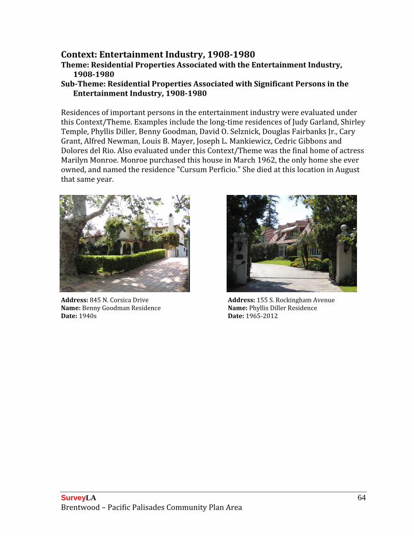
SurveyLA 64 Brentwood – Pacific Palisades Community Plan Area
Context: Entertainment Industry, 1908-1980 Theme: Residential Properties Associated with the Entertainment Industry,
1908-1980 Sub-Theme: Residential Properties Associated with Significant Persons in the
Entertainment Industry, 1908-1980 Residences of important persons in the entertainment industry were evaluated under this Context/Theme. Examples include the long-time residences of Judy Garland, Shirley Temple, Phyllis Diller, Benny Goodman, David O. Selznick, Douglas Fairbanks Jr., Cary Grant, Alfred Newman, Louis B. Mayer, Joseph L. Mankiewicz, Cedric Gibbons and Dolores del Rio. Also evaluated under this Context/Theme was the final home of actress Marilyn Monroe. Monroe purchased this house in March 1962, the only home she ever owned, and named the residence "Cursum Perficio." She died at this location in August that same year.
Address: 845 N. Corsica Drive Address: 155 S. Rockingham Avenue Name: Benny Goodman Residence Name: Phyllis Diller Residence Date: 1940s Date: 1965-2012

SurveyLA 65 Brentwood – Pacific Palisades Community Plan Area
Context: Other Context, 1850-1980 Theme: Event or Series of Events, 1850-1980 The Other Context is used to capture unusual or unique property types for which a specific theme has not been developed. In Brentwood, this Context/Theme was used to evaluate a former Nike Missile site near Mulholland Drive atop San Vicente Peak. Nike Missile Control Site LA-96 is an anti-aircraft defense installation that was operated by the U.S. Army from 1956 to 1968. This site contained ground-based radar and computer systems designed to detect and track hostile aircraft and guide anti-aircraft missiles that would be launched from nearby Nike Missile Launch Site in the Sepulveda Basin. This site is now open to the public as a Cold War memorial park. Features include a guard shack, radar towers, water tanks, an underground bunker, a helicopter pad, and security fencing.
Address: 17500 Mulholland Drive Address: 17500 Mulholland Drive Name: Nike Missile Control Site LA-96 Name: Nike Missile Control Site LA-96 Date: 1956-1968 Date: 1956-1968
This Context/Theme was also used to evaluate the Uplifters Historic District, a unique early-20th century development of rustic cabins in the Rustic Canyon area of Pacific Palisades, called “Uplifters Ranch.” The Uplifters were a selective social club that had grown out of the Los Angeles Athletic Club. Established in 1913, it was a smaller, more select group with the intention to “uplift art, promote good fellowship, and build a closer acquaintance” among members. In 1920, members purchased the Rustic Canyon property for the year-round recreational use of its members. A number of original Uplifters residences remain on the site today, tucked in amongst later development. Original residences were constructed primarily in the mid-1920s, and exhibit a variety of rustic styles, including Craftsman bungalows and vernacular log-faced cabins. Also in the district is the Spanish Colonial Revival-style Uplifters Clubhouse (now the Rustic Canyon Recreation Center), a designated Historic-Cultural Monument. Additional district features include streets

SurveyLA 66 Brentwood – Pacific Palisades Community Plan Area
which follow the natural contours of the landscape, intermittent curbs faced with concrete or cobblestone, cobblestone retaining walls, the absence of sidewalks and streetlights, and lush natural landscaping with many mature trees. A period wooden sign for Uplifters Ranch is suspended over Latimer Road, marking the original entrance to the site.
District: Uplifters Historic District District: Uplifters Historic District Description: Street view Description: Street view
District: Uplifters Historic District District: Uplifters Historic District Address: 3 N. Latimer Road Address: 36 N. Haldeman Road Date: 1924 Date: 1924

SurveyLA 67 Brentwood – Pacific Palisades Community Plan Area
Context: Other Context, 1850-1980 Theme: Important Persons/Individuals, 1850-1980 The Other Context is used to capture unusual or unique property types for which a specific theme had not been developed. In this survey area, this Context/Theme was used to evaluate residences associated with important people for whom specific themes have not been developed. Examples include the residences of long-time USC president Rufus Von KleinSmid, Arts & Architecture magazine publisher John Entenza, and Pacific Palisades founder Rev. Charles Scott. Also evaluated under this Context/Theme were residences associated with the European Jewish émigré community that developed on the Westside of Los Angeles during and after World War II. Members included Austrian composer and painter Arnold Schoenberg, German writer and Nobel laureate Thomas Mann, and actress and screenwriter Salka Viertel.
Address: 116 N. Rockingham Avenue Address: 475 N. Mesa Road Name: Arnold Schoenberg Residence Name: John Entenza Residence Date: 1936-1951 Date: 1937-1949
Address: 631 N. Via de la Paz Name: Rev. Charles Scott Residence Date: 1923-1927

SurveyLA 68 Brentwood – Pacific Palisades Community Plan Area
Context: Other Context, 1850-1980 Theme: Design/Construction, 1850-1980 The Other Context was used to capture unusual or unique property types for which a specific theme had not been developed. In this survey area, this Context/Theme was used to evaluate three concrete bridges over the Los Angeles River in Pacific Palisades, as intact examples of 1940s public works civic improvement projects. Also evaluated under this Context/Theme is a concrete tunnel that allows Rustic Creek to flow underneath Sunset Boulevard. This tunnel appears to be located on what was once part of the Will Rogers Estate; it replaced the original bridge and tunnel that washed out in 1934.
Location: Rustic Creek under Sunset Location: Pacific Coast Highway over Rustic Boulevard Creek Name: Rustic Creek/Sunset Boulevard Name: Pacific Coast Highway/Rustic Creek Tunnel Bridge Date: circa 1935 Date: circa 1940
Location: Channel Lane over Rustic Creek Location: Short Street over Rustic Creek Name: Channel Lane/Rustic Creek Bridge Name: Short Street/Rustic Creek Date: circa 1940 Date: circa 1940

SurveyLA 69 Brentwood – Pacific Palisades Community Plan Area
For Further Reading The following is a list of general sources on the history and development of Brentwood and Pacific Palisades. This list is not comprehensive but is being provided for informational purposes. Basten, Fred E. Santa Monica Bay: The First 100 Years. Los Angeles: Douglas-West Publishers, 1974.
Loomis, Jan. Images of America: Brentwood. Charleston, South Carolina et al: Arcadia Publishing, 2008.
Loomis, Jan. Images of America: Pacific Palisades. Charleston, South Carolina: Arcadia Publishing, 2009.
Loomis, Jan. Westside Chronicles: Historic Stories of West Los Angeles. Charleston, South Carolina: The History Press, 2012.
Young, Betty Lou. Rustic Canyon and the Story of the Uplifters. Santa Monica: Casa Vieja Press, 1975.
Young, Betty Lou. Our First Century: The Los Angeles Athletic Club, 1880-1980. Los Angeles: LAAC Press, 1979.
Young, Betty Lou. Pacific Palisades: Where the Mountains Meet the Sea. Pacific Palisades: Pacific Palisades Historical Society Press, 1983.
Young, Betty Lou and Randy Young. Santa Monica Canyon: A Walk Through History. Pacific Palisades: Casa Vieja Press, 1998.
Young, Randy and Betty Lou Young. Street Names of Pacific Palisades and Other Tales. Pacific Palisades: Pacific Palisades Historical Society Press, 1990.