HISTORIC PRESERVATION RECOMMENDATIONS … District...1 PHILADELPHIA HISTORICAL COMMISSION HISTORIC...
56
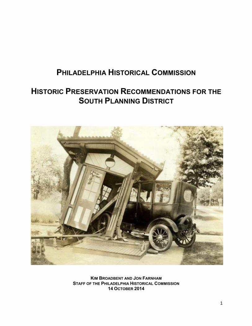
1 PHILADELPHIA HISTORICAL COMMISSION HISTORIC PRESERVATION RECOMMENDATIONS FOR THE SOUTH PLANNING DISTRICT KIM BROADBENT AND JON FARNHAM STAFF OF THE PHILADELPHIA HISTORICAL COMMISSION 14 OCTOBER 2014
Transcript of HISTORIC PRESERVATION RECOMMENDATIONS … District...1 PHILADELPHIA HISTORICAL COMMISSION HISTORIC...
1
PHILADELPHIA HISTORICAL COMMISSION
HISTORIC PRESERVATION RECOMMENDATIONS FOR THE
SOUTH PLANNING DISTRICT
KIM BROADBENT AND JON FARNHAM STAFF OF THE PHILADELPHIA HISTORICAL COMMISSION
14 OCTOBER 2014
2
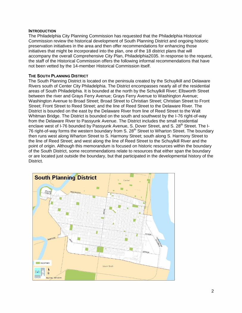
INTRODUCTION The Philadelphia City Planning Commission has requested that the Philadelphia Historical Commission review the historical development of South Planning District and ongoing historic preservation initiatives in the area and then offer recommendations for enhancing those initiatives that might be incorporated into the plan, one of the 18 district plans that will accompany the overall Comprehensive City Plan, Philadelphia2035. In response to the request, the staff of the Historical Commission offers the following informal recommendations that have not been vetted by the 14-member Historical Commission itself. THE SOUTH PLANNING DISTRICT The South Planning District is located on the peninsula created by the Schuylkill and Delaware Rivers south of Center City Philadelphia. The District encompasses nearly all of the residential areas of South Philadelphia. It is bounded at the north by the Schuylkill River; Ellsworth Street between the river and Grays Ferry Avenue; Grays Ferry Avenue to Washington Avenue; Washington Avenue to Broad Street; Broad Street to Christian Street; Christian Street to Front Street; Front Street to Reed Street; and the line of Reed Street to the Delaware River. The District is bounded on the east by the Delaware River from line of Reed Street to the Walt Whitman Bridge. The District is bounded on the south and southwest by the I-76 right-of-way from the Delaware River to Passyunk Avenue. The District includes the small residential enclave west of I-76 bounded by Passyunk Avenue, S. Dover Street, and S. 28th Street. The I-76 right-of-way forms the western boundary from S. 28th Street to Wharton Street. The boundary then runs west along Wharton Street to S. Harmony Street; south along S. Harmony Street to the line of Reed Street; and west along the line of Reed Street to the Schuylkill River and the point of origin. Although this memorandum is focused on historic resources within the boundary of the South District, some recommendations relate to resources that either span the boundary or are located just outside the boundary, but that participated in the developmental history of the District.
3
CURRENT HISTORIC PRESERVATION ACTIVITIES IN THE SOUTH PLANNING DISTRICT Created by City Council ordinance in 1955, reorganized in 1985, and reorganized again under Section 14-1000 of the Philadelphia Code in 2012, the Philadelphia Historical Commission is responsible for ensuring the preservation of historically significant buildings, structures, sites, objects, interiors, and districts in the city. The Commission identifies and designates historic resources, listing them on the Philadelphia Register of Historic Places, and then regulates those resources for preservation through the City’s building and other permitting processes. Within the South Planning District, 682 properties (excluding condominium units) are listed on the Philadelphia Register. There are approximately 12,000 properties (23,000 if condominium units are included) in total on the Philadelphia Register of Historic Places. The addresses of the historically-designated properties in the South Planning District are provided in an appendix. Currently, there is one historic district within South Planning District listed on the Philadelphia Register, the Girard Estate Historic District. The National Park Service, a federal agency, and the Pennsylvania Historical & Museum Commission, a state agency, maintain the National Register of Historic Places in the Commonwealth of Pennsylvania. The federal and state governments protect historic resources by factoring historic preservation into their decision-making whenever they are involved with construction projects directly or through funding, permits, licenses, or other indirect means that may impact historic resources listed on and eligible for the National Register. Two National Register Historic Districts are located within the South Planning District, the Southwark Historic District and the Washington Avenue Historic District. The addresses located within these districts are included in the appendix. The following public school buildings within the South Planning District are listed on the National Register as elements of the Philadelphia Public Schools Thematic Historic District.
2136 Ritner Street, Edgar Allen Poe School
2700 Morris Street, Anthony Wayne School - converted to senior housing
1501 S 17th Street, George W. Childs School
1801 S 22nd Street, Delaplaine McDaniel Public School
2102 S 24th Street, Edwin H. Vare Junior High School
1700 Bigler Street, F. Amadee Bregy Public School
3200 Dickinson Street, James Alcorn School
1900 Wharton Street, Walter George Smith Public School
1235 S 16th Street, Norris S. Barrett/Jeremiah Nichols School
1201 S 23rd Street, David Landreth School
1501 S 7th Street, Eliza B. Kirkbride School
1150 Wharton Street, James Wilson Public School; Annunciation BVM
1213 S 12th Street, Federal Street School; Andrew Jackson School
1198 S 5th Street, George Washington Public School
627 Carpenter Street, George W. Nebinger Public School
1621 E Moyamensing Ave, Abigail Vare School
1821 S 9th Street, Southwark School
1901 S 9th Street, Edward Bok Vocational School
1900 S 3rd Street, Horace Howard Furness Public School
2250 S 8th Street, Francis Scott Key School
2300 S 2nd Street, George Sharswood School
4
900 Oregon Ave, D. Newlin Fell School
2746 S 9th Street, George C. Thomas School The following buildings within the South Planning District are listed individually on the National Register.
2724 S 20th Street, Defense Personnel Support Center; Philadelphia Quartermaster Depot; Army Quartermasters Inland Warehouse
1429 Snyder Avenue, Baptist Institute for Christian Workers
1100 S. Broad Street, Marine Corps Supply Activity
904-38 S. Swanson Street, Gloria Dei; Old Swede's Church
5
PRESERVATION RECOMMENDATIONS The staff of the Historical Commission has preliminarily surveyed the Planning District and finds that there are many significant residential, recreational, institutional, commercial, and industrial sites that satisfy one or more Criteria for Designation to the Philadelphia Register of Historic Places as outlined in the historic preservation ordinance, Section 14-1000 of the Philadelphia Code. Given the cursory nature of this survey, priorities for consideration for designation have not been assigned to the potential historic resources. Historic resources that may satisfy one or more Criteria for Designation are called out in the following summary of the developmental history of the South District and, for clarity, are also listed in an appendix. Early Inhabitants The first inhabitants of the Philadelphia region, the ancestors of the Lenape, arrived between 10,000 and 12,000 years ago. Widely scattered and migratory, the first inhabitants lived primarily along the edges of rivers in places that have likely been submerged since the end of the Ice Age. The climate in the Philadelphia area stabilized about 2,800 years ago, leaving a landscape that persisted until the interventions of the last few centuries. After the climate stabilized, the Native American peoples in the region became more sedentary and developed agricultural systems and permanent settlements. By the early sixteenth century and the arrival of the first Europeans in the Mid Atlantic region, the Lenape, Native Americans with a common language, customs, and heritage, lived in a dozen or more bands or groups in what is now southeastern Pennsylvania. Two of these bands, the Passyunk and the Wequiaquenske, inhabited territories in what is now South Philadelphia. The Passyunk occupied a territory on the eastern bank of the Schuylkill River, north of its confluence with the Delaware River. Passyunk means “In the Valley.” The Wequiaquenske occupied a territory on the western bank of the Delaware River, north of Hollander Creek, where Southwark and Pennsport are now located. Wequiaquenske, also known as Wicaco, likely means “Place of Pine Trees at the Head of a Creek.” Feeling the pressures of European settlement, most Lenape bands moved inland in the late seventeenth and early eighteenth centuries. By the 1730s, the Lenape had moved to central and western Pennsylvania. Although archaeological evidence of the Lenape inhabitation of the South District undoubtedly survives, no above-ground artifacts of the Native American settlements exist. European Settlement Europeans explored and settled the Delaware Valley in the sixteenth and seventeenth centuries. Verrazano may have navigated the Delaware as early as 1524. European traders and trappers likely ventured up the Delaware in the second half of the sixteenth century, but none settled. Henry Hudson visited Delaware Bay in 1609. In 1624, the Dutch West Indian Company established a small settlement at what is now Burlington, New Jersey, about 15 miles northeast of Philadelphia on the Delaware River. Two years later, the Dutch built Fort Nassau on the east bank of the Delaware, at what is now Gloucester, New Jersey, opposite South Philadelphia. The Dutch established small trading posts on the Delaware, but they did not colonize the area. The Swedes, who arrived not long after the Dutch, did colonize the lands along the west bank of the Delaware, founding New Sweden in 1638 at Fort Christina, at present-day Wilmington, Delaware. In 1643, Johan Printz, the third Swedish colonial governor, built Printzhof, a fortified log house, on Tinicum Island, near the present site of the Philadelphia International Airport. In 1648, the Dutch built Fort Beversreede, a palisaded log fort, on the east bank of the Schuylkill at its mouth, at the southwestern corner of what is now South Philadelphia. In response, the Swedes erected a stockade directly in front of the Dutch fort. New Sweden persisted until 1655, when the Dutch conquered the colony and renamed it New Netherland. The Dutch colony of
6
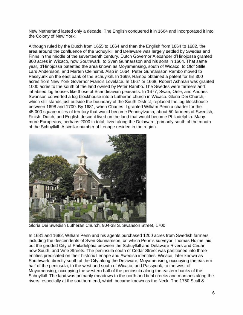
New Netherland lasted only a decade. The English conquered it in 1664 and incorporated it into the Colony of New York. Although ruled by the Dutch from 1655 to 1664 and then the English from 1664 to 1682, the area around the confluence of the Schuylkill and Delaware was largely settled by Swedes and Finns in the middle of the seventeenth century. Dutch Governor Alexander d’Hinojossa granted 800 acres in Wicaco, now Southwark, to Sven Gunnarsson and his sons in 1664. That same year, d’Hinojossa patented the area known as Moyamensing, south of Wicaco, to Olof Stille, Lars Andersson, and Marten Cleinsmit. Also in 1664, Peter Gunnarsson Rambo moved to Passyunk on the east bank of the Schuylkill. In 1669, Rambo obtained a patent for his 300 acres from New York Governor Francis Lovelace. In 1667 or 1668, Robert Ashman was granted 1000 acres to the south of the land owned by Peter Rambo. The Swedes were farmers and inhabited log houses like those of Scandinavian peasants. In 1677, Swan, Oele, and Andries Swanson converted a log blockhouse into a Lutheran church in Wicaco. Gloria Dei Church, which still stands just outside the boundary of the South District, replaced the log blockhouse between 1698 and 1700. By 1681, when Charles II granted William Penn a charter for the 45,000 square miles of territory that would become Pennsylvania, about 50 farmers of Swedish, Finish, Dutch, and English descent lived on the land that would become Philadelphia. Many more Europeans, perhaps 2000 in total, lived along the Delaware, primarily south of the mouth of the Schuylkill. A similar number of Lenape resided in the region.
Gloria Dei Swedish Lutheran Church, 904-38 S. Swanson Street, 1700 In 1681 and 1682, William Penn and his agents purchased 1200 acres from Swedish farmers including the descendents of Sven Gunnarsson, on which Penn’s surveyor Thomas Holme laid out the gridded City of Philadelphia between the Schuylkill and Delaware Rivers and Cedar, now South, and Vine Streets. The peninsula south of Cedar Street was partitioned into three entities predicated on their historic Lenape and Swedish identities: Wicaco, later known as Southwark, directly south of the City along the Delaware; Moyamensing, occupying the eastern half of the peninsula, to the west and south of Wicaco; and Passyunk, to the west of Moyamensing, occupying the western half of the peninsula along the eastern banks of the Schuylkill. The land was primarily meadows to the north and tidal creeks and marshes along the rivers, especially at the southern end, which became known as the Neck. The 1750 Scull &
7
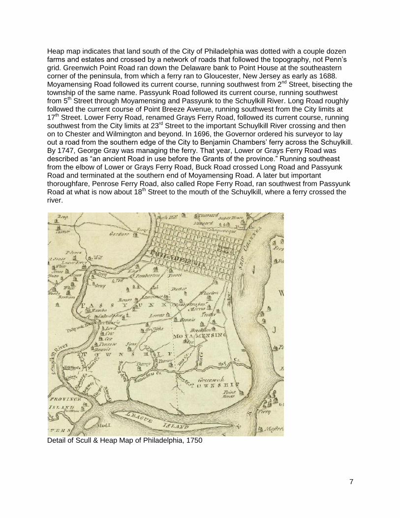
Heap map indicates that land south of the City of Philadelphia was dotted with a couple dozen farms and estates and crossed by a network of roads that followed the topography, not Penn’s grid. Greenwich Point Road ran down the Delaware bank to Point House at the southeastern corner of the peninsula, from which a ferry ran to Gloucester, New Jersey as early as 1688. Moyamensing Road followed its current course, running southwest from 2nd Street, bisecting the township of the same name. Passyunk Road followed its current course, running southwest from 5th Street through Moyamensing and Passyunk to the Schuylkill River. Long Road roughly followed the current course of Point Breeze Avenue, running southwest from the City limits at 17th Street. Lower Ferry Road, renamed Grays Ferry Road, followed its current course, running southwest from the City limits at 23rd Street to the important Schuylkill River crossing and then on to Chester and Wilmington and beyond. In 1696, the Governor ordered his surveyor to lay out a road from the southern edge of the City to Benjamin Chambers’ ferry across the Schuylkill. By 1747, George Gray was managing the ferry. That year, Lower or Grays Ferry Road was described as “an ancient Road in use before the Grants of the province.” Running southeast from the elbow of Lower or Grays Ferry Road, Buck Road crossed Long Road and Passyunk Road and terminated at the southern end of Moyamensing Road. A later but important thoroughfare, Penrose Ferry Road, also called Rope Ferry Road, ran southwest from Passyunk Road at what is now about 18th Street to the mouth of the Schuylkill, where a ferry crossed the river.
Detail of Scull & Heap Map of Philadelphia, 1750
8
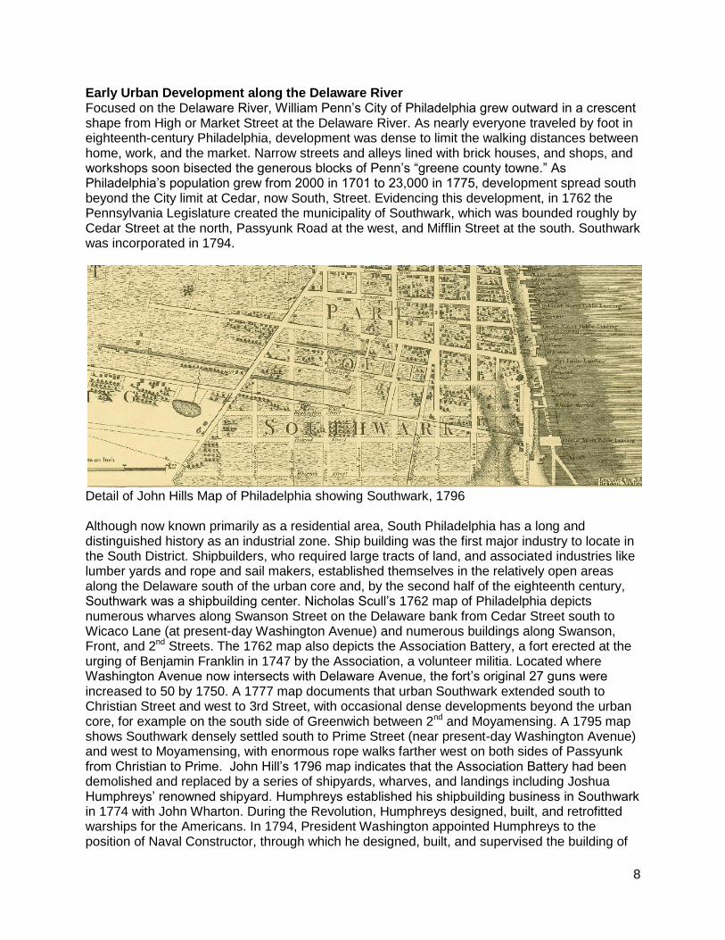
Early Urban Development along the Delaware River Focused on the Delaware River, William Penn’s City of Philadelphia grew outward in a crescent shape from High or Market Street at the Delaware River. As nearly everyone traveled by foot in eighteenth-century Philadelphia, development was dense to limit the walking distances between home, work, and the market. Narrow streets and alleys lined with brick houses, and shops, and workshops soon bisected the generous blocks of Penn’s “greene county towne.” As Philadelphia’s population grew from 2000 in 1701 to 23,000 in 1775, development spread south beyond the City limit at Cedar, now South, Street. Evidencing this development, in 1762 the Pennsylvania Legislature created the municipality of Southwark, which was bounded roughly by Cedar Street at the north, Passyunk Road at the west, and Mifflin Street at the south. Southwark was incorporated in 1794.
Detail of John Hills Map of Philadelphia showing Southwark, 1796 Although now known primarily as a residential area, South Philadelphia has a long and distinguished history as an industrial zone. Ship building was the first major industry to locate in the South District. Shipbuilders, who required large tracts of land, and associated industries like lumber yards and rope and sail makers, established themselves in the relatively open areas along the Delaware south of the urban core and, by the second half of the eighteenth century, Southwark was a shipbuilding center. Nicholas Scull’s 1762 map of Philadelphia depicts numerous wharves along Swanson Street on the Delaware bank from Cedar Street south to Wicaco Lane (at present-day Washington Avenue) and numerous buildings along Swanson, Front, and 2nd Streets. The 1762 map also depicts the Association Battery, a fort erected at the urging of Benjamin Franklin in 1747 by the Association, a volunteer militia. Located where Washington Avenue now intersects with Delaware Avenue, the fort’s original 27 guns were increased to 50 by 1750. A 1777 map documents that urban Southwark extended south to Christian Street and west to 3rd Street, with occasional dense developments beyond the urban core, for example on the south side of Greenwich between 2nd and Moyamensing. A 1795 map shows Southwark densely settled south to Prime Street (near present-day Washington Avenue) and west to Moyamensing, with enormous rope walks farther west on both sides of Passyunk from Christian to Prime. John Hill’s 1796 map indicates that the Association Battery had been demolished and replaced by a series of shipyards, wharves, and landings including Joshua Humphreys’ renowned shipyard. Humphreys established his shipbuilding business in Southwark in 1774 with John Wharton. During the Revolution, Humphreys designed, built, and retrofitted warships for the Americans. In 1794, President Washington appointed Humphreys to the position of Naval Constructor, through which he designed, built, and supervised the building of
9
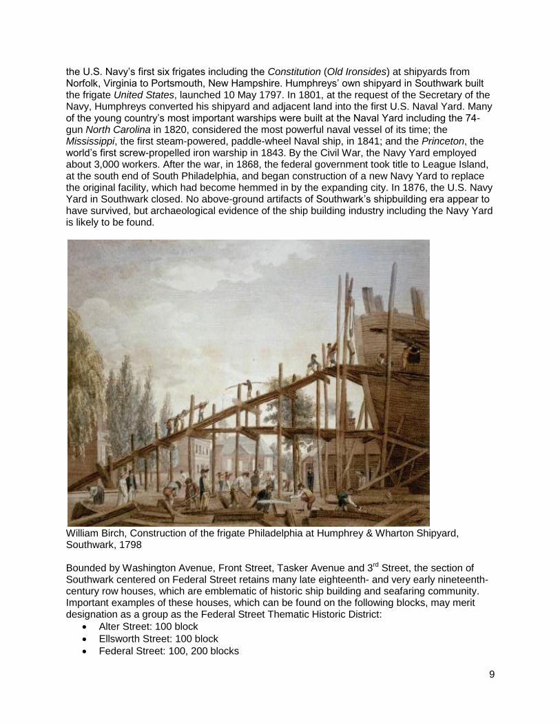
the U.S. Navy’s first six frigates including the Constitution (Old Ironsides) at shipyards from Norfolk, Virginia to Portsmouth, New Hampshire. Humphreys’ own shipyard in Southwark built the frigate United States, launched 10 May 1797. In 1801, at the request of the Secretary of the Navy, Humphreys converted his shipyard and adjacent land into the first U.S. Naval Yard. Many of the young country’s most important warships were built at the Naval Yard including the 74-gun North Carolina in 1820, considered the most powerful naval vessel of its time; the Mississippi, the first steam-powered, paddle-wheel Naval ship, in 1841; and the Princeton, the world’s first screw-propelled iron warship in 1843. By the Civil War, the Navy Yard employed about 3,000 workers. After the war, in 1868, the federal government took title to League Island, at the south end of South Philadelphia, and began construction of a new Navy Yard to replace the original facility, which had become hemmed in by the expanding city. In 1876, the U.S. Navy Yard in Southwark closed. No above-ground artifacts of Southwark’s shipbuilding era appear to have survived, but archaeological evidence of the ship building industry including the Navy Yard is likely to be found.
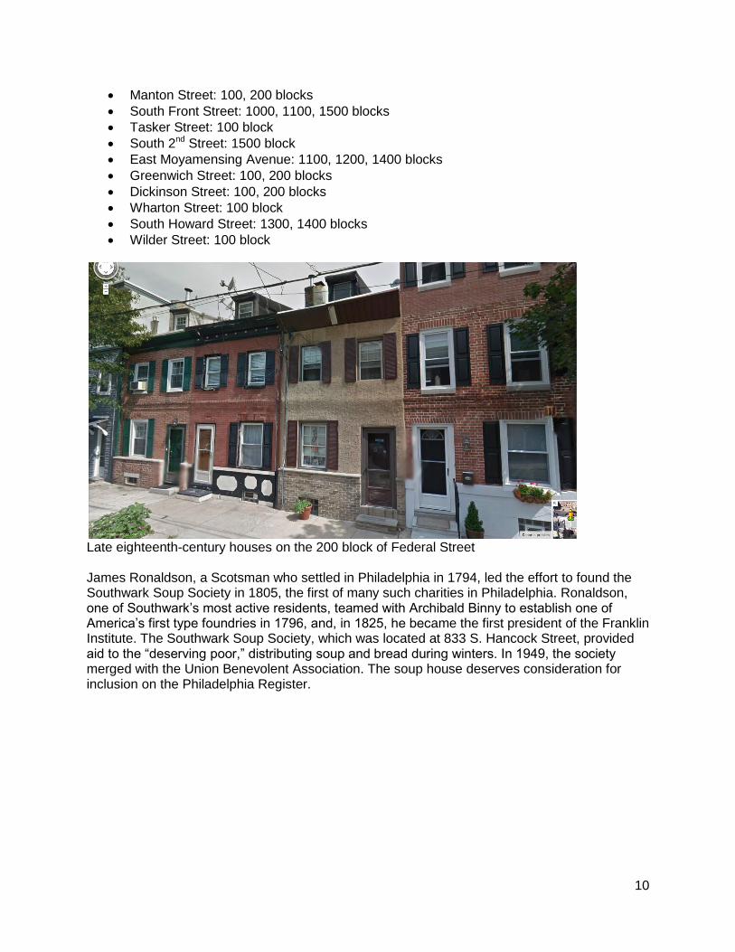
William Birch, Construction of the frigate Philadelphia at Humphrey & Wharton Shipyard, Southwark, 1798 Bounded by Washington Avenue, Front Street, Tasker Avenue and 3rd Street, the section of Southwark centered on Federal Street retains many late eighteenth- and very early nineteenth-century row houses, which are emblematic of historic ship building and seafaring community. Important examples of these houses, which can be found on the following blocks, may merit designation as a group as the Federal Street Thematic Historic District:
Alter Street: 100 block
Ellsworth Street: 100 block
Federal Street: 100, 200 blocks
10
Manton Street: 100, 200 blocks
South Front Street: 1000, 1100, 1500 blocks
Tasker Street: 100 block
South 2nd Street: 1500 block
East Moyamensing Avenue: 1100, 1200, 1400 blocks
Greenwich Street: 100, 200 blocks
Dickinson Street: 100, 200 blocks
Wharton Street: 100 block
South Howard Street: 1300, 1400 blocks
Wilder Street: 100 block
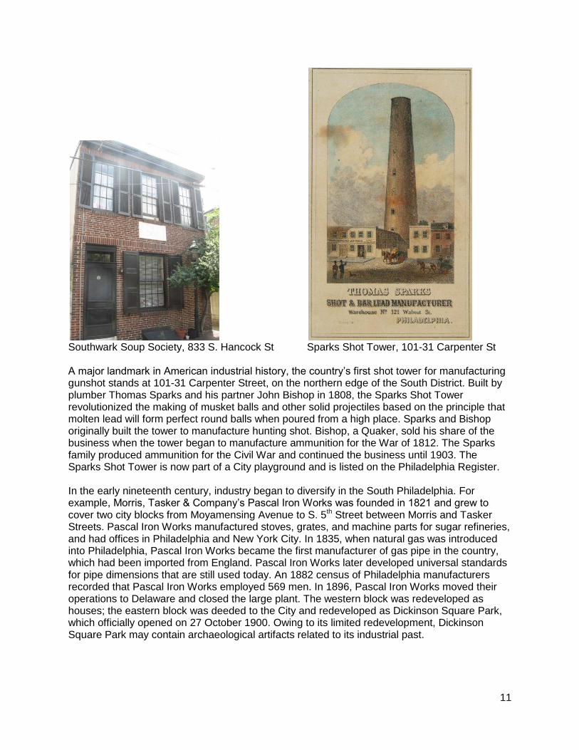
Late eighteenth-century houses on the 200 block of Federal Street James Ronaldson, a Scotsman who settled in Philadelphia in 1794, led the effort to found the Southwark Soup Society in 1805, the first of many such charities in Philadelphia. Ronaldson, one of Southwark’s most active residents, teamed with Archibald Binny to establish one of America’s first type foundries in 1796, and, in 1825, he became the first president of the Franklin Institute. The Southwark Soup Society, which was located at 833 S. Hancock Street, provided aid to the “deserving poor,” distributing soup and bread during winters. In 1949, the society merged with the Union Benevolent Association. The soup house deserves consideration for inclusion on the Philadelphia Register.
11
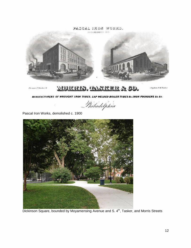
Southwark Soup Society, 833 S. Hancock St Sparks Shot Tower, 101-31 Carpenter St A major landmark in American industrial history, the country’s first shot tower for manufacturing gunshot stands at 101-31 Carpenter Street, on the northern edge of the South District. Built by plumber Thomas Sparks and his partner John Bishop in 1808, the Sparks Shot Tower revolutionized the making of musket balls and other solid projectiles based on the principle that molten lead will form perfect round balls when poured from a high place. Sparks and Bishop originally built the tower to manufacture hunting shot. Bishop, a Quaker, sold his share of the business when the tower began to manufacture ammunition for the War of 1812. The Sparks family produced ammunition for the Civil War and continued the business until 1903. The Sparks Shot Tower is now part of a City playground and is listed on the Philadelphia Register. In the early nineteenth century, industry began to diversify in the South Philadelphia. For example, Morris, Tasker & Company’s Pascal Iron Works was founded in 1821 and grew to cover two city blocks from Moyamensing Avenue to S. 5th Street between Morris and Tasker Streets. Pascal Iron Works manufactured stoves, grates, and machine parts for sugar refineries, and had offices in Philadelphia and New York City. In 1835, when natural gas was introduced into Philadelphia, Pascal Iron Works became the first manufacturer of gas pipe in the country, which had been imported from England. Pascal Iron Works later developed universal standards for pipe dimensions that are still used today. An 1882 census of Philadelphia manufacturers recorded that Pascal Iron Works employed 569 men. In 1896, Pascal Iron Works moved their operations to Delaware and closed the large plant. The western block was redeveloped as houses; the eastern block was deeded to the City and redeveloped as Dickinson Square Park, which officially opened on 27 October 1900. Owing to its limited redevelopment, Dickinson Square Park may contain archaeological artifacts related to its industrial past.
12
Pascal Iron Works, demolished c. 1900
Dickinson Square, bounded by Moyamensing Avenue and S. 4th, Tasker, and Morris Streets
13
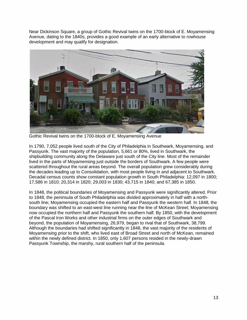
Near Dickinson Square, a group of Gothic Revival twins on the 1700-block of E. Moyamensing Avenue, dating to the 1840s, provides a good example of an early alternative to rowhouse development and may qualify for designation.
Gothic Revival twins on the 1700-block of E. Moyamensing Avenue In 1790, 7,052 people lived south of the City of Philadelphia in Southwark, Moyamensing, and Passyunk. The vast majority of the population, 5,661 or 80%, lived in Southwark, the shipbuilding community along the Delaware just south of the City line. Most of the remainder lived in the parts of Moyamensing just outside the borders of Southwark. A few people were scattered throughout the rural areas beyond. The overall population grew considerably during the decades leading up to Consolidation, with most people living in and adjacent to Southwark. Decadal census counts show constant population growth in South Philadelphia: 12,097 in 1800; 17,586 in 1810; 20,314 in 1820; 29,003 in 1830; 43,715 in 1840; and 67,385 in 1850. In 1848, the political boundaries of Moyamensing and Passyunk were significantly altered. Prior to 1848, the peninsula of South Philadelphia was divided approximately in half with a north-south line; Moyamensing occupied the eastern half and Passyunk the western half. In 1848, the boundary was shifted to an east-west line running near the line of McKean Street; Moyamensing now occupied the northern half and Passyunk the southern half. By 1850, with the development of the Pascal Iron Works and other industrial firms on the outer edges of Southwark and beyond, the population of Moyamensing, 26,979, began to rival that of Southwark, 38,799. Although the boundaries had shifted significantly in 1848, the vast majority of the residents of Moyamensing prior to the shift, who lived east of Broad Street and north of McKean, remained within the newly defined district. In 1850, only 1,607 persons resided in the newly-drawn Passyunk Township, the marshy, rural southern half of the peninsula.
14
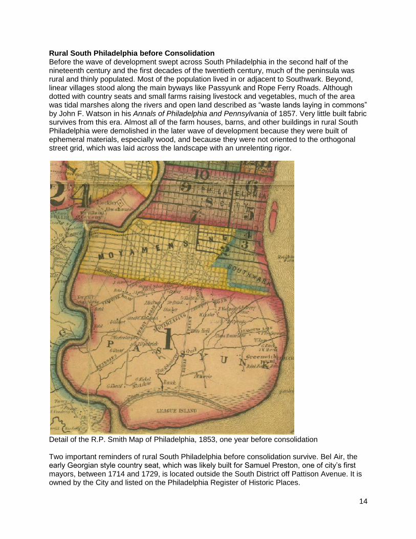
Rural South Philadelphia before Consolidation Before the wave of development swept across South Philadelphia in the second half of the nineteenth century and the first decades of the twentieth century, much of the peninsula was rural and thinly populated. Most of the population lived in or adjacent to Southwark. Beyond, linear villages stood along the main byways like Passyunk and Rope Ferry Roads. Although dotted with country seats and small farms raising livestock and vegetables, much of the area was tidal marshes along the rivers and open land described as “waste lands laying in commons” by John F. Watson in his Annals of Philadelphia and Pennsylvania of 1857. Very little built fabric survives from this era. Almost all of the farm houses, barns, and other buildings in rural South Philadelphia were demolished in the later wave of development because they were built of ephemeral materials, especially wood, and because they were not oriented to the orthogonal street grid, which was laid across the landscape with an unrelenting rigor.
Detail of the R.P. Smith Map of Philadelphia, 1853, one year before consolidation Two important reminders of rural South Philadelphia before consolidation survive. Bel Air, the early Georgian style country seat, which was likely built for Samuel Preston, one of city’s first mayors, between 1714 and 1729, is located outside the South District off Pattison Avenue. It is owned by the City and listed on the Philadelphia Register of Historic Places.
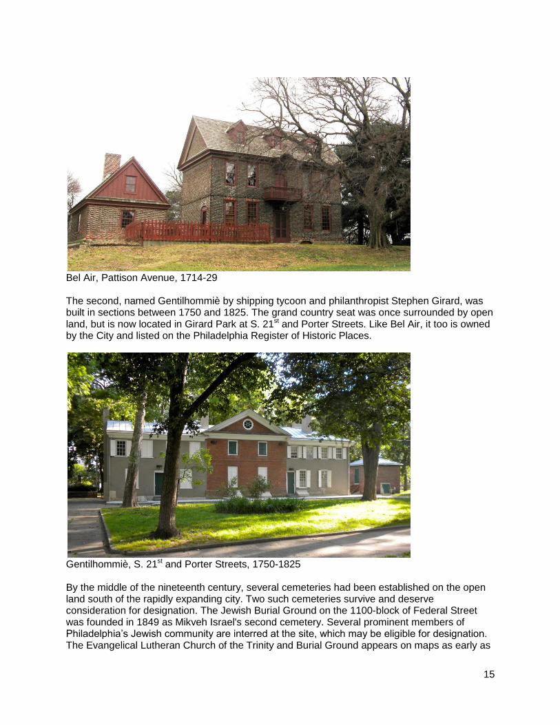
15
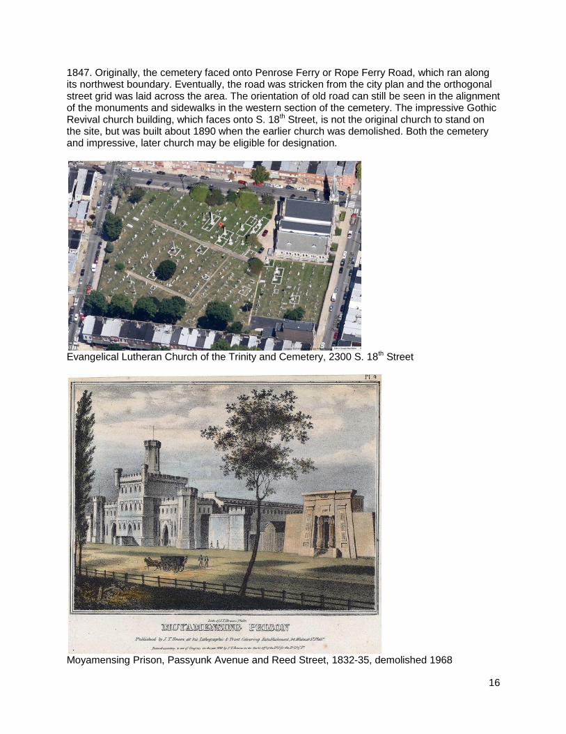
Bel Air, Pattison Avenue, 1714-29 The second, named Gentilhommiè by shipping tycoon and philanthropist Stephen Girard, was built in sections between 1750 and 1825. The grand country seat was once surrounded by open land, but is now located in Girard Park at S. 21st and Porter Streets. Like Bel Air, it too is owned by the City and listed on the Philadelphia Register of Historic Places.
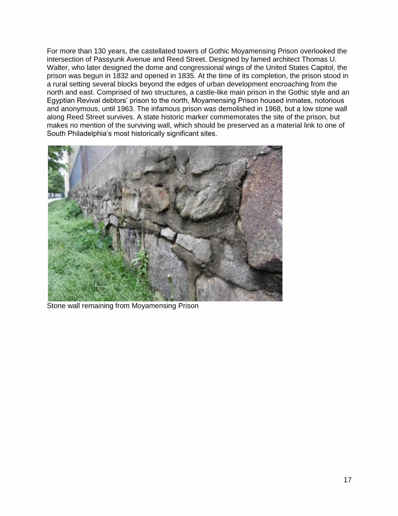
Gentilhommiè, S. 21st and Porter Streets, 1750-1825 By the middle of the nineteenth century, several cemeteries had been established on the open land south of the rapidly expanding city. Two such cemeteries survive and deserve consideration for designation. The Jewish Burial Ground on the 1100-block of Federal Street was founded in 1849 as Mikveh Israel's second cemetery. Several prominent members of Philadelphia’s Jewish community are interred at the site, which may be eligible for designation. The Evangelical Lutheran Church of the Trinity and Burial Ground appears on maps as early as
16
1847. Originally, the cemetery faced onto Penrose Ferry or Rope Ferry Road, which ran along its northwest boundary. Eventually, the road was stricken from the city plan and the orthogonal street grid was laid across the area. The orientation of old road can still be seen in the alignment of the monuments and sidewalks in the western section of the cemetery. The impressive Gothic Revival church building, which faces onto S. 18th Street, is not the original church to stand on the site, but was built about 1890 when the earlier church was demolished. Both the cemetery and impressive, later church may be eligible for designation.
Evangelical Lutheran Church of the Trinity and Cemetery, 2300 S. 18th Street
Moyamensing Prison, Passyunk Avenue and Reed Street, 1832-35, demolished 1968
17
For more than 130 years, the castellated towers of Gothic Moyamensing Prison overlooked the intersection of Passyunk Avenue and Reed Street. Designed by famed architect Thomas U. Walter, who later designed the dome and congressional wings of the United States Capitol, the prison was begun in 1832 and opened in 1835. At the time of its completion, the prison stood in a rural setting several blocks beyond the edges of urban development encroaching from the north and east. Comprised of two structures, a castle-like main prison in the Gothic style and an Egyptian Revival debtors’ prison to the north, Moyamensing Prison housed inmates, notorious and anonymous, until 1963. The infamous prison was demolished in 1968, but a low stone wall along Reed Street survives. A state historic marker commemorates the site of the prison, but makes no mention of the surviving wall, which should be preserved as a material link to one of South Philadelphia’s most historically significant sites.
Stone wall remaining from Moyamensing Prison

18
The Industrialization of South Philadelphia The introduction of railroads to South Philadelphia in the 1830s spurred industrial growth in the area. Chartered in 1831, the Southwark Rail-Road constructed tracks in 1835 along Broad Street from South Street to Washington Avenue, then known as Prime Street, and then east along Washington Avenue to the Delaware River. Also chartered in 1831, the Philadelphia and Delaware County Rail-Road Company merged with several other lines to become the Philadelphia, Wilmington & Baltimore Railroad (PW&B) in 1836. In December 1838, the PW&B completed its Schuylkill River bridge at Grays Ferry, allowing trains to run from downtown Philadelphia to downtown Baltimore, with the only break in the tracks at the Susquehanna River, where a ferry transported the rail cars. The PW&B tracks in South Philadelphia ran from the bridge at the Schuylkill along Grays Ferry Avenue and Washington Avenue to Broad Street. By the middle of the nineteenth century, the corridor along Washington and Grays Ferry Avenues was opened for industrial development.
Philadelphia, Wilmington & Baltimore Railroad Bridge over the Schuylkill River at Grays Ferry Although Washington Avenue and adjacent streets were once lined with manufacturing facilities tied into the rail lines, few survive. Four examples of the factories and mills stand in the Washington Avenue National Register Historic District, which includes the 1000 to 1300 blocks of Washington Avenue as well as the 1200 block of Carpenter Street. These buildings merit consideration for listing on the Philadelphia Register.
Curtis Publishing Company, 1101 Washington Avenue
American Cigar Company, 1135 Washington Avenue
John Wyeth Chemical Works, 1201-21 Washington Avenue
Main Belting Company, 1217-41 Carpenter Street
19
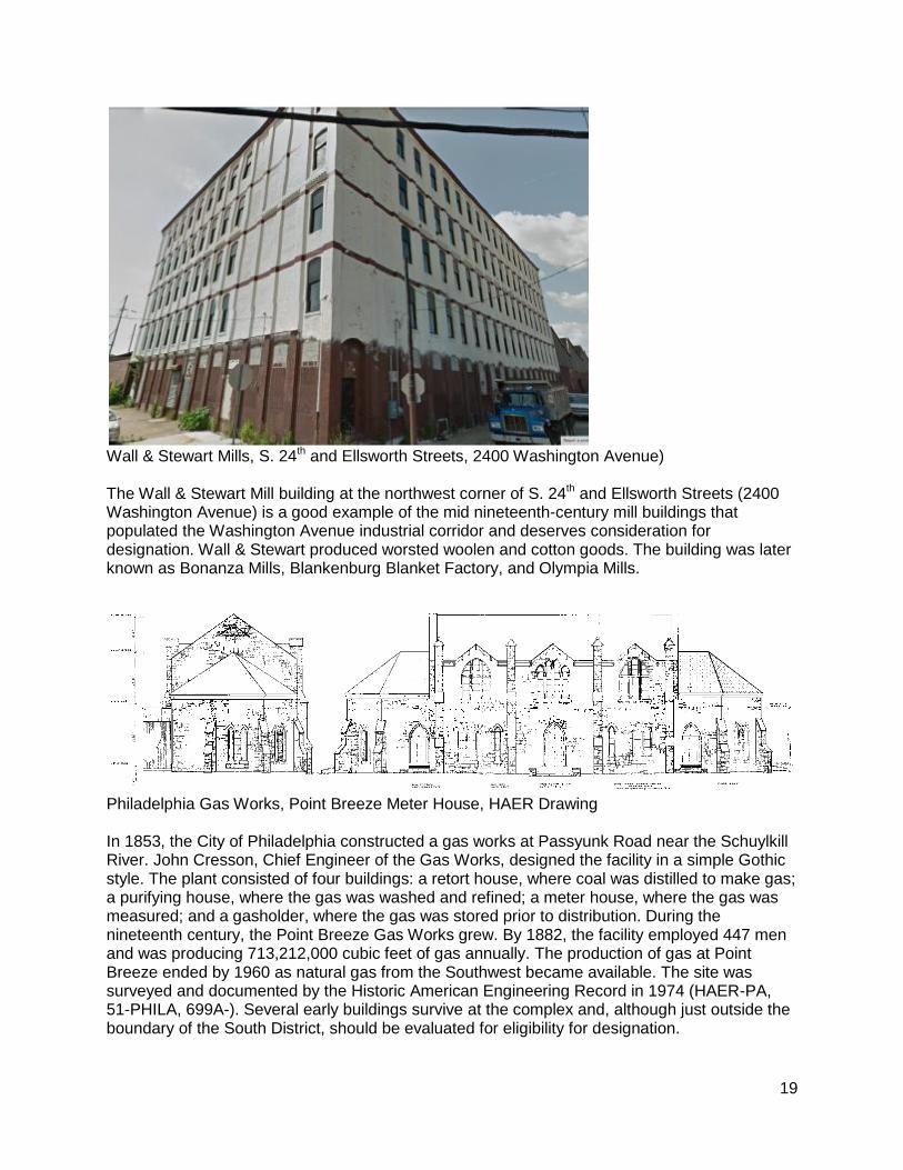
Wall & Stewart Mills, S. 24th and Ellsworth Streets, 2400 Washington Avenue) The Wall & Stewart Mill building at the northwest corner of S. 24th and Ellsworth Streets (2400 Washington Avenue) is a good example of the mid nineteenth-century mill buildings that populated the Washington Avenue industrial corridor and deserves consideration for designation. Wall & Stewart produced worsted woolen and cotton goods. The building was later known as Bonanza Mills, Blankenburg Blanket Factory, and Olympia Mills.
Philadelphia Gas Works, Point Breeze Meter House, HAER Drawing In 1853, the City of Philadelphia constructed a gas works at Passyunk Road near the Schuylkill River. John Cresson, Chief Engineer of the Gas Works, designed the facility in a simple Gothic style. The plant consisted of four buildings: a retort house, where coal was distilled to make gas; a purifying house, where the gas was washed and refined; a meter house, where the gas was measured; and a gasholder, where the gas was stored prior to distribution. During the nineteenth century, the Point Breeze Gas Works grew. By 1882, the facility employed 447 men and was producing 713,212,000 cubic feet of gas annually. The production of gas at Point Breeze ended by 1960 as natural gas from the Southwest became available. The site was surveyed and documented by the Historic American Engineering Record in 1974 (HAER-PA, 51-PHILA, 699A-). Several early buildings survive at the complex and, although just outside the boundary of the South District, should be evaluated for eligibility for designation.
20
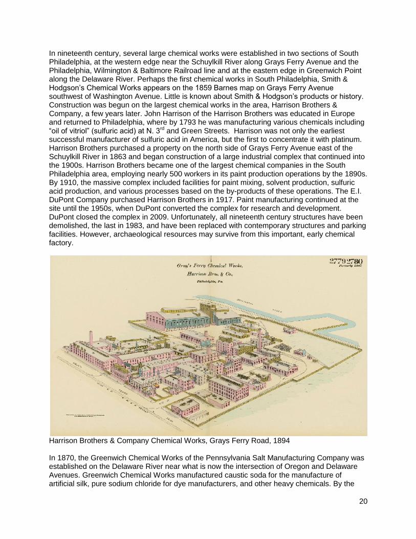
In nineteenth century, several large chemical works were established in two sections of South Philadelphia, at the western edge near the Schuylkill River along Grays Ferry Avenue and the Philadelphia, Wilmington & Baltimore Railroad line and at the eastern edge in Greenwich Point along the Delaware River. Perhaps the first chemical works in South Philadelphia, Smith & Hodgson’s Chemical Works appears on the 1859 Barnes map on Grays Ferry Avenue southwest of Washington Avenue. Little is known about Smith & Hodgson’s products or history. Construction was begun on the largest chemical works in the area, Harrison Brothers & Company, a few years later. John Harrison of the Harrison Brothers was educated in Europe and returned to Philadelphia, where by 1793 he was manufacturing various chemicals including “oil of vitriol” (sulfuric acid) at N. 3rd and Green Streets. Harrison was not only the earliest successful manufacturer of sulfuric acid in America, but the first to concentrate it with platinum. Harrison Brothers purchased a property on the north side of Grays Ferry Avenue east of the Schuylkill River in 1863 and began construction of a large industrial complex that continued into the 1900s. Harrison Brothers became one of the largest chemical companies in the South Philadelphia area, employing nearly 500 workers in its paint production operations by the 1890s. By 1910, the massive complex included facilities for paint mixing, solvent production, sulfuric acid production, and various processes based on the by-products of these operations. The E.I. DuPont Company purchased Harrison Brothers in 1917. Paint manufacturing continued at the site until the 1950s, when DuPont converted the complex for research and development. DuPont closed the complex in 2009. Unfortunately, all nineteenth century structures have been demolished, the last in 1983, and have been replaced with contemporary structures and parking facilities. However, archaeological resources may survive from this important, early chemical factory.
Harrison Brothers & Company Chemical Works, Grays Ferry Road, 1894 In 1870, the Greenwich Chemical Works of the Pennsylvania Salt Manufacturing Company was established on the Delaware River near what is now the intersection of Oregon and Delaware Avenues. Greenwich Chemical Works manufactured caustic soda for the manufacture of artificial silk, pure sodium chloride for dye manufacturers, and other heavy chemicals. By the
21
1890s, it had grown into a huge complex of more than 30 buildings in which 400 men labored. Delaware River Chemical Works, owned by Baugh & Sons, at the eastern end of Morris Street, was established in 1872 and, by 1892, included 42 buildings in which 300 to 500 men and boys worked. Delaware River Chemical Works produced glue, grease, ground bone, Neat’s Foot oil, bone black, and other chemical products. Big-box stores now occupy the sites of both the Greenwich Chemical Works and Delaware River Chemical Works. It is unlikely that any above-grade historic resources survive from either complex.
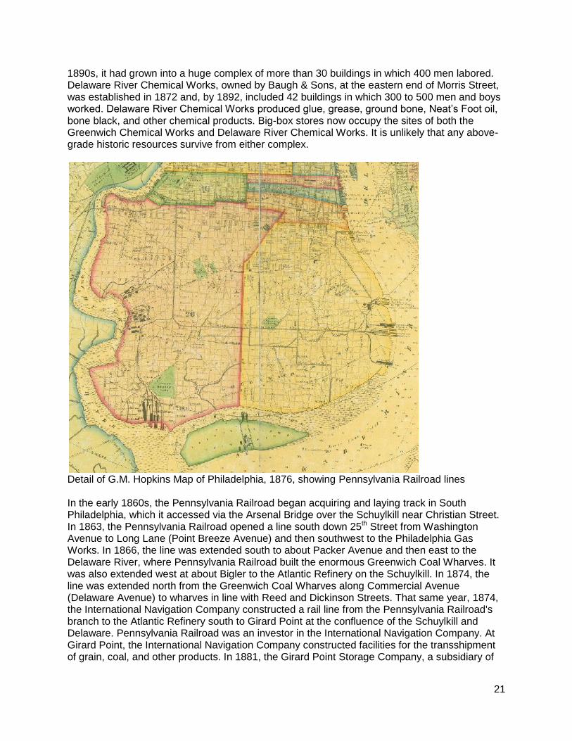
Detail of G.M. Hopkins Map of Philadelphia, 1876, showing Pennsylvania Railroad lines In the early 1860s, the Pennsylvania Railroad began acquiring and laying track in South Philadelphia, which it accessed via the Arsenal Bridge over the Schuylkill near Christian Street. In 1863, the Pennsylvania Railroad opened a line south down 25th Street from Washington Avenue to Long Lane (Point Breeze Avenue) and then southwest to the Philadelphia Gas Works. In 1866, the line was extended south to about Packer Avenue and then east to the Delaware River, where Pennsylvania Railroad built the enormous Greenwich Coal Wharves. It was also extended west at about Bigler to the Atlantic Refinery on the Schuylkill. In 1874, the line was extended north from the Greenwich Coal Wharves along Commercial Avenue (Delaware Avenue) to wharves in line with Reed and Dickinson Streets. That same year, 1874, the International Navigation Company constructed a rail line from the Pennsylvania Railroad's branch to the Atlantic Refinery south to Girard Point at the confluence of the Schuylkill and Delaware. Pennsylvania Railroad was an investor in the International Navigation Company. At Girard Point, the International Navigation Company constructed facilities for the transshipment of grain, coal, and other products. In 1881, the Girard Point Storage Company, a subsidiary of
22
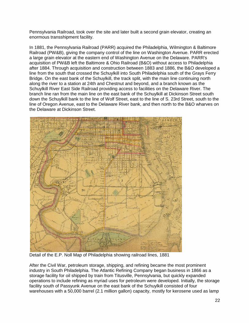
Pennsylvania Railroad, took over the site and later built a second grain elevator, creating an enormous transshipment facility. In 1881, the Pennsylvania Railroad (PARR) acquired the Philadelphia, Wilmington & Baltimore Railroad (PW&B), giving the company control of the line on Washington Avenue. PARR erected a large grain elevator at the eastern end of Washington Avenue on the Delaware. PARR's acquisition of PW&B left the Baltimore & Ohio Railroad (B&O) without access to Philadelphia after 1884. Through acquisition and construction between 1883 and 1886, the B&O developed a line from the south that crossed the Schuylkill into South Philadelphia south of the Grays Ferry Bridge. On the east bank of the Schuylkill, the track split, with the main line continuing north along the river to a station at 24th and Chestnut and beyond, and a branch known as the Schuylkill River East Side Railroad providing access to facilities on the Delaware River. The branch line ran from the main line on the east bank of the Schuylkill at Dickinson Street south down the Schuylkill bank to the line of Wolf Street, east to the line of S. 23rd Street, south to the line of Oregon Avenue, east to the Delaware River bank, and then north to the B&O wharves on the Delaware at Dickinson Street.
Detail of the E.P. Noll Map of Philadelphia showing railroad lines, 1881 After the Civil War, petroleum storage, shipping, and refining became the most prominent industry in South Philadelphia. The Atlantic Refining Company began business in 1866 as a storage facility for oil shipped by train from Titusville, Pennsylvania, but quickly expanded operations to include refining as myriad uses for petroleum were developed. Initially, the storage facility south of Passyunk Avenue on the east bank of the Schuylkill consisted of four warehouses with a 50,000 barrel (2.1 million gallon) capacity, mostly for kerosene used as lamp

23
oil. In 1874, John D. Rockefeller took over the company and integrated it into Standard Oil Trust. Under Rockefeller, the company grew quickly, becoming Philadelphia's largest employer. By 1882, Atlantic Refining's plant at Point Breeze was one of the largest refineries in the United States; it employed 2,950 workers and produced 90 million gallons of refined oil during that year. In 1891, Philadelphia was exporting 35% of all U.S. petroleum and the Atlantic Refinery was producing nearly 50% of the world's illuminating fuel. The refinery continued to grow, eventually expanding north of Passyunk Avenue and the Gas Works and also opening a facility at Point Breeze Avenue and 25th Street. In 1911, the US Supreme Court invoked the Sherman Antitrust Act and ordered the dismantling of Standard Oil Trust, resulting in the reestablishment of Atlantic as an independent company. By 1915, the Point Breeze refinery was manufacturing gasoline for automobiles sold at gas stations with pumps. In 1918, the Point Breeze refinery produced “Fighting Red,” a superior-grade aviation fuel for the US Air Force in World War I. By World War II, the Atlantic refinery and the Gulf Oil refinery on the west bank of the Schuylkill were together processing 69,000 barrels a day (2.9 million gallons). In 1966, Atlantic merged with Richfield Oil to create ARCO. In 1985, ARCO sold off its interests in the northeast to oil trader John Deuss, who resumed the use of the Atlantic name. In 1988, Atlantic was purchased by Sunoco, which combined the two refineries facing one another across the Schuylkill. In 2012, Sunoco entered a joint venture with the Carlyle Group LP to run the merged refining facilities on the Schuylkill as Philadelphia Energy Solutions. The Atlantic refinery is the longest continuously operating oil facility in the U.S. and possibly in the world and, with the former Gulf refinery, is the largest oil refining complex on the U.S. Eastern seaboard. Although inaccessible to the public, the massive and extremely historically significant industrial complex should be surveyed to determine whether any historic resources survive at the constantly evolving site.
Atlantic Petroleum Storage Company on the east bank of the Schuylkill River, 1866
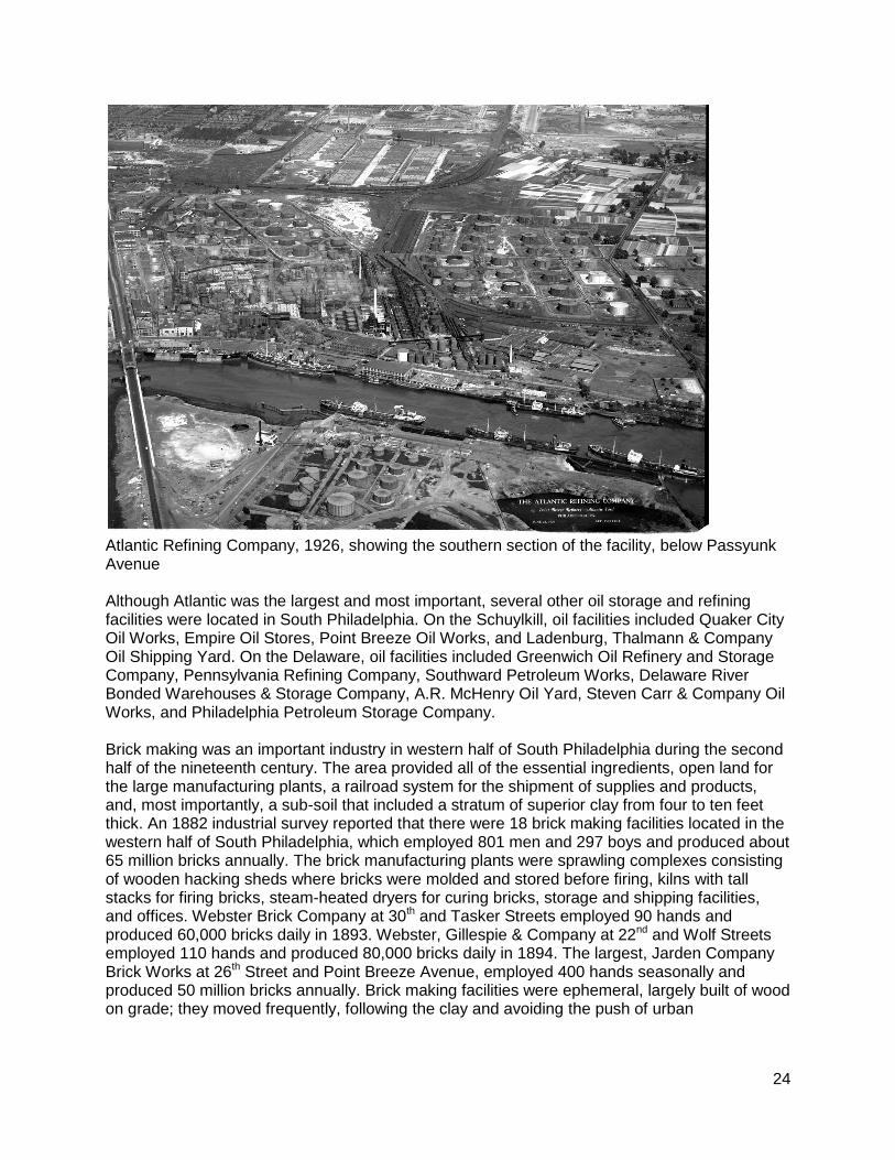
24
Atlantic Refining Company, 1926, showing the southern section of the facility, below Passyunk Avenue Although Atlantic was the largest and most important, several other oil storage and refining facilities were located in South Philadelphia. On the Schuylkill, oil facilities included Quaker City Oil Works, Empire Oil Stores, Point Breeze Oil Works, and Ladenburg, Thalmann & Company Oil Shipping Yard. On the Delaware, oil facilities included Greenwich Oil Refinery and Storage Company, Pennsylvania Refining Company, Southward Petroleum Works, Delaware River Bonded Warehouses & Storage Company, A.R. McHenry Oil Yard, Steven Carr & Company Oil Works, and Philadelphia Petroleum Storage Company. Brick making was an important industry in western half of South Philadelphia during the second half of the nineteenth century. The area provided all of the essential ingredients, open land for the large manufacturing plants, a railroad system for the shipment of supplies and products, and, most importantly, a sub-soil that included a stratum of superior clay from four to ten feet thick. An 1882 industrial survey reported that there were 18 brick making facilities located in the western half of South Philadelphia, which employed 801 men and 297 boys and produced about 65 million bricks annually. The brick manufacturing plants were sprawling complexes consisting of wooden hacking sheds where bricks were molded and stored before firing, kilns with tall stacks for firing bricks, steam-heated dryers for curing bricks, storage and shipping facilities, and offices. Webster Brick Company at 30th and Tasker Streets employed 90 hands and produced 60,000 bricks daily in 1893. Webster, Gillespie & Company at 22nd and Wolf Streets employed 110 hands and produced 80,000 bricks daily in 1894. The largest, Jarden Company Brick Works at 26th Street and Point Breeze Avenue, employed 400 hands seasonally and produced 50 million bricks annually. Brick making facilities were ephemeral, largely built of wood on grade; they moved frequently, following the clay and avoiding the push of urban
25
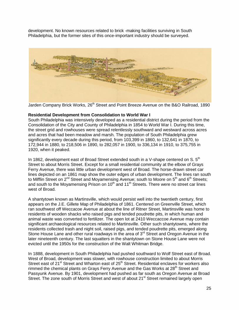
development. No known resources related to brick -making facilities surviving in South Philadelphia, but the former sites of this once-important industry should be surveyed.
Jarden Company Brick Works, 26th Street and Point Breeze Avenue on the B&O Railroad, 1890 Residential Development from Consolidation to World War I South Philadelphia was intensively developed as a residential district during the period from the Consolidation of the City and County of Philadelphia in 1854 to World War I. During this time, the street grid and rowhouses were spread relentlessly southward and westward across acres and acres that had been meadow and marsh. The population of South Philadelphia grew significantly every decade during this period, from 103,399 in 1860, to 132,641 in 1870, to 172,944 in 1880, to 218,506 in 1890, to 282,057 in 1900, to 336,134 in 1910, to 375,755 in 1920, when it peaked. In 1862, development east of Broad Street extended south in a V-shape centered on S. 5th Street to about Morris Street. Except for a small residential community at the elbow of Grays Ferry Avenue, there was little urban development west of Broad. The horse-drawn street car lines depicted on an 1861 map show the outer edges of urban development. The lines ran south to Mifflin Street on 2nd Street and Moyamensing Avenue; south to Moore on 5th and 6th Streets; and south to the Moyamensing Prison on 10th and 11th Streets. There were no street car lines west of Broad. A shantytown known as Martinsville, which would persist well into the twentieth century, first appears on the J.E. Gillete Map of Philadelphia of 1861. Centered on Greenville Street, which ran southwest off Weccacoe Avenue at about the line of Ritner Street, Martinsville was home to residents of wooden shacks who raised pigs and tended poudrette pits, in which human and animal waste was converted to fertilizer. The open lot at 2410 Weccaccoe Avenue may contain significant archaeological resources related to Martinsville. Other such shantytowns, where the residents collected trash and night soil, raised pigs, and tended poudrette pits, emerged along Stone House Lane and other rural roadways in the area of 3rd Street and Oregon Avenue in the later nineteenth century. The last squatters in the shantytown on Stone House Lane were not evicted until the 1950s for the construction of the Walt Whitman Bridge. In 1888, development in South Philadelphia had pushed southward to Wolf Street east of Broad. West of Broad, development was slower, with rowhouse construction limited to about Morris Street east of 21st Street and Wharton east of 25th Street. Residential enclaves for workers also rimmed the chemical plants on Grays Ferry Avenue and the Gas Works at 28th Street and Passyunk Avenue. By 1901, development had pushed as far south as Oregon Avenue at Broad Street. The zone south of Morris Street and west of about 21st Street remained largely open
26
land. By 1910, South Philadelphia had been nearly built out to the boundaries created by the at-grade rail lines on 25th Street and Oregon Avenue. South Philadelphia was a melting pot where Irish, German, African Americans, Italians, Jews, Eastern Europeans, and others settled in ethnic and racial enclaves in the nineteenth and early twentieth centuries. Numerous sites within South Philadelphia are associated with various communities that called this neighborhood home. Before the imposition of the street grid, Irish Lane ran southwest from South Street west of Broad into the open lands of South Philadelphia. Numerous resources representing the German presence in South Philadelphia survive including the former Third German Baptist Church at 612 Dickinson Street and the former St. John’s German Evangelical Lutheran Church at 516 Wharton Street. Unfortunately, Schanbacher’s Halle at 1715 S. 4th Street was recently demolished. Alain Leroy Locke, the first African American Rhodes Scholar and the so-called “Dean” of the Harlem Renaissance, was born in 1885 at 2221 S. 5th Street. Home to the Italian Market and St. Mary Magdalen de Pazzi Church at 710-720 Montrose Street, the first Italian national parish in the United States, South Philadelphia has long been associated with Italian Americans. The 1910 Census indicates that there were more Jews than other foreign-born immigrant group in South Philadelphia. The former Jewish Education Center #2 at 2501-15 S. Marshall Street, which is listed on the Philadelphia Register, is just one of many Jewish landmarks in the neighborhood. A Lithuanian community surrounded St. Casimir’s Church and School on the 300-block of Wharton Street. A Russian community surrounded the Assumption of the Holy Virgin Russian Orthodox Church, at 2101A S. 28th Street, in the southwest corner of South Philadelphia. People from the Carpathian Mountains of the Austro-Hungarian Empire, which became Czechoslovakia, founded the Holy Ghost Byzantine Catholic Church on Passyunk Avenue in 1891. In 1923, they built a new church at 2310 S. 24th Street. Since the waves of immigration in the late nineteenth and early twentieth centuries, many have left South Philadelphia for the suburbs, making way for newcomers from the rural South, Central America, Southeast Asia, and elsewhere. Numerous potentially significant historic resources represent the residential development of South Philadelphia in the second half of the nineteenth century and early twentieth century. An overview of potential designations follows according to building type. The stretch of South Broad Street running through the South District showcases many grand row houses, which have great significance in Philadelphia’s architectural and social histories. Constructed from the 1880s through the early 1900s by the era’s most prominent architects, these elegant homes of brick and brownstone with elaborate bays and ornamentation constitute an encyclopedia of Late Victorian styles. The residences of prominent newspaper publishers, lawyers, doctors, politicians, industrialists, and clergy, the houses also represent the elite of South Philadelphia’s Scotch-Irish community, which was centered on the Scots Presbyterian Church at Broad and Castle, built in 1887 and demolished in 1955. The following residential buildings on South Broad Street could be considered significant within a South Broad Street residential thematic district:
1100 Block: 1145, 1147, 1164 (David Garrison house/St. Rita’s parish house, circa 1883 by Willis Hale)
1200 Block: 1207, 1209, 1211, 1213, 1215 (circa 1889), 1216, 1218, 1220 (circa 1888), 1232 (circa 1886)
1300 Block: 1308 (circa 1901 by Werner Trumbauer), 1316, 1325 (circa 1880)
1400 Block: entire east side (circa 1880); 1432 (circa 1897 by William McCauley), 1434
1500 Block: 1518-20 (circa 1888 by Charles Callom)
27
1600 Block: 1609, 1611, 1613, 1615, 1606, 1608, 1610 (circa 1891), 1640, 1642, 1645 (circa 1891)
1800 Block: 1814-1828 west side; 1809-1831, 1841, 1843 (circa 1893) east side
1900 Block: 1919, 1921, 1923
2200 Block: 2202, 2206, 2208, 2210, 2221 (circa 1889)
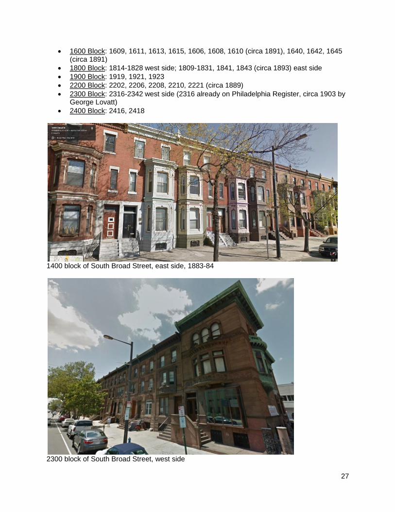
2300 Block: 2316-2342 west side (2316 already on Philadelphia Register, circa 1903 by George Lovatt)
2400 Block: 2416, 2418
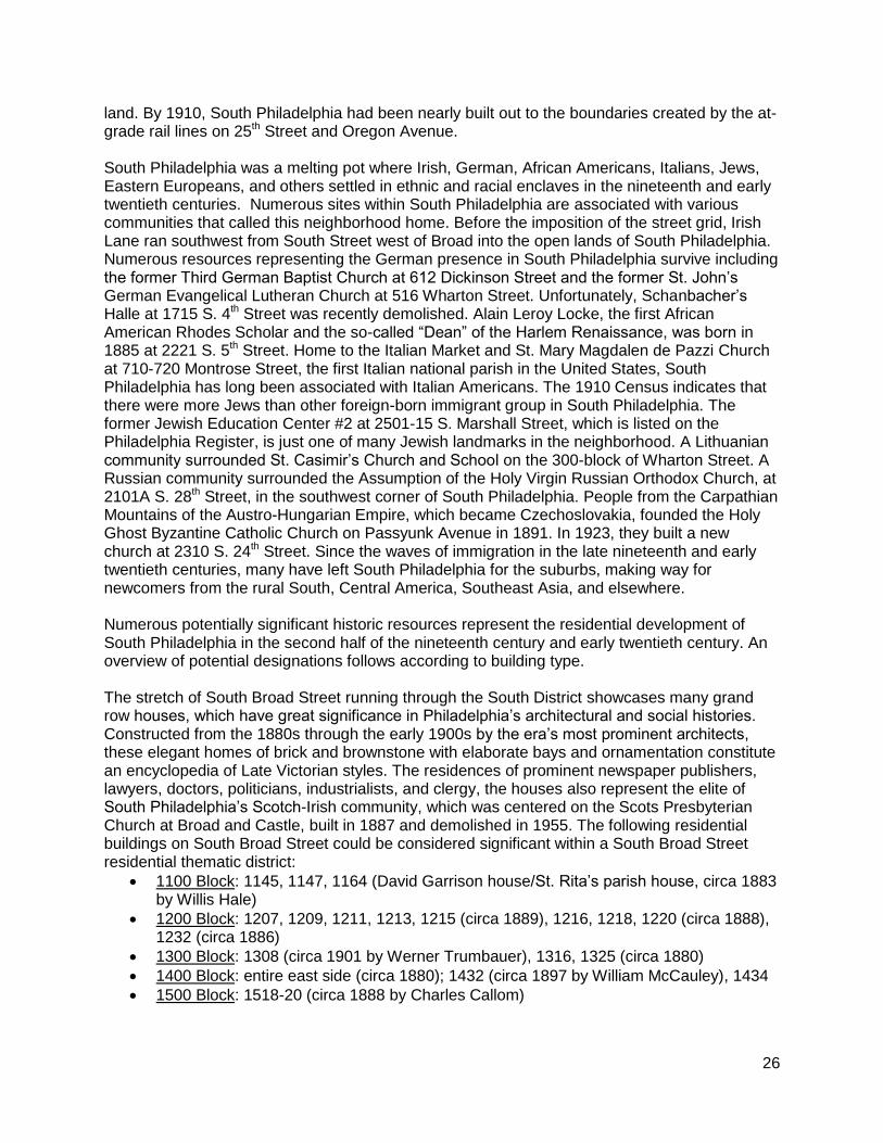
1400 block of South Broad Street, east side, 1883-84
2300 block of South Broad Street, west side
28
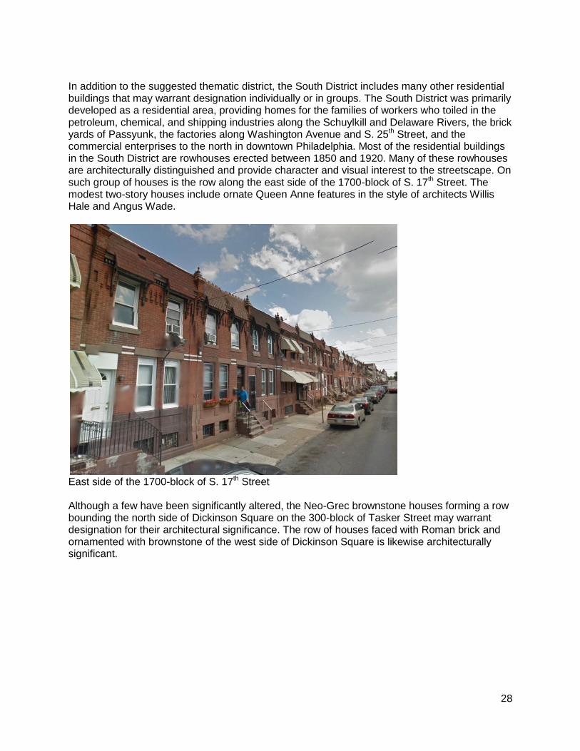
In addition to the suggested thematic district, the South District includes many other residential buildings that may warrant designation individually or in groups. The South District was primarily developed as a residential area, providing homes for the families of workers who toiled in the petroleum, chemical, and shipping industries along the Schuylkill and Delaware Rivers, the brick yards of Passyunk, the factories along Washington Avenue and S. 25th Street, and the commercial enterprises to the north in downtown Philadelphia. Most of the residential buildings in the South District are rowhouses erected between 1850 and 1920. Many of these rowhouses are architecturally distinguished and provide character and visual interest to the streetscape. On such group of houses is the row along the east side of the 1700-block of S. 17th Street. The modest two-story houses include ornate Queen Anne features in the style of architects Willis Hale and Angus Wade.
East side of the 1700-block of S. 17th Street Although a few have been significantly altered, the Neo-Grec brownstone houses forming a row bounding the north side of Dickinson Square on the 300-block of Tasker Street may warrant designation for their architectural significance. The row of houses faced with Roman brick and ornamented with brownstone of the west side of Dickinson Square is likewise architecturally significant.

29
North side of the 300-block of Tasker Street In 1885, Alain Leroy Locke, the first African American Rhodes Scholar and the so-called “Dean” of the Harlem Renaissance, was born at 2221 S. 5th Street. His book, The New Negro, a collection of writings by African Americans published in 1925, is considered a landmark in literature.
Alain Leroy Locke House, 2221 S. 5th Street
30
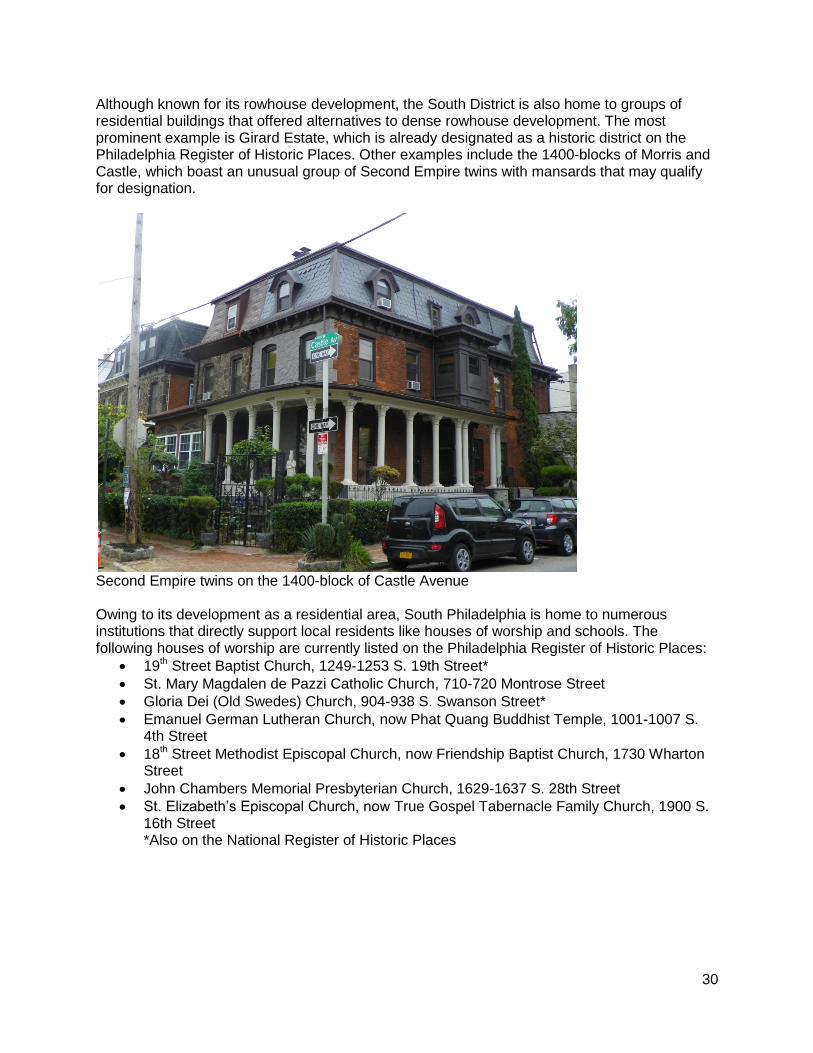
Although known for its rowhouse development, the South District is also home to groups of residential buildings that offered alternatives to dense rowhouse development. The most prominent example is Girard Estate, which is already designated as a historic district on the Philadelphia Register of Historic Places. Other examples include the 1400-blocks of Morris and Castle, which boast an unusual group of Second Empire twins with mansards that may qualify for designation.
Second Empire twins on the 1400-block of Castle Avenue Owing to its development as a residential area, South Philadelphia is home to numerous institutions that directly support local residents like houses of worship and schools. The following houses of worship are currently listed on the Philadelphia Register of Historic Places:
19th Street Baptist Church, 1249-1253 S. 19th Street*
St. Mary Magdalen de Pazzi Catholic Church, 710-720 Montrose Street
Gloria Dei (Old Swedes) Church, 904-938 S. Swanson Street*
Emanuel German Lutheran Church, now Phat Quang Buddhist Temple, 1001-1007 S. 4th Street
18th Street Methodist Episcopal Church, now Friendship Baptist Church, 1730 Wharton Street
John Chambers Memorial Presbyterian Church, 1629-1637 S. 28th Street
St. Elizabeth’s Episcopal Church, now True Gospel Tabernacle Family Church, 1900 S. 16th Street *Also on the National Register of Historic Places
31
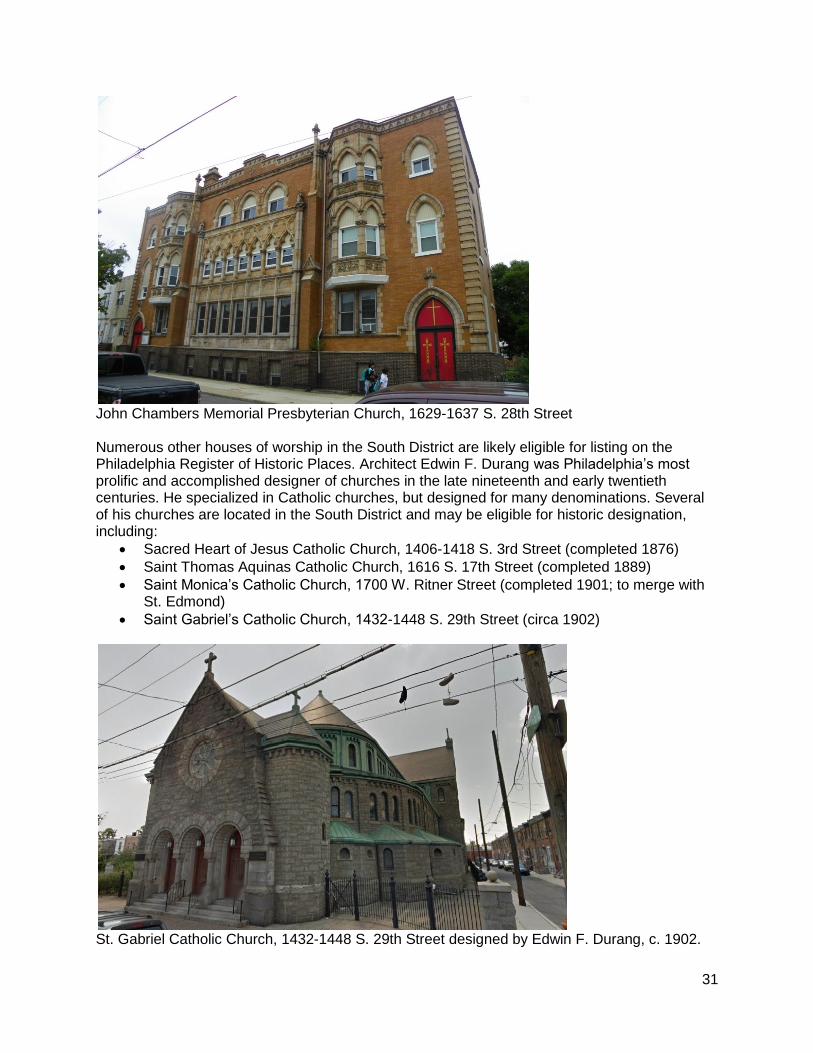
John Chambers Memorial Presbyterian Church, 1629-1637 S. 28th Street Numerous other houses of worship in the South District are likely eligible for listing on the Philadelphia Register of Historic Places. Architect Edwin F. Durang was Philadelphia’s most prolific and accomplished designer of churches in the late nineteenth and early twentieth centuries. He specialized in Catholic churches, but designed for many denominations. Several of his churches are located in the South District and may be eligible for historic designation, including:
Sacred Heart of Jesus Catholic Church, 1406-1418 S. 3rd Street (completed 1876)
Saint Thomas Aquinas Catholic Church, 1616 S. 17th Street (completed 1889)
Saint Monica’s Catholic Church, 1700 W. Ritner Street (completed 1901; to merge with St. Edmond)
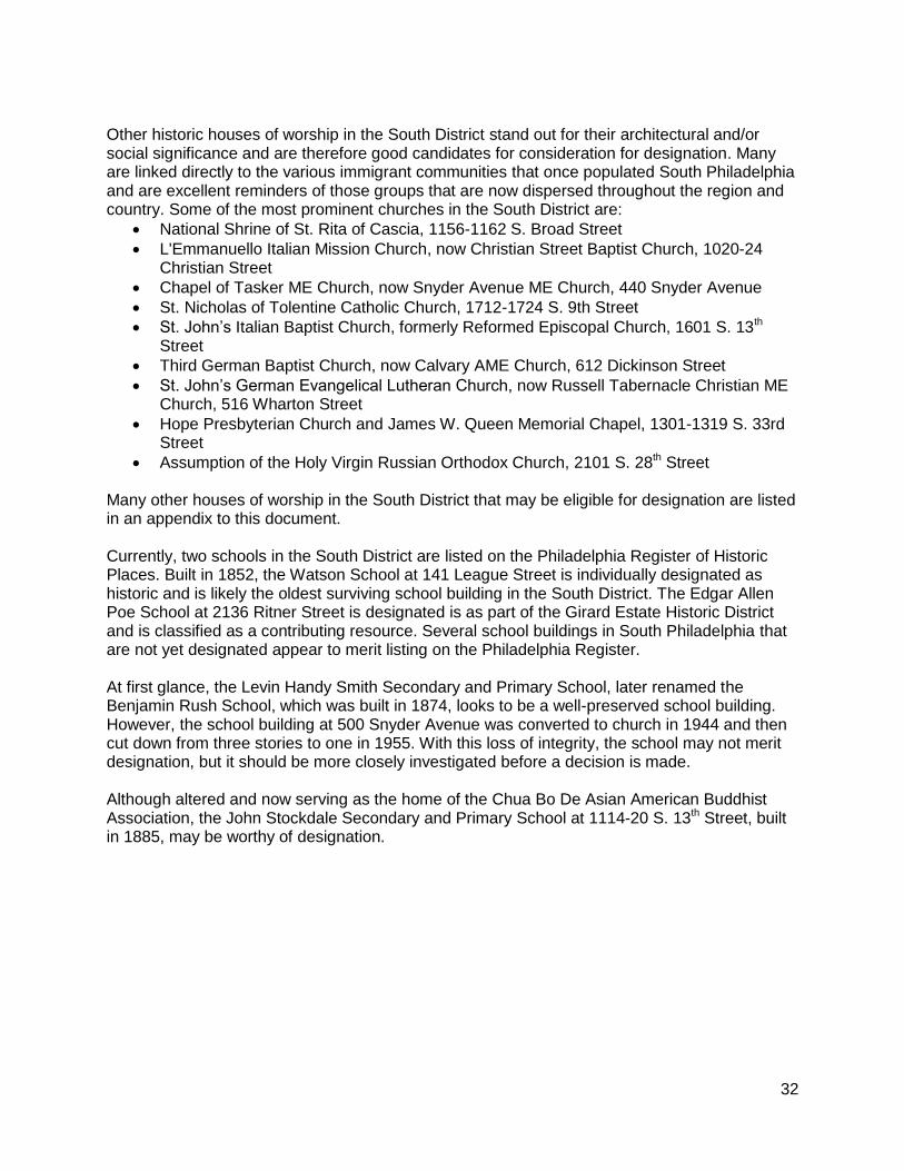
Saint Gabriel’s Catholic Church, 1432-1448 S. 29th Street (circa 1902)
St. Gabriel Catholic Church, 1432-1448 S. 29th Street designed by Edwin F. Durang, c. 1902.
32
Other historic houses of worship in the South District stand out for their architectural and/or social significance and are therefore good candidates for consideration for designation. Many are linked directly to the various immigrant communities that once populated South Philadelphia and are excellent reminders of those groups that are now dispersed throughout the region and country. Some of the most prominent churches in the South District are:
National Shrine of St. Rita of Cascia, 1156-1162 S. Broad Street
L'Emmanuello Italian Mission Church, now Christian Street Baptist Church, 1020-24 Christian Street
Chapel of Tasker ME Church, now Snyder Avenue ME Church, 440 Snyder Avenue
St. Nicholas of Tolentine Catholic Church, 1712-1724 S. 9th Street
St. John’s Italian Baptist Church, formerly Reformed Episcopal Church, 1601 S. 13th Street
Third German Baptist Church, now Calvary AME Church, 612 Dickinson Street
St. John’s German Evangelical Lutheran Church, now Russell Tabernacle Christian ME Church, 516 Wharton Street
Hope Presbyterian Church and James W. Queen Memorial Chapel, 1301-1319 S. 33rd Street
Assumption of the Holy Virgin Russian Orthodox Church, 2101 S. 28th Street
Many other houses of worship in the South District that may be eligible for designation are listed in an appendix to this document. Currently, two schools in the South District are listed on the Philadelphia Register of Historic Places. Built in 1852, the Watson School at 141 League Street is individually designated as historic and is likely the oldest surviving school building in the South District. The Edgar Allen Poe School at 2136 Ritner Street is designated is as part of the Girard Estate Historic District and is classified as a contributing resource. Several school buildings in South Philadelphia that are not yet designated appear to merit listing on the Philadelphia Register. At first glance, the Levin Handy Smith Secondary and Primary School, later renamed the Benjamin Rush School, which was built in 1874, looks to be a well-preserved school building. However, the school building at 500 Snyder Avenue was converted to church in 1944 and then cut down from three stories to one in 1955. With this loss of integrity, the school may not merit designation, but it should be more closely investigated before a decision is made. Although altered and now serving as the home of the Chua Bo De Asian American Buddhist Association, the John Stockdale Secondary and Primary School at 1114-20 S. 13th Street, built in 1885, may be worthy of designation.
33
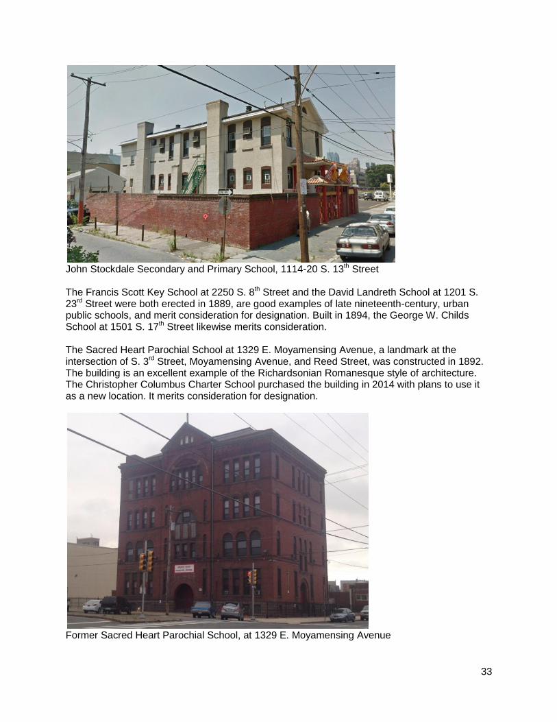
John Stockdale Secondary and Primary School, 1114-20 S. 13th Street The Francis Scott Key School at 2250 S. 8th Street and the David Landreth School at 1201 S. 23rd Street were both erected in 1889, are good examples of late nineteenth-century, urban public schools, and merit consideration for designation. Built in 1894, the George W. Childs School at 1501 S. 17th Street likewise merits consideration. The Sacred Heart Parochial School at 1329 E. Moyamensing Avenue, a landmark at the intersection of S. 3rd Street, Moyamensing Avenue, and Reed Street, was constructed in 1892. The building is an excellent example of the Richardsonian Romanesque style of architecture. The Christopher Columbus Charter School purchased the building in 2014 with plans to use it as a new location. It merits consideration for designation.
Former Sacred Heart Parochial School, at 1329 E. Moyamensing Avenue
34
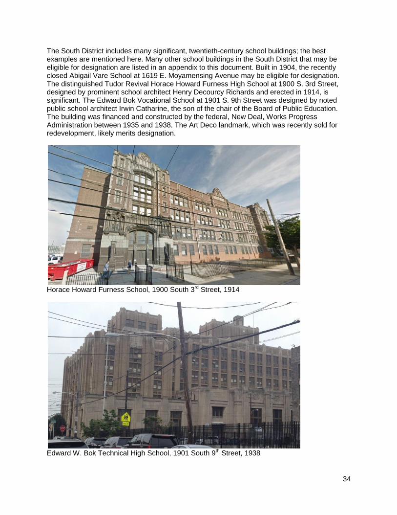
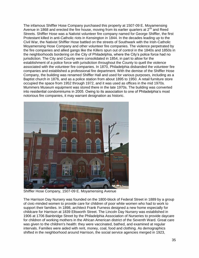
The South District includes many significant, twentieth-century school buildings; the best examples are mentioned here. Many other school buildings in the South District that may be eligible for designation are listed in an appendix to this document. Built in 1904, the recently closed Abigail Vare School at 1619 E. Moyamensing Avenue may be eligible for designation. The distinguished Tudor Revival Horace Howard Furness High School at 1900 S. 3rd Street, designed by prominent school architect Henry Decourcy Richards and erected in 1914, is significant. The Edward Bok Vocational School at 1901 S. 9th Street was designed by noted public school architect Irwin Catharine, the son of the chair of the Board of Public Education. The building was financed and constructed by the federal, New Deal, Works Progress Administration between 1935 and 1938. The Art Deco landmark, which was recently sold for redevelopment, likely merits designation.
Horace Howard Furness School, 1900 South 3rd Street, 1914
Edward W. Bok Technical High School, 1901 South 9th Street, 1938
35
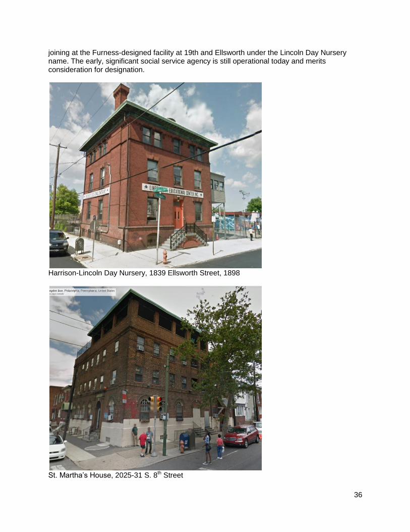
The infamous Shiffler Hose Company purchased this property at 1507-09 E. Moyamensing Avenue in 1868 and erected the fire house, moving from its earlier quarters at 2nd and Reed Streets. Shiffler Hose was a Nativist volunteer fire company named for George Shiffler, the first Protestant killed in anti-Catholic riots in Kensington in 1844. In the decades leading up to the Civil War, the Nativist Shiffler Hose battled on the streets of Southwark with the Irish-Catholic Moyamensing Hose Company and other volunteer fire companies. The violence perpetrated by the fire companies and allied gangs like the Killers spun out of control in the 1840s and 1850s in the neighborhoods bordering on the City of Philadelphia, where the City’s police force had no jurisdiction. The City and County were consolidated in 1854, in part to allow for the establishment of a police force with jurisdiction throughout the County to quell the violence associated with the volunteer fire companies. In 1870, Philadelphia disbanded the volunteer fire companies and established a professional fire department. With the demise of the Shiffler Hose Company, the building was renamed Shiffler Hall and used for various purposes, including as a Baptist church in 1876, and as a police station from about 1895 to 1950. A retail furniture store occupied the space from 1952 through 1972, and it was used as offices in the mid 1970s. Mummers Museum equipment was stored there in the late 1970s. The building was converted into residential condominiums in 2005. Owing to its association to one of Philadelphia’s most notorious fire companies, it may warrant designation as historic.
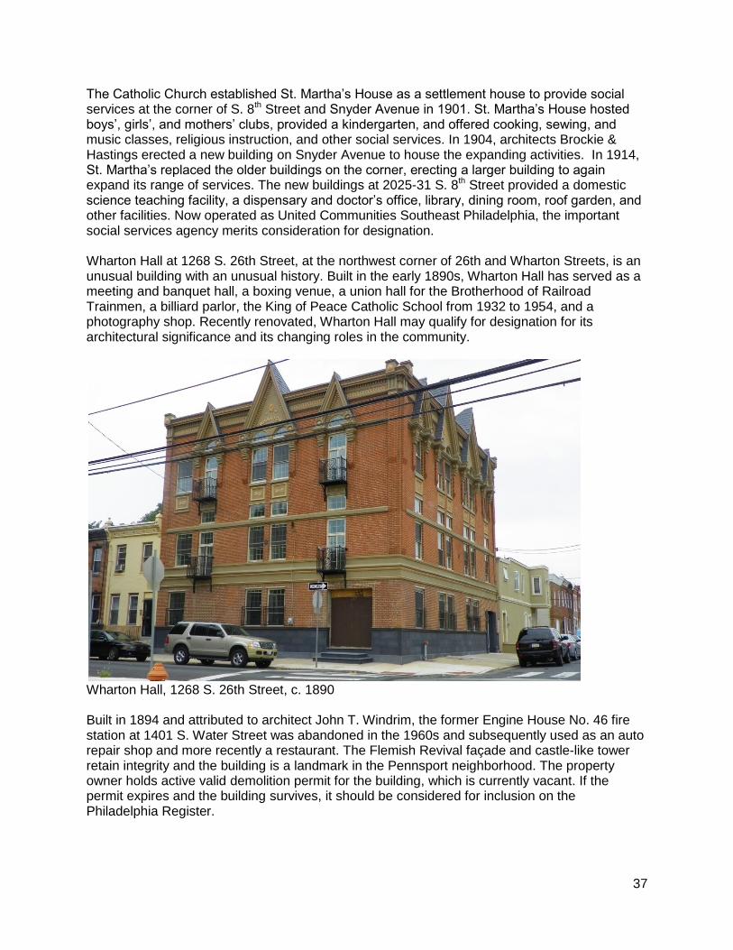
Shiffler Hose Company, 1507-09 E. Moyamensing Avenue The Harrison Day Nursery was founded on the 1800-block of Federal Street in 1889 by a group of civic-minded women to provide care for children of poor white women who had to work to support their families. In 1898, architect Frank Furness designed a new home especially for childcare for Harrison at 1839 Ellsworth Street. The Lincoln Day Nursery was established in 1906 at 1706 Bainbridge Street by the Philadelphia Association of Nurseries to provide daycare for children of working mothers in the African American district of the Seventh Ward. Great care was given to the children's health: they were vaccinated, bathed, and examined at regular intervals. Families were aided with rent, money, coal, food and clothing. As demographics shifted in the neighborhood around Harrison, the social service agencies merged in 1923,
36
joining at the Furness-designed facility at 19th and Ellsworth under the Lincoln Day Nursery name. The early, significant social service agency is still operational today and merits consideration for designation.
Harrison-Lincoln Day Nursery, 1839 Ellsworth Street, 1898
St. Martha’s House, 2025-31 S. 8th Street
37
The Catholic Church established St. Martha’s House as a settlement house to provide social services at the corner of S. 8th Street and Snyder Avenue in 1901. St. Martha’s House hosted boys’, girls’, and mothers’ clubs, provided a kindergarten, and offered cooking, sewing, and music classes, religious instruction, and other social services. In 1904, architects Brockie & Hastings erected a new building on Snyder Avenue to house the expanding activities. In 1914, St. Martha’s replaced the older buildings on the corner, erecting a larger building to again expand its range of services. The new buildings at 2025-31 S. 8th Street provided a domestic science teaching facility, a dispensary and doctor’s office, library, dining room, roof garden, and other facilities. Now operated as United Communities Southeast Philadelphia, the important social services agency merits consideration for designation. Wharton Hall at 1268 S. 26th Street, at the northwest corner of 26th and Wharton Streets, is an unusual building with an unusual history. Built in the early 1890s, Wharton Hall has served as a meeting and banquet hall, a boxing venue, a union hall for the Brotherhood of Railroad Trainmen, a billiard parlor, the King of Peace Catholic School from 1932 to 1954, and a photography shop. Recently renovated, Wharton Hall may qualify for designation for its architectural significance and its changing roles in the community.
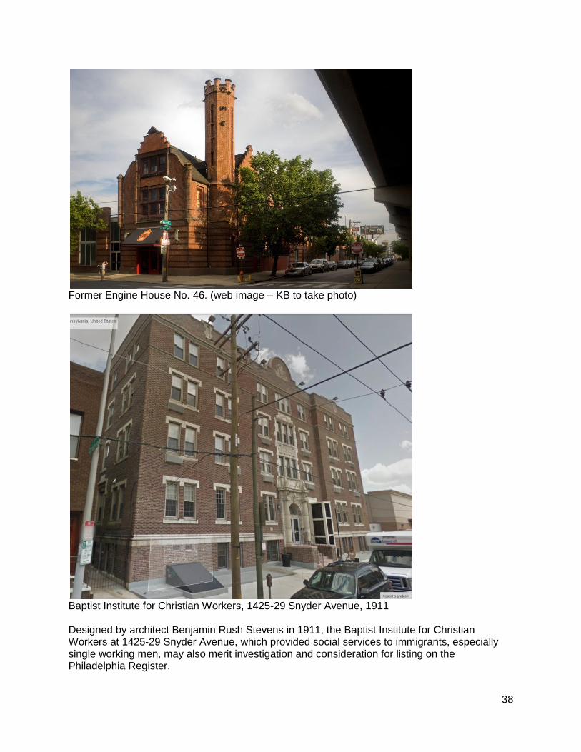
Wharton Hall, 1268 S. 26th Street, c. 1890 Built in 1894 and attributed to architect John T. Windrim, the former Engine House No. 46 fire station at 1401 S. Water Street was abandoned in the 1960s and subsequently used as an auto repair shop and more recently a restaurant. The Flemish Revival façade and castle-like tower retain integrity and the building is a landmark in the Pennsport neighborhood. The property owner holds active valid demolition permit for the building, which is currently vacant. If the permit expires and the building survives, it should be considered for inclusion on the Philadelphia Register.
38
Former Engine House No. 46. (web image – KB to take photo)
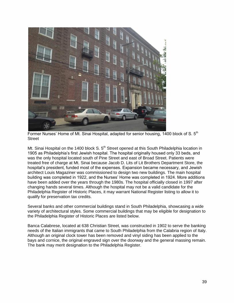
Baptist Institute for Christian Workers, 1425-29 Snyder Avenue, 1911 Designed by architect Benjamin Rush Stevens in 1911, the Baptist Institute for Christian Workers at 1425-29 Snyder Avenue, which provided social services to immigrants, especially single working men, may also merit investigation and consideration for listing on the Philadelphia Register.
39
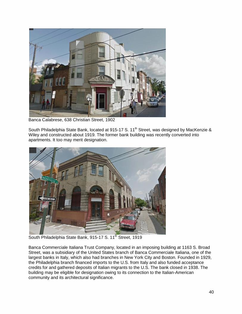
Former Nurses’ Home of Mt. Sinai Hospital, adapted for senior housing, 1400 block of S. 5th Street Mt. Sinai Hospital on the 1400 block S. 5th Street opened at this South Philadelphia location in 1905 as Philadelphia’s first Jewish hospital. The hospital originally housed only 33 beds, and was the only hospital located south of Pine Street and east of Broad Street. Patients were treated free of charge at Mt. Sinai because Jacob D. Lits of Lit Brothers Department Store, the hospital’s president, funded most of the expenses. Expansion became necessary, and Jewish architect Louis Magaziner was commissioned to design two new buildings. The main hospital building was completed in 1922, and the Nurses’ Home was completed in 1924. More additions have been added over the years through the 1980s. The hospital officially closed in 1997 after changing hands several times. Although the hospital may not be a valid candidate for the Philadelphia Register of Historic Places, it may warrant National Register listing to allow it to qualify for preservation tax credits. Several banks and other commercial buildings stand in South Philadelphia, showcasing a wide variety of architectural styles. Some commercial buildings that may be eligible for designation to the Philadelphia Register of Historic Places are listed below. Banca Calabrese, located at 638 Christian Street, was constructed in 1902 to serve the banking needs of the Italian immigrants that came to South Philadelphia from the Calabria region of Italy. Although an original clock tower has been removed and vinyl siding has been applied to the bays and cornice, the original engraved sign over the doorway and the general massing remain. The bank may merit designation to the Philadelphia Register.
40
Banca Calabrese, 638 Christian Street, 1902 South Philadelphia State Bank, located at 915-17 S. 11th Street, was designed by MacKenzie & Wiley and constructed about 1919. The former bank building was recently converted into apartments. It too may merit designation.
South Philadelphia State Bank, 915-17 S. 11th Street, 1919 Banca Commerciale Italiana Trust Company, located in an imposing building at 1163 S. Broad Street, was a subsidiary of the United States branch of Banca Commerciale Italiana, one of the largest banks in Italy, which also had branches in New York City and Boston. Founded in 1929, the Philadelphia branch financed imports to the U.S. from Italy and also funded acceptance credits for and gathered deposits of Italian migrants to the U.S. The bank closed in 1938. The building may be eligible for designation owing to its connection to the Italian-American community and its architectural significance.
41
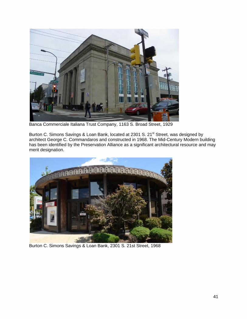
Banca Commerciale Italiana Trust Company, 1163 S. Broad Street, 1929 Burton C. Simons Savings & Loan Bank, located at 2301 S. 21st Street, was designed by architect George C. Commandaros and constructed in 1968. The Mid-Century Modern building has been identified by the Preservation Alliance as a significant architectural resource and may merit designation.
Burton C. Simons Savings & Loan Bank, 2301 S. 21st Street, 1968
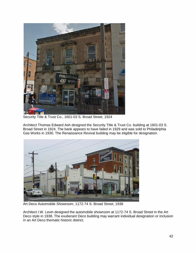
42
Security Title & Trust Co., 1601-03 S. Broad Street, 1924 Architect Thomas Edward Ash designed the Security Title & Trust Co. building at 1601-03 S. Broad Street in 1924. The bank appears to have failed in 1929 and was sold to Philadelphia Gas Works in 1930. The Renaissance Revival building may be eligible for designation.
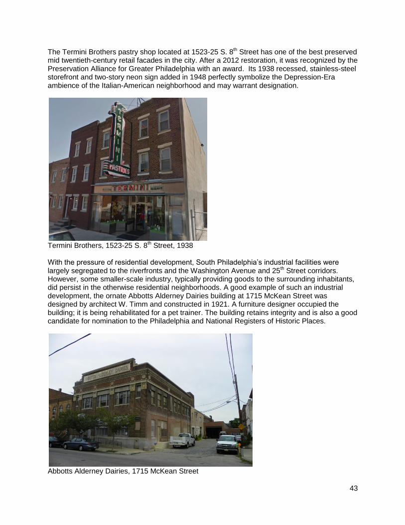
Art Deco Automobile Showroom, 1172-74 S. Broad Street, 1938 Architect I.W. Levin designed the automobile showroom at 1172-74 S. Broad Street in the Art Deco style in 1938. The exuberant Deco building may warrant individual designation or inclusion in an Art Deco thematic historic district.
43
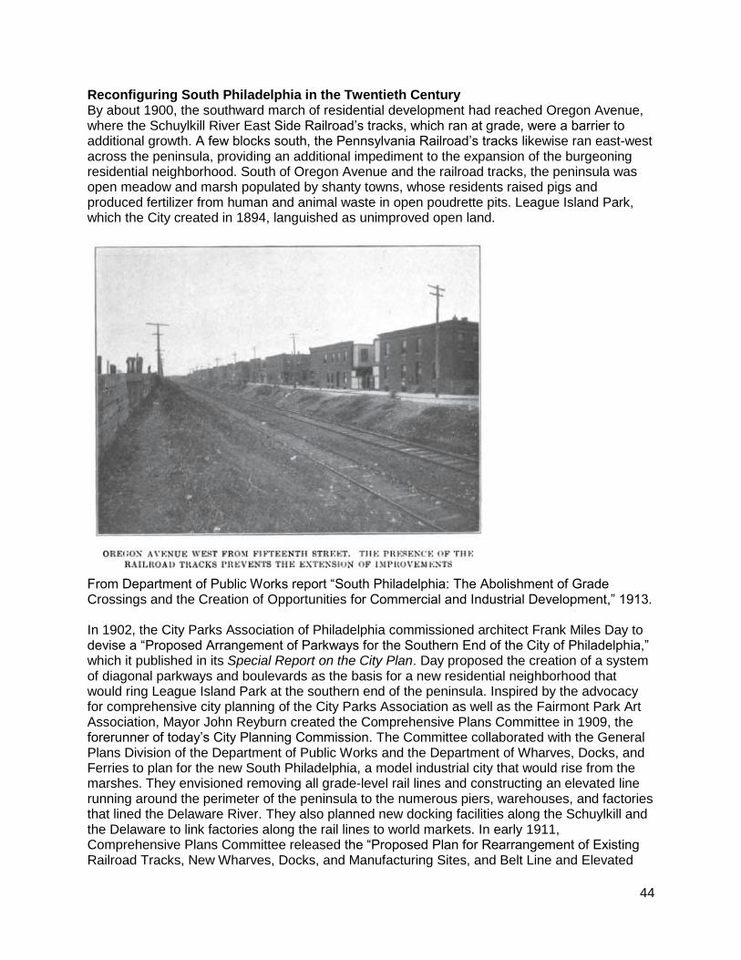
The Termini Brothers pastry shop located at 1523-25 S. 8th Street has one of the best preserved mid twentieth-century retail facades in the city. After a 2012 restoration, it was recognized by the Preservation Alliance for Greater Philadelphia with an award. Its 1938 recessed, stainless-steel storefront and two-story neon sign added in 1948 perfectly symbolize the Depression-Era ambience of the Italian-American neighborhood and may warrant designation.
Termini Brothers, 1523-25 S. 8th Street, 1938 With the pressure of residential development, South Philadelphia’s industrial facilities were largely segregated to the riverfronts and the Washington Avenue and 25th Street corridors. However, some smaller-scale industry, typically providing goods to the surrounding inhabitants, did persist in the otherwise residential neighborhoods. A good example of such an industrial development, the ornate Abbotts Alderney Dairies building at 1715 McKean Street was designed by architect W. Timm and constructed in 1921. A furniture designer occupied the building; it is being rehabilitated for a pet trainer. The building retains integrity and is also a good candidate for nomination to the Philadelphia and National Registers of Historic Places.
Abbotts Alderney Dairies, 1715 McKean Street
44
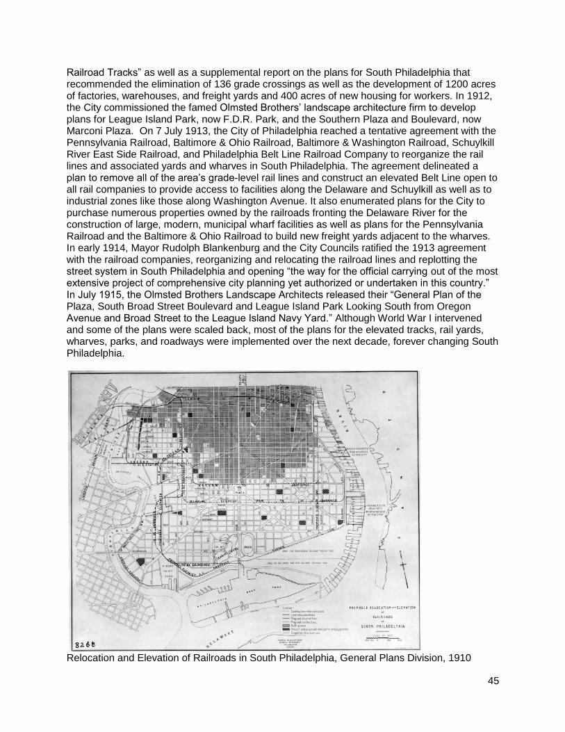
Reconfiguring South Philadelphia in the Twentieth Century By about 1900, the southward march of residential development had reached Oregon Avenue, where the Schuylkill River East Side Railroad’s tracks, which ran at grade, were a barrier to additional growth. A few blocks south, the Pennsylvania Railroad’s tracks likewise ran east-west across the peninsula, providing an additional impediment to the expansion of the burgeoning residential neighborhood. South of Oregon Avenue and the railroad tracks, the peninsula was open meadow and marsh populated by shanty towns, whose residents raised pigs and produced fertilizer from human and animal waste in open poudrette pits. League Island Park, which the City created in 1894, languished as unimproved open land.
From Department of Public Works report “South Philadelphia: The Abolishment of Grade Crossings and the Creation of Opportunities for Commercial and Industrial Development,” 1913. In 1902, the City Parks Association of Philadelphia commissioned architect Frank Miles Day to devise a “Proposed Arrangement of Parkways for the Southern End of the City of Philadelphia,” which it published in its Special Report on the City Plan. Day proposed the creation of a system of diagonal parkways and boulevards as the basis for a new residential neighborhood that would ring League Island Park at the southern end of the peninsula. Inspired by the advocacy for comprehensive city planning of the City Parks Association as well as the Fairmont Park Art Association, Mayor John Reyburn created the Comprehensive Plans Committee in 1909, the forerunner of today’s City Planning Commission. The Committee collaborated with the General Plans Division of the Department of Public Works and the Department of Wharves, Docks, and Ferries to plan for the new South Philadelphia, a model industrial city that would rise from the marshes. They envisioned removing all grade-level rail lines and constructing an elevated line running around the perimeter of the peninsula to the numerous piers, warehouses, and factories that lined the Delaware River. They also planned new docking facilities along the Schuylkill and the Delaware to link factories along the rail lines to world markets. In early 1911, Comprehensive Plans Committee released the “Proposed Plan for Rearrangement of Existing Railroad Tracks, New Wharves, Docks, and Manufacturing Sites, and Belt Line and Elevated
45
Railroad Tracks” as well as a supplemental report on the plans for South Philadelphia that recommended the elimination of 136 grade crossings as well as the development of 1200 acres of factories, warehouses, and freight yards and 400 acres of new housing for workers. In 1912, the City commissioned the famed Olmsted Brothers’ landscape architecture firm to develop plans for League Island Park, now F.D.R. Park, and the Southern Plaza and Boulevard, now Marconi Plaza. On 7 July 1913, the City of Philadelphia reached a tentative agreement with the Pennsylvania Railroad, Baltimore & Ohio Railroad, Baltimore & Washington Railroad, Schuylkill River East Side Railroad, and Philadelphia Belt Line Railroad Company to reorganize the rail lines and associated yards and wharves in South Philadelphia. The agreement delineated a plan to remove all of the area’s grade-level rail lines and construct an elevated Belt Line open to all rail companies to provide access to facilities along the Delaware and Schuylkill as well as to industrial zones like those along Washington Avenue. It also enumerated plans for the City to purchase numerous properties owned by the railroads fronting the Delaware River for the construction of large, modern, municipal wharf facilities as well as plans for the Pennsylvania Railroad and the Baltimore & Ohio Railroad to build new freight yards adjacent to the wharves. In early 1914, Mayor Rudolph Blankenburg and the City Councils ratified the 1913 agreement with the railroad companies, reorganizing and relocating the railroad lines and replotting the street system in South Philadelphia and opening “the way for the official carrying out of the most extensive project of comprehensive city planning yet authorized or undertaken in this country.” In July 1915, the Olmsted Brothers Landscape Architects released their “General Plan of the Plaza, South Broad Street Boulevard and League Island Park Looking South from Oregon Avenue and Broad Street to the League Island Navy Yard.” Although World War I intervened and some of the plans were scaled back, most of the plans for the elevated tracks, rail yards, wharves, parks, and roadways were implemented over the next decade, forever changing South Philadelphia.
Relocation and Elevation of Railroads in South Philadelphia, General Plans Division, 1910
46
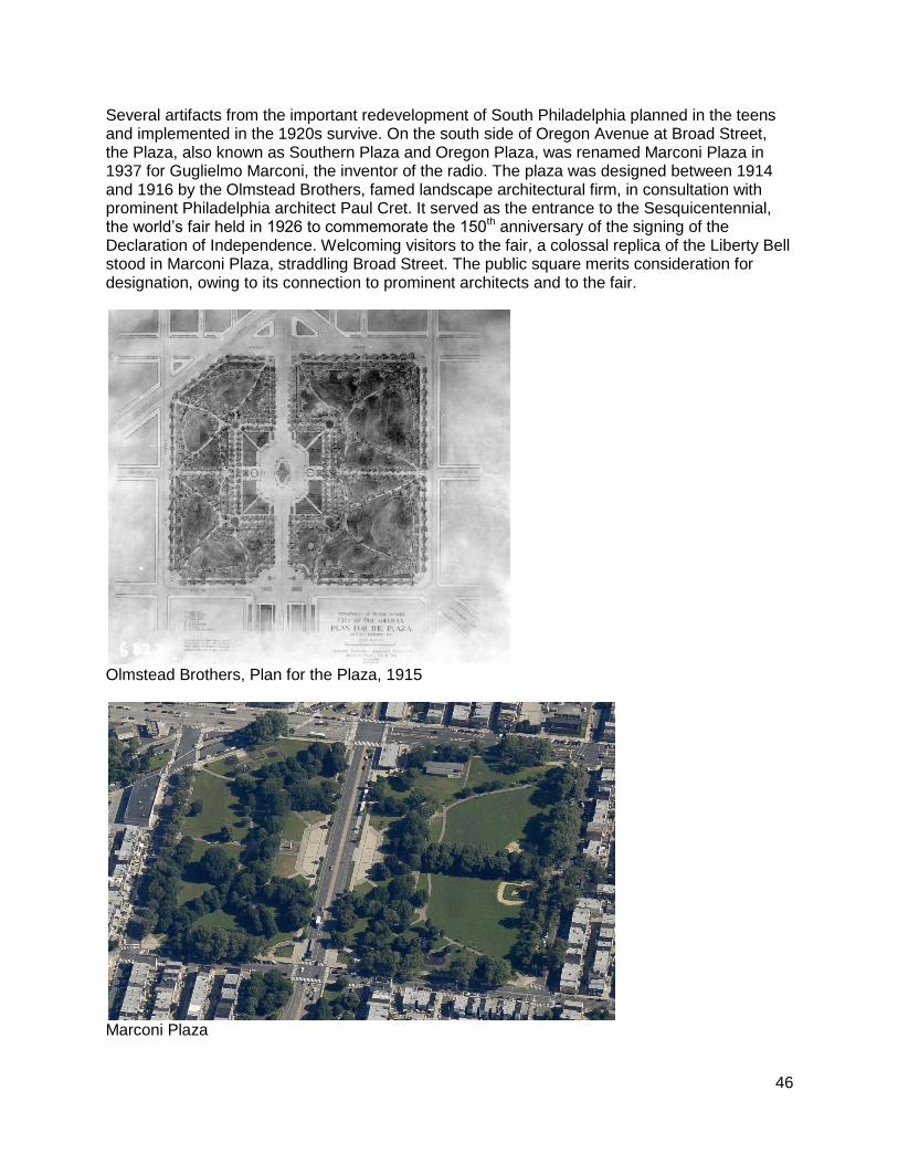
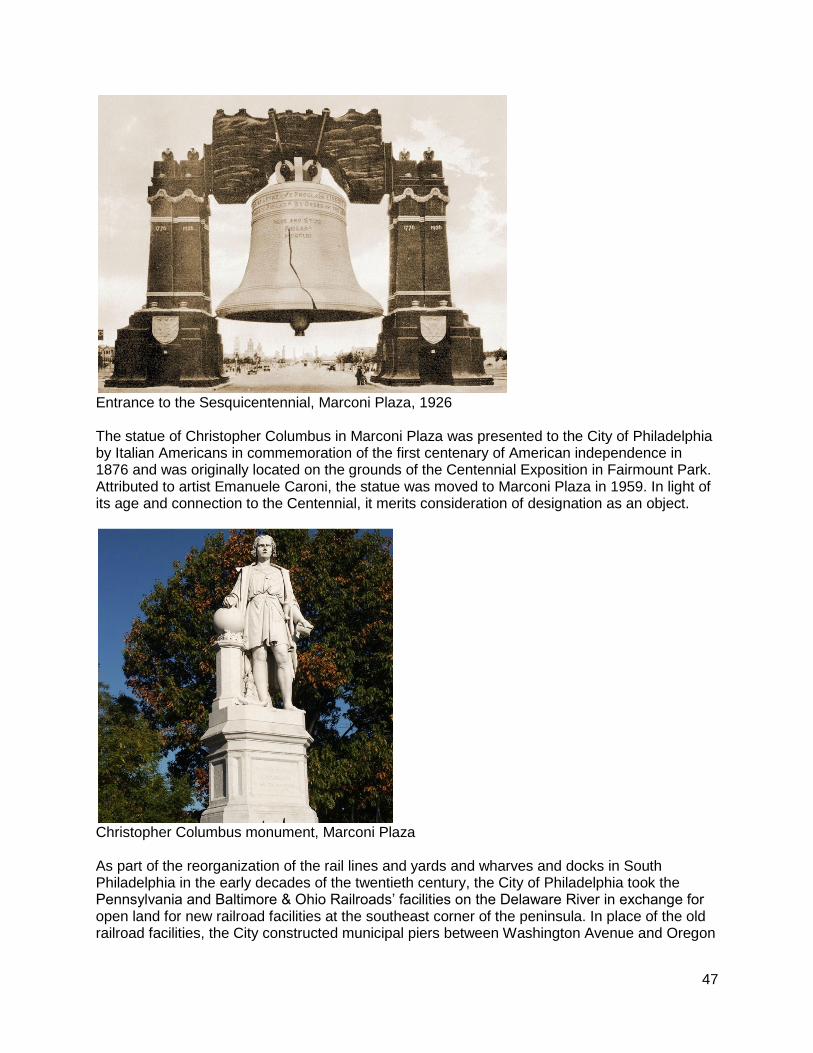
Several artifacts from the important redevelopment of South Philadelphia planned in the teens and implemented in the 1920s survive. On the south side of Oregon Avenue at Broad Street, the Plaza, also known as Southern Plaza and Oregon Plaza, was renamed Marconi Plaza in 1937 for Guglielmo Marconi, the inventor of the radio. The plaza was designed between 1914 and 1916 by the Olmstead Brothers, famed landscape architectural firm, in consultation with prominent Philadelphia architect Paul Cret. It served as the entrance to the Sesquicentennial, the world’s fair held in 1926 to commemorate the 150th anniversary of the signing of the Declaration of Independence. Welcoming visitors to the fair, a colossal replica of the Liberty Bell stood in Marconi Plaza, straddling Broad Street. The public square merits consideration for designation, owing to its connection to prominent architects and to the fair.
Olmstead Brothers, Plan for the Plaza, 1915
Marconi Plaza
47
Entrance to the Sesquicentennial, Marconi Plaza, 1926 The statue of Christopher Columbus in Marconi Plaza was presented to the City of Philadelphia by Italian Americans in commemoration of the first centenary of American independence in 1876 and was originally located on the grounds of the Centennial Exposition in Fairmount Park. Attributed to artist Emanuele Caroni, the statue was moved to Marconi Plaza in 1959. In light of its age and connection to the Centennial, it merits consideration of designation as an object.
Christopher Columbus monument, Marconi Plaza As part of the reorganization of the rail lines and yards and wharves and docks in South Philadelphia in the early decades of the twentieth century, the City of Philadelphia took the Pennsylvania and Baltimore & Ohio Railroads’ facilities on the Delaware River in exchange for open land for new railroad facilities at the southeast corner of the peninsula. In place of the old railroad facilities, the City constructed municipal piers between Washington Avenue and Oregon
48
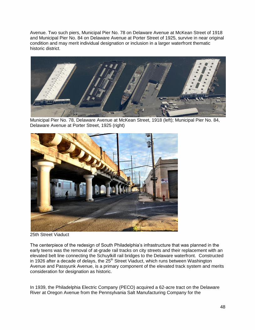
Avenue. Two such piers, Municipal Pier No. 78 on Delaware Avenue at McKean Street of 1918 and Municipal Pier No. 84 on Delaware Avenue at Porter Street of 1925, survive in near original condition and may merit individual designation or inclusion in a larger waterfront thematic historic district.
Municipal Pier No. 78, Delaware Avenue at McKean Street, 1918 (left); Municipal Pier No. 84, Delaware Avenue at Porter Street, 1925 (right)
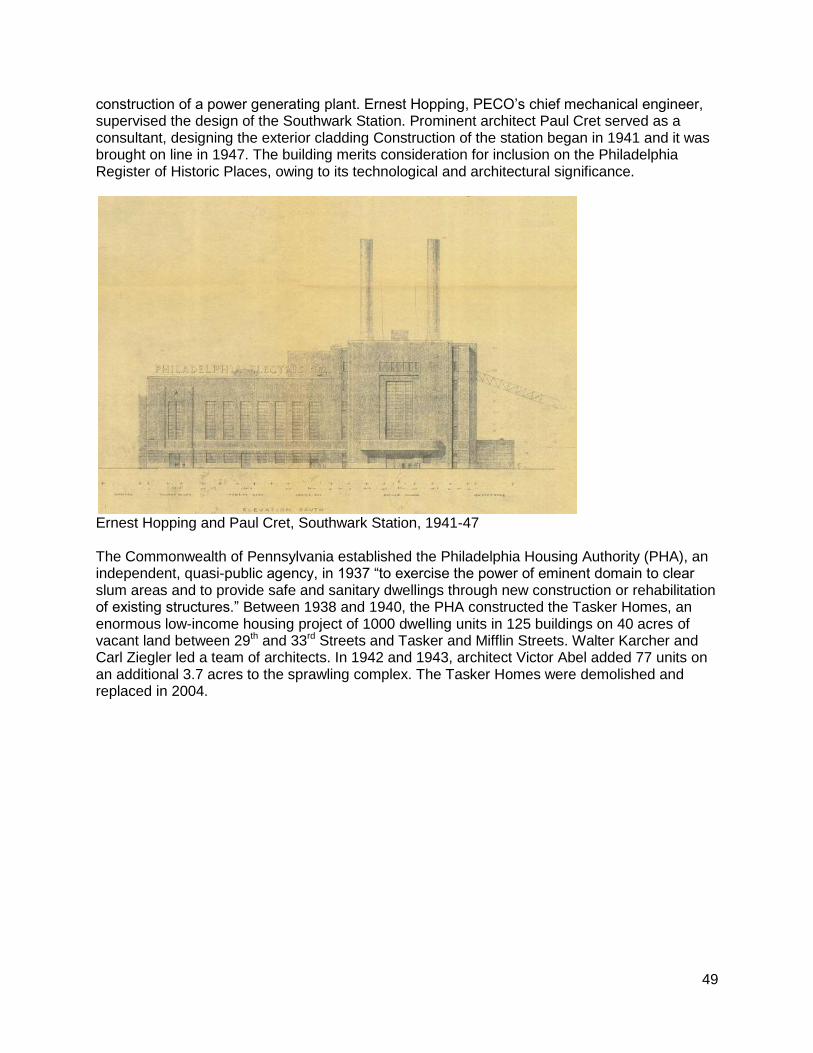
25th Street Viaduct The centerpiece of the redesign of South Philadelphia’s infrastructure that was planned in the early teens was the removal of at-grade rail tracks on city streets and their replacement with an elevated belt line connecting the Schuylkill rail bridges to the Delaware waterfront. Constructed in 1926 after a decade of delays, the 25th Street Viaduct, which runs between Washington Avenue and Passyunk Avenue, is a primary component of the elevated track system and merits consideration for designation as historic. In 1939, the Philadelphia Electric Company (PECO) acquired a 62-acre tract on the Delaware River at Oregon Avenue from the Pennsylvania Salt Manufacturing Company for the
49
construction of a power generating plant. Ernest Hopping, PECO’s chief mechanical engineer, supervised the design of the Southwark Station. Prominent architect Paul Cret served as a consultant, designing the exterior cladding Construction of the station began in 1941 and it was brought on line in 1947. The building merits consideration for inclusion on the Philadelphia Register of Historic Places, owing to its technological and architectural significance.
Ernest Hopping and Paul Cret, Southwark Station, 1941-47 The Commonwealth of Pennsylvania established the Philadelphia Housing Authority (PHA), an independent, quasi-public agency, in 1937 “to exercise the power of eminent domain to clear slum areas and to provide safe and sanitary dwellings through new construction or rehabilitation of existing structures.” Between 1938 and 1940, the PHA constructed the Tasker Homes, an enormous low-income housing project of 1000 dwelling units in 125 buildings on 40 acres of vacant land between 29th and 33rd Streets and Tasker and Mifflin Streets. Walter Karcher and Carl Ziegler led a team of architects. In 1942 and 1943, architect Victor Abel added 77 units on an additional 3.7 acres to the sprawling complex. The Tasker Homes were demolished and replaced in 2004.
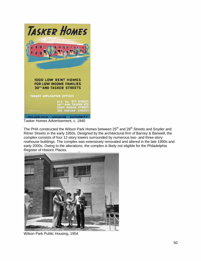
50
Tasker Homes Advertisement, c. 1940 The PHA constructed the Wilson Park Homes between 25th and 28th Streets and Snyder and Ritner Streets in the early 1950s. Designed by the architectural firm of Barney & Banwell, the complex consists of four 12-story towers surrounded by numerous two- and three-story rowhouse buildings. The complex was extensively renovated and altered in the late 1990s and early 2000s. Owing to the alterations, the complex is likely not eligible for the Philadelphia Register of Historic Places.
Wilson Park Public Housing, 1954
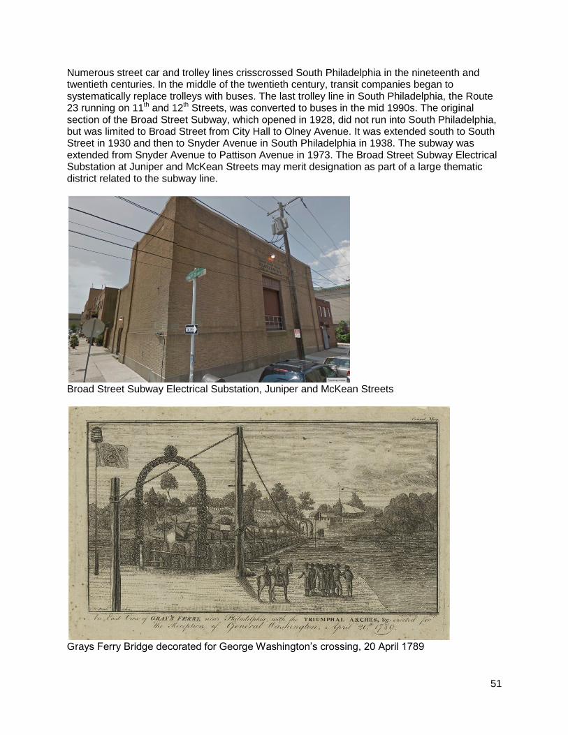
51
Numerous street car and trolley lines crisscrossed South Philadelphia in the nineteenth and twentieth centuries. In the middle of the twentieth century, transit companies began to systematically replace trolleys with buses. The last trolley line in South Philadelphia, the Route 23 running on 11th and 12th Streets, was converted to buses in the mid 1990s. The original section of the Broad Street Subway, which opened in 1928, did not run into South Philadelphia, but was limited to Broad Street from City Hall to Olney Avenue. It was extended south to South Street in 1930 and then to Snyder Avenue in South Philadelphia in 1938. The subway was extended from Snyder Avenue to Pattison Avenue in 1973. The Broad Street Subway Electrical Substation at Juniper and McKean Streets may merit designation as part of a large thematic district related to the subway line.
Broad Street Subway Electrical Substation, Juniper and McKean Streets
Grays Ferry Bridge decorated for George Washington’s crossing, 20 April 1789
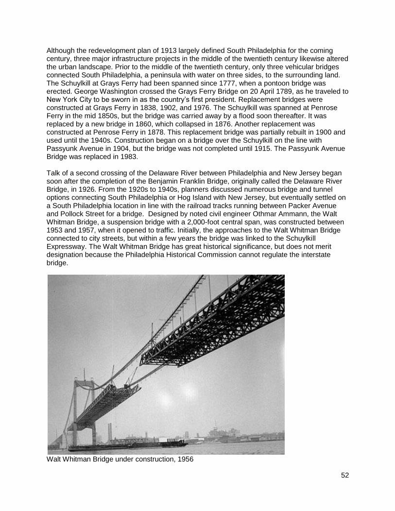
52
Although the redevelopment plan of 1913 largely defined South Philadelphia for the coming century, three major infrastructure projects in the middle of the twentieth century likewise altered the urban landscape. Prior to the middle of the twentieth century, only three vehicular bridges connected South Philadelphia, a peninsula with water on three sides, to the surrounding land. The Schuylkill at Grays Ferry had been spanned since 1777, when a pontoon bridge was erected. George Washington crossed the Grays Ferry Bridge on 20 April 1789, as he traveled to New York City to be sworn in as the country’s first president. Replacement bridges were constructed at Grays Ferry in 1838, 1902, and 1976. The Schuylkill was spanned at Penrose Ferry in the mid 1850s, but the bridge was carried away by a flood soon thereafter. It was replaced by a new bridge in 1860, which collapsed in 1876. Another replacement was constructed at Penrose Ferry in 1878. This replacement bridge was partially rebuilt in 1900 and used until the 1940s. Construction began on a bridge over the Schuylkill on the line with Passyunk Avenue in 1904, but the bridge was not completed until 1915. The Passyunk Avenue Bridge was replaced in 1983. Talk of a second crossing of the Delaware River between Philadelphia and New Jersey began soon after the completion of the Benjamin Franklin Bridge, originally called the Delaware River Bridge, in 1926. From the 1920s to 1940s, planners discussed numerous bridge and tunnel options connecting South Philadelphia or Hog Island with New Jersey, but eventually settled on a South Philadelphia location in line with the railroad tracks running between Packer Avenue and Pollock Street for a bridge. Designed by noted civil engineer Othmar Ammann, the Walt Whitman Bridge, a suspension bridge with a 2,000-foot central span, was constructed between 1953 and 1957, when it opened to traffic. Initially, the approaches to the Walt Whitman Bridge connected to city streets, but within a few years the bridge was linked to the Schuylkill Expressway. The Walt Whitman Bridge has great historical significance, but does not merit designation because the Philadelphia Historical Commission cannot regulate the interstate bridge.
Walt Whitman Bridge under construction, 1956
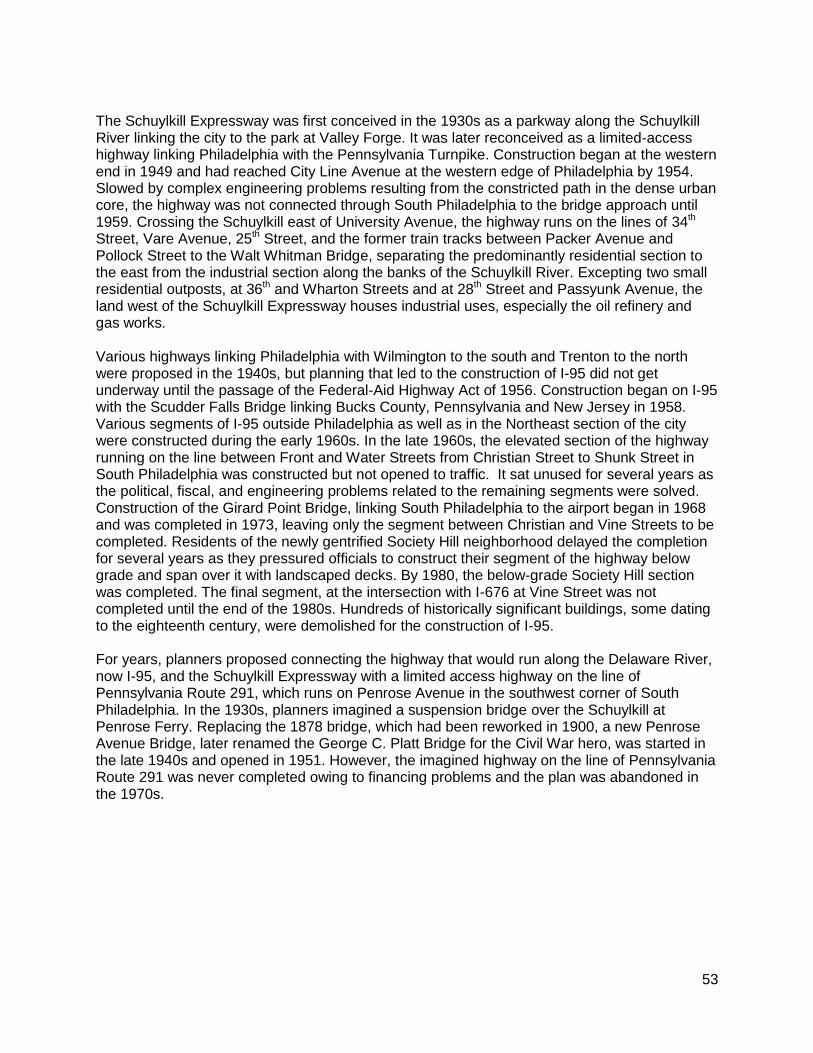
53
The Schuylkill Expressway was first conceived in the 1930s as a parkway along the Schuylkill River linking the city to the park at Valley Forge. It was later reconceived as a limited-access highway linking Philadelphia with the Pennsylvania Turnpike. Construction began at the western end in 1949 and had reached City Line Avenue at the western edge of Philadelphia by 1954. Slowed by complex engineering problems resulting from the constricted path in the dense urban core, the highway was not connected through South Philadelphia to the bridge approach until 1959. Crossing the Schuylkill east of University Avenue, the highway runs on the lines of 34th Street, Vare Avenue, 25th Street, and the former train tracks between Packer Avenue and Pollock Street to the Walt Whitman Bridge, separating the predominantly residential section to the east from the industrial section along the banks of the Schuylkill River. Excepting two small residential outposts, at 36th and Wharton Streets and at 28th Street and Passyunk Avenue, the land west of the Schuylkill Expressway houses industrial uses, especially the oil refinery and gas works. Various highways linking Philadelphia with Wilmington to the south and Trenton to the north were proposed in the 1940s, but planning that led to the construction of I-95 did not get underway until the passage of the Federal-Aid Highway Act of 1956. Construction began on I-95 with the Scudder Falls Bridge linking Bucks County, Pennsylvania and New Jersey in 1958. Various segments of I-95 outside Philadelphia as well as in the Northeast section of the city were constructed during the early 1960s. In the late 1960s, the elevated section of the highway running on the line between Front and Water Streets from Christian Street to Shunk Street in South Philadelphia was constructed but not opened to traffic. It sat unused for several years as the political, fiscal, and engineering problems related to the remaining segments were solved. Construction of the Girard Point Bridge, linking South Philadelphia to the airport began in 1968 and was completed in 1973, leaving only the segment between Christian and Vine Streets to be completed. Residents of the newly gentrified Society Hill neighborhood delayed the completion for several years as they pressured officials to construct their segment of the highway below grade and span over it with landscaped decks. By 1980, the below-grade Society Hill section was completed. The final segment, at the intersection with I-676 at Vine Street was not completed until the end of the 1980s. Hundreds of historically significant buildings, some dating to the eighteenth century, were demolished for the construction of I-95. For years, planners proposed connecting the highway that would run along the Delaware River, now I-95, and the Schuylkill Expressway with a limited access highway on the line of Pennsylvania Route 291, which runs on Penrose Avenue in the southwest corner of South Philadelphia. In the 1930s, planners imagined a suspension bridge over the Schuylkill at Penrose Ferry. Replacing the 1878 bridge, which had been reworked in 1900, a new Penrose Avenue Bridge, later renamed the George C. Platt Bridge for the Civil War hero, was started in the late 1940s and opened in 1951. However, the imagined highway on the line of Pennsylvania Route 291 was never completed owing to financing problems and the plan was abandoned in the 1970s.
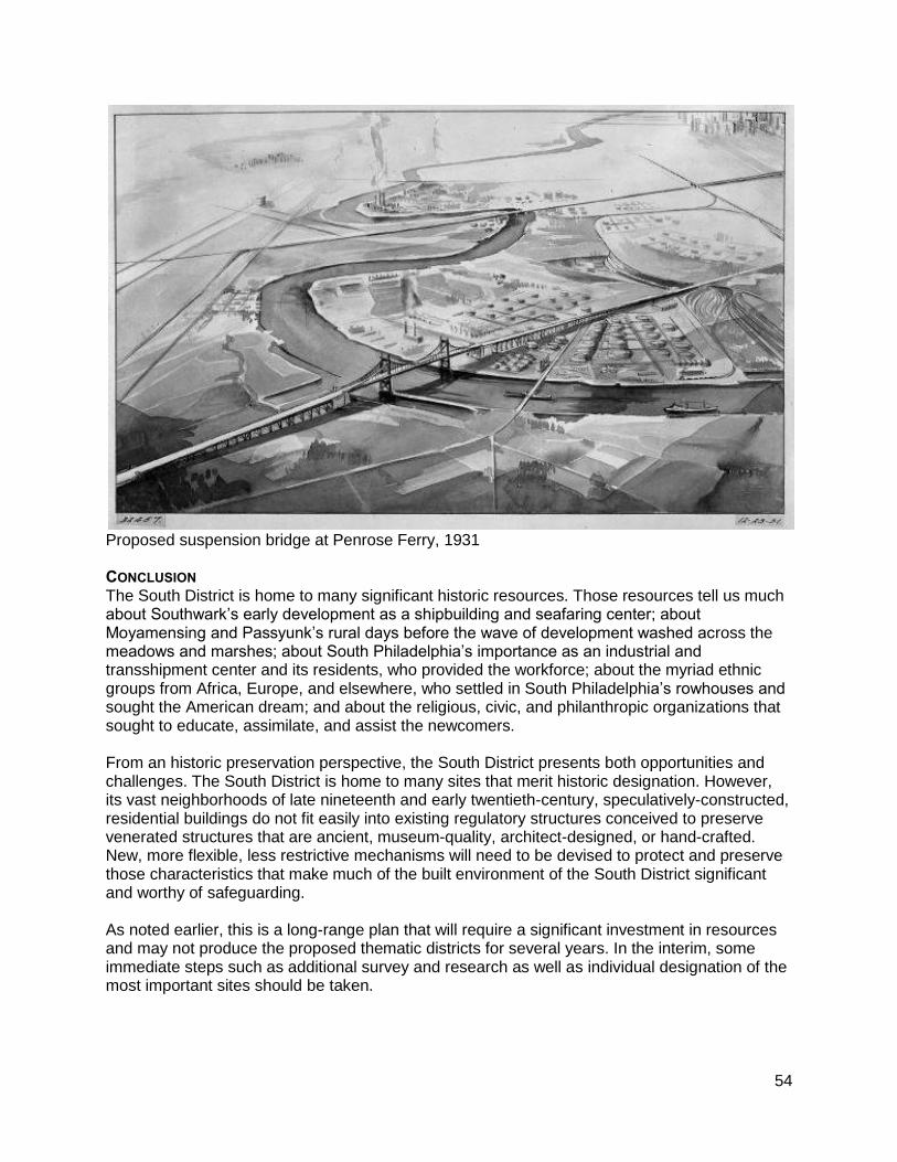
54
Proposed suspension bridge at Penrose Ferry, 1931 CONCLUSION The South District is home to many significant historic resources. Those resources tell us much about Southwark’s early development as a shipbuilding and seafaring center; about Moyamensing and Passyunk’s rural days before the wave of development washed across the meadows and marshes; about South Philadelphia’s importance as an industrial and transshipment center and its residents, who provided the workforce; about the myriad ethnic groups from Africa, Europe, and elsewhere, who settled in South Philadelphia’s rowhouses and sought the American dream; and about the religious, civic, and philanthropic organizations that sought to educate, assimilate, and assist the newcomers. From an historic preservation perspective, the South District presents both opportunities and challenges. The South District is home to many sites that merit historic designation. However, its vast neighborhoods of late nineteenth and early twentieth-century, speculatively-constructed, residential buildings do not fit easily into existing regulatory structures conceived to preserve venerated structures that are ancient, museum-quality, architect-designed, or hand-crafted. New, more flexible, less restrictive mechanisms will need to be devised to protect and preserve those characteristics that make much of the built environment of the South District significant and worthy of safeguarding. As noted earlier, this is a long-range plan that will require a significant investment in resources and may not produce the proposed thematic districts for several years. In the interim, some immediate steps such as additional survey and research as well as individual designation of the most important sites should be taken.
55
APPENDIX: ADDITIONAL HOUSES OF WORSHIP AND SCHOOLS THAT MAY MERIT DESIGNATION Houses of Worship:
Epiphany of Our Lord Church, 1101 Jackson Street
Annunciation Blessed Virgin Mary (B.V.M.) Catholic Church, 1501 S. 10th Street
New Gethsemane Baptist Church of South Philadelphia, 2301 Wharton Street
St. Philip’s Memorial Episcopal Church, 2633-2645 Wharton Street
Bryant Baptist Church, 1144 S. 19th Street
Mount Hebron Baptist Church, 1409-1417 Wharton Street
Christ's Presbyterian Church, 1010 S. 10th Street
St. Casimir Catholic Church, 324 Wharton Street
Calvary African Methodist Episcopal Church, 612 Dickinson Street
Emmanuel Chapel, 835 Reed Street
St. Barnabas Bethsaida United Methodist Church, 1812-1814 Wharton Street
Second Nazareth Missionary Baptist Church, 1600-1610 S. 18th Street
Church of Saint Simon the Cyrenian, Episcopal, 1401-1411 S. 22nd Street
Zion African Methodist Episcopal Church, 1600-1606 S. 21st Street
Baptist Church of the Redeemer, 1440-1446 S. 24th Street
Former St. Aloysius Catholic Church, 2604-2608 Tasker Street
Former King of Peace Catholic Church, 1301 S. 26th Street
Williams Temple Christian Methodist Episcopal Church, 3131-3133 Reed Street
Holy Ghost Byzantine Catholic Church, 2300 S. 24th Street
Assumption of Holy Virgin Orthodox Church, 2101-2111 S. 28th Street
St. Edmond Catholic Church, 2100 S. 21st Street (to merge with St. Monica)
New Comfort Baptist Church, 2200-2214 Snyder Avenue
St. Richard of Chichester Catholic Church, 1800 Pollock Street (to merge with Holy Spirit)
Philadelphia Praise Center, 1701-1705 McKean Street
First Christian Assembly, 1900 S. 11th Street
City Church of Philadelphia, 2311 S. 13th Street
Mount Enon Baptist Church, 500 Snyder Avenue
Cambodian Students Council, 2353-2355 S. Marshall Street
St. Luke’s Snyder Avenue United Methodist Church, 440 Snyder Avenue
Our Lady of Mount Carmel Catholic Church, 2301-2341 S. 3rd Street
Snyder Avenue Congregational Church, 300 Snyder Avenue School buildings:
Anthony Wayne School, 2700 Morris Street, converted to senior housing
George W. Childs School, 1501 S. 17th Street
Delaplaine McDaniel Public School, 1801 S. 22nd Street
Edwin H. Vare Junior High School, 2102 S. 24th Street
F. Amadee Bregy Public School, 1700 Bigler Street
James Alcorn School, 3200 Dickinson Street
Walter George Smith Public School, 1900 Wharton Street
Norris Barrett/Jeremiah Nichols School, 1235 S. 16th Street
Eliza B. Kirkbride School, 1501 S. 7th Street
James Wilson Public School; Annunciation BVM; Wharton Street Lofts, 1150 Wharton Street
56
Federal Street School; Andrew Jackson School, 1213 S. 12th Street
George Washington Public School, 1198 S. 5th Street
George W. Nebinger Public School, 627 Carpenter Street
Southwark School, 1821 S. 9th Street
George Sharswood School, 2300 S. 2nd Street
D. Newlin Fell School, 900 Oregon Ave.
George C. Thomas School, 2746 S. 9th Street
A.S. Jenks School, 1245 W. Moyamensing Street
John H. Taggart School, 2501 S. 5th Street