HISTORIC LAND USE TEAM: PHASE I REPORT ON GENERALIZED LAND USE
24
CENTRAL ARIZONA - PHOENIX LONG-TERM ECOLOGICAL RESEARCH CONTRIBUTION NO. 1 HISTORIC LAND USE TEAM: PHASE I REPORT ON GENERALIZED LAND USE Kim Knowles-Yánez Cherie Moritz Jana Fry Charles L. Redman Matt Bucchin Peter H. McCartney August 1999
Transcript of HISTORIC LAND USE TEAM: PHASE I REPORT ON GENERALIZED LAND USE

CENTRAL ARIZONA - PHOENIX LONG-TERM ECOLOGICAL RESEARCH
CONTRIBUTION NO. 1
HISTORIC LAND USE TEAM:PHASE I REPORT ON
GENERALIZED LAND USE
Kim Knowles-YánezCherie Moritz
Jana FryCharles L. Redman
Matt BucchinPeter H. McCartney
August 1999

The Central Arizona-Phoenix Long Term Ecological Research (CAP LTER) project at Arizona State University was funded in 1997 by the NationalScience Foundation (DEB 9714833) to be one of the first urban sites in the LTER network. CAP LTER provides a unique addition to LTERresearch by focusing upon an arid-land ecosystem profoundly influenced and defined by the presence and activities of humans. Our investigationof land use and ecological consequences in an urban environment also involves community partners and K-12 schools. Our aim is to understandthe changing urban fabric of our arid urban ecosystem and to offer applications to arid cities across the globe.
CENTRAL ARIZONA - PHOENIX LONG-TERM ECOLOGICAL RESEARCH
CONTRIBUTION NO. 1
HISTORIC LAND USE TEAM:PHASE I REPORT ON
GENERALIZED LAND USEKim Knowles-Yánez
Cherie MoritzJana Fry
Charles L. RedmanMatt Bucchin
Peter H. McCartney
CENTER FOR ENVIRONMENTAL STUDIES
ARIZONA STATE UNIVERSITY
P.O. BOX 873211TEMPE, AZ 85287-3211
(480) 965-2975HTTP://CAPLTER.ASU.EDU

TABLE OF CONTENTSPage
Introduction . . . . . . . . . . . . . . . . . . . . . . . . . . . . . . . . . . . . . . . . . . . . . . . . . . . . . . . . . . . . . . . . . . . . . . . . 1
Maps . . . . . . . . . . . . . . . . . . . . . . . . . . . . . . . . . . . . . . . . . . . . . . . . . . . . . . . . . . . . . . . . . . . . . . . . . . . . . . 1
1912 . . . . . . . . . . . . . . . . . . . . . . . . . . . . . . . . . . . . . . . . . . . . . . . . . . . . . . . . . . . . . . . . . . . . . . . . . . . . . . 2History . . . . . . . . . . . . . . . . . . . . . . . . . . . . . . . . . . . . . . . . . . . . . . . . . . . . . . . . . . . . . . . . . . . . . . . . . 2Settlement Pattern . . . . . . . . . . . . . . . . . . . . . . . . . . . . . . . . . . . . . . . . . . . . . . . . . . . . . . . . . . . . . . . . 2Data Sources . . . . . . . . . . . . . . . . . . . . . . . . . . . . . . . . . . . . . . . . . . . . . . . . . . . . . . . . . . . . . . . . . . . . 4
1934 . . . . . . . . . . . . . . . . . . . . . . . . . . . . . . . . . . . . . . . . . . . . . . . . . . . . . . . . . . . . . . . . . . . . . . . . . . . . . . 5History . . . . . . . . . . . . . . . . . . . . . . . . . . . . . . . . . . . . . . . . . . . . . . . . . . . . . . . . . . . . . . . . . . . . . . . . . 5Settlement Pattern . . . . . . . . . . . . . . . . . . . . . . . . . . . . . . . . . . . . . . . . . . . . . . . . . . . . . . . . . . . . . . . . 5Data Sources . . . . . . . . . . . . . . . . . . . . . . . . . . . . . . . . . . . . . . . . . . . . . . . . . . . . . . . . . . . . . . . . . . . . 6
1955 . . . . . . . . . . . . . . . . . . . . . . . . . . . . . . . . . . . . . . . . . . . . . . . . . . . . . . . . . . . . . . . . . . . . . . . . . . . . . . 7History . . . . . . . . . . . . . . . . . . . . . . . . . . . . . . . . . . . . . . . . . . . . . . . . . . . . . . . . . . . . . . . . . . . . . . . . . 7Settlement Pattern . . . . . . . . . . . . . . . . . . . . . . . . . . . . . . . . . . . . . . . . . . . . . . . . . . . . . . . . . . . . . . . . 8Data Sources . . . . . . . . . . . . . . . . . . . . . . . . . . . . . . . . . . . . . . . . . . . . . . . . . . . . . . . . . . . . . . . . . . . . 9
1975 . . . . . . . . . . . . . . . . . . . . . . . . . . . . . . . . . . . . . . . . . . . . . . . . . . . . . . . . . . . . . . . . . . . . . . . . . . . . . . 9History . . . . . . . . . . . . . . . . . . . . . . . . . . . . . . . . . . . . . . . . . . . . . . . . . . . . . . . . . . . . . . . . . . . . . . . . . 9Settlement Pattern . . . . . . . . . . . . . . . . . . . . . . . . . . . . . . . . . . . . . . . . . . . . . . . . . . . . . . . . . . . . . . . 10Data Sources . . . . . . . . . . . . . . . . . . . . . . . . . . . . . . . . . . . . . . . . . . . . . . . . . . . . . . . . . . . . . . . . . . . 11
1995 . . . . . . . . . . . . . . . . . . . . . . . . . . . . . . . . . . . . . . . . . . . . . . . . . . . . . . . . . . . . . . . . . . . . . . . . . . . . . 11History . . . . . . . . . . . . . . . . . . . . . . . . . . . . . . . . . . . . . . . . . . . . . . . . . . . . . . . . . . . . . . . . . . . . . . . . 11Settlement Pattern . . . . . . . . . . . . . . . . . . . . . . . . . . . . . . . . . . . . . . . . . . . . . . . . . . . . . . . . . . . . . . . 13Data Sources . . . . . . . . . . . . . . . . . . . . . . . . . . . . . . . . . . . . . . . . . . . . . . . . . . . . . . . . . . . . . . . . . . . 13
Land-Use Transition . . . . . . . . . . . . . . . . . . . . . . . . . . . . . . . . . . . . . . . . . . . . . . . . . . . . . . . . . . . . . . . . 14
Phase II Planning . . . . . . . . . . . . . . . . . . . . . . . . . . . . . . . . . . . . . . . . . . . . . . . . . . . . . . . . . . . . . . . . . . . 17
Literature Cited . . . . . . . . . . . . . . . . . . . . . . . . . . . . . . . . . . . . . . . . . . . . . . . . . . . . . . . . . . . . . . . . . . . . 19
How to Obtain Data and Copies of This Report . . . . . . . . . . . . . . . . . . . . . . . . . . . . . . . . . . . . . . . . . . . 21
List of Contributions . . . . . . . . . . . . . . . . . . . . . . . . . . . . . . . . . . . . . . . . . . . . . . . . . . . . . . . . . . . . . . . . 21

*Present address: Urban and Regional Planning, Liberal Studies Program, California State University-SanMarcos, San Marcos CA 92096-0001.
1
PHASE I REPORT ON GENERALIZED LAND USE
Kim Knowles-Yánez1,*, Cherie Moritz1, Jana Fry2, Charles L. Redman1
Matt Bucchin1, and Peter H. McCartney3
1Center for Environmental Studies, Arizona State University, PO Box 873211, Tempe AZ 85287-3211;2Information Technology, Arizona State University, PO Box 870101, Tempe AZ 85287-0101; and
3Archaeological Research Institute, Arizona State University, PO Box 872402, Tempe AZ 85287-2402
INTRODUCTION
The Central Arizona-Phoenix Long Term Ecological Research (CAP LTER) project at Arizona StateUniversity has engaged a number of research teams in topics as diverse as aquatic core sampling and urbanfringe morphology in CAP LTER s charge to understand the ecology of the Phoenix urban ecosystem. Thisreport discusses Phase I (conducted fall of 1998) of one of those projects, the Historic Land Use Project.During this phase, geographical information system (GIS) software and diverse data sources were used tomap the pattern of generalized desert, agricultural, recreational, and urban land uses for the Phoenixmetropolitan area for the approximate periods: 1912, 1934, 1955, 1975, 1995.
This report provides a brief history, an outline of the settlement pattern changes, and the data sourcesused in creating maps for each of the periods. Although interpretations of the patterns are suggested, theyremain tentative and the reader is urged to assess any analysis of this data in light of the caveats explainedin this report.
Our desire is to provide a general background while making our methods and decisions evident tosubsequent researchers who will want to use our data for their own purposes. Federal Geographic DataCommittee (FGDC)-compliant metadata is available for the data discussed in this report at the followingwebsite: http://caplter.asu.edu
MAPS
Maps and tables for the Salt River Valley - Phoenix metropolitan area showing generalized land use wereproduced for the approximate periods of 1912, 1934, 1955, 1975, and 1995. Although specific years areassociated with each map, reflecting the primary source of data, they in reality are compilations of data froma series of years around that midpoint. Each map utilizes a topographic relief image as its background. Thisimage was created from U.S. Geological Survey (USGS) Digital Elevation Model 1:250,000 data. Ahillshade layer was calculated from the raw data using a solar zenith angle of 25Eand azimuth of 315E. Thishillshade layer was added to each map as an image.
The maps also show streams and lakes taken from the Arizona Land Resource Information System(ALRIS) database, provided by the Arizona State Land Department. All lakes shown are man-made and wereadded to the appropriate period map, based on dam establishment information from the Salt River Projectweb site (http://www.srp.gov). For the land-use classifications, we employed spatial data from varioussources as noted herein. For GIS mapping and analysis, the project used ArcView software, produced byEnvironmental Systems Research Institute, Inc.

CENTRAL ARIZONA - PHOENIX LONG-TERM ECOLOGICAL RESEARCH
2
1912
HistoryThe Salt River Valley lies in the Sonoran Desert in the Basin and Range Province of North America. The
Valley contains broad, gentle slopes with rich alluvial deposits and well-drained loamy soils. The Salt Riverflows through the Valley and has historically provided an abundant source of water. The Hohokamcivilization beginning in 500-700 AD excavated canals to water crops of beans, corn, squash, and cotton.However, the Valley was largely abandoned by 1400 and was subsequently under Spanish, Mexican, andU.S. rule, but remained largely unsettled until the late 1800s. In 1863 President Lincoln established theArizona Territory, and in 1867 the first hay camps were established along the river. In 1870 a Phoenixtownsite was delineated to include present-day streets of Central and Washington (Mawn 1979).
Agriculture played a predominant role in the Valley between 1870 and 1920, by which time Phoenix hadestablished itself as the largest city in Arizona. The availability of water from the river determined the initialdevelopment pattern, following re-excavation and extension of the Hohokam canals. Agriculture wasdiversified in these early years and wheat, barley, and corn became the first surplus crops. Later, commercialcitrus and fruit crops flourished. Still later on, alfalfa developed as a cash crop and contributed to cattle,horse, and sheep ranching. Dairies were established as well as an ostrich feather industry. In 1902 theNational Reclamation Act spurred creation of the quasi-federal Salt River Valley Water User’s Association(SRVWUA) who took over private control of canal development and sponsored the Roosevelt Dam Project.Roosevelt Dam was completed in 1911 and provided a steady reliable water source to the Valley, greatlydiminishing historical flooding and drought potential. After the construction of Roosevelt Dam, cottonbecame another important cash crop. The area was actively promoted as a rural area to encourage growthalong the agriculture periphery (Mawn 1979).
In 1895 the first railroad service linked the Phoenix area to Southwest, Midwest, and Eastern markets.Street car and trolley line expansion occurred between 1887 and 1915. Between 1900 and 1920, the autofurthered outward development to suburbs that grew up to the north of downtown Phoenix (Mawn 1979).
By the end of its first stage of development, Phoenix was a compact and well-defined city with functionalzones for a central business district, industry and residential districts. It had established itself as the adominant market center between El Paso and Los Angeles (Mawn 1979).
Settlement PatternThe population of Phoenix and all of Maricopa County, at this point, was small (see Table 1), distributed
in agricultural communities established to take advantage of the possibilities of irrigation from the Salt River.The communities of Phoenix, Tempe, and Mesa, using re-excavated prehistoric canals, mirrored thedistribution of major Hohokam settlements in the Valley. The year 1912 is a fine baseline to begin this studyin that it represents a major turning point for Phoenix. Roosevelt Dam had been completed, expanding thepossibility for irrigation as well as offering more protection against flooding. Phoenix had also been namedthe capital of the newly admitted 48th state in the Union. The major towns were located in the floodplain, onlya short distance from the main channel of the Salt River. Some settlements, such as Chandler and Glendale,were substantially farther from the river channel, but still within the reach of the irrigation canals. All of thetown development was carved out of potentially useful agricultural land.

REPORT ON GENERALIZED LAND USE
3
TABLE 1. Selected Maricopa County census information: population and approximate land area (km2)
Census Year/Population/Area
MaricopaCounty
City ofChandler
City ofGlendale
City ofMesa
City ofPhoenix
City ofScottsdale
City ofTempe
1995 Population 2,551,765 132,360 182,615 338,117 1,149,417 168,176 153,821
Area 23,988 133 140 317 1,220 478 103
1990 Population 2,122,101 89,862 147,864 288,104 983,392 130,075 141,993
Area 23,930 125 136 284 1,100 478 103
1980 Population 1,509,175 29,673 97,172 152,404 789,704 88,622 106,920
Area 23,730 74 106 175 860 230 94
1970 Population 971,228 13,763 36,228 63,049 584,303 67,823 63,550
Area 23,803 17 44 63 645 175 66
1960 Population 663,510 9,531 15,893 33,772 439,170 10,026 24,897
Area 6 10 36 487 10 46
1950 Population 331,770 3,799 8,179 16,790 106,818 2,032 7,684
Area 23,988 2 3 17 43 7
1940 Population 186,193 1,239 4,855 7,224 65,414 **2,000 2,906
Area 24,001 1 3 5 25 5
1930 Population 150,970 1,378 3,665 3,711 48,118 *2,761 2,495
Area 1 3 3 17 5
1920 Population 89,576 2,737 3,036 29,053 *1,047 1,963
Area 23,117 **13 5
1910 Population 34,488 *1,000 1,692 11,134 1,473
Area 23,117 **8 5
1900 Population 20,457 722 5,544 885
Area 22,922 **5 5
1890 Population 10,986 **500 3,152 **500
Area **1
1880 Population 5,689 151 1,708 135
Area **1
1870 Population 240
Area **1*Precinct figure: includes all those who voted in the population center. This figure was usually greater than the
actual population. **County or City Planning Department estimates (rounded).
SOURCES: Primarily U.S. Census Bureau reports, abstracts, and web site, and 1995 Special Census of MaricopaCounty. Also consulted were publications and web sites by Arizona Department of Economic Security,Population Statistics Unit; Maricopa Association of Governments; Greater Phoenix Economic Council; MaricopaCounty; City of Phoenix, Planning Department; City of Tempe, Development Services; and City of Chandler.

CENTRAL ARIZONA - PHOENIX LONG-TERM ECOLOGICAL RESEARCH
4
Data SourcesAgriculture in the Salt River Valley almost always requires irrigation. John Keane, of the Salt River
Project (SRP), provided SRP spatial data produced in relation to the Kent Decree of 1910. This dataset givesthe location of SRP-irrigated lands and when they began receiving irrigation, from which we inferred theyears in which the lands were put into production. Keane also provided spatial data related to the SRVWUAirrigation districts. Agricultural production dates for these non-SRP districts were obtained from personalcommunication with Keane and with representatives of the districts. The Kent Decree data were classifiedinto three categories: A, B, and C. The A category contained those lands that were in cultivation in 1910, theB category contained those lands that were in cultivation prior to 1910 but not in cultivation in 1912, and theC category contained those lands that were not cultivated in 1910 but were by 1925, approximately. Weclassified all A and B lands as agriculture. Additionally, all SRVWUA districts that were established in 1912or before were categorized as agriculture.
Urban lands were primarily obtained from 1:24,000 USGS topographic maps for the area, available inthe Arizona State University (ASU) Noble Map Library. The available maps were dated from 1906 to 1915.Urban areas were identified as those in which a regular street grid was established with a density of six ormore streets per quarter section. Qualifying areas were then digitized onscreen over a township-range-sectionbackground. Some topographic maps for the area were unavailable, especially for the northwest portion ofthe metropolitan area. We used maps obtained from the Glendale Historical Society to estimate the location,size, and shape of the urban cores of Glendale, Peoria, and Alhambra for this period. These urban areas weredigitized onscreen over a street background.

REPORT ON GENERALIZED LAND USE
5
Due to the use of multiple data sources, there was some spatial overlap between agricultural and urbanclassified lands. It was assumed that the urban class, being smaller, took precedence over agriculture.Therefore, a series of spatial manipulations to the data were performed that effectively removed theagricultural classification from lands that were also classed as urban so that, ultimately, there was no areawith more than one classification. Finally, agricultural and urban lands were subtracted from a polygonrepresenting Maricopa County, the remaining county area being classified as the third category, desert. Therewere no regional parks (recreation category) established at this time.
1934
HistoryPrivate capital and federal funding implemented major improvements throughout the prosperous 1920s.
Roads, bridges, water, and sewer lines were created with federal funding and engineering assistance. Thisconstruction boom also produced many "skyline" buildings in downtown Phoenix, as well as industrialdevelopment to the south of the downtown area. Cultural development also flourished after 1920, withprivate support for music, drama, and the arts. Many museums, libraries, schools, and parks were built inthe 1920s and the Valley became a regional focus for culture and the arts. Construction came to a halt whenthe depression hit in 1929 and the 1930s were marked by a time of increased federal funding in the Valleydue to dire national economic conditions (Kotlanger 1934).
Water development continued to be a key consideration for the Phoenix area after the construction ofRoosevelt Dam and Granite Reef Dam. Cave Creek Dam was constructed in 1922 after "the great flood of1921" consumed the area just west of downtown Phoenix twice within a week. However, a new problemarose because crops were being watered entirely with surface water, forcing the groundwater table to riseand the soil to become waterlogged with a high alkali content. In 1922, hydraulic pumps were installed todrain the groundwater into canals and thus the first groundwater pumping began. Also in 1922, the firstauxiliary power generator was added to Roosevelt Dam so that it now not only provided a reliable watersupply but cheap electricity as well. In 1923, Mormon Flat Dam was built; in 1924 Horse Mesa Dam andApache Reservoir came into being; and in 1927 Stewart Mountain Dam was started and completed in 1930.There were plans to dam the Verde River as well as the Salt, but these were stalled because of theDepression. With federal relief funding, dam construction continued, and Bartlett Dam was constructed onthe Verde River between 1936 and 1939 (Kotlanger 1934).
Agriculture continued to be a prime economic activity in the Valley. The cotton crop crashed in the1920s and there was a return to more diversified crops. In the 1930s, surplus crops were sold to the federalgovernment to keep farmers in business. By the 1940s, crop production returned to pre-depression productionlevels (Kotlanger 1934).
After the 1920s, the Valley no longer promoted itself with private funding as a rural agricultural meccabut instead used public funding to promote itself as a favored place for tourism, good weather, health care,and the arts (Kotlanger 1934). Due to an aggressive annexing policy established in the 1930s to promoterapid demographic growth, the city gained "metropolitan district" status as a result of the 1940 census results(see Table 1).
Settlement PatternBy this time, it is appropriate to refer to Phoenix as a settlement with the diversity of activities and
districts that define a true city. Urban growth was largely to the north and northeast of the earlier Phoenix

CENTRAL ARIZONA - PHOENIX LONG-TERM ECOLOGICAL RESEARCH
6
city center. The other towns in the Valley also expanded beyond their former boundaries. Virtually all of theland consumed for this urban growth was agricultural land with the exception of the small areas aroundCamelback Mountain and other close-in buttes that would have protruded above the usable floodplain.Settlements were also expanding along the major highway corridor of the Valley, along what was to be U.S.Route 60. Of special note is the creation of South Mountain Park by the city of Phoenix. This remains thelargest city park in the nation and established the precedence for setting aside close-in mountain areas aspreserved open spaces. With the construction of new dams and the in-flow of population, the land beingfarmed also increased significantly, from 1,026 km2 to 1,792 km2 during 1912 to 1934. This involved filling-in of open areas within already farmed zones and the extension of the area under irrigation, particularly tothe southeast and west.
Data SourcesLands belonging to the agriculture class for this period were identified from the SRP Kent Decree and
SRVWUA irrigation data (see 1912 section for details). SRP classes A, B, and C were all used to designateagricultural lands. SRVWUA districts in production in 1912 were used, as were those coming into productionbetween 1912 and 1934. Urban lands were primarily obtained from 1:24,000 aerial photographs. Thesephotographs used are known as the "Fairchild" photos, made by the U.S. Soil Conservation Service in 1934and were available from the ASU Noble Map Library. We identified the obvious boundary between urbanand agricultural areas as where regular street grids and buildings existed and adjacent agricultural fields.

REPORT ON GENERALIZED LAND USE
7
Qualifying urban areas were then digitized onscreen over a township-range-section background layer.Photographs and topographic maps were once again unavailable for the northwest portion of the metropolitanarea. Maps from the Glendale Historical Society were used to estimate the urban areas of Glendale, Peoria,and Alhambra. These urban areas were digitized onscreen over a street background layer. Due to the use ofmultiple data sources, we again found spatial overlap between agricultural and urban classified lands. Thisoverlap was processed in the same way as for the 1912 data. The urban category was given priority overagriculture, and areas initially classified as both were assigned to urban only. No overlapping categoriesremain. There was one regional park (the recreation category) established at this time. Its boundary wasobtained from the Maricopa Association of Governments (MAG) existing land use spatial dataset for 1995.Estimated establishment date was obtained from Maricopa County Parks and Recreation Department.Finally, we subtracted the agricultural, recreational, and urban lands from a polygon representing MaricopaCounty. The remaining county area was classified as our fourth category, desert.
1955
HistoryThe population of the Valley more than tripled between 1940 and 1960. In Maricopa County the
population in 1940 was 186,193 and by 1960 had grown to 663,510. The land encompassed by Phoenix grewfrom 25 km2 in 1940 to 43 km2 in 1950 to 487 km2 in 1960 to 645 km2 in 1970 (Table 1).
There were several reasons for this unprecedented growth. Federal investments in military aviation madeit possible for the city to attract high-tech companies during the post-war years. Also many militarypersonnel who were stationed in the Valley during the war returned here afterwards to settle with theirfamilies. Additionally, political forces facilitated both spatial and industrial growth after the war. Until 1948,Phoenix was governed by a city commissioner and a mayor that exerted undue influence on the day-to-dayoperations of the city. This was demonstrated by the fact that there was constant turnover for the positionsof city manager, police chief, and city clerk. Government was in general flux, unstable and chaotic.Bootlegging, gambling, narcotics traffic, and prostitution were commonplace in the corrupt environment oflocal government (Konig 1983, Preisler 1992).
A reformed City Charter was finally adopted in 1948 and in 1949 a Charter Government Committeecomposed of conservative businessmen and the professional class took control of city administration. Thiscommittee set a strong agenda for growth. They promoted spatial as well as industrial growth and improvedmunicipal services. Because members of the committee were also the city’s financial, industrial, andprofessional leaders, they established a more efficient city government. Due to better organization, servicessuch as fire, police, water, and sewer could be offered at better rates. In particular, these better rates couldbe offered to people who lived on the fringe of the incorporated area to entice them into agreement toannexation.
Phoenix was not alone in its efforts to annex land during this period, as 182 cities around the countryannexed additional territory between 1950 and 1960. However, Phoenix and Oklahoma City were two of thelargest annexers. One promotional pamphlet distributed to potential annex areas around Phoenix was titledIt Will Pay You to Come In. The city established a rapport and a positive relationship with the people wholived on the fringes and offered them tax and building code concessions, which led to successful annexationefforts. Annexation in general was a response to a decentralizing population that resulted in competition withother adjacent cities for land and population (Konig 1983, Preisler 1992).
The Charter Government similarly launched an aggressive campaign to attract high-tech industry to theValley by touting the healthful climate, natural beauty, right-to-work employee status, skilled labor pool,

CENTRAL ARIZONA - PHOENIX LONG-TERM ECOLOGICAL RESEARCH
8
and plentiful energy provided by Arizona Public Service (APS) and SRP for industry. Also, because of thenational migration trends to the West and, in particular, the Southwest, no sign of let-up was seen and it wasdeemed a good market for consumer products. A steadily increasing per capita income produced a populacethat sought technical products for a cosmopolitan lifestyle. Again, the Charter Government was successful,recruiting high-tech giants such as Motorola, General Electric, Goodyear Aircraft Corporation, KaiserAircraft Electric, and Sperry Corporation. The Charter Government was dissolved in 1975 because it wasnot thought to represent the diverse residents of the huge city it had created (Konig 1983, Preisler 1992).
Settlement PatternThe rapid population growth leading up to this year was paralleled by an expansion of the area of
Phoenix and the other valley cities. Phoenix grew in all directions, establishing a substantial population southof the Salt River and a very large push to the northwest. Tempe, Mesa, and Scottsdale expanded untilsettlement was virtually continuous in the core of the Valley. Almost all land becoming urbanized was formerfarmland, but for the first time a significant portion (over one-sixth) of the new urbanization was on formerlydesert landscape. This is particularly true in the north and northeast direction where the land being settledwas higher terrain, inaccessible to irrigation water. This probably reflects that for a growing proportion ofthe population farming was no longer the major industry. Hence, proximity to fields was less important thanan attractive geographic setting. By this time Estrella Mountain Park was established, the first piece of whatwas to become the very extensive Maricopa County park system.
REPORT ON GENERALIZED LAND USE
9
Data SourcesLands belonging to the agricultural class for this period were again identified from the SRP Kent Decree
and SRVWUA irrigation data (see 1912 section for details). SRP classes A, B, and C were all used todesignate agricultural lands. SRVWUA districts in production in 1934 were used, as well as those cominginto production between 1934 and 1955.
Urban lands for 1955 were obtained from multiple sources. The eastern portion of the Valley wasobtained from 1:24,000 USGS topographic maps from ASU s Noble Map Library. The best available mapswere dated from 1952 to 1964. We identified urban areas as those in which a regular street grid wasestablished with a density of six or more streets per quarter section. Qualifying areas were then digitizedonscreen over a Township-Range-Section background. Topographic maps for a large portion of themetropolitan area were unavailable for this period. Maps from the Glendale Historical Society were used toestimate northwest Valley urban areas. These areas were digitized onscreen over a street background layer.The main Phoenix urban area was taken from the 1958 City of Phoenix Generalized Existing Landuse map,created by the Advanced Planning Task Force of the City of Phoenix and Maricopa County, again using astreet background for digitizing.
Due to multiple data sources, we again found spatial overlap between agricultural and urban classifiedlands. This overlap was processed in the same way as previously described for the other periods. The urbancategory was given priority over the agricultural category and areas initially classified as both were assignedto urban only. We then added the regional parks that existed at this time from the MAG Existing Land Usespatial dataset for 1995. Estimated establishment dates were obtained from the Maricopa County Parks andRecreation Department. Finally, we subtracted the agricultural, urban, and recreation lands from a polygonrepresenting Maricopa County, and classified the remaining county area as desert.
1975
HistoryThe growth spurt that began in the 1940s in the Valley continued through the 1970s in an intense period
of urbanization. Although growth in the 1950s spread in all directions from the central Phoenix area, by the1960s growth had begun favoring the northwest, northeast, and southeastern portions of the Valley. Growthwas largely influenced by land economics rather than planned growth policy. By 1960 over 75% of thepopulation resided in urban areas, as opposed to just over a third of the population in 1870. This reflecteda national trend towards urbanization with migration occurring westward and from rural areas and smallercities to larger urban areas. From 1950 to 1960 the only two states that had higher net migration than Arizonawere Nevada and Florida. People move, in general, to better their economic status, for health, or forretirement. Economic and climatic factors appear to be behind the mass exodus from the east to the west.Conversely, while the urban area continued to grow, agricultural areas decreased due to urban expansion(Maricopa County Planning and Zoning Department 1964, Maricopa County Planning Department 1975).
Agriculture was the leading source of income for the last time in 1953. However, in 1973 it still playeda large role and was only second in importance to manufacturing. In 1984 agriculture as an occupation wasnot dominant in any Maricopa County census tract. The highest employment for the same time period couldbe found in the central business district of Phoenix, the Scottsdale Central Business District, Arizona StateUniversity, Sky Harbor, and Metrocenter and Christown Malls (Maricopa County Planning and ZoningDepartment 1964, Maricopa County Planning Department 1975).
Few physical limitations, availability of low cost land, and tax policies that promoted expansion haveall been responsible for growth in the Valley. Also the Salt River Phoenix Agricultural Improvement and

CENTRAL ARIZONA - PHOENIX LONG-TERM ECOLOGICAL RESEARCH
10
Power District, formed in 1937 and which evolved into SRP provided a stable entity to oversee water issuesin the Valley. Plans for large-scale interstate projects such as the Central Arizona Project and the Palo VerdeNuclear Generation Plan continued to guarantee an abundant energy and water supply well into the future(Maricopa County Planning and Zoning Department 1964, Maricopa County Planning Department 1975).
Settlement PatternThe area of urban development in Maricopa County continued to grow rapidly, more than doubling
between 1955 and 1975. Contiguous expansion continued toward the southeast and northwest, but two newpatterns emerged. First, of the new urban development, 60% was on former desert landscapes, whereas inthe previous period only 17% was from desert. This marked a new direction in urban development probablyrelated to perceived high real estate value of desert landscapes and the availability of transferable water rightsfor desert development. This shift in preference for new housing development was not forced by the lack ofavailable farmland, quite to the contrary, our data shows this period had the greatest extent of farmland undercultivation of any period during our study. The boundaries of agricultural land had expanded, new areas wereopened to irrigation, and other parcels within districts became active. The second settlement pattern that firstbecame apparent on the 1975 map was that a large portion of the new urban development was not contiguouswith former development, but appeared to “leap frog”�over open space to more distant locales. This wasparticularly true of desert lands that were developed, but it also was seen in distant parcels of farmland thatwere converted. One possible explanation for this new pattern was a change in the nature of land speculation

REPORT ON GENERALIZED LAND USE
11
and its relation to real estate development. With the real estate development of desert areas also came theexpansion of the county park system to preserve selected desert locations.
Data SourcesFor the urban, agricultural and desert land-use categories in this period, we used a single 1:250,000
spatial dataset, the 1974 Land Use Land Cover (LULC) data from the USGS Geographic InformationRetrieval Analysis System (GIRAS). This data set is available through the web sitehttp://edcwww.cr.usgs.gov/webglis, and its categories are given in Table 2. Our reclassification of the LULCcategories is noted at the bottom of the table.
We then added the regional parks that existed at this time from the MAG Existing Land Use spatial dataset for 1995. Estimated establishment dates were obtained from the Maricopa County Parks and RecreationDepartment. The area covered by these parks was subtracted from the GIRAS LULC data to avoid multipleclasses for the same place.
1995
HistoryThe greater Phoenix metropolitan area experienced a growth rate three times greater than that of the
average U.S. rate between 1982 and 1992. Maricopa County was the third-fastest growing of the nation’s top50 counties by number of people from 1980 to 1994. Between 1954 and 1994, Maricopa County experienceda 564% growth rate, as compared to a 72% rate in the U.S. Most of the draws to the Valley have beeneconomic in nature. A large skilled-labor supply and markets for products strengthens population growth.The population remained relatively young and well-educated, while the number in the labor force in theCounty doubled between 1980 and 1995. Between 1984 and 1993, the County experienced a 1.5% lowerunemployment rate than the rest of the nation. Retirement communities also have a positive impact on theeconomy in the Valley (Maricopa County Department of Planning and Development 1984, Maricopa County1994).
An economy built on “copper, cattle, cotton and citrus,” shifted into a more diversified one based on realestate, construction, electronics, aerospace, retirement, service, and tourism. Growth continued in theinformation, communications, health, services, aerospace, transportation/distribution, agribusiness, andtourism industries. Future growth in the area will depend on access to a quality work force, capitalavailability, competitive tax and regulation environment, accessible technology, advanced infrastructure,housing affordability, cost of living, educational opportunity, and quality of life (Maricopa CountyDepartment of Planning and Development 1984, Maricopa County 1994).
In 1994, the population growth was forecast to hit 2.7 million by the year 2000, over 3 million by 2005,and 4.1 million by 2020. However, by January 1999 Maricopa County was estimated to already have 2.8million residents, showing these projections to be too conservative. Personal income, retail sales, averagehousing prices, and salary and wage employment are all expected to steadily increase (Maricopa CountyDepartment of Planning and Development 1984, Maricopa County 1994).

CENTRAL ARIZONA - PHOENIX LONG-TERM ECOLOGICAL RESEARCH
12
TABLE 2. LULC Land-use Categories
Level 1/Level 2 Level 1/Level 21 Urban or built-up land
11 Residential12 Commercial and services13 Industrial14 Transportation, communication, utilities15 Industrial and commercial complexes16 Mixed urban or built-up land17 Other urban or built-up land
2 Agricultural land 21 Cropland and pasture22 Orchards, groves, vineyards, nurseries23 Confined feeding operations24 Other agricultural land
3 Rangeland 31 Herbaceous rangeland32 Shrub and brush rangeland33 Mixed rangeland
4 Forest land 41 Deciduous forest land42 Evergreen forest land43 Mixed forest land
5 Water 51 Streams and canals52 Lakes53 Reservoirs54 Bays and estuaries
6 Wetland 61 Forested wetland62 Nonforested wetland
7 Barren land 71 Dry salt flats72 Beaches73 Sandy areas not beaches74 Bare exposed rock75 Strip mines, quarries, gravel pits76 Transitional areas
8 Tundra 81 Shrub and brush tundra82 Herbaceous tundra83 Bare ground84 Wet tundra85 Mixed tundra
9 Perennial snow or ice 91 Perennial snowfields92 Glaciers
We reclassified the LULC landuse categories as follows:
Urban = 11, 12, 13, 14, 15, 16, 17Agricultural = 21, 22, 23, 24Desert = 31, 32, 33, 41, 42, 43, 73, 74, 75, 76, 0, 77Water = 51, 52, 53, 54, 61, 62

REPORT ON GENERALIZED LAND USE
13
Settlement PatternThe period from 1975 to 1995 witnessed what might be considered the most dramatic spread of urban
development in Maricopa County. According to our study, the amount of land devoted to urban developmentalmost tripled during these 20 years! Huge tracts of farmland in the southeast and northwest Valley wereconverted to housing and commercial purposes, filling-in much of the open space leapfrogged over in theprevious period. This expansion was not matched by new land being put under cultivation and there was a30% drop in the land devoted to agriculture. Once again, however, the majority of new development (58%)was on previously desert landscapes. The northeast was the major contributor to this pattern, but there weredesert developments in virtually every direction, some of them at a great distance from the current urbanboundaries. Although there continues to be broad tracks of available land for urban development, in somedirections growth is restricted by land devoted to Indian reservations, county parks, and state trust lands.Travel distance is somewhat of a limiting factor in this outward expansion, but even that is mitigated by theincreased rate of freeway construction and the establishment of industrial and commercial centers along whatis the urban periphery, allowing future employees to locate even further from the urban center.
Data SourcesA single spatial dataset, the MAG Existing Land Use for 1995, was used for this period. Our
reclassification of their land-use categories is given in Table 3. To maintain consistency with the other datalayers, we continued to use the ALRIS water data and did not include the MAG “water” classification in our
CENTRAL ARIZONA - PHOENIX LONG-TERM ECOLOGICAL RESEARCH
14
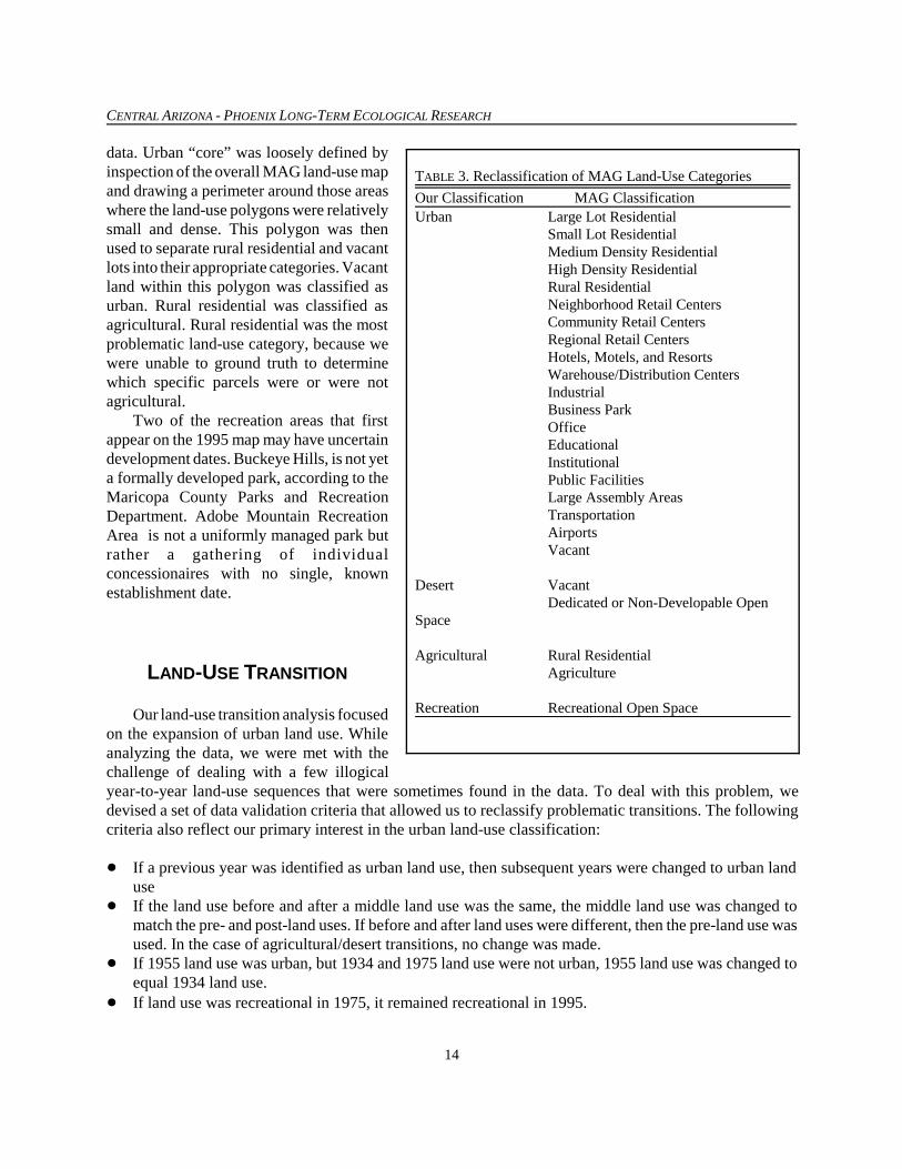
data. Urban “core” was loosely defined byinspection of the overall MAG land-use mapand drawing a perimeter around those areaswhere the land-use polygons were relativelysmall and dense. This polygon was thenused to separate rural residential and vacantlots into their appropriate categories. Vacantland within this polygon was classified asurban. Rural residential was classified asagricultural. Rural residential was the mostproblematic land-use category, because wewere unable to ground truth to determinewhich specific parcels were or were notagricultural.
Two of the recreation areas that firstappear on the 1995 map may have uncertaindevelopment dates. Buckeye Hills, is not yeta formally developed park, according to theMaricopa County Parks and RecreationDepartment. Adobe Mountain RecreationArea is not a uniformly managed park butrather a gathering of individualconcessionaires with no single, knownestablishment date.
LAND-USE TRANSITION
Our land-use transition analysis focusedon the expansion of urban land use. Whileanalyzing the data, we were met with thechallenge of dealing with a few illogicalyear-to-year land-use sequences that were sometimes found in the data. To deal with this problem, wedevised a set of data validation criteria that allowed us to reclassify problematic transitions. The followingcriteria also reflect our primary interest in the urban land-use classification:
� If a previous year was identified as urban land use, then subsequent years were changed to urban landuse
� If the land use before and after a middle land use was the same, the middle land use was changed tomatch the pre- and post-land uses. If before and after land uses were different, then the pre-land use wasused. In the case of agricultural/desert transitions, no change was made.
� If 1955 land use was urban, but 1934 and 1975 land use were not urban, 1955 land use was changed toequal 1934 land use.
� If land use was recreational in 1975, it remained recreational in 1995.
TABLE 3. Reclassification of MAG Land-Use Categories
Our Classification MAG ClassificationUrban Large Lot Residential
Small Lot ResidentialMedium Density ResidentialHigh Density ResidentialRural ResidentialNeighborhood Retail CentersCommunity Retail CentersRegional Retail CentersHotels, Motels, and ResortsWarehouse/Distribution CentersIndustrialBusiness ParkOfficeEducationalInstitutionalPublic FacilitiesLarge Assembly AreasTransportationAirportsVacant
Desert Vacant Dedicated or Non-Developable Open
Space
Agricultural Rural ResidentialAgriculture
Recreation Recreational Open Space

REPORT ON GENERALIZED LAND USE
15
Table 4 shows the amount of land affected each year by application of the above criteria. Table 5displays the amount of land per land use and year and explains which land uses gave way to urban land usefor each year studied. Figures 1 and 2 follow the tables and are visualizations of the data in Table 5,demonstrating changes in urban land sources.
TABLE 4. Percent of study area affected by application of data validation criteria.
Year Land-Use Class Pre-Criteria Post-CriteriaPercent Change Due
to Data Validation Criteria1912 Agricultural 9.0% 9.0% 0.0%
Desert 90.9% 90.9% 0.0%Recreation 0.0% 0.0% naUrban 0.2% 0.2% 0.0%Total 100.0% 100.0%
1934 Agricultural 15.7% 15.7% 0.0%Desert 83.4% 83.4% 0.0%Recreation 0.5% 0.5% 0.0%Urban 0.4% 0.4% 2.4%Total 100.0% 100.0%
1955 Agricultural 13.5% 13.8% 2.6%Desert 81.9% 82.3% 0.5%Recreation 1.2% 1.2% 0.0%Urban 3.4% 2.7% -21.5%Total 100.0% 100.0%
1975 Agricultural 16.0% 16.0% 0.0%Desert 74.2% 74.1% -0.1%Recreation 3.3% 3.3% 0.1%Urban 6.5% 6.6% 1.5%Total 100.0% 100.0%
1995 Agricultural 11.4% 11.3% -1.2%Desert 66.7% 66.4% -0.5%Recreation 4.7% 4.4% -6.1%Urban 17.2% 18.0% 4.2%Total 100.0% 100.0%

CENTRAL ARIZONA - PHOENIX LONG-TERM ECOLOGICAL RESEARCH
16
Change in Urban Land SourcesNew Urban Areas Only
0%
2%
4%
6%
8%
10%
12%
1934 1955 1975 1995
Per
cen
t N
ew U
rban
Was Agriculture Was Desert
58.1%
41.9%60.1%
39.9%82.6%
17.4%
98.2%
1.8%
FIG. 1. Change in urban land sources; new urban areas only.
TABLE 5. Land Use per Year (km2)
1912 1934 1955 1975 1995
Total Land Area 11,452 11,452 11,452 11,452 11,452
Total Agricultural Area 1,026 1,792 1,583 1,837 1,293
Total Desert Area 10,406 9,551 9,424 8,486 7,599
Total Recreational Area 0 61 139 378 502
Total Urban Area 20 47 306 751 2,058
Urban from Agricultural 0 27 213 178 547
Urban from Desert 20 0 45 268 760
Urban from Recreational 0 0 0 0 0
Urban from Urban 0 20 48 305 751
Total New Urban Area 0 27 259 445 1,307

REPORT ON GENERALIZED LAND USE
17
Change in Urban Land Sources
0%
2%
4%
6%
8%
10%
12%
14%
16%
18%
20%
1912 1934 1955 1975 1995
Per
cen
t U
rban
From Agriculture From Desert From Urban
36%
37%
27%
40%
36%
24%57%
42%
100%
16%
15%
69%
1%
FIG. 2. Change in urban land sources.
PHASE II PLANNING
Work has begun on Phase II of the Historic Land Use Project. Phase II involves a more in-depth analysisof land use for specific sites, times, and scales; indeed our time frame for completion of this project is open.In Phase I we produced a land-use classification system specific to the needs of CAP LTER and are meetingwith other CAP LTER researchers to determine their requirements. In Phase II we will expand the numberof land-use categories (see Table 6), monitor changing use of every land parcel for 1 km2 according to theoverall LTER extensive sampling strategy.

CENTRAL ARIZONA - PHOENIX LONG-TERM ECOLOGICAL RESEARCH
18
TABLE 6. Land-Use Classes for Phase II (Modified from Anderson et al. 1976, American Planning AssociationResearch Department 1998, Maricopa Association of Governments 1995).
1. Urban or Built-Up LandA. Residential
1. Small Lot (>5 and <=15 dwellingunits per acre)
2. Medium Lot (>2 and <=5 dwellingunits per acre)
3. Large Lot (>1 and <=2 dwelling unitsper acre)
4. Rural (<= 1 dwelling unit per acre) 5. High Density (>15 dwelling units per
acre) B. Non-Residential 1. Institutional (schools, churches,
public facilities, etc.) 2. Commercial (malls, office buildings,
etc.) 3. Industrial (landfill, utility power
stations, etc.) 4. Mining 5. Large Assembly Areas (includes
stadiums, fairgrounds, etc.) C. Graded, under construction2. Open A. Golf Course B. Parks C. Vacant D. Dedicated E. Natural 1. Forest 2. Desert3. Agricultural Land A. Cropland 1. Active Cropland 2. Fallow Cropland B. Pasture 1. Active Pasture 2. Fallow Pasture
C. Orchards D. Feeding Operations E. Horse Ranches F. Other Agricultural4. Water A. Streams, Rivers, Canals B. Lakes C. Reservoirs5. Riparian Zone A. Vegetated B. Un-vegetated6. Transportation A. Highway B. Major Roads C. Streets D. Airport E. Railroad
Note: Ambiguous uses default to more generallevel category
REPORT ON GENERALIZED LAND USE
19
LITERATURE CITED
American Planning Association Research Department. 1998. Land-based classification standards.http://www.planning.org/lbcs/index.html.
Anderson, J. R., E. E. Hardy, J. T. Roach, and R. E. Witmer. 1976. A land use and land cover classificationsystem with remote sensor data. U.S. Government Printing Office, Washington, D.C.
Arizona Department of Economic Security. 1997. Special census of Maricopa County, Arizona; census dateOctober 27, 1995. Table 1. Basic counts of population and housing by geographic area. ArizonaDepartment of Economic Security, Arizona State Data Center, Site Code 045Z. Phoenix.
Arizona Department of Economic Security, Research Administration. Historical census data: 1860-1990.“Decennial census population of Arizona, counties, cities, places: 1860 to 1990” [online]. 5 May 1999.[cited 13 May 1999; 15:17 MST]. Available from: http://www.de.state.az.us/links/economic/popweb/decennials.html.
City of Phoenix, Planning Department, Planning Research Section. 1992. Phoenix, a community profile1990. City of Phoenix Planning Department, Phoenix, Arizona, USA.
City of Phoenix, Planning Department, Research Team. 1995 Special census of Maricopa County, Arizona.Planning Department data summary sheet [online]. (Source: Marvin D. Raines, Associate Director ofField Operations, Bureau of the Census, letter 21 May 1996.) 5 February 1997. [cited 15 April 1999;10:30 MST]. Available from: http://www.ci.phoenix.az.us/PLANZONE/ds199605.html.
City of Tempe, Special Projects Division. 1997. 1997 Statistical report. City of Tempe DevelopmentServices, Tempe, Arizona, USA.
City of Tempe. City of Tempe statistics [online]. [cited 22 April 1999; 9:18 MST]. Available from:http://www.tempe.gov/citymgr/stats.htm.
Greater Phoenix Economic Council. 1997. Greater Phoenix by the numbers. Prepared by Elliott D. Pollack& Company. Greater Phoenix Economic Council, Phoenix, Arizona, USA.
Greater Phoenix Economic Council. Greater Phoenix fact book [online]. 1998 [cited 22 April 1999; 13:11MST]. Available from: http://www.gpec.org/marketplace/factbook.html.
Konig, M. F. 1983. Toward metropolis status: Charter government and the rise of Phoenix, Arizona. Ph.D.Thesis, Arizona State University, Tempe.
Kotlanger, M. J. 1983. Phoenix, Arizona: 1920-1940. Ph.D. Dissertation, Arizona State University, Tempe.Maricopa Association of Governments. 1993. Update of the population and socioeconomic database for
Maricopa County, Arizona. Maricopa Association of Governments, Phoenix, Arizona, USA.Maricopa Association of Governments. 1995. 1995 Land use. Maricopa Association of Governments,
Phoenix, AZ. Maricopa Association of Governments. 1998. Urban Atlas: Phoenix metropolitan area. Prepared by BRW,
Inc. Maricopa Association of Governments, Phoenix, Arizona, USA.Maricopa County Infrastructure Planning Department. 1994. Maricopa County profile 1994. Maricopa
County, Arizona, USA.Maricopa County Comprehensive Plan. 1995. Maricopa County 2020: Eye to the future. Economic
development element, background and analysis report, 1995-2020. Maricopa County, Arizona, USA.Maricopa County Comprehensive Plan. 1996. Maricopa County 2020: Eye to the future. Land use element,
inventory and analysis report 1996. Maricopa County, Arizona, USA.Maricopa County Planning and Zoning Department. 1964. A part of the comprehensive plan for Maricopa
County, Arizona. Part II: Population, community growth, existing land use. Maricopa County Planningand Zoning Department, printed by Acme Blueprint and Photo-Craft Company, Phoenix, Arizona, USA.

CENTRAL ARIZONA - PHOENIX LONG-TERM ECOLOGICAL RESEARCH
20
Mawn, G. P. 1979. Phoenix, Arizona, central city of the Southwest, 1870-1920. Thesis, Arizona StateUniversity, Tempe.
Maricopa County. 1994. Maricopa County – 2020 eye to the future; economic development element;background and analysis report 1995-2020. Maricopa County, Phoenix, Arizona.
Maricopa County Department of Planning and Development. 1984. Maricopa County demographic atlas.January, Maricopa County Department of Planning and Development, Advance Planning Division,Phoenix, Arizona.
Maricopa County Planning and Zoning Department. 1964. Part II – A part of the comprehensive plan forMaricopa County: Population, community growth, existing land use. Maricopa County Planning andZoning Department, Phoenix, Arizona.
Maricopa County Planning Department. 1975. A report upon future general land use for Maricopa County.February. Maricopa County Planning Department, Phoenix, Arizona.
Preisler, D. 1992. Phoenix, Arizona, during the 1940s: A decade of change. M.A. Thesis, Arizona StateUniversity, Tempe.
U.S. Bureau of the Census. 1896. Abstract of the eleventh census: 1890. Second edition, revised andenlarged. U.S. Government Printing Office, Washington, D.C., USA.
U.S. Bureau of the Census. 1904. Abstract of the twelfth census of the United States: 1900. U.S. GovernmentPrinting Office, Washington, D.C., USA.
U.S. Bureau of the Census. 1913. Thirteenth census of the United States taken in the year 1910: Abstract ofthe census. U.S. Government Printing Office, Washington, D.C., USA.
U.S. Bureau of the Census. 1923. Abstract of the fourteenth census of the United States: 1920. U.S.Government Printing Office, Washington, D.C., USA.
U.S. Bureau of the Census. 1932. Fifteenth census of the United States: 1930. Population, Volume III, Part 1,Alabama-Missouri. U.S. Government Printing Office, Washington, D.C., USA.
U.S. Bureau of the Census. 1942. Sixteenth census of the United States: 1940. Population, Volume I:Number of inhabitants. U.S. Government Printing Office, Washington, D.C., USA.
U.S. Bureau of the Census. 1952. Census of population: 1950. Volume II: Characteristics of the population,Part 3: Arizona. U.S. Government Printing Office, Washington, D.C., USA.
U.S. Bureau of the Census. 1960. U.S. Census of population: 1960. Number of inhabitants, Arizona. FinalReport PC(1)–4A. U.S. Government Printing Office, Washington, D.C., USA.
U.S. Bureau of the Census. 1973. 1970 Census of population. Volume I: Characteristics of the population,Part 4: Arizona. U.S. Government Printing Office, Washington, D.C., USA.
U.S. Bureau of the Census. 1982. 1980 Census of population. Volume 1: Characteristics of the population,Chapter A: Number of inhabitants, Part 4: Arizona, PC80-1-A4. U.S. Government Printing Office,Washington, D.C., USA.
U.S. Bureau of the Census. 1993. 1990 Census of population and housing. Population and housing unitcounts: Arizona. 1990 CPH-2-4. U.S. Government Printing Office, Washington, D.C., USA.
U.S. Bureau of the Census. USA Counties 1996, Geographic Area: Maricopa, AZ (04013), Table: GeneralProfile, Population and Housing [online]. Data from: USA Counties 1996 CD-ROM. 31 October 1996.[cited 23 March 1999; 11:06 MST]. Available from: http://www.census.gov/statab/USA96/04/013.txt.
U.S. Bureau of the Census. Population Estimates Program, Statistical Information Staff, Population Division.SU-96-10 Estimates of the Population of Cities with Populations of 100,000 and Greater (Ranked by1996 Population Size in U.S.): July 1, 1996 (includes revised April 1, 1990 census population counts)[online]. Internet release date: 18 November 1997. [cited 13 May 1999; 13:50 MST]. Available from:http://www.census.gov/population/estimates/metro-city/SC100K96.txt.

REPORT ON GENERALIZED LAND USE
21
HOW TO OBTAIN DATA AND COPIES OF THIS REPORT
Electronic copies of this publication are available at our web site at http://caplter.asu.edu as .pdf filesin both color and black-and-white versions. Data and metadata are also available from our web site at asimages (*.tif), ArcView shapefiles (*.shp), and Arc/Info export files (*.e00). If you have any questions aboutthe web site, please contact the CAP LTER data manager at [email protected]. The shapefiles andArcInfo export files are in UTM, zone 12, meters, datum NAD27. For additional information contact:
Historic Land Use ProjectCAP LTER E-mail: [email protected] for Environmental Studies Phone: (480) 965-2975Arizona State University Fax: (480) 965-8087PO Box 873211Tempe, AZ 85287-3211
LIST OF CONTRIBUTIONS
No. 1. Historic Land Use: Phase I Report on Generalized Land Use. Authors: Kim Knowles-Yánez, CherieMoritz, Jana Fry, Charles L. Redman, Matt Bucchin, and Peter H. McCartney. August 1999.