Site Steward Handbook - New Mexico Historic Preservation ...
Upload
phungnguyetCategory
view
217download
0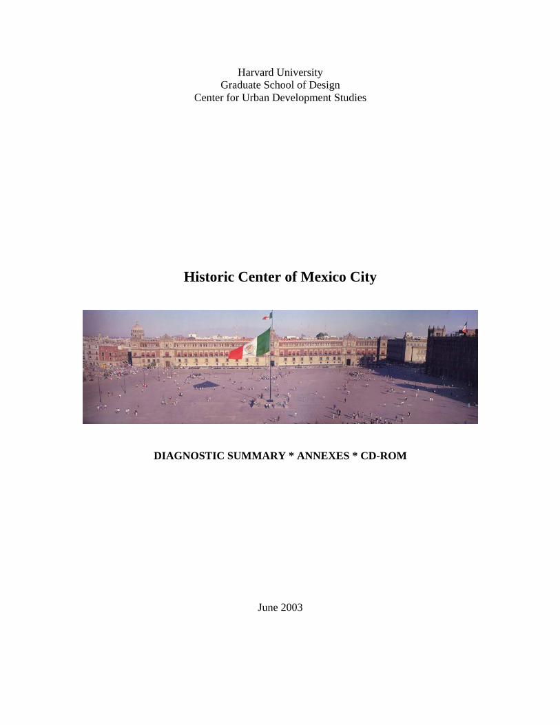
Harvard University Graduate School of Design
Center for Urban Development Studies
Historic Center of Mexico City
DIAGNOSTIC SUMMARY * ANNEXES * CD-ROM
June 2003
STUDY TEAM
François Vigier, Director Liz Meléndez San Miguel, Research Associate Luis Valenzuela, Research Assistant Elda Solloso, Research Assistant
The Center for Urban Development Studies’ research on the Historic Center of Mexico City was prepared with financial support from the Historic Center Foundation and was undertaken in collaboration with:
Adrian Pandal, Director, Historic Center Foundation Enrique Martín Moreno, Research Affiliate
Front Cover Image: World Heritage in Mexico. Fondo Editorial de la Plastica Mexicana, Mexico D.F., 1998.
Historic Center Mexico City Harvard University Center for Urban Development Studies
1
DEVELOPING A COMPREHENSIVE STRATEGY 2
HISTORICAL SUMMARY 10
GOVERNMENT STRUCTURES 15
FEDERAL DISTRICT OF MEXICO CITY 15 CUAUTÉHMOC DELEGATION 21 VENUSTIANO CARRANZA DELEGATION 22 OTHER GOVERNMENTAL INSTITUTIONS AND NONGOVERNMENTAL ORGANIZATIONS 23
PLANS AND PROGRAMS 26
KEY ISSUES IN THE DEVELOPMENT OF THE HISTORIC CENTER 28
REGIONAL ISSUES – FEDERAL DISTRICT 28 INTERMEDIATE ISSUES – CUAUTÉHMOC AND VENUSTIANO CARRANZA 30 LOCAL ISSUES – HISTORIC CENTER 30
ENDNOTES 39
ANNEXES 40
ANNEX I: NUMERICAL DATA 41 CENSUS DATA 41 ECONOMIC AND EMPLOYMENT DATA 46 TRANSPORT DATA 46 OTHER RELEVANT DATA ON THE HISTORIC CENTER 47
ANNEX II: NONGOVERNMENTAL ORGANIZATIONS 48 ANNEX III: LAND USE MAPS 51
REFERENCES 55
CD-ROM Back Cover
Historic Center Mexico City Harvard University Center for Urban Development Studies
2
Developing a Comprehensive Strategy Background As Mexico City continues to grow, the social and economic issues facing planners and city officials will become increasingly complex to negotiate and resolve. For those working to rehabilitate the Historic Center, the greatest challenge is the elaboration of a comprehensive development strategy that will promote local growth objectives in light of its physical, social, political and economic characteristics. A strategy to re-establish the Center’s position in the mega-city needs to address its changing role and the multiple concerns and objectives of the Center’s residents and its business and commercial community. The preservation and rehabilitation of the area can only be conceived within the broader context of factors that have affected the area, transforming its economic base and contributing to the progressive deterioration of its social and built environment:
• The massive loss of residents experienced between 1970 and 1995; • The relocation of important business and cultural activities traditionally housed
in the area to new suburban nodes of development; • The consequent deterioration of the built environment, also due to
disinvestments and absentee owners; • The loss of employment in the formal sector that fostered the rapid development
of the informal commercial sector; • A drastic reduction in housing availability as buildings were rapidly being
transformed into commercial, warehouse and business uses; • An increase in lower income and socially vulnerable groups living in unsanitary
conditions and high-risk housing; • An increase in vehicular traffic, in part due to inadequate public transportation
and; • The rapid deterioration of the historic fabric.
A Comprehensive Strategy Throughout the decade of the 90’s numerous institutions were created and plans developed to foster a process of recuperation for the area. The Strategic Plan for the Regeneration and Integral Development of the Historic Center, prepared by the Historic Center Trusteeship was an integrated plan based on four strategies targeted to respond to the core issues that affect the area through: (a) the reestablishment of centrality; (b) the regeneration of housing; (c) economic development and; (d) social development. Although these strategies and their corresponding lines of action presented a strong comprehensive approach, the plan lacked institutional continuity due to the reorganization of the Trusteeship, and supporting programs and projects were never implemented.
Nevertheless, the strategies and lines of action presented in the plan are still relevant to the current situation of the Historic Center and could very well serve as the basis for a
Historic Center Mexico City Harvard University Center for Urban Development Studies
3
development strategy for the area. A comprehensive strategy however, needs to focus not only on the identification of the core issues upon which the sustainable and continued growth and development of the area can be based but also on the development of economically and financially feasible projects and programs that can ensure its success by: • Promoting the development of the sectors that can give the Historic Center a
competitive advantage over other commercial, business and residential centers in the City;
• Creating a favorable environment for business and commercial development, offering transparent incentives to attract private investors;
• Providing the infrastructure needed to promote and sustain growth in the area while considering alternative ways of dealing with the precarious nature of the site;
• Developing a land management strategy that can respond effectively to the dynamics of development within the broader urban agglomeration;
• Developing an appropriate housing strategy to respond effectively to the current needs of the community as well as the demand for new housing;
• Defining an institutional structure and regulatory framework that can deal comprehensively and effectively with the specific issues that affect the Historic Center as a whole - Perimeters “A” and “B” - by supporting and coordinating the actions of the two delegations with jurisdiction, Cuautéhmoc and Venustiano Carranza;
• Identifying the roles and responsibilities of stakeholders in the implementation of the strategies;
• Developing a participatory program that will promote community involvement in the development of strategies, programs and actions, keeping the residents and businesses involved in the decision making process;
• Recommending priority interventions to be undertaken and; • Developing appropriate indicators to measure the effectiveness of these
interventions and their impact on the community.
Planning Framework The challenges faced in the rehabilitation of the Historic Center are not unique; however, the magnitude of the issues is compounded by the size of the area, the exceedingly rapid growth of Mexico City and the precarious nature of the site. Pragmatic approaches and flexible mechanisms are needed to create opportunities for the development of growth sectors capable of driving the area’s economy, in order to attract new investment and ensure that the benefits of growth are equitably distributed. A planning framework based on instruments such as those presented below can be used in the formulation of a strategy and an action plan for the preservation and revitalization of the Historic Center:
1. Development of a strategy for the revitalization and preservation of the Historic Center A priority when formulating an operational strategy for the revitalization of the
Historic Center Mexico City Harvard University Center for Urban Development Studies
4
Historic Center is to ensure its integration and coordination with the current plans, projects and programs organized and managed by the different levels of governments and NGOs. Integration is imperative in order to coordinate proposals and avoid conflicting actions among the different parties involved. Reaching a broad consensus among all parties at the federal, district, delegation and community levels is critical in ensuring the implementation of the strategy and in reestablishing the position of the district within its context. Therefore the new plan shall focus not only on the Historic core itself but also on the surrounding impact zone and the major links to other important development nodes in the city. An effective revitalization strategy will result in greater benefits from current investments in infrastructure and housing, opening up new employment opportunities in the area.
2. Development of a master plan for Perimeters “A” and “B” A significant step in the revitalization of the area is the preparation and implementation of a spatial development plan that stems from the revitalization strategy and reexamines and redefines the existing perimeters for action. Specific intervention strategies and the establishment of strategic nodes for action shall recognize and attend to the development of incentives necessary to attract private investment.
3. Focusing on infrastructure, safety and public space to be the catalysts for upgrading and revitalizing the built environment Public investment in infrastructure, safety and public space act as incentives to foster private investment in the process of revitalization of the degraded built environment. Projects like the current infrastructure and façade improvements led by the Trusteeship foster and encourage private investment initiatives in housing, office and commercial buildings. The development of infrastructure projects in the area needs to be comprehensively linked to the spatial development plan and the strategic nodes identified as catalysts in the recuperation process.
4. Devising a concise regulatory framework for new construction and the rehabilitation of existing structures A critical objective of a concise regulatory framework is to develop simple and effective controls that local authorities are able and willing to enforce. The effectiveness of these regulations is reinforced by their integration in an operational strategy framework as well as their articulation within the spatial development plan.

Historic Center Mexico City Harvard University Center for Urban Development Studies
5
5. Capitalize on development opportunities in strategically located parcels to launch the revitalization process Buildings and land in public ownership and strategically located sites offer opportunities to introduce projects that act as catalysts in reversing the dynamics leading to deterioration and loss of older buildings. They can also become a revenue source for the local authorities.
A Sectoral Approach Using as a basis the strategic outline developed by the Trusteeship it is possible to consider a sectoral approach that takes into account the local and regional dynamics affecting the Historic Center. This approach requires extensive documentation and analysis of the fundamental determinants of change and transformation of the area however, we propose a simple outline of possible objectives based on background material collected, interviews and the proposed strategies outlined in the Strategic Plan for the Regeneration and Integral Development of the Historic Center. 1. Re-establish the role of the Historic Center The issue of centrality and the role of the historic center within the context of the mega-city are fundamental to its revitalization, sustainability and future development. In order to achieve this goal it is not only important to consider issues of access and recuperation of the area, but also to foster private investment and the insertion of new uses that can operate as catalysts for new developments, housing and employment.
Actions • Develop a comprehensive vision for the Historic Center that leads action
programs and prioritizes investment opportunities by identifying the sectors that can give the Historic Center a competitive advantage over other commercial, business and residential centers in the City.
• Focus public investment in infrastructure, safety and the revitalization of the urban image, particularly the recuperation of public space.
• Address major corridors leading to and from the Center to ensure its integration to the City, improve accessibility and foster development opportunities.
Map shows major roadways leading to the Historic core of the city (1858 growth shown in red). The areas of Roma and Condesa, which have seen major recuperation in the past decade and are a competing center for residential uses are highlighted in yellow. Adapted from Map 2.5.3: Expansion of Mexico City 1858-1910 and Map 5.4.2: Primary Roads from La Ciudad de Mexico en el fin del segundo milenio.
Historic Center Mexico City Harvard University Center for Urban Development Studies
6
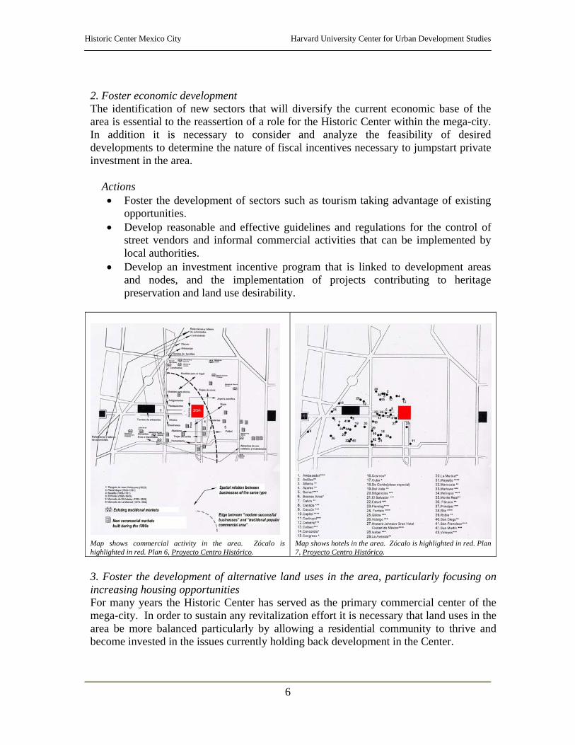
2. Foster economic development The identification of new sectors that will diversify the current economic base of the area is essential to the reassertion of a role for the Historic Center within the mega-city. In addition it is necessary to consider and analyze the feasibility of desired developments to determine the nature of fiscal incentives necessary to jumpstart private investment in the area.
Actions • Foster the development of sectors such as tourism taking advantage of existing
opportunities. • Develop reasonable and effective guidelines and regulations for the control of
street vendors and informal commercial activities that can be implemented by local authorities.
• Develop an investment incentive program that is linked to development areas and nodes, and the implementation of projects contributing to heritage preservation and land use desirability.
Map shows commercial activity in the area. Zócalo is highlighted in red. Plan 6, Proyecto Centro Histórico.
Map shows hotels in the area. Zócalo is highlighted in red. Plan 7, Proyecto Centro Histórico.
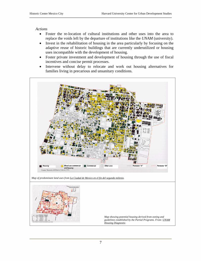
3. Foster the development of alternative land uses in the area, particularly focusing on increasing housing opportunities For many years the Historic Center has served as the primary commercial center of the mega-city. In order to sustain any revitalization effort it is necessary that land uses in the area be more balanced particularly by allowing a residential community to thrive and become invested in the issues currently holding back development in the Center.
Historic Center Mexico City Harvard University Center for Urban Development Studies
7
Actions • Foster the re-location of cultural institutions and other uses into the area to
replace the voids left by the departure of institutions like the UNAM (university). • Invest in the rehabilitation of housing in the area particularly by focusing on the
adaptive reuse of historic buildings that are currently underutilized or housing uses incompatible with the development of housing.
• Foster private investment and development of housing through the use of fiscal incentives and concise permit processes.
• Intervene without delay to relocate and work out housing alternatives for families living in precarious and unsanitary conditions.
Map of predominant land uses from La Ciudad de Mexico en el fin del segundo milenio.
Map showing potential housing derived from zoning and guidelines established by the Partial Programs. From: UNAM Housing Diagnostic.
Historic Center Mexico City Harvard University Center for Urban Development Studies
8
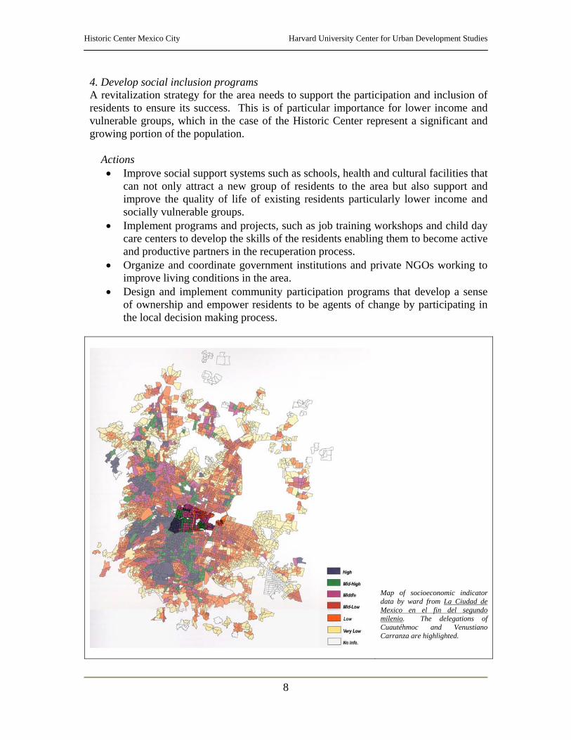
4. Develop social inclusion programs A revitalization strategy for the area needs to support the participation and inclusion of residents to ensure its success. This is of particular importance for lower income and vulnerable groups, which in the case of the Historic Center represent a significant and growing portion of the population.
Actions • Improve social support systems such as schools, health and cultural facilities that
can not only attract a new group of residents to the area but also support and improve the quality of life of existing residents particularly lower income and socially vulnerable groups.
• Implement programs and projects, such as job training workshops and child day care centers to develop the skills of the residents enabling them to become active and productive partners in the recuperation process.
• Organize and coordinate government institutions and private NGOs working to improve living conditions in the area.
• Design and implement community participation programs that develop a sense of ownership and empower residents to be agents of change by participating in the local decision making process.
Map of socioeconomic indicator data by ward from La Ciudad de Mexico en el fin del segundo milenio. The delegations of Cuautéhmoc and Venustiano Carranza are highlighted.
Historic Center Mexico City Harvard University Center for Urban Development Studies
9
5. Coordinate and consolidate institutional activities and regulatory frameworks Consolidating institutional activities and developing concise and effective regulatory frameworks is fundamental to the success and implementation of programs and projects thus minimizing institutional overlap. It is particularly important to make information available and accessible to residents, private investors and other stakeholders so that they may become active and effective participants of the recuperation process.
Actions • Devise, implement and enforce a concise and feasible regulatory framework that
is in tune not only with the requirements necessary to preserve and develop a historic district but also with a coordinated development strategy and sensitive to the pressures of private investors.
• Consolidate institutional activities by designating or creating a single institution that has the capacity and authority to coordinate and implement regulatory frameworks, spatial development plans and economic and social development projects and programs.
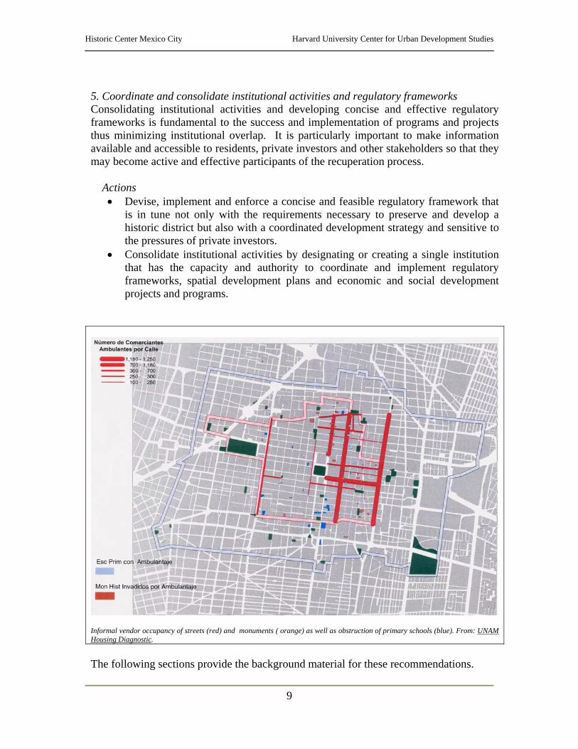
Informal vendor occupancy of streets (red) and monuments ( orange) as well as obstruction of primary schools (blue). From: UNAM Housing Diagnostic.
The following sections provide the background material for these recommendations.
Historic Center Mexico City Harvard University Center for Urban Development Studies
10
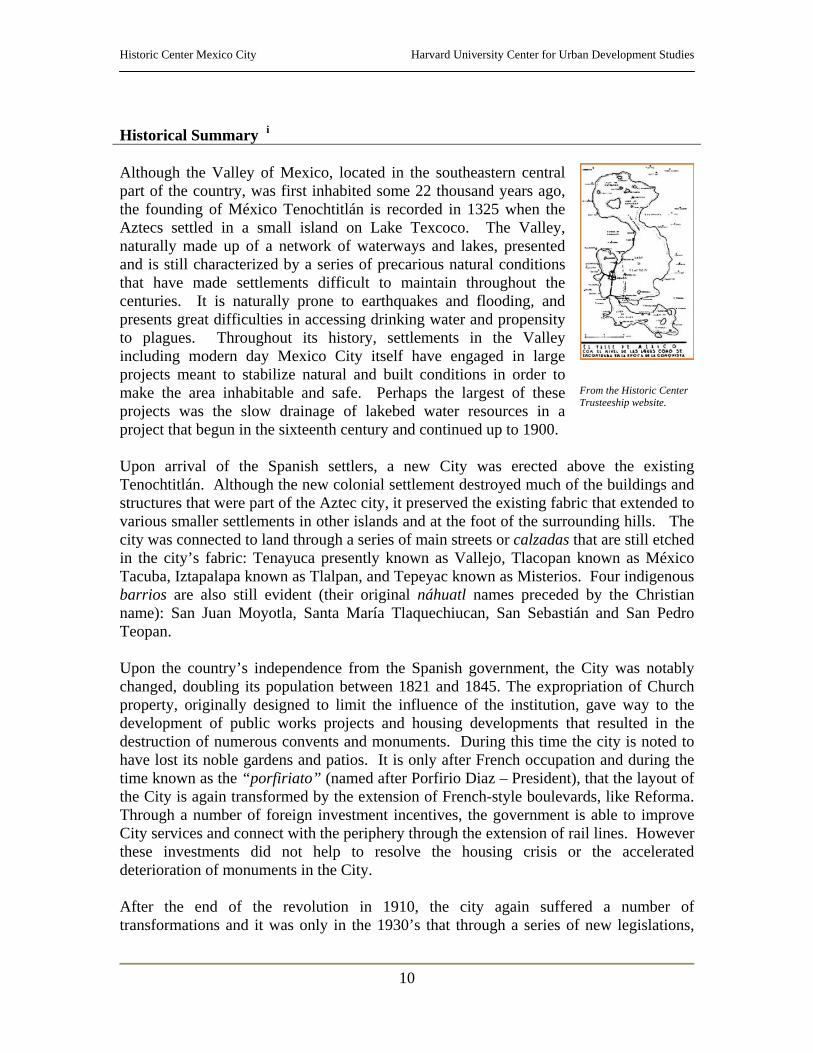
Historical Summary i Although the Valley of Mexico, located in the southeastern central part of the country, was first inhabited some 22 thousand years ago, the founding of México Tenochtitlán is recorded in 1325 when the Aztecs settled in a small island on Lake Texcoco. The Valley, naturally made up of a network of waterways and lakes, presented and is still characterized by a series of precarious natural conditions that have made settlements difficult to maintain throughout the centuries. It is naturally prone to earthquakes and flooding, and presents great difficulties in accessing drinking water and propensity to plagues. Throughout its history, settlements in the Valley including modern day Mexico City itself have engaged in large projects meant to stabilize natural and built conditions in order to make the area inhabitable and safe. Perhaps the largest of these projects was the slow drainage of lakebed water resources in a project that begun in the sixteenth century and continued up to 1900.
From the Historic Center Trusteeship website.
Upon arrival of the Spanish settlers, a new City was erected above the existing Tenochtitlán. Although the new colonial settlement destroyed much of the buildings and structures that were part of the Aztec city, it preserved the existing fabric that extended to various smaller settlements in other islands and at the foot of the surrounding hills. The city was connected to land through a series of main streets or calzadas that are still etched in the city’s fabric: Tenayuca presently known as Vallejo, Tlacopan known as México Tacuba, Iztapalapa known as Tlalpan, and Tepeyac known as Misterios. Four indigenous barrios are also still evident (their original náhuatl names preceded by the Christian name): San Juan Moyotla, Santa María Tlaquechiucan, San Sebastián and San Pedro Teopan. Upon the country’s independence from the Spanish government, the City was notably changed, doubling its population between 1821 and 1845. The expropriation of Church property, originally designed to limit the influence of the institution, gave way to the development of public works projects and housing developments that resulted in the destruction of numerous convents and monuments. During this time the city is noted to have lost its noble gardens and patios. It is only after French occupation and during the time known as the “porfiriato” (named after Porfirio Diaz – President), that the layout of the City is again transformed by the extension of French-style boulevards, like Reforma. Through a number of foreign investment incentives, the government is able to improve City services and connect with the periphery through the extension of rail lines. However these investments did not help to resolve the housing crisis or the accelerated deterioration of monuments in the City. After the end of the revolution in 1910, the city again suffered a number of transformations and it was only in the 1930’s that through a series of new legislations,
Historic Center Mexico City Harvard University Center for Urban Development Studies
11
certain areas of the historic city were protected such as Zócalo, Moneda St. and various other predominant buildings. At this time the city was also recognized to be the city of greatest cultural importance in the American continent. These early decrees for protection revealed the growing concern over the continual decline of the city’s urban structure and its uncontrolled growth. The city, which at the time of independence had 130,000 inhabitants, had grown to 1.230 million inhabitants by 1930. In 1934, the National Institute for Anthropology and History catalogued 768 monuments, of which 422 were demolished that same year. At that time the city hosted a variety of uses ranging from public administrative offices, to the National University of Mexico (UNAM), a financial center, private offices, and mayor businesses. These uses slowly encroached upon the residential areas of the city, which were slowly being occupied by rural immigrants, and its traditional residential population began moving towards new developments in Guerrero, Nueva Santa María, San Rafael, Juárez and San Miguel Tacubaya. During the 1940’s rent control was established as an emergency measure and has remained place for over 50 years. Rent control, together with the migration of residents of the Historic Center toward new development nodes, resulted in the rapid expansion of the city and the residential abandonment of the area. Commercial and retail uses began prevailing in the area and are the primary uses still today, although, primary financial institutions have also left. In 1954, the UNAM left the city for a new university district – Ciudad Universitaria. During the decade of 1950 to 1960, new roads were built to respond to the growing traffic concerns, such as avenues 20 de Noviembre and San Juan de Letrán. These new access roads would soon be home to new private investments that would eventually result in the displacement of the major financial uses that were located in the traditional center. The displacement of these major uses resulted in the continual loss of population in the area, the slow deterioration of the physical and social environment of the neighborhoods of the center and the dislodgment of the Historic Center as the central node of the City. In 1968, the metro opened its first lines with the hope of alleviating growth and concentrating development in certain areas. However, the city continued growing at an alarming rate, particularly in 1979 and 1980, forcing the development of a new highway system linking new developments to the historic center and the traditional urban fabric. In April of 1980, as a direct consequence of the rehabilitation of the Templo Mayor, federal legislation was developed recognizing and safeguarding the historic center as “Historical Monument Zone”. The legislation defined an area of 668 blocks, 9.1 square kilometers (of the 600 sq. km. of the City) and delineated it within two perimeters: “A”(3.2 sq.km.), which covered much of the colonial city and monuments, and “B”(5.9 sq.km.), which acted as a buffer zone. The legislation recognized the existence of: 67 religious monuments, 129 civil monuments, 542 buildings included by an earlier legislation in 1972, 743 valuable buildings to be conserved, 111 environmentally

Historic Center Mexico City Harvard University Center for Urban Development Studies
12
valuable buildings to be conserved, 6 modern temples, 17 buildings linked to historical events or people, 78 plazas and gardens, 19 cloisters, 26 fountains or commemorative monuments, 13 museums or galleries, and 23 sites or buildings with mural paintings. In December of 1987, UNESCO declared the Historic Center a World Heritage Site. With the designation of the Center, came great interest in revitalizing the area and balancing land uses to promote the return of a residential population to the Center. Tragically these projects came to a halt when, in September 1985, the City was struck by devastating earthquakes that took the lives of over 10,000 residents and caused damage to hundreds of buildings. Over 100,000 housing units were lost. One of the areas that was most affected in the city was the Historic Center due to the vulnerability of its dry lakebed foundation. In the aftermath of the disaster numerous projects were developed, in particular to stabilize structures in the area, demolish unstable buildings and rebuild housing units for the new homeless. In 1989, the National Development Plan of 1989-1994 established, as a goal, the recuperation and preservation of the Historic Center, and presented a program for the integral redevelopment of the area. Due to the lack of financial resources, the Delegation created partnership programs with business and nongovernmental organizations in the area. The Delegation would provide the workers, equipment and supervision of works and the businesses of the area would provide the financial resources necessary to cover the costs of construction materials, landscaping and urban furniture. Donations to the government from the businesses were held in accounts by street and each disbursement from the accounts had to be authorized by the Purchasing Committee which included three representatives of the street, one from the Cuautéhmoc Delegation and one from the Historic Center Trusteeship. The government also instituted a number of incentives such as the reduction of real estate depreciation periods from twenty years to ten, that is to say 10% annually rather than the previous 5%. In addition, the Federal District implemented a tax exemption of 100% of the property tax. Taxes over real estate acquisition and fees for the licensing of works and inscription in the public register were also waived for the length of the project. In addition, investors were allowed to transfer development rights to other parts of the city. The rehabilitation program also promoted the relocation of street vendors to 37 new public markets through the Program for the Improvement of Popular Business. In all, the program saw the restoration of over 500 buildings with an estimated investment of over 1 million pesos. Ironically, ten years later, the Center is currently undergoing a similar program, under the coordination of a reorganized Trusteeship. As outlined in the Partial Plan for the Historic Center, the last three decades of abandonment and ineffective investment in the Historic Center have resulted in the physical and social decline of the area. The loss of population has been compounded by the deterioration and eventual loss of culturally significant buildings and sites, the degradation of public space, the severe deterioration of its infrastructure and public
Historic Center Mexico City Harvard University Center for Urban Development Studies
13
services and, increased levels of criminal activity in the area. The lack of a comprehensive economic and social development strategy for the Historic Center has allowed the development of an informal economy that has taken over the public space in the area, resulting in conflicts between the existing residential population, established businesses and, floating populations and street vendors. An important conclusion drawn in the partial plan is that with the exception of the areas of Zócalo and the cultural-tourism corridor (Alameda-Zócalo), public and private investments in the Center have been scarce and have been concentrated along the principal roadways that cross and bound the Historic Center. Rehabilitation programs such as Renovación Habitacional Popular, Fase II and more recently, Casa Propia, and the creation of the Trusteeship for the Historic Center (the original private institution), although important for their contributions, have not been able to revert the social and physical decline of the area, primarily due to their limited institutional capacity and the limited nature of their punctual interventions. ii Although the Historic Center has yet to undergo an enduring renaissance it continues to be an important metropolitan node due to its location, tradition and historical patrimony, economic base, transportation network and the services it provides for the rest of the city. With an estimated population of approximately 100,000 residents (out of the 22 million in the metropolitan area of the City) and a floating population of about 4.2 millioniii, the Historic Center still remains as the area with the largest concentration of commercial and cultural activities in the country.
Historic Center Mexico City Harvard University Center for Urban Development Studies
14
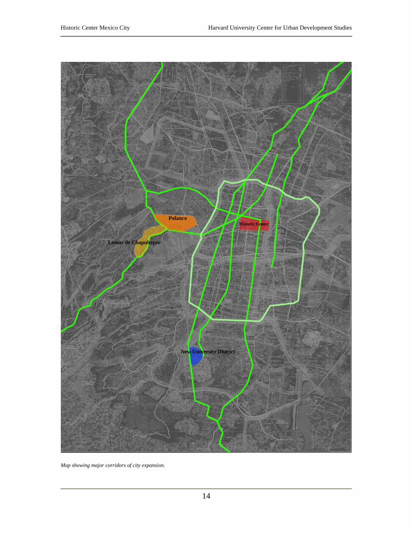
Map showing major corridors of city expansion.
Historic Center Polanco
Lomas de Chapultepec
New University District
Historic Center Mexico City Harvard University Center for Urban Development Studies
15
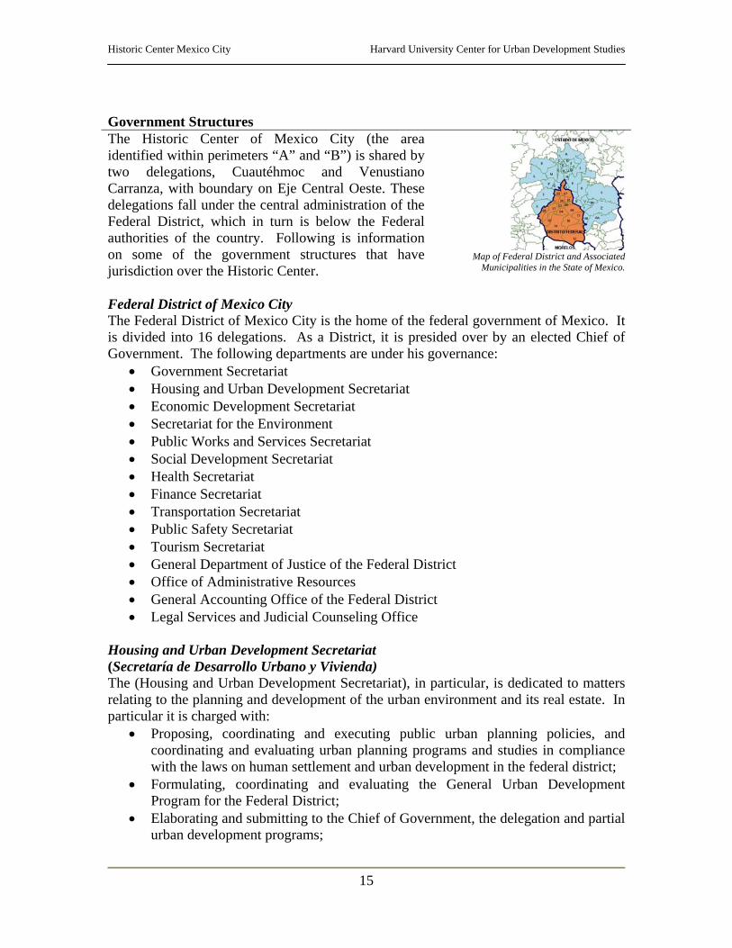
Government Structures The Historic Center of Mexico City (the area identified within perimeters “A” and “B”) is shared by two delegations, Cuautéhmoc and Venustiano Carranza, with boundary on Eje Central Oeste. These delegations fall under the central administration of the Federal District, which in turn is below the Federal authorities of the country. Following is information on some of the government structures that have jurisdiction over the Historic Center.
Map of Federal District and Associated
Municipalities in the State of Mexico.
Federal District of Mexico City The Federal District of Mexico City is the home of the federal government of Mexico. It is divided into 16 delegations. As a District, it is presided over by an elected Chief of Government. The following departments are under his governance:
• Government Secretariat • Housing and Urban Development Secretariat • Economic Development Secretariat • Secretariat for the Environment • Public Works and Services Secretariat • Social Development Secretariat • Health Secretariat • Finance Secretariat • Transportation Secretariat • Public Safety Secretariat • Tourism Secretariat • General Department of Justice of the Federal District • Office of Administrative Resources • General Accounting Office of the Federal District • Legal Services and Judicial Counseling Office
Housing and Urban Development Secretariat (Secretaría de Desarrollo Urbano y Vivienda) The (Housing and Urban Development Secretariat), in particular, is dedicated to matters relating to the planning and development of the urban environment and its real estate. In particular it is charged with:
• Proposing, coordinating and executing public urban planning policies, and coordinating and evaluating urban planning programs and studies in compliance with the laws on human settlement and urban development in the federal district;
• Formulating, coordinating and evaluating the General Urban Development Program for the Federal District;
• Elaborating and submitting to the Chief of Government, the delegation and partial urban development programs;
Historic Center Mexico City Harvard University Center for Urban Development Studies
16
• Intervene as described under the Law for the Urban Development of the Federal District in modifying the General Program, Partial and Delegation Programs;
• Provide technical assistance to the District’s delegations, when necessary, in the execution of programs for urban development;
• Establish policies, strategies, actions and technical systems for urban planning in the District;
• Coordinate the integration of the General Urban Development Program with the Delegation, Partial and Sectoral Programs, update them and evaluate their results;
• Develop urban engineering and architectural projects; • Develop regulations and work with other governmental institutions in public
works of restoration where it is necessary; • Propose and enforce regulations and criteria for permits, authorizations, and
licenses as provided by the Law for the Urban Development of the Federal District, as well as, issues dealing with land use;
• Propose areas to be expropriated through eminent domain; • Study, evaluate and propose areas to be acquired as land reserves for urban
development in short, medium and long term plans; • Develop the technical and administrative mechanisms necessary for urban
development in general; • Promote real estate investment in the public and private sector for housing,
services and the development of programs developed from the General Urban Development Program;
• Coordinate the activities of the institutions dealing with boundaries and names in the Federal District;
• Register and supervise the activities of consultants and directors responsible for public works;
• Authorize and monitor works dealing with the exploitation of natural sand and stone resources; revoke permits when works are not within legal and/or administrative boundaries and rehabilitate mining areas for urban development;
• Formulate, promote and coordinate the development and execution of housing programs in the Federal District and;
• Revise urban impact studies taking into account the directives noted by the Secretariat for the Environment, issuing or revoking land use permits.
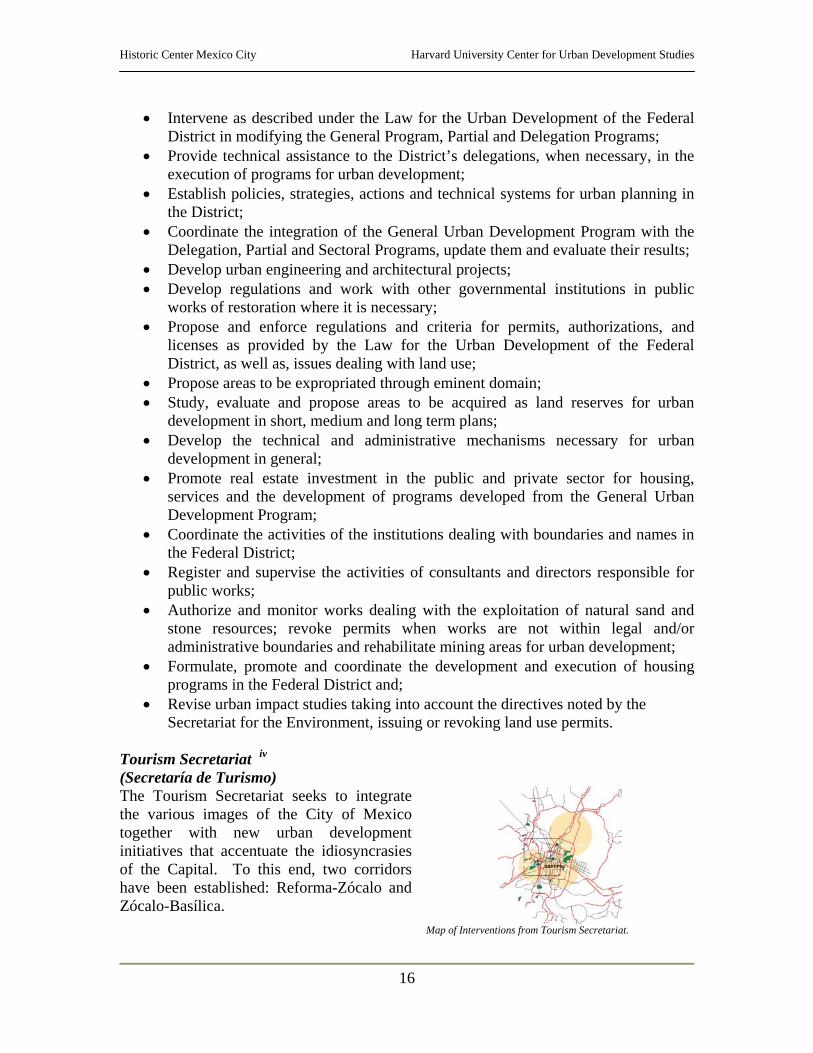
Tourism Secretariat iv (Secretaría de Turismo) The Tourism Secretariat seeks to integrate the various images of the City of Mexico together with new urban development initiatives that accentuate the idiosyncrasies of the Capital. To this end, two corridors have been established: Reforma-Zócalo and Zócalo-Basílica.
Map of Interventions from Tourism Secretariat.
Historic Center Mexico City Harvard University Center for Urban Development Studies
17
The projects are designed to: o Recuperate the urban fabric of the corridor; o Rescue, improve and expand open spaces for pedestrians o Revitalize and rehabilitate urban space; o Foster housing in the area; o Offer incentives for investment and development; Establish an integrated
development planning process; o Offer safety and confidence to citizens and; o Improve infrastructure and services in the area.
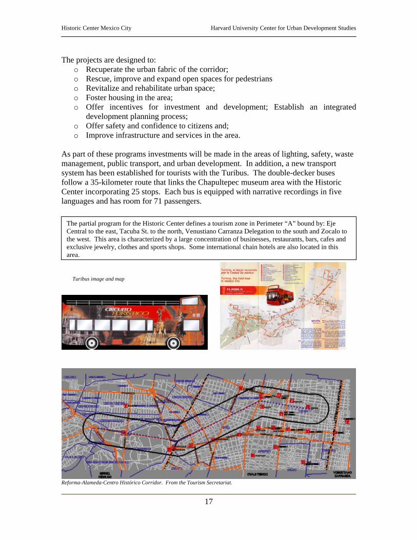
As part of these programs investments will be made in the areas of lighting, safety, waste management, public transport, and urban development. In addition, a new transport system has been established for tourists with the Turibus. The double-decker buses follow a 35-kilometer route that links the Chapultepec museum area with the Historic Center incorporating 25 stops. Each bus is equipped with narrative recordings in five languages and has room for 71 passengers.
Reforma-Alameda-Centro Histórico Corridor. From the Tourism Secretariat.
The partial program for the Historic Center defines a tourism zone in Perimeter “A” bound by: Eje Central to the east, Tacuba St. to the north, Venustiano Carranza Delegation to the south and Zocalo to the west. This area is characterized by a large concentration of businesses, restaurants, bars, cafes and exclusive jewelry, clothes and sports shops. Some international chain hotels are also located in this area.
Turibus image and map
Historic Center Mexico City Harvard University Center for Urban Development Studies
18
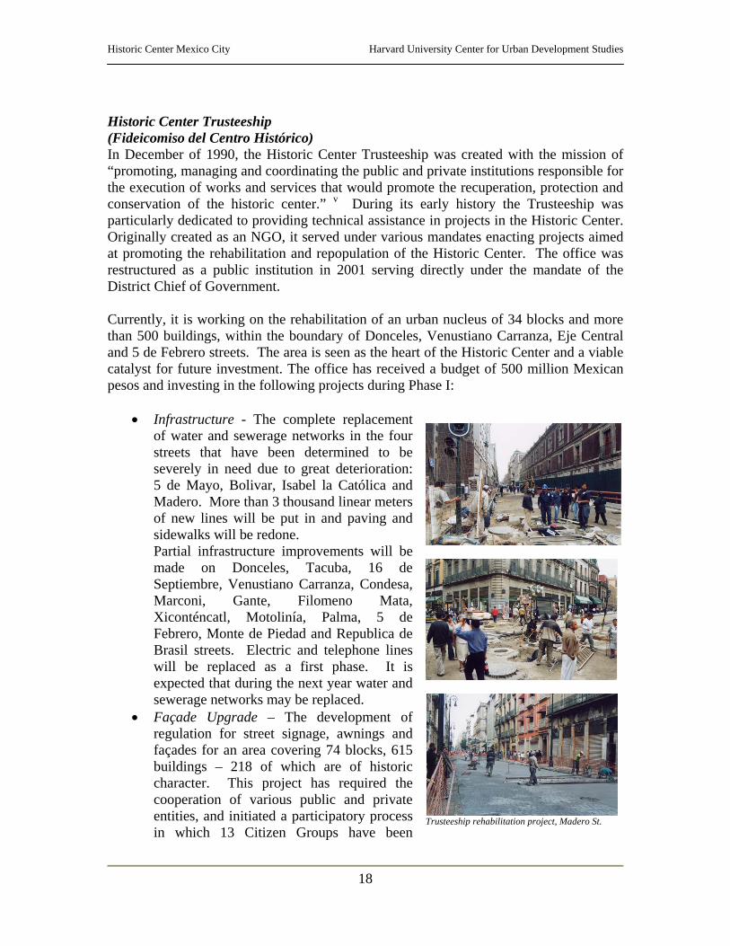
Historic Center Trusteeship (Fideicomiso del Centro Histórico) In December of 1990, the Historic Center Trusteeship was created with the mission of “promoting, managing and coordinating the public and private institutions responsible for the execution of works and services that would promote the recuperation, protection and conservation of the historic center.” v During its early history the Trusteeship was particularly dedicated to providing technical assistance in projects in the Historic Center. Originally created as an NGO, it served under various mandates enacting projects aimed at promoting the rehabilitation and repopulation of the Historic Center. The office was restructured as a public institution in 2001 serving directly under the mandate of the District Chief of Government. Currently, it is working on the rehabilitation of an urban nucleus of 34 blocks and more than 500 buildings, within the boundary of Donceles, Venustiano Carranza, Eje Central and 5 de Febrero streets. The area is seen as the heart of the Historic Center and a viable catalyst for future investment. The office has received a budget of 500 million Mexican pesos and investing in the following projects during Phase I:
• Infrastructure - The complete replacement of water and sewerage networks in the four streets that have been determined to be severely in need due to great deterioration: 5 de Mayo, Bolivar, Isabel la Católica and Madero. More than 3 thousand linear meters of new lines will be put in and paving and sidewalks will be redone. Partial infrastructure improvements will be made on Donceles, Tacuba, 16 de Septiembre, Venustiano Carranza, Condesa, Marconi, Gante, Filomeno Mata, Xiconténcatl, Motolinía, Palma, 5 de Febrero, Monte de Piedad and Republica de Brasil streets. Electric and telephone lines will be replaced as a first phase. It is expected that during the next year water and sewerage networks may be replaced.
• Façade Upgrade – The development of regulation for street signage, awnings and façades for an area covering 74 blocks, 615 buildings – 218 of which are of historic character. This project has required the cooperation of various public and private entities, and initiated a participatory process in which 13 Citizen Groups have been
Trusteeship rehabilitation project, Madero St.

Historic Center Mexico City Harvard University Center for Urban Development Studies
19
created to work with the Trusteeship and eventually acquire ownership of the projects.
• Street Lighting – Existing lighting fixtures will be cleaned and painted, new lighting will be installed where necessary and if possible some historic buildings will be lit at night.
• Urban Furniture – Existing urban furniture will be reduced, replaced and reorganized in the area of the designated 34 blocks to ease pedestrian transit. New signage will be installed in accordance with the new regulations for street signage
Trusteeship rehabilitation project, Madero St.
In addition to the programs limited to the urban nucleus of 34 blocks, the Trusteeship will invest two other areas in the Historic Center:
(a) The rehabilitation of República de Guatemala and Argentina streets as part of a cooperation agreement between the governments of Spain and Mexico. The Spanish government will invest $50,000 USD in the project.
(b) The recuperation of Alameda Central with investments for the improvement of landscaping, paving, urban furniture and illumination. As part of this project, buildings on Independencia, Luis Moya, Dolores streets and Juárez Avenue severely damaged during the 1985 earthquake will be demolished to make room for a new public square, Plaza Juárez. vi
Vendors on Monte de Piedad St.
Plaza on Tacuba St. before and after occupation by squatters
Historic Center Mexico City Harvard University Center for Urban Development Studies
20
The Trusteeship is also coordinating projects with other government agencies such as: • Roadways, transport and parking – Considering that over 350 thousand vehicles
transit through the Historic Center daily and only 125 thousand actually visit the center, the Trusteeship is coordinating with other government agencies to:
o Redesign street flow; o Enforce existing parking regulations particularly against parking on public
ways; o Analyze the existing Project for the Regulation of Cargo Transport in the
Historic Center; o Study the possibility of regularizing the network of public transport in
some of the streets in the Historic Center and; o Considering the current shortage of parking space with only 16,582
parking spaces available in 185 lots, the Trusteeship will study the possibility of locating new parking garages in the Center.
• Street cleaning and trash collection – Considering that 1,452 tons of waste are generated daily in the Historic Center, the Trusteeship:
o Will redesign a system for waste collection that works with the new street flow and;
o Will improve collection and exit efficiency in the area starting with a pilot program to be conducted in the 34 blocks.
• Street vendors – An estimated 30 thousand street vendors operate in the Historic Center on a daily basis. The Sub secretary of Government of the Federal District, the Secretary of Public Safety and the Cuautéhmoc Delegation have established round table talks to deal with the issue of street commerce and hope to work together to limit the number of vendors and the area they occupy in the Historic Center.
• Public Safety – A recuperation program for the Center will be enacted, which requires the increase of security personnel, equipment modernization and efficient communication systems. In addition, a pilot program will be established in Perimeter “A” with the cooperation of the Public Safety Secretariat.
Citizen Participation The Trusteeship is working with the residents and businesses of the urban nucleus in the rehabilitation of the area. Thirteen citizen support groups have been created (one in every street intervened). Each group has selected 2-4 representatives that work together with the Trusteeship in the development, management and maintenance of the projects. A citizen’s Finance Committee is required to verify and sign off on all disbursements and investments made by the Trusteeship. In addition, businesses have been invited to regularize signs and awnings with the design assistance of the Trusteeship. Once the works are finalized, each citizen support group will sign a symbolic agreement in which they become owners and caretakers of the public works.
Historic Center Mexico City Harvard University Center for Urban Development Studies
21
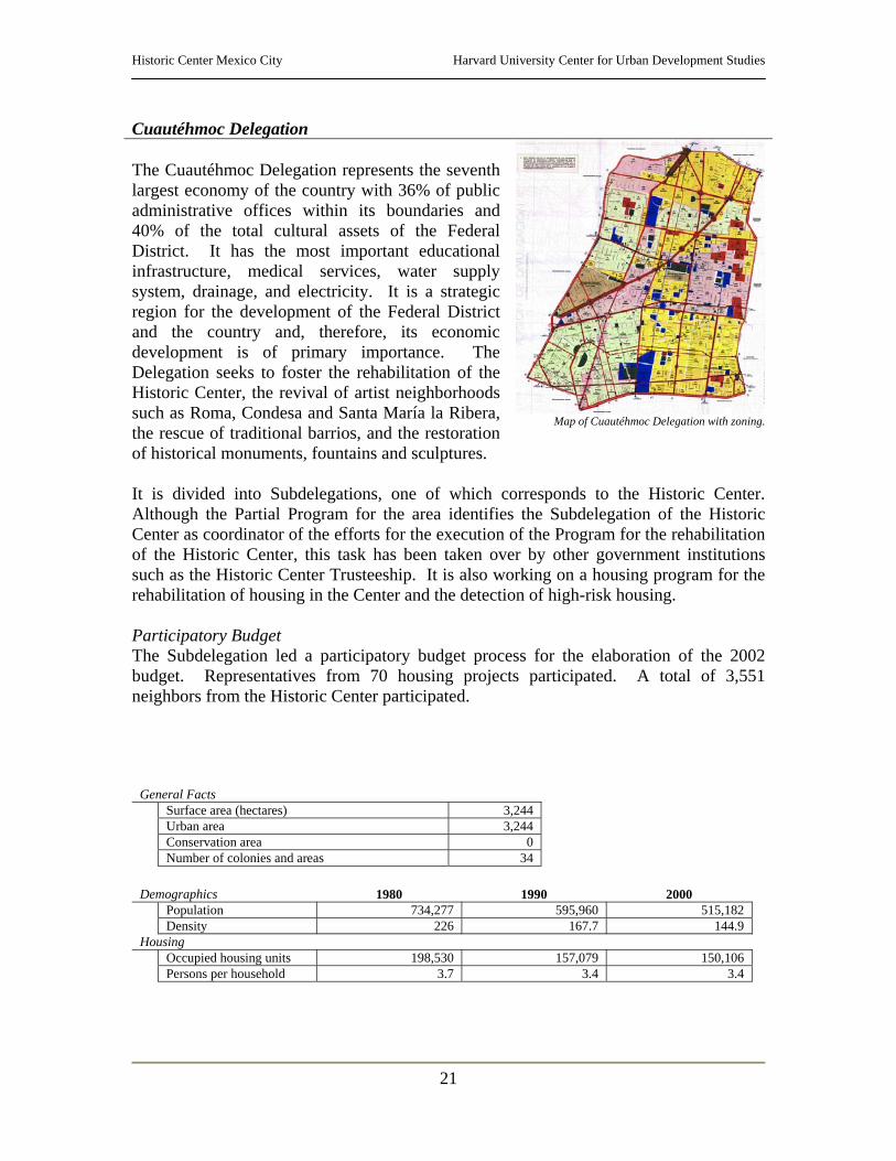
Cuautéhmoc Delegation The Cuautéhmoc Delegation represents the seventh largest economy of the country with 36% of public administrative offices within its boundaries and 40% of the total cultural assets of the Federal District. It has the most important educational infrastructure, medical services, water supply system, drainage, and electricity. It is a strategic region for the development of the Federal District and the country and, therefore, its economic development is of primary importance. The Delegation seeks to foster the rehabilitation of the Historic Center, the revival of artist neighborhoods such as Roma, Condesa and Santa María la Ribera, the rescue of traditional barrios, and the restoration of historical monuments, fountains and sculptures.
Map of Cuautéhmoc Delegation with zoning.
It is divided into Subdelegations, one of which corresponds to the Historic Center. Although the Partial Program for the area identifies the Subdelegation of the Historic Center as coordinator of the efforts for the execution of the Program for the rehabilitation of the Historic Center, this task has been taken over by other government institutions such as the Historic Center Trusteeship. It is also working on a housing program for the rehabilitation of housing in the Center and the detection of high-risk housing. Participatory Budget The Subdelegation led a participatory budget process for the elaboration of the 2002 budget. Representatives from 70 housing projects participated. A total of 3,551 neighbors from the Historic Center participated.
General Facts Surface area (hectares) 3,244 Urban area 3,244 Conservation area 0 Number of colonies and areas 34
Demographics 1980 1990 2000
Population 734,277 595,960 515,182 Density 226 167.7 144.9
Housing Occupied housing units 198,530 157,079 150,106 Persons per household 3.7 3.4 3.4
Historic Center Mexico City Harvard University Center for Urban Development Studies
22
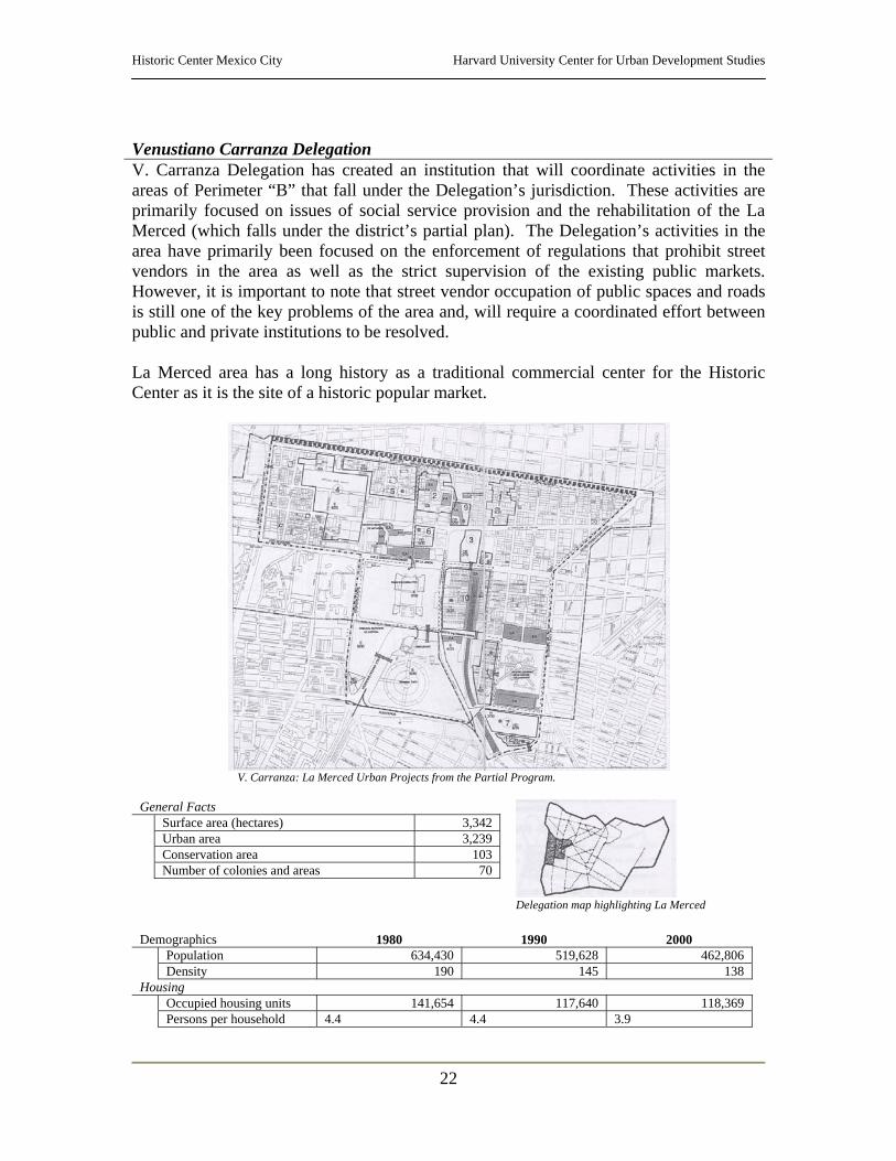
Venustiano Carranza Delegation V. Carranza Delegation has created an institution that will coordinate activities in the areas of Perimeter “B” that fall under the Delegation’s jurisdiction. These activities are primarily focused on issues of social service provision and the rehabilitation of the La Merced (which falls under the district’s partial plan). The Delegation’s activities in the area have primarily been focused on the enforcement of regulations that prohibit street vendors in the area as well as the strict supervision of the existing public markets. However, it is important to note that street vendor occupation of public spaces and roads is still one of the key problems of the area and, will require a coordinated effort between public and private institutions to be resolved. La Merced area has a long history as a traditional commercial center for the Historic Center as it is the site of a historic popular market.
V. Carranza: La Merced Urban Projects from the Partial Program.
General Facts
Surface area (hectares) 3,342 Urban area 3,239 Conservation area 103 Number of colonies and areas 70
Delegation map highlighting La Merced
Demographics 1980 1990 2000 Population 634,430 519,628 462,806 Density 190 145 138
Housing Occupied housing units 141,654 117,640 118,369 Persons per household 4.4 4.4 3.9
Historic Center Mexico City Harvard University Center for Urban Development Studies
23
Other Governmental Institutions and Nongovernmental Organizations Other Government Institutions Involved Many other government institutions at local and national level are responsible for the development of projects and the rehabilitation and conservation of the Historic Center of Mexico City. Of particular importance are:
o National Institute of Archaeology and History - (Instituto Nacional de Arqueología e Historia)– Federal Institution that like the National Council for the Culture and Arts (CONACULTA) is a part of the Public Education Secretariat.
o National Fine Arts Institute – (Instituto Nacional de Bellas Artes)- Federal Institution that, like the National Council for the Culture and Arts (CONACULTA), is a part of the Public Education Secretariat.
⇒ These Institutes are responsible for designing and implementing regulations and programs for
the protection and conservation of the natural heritage at the Federal level. They are the authorities that provide permits for intervention in historic buildings and sites.
Consultative Council for the Rescue of the Historic Center On August 23, 2001, the current Chief of Government of the Federal District created a Consultative Council to watch over the projects and activities related to the rehabilitation and development of the Historic Center. The Council, composed of 130 citizens representing various levels of government and civil society, is headed by an executive committee with representatives from the Federal government, the Federal District and civil society. Members met on a monthly basis to discuss issues of safety, water, infrastructure and façade improvements, and designed a program of tax incentives as well as a fast-track permitting structure that would foster investment in the area. On February of 2002, a reorganization of the Trusteeship and its projects was announced, without prior consultation with the Consultative Council, resulting in the disappointment of Council members and the subsequent decline in their works. Currently, the Council meets once every three months and discusses issues related mostly to safety and lighting. Council Composition Federal Government
1. Culture Secretary (CONACULTA)
2. Presidential Secretary 3. Tourism Secretary
Technical Secretary of the Executive Committee
Federal District
1. Secretary of Housing and Urban Development
2. Tourism Secretary 3. Economic Development Secretary 4. Sub-secretary of Governance
Civil Society
1. Jacobo Zabludovsky (Reporter) 2. Cardinal Norberto Rivera (Church) 3. City Historian (has quit) 4. Carlos Slim (Businessman)

Historic Center Mexico City Harvard University Center for Urban Development Studies
24
Nongovernmental Organizations A large number of NGOs and private institutions and corporations are working to provide services and improve the character of the Historic Center. Some of these institutions work closely with government institutions and integrate their actions to those coordinated by the government. However, there is no central organization coordinating the actions of all entities involved in works at the Center. Furthermore, there is no register compiling a list of institutions and organizations working in the Historic Center at present time or documentation of the projects they are conducting. Historic Center Foundation The Foundation was created by engineer Carlos Slim, president of the Consultative Council for the Rescue of the Historic Center, to foster the development and rehabilitation of the area through private investment. The Foundation, which received an endowment of $100 million focuses primarily on the following four points:
• Aiding to resolve the water problem in Mexico City; • Helping to improve the social and economic level of the residents of the area; • Aiding in the revitalization of the historic center through the improvement of
services, tourism, housing and entertainment – beginning by investing in the improvement of safety and;
• Fostering the overall revitalization of the Center so that people may once again live, work and enjoy the area – by investing in the restoration, rehabilitation and conservation of buildings.
In an attempt to improve the economic situation of the residents of the historic center, the Foundation has developed a micro-credit program. Close to 100 community banks, each dedicated to different economic development activities, have been created. The banks offer short-term loans to local entrepreneurs organized into groups of a minimum of 6 residents. Each group receives a loan of 2,500 pesos per person, which is to be repaid within three months of the loan. Once the loan is repaid, recipients are able to borrow a new loan with an increase of 20%. In addition to micro-credit, the Foundation offers a variety of capacity building and technical assistance opportunities to the participants. To date, the program has offered services to more than 84 families. In addition to the micro-credit program, the Foundation offers scholarships to young residents looking to obtain education in technical trades. The objective of the program is to promote job training and capacity building to residents in order to help them improve their economic situation, while offering them new alternatives for employment and development. More than 186 scholarships have been awarded for technical studies in secretarial skills, arts, computing, beauty services and others. Given the vast demand for scholarships in the fields of computing and English, the Foundation has started working with the UNAM to develop centers of study in these fields for the residents of the center. The Foundation’s Plan In their interest for improving the situation of the residents of the center and in order to
Historic Center Mexico City Harvard University Center for Urban Development Studies
25
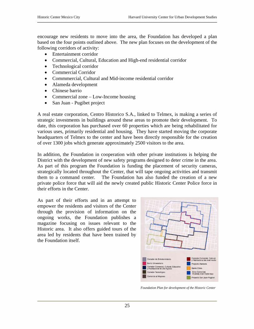
encourage new residents to move into the area, the Foundation has developed a plan based on the four points outlined above. The new plan focuses on the development of the following corridors of activity:
• Entertainment corridor • Commercial, Cultural, Education and High-end residential corridor • Technological corridor • Commercial Corridor • Commmercial, Cultural and Mid-income residential corridor • Alameda development • Chinese barrio • Commercial zone – Low-Income housing • San Juan - Pugibet project
A real estate corporation, Centro Historico S.A., linked to Telmex, is making a series of strategic investments in buildings around these areas to promote their development. To date, this corporation has purchased over 60 properties which are being rehabilitated for various uses, primarily residential and housing. They have started moving the corporate headquarters of Telmex to the center and have been directly responsible for the creation of over 1300 jobs which generate approximately 2500 visitors to the area. In addition, the Foundation in cooperation with other private institutions is helping the District with the development of new safety programs designed to deter crime in the area. As part of this program the Foundation is funding the placement of security cameras, strategically located throughout the Center, that will tape ongoing activities and transmit them to a command center. The Foundation has also funded the creation of a new private police force that will aid the newly created public Historic Center Police force in their efforts in the Center. As part of their efforts and in an attempt to empower the residents and visitors of the Center through the provision of information on the ongoing works, the Foundation publishes a magazine focusing on issues relevant to the Historic area. It also offers guided tours of the area led by residents that have been trained by the Foundation itself.
Foundation Plan for development of the Historic Center
Historic Center Mexico City Harvard University Center for Urban Development Studies
26
Plans and Programs vii Throughout the twentieth century the Historic Center underwent numerous renovation and rehabilitation efforts guided by plans, programs and regulations that intended to revitalize the economy of the area and provide residents with a better quality of life. The following list compiles the most noteworthy interventions in the area by sector. viii Public Works on roadways:
• Cinco de Mayo (1900) • República de Venezuela (1933) • Palma Norte (1933) • San Juan de Letrán-Niño Perdido (1933-
34) • 20 de noviembre (1936) • Anillo de Circumvalación – “Ring Road”
(1941) • Pino Suárez (1950)
• Izazaga-Arcos de Belén (1950-52) • Hidalgo (1952) • Paseo de la Regorma (1958) • Eje 1 Norte Rayón (1978) • Eje 1 Poniente (1978) • Guatemala, Argentina, Moneda &
Corregidora (1978-81) • Eje Central Lázaro Cárdenas (1993) • Avenida Juárez (1997)
Public Transportation:
• Trolley system (1899)
• Metro System (1969) Public Spaces and Monuments:
• Plaza de la Constitución (1931) • Plaza de Santo Domingo (1931) • Plaza de Loreto (1931)
• Calle de la Moneda (1934) • Conjunto de las Vizcaínas (1949) • Templo Mayor (1978-81)
Housing:
• Urban renovation (Indeco, 1974) • Substitution of housing (Banobras, 1975-
76) • Plan Tepito (1972-84) • Acquisition of “vecindades” and
reconstruction of housing (Cuautéhmoc Delegation, Fonhapo, 1984)
• Programa de RHP (1985-86) – “PHRP” • Fase II (1986-87) • Casa Propia (1987-Present) • Expropriation of High Risk Housing
(1996) –See section on lack of adequate housing for further information
Urban plans:
• Echame una manita (1991-94)
• Vivir en el Centro (1995) The most significant projects and programs developed --from the 1990’s to the present-- for the revitalization of the Historic Center have been led by the Historic Center Trusteeship. Beginning in 1991, the Trusteeship developed a fiscal incentive program for owners, investors and even some public institutions (UNAM and the Bank of Mexico among others) wishing to invest in the rehabilitation of buildings in the area. Over the course of 9 years over 85 million dollars were awarded in incentives benefiting the rehabilitation of 547 buildings and leveraging 2.225 billion dollars in investment. These incentives and investments however, were not guided by a regulatory or strategic plan and in effect, projects thrived where the market dictated. Most rehabilitation occurred in the area traditionally known as the financial corridor, focusing mostly on commercial and service uses and excluding 90% of the Historic Center’s area. As a
Historic Center Mexico City Harvard University Center for Urban Development Studies
27
result, in 1998, the Trusteeship was charged with developing a strategic plan for the regeneration and integral development of the Historic Center of the Mexico City. This document would be the seed for the special development program for the Historic Center which includes the three partial programs that dictate land ordinance: Centro Historico, Centro Alameda and La Merced. (See section on Local Issues) The following table outlines the strategies and lines of action defined in that plan. Strategies Lines of Action Reestablishment of centrality
• Reorganization of road and transport system • Relocate, build and improve parking • Rehabilitate the urban image • Recuperate public space • Rescue monuments and heritage sites • Improve and expand the reach of cultural events in the Historic
Center Housing regeneration • Diversify and expand housing availability
• Support housing uses in heritage buildings • Intervene to identify and rehabilitate high risk buildings • Rehabilitate public spaces corresponding to existing popular
neighborhoods • Support the construction of housing in empty lots and those
occupied by ruins • Generate a middle class rental housing market
Economic development • Develop new opportunities related to the tourism market • Make the most of cultural heritage as economic engine • Develop small and micro-enterprises • Control and regulate street vendors
Social development • Coordinate institutions to support the development of a program of aid for vulnerable groups of residents
• Consolidate projects that are being developed by civil and private organizations
• Rehabilitate education, health, social and cultural services • Develop job training programs • Foster the development of public participation and involvement in
activities Table taken from La Ciudad de Mexico en el fin del segundo milenio. P.53.
Historic Center Mexico City Harvard University Center for Urban Development Studies
28
Key Issues in the Development of the Historic Center Regional Issues – Federal District • Water
Perhaps the greatest issue facing the Federal District and thereby the Historic Center is the issue of the exploitation of water resources in the Valley. Buildings in the Historic Center sink approximately 20 cm. per year as a direct result of the depletion of the subterraneous water resources. Water has been pumped out of the lakebed since Spanish colonial rule took over the city. The effects of this depletion are catastrophic for the development of the area resulting in:
o The risk of building collapse; o The accelerated deterioration and eventual destruction of infrastructure
systems due to sinking and; o The risk for infection due to leakage of bacteria onto cracked water lines.
Various private, public and international institutions are looking into the issue of water provision and stabilization of the environment particularly focusing on the following points:
o The filtration of recycled gray water into the lakebed as an alternative for the replenishment of the subterranean water system. – This alternative has been studied by the National Water Corporation and has been determined to be viable and suitable for the City. Currently, a legislation process in underway to make this project possible.
o The lack of capacity of the soil to filter water due to the exploitation of the lakebed, resulting in flooding of certain city areas.
o The need for the improvement of drainage and sewerage systems throughout the City. - The 1928 Trusteeship has as mandate the development of various extensive infrastructure projects, funded by the Inter-American Development Bank for these purposes.
o The imminent need for control of the loss of water in the Federal District. • Earthquakes
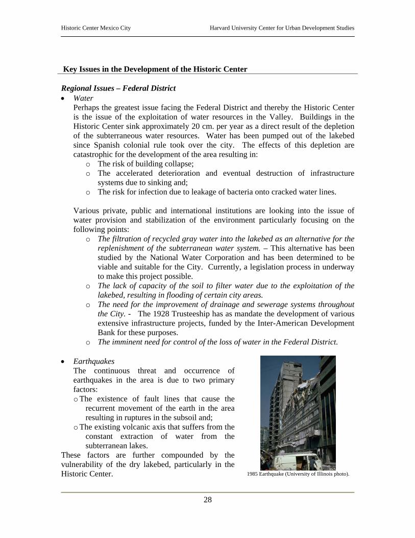
The continuous threat and occurrence of earthquakes in the area is due to two primary factors: o The existence of fault lines that cause the
recurrent movement of the earth in the area resulting in ruptures in the subsoil and;
o The existing volcanic axis that suffers from the constant extraction of water from the subterranean lakes.
These factors are further compounded by the vulnerability of the dry lakebed, particularly in the Historic Center.
1985 Earthquake (University of Illinois photo).
Historic Center Mexico City Harvard University Center for Urban Development Studies
29
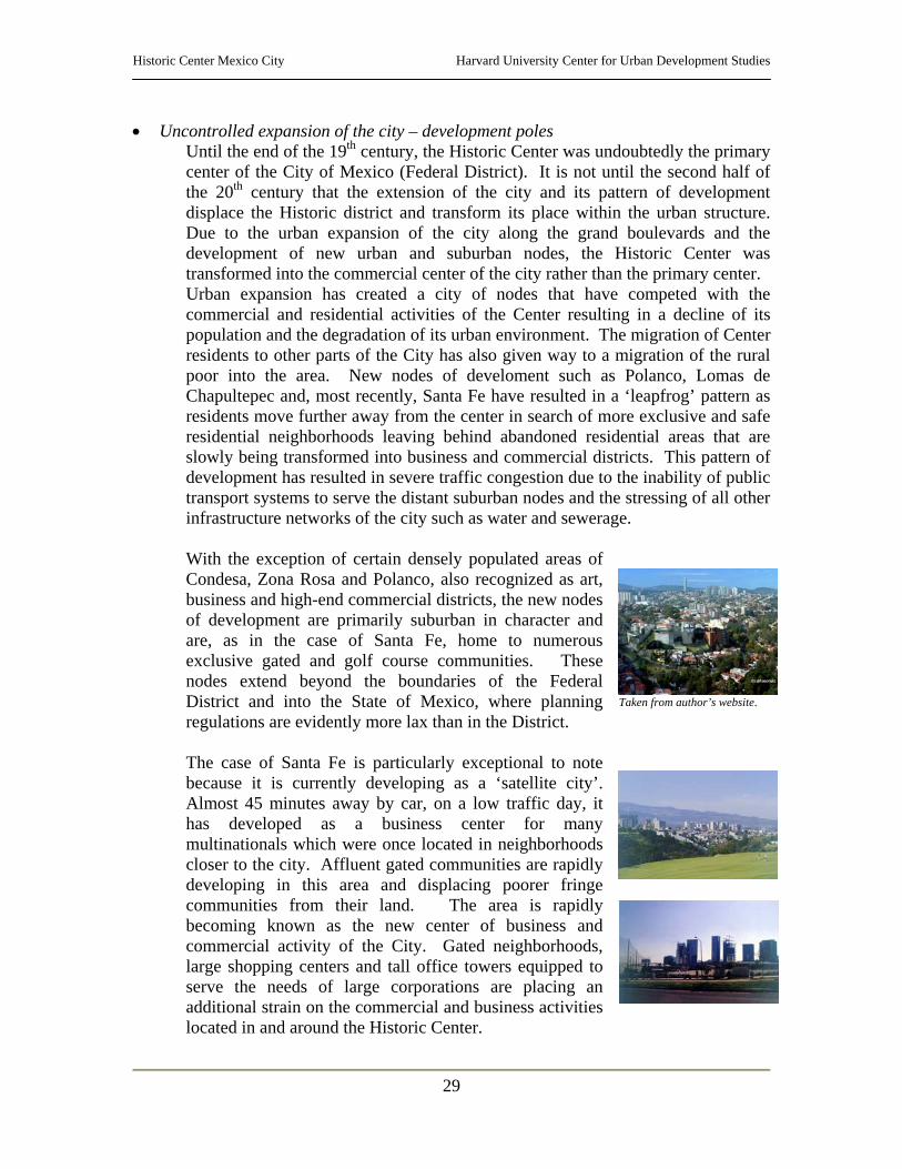
• Uncontrolled expansion of the city – development poles Until the end of the 19th century, the Historic Center was undoubtedly the primary center of the City of Mexico (Federal District). It is not until the second half of the 20th century that the extension of the city and its pattern of development displace the Historic district and transform its place within the urban structure. Due to the urban expansion of the city along the grand boulevards and the development of new urban and suburban nodes, the Historic Center was transformed into the commercial center of the city rather than the primary center. Urban expansion has created a city of nodes that have competed with the commercial and residential activities of the Center resulting in a decline of its population and the degradation of its urban environment. The migration of Center residents to other parts of the City has also given way to a migration of the rural poor into the area. New nodes of develoment such as Polanco, Lomas de Chapultepec and, most recently, Santa Fe have resulted in a ‘leapfrog’ pattern as residents move further away from the center in search of more exclusive and safe residential neighborhoods leaving behind abandoned residential areas that are slowly being transformed into business and commercial districts. This pattern of development has resulted in severe traffic congestion due to the inability of public transport systems to serve the distant suburban nodes and the stressing of all other infrastructure networks of the city such as water and sewerage. With the exception of certain densely populated areas of Condesa, Zona Rosa and Polanco, also recognized as art, business and high-end commercial districts, the new nodes of development are primarily suburban in character and are, as in the case of Santa Fe, home to numerous exclusive gated and golf course communities. These nodes extend beyond the boundaries of the Federal District and into the State of Mexico, where planning regulations are evidently more lax than in the District. The case of Santa Fe is particularly exceptional to note because it is currently developing as a ‘satellite city’. Almost 45 minutes away by car, on a low traffic day, it has developed as a business center for many multinationals which were once located in neighborhoods closer to the city. Affluent gated communities are rapidly developing in this area and displacing poorer fringe communities from their land. The area is rapidly becoming known as the new center of business and commercial activity of the City. Gated neighborhoods, large shopping centers and tall office towers equipped to serve the needs of large corporations are placing an additional strain on the commercial and business activities located in and around the Historic Center.
Taken from author’s website.
Historic Center Mexico City Harvard University Center for Urban Development Studies
30
Nevertheless, the symbolic centrality of the Historic Center cannot be denied. The area is still the cultural and political center of the country with a vast concentration of significant government buildings and services as well as, culturally significant buildings and sites. The Partial Plan for the area declares: “The centrality of the Historic Center is defined by the heterogeneity of its uses.”
Intermediate Issues – Cuautéhmoc and Venustiano Carranza • Lack of coordination and uniformity in intervention
The fact that the Historic Center (Perimeters “A” and “B”) is divided by two jurisdictions has fostered a lack of coordination and uniformity in intervention. Although the delegations are encouraged to work together for the development and rehabilitation of the area, there is no formal agreement between either the delegations or the Federal District to work on the area in an integrated manner.
• Lack of institutional capacity In the much the same way that the area has been divided among multiple jurisdictions and institutions, and left without an integral or coordinated strategy for development, there are numerous institutions at work in the rehabilitation, recuperation and maintenance of the Historic Center. This issue has created an imminent need for an integrated institution that can coordinate the actions and programs of the various national, regional and local institutions that are working in the area, in order to preserve the centrality of the Center within the Federal District while controlling the excessive urban expansion that has characterized the city in the last decades.
Local Issues – Historic Center
• The need for an overall strategy for the rehabilitation and development of the Historic Center. At present there are various plans, strategies and programs that address the rehabilitation of various parts of the Historic Center. However, there is no particular strategy that addresses the Center as a whole or in an integrated manner. Existing legislation and planning regulations to deal with the issues relevant to the development of the Historic Center are inadequate and inaccessible to the public in general. Programs and projects aimed at rehabilitating and renovating the urban environment in the area lack coordination, direction and monitoring. Furthermore, the projects, which are led by public and private initiatives, are not broadcast throughout the community, making community participation difficult and in many instances, limiting participation to certain sectors of the community. The issue of lack of coordination and integration is clearly evidenced by the three separate District partial programs for three separate parts of the Historic Center. The Partial Programs for Urban Development that regulate activities in Perimeters
Historic Center Mexico City Harvard University Center for Urban Development Studies
31
“A” and “B” are: o Centro Alameda – Area east of Eje Central – Lázaro Cárdenas in
Cuauhtémoc Delegation o La Merced – Area east of Eje Oeste – Vidal Alcocer St. in Venustiano
Carranza Delegation o Centro Histórico – Perimeter “A” in Cuauhtémoc Delegation
Partial Plan for Perimeter “A” – Centro Historico Definition of Study Area covered:
• The 1980 decree that declares the creation of the Historic Center of Mexico City, in an area of 9.1 square kilometers that coincides with the general outline of the City at the end of the XIX Century – The decree created Perimeters “A” and “B”, of which “A” represents the area where the majority of buildings of historical value are located.
• 75% of the Historic Center (Perimeters “A” and “B”) is located in Cuauhtémoc Delegation and 25% in V. Carranza Delegation – Furthermore, within Cuauhtémoc Delegation, two subdelegations have territorial jurisdiction over the Historic Center: Subdelegation of the Historic Center (representing most of Perimeter “A”) and Subdelegation Tepito – Guerrero (representing the northern part of the Historic Center, including the remaining portion of Perimeter “A”.
• The importance of the Historic Center for the economic well being of the Federal District and the country is not only notable due to the quality and concentration of economic activity in the area, but also for the concentration of public institutions and cultural symbols.
• Although the Center has seen a population loss in the last decades resulting in the deterioration of the housing stock primarily due to a lack of adequate regulations for the maintenance and construction of housing units in the area and the lack of incentives for the development of housing, it is still an important residential center in the city.
• There are over 1,600 buildings and sites of cultural significance as well as an important concentration of museums, cultural centers, and historical archives within the area known as the Historic Center Perimeter “A”.
Objectives of the Partial Program: • Redefine the role of the Historic Center in the city, the metropolotian area, and
the country, focusing on the recognition of its cultural significance for Mexicans and humanity.
• Build regulatory frameworks that allow the use of built patrimony including public space and buildings.
• Consolidate housing services in the Historic Center, promoting the development of a diversified housing market that meets the needs and capacity of demand.
• Foster partnerships that promote economic activities that are compatible with the rehabilitation of the area.
• Promote actions that improve the quality of life for residents of the Historic Center.
Lines of Action • Rehabilitation of the cultural patrimony • Development of housing • Promotion of diversified economic activity • Redevelopment of public space and its uses
Historic Center Mexico City Harvard University Center for Urban Development Studies
32
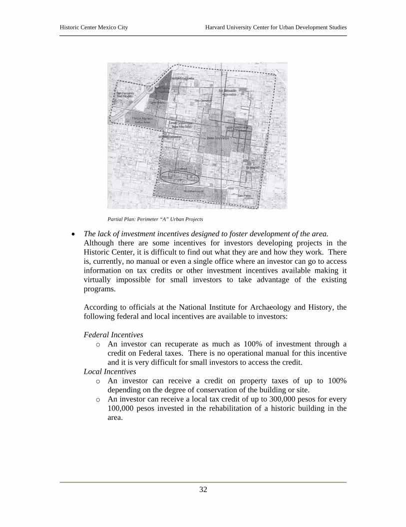
Partial Plan: Perimeter “A” Urban Projects
• The lack of investment incentives designed to foster development of the area. Although there are some incentives for investors developing projects in the Historic Center, it is difficult to find out what they are and how they work. There is, currently, no manual or even a single office where an investor can go to access information on tax credits or other investment incentives available making it virtually impossible for small investors to take advantage of the existing programs. According to officials at the National Institute for Archaeology and History, the following federal and local incentives are available to investors: Federal Incentives
o An investor can recuperate as much as 100% of investment through a credit on Federal taxes. There is no operational manual for this incentive and it is very difficult for small investors to access the credit.
Local Incentives o An investor can receive a credit on property taxes of up to 100%
depending on the degree of conservation of the building or site. o An investor can receive a local tax credit of up to 300,000 pesos for every
100,000 pesos invested in the rehabilitation of a historic building in the area.
Historic Center Mexico City Harvard University Center for Urban Development Studies
33
• The inadequacy of existing social support networks to ensure the inclusion of marginalized residents. Although the Historic Center is home to numerous governmental institutions and non-governmental organizations dedicated to providing social services for the resident population, the area remains poverty stricken, with the average worker earning between 1 and 2 times the minimum wage of 40.35 pesos/day (2001), equivalent to $4.21 USD. This problem is particularly evident in the northern areas of Perimeter “A” and La Merced.
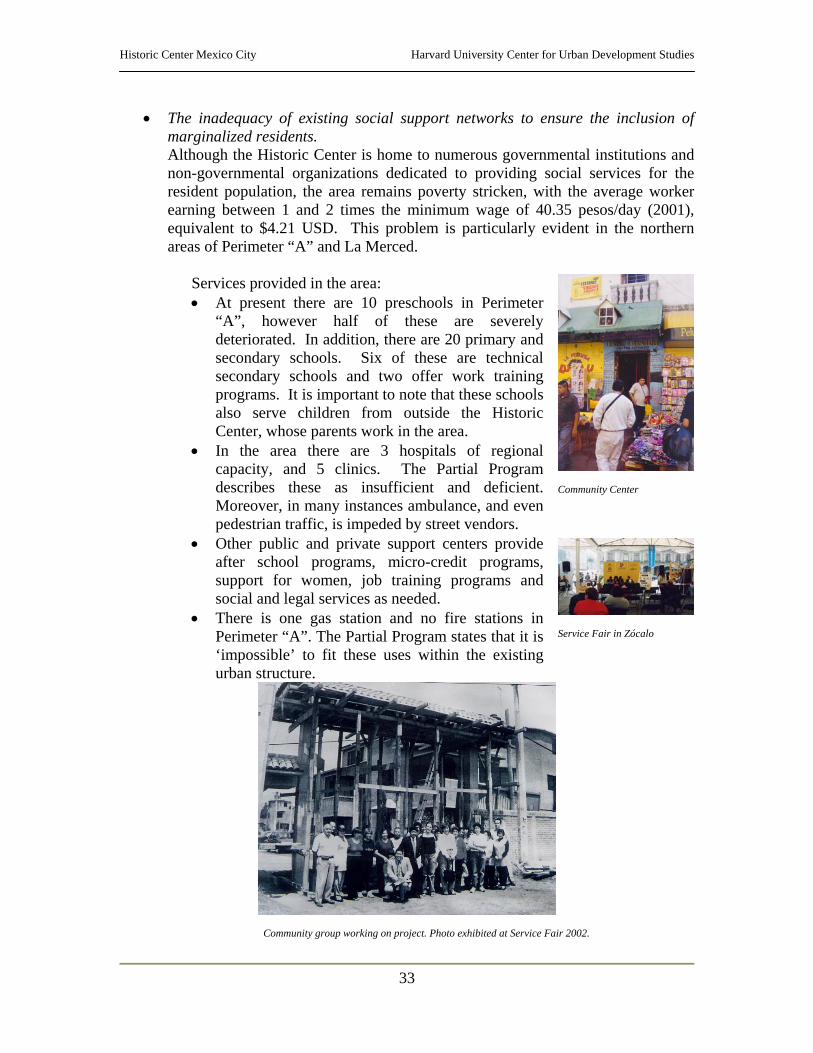
Services provided in the area: • At present there are 10 preschools in Perimeter
“A”, however half of these are severely deteriorated. In addition, there are 20 primary and secondary schools. Six of these are technical secondary schools and two offer work training programs. It is important to note that these schools also serve children from outside the Historic Center, whose parents work in the area.
• In the area there are 3 hospitals of regional capacity, and 5 clinics. The Partial Program describes these as insufficient and deficient. Moreover, in many instances ambulance, and even pedestrian traffic, is impeded by street vendors.
• Other public and private support centers provide after school programs, micro-credit programs, support for women, job training programs and social and legal services as needed.
• There is one gas station and no fire stations in Perimeter “A”. The Partial Program states that it is ‘impossible’ to fit these uses within the existing urban structure.
Community Center
Service Fair in Zócalo
Community group working on project. Photo exhibited at Service Fair 2002.
Historic Center Mexico City Harvard University Center for Urban Development Studies
34
• The impact of excessive commercial activity in an area designated as cultural patrimony.
• Formal Sector The Historic Center has traditionally been the commercial center for the whole city providing the region with goods such as clothing, fabric, jewelry, electronics, shoes, paper, perfumes, toys, arts and crafts, books, leather and home goods. Informally, businesses have located along corridors specializing by item. For example, electronics along Uruguay St., lamps along Victoria St. and printing shops in Plaza Santo Domingo. Commercial activities are the predominant use in the Historic Center. There are 13,039 established businesses, in Perimeter “A” alone, generating an approximate 48,000 jobs. Formally established businesses are represented by the Business Association of the Historic Center. Their objectives are to:
• Serve as liaison between the community and the businesses; • Collaborate with the projects developed by the Trusteeship for the
Historic Center; • Promote the recovery and rehabilitation of the area and; • Work with government officials to develop fiscal incentives to
foster the economic development of the area. The major poles of economic activity in the Center are: Lagunilla Markets, specializing in furniture and clothes; Mixcalco Market, specializing in clothes; Granaditas Market, specializing in clothes; Plaza Meave, specializing in electronics; Plaza Santo Domingo, specializing in printing; El Zócalo, the religious and political center of the country; Plaza Garibaldi, night life center and Bellas Artes, center for cultural activity of the country.
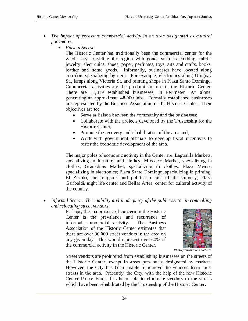
• Informal Sector: The inability and inadequacy of the public sector in controlling
and relocating street vendors. Perhaps, the major issue of concern in the Historic Center is the prevalence and recurrence of informal commercial activity. The Business Association of the Historic Center estimates that there are over 30,000 street vendors in the area on any given day. This would represent over 60% of the commercial activity in the Historic Center.
Photo from author’s website.
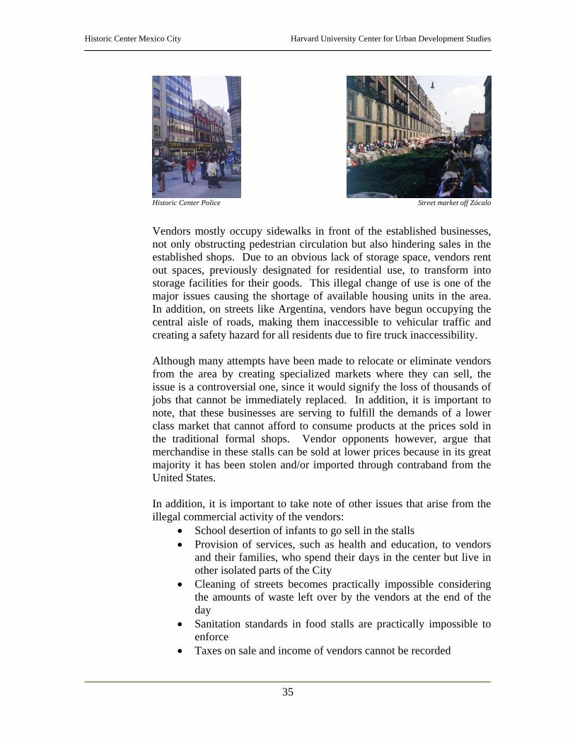
Street vendors are prohibited from establishing businesses on the streets of the Historic Center, except in areas previously designated as markets. However, the City has been unable to remove the vendors from most streets in the area. Presently, the City, with the help of the new Historic Center Police Force, has been able to eliminate vendors in the streets which have been rehabilitated by the Trusteeship of the Historic Center.
Historic Center Mexico City Harvard University Center for Urban Development Studies
35
Historic Center Police
Street market off Zócalo
Vendors mostly occupy sidewalks in front of the established businesses, not only obstructing pedestrian circulation but also hindering sales in the established shops. Due to an obvious lack of storage space, vendors rent out spaces, previously designated for residential use, to transform into storage facilities for their goods. This illegal change of use is one of the major issues causing the shortage of available housing units in the area. In addition, on streets like Argentina, vendors have begun occupying the central aisle of roads, making them inaccessible to vehicular traffic and creating a safety hazard for all residents due to fire truck inaccessibility. Although many attempts have been made to relocate or eliminate vendors from the area by creating specialized markets where they can sell, the issue is a controversial one, since it would signify the loss of thousands of jobs that cannot be immediately replaced. In addition, it is important to note, that these businesses are serving to fulfill the demands of a lower class market that cannot afford to consume products at the prices sold in the traditional formal shops. Vendor opponents however, argue that merchandise in these stalls can be sold at lower prices because in its great majority it has been stolen and/or imported through contraband from the United States. In addition, it is important to take note of other issues that arise from the illegal commercial activity of the vendors:
• School desertion of infants to go sell in the stalls • Provision of services, such as health and education, to vendors
and their families, who spend their days in the center but live in other isolated parts of the City
• Cleaning of streets becomes practically impossible considering the amounts of waste left over by the vendors at the end of the day
• Sanitation standards in food stalls are practically impossible to enforce
• Taxes on sale and income of vendors cannot be recorded
Historic Center Mexico City Harvard University Center for Urban Development Studies
36
Additional facts: • Street vendors primarily sell: toys, seasonal articles, sweets, food, clothes,
crafts, bags, articles for the home, tapes and cosmetics. • The ten largest formal organizations that group street vendors in the
Historic Center are: o Unión Cívica y Comercial de la Antigua Merced: 1,558 o Independientes: 883 o Vendedores unidos del Carmen y Colombia: 337 o Asociación Comercial Deportiva y Cultural para Invidentes y Débiles
Visuales: 309 o Asociación Legítima Cívica y Comercial: 216 o Asociación de Comerciantes en Pequeño No Asalariados Benito
Juárez: 200 o Asociación de Comerciantes Independientes Nuevo milenio: 177 o Comerciantes Independientes de Corregidora/Erasmo Castellanos: 120 o Artesanos y Vendedores del Centro: 105 o Unión Libre de Comerciantes de Meave y Aldaco: 99
• The lack of adequate housing in the area.
Housing in the Federal District is a particularly controversial issue due to the rapid growth and expansion of the city and the natural risk factors that affect development of safe and affordable housing. Following are some of the facts and issues that affect housing development in the area: ix
o Housing uses are concentrated in the northern areas of the Historic Center, occupying 36% of all uses in the area.
o According to the regulations established by the Urban Development Programs, 8,654 lots (88%) are zoned for housing. These occupy a total of 68% of all lots in the Center, although they are mostly small lots with areas of under 1,000 square meters.
o The Historic Center has a potential capacity of 373,462 housing units of 60 square meters each. Most of the potential for housing units is located in the southern strip of Perimeter “B”.
o Taking into account land prices in the area, it is estimated that low-income housing developments would have to be of a density of at least 400 housing units per hectare.
o The six major residential areas of the Center are: Colonia Guerrero, to the North of Alameda; Merced, between Jesús María and Circunvalación; Lagunilla, between República de Cuba and Ecuador; Tepito, on the northwest corner of the Historic Center; Granaditas, to the south of Granaditas market and; Vizcaínas, on San Jerónimo.
o Areas traditionally known as residential neighborhoods in the Historic Center are constantly being transformed to commercial uses and warehouses for street vendors, particularly in the neighborhoods of Lagunilla and Tepito.
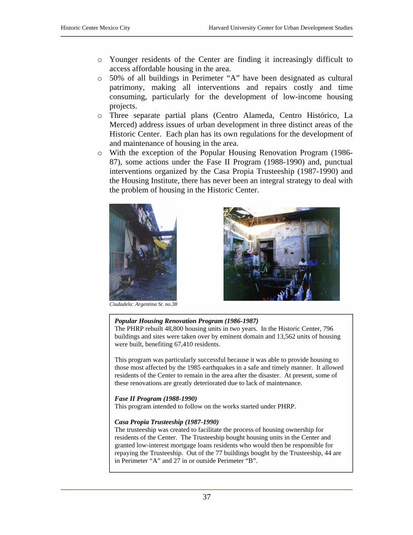
Historic Center Mexico City Harvard University Center for Urban Development Studies
37
o Younger residents of the Center are finding it increasingly difficult to access affordable housing in the area.
o 50% of all buildings in Perimeter “A” have been designated as cultural patrimony, making all interventions and repairs costly and time consuming, particularly for the development of low-income housing projects.
o Three separate partial plans (Centro Alameda, Centro Histórico, La Merced) address issues of urban development in three distinct areas of the Historic Center. Each plan has its own regulations for the development of and maintenance of housing in the area.
o With the exception of the Popular Housing Renovation Program (1986-87), some actions under the Fase II Program (1988-1990) and, punctual interventions organized by the Casa Propia Trusteeship (1987-1990) and the Housing Institute, there has never been an integral strategy to deal with the problem of housing in the Historic Center.
Ciudadela: Argentina St. no.38
Popular Housing Renovation Program (1986-1987) The PHRP rebuilt 48,800 housing units in two years. In the Historic Center, 796 buildings and sites were taken over by eminent domain and 13,562 units of housing were built, benefiting 67,410 residents. This program was particularly successful because it was able to provide housing to those most affected by the 1985 earthquakes in a safe and timely manner. It allowed residents of the Center to remain in the area after the disaster. At present, some of these renovations are greatly deteriorated due to lack of maintenance. Fase II Program (1988-1990) This program intended to follow on the works started under PHRP. Casa Propia Trusteeship (1987-1990) The trusteeship was created to facilitate the process of housing ownership for residents of the Center. The Trusteeship bought housing units in the Center and granted low-interest mortgage loans residents who would then be responsible for repaying the Trusteeship. Out of the 77 buildings bought by the Trusteeship, 44 are in Perimeter “A” and 27 in or outside Perimeter “B”.
Historic Center Mexico City Harvard University Center for Urban Development Studies
38
o The housing problem in the City of Mexico is aggravated by many natural factors such as access to water and risk of earthquakes. It is estimated that 11% of the city’s population is occupying low-income housing units built in sensitive sites located over geologic fault lines, mining areas, river banks and/or areas with insufficient or inexistent infrastructure.
o Natural risks to housing development in the Federal District include:
• Five fault lines that cross over the delegations of Cuauhtémoc, Venustiano Carranza, Benito Juárez and Miguel Hidalgo, affecting more than 425,000 residents
• Mining areas (settlements on steep slopes with a high risk for landslides) in Álvaro Obregón, Gustavo A. Madero and Magdalena Contreras, affecting over 54,000 housing units (10% of all housing units in the District)
• Flood areas in Gustavo A. Madero, Iztacalco, Tláhuac and Magdalena Contreras, affecting 144,598 housing units (14% of all housing units in the District)
• Iztapalapa is crossed by a ground fissure that affects housing units in Ermita Zaragoza and Peñón Viejo
• Chemical and industrial sites in the delegations of Benito Juárez, Cuauhtémoc, Azcapotzalco, Gustavo A. Madero, Tláhuac, Xochimilco and Milpa Alta, affecting 56% of all social housing in the District
• The prevalence of criminal activity in the center.
Criminal activity is consistently cited by residents and visitors of the Historic Center as its major problem. Delinquent activity in the Center ranges from petty theft to murder to contraband and the illegal resale of stolen merchandise – in many cases imported illegally into the country from the United States. Perimeter “A” is the area most affected by crime according to the number of police reports submitted. More secure areas tend to coincide with the residential streets while commercial streets have a tendency of increased criminal activity. Data compiled in 2001, seems to demonstrate that criminal activity is increasing in the northern areas of the Historic Center that are seeing the fastest change in use from residential to informal commercial activity. x As part of the revitalization efforts that are being coordinated between the City and the private investors, a new Historic Center Police Force has been created. This police force will serve solely in the revitalized streets of the Center, that is to say, in the 34 blocks that conform the nucleus. A total of eight police officers is to patrol each block at all times. In addition, security video cameras are being placed in these streets to monitor activity from a central command center. These projects are being instituted in coordination with the proposals made by Rudolph Giuliani, who is currently contracted by the City to develop a new security plan.
Historic Center Mexico City Harvard University Center for Urban Development Studies
39
Endnotes i Information gathered from Guía de Forasteros Centro Histórico Ciudad de México, Guías Turísticas Banamex, S.A. de C.V., Mexico, 1991; Partial Program for the Urban Development of the Historic Center, September 2000 and; www.centrohistorico.df.gob.mx . ii Partial Program for the Urban Development of the Historic Center: September 7, 2000. iii Estimate presented in Proyecto Centro Histórico, Ciudad de Mexico: Informe Final. Prepared by Asamblea de Representantes del Distrito Federal, I Legislatura, Comisión de Desarrollo Metropolitano, and, Mercado y Asociados. 1997. iv Information gathered from http://www.mexicocity.gob.mx/corredores/intro/index.html. v As described in http://www.centrohistorico.df.gob.mx - Site for the Historic Center Trusteeship. vi The Plaza Juarez project includes a commercial area with restaurants, cafes and shops, a residential area, more than 50,000 m2 of office space and parking. The project’s architect is Ricardo Legorreta. vii Information in this section is gathered from La Ciudad de México en el fin del segundo milenio, Gustavo Garza. Gobierno del Distrito Federal & El Colegio de México, Mexico: 2000. viii List compiled in Proyecto Centro Histórico: Ciudad de Mexico, Informe Final 1997. ix Information is gathered from a report made available by the Foundation for the Historic Center and prepared by the UNAM and La Unidad, September-October 2002, Year 3, No. 30. x Information based on a study provided by the Foundation for the Historic Center and developed in the UNAM and La Unidad, September-October 2002, Year 3, No. 30.

Historic Center Mexico City Harvard University Center for Urban Development Studies
40
Annexes
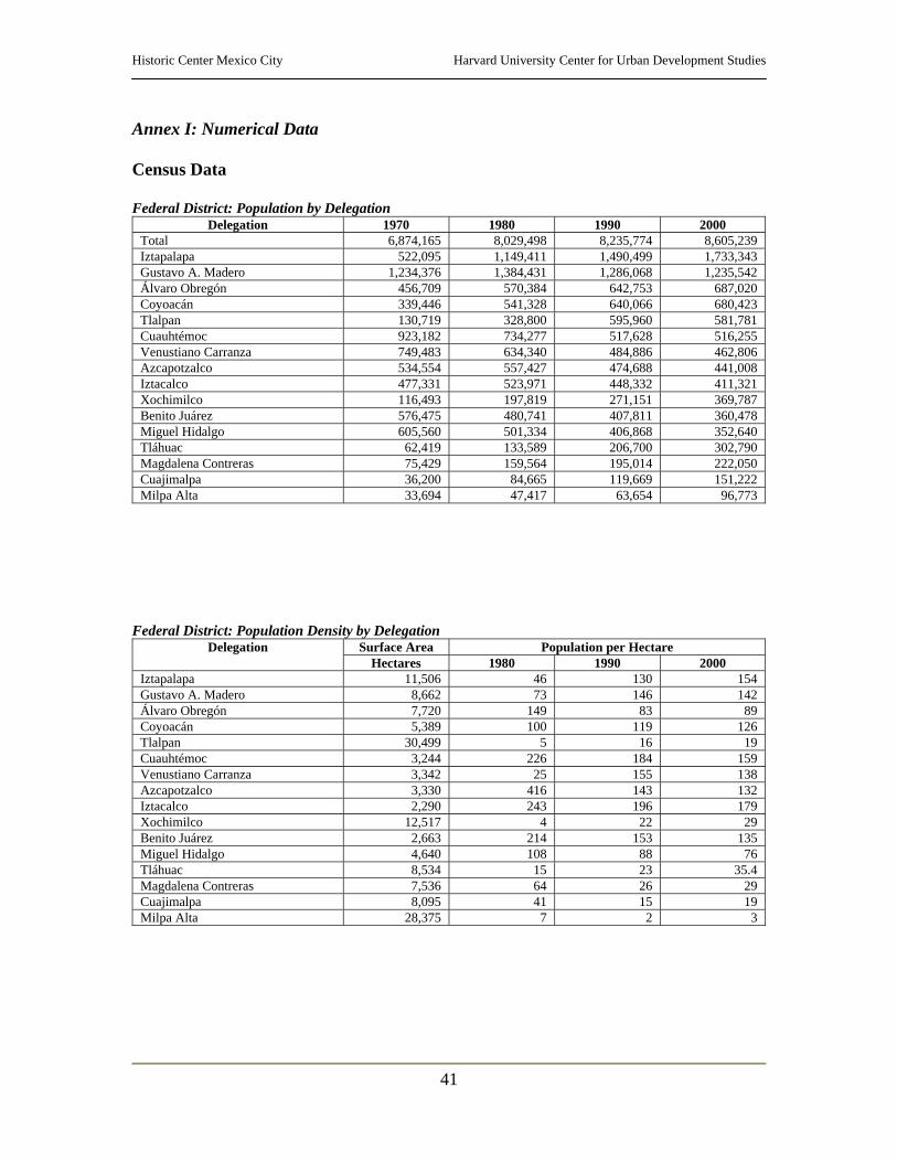
Historic Center Mexico City Harvard University Center for Urban Development Studies
41
Annex I: Numerical Data Census Data Federal District: Population by Delegation
Delegation 1970 1980 1990 2000 Total 6,874,165 8,029,498 8,235,774 8,605,239 Iztapalapa 522,095 1,149,411 1,490,499 1,733,343 Gustavo A. Madero 1,234,376 1,384,431 1,286,068 1,235,542 Álvaro Obregón 456,709 570,384 642,753 687,020 Coyoacán 339,446 541,328 640,066 680,423 Tlalpan 130,719 328,800 595,960 581,781 Cuauhtémoc 923,182 734,277 517,628 516,255 Venustiano Carranza 749,483 634,340 484,886 462,806 Azcapotzalco 534,554 557,427 474,688 441,008 Iztacalco 477,331 523,971 448,332 411,321 Xochimilco 116,493 197,819 271,151 369,787 Benito Juárez 576,475 480,741 407,811 360,478 Miguel Hidalgo 605,560 501,334 406,868 352,640 Tláhuac 62,419 133,589 206,700 302,790 Magdalena Contreras 75,429 159,564 195,014 222,050 Cuajimalpa 36,200 84,665 119,669 151,222 Milpa Alta 33,694 47,417 63,654 96,773
Federal District: Population Density by Delegation
Surface Area Population per Hectare Delegation Hectares 1980 1990 2000
Iztapalapa 11,506 46 130 154 Gustavo A. Madero 8,662 73 146 142 Álvaro Obregón 7,720 149 83 89 Coyoacán 5,389 100 119 126 Tlalpan 30,499 5 16 19 Cuauhtémoc 3,244 226 184 159 Venustiano Carranza 3,342 25 155 138 Azcapotzalco 3,330 416 143 132 Iztacalco 2,290 243 196 179 Xochimilco 12,517 4 22 29 Benito Juárez 2,663 214 153 135 Miguel Hidalgo 4,640 108 88 76 Tláhuac 8,534 15 23 35.4 Magdalena Contreras 7,536 64 26 29 Cuajimalpa 8,095 41 15 19 Milpa Alta 28,375 7 2 3
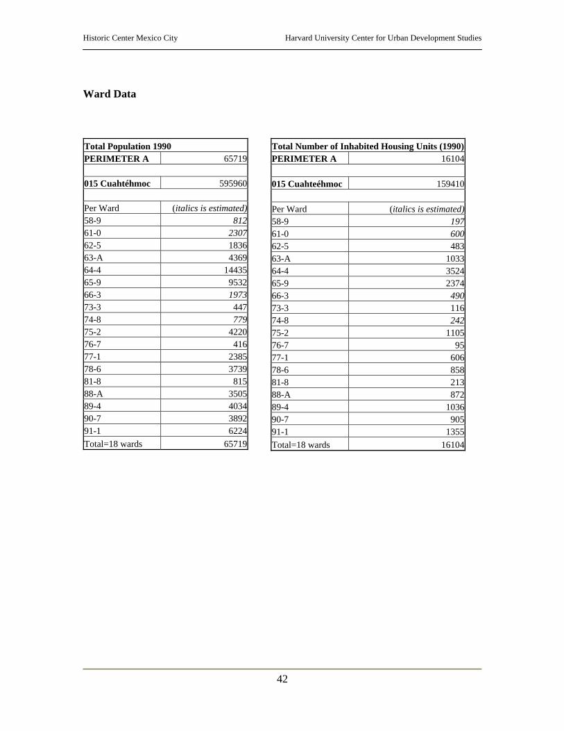
Historic Center Mexico City Harvard University Center for Urban Development Studies
42
Ward Data Total Population 1990 PERIMETER A 65719 015 Cuahtéhmoc 595960 Per Ward (italics is estimated)58-9 81261-0 230762-5 183663-A 436964-4 1443565-9 953266-3 197373-3 44774-8 77975-2 422076-7 41677-1 238578-6 373981-8 81588-A 350589-4 403490-7 389291-1 6224Total=18 wards 65719
Total Number of Inhabited Housing Units (1990)PERIMETER A 16104 015 Cuahteéhmoc 159410 Per Ward (italics is estimated)58-9 19761-0 60062-5 48363-A 103364-4 352465-9 237466-3 49073-3 11674-8 24275-2 110576-7 9577-1 60678-6 85881-8 21388-A 87289-4 103690-7 90591-1 1355Total=18 wards 16104
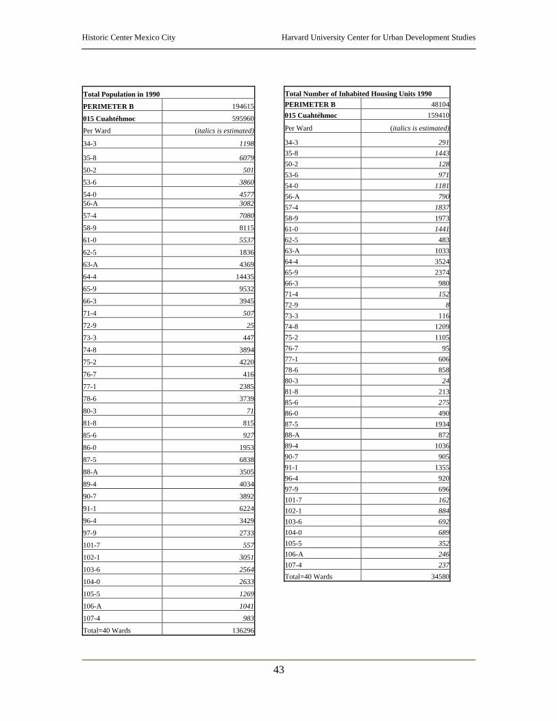
Historic Center Mexico City Harvard University Center for Urban Development Studies
43
Total Population in 1990
PERIMETER B 194615
015 Cuahtéhmoc 595960
Per Ward (italics is estimated)
34-3 1198
35-8 6079
50-2 501
53-6 3860
54-0 457756-A 3082
57-4 7080
58-9 8115
61-0 5537
62-5 1836
63-A 4369
64-4 14435
65-9 9532
66-3 3945
71-4 507
72-9 25
73-3 447
74-8 3894
75-2 4220
76-7 416
77-1 2385
78-6 3739
80-3 71
81-8 815
85-6 927
86-0 1953
87-5 6838
88-A 3505
89-4 4034
90-7 3892
91-1 6224
96-4 3429
97-9 2733
101-7 557
102-1 3051
103-6 2564
104-0 2633
105-5 1269
106-A 1041
107-4 983
Total=40 Wards 136296
Total Number of Inhabited Housing Units 1990 PERIMETER B 48104015 Cuahtéhmoc 159410
Per Ward (italics is estimated)
34-3 29135-8 144350-2 12853-6 97154-0 118156-A 79057-4 183758-9 197361-0 144162-5 48363-A 103364-4 352465-9 237466-3 98071-4 15272-9 873-3 11674-8 120975-2 110576-7 9577-1 60678-6 85880-3 2481-8 21385-6 27586-0 49087-5 193488-A 87289-4 103690-7 90591-1 135596-4 92097-9 696101-7 162102-1 884103-6 692104-0 689105-5 352106-A 246107-4 237Total=40 Wards 34580

Historic Center Mexico City Harvard University Center for Urban Development Studies
44
Total Population in 1990
017 V. Carranza 519628
Per Ward (italics is estimated)
21-0 1346
22-5 1940
24-4 870
25-9 601
26-3 1032
36-7 6773
37-1 7804
38-6 747
39-0 5380
40-3 3234
48-A 5937
49-4 6083
50-7 2864
57-9 2490
58-3 4410
59-8 7
68-7 1333
69-1 3453
70-4 23
89-9 1336
90-1 656
Total=21 Wards 58319
Total Number of Inhabited Housing Units 1990 017 V. Carranza 117820Per Ward (italics is estimated)
21-0 309
22-5 43924-4 17625-9 21226-3 22936-7 162437-1 185538-6 16039-0 125840-3 72348-A 136949-4 143150-7 69657-9 53958-3 98259-8 068-7 28569-1 77570-4 589-9 29790-1 160Total=21 Wards 13524
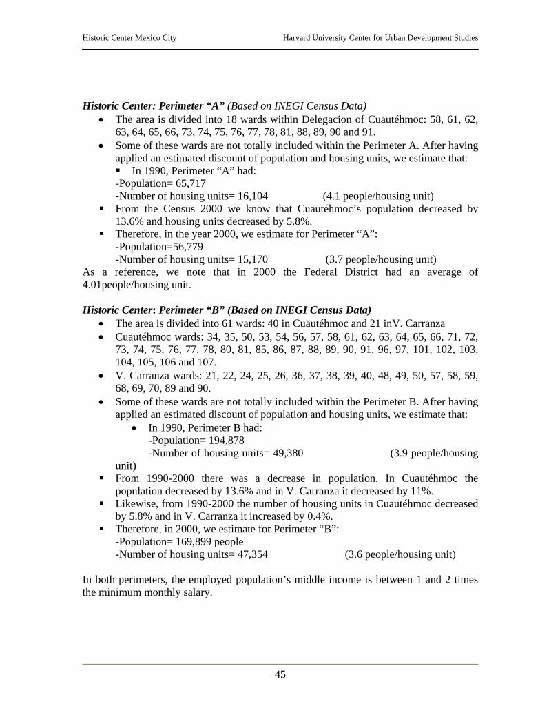
Historic Center Mexico City Harvard University Center for Urban Development Studies
45
Historic Center: Perimeter “A” (Based on INEGI Census Data)
• The area is divided into 18 wards within Delegacion of Cuautéhmoc: 58, 61, 62, 63, 64, 65, 66, 73, 74, 75, 76, 77, 78, 81, 88, 89, 90 and 91.
• Some of these wards are not totally included within the Perimeter A. After having applied an estimated discount of population and housing units, we estimate that: In 1990, Perimeter “A” had:
-Population= 65,717 -Number of housing units= 16,104 (4.1 people/housing unit)
From the Census 2000 we know that Cuautéhmoc’s population decreased by 13.6% and housing units decreased by 5.8%.
Therefore, in the year 2000, we estimate for Perimeter “A”: -Population=56,779 -Number of housing units= 15,170 (3.7 people/housing unit) As a reference, we note that in 2000 the Federal District had an average of 4.01people/housing unit. Historic Center: Perimeter “B” (Based on INEGI Census Data)
• The area is divided into 61 wards: 40 in Cuautéhmoc and 21 inV. Carranza • Cuautéhmoc wards: 34, 35, 50, 53, 54, 56, 57, 58, 61, 62, 63, 64, 65, 66, 71, 72,
73, 74, 75, 76, 77, 78, 80, 81, 85, 86, 87, 88, 89, 90, 91, 96, 97, 101, 102, 103, 104, 105, 106 and 107.
• V. Carranza wards: 21, 22, 24, 25, 26, 36, 37, 38, 39, 40, 48, 49, 50, 57, 58, 59, 68, 69, 70, 89 and 90.
• Some of these wards are not totally included within the Perimeter B. After having applied an estimated discount of population and housing units, we estimate that:
• In 1990, Perimeter B had: -Population= 194,878 -Number of housing units= 49,380 (3.9 people/housing unit)
From 1990-2000 there was a decrease in population. In Cuautéhmoc the population decreased by 13.6% and in V. Carranza it decreased by 11%.
Likewise, from 1990-2000 the number of housing units in Cuautéhmoc decreased by 5.8% and in V. Carranza it increased by 0.4%.
Therefore, in 2000, we estimate for Perimeter “B”: -Population= 169,899 people -Number of housing units= 47,354 (3.6 people/housing unit) In both perimeters, the employed population’s middle income is between 1 and 2 times the minimum monthly salary.
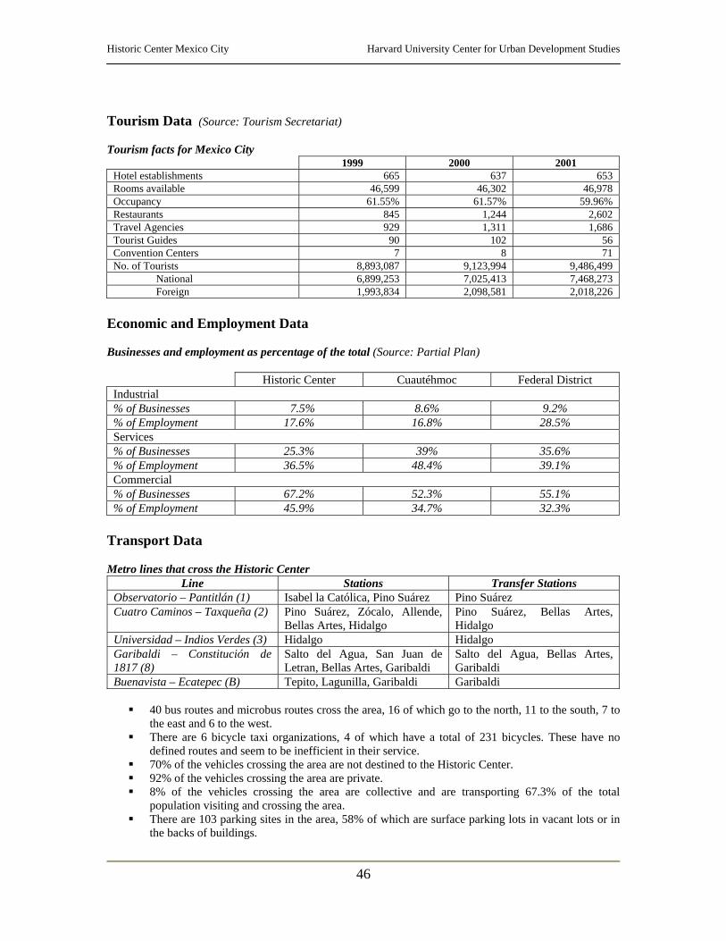
Historic Center Mexico City Harvard University Center for Urban Development Studies
46
Tourism Data (Source: Tourism Secretariat) Tourism facts for Mexico City
1999 2000 2001 Hotel establishments 665 637 653 Rooms available 46,599 46,302 46,978 Occupancy 61.55% 61.57% 59.96% Restaurants 845 1,244 2,602 Travel Agencies 929 1,311 1,686 Tourist Guides 90 102 56 Convention Centers 7 8 71 No. of Tourists 8,893,087 9,123,994 9,486,499
National 6,899,253 7,025,413 7,468,273 Foreign 1,993,834 2,098,581 2,018,226
Economic and Employment Data Businesses and employment as percentage of the total (Source: Partial Plan)
Historic Center Cuautéhmoc Federal District Industrial % of Businesses 7.5% 8.6% 9.2% % of Employment 17.6% 16.8% 28.5% Services % of Businesses 25.3% 39% 35.6% % of Employment 36.5% 48.4% 39.1% Commercial % of Businesses 67.2% 52.3% 55.1% % of Employment 45.9% 34.7% 32.3%
Transport Data Metro lines that cross the Historic Center
Line Stations Transfer Stations Observatorio – Pantitlán (1) Isabel la Católica, Pino Suárez Pino Suárez Cuatro Caminos – Taxqueña (2) Pino Suárez, Zócalo, Allende,
Bellas Artes, Hidalgo Pino Suárez, Bellas Artes, Hidalgo
Universidad – Indios Verdes (3) Hidalgo Hidalgo Garibaldi – Constitución de 1817 (8)
Salto del Agua, San Juan de Letran, Bellas Artes, Garibaldi
Salto del Agua, Bellas Artes, Garibaldi
Buenavista – Ecatepec (B) Tepito, Lagunilla, Garibaldi Garibaldi
40 bus routes and microbus routes cross the area, 16 of which go to the north, 11 to the south, 7 to the east and 6 to the west.
There are 6 bicycle taxi organizations, 4 of which have a total of 231 bicycles. These have no defined routes and seem to be inefficient in their service.
70% of the vehicles crossing the area are not destined to the Historic Center. 92% of the vehicles crossing the area are private. 8% of the vehicles crossing the area are collective and are transporting 67.3% of the total
population visiting and crossing the area. There are 103 parking sites in the area, 58% of which are surface parking lots in vacant lots or in
the backs of buildings.
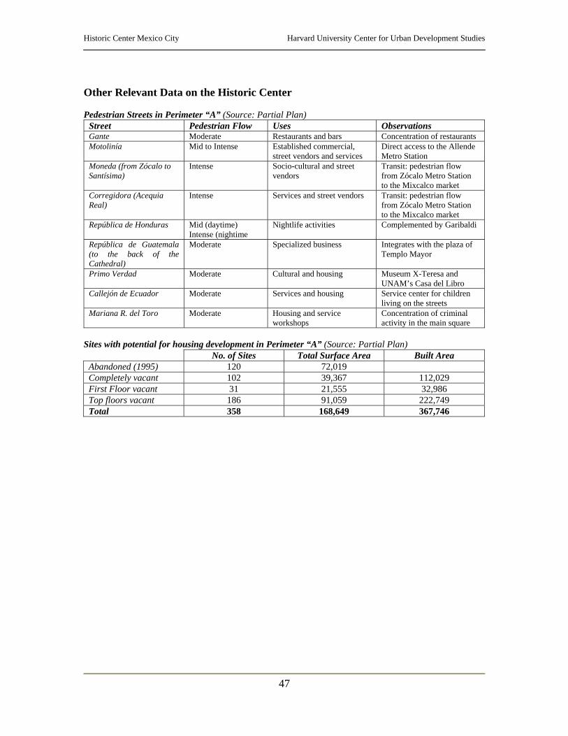
Historic Center Mexico City Harvard University Center for Urban Development Studies
47
Other Relevant Data on the Historic Center Pedestrian Streets in Perimeter “A” (Source: Partial Plan)
Street Pedestrian Flow Uses Observations Gante Moderate Restaurants and bars Concentration of restaurants Motolinía Mid to Intense Established commercial,
street vendors and services Direct access to the Allende Metro Station
Moneda (from Zócalo to Santísima)
Intense Socio-cultural and street vendors
Transit: pedestrian flow from Zócalo Metro Station to the Mixcalco market
Corregidora (Acequia Real)
Intense Services and street vendors Transit: pedestrian flow from Zócalo Metro Station to the Mixcalco market
República de Honduras Mid (daytime) Intense (nightime
Nightlife activities Complemented by Garibaldi
República de Guatemala (to the back of the Cathedral)
Moderate Specialized business Integrates with the plaza of Templo Mayor
Primo Verdad Moderate Cultural and housing Museum X-Teresa and UNAM’s Casa del Libro
Callejón de Ecuador Moderate Services and housing Service center for children living on the streets
Mariana R. del Toro Moderate Housing and service workshops
Concentration of criminal activity in the main square
Sites with potential for housing development in Perimeter “A” (Source: Partial Plan)
No. of Sites Total Surface Area Built Area Abandoned (1995) 120 72,019 Completely vacant 102 39,367 112,029 First Floor vacant 31 21,555 32,986 Top floors vacant 186 91,059 222,749 Total 358 168,649 367,746
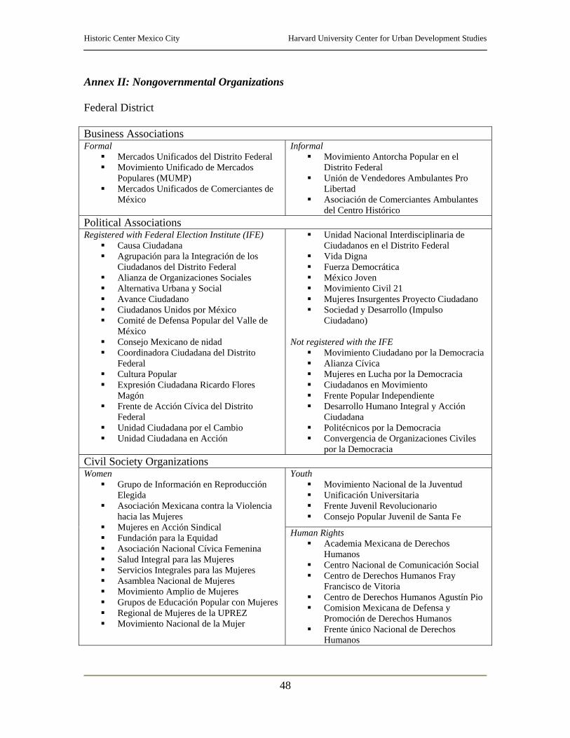
Historic Center Mexico City Harvard University Center for Urban Development Studies
48
Annex II: Nongovernmental Organizations Federal District Business Associations Formal
Mercados Unificados del Distrito Federal Movimiento Unificado de Mercados
Populares (MUMP) Mercados Unificados de Comerciantes de
México
Informal Movimiento Antorcha Popular en el
Distrito Federal Unión de Vendedores Ambulantes Pro
Libertad Asociación de Comerciantes Ambulantes
del Centro Histórico Political Associations Registered with Federal Election Institute (IFE)
Causa Ciudadana Agrupación para la Integración de los
Ciudadanos del Distrito Federal Alianza de Organizaciones Sociales Alternativa Urbana y Social Avance Ciudadano Ciudadanos Unidos por México Comité de Defensa Popular del Valle de
México Consejo Mexicano de nidad Coordinadora Ciudadana del Distrito
Federal Cultura Popular Expresión Ciudadana Ricardo Flores
Magón Frente de Acción Cívica del Distrito
Federal Unidad Ciudadana por el Cambio Unidad Ciudadana en Acción
Unidad Nacional Interdisciplinaria de Ciudadanos en el Distrito Federal
Vida Digna Fuerza Democrática México Joven Movimiento Civil 21 Mujeres Insurgentes Proyecto Ciudadano Sociedad y Desarrollo (Impulso
Ciudadano) Not registered with the IFE
Movimiento Ciudadano por la Democracia Alianza Cívica Mujeres en Lucha por la Democracia Ciudadanos en Movimiento Frente Popular Independiente Desarrollo Humano Integral y Acción
Ciudadana Politécnicos por la Democracia Convergencia de Organizaciones Civiles
por la Democracia Civil Society Organizations
Youth Movimiento Nacional de la Juventud Unificación Universitaria Frente Juvenil Revolucionario Consejo Popular Juvenil de Santa Fe
Women Grupo de Información en Reproducción
Elegida Asociación Mexicana contra la Violencia
hacia las Mujeres Mujeres en Acción Sindical Fundación para la Equidad Asociación Nacional Cívica Femenina Salud Integral para las Mujeres Servicios Integrales para las Mujeres Asamblea Nacional de Mujeres Movimiento Amplio de Mujeres Grupos de Educación Popular con Mujeres Regional de Mujeres de la UPREZ Movimiento Nacional de la Mujer
Human Rights Academia Mexicana de Derechos
Humanos Centro Nacional de Comunicación Social Centro de Derechos Humanos Fray
Francisco de Vitoria Centro de Derechos Humanos Agustín Pio Comision Mexicana de Defensa y
Promoción de Derechos Humanos Frente único Nacional de Derechos
Humanos
Historic Center Mexico City Harvard University Center for Urban Development Studies
49
Professional
Colegio de Arquitectos e Ingenieros Civiles
Asociación Nacional de Abogados Democráticos
Health Red de Grupos para la Salud de la Mujer y
el Niño Promoción de Servicios en Salud y
Educación Popular Family
Comité Nacional Pro Vida Enlace Istituto Mexicano de Doctrina Social
Cristiana Centro Cívico de Solidaridad
Gay & Lesbian Colectivo Sol Círculo Cultural Gay
Promotion, Community Development, Housing and Services
Foro de Apoyo Mutuo Centro Cívico de Solidaridad Desarrollo y Paz Equipo Pueblo Enlace Comunitario y Capacitación Sociedad Mexicana de Instituciones de
Asistencia Privada Promoción del Desarrollo Popular Centro Operacional de Vivienda y
Poblamiento Fomento Solidario para la Vivienda Casa y Ciudad Centro de la Vivienda y Estudios Urbanos Casa y Ciudad HIC – México
Territorial By Colony
Unión Popular Revolucionaria Emiliano Zapata
Frente Popular Francisco Villa Independiente Azcapotzalco
Unión Popular Nueva Tenochtitlan Asamblea de Varrios independiente
Azcapotzalco Asamblea de Barrios de la Ciudad de
México Asamblea de Barrios Patria Nueva Unión de Colonias Populares Central Unitaria de Trabajadores Lucha Independiente por una Vivienda
Digna Movimiento Popular de Pueblos y
Colonias del Sur Movimiento de de Lomas de la Era Movimiento Popular Independiente Unión de Colonos de Santo Domingo Pueblo en Lucha. San Andrés Totoltepec Organización de Colonos de Ciudad
Satélite
By Neighborhood Zedec Polanco Zedec Barranca de Tarango Zedec Centro Histórico de Coyoacán Zedec del Carment Coyoacán Zedec Romero de Terreros Consejo Ciudadano de la Delegación
Benito Juárez Asociación de Residentes del Barrio de
Santa Catarina y San Francisco de Coyoacán
Asociación de Residentes de la Colonia del Carmen Coyoacán
Comités Vecinales de la Delegación Iztacalco
Comités Vecinales de la Delegación Venustiano Carranza
Convergencia Tlalpan Unión de Vecinos y Damnificados 19 de
Septiembre Unión de Vecinos de la Colonia Guerrero Unión Popular Valle Gómez Coordinadora de Cuartos de Azotea de
Tlatelolco – Unión de Cuartos de Azotea e Inquilinos
Asociación de Amigos y Residentes del Centro Histórico de Coyoacán
Calpulli - Nápoles
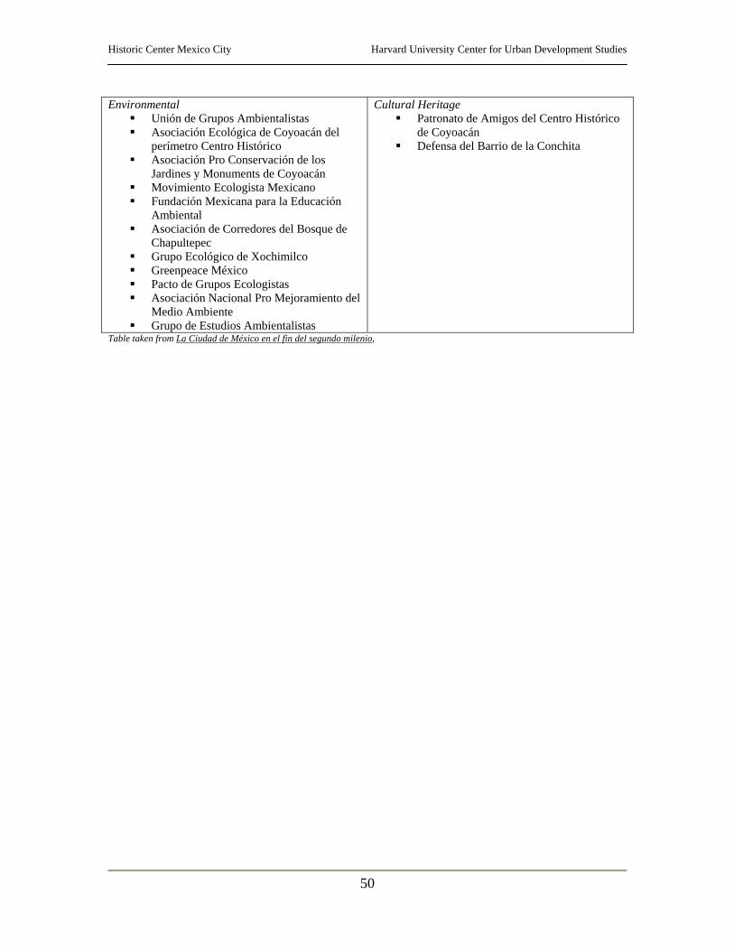
Historic Center Mexico City Harvard University Center for Urban Development Studies
50
Environmental Unión de Grupos Ambientalistas Asociación Ecológica de Coyoacán del
perímetro Centro Histórico Asociación Pro Conservación de los
Jardines y Monuments de Coyoacán Movimiento Ecologista Mexicano Fundación Mexicana para la Educación
Ambiental Asociación de Corredores del Bosque de
Chapultepec Grupo Ecológico de Xochimilco Greenpeace México Pacto de Grupos Ecologistas Asociación Nacional Pro Mejoramiento del
Medio Ambiente Grupo de Estudios Ambientalistas
Cultural Heritage Patronato de Amigos del Centro Histórico
de Coyoacán Defensa del Barrio de la Conchita
Table taken from La Ciudad de México en el fin del segundo milenio,
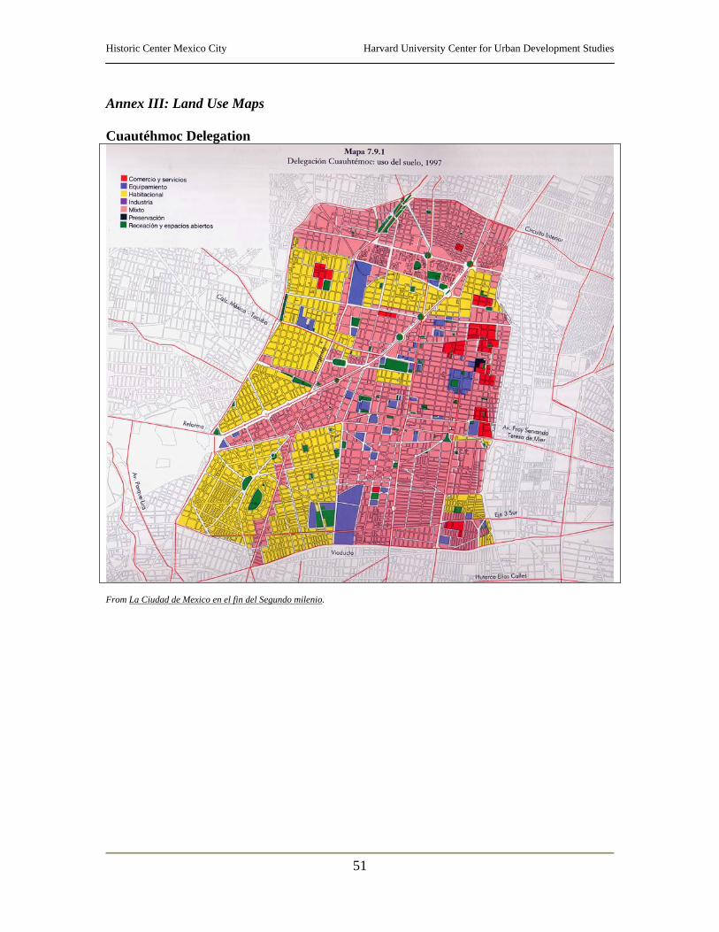
Historic Center Mexico City Harvard University Center for Urban Development Studies
51
Annex III: Land Use Maps Cuautéhmoc Delegation
From La Ciudad de Mexico en el fin del Segundo milenio.
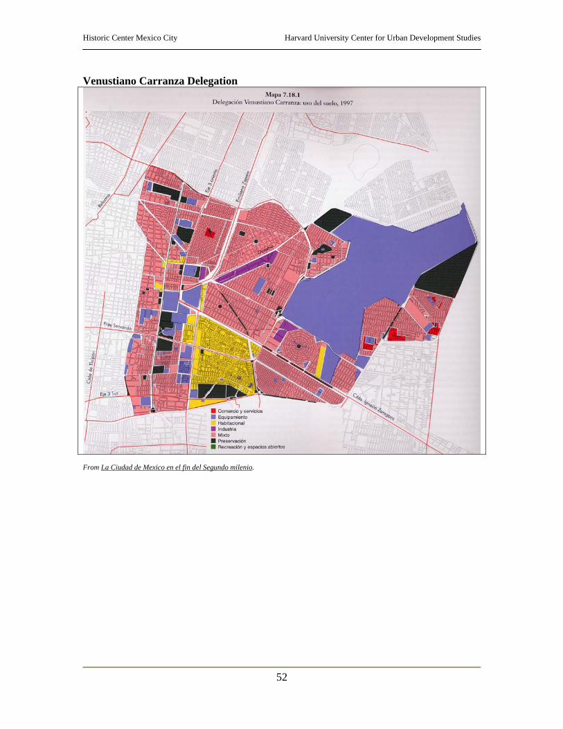
Historic Center Mexico City Harvard University Center for Urban Development Studies
52
Venustiano Carranza Delegation
From La Ciudad de Mexico en el fin del Segundo milenio.
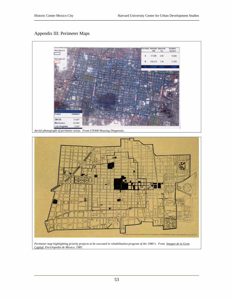
Historic Center Mexico City Harvard University Center for Urban Development Studies
53
Appendix III: Perimeter Maps
Aerial photograph of perimeter areas. From UNAM Housing Diagnostic.
Perimeter map highlighting priority projects to be executed in rehabilitation program of the 1980’s. From Imagen de la Gran Capital, Enciclopedia de Mexico. 1985.
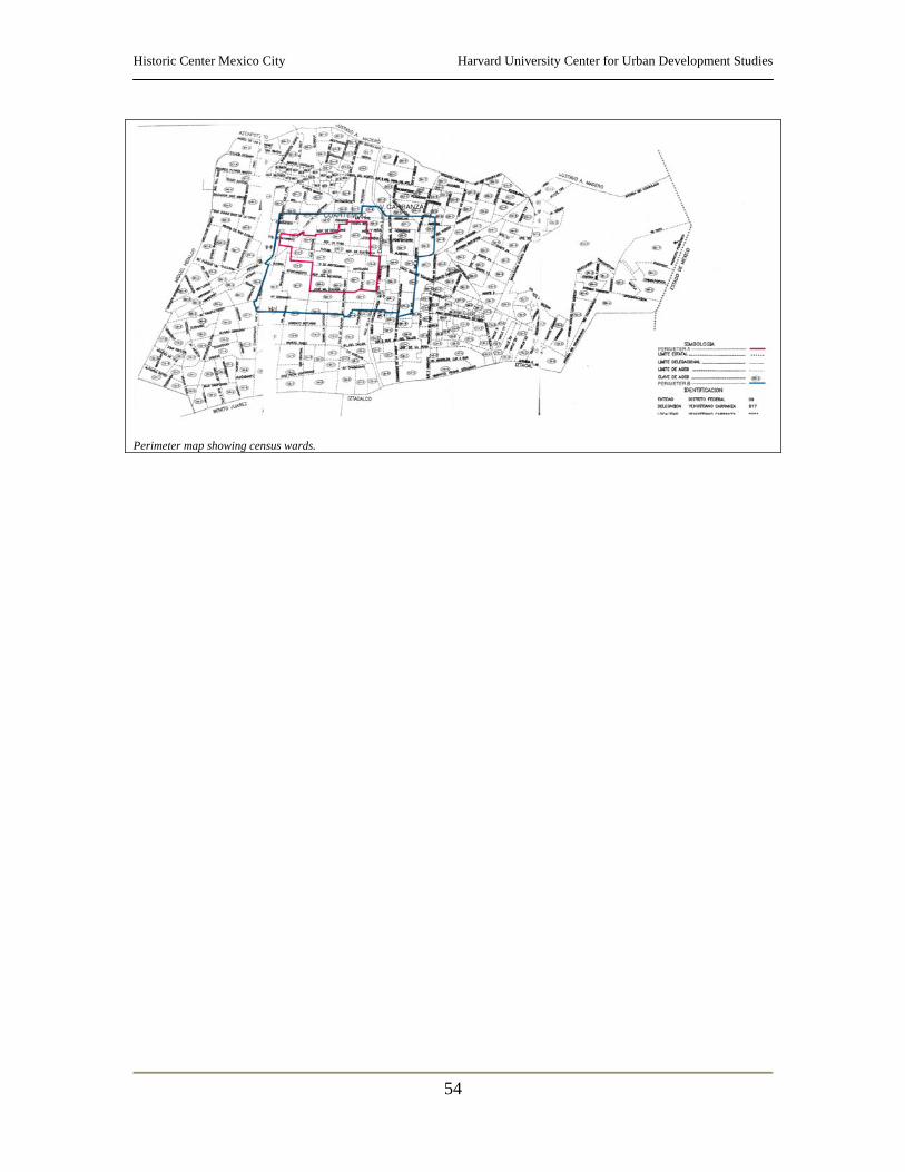
Historic Center Mexico City Harvard University Center for Urban Development Studies
54
Perimeter map showing census wards.
Historic Center Mexico City Harvard University Center for Urban Development Studies
55
References XI Censo de población y Vivienda. INEGI, México 1990. XI Censo de población y Vivienda. INEGI, México 2000. UNAM Housing Diagnostic. With La Unidad, September-October 2002, Year 3, No. 30. Legal and Regulatory texts: Decreto por el que se aprueba el Programa Parcial de desarrollo urbano La Merced del programa delegacional de desarrollo urbano para la Delegación de Venustiano Carranza. Gaceta Oficial del Distrito Federal, Ciudad de México, 14 de julio de 2000. Decreto por el que se aprueba el Programa Parcial de desarrollo urbano Centro Histórico del programa delegacional de desarrollo urbano para la Delegación de Cuautéhmoc. Gaceta Oficial del Distrito Federal, Ciudad de México, 7 de septiembre de 2000. Decreto por el que se aprueba el Programa Parcial de desarrollo urbano Centro Alameda del programa delegacional de desarrollo urbano para la Delegación de Cuautéhmoc. Gaceta Oficial del Distrito Federal, Ciudad de México, 15 de septiembre de 2000. Articles, newspapers and magazines: Pineda, Irasema, “Reabren cuatro calles del Centro; salieron de ellas los ambulantes”, El Heraldo de Mexico, p. 1 and 8A, November 19, 2002. Flores, Jesus, “Reabren el Centro, sin ambulantes”, unomasuno, p. 1 and 10, November 19, 2002. “Muestra para recordar el rencuentro diplomático de Mexico y Madrid”, La Jornada, p. cultura 3a., November 19, 2002. Also in El Heraldo de Mexico, p. 7-A, November 21, 2002. “Enloquece a DF conflicto agrario”, Ciudad y Metrópolis, p.1 November 22, 2002. Photos of traffic congestion “Requieren mejoras instalaciones de CU”, Ciudad y Metrópolis, p. 5B, November 22, 2002. La Unidad (Órgano informativo bimestral para los habitantes de las unidades habitacionales de la Ciudad de México). Julio/ Agosto, Septiembre/ Octubre and Noviembre/ Diciembre.
Historic Center Mexico City Harvard University Center for Urban Development Studies
56
Compilation of social, cultural and art related articles from the web (La jornada virtu@l and Milenio.com) Centro, “Guia para caminantes”. Ritos y Retos del Centro Histórico, Nos. 15, 19 and 20. El Centro, Guia-cartelera del Centro Histórico de la Ciudad de Mexico. Nov/ Dec.
Mexico City and Delegations: Asamblea de Representantes del Distrito Federal, Comisión de Desarrollo Metropolitano, Proyecto Centro Histórico: Ciudad de Mexico, Informe Final, 1997. Conozca su Delegacion, Centro Histórico. Departamento del D.F. Guia de Forasteros Centro Histórico Ciudad de México. Guias turísticas Banamex, S.A. de C.V., Mexico D.F., 1991. Gustavo Garza, La Ciudad de México en el fin del segundo milenio, Gobierno del Distrito Federal & El Colegio de México, Mexico, 2000. Imagen de la Gran capital. Enciclopedia de México, S.A. de C.V. Ciudad de México, 1985. Suarez Zozaya, Ma. Helinda (coord.), Educación en el Distritio Federal, Gobierno del Distrito Federal, 1999. Ver y hacer en la Ciudad de Mexico y alrededores, Guia Turística. Quimera ed., 2002. Visitas del Centro Histórico, Introducción. Centro de Estudios de Historia de México. World Heritage in Mexico. Fondo Editorial de la Plástica Mexicana, Mexico D.F., 1998. CD ROM: Coordinación Nacional de Monumentos Históricos. Fichas y planos del Centro Histórico de México. Instituto Nacional de Antropologia e Historia (INAH). Nov. 2002. Las Ciudades Mexicanas del Patrimonio Mundial. INAH, 2001. 1a Reunión Internacional, Metodologias de catalogación e inventario del patrimonio cultural. INAH, 1998. Catálogo Nacional de Monumentos Históricos Inmuebles. INAH, 2002.
Historic Center Mexico City Harvard University Center for Urban Development Studies
57
Brochures: Residencial Club de Golf Bosques Turismo Ciudad de México 3ra Feria de Servicios para unidades habitacionales y condominios INFONAVIT Instituto de la Mujer del D.F. Dirección General de Regularización Territorial Web sites: www.gob.mx www.df.gob.mx www.centrohistorico.com.mx www.mexicocity.gob.mx www.centrohistorico.df.gob.mx